Modeling of Intra-Channel Belt Depositional Architecture in Fluvial Reservoir Analogs from the Lourinha Formation, Portugal*
|
|
|
- Delilah Underwood
- 6 years ago
- Views:
Transcription
1 Modeling of Intra-Channel Belt Depositional Architecture in Fluvial Reservoir Analogs from the Lourinha Formation, Portugal* Anneli Ekeland 1, Nina Pedersen 1, John Howell 1, Wojtek Nemec 2, Kevin Keogh 3 and Ingunn Viste 1 Search and Discovery Article #50146 (2008) Posted November 20, 2008 *Adapted from oral presentation at AAPG Annual Convention, San Antonio, TX, April 20-23, CIPR, University of Bergen, Bergen, Norway. (john.howell@geo.uib.no) 2 Earth Sciences, University of Bergen, Bergen, Norway. 3 Statoil, Stavanger, Norway. Abstract Fluvial channel and channel belt deposits are commonly represented in subsurface reservoir models using an object-based approach that stochastically places a channel facies in a background of overbank deposits. The internal heterogeneity within the channel is usually represented by adding intra-body trends to the petrophysics. The aim of this study has been to study high-quality outcrop analogs, to collect data, and to build small-scale, geocellular models that capture the macro-form scale detail of the intra-channel architecture. The Jurassic Lourinha Formation crops out in high-quality coastal outcrops in the Lusitanian Basin of Portugal. The studied interval is a mixed net:gross fluvial succession that is considered to be an analog for the Triassic and Lower Jurassic, Statfjord and Lunde reservoirs of the North Sea. Five separate, well exposed channel bodies were selected for study covering a range of stratigraphic settings and fluvial styles. Detailed, logging, photomontaging and bedform architecture studies were supplemented by laser scanning and the building of virtual outcrops. Bar and macro-form bounding surfaces were recorded and reconstructed using the outcrop data and a conceptual understanding of bedform architecture. The reconstructed bedform bounding surfaces and logs were imported into a geocellular modeling package and models capturing the geometry of the surfaces and the detail of the facies between them were built. Each model is at a comparable scale to a single grid cell in a typical simulation model (c.100 x 100 x 5 m) and can be used to investigate the dynamic influence of the main intra-body heterogeneities through upscaling and reservoir flow-simulation studies. Models have also been built using a process-oriented stratigraphic modeling tool to compare and contrast results.
2 Modeling of Intra-Channel Belt Depositional Architecture in Fluvial Reservoir Analogs from the Lourinha Formation, Portugal Anneli Ekeland 1,2, Nina Pedersen 1,3, John Howell 1,4 Wojtek Nemec 1, Kevin Keogh 2 and Ingunn Viste 1 1 Centre for Integrated Petroleum Research/Department of Earth Sciences, Allegt. 41, University of Bergen, N5007 Norway ( john.howell@geo.uib.no) 2 StatoilHydro, Stavanger, Norway 3 Odin Petroleum, Bergen, Norway 4 Rocksource ASA, Bergen, Norway


3 Reservoir modeling of channels Fluvial channel belts are typically y represented as objects in reservoir models However they may contain significant heterogeneity that is not captured


4 Heterogeneity exists at a range of different scale This study concentrates t on the facies association and facies scale (Modified from Keogh et. al, 2007)


5 Study area West coast of Portugal 20+ km of high quality coastal exposure Exposure is largely 2D, but a series of bays and headlands gives an excellent 3D component, especially at the smaller scale
6 Study area


7 Geological setting Central Lusitanian Basin Tectonically active rift basin Opening of North Atlantic Ocean Faults and halokinesis i Sub-basins Consolaçao Sub-Basin Graben structure, elongated N-S Drainage towards SW (Courtesy of Ichron) (Statoil internal report, 2007)


8 Geological setting Stratigraphic framework from extensive ongoing study by StatoilHydro and Ichron
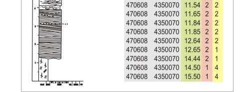
9 Data Collection Data were collected over 5 field seasons Data collection included the recording of closely spaced (5-10 m), detailed sedimentary logs Paleocurrent and structural measurements Photo montaging and architectural t element analysis Lidar scanning and the generation of Virtual Outcrops
10 Towards northeast A B

11 Facies and Facies associations


12 FA1 Channel fill FA1a - Downstream accretion bar Extensive Convex upward shape Erosive base Poorly sorted, granule rich, coarse to very coarse grained sandstones Trough- and planar cross-stratification Main transport direction towards S-SE


13 FA1 Channel fill FA1b - Point bar Lateral accretion surfaces Dominantly medium and fine grained sandstones Moderate to poorly sorted Planar- and trough cross-stratification Occasional ripple cross-lam. on top Transport directions varies between SE and SW

14 FA1 Channel fill FA1c - Chute channel Lens shaped 1-2m thick Traced for approximately 10m Erode into underlying point bars Both mudstone- and sandstone Both mudstone and sandstone filled


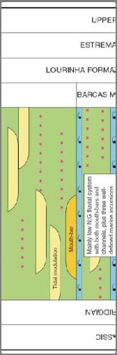
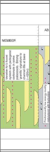
15 FA2 Channel Abandonment In between channel bodies Muddy siltstone Dark grey colour Variable extension and thickness Usually eroded by overlying deposits


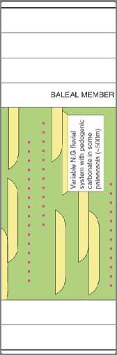
16 FA3 Floodplain and FA4 - Palaeosol Occurs above and below channel complex Mudstone/siltstone and very fine grained sandstone Mottled variegated colour Carbonaceous aceous debris and pedogenic structures
17 Bedform reconstruction Modified from Miall (1988a) Modified after Bridge
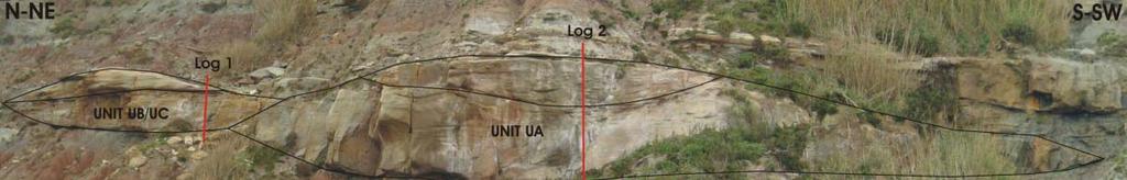
18 Bedform reconstruction Channel complex Ve-C1-2 Multi-storey channel complex 2 stacked channels 3 main depositional episodes Channel 1 Unit 1A, 1B and 1C Meandering character FA1b: Point bar FA1c: Chute channel FA2: Channel Abandonment
 Point bars (FA1b) Migration towards west by both expansion and translation Topography")
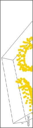
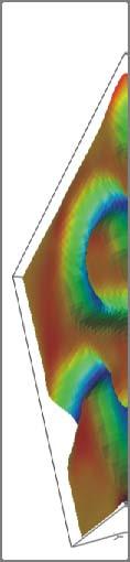
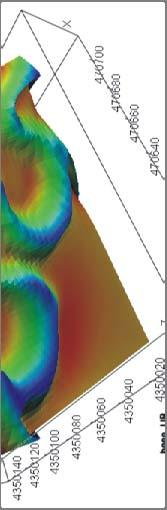
19 Bedform reconstruction Channel 1 Unit 1A Base of Channel 1 90x120m Structural data extrapolated from outcrop (blue line) Point bars (FA1b) Migration towards west by both expansion and translation Topography max. 4m
20 Bedform reconstruction Channel 1 Unit 1B 90x120m Only preserved in the south Erosive event (east west), sediment bypass Incision Point bars (FA1b) overlapping in a downstream direction Mainly migration by translation Topography max. 4.5m (only 2.5m preserved in the outcrop)
21 Bedform reconstruction Channel 1 Unit 1C 90x120m frame Upper part of Channel 1 Point bars (FA1b) and Chute channel (FA1c) Migration towards west by translation and expansion (sinuosity increase) Topography max. 2.5m


22 Bedform reconstruction Channel 1 Summary of Channel 1 deposition migration tow. west erosion/sed.bypass incision deposition erosion deposition migration toward west General trend; migration towards west


23 Geological modelling Datum surface
24 Geological modelling Surfaces Ve-C1-2_Channel Ch 1 Unit 1A Unit 1B Unit 1C Top model


25 Geological modelling Zones Ve-C1-2_Channel 1 Represent the volume between two surfaces Each zone comprises part of the channel fill 4 zones Base of each zone represent the base of a unit Green = Unit 1A, light blue = Green Unit 1A, light blue Unit 1B, dark blue = Unit 1C and purple = Top model.
 Regular grid Follows guide surface which is parallel to")

26 Geological modelling Grid design Grid resolution 2x2x0.2m (XYZ) Regular grid Follows guide surface which is parallel to palaeo-horizontal Capture both the onlapping geometries and the eroded geometries at the top of the model Same gridding strategy for all zones


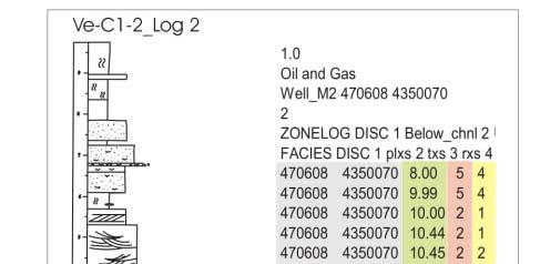
27 Geological modelling - results Unit 1A Modelling facies 1. Planar cross-strat. sst 2. Trough cross-strat. sst 3. Ripple cross-lam. sst 4. Silt Grids populated with facies Variety of methods Facies:composite Object based approach Ellipses, 10-20m long m thick Manual editing to fit the conceptual model


28 Geological modelling - results Unit 1B Modelling facies 1. Planar cross-strat. sst 2. Trough cross-strat. sst 3. Ripple cross-lam. sst 4. Silt


29 Geological modelling - results Unit 1C f Modelling facies 1. Planar cross-strat. sst 2. Trough cross-strat. sst 3. Ripple cross-lam. sst 4. Silt


30 Geological modelling - results All units Modelling facies 1. Planar cross-strat. sst 2. Trough cross-strat. sst 3. Ripple cross-lam. sst 4. Silt
31 Geological modelling - results A B C Comparision between outcrop and geo-model A. Outcrop B. Zones C. Facies model
32 Applications of the models Capture of small scale facies architecture in larger scale flow simulation models Oil field specific petrophysical and PVT properties can be placed within the small scale facies models and used for upscaling in order to derive appropriate values for larger scale models Testing of sensitivites to facies architecture Understanding of 3D connectivity Training of geologist (and engineers) Populating process based models for upscaling


33 SBed Modelling SBEd and SBEd studio SBed studio is a process based geometrical modelling designed for recreating accurate facies models Data from the field and from the models above are being used to condition a series of models Models are used to test facies architecture sensitivities to parameters such as net:gross, sinuosity etc Work is ongoing
34 Conclusions Channel scale heterogeneities can be captured in small scale 3D models Bedform bounding surfaces can be reconstructed from 2D outcrops These surfaces can be imported into reservoir modelling software and used as a basis for models Logs and outcrop information provide input for facies distribution Small scale reservoir models are an integral part of upscaling and reservoir modelling


35
36 Acknowledgments Acknowledgments: StatoilHydro for funding and field co-operation Ichron for an introduction to the field area, geological and logistical support Simon Buckley and Tobias Kurz for virtual outcrop geology work Roxar for RMS Software Geomodelling for SBed and SBed studio software
37 Selected References Dreyer, T., A. Scheie, and O. Walderhaug, 1990, Minipermeameter-based study of permeability trends in channel sand bodies: AAPG Bulletin, v. 74/4, p Keogh, K.J., A.W. Martinius, and R. Osland, 2007, The development of fluvial stochastic modelling in the Norwegian oil industry; a historical review, subsurface implementation and future directions: Sedimentary Geology, v. 202/1-2, p Miall, A.D., 1988, Architectural elements and bounding surfaces in fluvial deposits; anatomy of the Kayenta Formation (Lower Jurassic), Southwest Colorado: sedimentary Geology, v. 55/3-4, p Weber, D.D., and G.T. Flatman, 1986, Subsurface contamination mapping from EMI soundings: SEB Abstracts, v. 1, p
Lecture 19: Fluvial Facies
 GEOL 440 Sedimentology and stratigraphy: processes, environments and deposits Lecture 19: Fluvial Facies Aims Examine controls on alluvial channel pattern List the types of channel pattern Examine meandering
Outcrops from Every Continent and 20 Countries in 140 Contributions. Tor H. Nilsen, Roger D. Shew, Gary S. Steffens, and Joseph R.J. Studlick.
 Paper VIII Tor H. Nilsen, Roger D. Shew, Gary S. Steffens, and Joseph R.J. Studlick Editors Outcrops from Every Continent and 20 Countries in 140 Contributions http://bookstore.aapg.org Length ~ 23 m (75.5
Modeling Lateral Accretion in McMurray Formation Fluvial- Estuarine Channel Systems: Grizzly Oil Sands May River SAGD Project, Athabasca
 Modeling Lateral Accretion in McMurray Formation Fluvial- Estuarine Channel Systems: Grizzly Oil Sands May River SAGD Project, Athabasca Duncan Findlay, Thomas Nardin, Alex Wright, Raheleh Salehi Mojarad
Holocene Sediments of the Rhine-Meuse-Scheldt Estuaries as Aids to Interpret Tidal and Fluvial-Tidal Deposits in Outcrop and Core*
 Holocene Sediments of the Rhine-Meuse-Scheldt Estuaries as Aids to Interpret Tidal and Fluvial-Tidal Deposits in Outcrop and Core* Allard W. Martinius 1 and J.H. (Janrik) van den Berg 2 Search and Discovery
3D geologic modelling of channellized reservoirs: applications in seismic attribute facies classification
 first break volume 23, December 2005 technology feature 3D geologic modelling of channellized reservoirs: applications in seismic attribute facies classification Renjun Wen, * president and CEO, Geomodeling
Deterministic, Process Based Modeling of the Deepwater Fill of the Peïra Cava Basin, SE France*
 Deterministic, Process Based Modeling of the Deepwater Fill of the Peïra Cava Basin, SE France* Romain Rouzairol 1, Riccardo Basani 2, Ernst W.M. Hansen 2, John A. Howell 3, and Tor E. Aas 4 Search and
Modeling Lateral Accretion in McMurray Formation Fluvial-Estuarine Channel Systems: Grizzly Oil Sands May River SAGD Project, Athabasca*
 Modeling Lateral Accretion in McMurray Formation Fluvial-Estuarine Channel Systems: Grizzly Oil Sands May River SAGD Project, Athabasca* Duncan Findlay 1, Thomas Nardin 1, Alex Wright 1, and Raheleh Salehi
Bulletin of Earth Sciences of Thailand
 Depositional Environments and Stratigraphic Development of the Grand Taman Sari Circuit Outcrop: an Analogue for Transgressive Mahakam Delta Successions Ridha Santika Riadi Petroleum Geoscience Program,
Sarah Jane Riordan. Australian School of Petroleum University of Adelaide March 2009
 Managing the Interdisciplinary Requirements of 3D Geological Models Sarah Jane Riordan Australian School of Petroleum University of Adelaide March 2009 Thesis submitted in accordance with the requirements
Bulletin of Earth Sciences of Thailand
 Quantitative Seismic Geomorphology of Early Miocene to Pleistocene Fluvial System of Northern Songkhla Basin, Gulf of Thailand Oanh Thi Tran Petroleum Geoscience Program, Department of Geology, Faculty
Reservoir Modelling of a Bioclastic Calcarenite Complex on Favignana, Southern Italy: The Application of Multi-point Statistics*
 Reservoir Modelling of a Bioclastic Calcarenite Complex on Favignana, Southern Italy: The Application of Multi-point Statistics* Robert Kil 1 and Andrea Moscariello 2,3 Search and Discovery Article #50548
GeoCanada 2010 Working with the Earth
 Lithofacies Identification and the Implications for SAGD Well Planning in the McMurray Formation, Christina Lake Area, Alberta Travis Shackleton*, Robert Gardner, Sung Youn, Grace Eng and Lori Barth Cenovus
Chapter 8: Learning objectives
 Chapter 8: Learning objectives Understand concept of sedimentary facies Signinifance of lateral and vertical facies associations Walther s Law Understand the sedimentary facies of alluvial fans, eolian
Recent developments in object modelling opens new era for characterization of fluvial reservoirs
 Recent developments in object modelling opens new era for characterization of fluvial reservoirs Markus L. Vevle 1*, Arne Skorstad 1 and Julie Vonnet 1 present and discuss different techniques applied
Introduction. Milovan Fustic 1, Rudy Strobl 1, Bryce Jablonski 1, Torgrim Jacobsen 2, Eirik Vik 2, and Allard W. Martinius 1
 McMurray Formation Type Section Outcrop: Part 1 - a world class learning lab for fluvio - tidal sedimentology, petroleum systems and reservoir characterization & Part 2 an unparalleled portal for SAGD
Relinquishment Report. for. Licence P1605, Block 220/27
 Relinquishment Report for Licence P1605, Block 220/27 November 2013 Licence P.1605 Relinquishment Report August 2012 1 of 11 CONTENT 1 Introduction 2 - Exploration Summary 2.1 Exploration Activity 2.2
Reservoir characterization
 1/15 Reservoir characterization This paper gives an overview of the activities in geostatistics for the Petroleum industry in the domain of reservoir characterization. This description has been simplified
Geo 302D: Age of Dinosaurs. LAB 2: Sedimentary rocks and processes
 Geo 302D: Age of Dinosaurs LAB 2: Sedimentary rocks and processes Last week we covered the basic types of rocks and the rock cycle. This lab concentrates on sedimentary rocks. Sedimentary rocks have special
OUTCROP! CHARACTERISATION! OF! TRANSGRESSIVE! SANDSTONE! RESERVOIRS:! QUANTITATIVE!COMPARISON!OF!OUTCROP!ANALOGUES!
 OUTCROP CHARACTERISATION OF TRANSGRESSIVE SANDSTONE RESERVOIRS: QUANTITATIVECOMPARISONOFOUTCROPANALOGUES OLIVER D. JORDAN 1, PETER J. SIXSMITH 2, GARY J. HAMPSON, SANJEEV GUPTA & HOWARDD.JOHNSON DepartmentofEarthScienceandEngineering,ImperialCollegeLondon,SouthKensington
Sediment and sedimentary rocks Sediment
 Sediment and sedimentary rocks Sediment From sediments to sedimentary rocks (transportation, deposition, preservation and lithification) Types of sedimentary rocks (clastic, chemical and organic) Sedimentary
Stochastic Simulation of Inclined Heterolithic Stratification with Streamline-based Stochastic Models
 Stochastic Simulation of Inclined Heterolithic Stratification with Streamline-based Stochastic Models Michael J. Pyrcz and Clayton V. Deutsch Department of Civil and Environmental Engineering, University
SUPPLEMENTAL INFORMATION DELFT 3-D MODELING: MODEL DESIGN, SETUP, AND ANALYSIS
 GSA DATA REPOSITORY 2014069 Hajek and Edmonds SUPPLEMENTAL INFORMATION DELFT 3-D MODELING: MODEL DESIGN, SETUP, AND ANALYSIS Each experiment starts from the initial condition of a straight channel 10 km
Fluid-Mud Deposits of the Lower Jurassic Tilje Formation, Offshore Mid-Norway By Aitor A. Ichaso and Robert W. Dalrymple 1
 Fluid-Mud Deposits of the Lower Jurassic Tilje Formation, Offshore Mid-Norway By Aitor A. Ichaso and Robert W. Dalrymple 1 Search and Discovery Article #50107 (2008) Posted August 10, 2008 *Adapted from
High-resolution Sequence Stratigraphy of the Glauconitic Sandstone, Upper Mannville C Pool, Cessford Field: a Record of Evolving Accommodation
 Page No. 069-1 High-resolution Sequence Stratigraphy of the Glauconitic Sandstone, Upper Mannville C Pool, Cessford Field: a Record of Evolving Accommodation Thérèse Lynch* and John Hopkins, Department
Accommodation. Tectonics (local to regional) Subsidence Uplift
 Subsidence Uplift") Accommodation Accommodation varies over time; it is the distance between a reference horizon and the sea surface (i.e. relative sea level). The space to be filled in with sediments or water What are the
Accommodation Accommodation varies over time; it is the distance between a reference horizon and the sea surface (i.e. relative sea level). The space to be filled in with sediments or water What are the
FUTURE MEANDER BEND MIGRATION AND FLOODPLAIN DEVELOPMENT PATTERNS NEAR RIVER MILES 241 TO 235, SACRAMENTO RIVER
 FUTURE MEANDER BEND MIGRATION AND FLOODPLAIN DEVELOPMENT PATTERNS NEAR RIVER MILES 241 TO 235, SACRAMENTO RIVER Eric W. Larsen University of California, Davis With the assistance of Evan Girvetz REPORT
Exploration Significance of Unconformity Structure on Subtle Pools. 1 Vertical structure characteristics of unconformity
 Exploration Significance of Unconformity Structure on Subtle Pools Wu Kongyou (China University of Petroleum,College of Geo-Resources and Information,Shandong Qingdao 266555) Abstract: Vertical structure
Facies Analysis Of The Reservoir Rocks In The. Sylhet Trough, Bangladesh. Abstract
 Facies Analysis Of The Reservoir Rocks In The Sylhet Trough, Bangladesh Joyanta Dutta Petroleum Geoscience Program, Department of Geology, Faculty of Science, Chulalongkorn University, Bangkok 10330, Thailand
Southern Songkhla Basin, Gulf of Thailand
 Architecture and Depositional Environment of Fluvial Systems of Southern Songkhla Basin, Gulf of Thailand Toan Manh Do Petroleum Geoscience Program, Department of Geology, Faculty of Science, Chulalongkorn
Data Repository item
 Data Repository (B25407): Localities and descriptions of measured sections of study areas Table 1. Localities of the measured sedimentary sections in the NW Sichuan Basin Section Number Stratigraphy Locality
Sedimentary System Characteristics of Deng-3 Section on Paleo-central. Uplift Belt in Northern Songliao Basin. Siyang Li1,a*
 Sedimentary System Characteristics of Deng-3 Section on Paleo-central Uplift Belt in Northern Songliao Basin Siyang Li1,a* 1 School of Earth Sciences and Resources, China University of Geosciences, Beijing,
Search and Discovery Article #40536 (2010) Posted June 21, 2010
 Posted June 21, 2010") Modern Examples of Mass Transport Complexes, Debrite and Turbidite Associations: Geometry, Stratigraphic Relationships and Implications for Hydrocarbon Trap Development* Fabiano Gamberi 1, Marzia Rovere
Modern Examples of Mass Transport Complexes, Debrite and Turbidite Associations: Geometry, Stratigraphic Relationships and Implications for Hydrocarbon Trap Development* Fabiano Gamberi 1, Marzia Rovere
Sedimentary and Stratigraphic Analysis of the Viking Sand in the Edgerton/Wainwright Area, Central Alberta* By Russell Walz 1
 Sedimentary and Stratigraphic Analysis of the Viking Sand in the Edgerton/Wainwright Area, Central Alberta* By Russell Walz 1 Search and Discovery Article #50030 (2006) Posted June 25, 2006 *Extended abstract
Abstract. *Modified from extended abstract prepared for presentation at AAPG Annual Convention, Calgary, Alberta, June 19-22, 2005
 The Jurassic-Cretaceous North Sea Rift Dome and Associated Basin Evolution* By Ole Graversen 1 Search and Discovery Article #30040 (2006) Posted February 19, 2006 *Modified from extended abstract prepared
Meandering Miocene Deep Sea Channel Systems Offshore Congo, West Africa
 Meandering Miocene Deep Sea Channel Systems Offshore Congo, West Africa S. Baer* (PGS), J. E. Comstock (PGS), K. Vrålstad (PGS), R. Borsato (PGS), M. Martin (PGS), J.P. Saba (SNPC), B. Débi-Obambé (SNPC)
Influence of Fluvial Sandstone Architecture on Geothermal Energy Production
 Proceedings World Geothermal Congress 2015 Melbourne, Australia, 19-25 April 2015 Influence of Fluvial Sandstone Architecture on Geothermal Energy Production Cees J. L. Willems, Hamidreza M. Nick, Gert
Case Study of the Structural and Depositional-Evolution Interpretation from Seismic Data*
 Case Study of the Structural and Depositional-Evolution Interpretation from Seismic Data* Yun Ling 1, Xiangyu Guo 1, Jixiang Lin 1, and Desheng Sun 1 Search and Discovery Article #20143 (2012) Posted April
Study on the Couple of 3D Geological Model and Reservoir Numerical Simulation Results
 Advances in Petroleum Exploration and Development Vol. 13, No. 2, 2017, pp. 43-47 DOI:10.3968/9663 ISSN 1925-542X [Print] ISSN 1925-5438 [Online] www.cscanada.net www.cscanada.org Study on the Couple of
Jurassic Coast Fieldtrip
 Field trip leaders: Members of the convener team Dates: Thursday 11 th and Friday 12 th April Jurassic Coast Fieldtrip Logistics: Note that the field trip will begin and end in Piccadilly, London (in front
ES120 Sedimentology/Stratigraphy
 Midterm Exam 5/05/08 NAME: 1. List or describe 3 physical processes that contribute to the weathering of rocks (3pts). exfoliation frost wedging many others. roots, thermal expansion/contraction also credit
Evolution of the Geological Model, Lobster Field (Ewing Bank 873)
") Evolution of the Geological Model, Lobster Field (Ewing Bank 873) M.K. Burk, Marathon Oil Company G.L. Brown, Marathon Oil Company D.R. Petro, Marathon Oil Company Throughout the life of a field an accurate
Evolution of the Geological Model, Lobster Field (Ewing Bank 873) M.K. Burk, Marathon Oil Company G.L. Brown, Marathon Oil Company D.R. Petro, Marathon Oil Company Throughout the life of a field an accurate
Depositional Environments. Depositional Environments
 Depositional Environments Geographic area in which sediment is deposited Characterized by a combination of geological process & environmental conditions Depositional Environments Geological processes:
P026 Outcrop-based reservoir modeling of a naturally fractured siliciclastic CO 2 sequestration site, Svalbard, Arctic Norway
 P026 Outcrop-based reservoir modeling of a naturally fractured siliciclastic CO 2 sequestration site, Svalbard, Arctic Norway K. Senger (University of Bergen / CIPR), K. Ogata* (University Centre in Svalbard),
PETROLEUM GEOSCIENCES GEOLOGY OR GEOPHYSICS MAJOR
 PETROLEUM GEOSCIENCES GEOLOGY OR GEOPHYSICS MAJOR APPLIED GRADUATE STUDIES Geology Geophysics GEO1 Introduction to the petroleum geosciences GEO2 Seismic methods GEO3 Multi-scale geological analysis GEO4
Rivers and Rifting: Evolution of a Fluvial System during Rift Initiation, Central Corinth Rift (Greece)*
*") Rivers and Rifting: Evolution of a Fluvial System during Rift Initiation, Central Corinth Rift (Greece)* Romain Hemelsdaël 1, Mary Ford 1, Fabrice Malartre 2, Robert Gawthorpe 3, Julien Charreau 1, and
Rivers and Rifting: Evolution of a Fluvial System during Rift Initiation, Central Corinth Rift (Greece)* Romain Hemelsdaël 1, Mary Ford 1, Fabrice Malartre 2, Robert Gawthorpe 3, Julien Charreau 1, and
Luca Giacomo Costamagna. Journal of Mediterranean Earth Sciences
 doi: 10.3304/JMES.2018.003 Journal of Mediterranean Earth Sciences 10 (2018), 129-134 Journal of Mediterranean Earth Sciences Investigation methods on continental outcrops: developing an upgrade of the
The Booch Sandstones (McAlester Formation, Krebs Group), Arkoma Basin, Oklahoma Outcrops to Well Logs: An Introduction to Oklahoma Fluvial Reservoirs*
, Arkoma Basin, Oklahoma Outcrops to Well Logs: An Introduction to Oklahoma Fluvial Reservoirs*") The Booch Sandstones (McAlester Formation, Krebs Group), Arkoma Basin, Oklahoma Outcrops to Well Logs: An Introduction to Oklahoma Fluvial Reservoirs* Neil H. Suneson 1 Search and Discovery Article #10210
The Booch Sandstones (McAlester Formation, Krebs Group), Arkoma Basin, Oklahoma Outcrops to Well Logs: An Introduction to Oklahoma Fluvial Reservoirs* Neil H. Suneson 1 Search and Discovery Article #10210
Seismic Expressions of Submarine Channel - Levee Systems and Their Architectural Elements
 Seismic Expressions of Submarine Channel - Levee Systems and Their Architectural Elements Summary D.V. Ramana, Santanu De* and Kalyanbrata Datta KDMIPE, ONGC, Dehradun E-mail- devvenram@rediffmail.com
DATA ANALYSIS AND INTERPRETATION
 III. DATA ANALYSIS AND INTERPRETATION 3.1. Rift Geometry Identification Based on recent analysis of modern and ancient rifts, many previous workers concluded that the basic structural unit of continental
Anatomy of a Fluvial to Estuarine Valley Fill, North Cactus Lake McLaren Reservoir
 Anatomy of a Fluvial to Estuarine Valley Fill, North Cactus Lake McLaren Reservoir J. Edward Mathison Alethia Geologica, Filling of the north Cactus Lake post Waseca paleovalley, during McLaren sea level
Quantitative Relation of the Point BarWidth and Meander Belt Width of Subsurface Reservoir
 Advances in Petroleum Exploration and Development Vol. 13, No. 1, 2017, pp. 17-24 DOI:10.3968/9465 ISSN 1925-542X [Print] ISSN 1925-5438 [Online] www.cscanada.net www.cscanada.org Quantitative Relation
RELINQUISHMENT REPORT. License P1546 Block April 2009
 RELINQUISHMENT REPORT License P1546 Block 110-01 14 April 2009 Sherritt International Oil and Gas Limited 2000, 425-1 st street S.W., Calgary, Alberta Canada T2P 3L8 Telephone (403) 260-2900 Fax (403)
=%REPORT RECONNAISSANCE OF CHISHOLM LAKE PROSPECT. October 25, 1977
 =%REPORT ON FIELD RECONNAISSANCE OF CHISHOLM LAKE PROSPECT October 25, 1977 Bruce D. Vincent Imperial Oil Limited, Minerals - Coal, CALGARY, ALBERTA CHISHOLM LAKE PROSPECT Introduction The Chisholm Lake
AAPG Search and Discovery Article #90173 CSPG/CSEG/CWLS GeoConvention 2011, Calgary, Alberta, Canada, May 9-11, 2011
 Use of Image Logs in Differentiating Point Bar and Tidal Bar Deposits in the Leismer Area: Implications for SAGD Reservoir Definition in the Athabasca Oilsands Howard Brekke and Andrew Couch Introduction
TuMod Integrated Turbidite Modelling
 A project proposal from Norsk Regnesentral (NR) and the University of Bergen (UiB) Project description PART 1: The KMB project 1. Objectives Develop methodologies, algorithms, and software tools for modelling
RESERVOIR CHARACTERISATION
 Introducing geological processes in reservoir models Reservoir modelling and reservoir simulation are based on data collected at multiple scales with resolution ranging from sub-millimetre to tens of metres.
The Hydrologic Cycle
 CONTINENTAL DEPOSITIONAL ENVIRONMENTS fluvial desert lacustrine (lake) Glacial KEY PARAMETERS (VARIABLES) 1. Climate (Hydrologic Cycle) Annual Precip vs. Seasonality 2. Tectonics (Mountains) The Hydrologic
Glauconitic Oil Reservoirs in Southern Alberta Creating the Correct Geological Model to Guide Development Drilling
 Glauconitic Oil Reservoirs in Southern Alberta Creating the Correct Geological Model to Guide Development Drilling Brad Hayes* Petrel Robertson Consulting Ltd, Calgary, AB bhayes@petrelrob.com Lisa Griffith
Evidence of a Sandy Suspended-Load Dominated River from the Mississippian Cypress Formation, Illinois, USA
 Evidence of a Sandy Suspended-Load Dominated River from the Mississippian Cypress Formation, Illinois, USA Kalin Howell 1, Nathan Webb 2, Jim Best 1,3, Eric Prokocki 1,4 1 Department of Geology, University
Search and Discovery Article #20222 (2013)** Posted November 25, 2013
** Posted November 25, 2013") 3D Static and Dynamic Modeling of a Clastic Multilayered Reservoir with Heavy Oil: a Case Study from Comodoro Rivadavia Formation in El Alba Valle Field (Manantiales Behr Block, Golfo San Jorge Basin,
3D Static and Dynamic Modeling of a Clastic Multilayered Reservoir with Heavy Oil: a Case Study from Comodoro Rivadavia Formation in El Alba Valle Field (Manantiales Behr Block, Golfo San Jorge Basin,
Parameter Estimation and Sensitivity Analysis in Clastic Sedimentation Modeling
 Parameter Estimation and Sensitivity Analysis in Clastic Sedimentation Modeling A. Acevedo 1, A. Khramtsov 2, H. A. Madhoo 3, L. Noomee 4, and D. Tetzlaff 5 1 Schlumberger Information Solutions,Gatwick,
SAND DISTRIBUTION AND RESERVOIR CHARACTERISTICS NORTH JAMJUREE FIELD, PATTANI BASIN, GULF OF THAILAND
 SAND DISTRIBUTION AND RESERVOIR CHARACTERISTICS NORTH JAMJUREE FIELD, PATTANI BASIN, GULF OF THAILAND Benjawan KIinkaew Petroleum Geoscience Program, Department of Geology, Faculty of Science, Chulalongkorn
Image: G. Parker. Presenters: Henry Chan, Kayla Ireland, Mara Morgenstern, Jessica Palmer, Megan Scott
 Image: G. Parker Presenters: Henry Chan, Kayla Ireland, Mara Morgenstern, Jessica Palmer, Megan Scott Is the Ross Formation a suitable analog for sand-rich turbidite plays in passive margin basins? Play:
The truth about Triassic salt tectonic models for the Northern North Sea
 The truth about Triassic salt tectonic models for the Northern North Sea Christopher A-L. Jackson Basins Research Group (BRG), Department of Earth Science & Engineering, Imperial College, Prince Consort
CO2 storage modelling and capacity estimates for the Trøndelag Platform a basin modelling approach
 CO2 storage modelling and capacity estimates for the Trøndelag Platform a basin modelling approach Ane E. Lothe, Benjamin U. Emmel & Per Bergmo NORDICCS Conference Contribution D 6.1.1407 (4) August 2014
Integrated well log and 3-D seismic data interpretation for the Kakinada area of KG PG offshore basin
 IOSR Journal of Applied Geology and Geophysics (IOSR-JAGG) e-issn: 2321 0990, p-issn: 2321 0982.Volume 5, Issue 4 Ver. II (Jul. Aug. 2017), PP 01-05 www.iosrjournals.org Integrated well log and 3-D seismic
Seismic Attributes and Their Applications in Seismic Geomorphology
 Academic article Seismic Attributes and Their Applications in Seismic Geomorphology Sanhasuk Koson, Piyaphong Chenrai* and Montri Choowong Department of Geology, Faculty of Science, Chulalongkorn University,
Continental Environments. Continental Environments. Chapter 9. Deserts Alluvial fans Rivers (fluvial) and floodplains Lakes (lacustrine) Glacial
 and floodplains Lakes (lacustrine) Glacial") Continental Environments Chapter 9 Continental Environments Deserts Alluvial fans Rivers (fluvial) and floodplains Lakes (lacustrine) Glacial Desert Biome http://www.blueplanetbiomes.org/climate.htm low-latitude
Continental Environments Chapter 9 Continental Environments Deserts Alluvial fans Rivers (fluvial) and floodplains Lakes (lacustrine) Glacial Desert Biome http://www.blueplanetbiomes.org/climate.htm low-latitude
EARTH SURFACE PROCESSES AND SEDIMENTATION!
 Sed and Strat EARTH SURFACE PROCESSES AND SEDIMENTATION! 2/27 Lecture 7- Exposure: Weathering and the Sediment Factory 3/04 Lecture 8 - Rivers and Landscapes 3/06 Lecture 9 - Waves (not Tides) 3/11 Lecture
MUHAMMAD S TAMANNAI, DOUGLAS WINSTONE, IAN DEIGHTON & PETER CONN, TGS Nopec Geological Products and Services, London, United Kingdom
 Geological and Geophysical Evaluation of Offshore Morondava Frontier Basin based on Satellite Gravity, Well and regional 2D Seismic Data Interpretation MUHAMMAD S TAMANNAI, DOUGLAS WINSTONE, IAN DEIGHTON
Bulletin of Earth Sciences of Thailand. Controls on Reservoir Geometry and Distribution, Tantawan Field, Gulf of Thailand.
 Controls on Reservoir Geometry and Distribution, Tantawan Field, Gulf of Thailand Atchara Praidee Petroleum Geoscience Program, Department of Geology, Faculty of Science, Chulalongkorn University, Bangkok
Search and Discovery Article #20097 (2011) Posted January 31, 2011
 Posted January 31, 2011") Integrated Geological and Engineering Studies in Support of Producing Light Oil from a Frozen Reservoir: A Case Study from Umiat Oil Field, Northern Alaska* C. Hanks 1, J. Mongrain 2, A. Dandekar 2, P.
Integrated Geological and Engineering Studies in Support of Producing Light Oil from a Frozen Reservoir: A Case Study from Umiat Oil Field, Northern Alaska* C. Hanks 1, J. Mongrain 2, A. Dandekar 2, P.
Modeling Lateral Accretion in the McMurray Formation at Grizzly Oil Sands Algar Lake SAGD Project
 Modeling Lateral Accretion in the McMurray Formation at Algar Lake SAGD Project Duncan Findlay 1, Thomas Nardin 1, Andrew Couch 2, Alex Wright 1 1 ULC, 2 EON Introduction Laterally accreting channel systems
Lab 7: Sedimentary Structures
 Name: Lab 7: Sedimentary Structures Sedimentary rocks account for a negligibly small fraction of Earth s mass, yet they are commonly encountered because the processes that form them are ubiquitous in the
Depositional History and Petroleum Potential of Ombilin Basin, West Sumatra - Indonesia, Based on Surface Geological Data*
 Depositional History and Petroleum Potential of Ombilin Basin, West Sumatra - Indonesia, Based on Surface Geological Data* Yahdi Zaim 1, Litto Habrianta 2, Chalid I. Abdullah 1, Aswan 1, Yan Rizal 1, Nurcahyo
Nathan D. Webb and James L. Best
 Nathan D. Webb and James L. Best Background Pennsylvanian oil production Stratigraphy & geologic setting Study area Methods Using geophysical logs & core Results Comparing three channel deposits Implications
Tim Carr - West Virginia University
 Tim Carr - West Virginia University Exploration s Ultimate Goal is to Answer Four Questions: Where to Drill? What to Expect? How Certain? How Profitable? Location & Depth HC Volumes Chance of Success
Quantitative Seismic Interpretation An Earth Modeling Perspective
 Quantitative Seismic Interpretation An Earth Modeling Perspective Damien Thenin*, RPS, Calgary, AB, Canada TheninD@rpsgroup.com Ron Larson, RPS, Calgary, AB, Canada LarsonR@rpsgroup.com Summary Earth models
Petrophysical Rock Typing: Enhanced Permeability Prediction and Reservoir Descriptions*
 Petrophysical Rock Typing: Enhanced Permeability Prediction and Reservoir Descriptions* Wanida Sritongthae 1 Search and Discovery Article #51265 (2016)** Posted June 20, 2016 *Adapted from oral presentation
NAME: GEL 109 Final Winter 2010
 GEL 109 Final Winter 2010 1. The following stratigraphic sections represents a single event followed by the slow accumulation of background sedimentation of shale. Describe the flows that produced the
Soils, Hydrogeology, and Aquifer Properties. Philip B. Bedient 2006 Rice University
 Soils, Hydrogeology, and Aquifer Properties Philip B. Bedient 2006 Rice University Charbeneau, 2000. Basin Hydrologic Cycle Global Water Supply Distribution 3% of earth s water is fresh - 97% oceans 1%
Holocene Lower Mississippi River Avulsions: Autogenic Versus Allogenic Forcing*
 Holocene Lower Mississippi River Avulsions: Autogenic Versus Allogenic Forcing* Eric Prokocki 1,2 Search and Discovery Article #50330 (2010) Posted October 14, 2010 *Adapted from oral presentation at AAPG
Orphan Basin, Offshore Newfoundland: New seismic data and hydrocarbon plays for a dormant Frontier Basin
 Orphan Basin, Offshore Newfoundland: New seismic data and hydrocarbon plays for a dormant Frontier Basin Jerry Smee* G&G Exploration Consulting, 301 400-3rd Avenue SW, Calgary, AB, T2P 4H2 Sam Nader, Paul
Airborne gravity gradiometer surveying of petroleum systems under Lake Tanganyika, Tanzania
 Airborne gravity gradiometer surveying of petroleum systems under Lake Tanganyika, Tanzania D. Roberts Beach Energy P. Roy Chowdhury CGG S. J. Lowe CGG A. N. Christensen CGG Outline Introduction Geology
Process oriented modelling of heterolithic tidal reservoirs Example from Heidrun well
 Process oriented modelling of heterolithic tidal reservoirs Example from Heidrun well Why, What and How and some results Kjetil Nordahl, Philip Ringrose & Carsten Elfenbein Statoil Research and Technology
Sedimentary Cycle Best Practice: Potential Eo-Oligocene Sediments in Western Indonesia*
 Sedimentary Cycle Best Practice: Potential Eo-Oligocene Sediments in Western Indonesia* Mellinda Arisandy 1 and I Wayan Darma 1 Search and Discovery Article #11008 (2017)** Posted November 6, 2017 *Adapted
Sedimentology, Petrography, and Mineralogy of the Tallahatta Formation near the City of Meridian, Mississippi
 Sedimentology, Petrography, and Mineralogy of the Tallahatta Formation near the City of Meridian, Mississippi Kiana McFadden and Ezat Heydari Department of Physics, Atmospheric Sciences, and Geoscience,
Play fairway mapping in the Northeast Atlantic Margin Comparison between mature and immature basins. David Mudge, Joanne Cranswick
 Play fairway mapping in the Northeast Atlantic Margin Comparison between mature and immature basins David Mudge, Joanne Cranswick Contents Ternan North Sea Play fairway mapping Tertiary case study Northeast
DOWNSTREAM SORTING OF SEDIMENT (additional control on channel width, depth and slope)
") DOWNSTREAM SORTING OF SEDIMENT (additional control on channel width, depth and slope) Image removed due to copyright concerns As the gravel gets finer, it is transported at lower slopes. The result is
DOWNSTREAM SORTING OF SEDIMENT (additional control on channel width, depth and slope) Image removed due to copyright concerns As the gravel gets finer, it is transported at lower slopes. The result is
UK Field Training Courses
 UK Field Training Courses Bespoke courses for E&P companies For individual companies and/or partnerships Reservoir and exploration sedimentology oriented Integrated with company sedimentologist if desired
GY 111: Physical Geology
 UNIVERSITY OF SOUTH ALABAMA GY 111: Physical Geology Lecture 14: Sedimentary Rocks Part 2: Alluvial Fans and Rivers Instructor: Dr. Douglas W. Haywick Last Time 1) Types of Sediment 2) Sedimentary Rock
Maximising the use of publicly available data: porosity and permeability mapping of the Rotliegend Leman Sandstone, Southern North Sea
 Maximising the use of publicly available data: porosity and permeability mapping of the Rotliegend Leman Sandstone, Southern North Sea Claire Imrie & Henk Kombrink 09 May 2018 Overview The Oil and Gas
Fault/Fracture Related Dolomitisation of the Eocene Thebes Formation, Hammam Fauran Fault Block, Gulf of Suez*
 Fault/Fracture Related Dolomitisation of the Eocene Thebes Formation, Hammam Fauran Fault Block, Gulf of Suez* Cathy Hollis 1, Hilary Corlett 2, Jesal Hirani 2, David Hodgetts 2, Robert L. Gawthorpe 3,
11/22/2010. Groundwater in Unconsolidated Deposits. Alluvial (fluvial) deposits. - consist of gravel, sand, silt and clay
 deposits. - consist of gravel, sand, silt and clay") Groundwater in Unconsolidated Deposits Alluvial (fluvial) deposits - consist of gravel, sand, silt and clay - laid down by physical processes in rivers and flood plains - major sources for water supplies
Groundwater in Unconsolidated Deposits Alluvial (fluvial) deposits - consist of gravel, sand, silt and clay - laid down by physical processes in rivers and flood plains - major sources for water supplies
NAME: GEL 109 Final Study Guide - Winter 2008 Questions 6-24 WILL be on the final exactly as written here; this is 60% of the test.
 GEL 109 Final Study Guide - Winter 2008 Questions 6-24 WILL be on the final exactly as written here; this is 60% of the test. 1. Sketch a map view of three types of deltas showing the differences in river,
 Tutors: Huw Williams & Paul Davies (Reservoir Geology Consultants Limited) Duration: A six day field and classroom-based reservoir geology and modelling course in Grand Junction, Colorado and Green River,
From 2D Seismic to Hydrodynamic Modelling
 From 2D Seismic to Hydrodynamic Modelling A Complex Study of Turbidites in a Petroleum-Bearing Basin Marcell Lux, HC Exploration Geologist Ahmed Amran, HC Exploration Advisor Marianna Vincze, Geomodel
Search and Discovery Article #51409 (2017)** Posted August 7, Abstract. Selected References
** Posted August 7, Abstract. Selected References") Saturations of Migrating Buoyant Fluids from Invasion Percolation Flow Simulation Using Small-Scale, High- Resolution Geologic Models With Realistic Heterogeneity* Timothy A. Meckel 1, Luca Trevisan 2,
Saturations of Migrating Buoyant Fluids from Invasion Percolation Flow Simulation Using Small-Scale, High- Resolution Geologic Models With Realistic Heterogeneity* Timothy A. Meckel 1, Luca Trevisan 2,
Perspectives from Offshore Argentina & Uruguay
 Perspectives from Offshore Argentina & Uruguay A Prospectivity Overview Hannah Kearns October 2018 Introduction Argentina Offshore License Round 1 14 blocks Argentina North, 24 Austral-Malvinas Offshore
Effect on SAGD Performance of Horizontal Well Orientation with Respect to Inclined Shale Layers and Point Bars*
 Effect on SAGD Performance of Horizontal Well Orientation with Respect to Inclined Shale Layers and Point Bars* Amir Zamani 1 and Ron Zakariasen 1 Search and Discovery Article #41334 (2014) Posted May