The Booch Sandstones (McAlester Formation, Krebs Group), Arkoma Basin, Oklahoma Outcrops to Well Logs: An Introduction to Oklahoma Fluvial Reservoirs*
|
|
|
- Albert Blake
- 6 years ago
- Views:
Transcription
1 The Booch Sandstones (McAlester Formation, Krebs Group), Arkoma Basin, Oklahoma Outcrops to Well Logs: An Introduction to Oklahoma Fluvial Reservoirs* Neil H. Suneson 1 Search and Discovery Article #10210 (2009) Posted September 17, 2009 *Adapted from presentation to Tulsa Geological Society, September 8, The contents of this article are essentially those posted on the Oklahoma Geological Survey website ( and related publications (shown below under References ) are available from OGS ( 1 Oklahoma Geological Survey, Norman, OK (nsuneson@ou.edu) Abstract The oil- and gas-producing Booch sandstones are in the lower three-fourths of the Desmoinesian McAlester Formation. The Booch interval thickens from the Cherokee Platform south into the Arkoma Basin, where it consists of eight coarsening-upward parasequences bounded by flooding surfaces. The McAlester Formation probably was deposited in ~100,000 years, suggesting that each parasequence represents a fifth-order glacioeustatic cycle. From base to top, each parasequence consists of a progradational stacking of distal-marine, prodelta, delta-front, deltaplain, and incised-valley deposits, although the upper deposits, and in some case the lower deposits, may be absent. Isopach maps and well-log character suggest that the overall distribution of the Booch sands was controlled by fluvial processes. The depositional environments of the sandstone reservoirs at the top of most Booch parasequences include distributary-mouth bars, distributary channels, crevasses splays, and/or multi-story channel-fills. Sedimentary structures such as bidirectional cross-lamination, flaser bedding, lenticular bedding, and small-scale cyclicity observed in outcrop are evidence that the Booch deltas were tidally influenced. All the Booch sandstones are associated with deltas or the incised valleys that fed them. The absence of shoreline sandstones between the deltas suggests that wave energy was negligible. The best Booch reservoirs were fluvially deposited as either incised-valley fill or distributary-channel sands. Extensive winnowing of clays from tidally reworked sands enabled secondary silica, the dominant Booch cementing agent, to nucleate. As a result, the reworked sandstones typically are poorer reservoirs than the coarser channel-fill sandstones in which the grains are coated with clays. Most of Oklahoma s oil reservoirs are FDD (fluvial-dominated deltaic) and because most FDD reservoirs are highly complex, they are difficult to effectively drain. Boyd (2008) estimates that only 10-15% of the original oil in-place in a typical FDD channel-fill reservoir has been produced, in part because of poor production practices during the state s heyday. A better understanding of Oklahoma s fluvial reservoirs in combination with new completion techniques should sustain the state s oil industry for years to come Copyright AAPG. Serial rights given by author. For all other rights contact author directly.
2 References Anderson, D.S., 2005, Architecture of crevasse splay and point-bar bodies of the nonmarine Iles Formation north of Rangely, Colorado: implications for reservoir description: The Mountain Geologist, v. 42/3, p Boyd, D.T., 2005, The Booch gas play in southeastern Oklahoma: regional and field-specific petroleum geological analysis: Oklahoma Geological Survey Special Publication SP2005-1, 91 p., 57 figures, 8 tables, 16 plates ( Dreyer, T., L.M. Falt, R.K. Hoy, R. Steel, and J.L. Cuevas, 1993, Sedimentary architecture of field analogs from reservoir information (SAFARI): A case study of the fluvial Escanilla Formation, Spanish Pyrenees, in S.S. Flint and I.D. Bryant, eds., The geological modeling of hydrocarbon reservoirs and outcrop analogs: International Association of Sedimentologists Special Publication 15, p Suneson, N.H. and D.T. Boyd, 2008, Guidebook to the Booch Sandstones: Surface to subsurface correlations: Oklahoma Geological Survey Guidebook 35, 96 p., 112 figures (
3 The Booch Sandstones (McAlester Formation, Krebs Group) Arkoma Basin, Oklahoma: Outcrops to Well Logs A Model For Introduction to Oklahoma Fluvial Reservoirs Neil H. Suneson Oklahoma Geological Survey Tulsa Geological Society September 8, 2009
4 The Booch Gas Play Why Revisit Oklahoma s Pennsylvanian Fluvial Reservoirs? OGS FDD studies and play-based workshops: Morrow oil, Booch oil, Layton and Osage-Layton oil, Skinner and Prue oil, Red Fork oil, Tonkawa oil, Cleveland and Peru oil, Bartlesville oil, Hartshorne oil and gas, Morrow gas, Booch gas Fluvial-Dominated Deltaic systems; many did not focus on fluvial part of system Excellent base to continue
 Reservoirs 64.")

5 The Booch Gas Play Oklahoma Oil Production By Reservoir Class Where reservoir recorded by operator BS Reservoirs 17.5% CS Reservoirs 18.5% FDD (Dominantly Channel-Fill) Reservoirs 64.0% BS - Blanket Sandstone CS - Carbonate Shelf FDD - Fluvial-Dominated Deltaic Sandstone Most of Oklahoma s oil reservoirs are FDD, and most of those are fluvial, not deltaic (data and figure from Dan Boyd, OGS)
6 The Booch Gas Play Recovery Factor By Reservoir Class Reservoir Number Fluvial-Dominated Deltaic Sandstone Carbonate Shelf Blanket Sandstone 5 0 < > 50 Recovery Factor Range (%) And most of the fluvial reservoirs have been poorly produced. Why?
7 The Booch Gas Play Petroleum industry operators tend to label all discontinuous fluvial sandstones as generic channel sands. However, the geometry and facies architecture of various types of fluvial bodies, such as point bars and crevasse splays, are vastly different. The differences may shed light on production issues faced in down-spacing programs, such as drainage area geometries, differential permeability trends, and proportion p of accelerated versus new production. (Anderson, 2005)
8 The uncertainties associated with resource estimates and recovery factors are often more pronounced in fluvial reservoir sequences than in other, more homogeneous reservoir types. Through careful reservoir description and modeling, there is great potential for improving reliability of resource estimates and recovery factors. (Dreyer and others, 1993)
9 So, are Oklahoma s fluvial reservoirs: The Booch Gas Play Meandering, braided, or anastomosing? High- or low-sinuosity? If there are point bars, are they connected? If there are point bars, are the lateral accretion prisms compartmentalized? If there are channel-floor sandstones, how thick (number of storeys) are they? What is the lateral extent of channel-bar sandstones? Are we dealing with ribbons, sheets, or something intermediate?
10 Objective To better understand Oklahoma s fluvial reservoirs with the hope of improving recovery from known fields (OK. Now to the Booch)
11 The Booch Gas Play Booch Geology Overview Booch stratigraphy fits into sequencestratigraphic framework Booch sand distribution controlled by fluvial processes: best reservoirs multistory channel-fills Booch distributary-mouth bars tidally reworked; reduced reservoir quality
12 The Booch Gas Play My Booch Interest Relating Booch surface stratigraphy/ nomenclature to subsurface nomenclature Matching rock types/environments in Booch outcrops to well-log signatures; assisting small operators
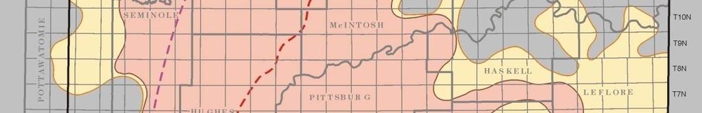
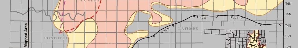
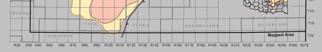
13 Geologic Provinces of Oklahoma The Booch Gas Play
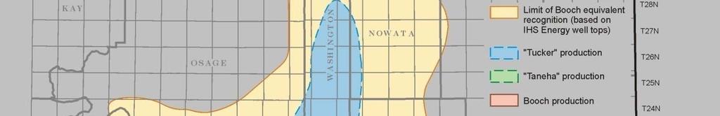
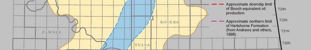
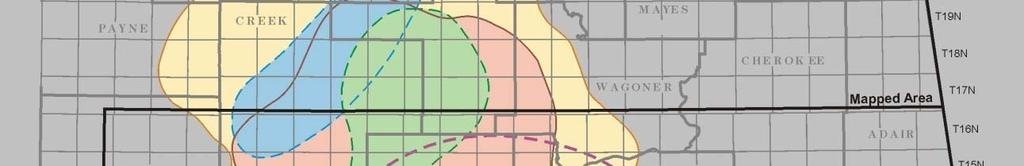
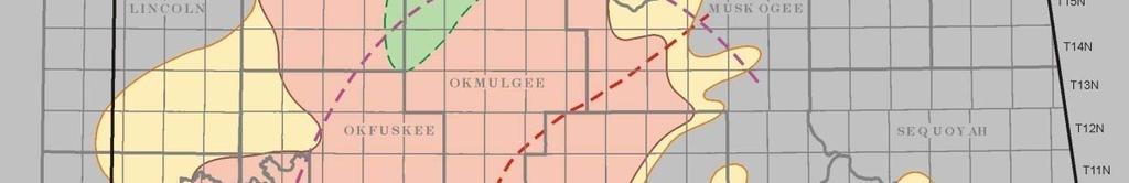
14 Booch-Equivalent Production The Booch Gas Play
15 Regional Data Input The Booch Gas Play


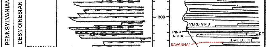
16 Booch Type Log The Booch Gas Play


17 The Booch Gas Play Eustatic Sea Level Curves
18 Booch Schematic Progradational History The Booch Gas Play
19 Booch Stratigraphic Nomenclature The Booch Gas Play
20 Middle Booch Gross Sand Isopach The Booch Gas Play
21 Schematic Middle Booch Depositional Systems The Booch Gas Play
22 Incised Valley Block Diagram The Booch Gas Play
23 Idealized Booch Tidal Delta The Booch Gas Play


")
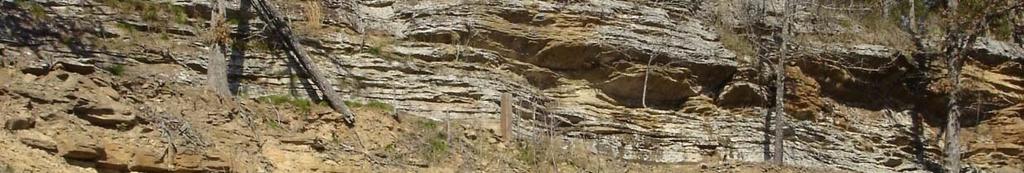
24 The Booch Gas Play Adamson Outcrop PS-1 (Cameron)
25 Herringbone cross-stratification, Adamson Herringbone cross stratification, Adamson outcrop, Cameron Sandstone (PS-1) The Booch Gas Play
26 Herringbone cross-stratification, Adamson Herringbone cross stratification, Adamson outcrop, Cameron Sandstone (PS-1) The Booch Gas Play
27 Flaser bedding, Adamson outcrop, Cameron Sandstone (PS-1) The Booch Gas Play
28 Adamson Outcrop Cameron Sandstone Measured section and gamma-ray profile Note abrupt, erosional base of sandstone Sandstone ~30 ft thick McAlester coal ~150 ft above base of ss
29 Coquina No. 1 Tobe ~1.2 mi NE of outcrop Cameron Sandstone ~80 ft thick Sandstone has abrupt base Base of sandstone ~160 ft below McAlester coal Hartshorne at base of log
30 The Booch Gas Play Interpretation Cameron Sandstone Outcrop X-stratification, ripples high energy flaser beds, herringbone x-strat tidal reworking sharp base lower bar-facies eroded SUM tidally reworked distributary-mouth bar Tobe # 1 Multi-story incised-valley fill BUT ONLY 1.2 MILES FROM OUTCROP!
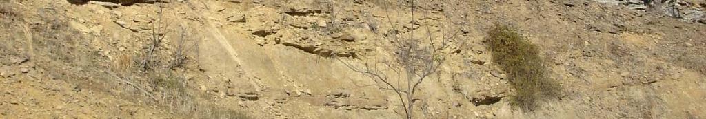
31 New Spiro Lake outcrop, Warner Sandstone (PS 3/3A) The Booch Gas Play

 Section consists of")

32 The Booch Gas Play Graphic Columnar Section, New Spiro Lake outcrop, Warner Sandstone (PS 3/3A) Section consists of two coarsening- upward sequences, typical of distributary-mouth bars
33 Cyclic stratification, New Spiro Lake outcrop, Cyclic stratification, New Spiro Lake outcrop, Warner Sandstone (PS 3/3A) The Booch Gas Play
34 Cyclic stratification, New Spiro Lake outcrop, Cyclic stratification, New Spiro Lake outcrop, Warner Sandstone (PS 3/3A) The Booch Gas Play
35 Cyclic stratification, New Spiro Lake outcrop, Warner Sandstone (PS 3/3A) The Booch Gas Play
36 Cyclic stratification, New Spiro Lake outcrop, Warner Sandstone (PS 3/3A) The Booch Gas Play
37 The Booch Gas Play Interpretation Warner Sandstone A Outcrop Cyclic beds, lenticular and flaser bedding, ss and sh drapes tidal reworking 2 CUSs distributary-mouth bars (two parasequences, especially evident in next outcrop)
38 Panama RR Cut outcrop, Warner Sandstone (PS 3/3A) The Booch Gas Play pennies pennies
39 Cyclic, repetitious stratification, Panama RR Cut Cyclic, repetitious stratification, Panama RR Cut outcrop, Warner Sandstone (PS 3/3A) The Booch Gas Play
40 Draping and flaser bedding, Panama RR Cut outcrop, Warner Sandstone (PS 3/3A) The Booch Gas Play
41 Graphic Columnar Section and Gamma-Ray Profile, Panama RR Cut outcrop, Warner Sandstone (PS 3/3A) The Booch Gas Play Section consists of two upwardcoarsening sequences typical of a distributary- mouth bar separated by a flooding surface
42 The Booch Gas Play Sunwest No Cox Warner Sandstone ~1.5 mi NE of outcrop Warner 2 ss; lower ~8 ft thick, upper ~15 ft thick Both rapidly coarsen upward
43 The Booch Gas Play Outcrop Interpretation Warner Sandstone B Lower sequence lenticular and flaser bedding, drapes tidal reworking Parasequence boundary (also angular unconformity) slumping, dewatering, soft-sediment processes Upper sequence cyclic units, drapes tidal reworking Cap ss, large-scale x-strat high energy distributary channel SUM 2 tidally-reworked DMBs capped by dist channel No Cox 2 thin, rapidly CUSs distributary-mouth bars
44 Carter Lake outcrop, Warner Sandstone (PS-3/3A) The Booch Gas Play
45 Carter Lake outcrop, Warner Sandstone (PS 3/3A) The Booch Gas Play
46 The Booch Gas Play Graphic Columnar Section and Gamma-Ray Profile, Carter Lake outcrop, Warner Sandstone (PS 3/3A) Section shows coarsening-upward sequence. Marine shales at base overlain by distributary-mouth bar. Distributary channel, possibly tidally influenced, at top.
47 The Booch Gas Play AM&S No. 1 Dunn Warner Sandstone ~1.2 mi NW of outcrop Lower sandstone ~15 ft thick; abrupt base Underlying shale coarsens upward
48 The Booch Gas Play Interpretation - Warner Sandstone C Outcrop Dark marine shale at base Ss -little evidence for tidal reworking Cap thick ss, large-scale x-strat tidal or distributary channel CUS distributary-mouth bar No. 1 Dunn 2 sandstones, typical of Warner Lower shale coarsens upward, ss w/ abrupt base distributary-mouth bar eroded by channel
 ( )")

49 Warner Sandstone (?) ( ) Campground Spring Mountain The Booch Gas Play
50 Campground Spring Mountain Warner(?) Sandstone 100+ ft crs- to med-gr porous sandstone, poorly exposed Rip-ups p throughout base Base ~150 ft above Base 150 ft above Hartshorne coal
51 Amoco No. 3 Birckel ~4.5 mi SW of outcrop Ss ~170 ft thick, abrupt base Base ~540 ft above Hartshorne coal Pan Am No. 1 Williams ~4.5 mi SW of outcrop Ss ~225 ft thick, abrupt base Base ~470 ft above Hartshorne coal
52 The Booch Gas Play Interpretation Warner(?) Sandstone Outcrop, No. 3 Birckel, and No. 1 Williams Thick sandstone w/ abrupt base multi-story incised-valley fill BUT WHERE DOES THIS FIT IN TO STRATIGRAPHY AND REGIONAL GEOLOGY???
53 Conclusions Stratigraphy Booch not equivalent to McAlester Surface names correlate w/ subsurface names and tops of parasequences Sequence Stratigraphy Records eight progradational cycles (all sourced from the north) Reservoir Characteristics All are sandstones (occurring near cycle tops) Best are channel-fills Tidally reworked deltaic strata are poorer Can view reservoir types on surface
54
Lower Skinner Valley Fill Sandstones: Attractive Exploration Targets on the Northeast Oklahoma Platform*
 Lower Skinner Valley Fill Sandstones: Attractive Exploration Targets on the Northeast Oklahoma Platform* By Jim Puckette 1 Search and Discovery Article #10050 (2003) *Adapted from presentation to Tulsa
Bulletin of Earth Sciences of Thailand
 Depositional Environments and Stratigraphic Development of the Grand Taman Sari Circuit Outcrop: an Analogue for Transgressive Mahakam Delta Successions Ridha Santika Riadi Petroleum Geoscience Program,
Facies Analysis Of The Reservoir Rocks In The. Sylhet Trough, Bangladesh. Abstract
 Facies Analysis Of The Reservoir Rocks In The Sylhet Trough, Bangladesh Joyanta Dutta Petroleum Geoscience Program, Department of Geology, Faculty of Science, Chulalongkorn University, Bangkok 10330, Thailand
Petrographic Comparison and Contrast of Fluvial and Deltaic Sandstones, Upper Pennsylvanian Oread Cyclothem, NE Oklahoma
 Missouri University of Science and Technology Scholars' Mine Geosciences and Geological and Petroleum Engineering Faculty Research & Creative Works Geosciences and Geological and Petroleum Engineering
Fluid-Mud Deposits of the Lower Jurassic Tilje Formation, Offshore Mid-Norway By Aitor A. Ichaso and Robert W. Dalrymple 1
 Fluid-Mud Deposits of the Lower Jurassic Tilje Formation, Offshore Mid-Norway By Aitor A. Ichaso and Robert W. Dalrymple 1 Search and Discovery Article #50107 (2008) Posted August 10, 2008 *Adapted from
Effects of Tides on Deltaic Deposition: Causes and Responses*
 Effects of Tides on Deltaic Deposition: Causes and Responses* Piret Plink-Bjorklund 1 Search and Discovery Article #50626 (2012)** Posted June 25, 2012 *Adapted from oral presentation at AAPG Annual Convention
Accommodation. Tectonics (local to regional) Subsidence Uplift
 Subsidence Uplift") Accommodation Accommodation varies over time; it is the distance between a reference horizon and the sea surface (i.e. relative sea level). The space to be filled in with sediments or water What are the
Accommodation Accommodation varies over time; it is the distance between a reference horizon and the sea surface (i.e. relative sea level). The space to be filled in with sediments or water What are the
Michael Walsworth, Ryan Sullivan, Simi Odueyungbo, William Budd
 Michael Walsworth, Ryan Sullivan, Simi Odueyungbo, William Budd Estuarine Environment At first (Pritchard, 1967), an estuary was defined by the salinity of the water. Then by Clifton (1982) as an inlet
Glauconitic Oil Reservoirs in Southern Alberta Creating the Correct Geological Model to Guide Development Drilling
 Glauconitic Oil Reservoirs in Southern Alberta Creating the Correct Geological Model to Guide Development Drilling Brad Hayes* Petrel Robertson Consulting Ltd, Calgary, AB bhayes@petrelrob.com Lisa Griffith
GEOL 440 Sedimentology and stratigraphy: processes, environments and deposits Lectures 16 & 17: Deltaic Facies
 GEOL 440 Sedimentology and stratigraphy: processes, environments and deposits Lectures 16 & 17: Deltaic Facies What controls morphology and facies of the Nile Delta? Basic processes Classification Facies
Depositional Sequences Sequences
 Depositional Sequences Transgressive and Regressive packages can be bound by unconformities Because sediment can only be preserved during net aggradation and progradation All other times there is either
Dakota Sandstone. of the Moxa Arch and Surrounding Green River Basin
 Dakota Sandstone of the Moxa Arch and Surrounding Green River Basin Dakota Sandstones of the Green River Basin Overview The Dakota sandstones of the Moxa Arch and surrounding Green River Basin remain attractive
Bulletin of Earth Sciences of Thailand
 Quantitative Seismic Geomorphology of Early Miocene to Pleistocene Fluvial System of Northern Songkhla Basin, Gulf of Thailand Oanh Thi Tran Petroleum Geoscience Program, Department of Geology, Faculty
Data Repository item
 Data Repository (B25407): Localities and descriptions of measured sections of study areas Table 1. Localities of the measured sedimentary sections in the NW Sichuan Basin Section Number Stratigraphy Locality
Steve Cumella 1. Search and Discovery Article # (2009) Posted July 30, Abstract
 Posted July 30, Abstract") AV Geology of the Piceance Basin Mesaverde Gas Accumulation* Steve Cumella 1 Search and Discovery Article #110106 (2009) Posted July 30, 2009 *Adapted from oral presentation at AAPG Annual Convention,
AV Geology of the Piceance Basin Mesaverde Gas Accumulation* Steve Cumella 1 Search and Discovery Article #110106 (2009) Posted July 30, 2009 *Adapted from oral presentation at AAPG Annual Convention,
Chapter 8: Learning objectives
 Chapter 8: Learning objectives Understand concept of sedimentary facies Signinifance of lateral and vertical facies associations Walther s Law Understand the sedimentary facies of alluvial fans, eolian
The Impact of Parasequence Stacking Patterns on Vertical Connectivity Between Wave-Dominated, Shallow Marine Parasequences, Book Cliffs, Eastern Utah
 The Impact of Parasequence Stacking Patterns on Vertical Connectivity Between Wave-Dominated, Shallow Marine Parasequences, Book Cliffs, Eastern Utah MALCOLM J. ARNOT and TIMOTHY R. GOOD* MALCOLM J. ARNOT
GeoCanada 2010 Working with the Earth
 Lithofacies Identification and the Implications for SAGD Well Planning in the McMurray Formation, Christina Lake Area, Alberta Travis Shackleton*, Robert Gardner, Sung Youn, Grace Eng and Lori Barth Cenovus
Reservoir Characterization for the Application of ASP Flood Technology in the Bridgeport Sandstone in Lawrence Field, Illinois*
 Reservoir Characterization for the Application of ASP Flood Technology in the Bridgeport Sandstone in Lawrence Field, Illinois* Nathan D. Webb 1, Vineeth Madhavan 1, John P. Grube 1, Curt S. Blakley 1,
Chapter 4: Sequence Stratigraphy of the Cherokee Group
 Chapter 4: Sequence Stratigraphy of the Cherokee Group 4.1 Sequence Stratigraphic Nomenclature Sequence stratigraphic concepts provide a framework to better explain and predict the lateral distribution,
Nathan D. Webb and James L. Best
 Nathan D. Webb and James L. Best Background Pennsylvanian oil production Stratigraphy & geologic setting Study area Methods Using geophysical logs & core Results Comparing three channel deposits Implications
OUTCROP! CHARACTERISATION! OF! TRANSGRESSIVE! SANDSTONE! RESERVOIRS:! QUANTITATIVE!COMPARISON!OF!OUTCROP!ANALOGUES!
 OUTCROP CHARACTERISATION OF TRANSGRESSIVE SANDSTONE RESERVOIRS: QUANTITATIVECOMPARISONOFOUTCROPANALOGUES OLIVER D. JORDAN 1, PETER J. SIXSMITH 2, GARY J. HAMPSON, SANJEEV GUPTA & HOWARDD.JOHNSON DepartmentofEarthScienceandEngineering,ImperialCollegeLondon,SouthKensington
Image: G. Parker. Presenters: Henry Chan, Kayla Ireland, Mara Morgenstern, Jessica Palmer, Megan Scott
 Image: G. Parker Presenters: Henry Chan, Kayla Ireland, Mara Morgenstern, Jessica Palmer, Megan Scott Is the Ross Formation a suitable analog for sand-rich turbidite plays in passive margin basins? Play:
Outcrops from Every Continent and 20 Countries in 140 Contributions. Tor H. Nilsen, Roger D. Shew, Gary S. Steffens, and Joseph R.J. Studlick.
 Paper VIII Tor H. Nilsen, Roger D. Shew, Gary S. Steffens, and Joseph R.J. Studlick Editors Outcrops from Every Continent and 20 Countries in 140 Contributions http://bookstore.aapg.org Length ~ 23 m (75.5
IDENTIFICATION AND EVALUATION OF FLUVIAL-DOMINATED DELTAIC (CLASS 1 OIL) RESERVOIRS IN OKLAHOMA. YEARLY TECHNICAL PROGRESS REPORT for 1996
 RESERVOIRS IN OKLAHOMA. YEARLY TECHNICAL PROGRESS REPORT for 1996") IDENTIFICATION AND EVALUATION OF FLUVIAL-DOMINATED DELTAIC (CLASS 1 OIL) RESERVOIRS IN OKLAHOMA YEARLY TECHNICAL PROGRESS REPORT for 1996 Report Type: Annual Reporting Period: January 1 - December 31,
IDENTIFICATION AND EVALUATION OF FLUVIAL-DOMINATED DELTAIC (CLASS 1 OIL) RESERVOIRS IN OKLAHOMA YEARLY TECHNICAL PROGRESS REPORT for 1996 Report Type: Annual Reporting Period: January 1 - December 31,
Search and Discovery Article #41255 (2014)** Posted February 11, 2014
** Posted February 11, 2014") Correlating Porosity with Acoustic Impedance in Sandstone Gas Reservoirs: Examples from the Atokan Sandstones of the Arkoma Basin, Southeastern Oklahoma* Ibrahim Çemen 1, Jeff Fuchs 1, Bill Coffey 2, Rodney
Correlating Porosity with Acoustic Impedance in Sandstone Gas Reservoirs: Examples from the Atokan Sandstones of the Arkoma Basin, Southeastern Oklahoma* Ibrahim Çemen 1, Jeff Fuchs 1, Bill Coffey 2, Rodney
Depositional Environments. Depositional Environments
 Depositional Environments Geographic area in which sediment is deposited Characterized by a combination of geological process & environmental conditions Depositional Environments Geological processes:
Lab 8: Facies Analysis and Correlations: Sequence Stratigraphy in the Book Cliffs, Utah
 Geology 109L Lab 8: Facies Analysis and Correlations: Sequence Stratigraphy in the Book Cliffs, Utah Goal: In this lab, you will put together your knowledge of near-shore facies and sequence stratigraphy
PROCEEDINGS, INDONESIAN PETROLEUM ASSOCIATION Forty-First Annual Convention & Exhibition, May 2017
 IPA17-369-SG PROCEEDINGS, INDONESIAN PETROLEUM ASSOCIATION Forty-First Annual Convention & Exhibition, May 2017 FACIES ANALYSIS OF LATE NEOGENE DEPOSIT: MARINE TO CONTINENTAL ENVIRONMENT OF THE MERAPI
Minnelusa Play: The impact of tectonics and an ancient dune field on production
 Minnelusa Play: The impact of tectonics and an ancient dune field on production Steven G. Fryberger ENHANCED OIL RECOVERY INSTITUTE Permian Tectonic Map of Wyoming 200 miles after Inden, et al, 1996 PermoPennsylvanian
Cretaceous USM Reservoir, F-O Gas Field, Offshore South Africa: Sedimentological Factors Affecting Economic Viability*
 Cretaceous USM Reservoir, F-O Gas Field, Offshore South Africa: Sedimentological Factors Affecting Economic Viability* Roger Higgs 1 Search and Discovery Article #20072 (2009) Posted May 20, 2009 *Adapted
Case Study of the Structural and Depositional-Evolution Interpretation from Seismic Data*
 Case Study of the Structural and Depositional-Evolution Interpretation from Seismic Data* Yun Ling 1, Xiangyu Guo 1, Jixiang Lin 1, and Desheng Sun 1 Search and Discovery Article #20143 (2012) Posted April
Sedimentary and Stratigraphic Analysis of the Viking Sand in the Edgerton/Wainwright Area, Central Alberta* By Russell Walz 1
 Sedimentary and Stratigraphic Analysis of the Viking Sand in the Edgerton/Wainwright Area, Central Alberta* By Russell Walz 1 Search and Discovery Article #50030 (2006) Posted June 25, 2006 *Extended abstract
Facies Analysis of the Lower Cretaceous Wilrich Member (Lower Falher) of the Spirit River Formation.
 of the Spirit River Formation.") Facies Analysis of the Lower Cretaceous Wilrich Member (Lower Falher) of the Spirit River Formation. Kerrie L. Bann, Ichnofacies Analysis Inc. and Daniel J. K. Ross, Tourmaline Oil Corp. Historically,
Facies Analysis of the Lower Cretaceous Wilrich Member (Lower Falher) of the Spirit River Formation. Kerrie L. Bann, Ichnofacies Analysis Inc. and Daniel J. K. Ross, Tourmaline Oil Corp. Historically,
Coalbed Methane: Louisiana s Unexplored Energy Resource
 BRI Bulletin 1 Coalbed Methane: Louisiana s Unexplored Energy Resource John B. Echols 1 Abstract The Central Louisiana Coalbed Methane Basin (CELCOM) is part of a much larger coalbed methane basin, the
Contents. Introduction. Introduction. Modern Environments. Tools for Stratigraphic Analysis
 Contents Tools for Stratigraphic Analysis Introduction of Study: Modern Environments of Study: Ancient Deposits Summary Introduction Basin analysts use a variety of methods to study modern and ancient
Chapter 5. The Sedimentary Archives
 Chapter 5 The Sedimentary Archives Factors affecting Sedimentary Characteristics 1. Tectonic setting 2. Physical, chemical, and biological processes in the depositional environment 3. Method of sediment
Stochastic Simulation of Inclined Heterolithic Stratification with Streamline-based Stochastic Models
 Stochastic Simulation of Inclined Heterolithic Stratification with Streamline-based Stochastic Models Michael J. Pyrcz and Clayton V. Deutsch Department of Civil and Environmental Engineering, University
Lecture 19: Fluvial Facies
 GEOL 440 Sedimentology and stratigraphy: processes, environments and deposits Lecture 19: Fluvial Facies Aims Examine controls on alluvial channel pattern List the types of channel pattern Examine meandering
High-resolution Sequence Stratigraphy of the Glauconitic Sandstone, Upper Mannville C Pool, Cessford Field: a Record of Evolving Accommodation
 Page No. 069-1 High-resolution Sequence Stratigraphy of the Glauconitic Sandstone, Upper Mannville C Pool, Cessford Field: a Record of Evolving Accommodation Thérèse Lynch* and John Hopkins, Department
CLASTICS FIELD TRIP. Dynamic stratigraphy, facies, architecture and fracture analysis of coastal depositional systems
 CLASTICS FIELD TRIP Dynamic stratigraphy, facies, architecture and fracture analysis of coastal depositional systems MAY 2-5 SEPTEMBER 17-20, 2018 Appraisal and development of clastic reservoirs rely on
Bulletin of Earth Sciences of Thailand. Controls on Reservoir Geometry and Distribution, Tantawan Field, Gulf of Thailand.
 Controls on Reservoir Geometry and Distribution, Tantawan Field, Gulf of Thailand Atchara Praidee Petroleum Geoscience Program, Department of Geology, Faculty of Science, Chulalongkorn University, Bangkok
Evidence of a Sandy Suspended-Load Dominated River from the Mississippian Cypress Formation, Illinois, USA
 Evidence of a Sandy Suspended-Load Dominated River from the Mississippian Cypress Formation, Illinois, USA Kalin Howell 1, Nathan Webb 2, Jim Best 1,3, Eric Prokocki 1,4 1 Department of Geology, University
Sediment and sedimentary rocks Sediment
 Sediment and sedimentary rocks Sediment From sediments to sedimentary rocks (transportation, deposition, preservation and lithification) Types of sedimentary rocks (clastic, chemical and organic) Sedimentary
Stratigraphic Analysis with Respect to Aggregate Potential in the Duffield Quarry in Gum Log, Arkansas
 University of Arkansas, Fayetteville ScholarWorks@UARK Theses and Dissertations 5-2015 Stratigraphic Analysis with Respect to Aggregate Potential in the Duffield Quarry in Gum Log, Arkansas Brock Evan
LOWER GRAND RAPIDS BITUMEN POOLS AT COLD LAKE, ALBERTA VARIATIONS IN STRATIGRAPHIC SETTING AND DEPOSITIONAL ENVIRONMENTS
 RAPIDS BITUMEN POOLS AT COLD LAKE, ALBERTA VARIATIONS IN STRATIGRAPHIC SETTING AND DEPOSITIONAL ENVIRONMENTS Brad J. Hayes, Petrel Robertson Consulting Ltd. Garrett M. Quinn, OSUM Oil Sands Corp. Summary
Dalhousie University- Petroleum Geoscience Field Methods- Trinidad Summary Report
 Dalhousie University- Petroleum Geoscience Field Methods- Trinidad Summary Report Submitted to: Offshore Energy Research Association of Nova Scotia (OERA) To fulfill requirements of the Undergraduate Student
BACKGROUND GEOLOGY. Hoaglund 1. Wichita Orogeny to the south (10k 15k uplift) Rapid erosion and deposition of uplifted granitic basement rock ~18,000
 Rapid erosion and deposition of uplifted granitic basement rock ~18,000") POST APPRAISAL OF THE MISSOURIAN HOGSHOOTER HYDROCARBON SYSTEM: IMPLICATIONS FOR FUTURE EXPLOITATION IN THE ANADARKO BASIN STEVE HOAGLUND (GEOLOGIST CHESAPEAKE ENERGY) BACKGROUND GEOLOGY Wichita Orogeny
POST APPRAISAL OF THE MISSOURIAN HOGSHOOTER HYDROCARBON SYSTEM: IMPLICATIONS FOR FUTURE EXPLOITATION IN THE ANADARKO BASIN STEVE HOAGLUND (GEOLOGIST CHESAPEAKE ENERGY) BACKGROUND GEOLOGY Wichita Orogeny
Seismic Stratigraphy of the Fang Basin, Chiang Mai, Thailand Rungsun Nuntajun
 Chiang Mai J. Sci. 2009; 36(1) 77 Chiang Mai J. Sci. 2009; 36(1) : 77-82 www.science.cmu.ac.th/journal-science/josci.html Contributed Paper Seismic Stratigraphy of the Fang Basin, Chiang Mai, Thailand
Deep Water Systems and Sequence Stratigraphy. By: Matt Kyrias, Chris Majerczyk, Nick Whitcomb, Wesley Vermillion
 Deep Water Systems and Sequence Stratigraphy By: Matt Kyrias, Chris Majerczyk, Nick Whitcomb, Wesley Vermillion Contents Gravity Flow Depositional Elements Defined References NOTE: Source uses seismic
EROSION, DEPOSITION AND SEDIMENTARY ROCKS. Reading: Earth Science Tarbuck and Lutgens Chapter 5: pages Chapter 3: pages 52-54, 61-69
 EROSION, DEPOSITION AND SEDIMENTARY ROCKS Reading: Earth Science Tarbuck and Lutgens Chapter 5: pages 124-133 Chapter 3: pages 52-54, 61-69 Base Level Resistant bed Resistant bed creates a local base level
Search and Discovery Article #20097 (2011) Posted January 31, 2011
 Posted January 31, 2011") Integrated Geological and Engineering Studies in Support of Producing Light Oil from a Frozen Reservoir: A Case Study from Umiat Oil Field, Northern Alaska* C. Hanks 1, J. Mongrain 2, A. Dandekar 2, P.
Integrated Geological and Engineering Studies in Support of Producing Light Oil from a Frozen Reservoir: A Case Study from Umiat Oil Field, Northern Alaska* C. Hanks 1, J. Mongrain 2, A. Dandekar 2, P.
Geology of the Gull Lake North ASP Flood, Upper Shaunavon Formation, Southwest Saskatchewan
 Geology of the Gull Lake North ASP Flood, Upper Shaunavon Formation, Southwest Saskatchewan By Sid Leggett, Husky Energy (sid.leggett@huskyenergy.com) Acknowledgements Husky Energy Members of the Gull
Sequence Stratigraphy: An Applied Workshop
 Sequence Stratigraphy: An Applied Workshop Instructor: Prof. Octavian Catuneanu Level: Intermediate Duration: 5 days Course Description and Objectives This workshop presents the concepts and practical
Apache Egypt Companies. The introduction of 3D seismic techniques three decades ago greatly enhanced our
 Structure architecture interpretation of the middle Frio Formation using 3D seismic attributes and well logs: an example from the Texas Gulf Coast of the United States HAMED EL-MOWAFY 1 and KURT J. MARFURT
Structural Framework and Deep-Marine Depositional Environments of Miocene- Pleistocene Sequence in Western Offshore Myanmar
 P-58 Structural Framework and Deep-Marine Depositional Environments of Miocene- Pleistocene Sequence in Western Offshore Myanmar Mukesh Jain*, Prabal Shankar Das, Bidesh Bandyopadhyay Summary The western
Petrophysical Analysis and Sequence Stratigraphy Appraisal from Well logs of Bobo field, South-Eastern, Niger Delta
 Journal of Emerging Trends in Engineering and Applied Sciences (JETEAS) 4(2): 219-225 Scholarlink Research Institute Journals, 2013 (ISSN: 2141-7016) jeteas.scholarlinkresearch.org Journal of Emerging
Sedimentary rocks. Mechanical Weathering. Weathering. Chemical weathering. Rates of weathering. Fossil Fuel Resources. Two kinds of weathering
 Sedimentary rocks Fossil Fuel Resources Exam next Tuesday February 14 Bring Scantron and Review Questions About 75% of all rock outcrops on the continents Important to reconstruct much of Earth's history
Sequence Stratigraphy of the Upper Cretaceous Niobrara Formation, A Bench, Wattenberg Field, Denver Julesburg Basin, Colorado*
 Sequence Stratigraphy of the Upper Cretaceous Niobrara Formation, A Bench, Wattenberg Field, Denver Julesburg Basin, Colorado* Lisa E. Remington LaChance 1 and Mark C. Robinson 1 Search and Discovery Article
3D geological model for a gas-saturated reservoir based on simultaneous deterministic partial stack inversion.
 first break volume 28, June 2010 special topic A New Spring for Geoscience 3D geological model for a gas-saturated reservoir based on simultaneous deterministic partial stack inversion. I. Yakovlev, Y.
Understanding Earth Fifth Edition
 Understanding Earth Fifth Edition Grotzinger Jordan Press Siever Chapter 5: SEDIMENTATION: Rocks Formed by Surface Processes Lecturer: H Mohammadzadeh Assistant professors, Department of Geology, FUM Copyright
Modeling Lateral Accretion in McMurray Formation Fluvial- Estuarine Channel Systems: Grizzly Oil Sands May River SAGD Project, Athabasca
 Modeling Lateral Accretion in McMurray Formation Fluvial- Estuarine Channel Systems: Grizzly Oil Sands May River SAGD Project, Athabasca Duncan Findlay, Thomas Nardin, Alex Wright, Raheleh Salehi Mojarad
Sedimentology and Stratigraphy of Lower Smackover Tight Oil Carbonates: Key to Predictive Understanding of Reservoir Quality and Distribution
 Integrated Reservoir Solutions Sedimentology and Stratigraphy of Lower Smackover Tight Oil Carbonates: Key to Predictive Understanding of Reservoir Quality and Distribution Roger J. Barnaby Presented at
11/22/2010. Groundwater in Unconsolidated Deposits. Alluvial (fluvial) deposits. - consist of gravel, sand, silt and clay
 deposits. - consist of gravel, sand, silt and clay") Groundwater in Unconsolidated Deposits Alluvial (fluvial) deposits - consist of gravel, sand, silt and clay - laid down by physical processes in rivers and flood plains - major sources for water supplies
Groundwater in Unconsolidated Deposits Alluvial (fluvial) deposits - consist of gravel, sand, silt and clay - laid down by physical processes in rivers and flood plains - major sources for water supplies
Modeling of Intra-Channel Belt Depositional Architecture in Fluvial Reservoir Analogs from the Lourinha Formation, Portugal*
 Modeling of Intra-Channel Belt Depositional Architecture in Fluvial Reservoir Analogs from the Lourinha Formation, Portugal* Anneli Ekeland 1, Nina Pedersen 1, John Howell 1, Wojtek Nemec 2, Kevin Keogh
AAPG Search and Discovery Article #90173 CSPG/CSEG/CWLS GeoConvention 2011, Calgary, Alberta, Canada, May 9-11, 2011
 Use of Image Logs in Differentiating Point Bar and Tidal Bar Deposits in the Leismer Area: Implications for SAGD Reservoir Definition in the Athabasca Oilsands Howard Brekke and Andrew Couch Introduction
3rd-order sequence stratigraphy and lithostratigraphy of the Bearpaw Horseshoe Canyon transition, Alberta plains
 3rd-order sequence stratigraphy and lithostratigraphy of the Bearpaw Horseshoe Canyon transition, Alberta plains Ben Hathway, Alberta Geological Survey, Alberta Energy Regulator, Edmonton, Alberta, ben.hathway@aer.ca
Meandering Miocene Deep Sea Channel Systems Offshore Congo, West Africa
 Meandering Miocene Deep Sea Channel Systems Offshore Congo, West Africa S. Baer* (PGS), J. E. Comstock (PGS), K. Vrålstad (PGS), R. Borsato (PGS), M. Martin (PGS), J.P. Saba (SNPC), B. Débi-Obambé (SNPC)
Relationship between River-mouth Depositional Processes and Delta Architectures, Huangqihai Lake, Inner Mongolia, North China*
 Relationship between River-mouth Depositional Processes and Delta Architectures, Huangqihai Lake, Inner Mongolia, North China* Shunli Li 1,3, Xinghe Yu 2, Shengli Li 2, Cornel Olariu 3, and Ronald Steel
What is a sedimentary rock?
 Sedimentary Rocks What is a sedimentary rock? Sedimentary rocks are products of mechanical and chemical weathering They account for only 5% of the top 10 miles of the outer crust, yet most of the earth
Appraising a late-middle-aged Brent Group field
 Appraising a late-middle-aged Brent Group field Reservoir learnings after nearly 20 years of Pelican field production Jill Marriott The Pelican Field The Pelican oil field is nearly 20 years old It is
Holocene Sediments of the Rhine-Meuse-Scheldt Estuaries as Aids to Interpret Tidal and Fluvial-Tidal Deposits in Outcrop and Core*
 Holocene Sediments of the Rhine-Meuse-Scheldt Estuaries as Aids to Interpret Tidal and Fluvial-Tidal Deposits in Outcrop and Core* Allard W. Martinius 1 and J.H. (Janrik) van den Berg 2 Search and Discovery
Southern Songkhla Basin, Gulf of Thailand
 Architecture and Depositional Environment of Fluvial Systems of Southern Songkhla Basin, Gulf of Thailand Toan Manh Do Petroleum Geoscience Program, Department of Geology, Faculty of Science, Chulalongkorn
The 3-D Seismic Geomorphology of Deep-Water Slope Channel Systems A Case Study from the Deep Water Nile Delta
 Geological Society of Trinidad & Tobago The 3-D Seismic Geomorphology of Deep-Water Slope Channel Systems A Case Study from the Deep Water Nile Delta Nigel E. Cross Presentation Outline Introduction Deep
Improved Oil Recovery in the Cypress Using an Unconventional Approach
 Improved Oil Recovery in the Cypress Using an Unconventional Approach Nathan D. Webb IOGA Annual Convention March 2, 2017 2 Acknowledgments Project Co-PIs Scott Frailey Hannes Leetaru Geology Nathan Webb
Seismic Attributes and Their Applications in Seismic Geomorphology
 Academic article Seismic Attributes and Their Applications in Seismic Geomorphology Sanhasuk Koson, Piyaphong Chenrai* and Montri Choowong Department of Geology, Faculty of Science, Chulalongkorn University,
Issues Related to Oklahoma Coalbed- Methane Activity,
 Figure 1. Map of the eastern Oklahoma coalfield (modified from Friedman, 1974). Issues Related to Oklahoma Coalbed- Methane Activity, 1988 2008 Brian J. Cardott Oklahoma Geological Survey INTRODUCTION
Prof Bryan T CRONIN Principal Geologist 2 Tullow Ghana Ltd
 Entrenched slope channel complex systems: Reservoir opportunities through understanding architectural element distribution and application to West Africa E&P Prof Bryan T CRONIN Principal Geologist 2 Tullow
Anatomy of a Fluvial to Estuarine Valley Fill, North Cactus Lake McLaren Reservoir
 Anatomy of a Fluvial to Estuarine Valley Fill, North Cactus Lake McLaren Reservoir J. Edward Mathison Alethia Geologica, Filling of the north Cactus Lake post Waseca paleovalley, during McLaren sea level
Overview of Selected Shale Plays in New Mexico*
 Overview of Selected Shale Plays in New Mexico* Ron Broadhead 1 Search and Discovery Article #10627 (2014)** Posted August 18, 2014 *Adapted from presentation at RMAG luncheon meeting, Denver, Colorado,
NOTICE AND DISCLAIMER
 NOTICE AND DISCLAIMER The information contained herein and/or these workshop/seminar proceedings (WORK) was prepared by or contributed to by various parties in support of professional continuing education.
Sequence Stratigraphic Analysis from Well Logs of an X- Field, Niger Delta, Nigeria
 Current Research in Geosciences Original Research Paper Sequence Stratigraphic Analysis from Well Logs of an X- Field, Niger Delta, Nigeria Godwin Omokenu Emujakporue and Alphonsus Joseph Eyo Department
Sequence Stratigraphic Framework and Reservoir Architecture of the Lingshui-3 Member, Yacheng 13-1 Gas Field, South China Sea
 Sequence Stratigraphic Framework and Reservoir Architecture of the Lingshui-3 Member, Yacheng 13-1 Gas Field, South China Sea David Z. Tang BP China Exploration and Production Company 17/F, Finance Centre,
Sedimentary Geology Earth and Planetary Sciences Final Exam December Duration 3 Hours
 Sedimentary Geology Earth and Planetary Sciences 186-455 Final Exam December 2005 Duration 3 Hours General instructions: 1) All answers must be written in answer books provided and turned in at the end
Modeling Lateral Accretion in McMurray Formation Fluvial-Estuarine Channel Systems: Grizzly Oil Sands May River SAGD Project, Athabasca*
 Modeling Lateral Accretion in McMurray Formation Fluvial-Estuarine Channel Systems: Grizzly Oil Sands May River SAGD Project, Athabasca* Duncan Findlay 1, Thomas Nardin 1, Alex Wright 1, and Raheleh Salehi
Lecture Outline Wednesday - Friday February 14-16, 2018
 Lecture Outline Wednesday - Friday February 14-16, 2018 Quiz 2 scheduled for Friday Feb 23 (Interlude B, Chapters 6,7) Questions? Chapter 6 Pages of the Past: Sedimentary Rocks Key Points for today Be
Seismic stratigraphy, some examples from Indian Ocean, interpretation of reflection data in interactive mode
 Seismic stratigraphy, some examples from Indian Ocean, interpretation of reflection data in interactive mode K. S. Krishna National Institute of Oceanography, Dona Paula, Goa-403 004. krishna@nio.org Seismic
Controls on clastic systems in the Angoche basin, Mozambique: tectonics, contourites and petroleum systems
 P2-2-13 Controls on clastic systems in the Angoche basin, Mozambique: tectonics, contourites and petroleum systems Eva Hollebeek, Olivia Osicki, Duplo Kornpihl Schlumberger, London, UK Introduction Offshore
4.1 Sediment accommodation space principles and controls
 58 The sedimentary record of sea-level change 4. Sediment accommodation space principles and controls Sequence stratigraphy emphasizes the importance of the space that is made available within a basin
Continental Environments. Continental Environments. Chapter 9. Deserts Alluvial fans Rivers (fluvial) and floodplains Lakes (lacustrine) Glacial
 and floodplains Lakes (lacustrine) Glacial") Continental Environments Chapter 9 Continental Environments Deserts Alluvial fans Rivers (fluvial) and floodplains Lakes (lacustrine) Glacial Desert Biome http://www.blueplanetbiomes.org/climate.htm low-latitude
Continental Environments Chapter 9 Continental Environments Deserts Alluvial fans Rivers (fluvial) and floodplains Lakes (lacustrine) Glacial Desert Biome http://www.blueplanetbiomes.org/climate.htm low-latitude
Viking Lowstand Deposits in West Central Saskatchewan: Depositional Model for the Reservoir Units in Dodsland-Hoosier Area, Saskatchewan, Canada
 Viking Lowstand Deposits in West Central Saskatchewan: Depositional Model for the Reservoir Units in Dodsland-Hoosier Area, Saskatchewan, Canada Hasan Ferdous* PetroSed Geoconsulting Resources, Calgary,
The Late Tertiary Deep-Water Siliciclastic System of the Levant Margin - An Emerging Play Offshore Israel*
 The Late Tertiary Deep-Water Siliciclastic System of the Levant Margin - An Emerging Play Offshore Israel* Michael A. Gardosh 1, Yehezkel Druckman 2 and Binyamin Buchbinder 2 Search and Discovery Article
Search and Discovery Article #40536 (2010) Posted June 21, 2010
 Posted June 21, 2010") Modern Examples of Mass Transport Complexes, Debrite and Turbidite Associations: Geometry, Stratigraphic Relationships and Implications for Hydrocarbon Trap Development* Fabiano Gamberi 1, Marzia Rovere
Modern Examples of Mass Transport Complexes, Debrite and Turbidite Associations: Geometry, Stratigraphic Relationships and Implications for Hydrocarbon Trap Development* Fabiano Gamberi 1, Marzia Rovere
SUPPLEMENTAL INFORMATION DELFT 3-D MODELING: MODEL DESIGN, SETUP, AND ANALYSIS
 GSA DATA REPOSITORY 2014069 Hajek and Edmonds SUPPLEMENTAL INFORMATION DELFT 3-D MODELING: MODEL DESIGN, SETUP, AND ANALYSIS Each experiment starts from the initial condition of a straight channel 10 km
Lab 7: Sedimentary Structures
 Name: Lab 7: Sedimentary Structures Sedimentary rocks account for a negligibly small fraction of Earth s mass, yet they are commonly encountered because the processes that form them are ubiquitous in the
A Simplified Guide For Sequence Stratigraphy:
 SEPM Society for Sedimentary Geology A Simplified Guide For Sequence Stratigraphy: Nomenclature, Definitions and Method Vitor Abreu President - SEPM Abstract All attempts to codify Sequence Stratigraphy
2003 GCSSEPM Foundation Ed Picou Fellowship Grant for Graduate Studies in the Earth Sciences Recipient
 2003 GCSSEPM Foundation Ed Picou Fellowship Grant for Graduate Studies in the Earth Sciences Recipient Tarek A. El Shayeb University of Texas at Austin Integrated reservoir characterization and 3-D diagenetic
ES120 Sedimentology/Stratigraphy
 Midterm Exam 5/05/08 NAME: 1. List or describe 3 physical processes that contribute to the weathering of rocks (3pts). exfoliation frost wedging many others. roots, thermal expansion/contraction also credit
Depositional History and Petroleum Potential of Ombilin Basin, West Sumatra - Indonesia, Based on Surface Geological Data*
 Depositional History and Petroleum Potential of Ombilin Basin, West Sumatra - Indonesia, Based on Surface Geological Data* Yahdi Zaim 1, Litto Habrianta 2, Chalid I. Abdullah 1, Aswan 1, Yan Rizal 1, Nurcahyo
The Hydrologic Cycle
 CONTINENTAL DEPOSITIONAL ENVIRONMENTS fluvial desert lacustrine (lake) Glacial KEY PARAMETERS (VARIABLES) 1. Climate (Hydrologic Cycle) Annual Precip vs. Seasonality 2. Tectonics (Mountains) The Hydrologic