Glauconitic Oil Reservoirs in Southern Alberta Creating the Correct Geological Model to Guide Development Drilling
|
|
|
- Lawrence Stevenson
- 6 years ago
- Views:
Transcription
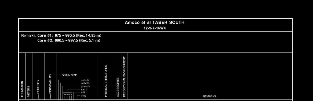
1 Glauconitic Oil Reservoirs in Southern Alberta Creating the Correct Geological Model to Guide Development Drilling Brad Hayes* Petrel Robertson Consulting Ltd, Calgary, AB Lisa Griffith Griffith Geoconsulting Inc, Calgary, AB, Canada and John Carey Petrel Robertson Consulting Ltd, Calgary, AB, Canada Summary Many oil fields in southern Alberta produce from the Glauconitic member of the Upper Mannville Formation. Examination of core and detailed mapping reveal important stratigraphic differences among these reservoirs, and show that some do not belong to the Glauconitic at all. Understanding these differences is critical in efficient modeling and development of full productive potential. In this core display, we contrast a true Glauconitic reservoir at Taber South with the Medicine Hat Glauconitic reservoir which actually belongs to the Basal Quartz. Glauconitic Member Stratigraphy and Distribution Sherwin (1996) mapped Glauconitic valley trends from Township 14 north to the Hoadley and Pembina Barriers (Township 50), which delineate a basin-scale drainage system, flowing northward to the Boreal Sea. Petrel Robertson Consulting Ltd. (1998) extended regional Glauconitic valley trend mapping southward through Taber, Taber South, Wrentham, and Philp to the Montana border. Notably, Glauconitic valley trends have not been mapped into the Medicine Hat area of southeastern Alberta, where Smith (1994) documented Mannville thinning across the Medicine Hat - Swift Current Highlands. Glauconitic valleys were filled as sea level rose during mid-mannville transgression of the Wilrich / Clearwater sea. High-quality reservoirs were deposited as clean, sublithic estuarine valley-fill sandstones, sealed by equivalent estuarine muds. Several generations of younger Upper Mannville fluvial valley-fill sandstones, exhibiting a distinct volcanic / feldspathic composition and poor reservoir quality, dissect the Glauconitic. Focused studies of several Glauconitic oil pools in southern Alberta document estuarine valley-fill environments, and map out reservoir stratigraphy in intricate detail. A series of papers by Wood and
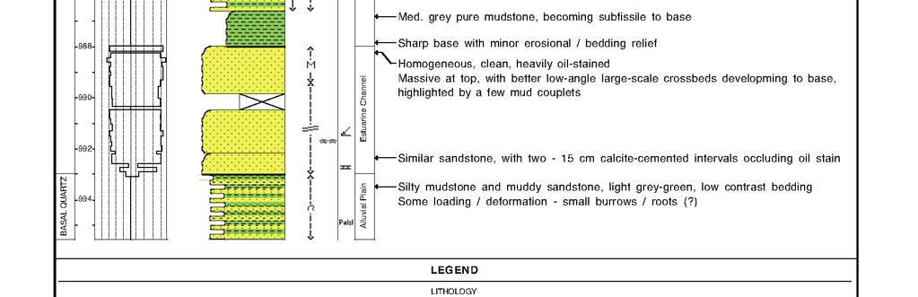
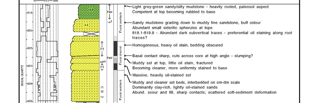
2 Hopkins at Little Bow (Twp , Rge W4), building upon Wood and Hopkins (1989), is an excellent example. Taber South Glauconitic Reservoirs At Wrentham / Taber South (Twp. 6-7, Rge W4), a major northward-trending Glauconitic valley hosts several medium-gravity oil pools. However, they are not clearly distinguished in the official pool nomenclature from older Cut Bank / Basal Quartz reservoirs, which are incised locally by Glauconitic valleys. Core from W4 (Fig. 1) illustrates a well-developed Glauconitic reservoir succession. Estuarine channel sandstones exhibiting mud couplets and flaser bedding lie sharply on the basal contact. They are truncated sharply by middle estuarine mudstones grading up to heterolithic sandstone/shale with soft-sediment deformation and locally intense bioturbation. Near the top of the core, these strata grade upward into estuarine shoal sandstones, within which flaser bedding highlights stacked ripple sets. Glauconitic sandstones are clean, fine- to medium-grained sublitharenites, exhibiting excellent reservoir quality. Detailed mapping demonstrates substantial lateral continuity of specific estuarine channel and shoal reservoir elements, particularly where individual sandstone bodies range up to 10 metres thick (Petrel Robertson, 1998). Cumulative production of more than one million barrels of oil from individual wells is a good indicator of substantial drainage areas and reservoir continuity. Medicine Hat Glauconitic Reservoir Core from 02/ W4 (Fig. 2) illustrates a typical Glauconitic reservoir at Medicine Hat. The 13-metre reservoir section consists of several stacked, metre-scale fining-upward successions. A typical unit lies on a sharp, scoured base, and consists of clean, medium-grained, cross-bedded litharenite, grading upward to finer sandstones with more matrix clays and thin light green-grey mud beds and/or thin, angular mud clasts. A fully-developed succession may be capped by a sandy mudstone with root traces, interpreted as a paleosol. Estuarine facies such as those observed at Taber South and Little Bow tidal channels, burrowed shales and heterolithic successions, and sandier-upward shoals are conspicuously absent. Correlation of individual depositional units from well to well is very difficult. Cumulative production from individual wellbores, while influenced by many operational factors such as reservoir management, well density, and length of time on production, is generally fairly low, suggesting that only limited reservoir volumes are being drained. Thus, reservoir facies and regional paleogeography both argue against the Medicine Hat Glauconitic C pool having been deposited as a true Glauconitic valley fill reservoir. Instead, we suggest deposition occurred as thin, stacked fluvial sandstones in a more continental setting. Zaitlin et al (2002) described these facies as components of the Mesa Incised Valley subdivision of the Basal Quartz member, and mapped a regional north-south Mesa I.V. trend through the Medicine Hat area. We conclude that the Medicine Hat Glauconitic C pool is thus better assigned to the Basal Quartz. Reservoir Continuity and Development Planning Implications Despite intensive development drilling to date at both Taber South and Medicine Hat, considerable scope remains to further optimize recovery. At Taber South, recognition of discrete facies assemblages with predictable vertical and lateral reservoir quality distributions within the Glauconitic can guide reservoir mapping. Production
3 histories of individual wells add valuable information about reservoir body size and drainage efficiency. Detailed mapping, best done within the framework of a well-constructed geological model incorporating a substantial degree of geological interpretation (i.e., predictive facies mapping), would support targeted drilling to optimize reservoir exploitation. At Medicine Hat, stacked Basal Quartz fluvial sandstone bodies have very poor lateral and vertical continuity. Individual reservoir sandstones were deposited in metre-scale beds over limited areas, and capping paleosols further isolate reservoir-quality sandstones. Thus, the geocellular model we build of this reservoir exhibits abrupt vertical and lateral variations in reservoir quality. distributed on the basis of geostatistics, rather than imposed by specific facies concepts. Acknowledgements This project arose from construction of a geological reservoir model of the Medicine Hat Glauconitic C Pool by Petrel Robertson Consulting Ltd., for Enerplus Resources Fund and their partner, the City of Medicine Hat. We thank Enerplus, the City of Medicine Hat, and PRCL for providing resources and permission to publish. References Petrel Robertson Consulting Ltd., Mannville and Jurassic petroleum geology of the Chin Coulee Area, south-central Alberta. Non-exclusive report. Sherwin, M.D., Channel trends in the Glauconitic Member, southern Alberta. Bulletin of Canadian Petroleum Geology, v. 44, #3, p Smith, D.G., Foreland Basin. In: Geological Atlas of the Western Canada Sedimentary Basin, edited by G.D. Mossop and I. Shetsen. Calgary, Canadian Society of Petroleum Geologists / Alberta Research Council. Wood, J.M. and J.C. Hopkins, Reservoir sandstone bodies in estuarine valley fill, Lower Cretaceous Glauconitic Member, Little Bow Field, Alberta, Canada. American Association of Petroleum Geologists Bulletin, v. 73, p Zaitlin, B.A., M.J. Warren, D. Potocki, L. Rosenthal, and R. Boyd, Depositional styles in a low accommodation foreland basin setting: an example from the Basal Quartz (Lower Cretaceous), southern Alberta. Bulletin of Canadian Petroleum Geology, v. 50, #1, p

4
5
High-resolution Sequence Stratigraphy of the Glauconitic Sandstone, Upper Mannville C Pool, Cessford Field: a Record of Evolving Accommodation
 Page No. 069-1 High-resolution Sequence Stratigraphy of the Glauconitic Sandstone, Upper Mannville C Pool, Cessford Field: a Record of Evolving Accommodation Thérèse Lynch* and John Hopkins, Department
LOWER GRAND RAPIDS BITUMEN POOLS AT COLD LAKE, ALBERTA VARIATIONS IN STRATIGRAPHIC SETTING AND DEPOSITIONAL ENVIRONMENTS
 RAPIDS BITUMEN POOLS AT COLD LAKE, ALBERTA VARIATIONS IN STRATIGRAPHIC SETTING AND DEPOSITIONAL ENVIRONMENTS Brad J. Hayes, Petrel Robertson Consulting Ltd. Garrett M. Quinn, OSUM Oil Sands Corp. Summary
GeoCanada 2010 Working with the Earth
 Lithofacies Identification and the Implications for SAGD Well Planning in the McMurray Formation, Christina Lake Area, Alberta Travis Shackleton*, Robert Gardner, Sung Youn, Grace Eng and Lori Barth Cenovus
NXT Energy Solutions Inc.
 SFD Case Example:, Western Canada (Stratigraphic Trapping) Lower Cretaceous Fluvial channel system of the Mannville Group is one of the most prolific hydrocarbon bearing strata in the province of Alberta.
Anatomy of a Fluvial to Estuarine Valley Fill, North Cactus Lake McLaren Reservoir
 Anatomy of a Fluvial to Estuarine Valley Fill, North Cactus Lake McLaren Reservoir J. Edward Mathison Alethia Geologica, Filling of the north Cactus Lake post Waseca paleovalley, during McLaren sea level
Sedimentary and Stratigraphic Analysis of the Viking Sand in the Edgerton/Wainwright Area, Central Alberta* By Russell Walz 1
 Sedimentary and Stratigraphic Analysis of the Viking Sand in the Edgerton/Wainwright Area, Central Alberta* By Russell Walz 1 Search and Discovery Article #50030 (2006) Posted June 25, 2006 *Extended abstract
Modeling Lateral Accretion in McMurray Formation Fluvial- Estuarine Channel Systems: Grizzly Oil Sands May River SAGD Project, Athabasca
 Modeling Lateral Accretion in McMurray Formation Fluvial- Estuarine Channel Systems: Grizzly Oil Sands May River SAGD Project, Athabasca Duncan Findlay, Thomas Nardin, Alex Wright, Raheleh Salehi Mojarad
The unknown giants - low-permeability shallow gas reservoirs of southern Alberta and Saskatchewan, Canada.
 The unknown giants - low-permeability shallow gas reservoirs of southern Alberta and Saskatchewan, Canada. Shaun O'Connell* Belfield Resources Inc., Calgary belfield@shaw.ca ABSTRACT The gas reserves contained
Modeling Lateral Accretion in McMurray Formation Fluvial-Estuarine Channel Systems: Grizzly Oil Sands May River SAGD Project, Athabasca*
 Modeling Lateral Accretion in McMurray Formation Fluvial-Estuarine Channel Systems: Grizzly Oil Sands May River SAGD Project, Athabasca* Duncan Findlay 1, Thomas Nardin 1, Alex Wright 1, and Raheleh Salehi
Viking Lowstand Deposits in West Central Saskatchewan: Depositional Model for the Reservoir Units in Dodsland-Hoosier Area, Saskatchewan, Canada
 Viking Lowstand Deposits in West Central Saskatchewan: Depositional Model for the Reservoir Units in Dodsland-Hoosier Area, Saskatchewan, Canada Hasan Ferdous* PetroSed Geoconsulting Resources, Calgary,
Hydrocarbon Distribution in the Mannville Waseca Member, Edam Oil Field, West-central Saskatchewan
 Hydrocarbon Distribution in the Mannville Waseca Member, Edam Oil Field, West-central Saskatchewan Peter Hill 1 Information from this publication may be used if credit is given. It is recommended that
6. Cretaceous Zone Play Results
 C H A P T E R S I X 6. Cretaceous Zone Play Results 6. Geological Overview The Mannville Group was deposited as a clastic wedge east of the mountain ranges. This wedge varies in thickness from 7 metres
ALBERTA S CARDIUM OIL AND THE EVOLUTION OF CUTOFFS AND EVALUATION PROCEDURES IN RESPONSE TO HORIZONTAL DRILLING
 ALBERTA S CARDIUM OIL AND THE EVOLUTION OF CUTOFFS AND EVALUATION PROCEDURES IN RESPONSE TO HORIZONTAL DRILLING Alberta s Cardium Oil and the Evolution of Cutoffs and Evaluation Procedures in Miranda Stoffman,
Bulletin of Earth Sciences of Thailand
 Depositional Environments and Stratigraphic Development of the Grand Taman Sari Circuit Outcrop: an Analogue for Transgressive Mahakam Delta Successions Ridha Santika Riadi Petroleum Geoscience Program,
Case Study of the Structural and Depositional-Evolution Interpretation from Seismic Data*
 Case Study of the Structural and Depositional-Evolution Interpretation from Seismic Data* Yun Ling 1, Xiangyu Guo 1, Jixiang Lin 1, and Desheng Sun 1 Search and Discovery Article #20143 (2012) Posted April
Characterization of Belloy, Kiskatinaw, and Debolt Water Disposal Zones in the Montney Play Area, NEBC
 Characterization of Belloy, Kiskatinaw, and Debolt Water Disposal Zones in the Montney Play Area, NEBC Brad J. Hayes Petrel Robertson Consulting Ltd. www.petrelrob.com Introduction Intensive development
Investigation of Devonian Unconformity Surface Using Legacy Seismic Profiles, NE Alberta
 Investigation of Devonian Unconformity Surface Using Legacy Seismic Profiles, NE Alberta Elahe P. Ardakani and Douglas R. Schmitt Department of Physics, University of Alberta Summary The Devonian Grosmont
Facies Analysis of the Lower Cretaceous Wilrich Member (Lower Falher) of the Spirit River Formation.
 of the Spirit River Formation.") Facies Analysis of the Lower Cretaceous Wilrich Member (Lower Falher) of the Spirit River Formation. Kerrie L. Bann, Ichnofacies Analysis Inc. and Daniel J. K. Ross, Tourmaline Oil Corp. Historically,
Facies Analysis of the Lower Cretaceous Wilrich Member (Lower Falher) of the Spirit River Formation. Kerrie L. Bann, Ichnofacies Analysis Inc. and Daniel J. K. Ross, Tourmaline Oil Corp. Historically,
Subsurface Aquifer Study to Support Unconventional Oil and Gas Development, Liard Basin, Northeastern British Columbia (NTS 094J, K, N, O)
") Subsurface Aquifer Study to Support Unconventional Oil and Gas Development, Liard Basin, Northeastern British Columbia (NTS 094J, K, N, O) B.J.R. Hayes, Petrel Robertson Consulting Ltd., Calgary, AB, bhayes@petrelrob.com
Subsurface Aquifer Study to Support Unconventional Oil and Gas Development, Liard Basin, Northeastern British Columbia (NTS 094J, K, N, O) B.J.R. Hayes, Petrel Robertson Consulting Ltd., Calgary, AB, bhayes@petrelrob.com
Reservoir Characteristics of the Birdbear Formation in West- Central Saskatchewan
 Reservoir Characteristics of the Birdbear Formation in West- Central Saskatchewan Chao Yang Petroleum Geology Branch Exploration and Geological Services Division Saskatchewan Ministry of Energy and Resources
Reservoir Characterization of the Swan Hills Eastern Platform Trend; a Multi-disciplinary Approach in Building an Applied Model
 Reservoir Characterization of the Swan Hills Eastern Platform Trend; a Multi-disciplinary Approach in Building an Applied Model Thanos A. Natras*, Arcan Resources Ltd., Calgary, Alberta tnatras@arcanres.com
Sequence Stratigraphy: An Applied Workshop
 Sequence Stratigraphy: An Applied Workshop Instructor: Prof. Octavian Catuneanu Level: Intermediate Duration: 5 days Course Description and Objectives This workshop presents the concepts and practical
Have we run out of conventional plays in the WCSB?
 Have we run out of conventional plays in the WCSB? Md S Islam, P.Geo. Summary The Alberta Deep Basin is one of the most productive areas of Western Canadian Sedimentary Basin (WCSB), which contains the
A Review of McMurray Formation Geology in Athabasca Oil Sands
 A Review of McMurray Formation Geology in Athabasca Oil Sands Rahman M. Hassanpour The Northern Alberta oil sands, containing the Athabasca, Peace River and Cold Lakes areas, are the largest oil sands
Alex Haluszka Gordon MacMillan Matrix Solutions Inc. Simon Maev Laurus Energy Canada Inc.
 Alex Haluszka Gordon MacMillan Matrix Solutions Inc. Simon Maev Laurus Energy Canada Inc. Objectives Underground Coal Gasification has potential in Alberta UCG background UCG and groundwater Laurus Energy
Nathan D. Webb and James L. Best
 Nathan D. Webb and James L. Best Background Pennsylvanian oil production Stratigraphy & geologic setting Study area Methods Using geophysical logs & core Results Comparing three channel deposits Implications
AAPG Search and Discovery Article #90173 CSPG/CSEG/CWLS GeoConvention 2011, Calgary, Alberta, Canada, May 9-11, 2011
 Use of Image Logs in Differentiating Point Bar and Tidal Bar Deposits in the Leismer Area: Implications for SAGD Reservoir Definition in the Athabasca Oilsands Howard Brekke and Andrew Couch Introduction
Saskatchewan Oil Hot Plays Melinda Yurkowski, P.Geo
 Saskatchewan Oil Hot Plays Melinda Yurkowski, P.Geo Saskatchewan Geological Survey Saskatchewan Ministry of Energy and Resources April 18, 212 www.er.gov.sk.ca ~ 7, km 2 of Phanerozoiccover Total volume
Best Practice Reservoir Characterization for the Alberta Oil Sands
 Best Practice Reservoir Characterization for the Alberta Oil Sands Jason A. McLennan and Clayton V. Deutsch Centre for Computational Geostatistics (CCG) Department of Civil and Environmental Engineering
Aptian/Albian Reservoir Development in the Jeanne d Arc Basin, Offshore Eastern Canada
 Aptian/Albian Reservoir Development in the Jeanne d Arc Basin, Offshore Eastern Canada Jonathan Marshall, Statoil Canada Ltd. Calgary, Alberta, Canada. jomars@statoil.com Introduction: The Jeanne d Arc
=%REPORT RECONNAISSANCE OF CHISHOLM LAKE PROSPECT. October 25, 1977
 =%REPORT ON FIELD RECONNAISSANCE OF CHISHOLM LAKE PROSPECT October 25, 1977 Bruce D. Vincent Imperial Oil Limited, Minerals - Coal, CALGARY, ALBERTA CHISHOLM LAKE PROSPECT Introduction The Chisholm Lake
Conventional oil petroleum system of the Cenomanian - Turonian Blackstone Formation, Ferrier - Willesden Green - Gilby area, west-central Alberta
 Conventional oil petroleum system of the Cenomanian - Turonian Blackstone Formation, Ferrier - Willesden Green - Gilby area, west-central Alberta Kevin Greff, Department of Earth Sciences, Western University,
The Clearwater Formation: A Facies Study for SAGD Water Source in the Athabasca Oil Sands
 The Clearwater Formation: A Facies Study for SAGD Water Source in the Athabasca Oil Sands Wallace, J. and Lavigne, J Introduction Water source has become an increasingly important issue recently with the
Grand Rapids Oil Sands 3D Seismic Incorporating and Comparing Multiple Data Types for Reservoir Characterization
 Grand Rapids Oil Sands 3D Seismic Incorporating and Comparing Multiple Data Types for Reservoir Characterization Laurie M. Weston Bellman* Oil Sands Imaging Inc., Calgary, Alberta laurie@oilsandsimaging.com
The Wilrich Member, Alberta deep basin: An example of a topsetdominated delta deposited into a low-accommodation shallow sea.
 The Wilrich Member, Alberta deep basin: An example of a topsetdominated delta deposited into a low-accommodation shallow sea. Kerrie Bann & Michael Fawcett Ichnofacies Analysis Inc. & Tourmaline Oil Corp.
Lower Skinner Valley Fill Sandstones: Attractive Exploration Targets on the Northeast Oklahoma Platform*
 Lower Skinner Valley Fill Sandstones: Attractive Exploration Targets on the Northeast Oklahoma Platform* By Jim Puckette 1 Search and Discovery Article #10050 (2003) *Adapted from presentation to Tulsa
Continuity and Compartmentalization of Viking Formation gas production from the Ricinus / Bearberry area of the Rocky Mountain Triangle Zone
 Page No. 001-1 Continuity and Compartmentalization of Formation gas production from the Ricinus / Bearberry area of the Rocky Mountain Triangle Zone David Halwas* (Senior Staff Geologist), Darryl Parry
3rd-order sequence stratigraphy and lithostratigraphy of the Bearpaw Horseshoe Canyon transition, Alberta plains
 3rd-order sequence stratigraphy and lithostratigraphy of the Bearpaw Horseshoe Canyon transition, Alberta plains Ben Hathway, Alberta Geological Survey, Alberta Energy Regulator, Edmonton, Alberta, ben.hathway@aer.ca
Hoadley Microseismic Experiment: Reprocessing and characterization of long-duration tremor signals
 Hoadley Microseismic Experiment: Reprocessing and characterization of long-duration tremor signals Enrico Caffagni and David W. Eaton Department of Geoscience, University of Calgary Summary Downhole seismic
Highstand Stacked Tidal Flat / Standing Water Evaporite Cycles of the Midale Evaporite in Southeast Saskatchewan, Mississippian Williston Basin*
 Highstand Stacked Tidal Flat / Standing Water Evaporite Cycles of the Midale Evaporite in Southeast Saskatchewan, Mississippian Williston Basin* J. H. Lake 1 and D. M. Kent 2 Search and Discovery Article
Petroleum geology framework, West Coast offshore region
 Petroleum geology framework, West Coast offshore region James W. Haggart* Geological Survey of Canada, Vancouver, BC jhaggart@nrcan.gc.ca James R. Dietrich Geological Survey of Canada, Calgary, AB and
Modeling Lateral Accretion in the McMurray Formation at Grizzly Oil Sands Algar Lake SAGD Project
 Modeling Lateral Accretion in the McMurray Formation at Algar Lake SAGD Project Duncan Findlay 1, Thomas Nardin 1, Andrew Couch 2, Alex Wright 1 1 ULC, 2 EON Introduction Laterally accreting channel systems
Fluid-Mud Deposits of the Lower Jurassic Tilje Formation, Offshore Mid-Norway By Aitor A. Ichaso and Robert W. Dalrymple 1
 Fluid-Mud Deposits of the Lower Jurassic Tilje Formation, Offshore Mid-Norway By Aitor A. Ichaso and Robert W. Dalrymple 1 Search and Discovery Article #50107 (2008) Posted August 10, 2008 *Adapted from
QUALITATIVE INTERPRETATION OF POTENTIAL FIELD PROFILES: SOUTHERN NECHAKO BASIN
 QUALITATIVE INTERPRETATION OF POTENTIAL FIELD PROFILES: SOUTHERN NECHAKO BASIN By Melvyn E. Best Bemex Consulting International 5288 Cordova Bay Road Victoria, B.C. V8Y 2L4 KEYWORDS: potential fields,
Stochastic Simulation of Inclined Heterolithic Stratification with Streamline-based Stochastic Models
 Stochastic Simulation of Inclined Heterolithic Stratification with Streamline-based Stochastic Models Michael J. Pyrcz and Clayton V. Deutsch Department of Civil and Environmental Engineering, University
How to Log Core (With Examples from the Williston Basin of Southeast Saskatchewan)
") How to Log Core (With Examples from the Williston Basin of Southeast Saskatchewan) D.M.Kent ( D.M.Kent Geological Consulting Ltd., Regina, Sask.), and J.H.Lake, (Lake Geological Services Inc, Swift Current,
How to Log Core (With Examples from the Williston Basin of Southeast Saskatchewan) D.M.Kent ( D.M.Kent Geological Consulting Ltd., Regina, Sask.), and J.H.Lake, (Lake Geological Services Inc, Swift Current,
Controls on facies distributions in the Charlie Lake Formation, Peace River Arch, Alberta
 Controls on facies distributions in the Charlie Lake Formation, Peace River Arch, Alberta E.L. Percy 12, C. Frostad 2, A. Juska 2, C. Schmidt 2, C. Sitzler 2, and J.P. Zonneveld 3 University of Calgary,
UK Field Training Courses
 UK Field Training Courses Bespoke courses for E&P companies For individual companies and/or partnerships Reservoir and exploration sedimentology oriented Integrated with company sedimentologist if desired
Buried-valley Aquifers: Delineation and Characterization from Reflection Seismic and Core Data at Caledon East, Ontario
 Buried-valley Aquifers: Delineation and Characterization from Reflection Seismic and Core Data at Caledon East, Ontario Russell, H.A.J. 1, S.E. Pullan 1, J.A. Hunter 1, D.R. Sharpe 1, and S. Holysh 2 1
Crosswell Seismic Imaging for Horizontal Drilling of the High Porosity Sand, Crystal Viking Pool, Alberta, Canada.
 Page No. 084-1 Crosswell Seismic Imaging for Horizontal Drilling of the High Porosity Sand, Crystal Viking Pool, Alberta, Canada. Rena Michelle Hatch (Geophysicist, TomoSeis Inc. a division of Core Laboratories),
Summary. Introduction. Observations and Interpretations
 Lower McMurray Formation sinkholes and their fill fabrics: effects of salt dissolution collapse-subsidence across the northern Athabasca oil sands deposit Paul L. Broughton, Chevron Canada Resources, Calgary,
Geologic Considerations of Shallow SAGD Caprock; Seal Capacity, Seal Geometry and Seal Integrity, Athabasca Oilsands, Alberta Canada
 Geologic Considerations of Shallow SAGD Caprock; Seal Capacity, Seal Geometry and Seal Integrity, Athabasca Oilsands, Alberta Canada Gordon T. Stabb, Michael Webb Durando Resources Corp, Suncor Energy
Core Examples from Modern Estuarine Tidal Bars, Tillamook Bay, Oregon
 Core Examples from Modern Estuarine Tidal Bars, Tillamook Bay, Oregon Rares Bistran* University of Alberta, Edmonton, Alberta, Canada rares.bistran@ualberta.ca David Herbers, Murray Gingras, John-Paul
Time to Depth Conversion and Uncertainty Characterization for SAGD Base of Pay in the McMurray Formation, Alberta, Canada*
 Time to Depth Conversion and Uncertainty Characterization for SAGD Base of Pay in the McMurray Formation, Alberta, Canada* Amir H. Hosseini 1, Hong Feng 1, Abu Yousuf 1, and Tony Kay 1 Search and Discovery
An Overview of the Tapia Canyon Field Static Geocellular Model and Simulation Study
 An Overview of the Tapia Canyon Field Static Geocellular Model and Simulation Study Prepared for Sefton Resources Inc. Jennifer Dunn, Chief Geologist Petrel Robertson Consulting Ltd. Outline Background
MUHAMMAD S TAMANNAI, DOUGLAS WINSTONE, IAN DEIGHTON & PETER CONN, TGS Nopec Geological Products and Services, London, United Kingdom
 Geological and Geophysical Evaluation of Offshore Morondava Frontier Basin based on Satellite Gravity, Well and regional 2D Seismic Data Interpretation MUHAMMAD S TAMANNAI, DOUGLAS WINSTONE, IAN DEIGHTON
Reservoir Characterization for the Application of ASP Flood Technology in the Bridgeport Sandstone in Lawrence Field, Illinois*
 Reservoir Characterization for the Application of ASP Flood Technology in the Bridgeport Sandstone in Lawrence Field, Illinois* Nathan D. Webb 1, Vineeth Madhavan 1, John P. Grube 1, Curt S. Blakley 1,
EARTH SURFACE PROCESSES AND SEDIMENTATION!
 Sed and Strat EARTH SURFACE PROCESSES AND SEDIMENTATION! 2/27 Lecture 7- Exposure: Weathering and the Sediment Factory 3/04 Lecture 8 - Rivers and Landscapes 3/06 Lecture 9 - Waves (not Tides) 3/11 Lecture
Sequence Biostratigraphy and Depositional Modelling of the Pennsylvanian-Permian Belloy Formation Peace River Embayment, Alberta Canada
 Page No. 104-1 Sequence Biostratigraphy and Depositional Modelling of the Pennsylvanian-Permian Belloy Formation Peace River Embayment, Alberta Canada Lindsay A. Dunn* and Charles M. Henderson Applied
RELINQUISHMENT REPORT. License P1546 Block April 2009
 RELINQUISHMENT REPORT License P1546 Block 110-01 14 April 2009 Sherritt International Oil and Gas Limited 2000, 425-1 st street S.W., Calgary, Alberta Canada T2P 3L8 Telephone (403) 260-2900 Fax (403)
Effect on SAGD Performance of Horizontal Well Orientation with Respect to Inclined Shale Layers and Point Bars*
 Effect on SAGD Performance of Horizontal Well Orientation with Respect to Inclined Shale Layers and Point Bars* Amir Zamani 1 and Ron Zakariasen 1 Search and Discovery Article #41334 (2014) Posted May
Belloy Formation and Stoddart Group Zone Designations: Fort St. John Graben, British Columbia (Twp Rge w6)
") Belloy Formation and Stoddart Group Zone Designations: Fort St. John Graben, British Columbia (Twp. 79-86 Rge. 13-25w6) Mark C. Hayes, P. Geo British Columbia Ministry of Energy and Mines Petroleum Lands
Belloy Formation and Stoddart Group Zone Designations: Fort St. John Graben, British Columbia (Twp. 79-86 Rge. 13-25w6) Mark C. Hayes, P. Geo British Columbia Ministry of Energy and Mines Petroleum Lands
Bulletin of Earth Sciences of Thailand
 Quantitative Seismic Geomorphology of Early Miocene to Pleistocene Fluvial System of Northern Songkhla Basin, Gulf of Thailand Oanh Thi Tran Petroleum Geoscience Program, Department of Geology, Faculty
Michael Walsworth, Ryan Sullivan, Simi Odueyungbo, William Budd
 Michael Walsworth, Ryan Sullivan, Simi Odueyungbo, William Budd Estuarine Environment At first (Pritchard, 1967), an estuary was defined by the salinity of the water. Then by Clifton (1982) as an inlet
UPPER MANZANILLA FORMATION AT FISHING POND VILLAGE FIELDTRIP GUIDE
 UPPER MANZANILLA FORMATION AT FISHING POND VILLAGE FIELDTRIP GUIDE Saturday 10 th March 2012 Trip Leader: Georgia Huggins INTRODUCTION MANZANILLA Formation Author of name: WARING (G.A.) (1926.). The geology
Data Repository item
 Data Repository (B25407): Localities and descriptions of measured sections of study areas Table 1. Localities of the measured sedimentary sections in the NW Sichuan Basin Section Number Stratigraphy Locality
GY 112L Earth History
 GY 112L Earth History Lab 2 Vertical Successions and Sequences of Events GY 112L Instructors: Douglas Haywick, James Connors, Mary Anne Connors Department of Earth Sciences, University of South Alabama
Evan K. Franseen, Dustin Stolz, Robert H. Goldstein, KICC, Department of Geology, University of Kansas
 Reservoir Character of the Avalon Shale (Bone Spring Formation) of the Delaware Basin, West Texas and Southeast New Mexico: Effect of Carbonate-rich Sediment Gravity Flows Evan K. Franseen, Dustin Stolz,
Delineating a sandstone reservoir at Pikes Peak, Saskatchewan using 3C seismic data and well logs
 Delineating a sandston reservoir at Pikes Peak Delineating a sandstone reservoir at Pikes Peak, Saskatchewan using 3C seismic data and well logs Natalia L. Soubotcheva and Robert R. Stewart ABSTRACT To
Mapping Basement Structures in the Peace River Arch of Alberta Using Monogenic Signal Decomposition of Magnetic Data
 Mapping Basement Structures in the Peace River Arch of Alberta Using Monogenic Signal Decomposition of Magnetic Data Hassan H. Hassan*, CGG Gravity & Magnetic Services, Calgary, Alberta, Canada Hassan.Hassan@CGG.com
The Kingfisher Field, Uganda - A Bird in the Hand! S R Curd, R Downie, P C Logan, P Holley Heritage Oil plc *
 A Bird in the Hand! EXTENDED ABSTRACT The Kingfisher Field, Uganda - A Bird in the Hand! Heritage Oil plc * The Kingfisher Field lies on Uganda s western border beneath Lake Albert, situated in the western
Search and Discovery Article #80372 (2014) Posted May 12, 2014
 Posted May 12, 2014") Paleozoic Stratigraphic Framework beneath the Muskeg River Mine, Northeastern Alberta (Twp 95, Rge 9-10W4): Controls and Constraints on Present Day Hydrogeology* R. Mahood 1, M. Verhoef 1, and F.A. Stoakes
Paleozoic Stratigraphic Framework beneath the Muskeg River Mine, Northeastern Alberta (Twp 95, Rge 9-10W4): Controls and Constraints on Present Day Hydrogeology* R. Mahood 1, M. Verhoef 1, and F.A. Stoakes
Brad Hayes Petrel Robertson Consulting Ltd.
 Brad Hayes Petrel Robertson Consulting Ltd. DE #2 is an area designated by the ERCB, within which special drilling/completion/testing regulations promote efficient and economic gas development Facilitates
GEOLOGY MEDIA SUITE Chapter 8
 UNDERSTANDING EARTH, SIXTH EDITION GROTZINGER JORDAN GEOLOGY MEDIA SUITE Chapter 8 Clocks in Rocks Timing the Geologic Record 2010 W.H. Freeman and Company Stratigraphy and fossils Figure 8.4 (page 172)
Lithofacies Analysis and Depositional Scenarios for the Rock Creek Member and Niton B sandstone of the Fernie Formation in west-central Alberta
 Lithofacies Analysis and Depositional Scenarios for the Rock Creek Member and Niton B sandstone of the Fernie Formation in west-central Alberta Samuel K. Williams*, University of Calgary, Department of
OUTCROP! CHARACTERISATION! OF! TRANSGRESSIVE! SANDSTONE! RESERVOIRS:! QUANTITATIVE!COMPARISON!OF!OUTCROP!ANALOGUES!
 OUTCROP CHARACTERISATION OF TRANSGRESSIVE SANDSTONE RESERVOIRS: QUANTITATIVECOMPARISONOFOUTCROPANALOGUES OLIVER D. JORDAN 1, PETER J. SIXSMITH 2, GARY J. HAMPSON, SANJEEV GUPTA & HOWARDD.JOHNSON DepartmentofEarthScienceandEngineering,ImperialCollegeLondon,SouthKensington
Depositional Model and Distribution of Marginal Marine Sands in the Chase Group, Hugoton Gas Field, Southwest Kansas and Oklahoma Panhandle
 Depositional Model and Distribution of Marginal Marine Sands in the Chase Group, Hugoton Gas Field, Southwest Kansas and Oklahoma Panhandle Nathan D. Winters, Martin K. Dubois, and Timothy R. Carr Kansas
Fluvial-Estuarine and Deltaic Reservoirs, Shelf Margin Delta and Slope Reservoir Characteristics Philip Sedore 2015
 Fluvial-Estuarine and Deltaic Reservoirs, Shelf Margin Delta and Slope Reservoir Characteristics Philip Sedore 2015 Introduction The offshore Columbus Basin and the onshore Southern Basin of Trinidad are
Holocene Sediments of the Rhine-Meuse-Scheldt Estuaries as Aids to Interpret Tidal and Fluvial-Tidal Deposits in Outcrop and Core*
 Holocene Sediments of the Rhine-Meuse-Scheldt Estuaries as Aids to Interpret Tidal and Fluvial-Tidal Deposits in Outcrop and Core* Allard W. Martinius 1 and J.H. (Janrik) van den Berg 2 Search and Discovery
Dalhousie University- Petroleum Geoscience Field Methods- Trinidad Summary Report
 Dalhousie University- Petroleum Geoscience Field Methods- Trinidad Summary Report Submitted to: Offshore Energy Research Association of Nova Scotia (OERA) To fulfill requirements of the Undergraduate Student
Facies Analysis Of The Reservoir Rocks In The. Sylhet Trough, Bangladesh. Abstract
 Facies Analysis Of The Reservoir Rocks In The Sylhet Trough, Bangladesh Joyanta Dutta Petroleum Geoscience Program, Department of Geology, Faculty of Science, Chulalongkorn University, Bangkok 10330, Thailand
Structural Geology of the Mountains
 Structural Geology of the Mountains Clinton R. Tippett Shell Canada Limited, Calgary, Alberta clinton.tippett@shell.ca INTRODUCTION The Southern Rocky Mountains of Canada (Figure 1) are made up of several
The Duvernay, Horn River and Canol Shales
 Western Canada s Giant Gas and Liquids Fairway: The Duvernay, Horn River and Canol Shales Brad J. Hayes Petrel Robertson Consulting Ltd. CERI 2015 Natural Gas Conference 1 Introduction Emerging unconventional
DATA REPOSITORY MATERIAL: PALEOCHANNEL GROUP MAPPING DESCRIPTIONS
 Data Repository item 2695 DATA REPOSITORY MATERIAL: PALEOCHANNEL GROUP MAPPING DESCRIPTIONS Groups 1 (North Myrtle Beach) and 2 (Atlantic Beach) Channel Groups 1 (North Myrtle Beach) and 2 (Atlantic Beach)
The Eocene Gir Formation of the Ghani and Ed Dib Fields, Eastern Libya - an example of "Virtual Core Study"
 The Eocene Gir Formation of the Ghani and Ed Dib Fields, Eastern Libya - an example of "Virtual Core Study" Henry Williams*, Suncor Energy Inc., Calgary, AB hwilliams@suncor.com Summary The Gir Formation
PROCEEDINGS, INDONESIAN PETROLEUM ASSOCIATION Forty-First Annual Convention & Exhibition, May 2017
 IPA17-369-SG PROCEEDINGS, INDONESIAN PETROLEUM ASSOCIATION Forty-First Annual Convention & Exhibition, May 2017 FACIES ANALYSIS OF LATE NEOGENE DEPOSIT: MARINE TO CONTINENTAL ENVIRONMENT OF THE MERAPI
The Booch Sandstones (McAlester Formation, Krebs Group), Arkoma Basin, Oklahoma Outcrops to Well Logs: An Introduction to Oklahoma Fluvial Reservoirs*
, Arkoma Basin, Oklahoma Outcrops to Well Logs: An Introduction to Oklahoma Fluvial Reservoirs*") The Booch Sandstones (McAlester Formation, Krebs Group), Arkoma Basin, Oklahoma Outcrops to Well Logs: An Introduction to Oklahoma Fluvial Reservoirs* Neil H. Suneson 1 Search and Discovery Article #10210
The Booch Sandstones (McAlester Formation, Krebs Group), Arkoma Basin, Oklahoma Outcrops to Well Logs: An Introduction to Oklahoma Fluvial Reservoirs* Neil H. Suneson 1 Search and Discovery Article #10210
Artificial Lift Technology
 JUNE 2012 The Better Business Publication Serving the Exploration / Drilling / Production Industry Artificial Lift Technology Sandstone Reservoirs In Historic Lawrence Field Showing Favorable Response
Origin and Evolution of Formation Waters in the West-Central Part of the Alberta Basin
 Page No. 004-1 Origin and Evolution of Formation Waters in the West-Central Part of the Alberta Basin Karsten Michael* University of Alberta, 1-26 ESB, Edmonton, AB T6G 2E3 karsten@ualberta.ca and Stefan
Southern Songkhla Basin, Gulf of Thailand
 Architecture and Depositional Environment of Fluvial Systems of Southern Songkhla Basin, Gulf of Thailand Toan Manh Do Petroleum Geoscience Program, Department of Geology, Faculty of Science, Chulalongkorn
1. Canadian Energy Use
 1 Unit 3 Energy 2 1. Canadian Energy Use Why are Canadians the sixth highest energy users in the world? Our major industries are energy intensive, overall industry consumes 31% of all energy in Canada.
Devonian Petroleum Systems and Exploration Potential, Southern Alberta, Part 3 Core Conference
 Devonian Petroleum Systems and Exploration Potential, Southern Alberta, Part 3 Core Conference Andy Mort (1), Leonard Stevens (2), Richard Wierzbicki (2) Abstract Part 1: Devonian Petroleum Systems Dr.
The Sequence Stratigraphic and Paleogeograhic Distribution of Reservoir-Quality Dolomite, Madison Formation, Wyoming and Montana
 The Sequence Stratigraphic and Paleogeograhic Distribution of Reservoir-Quality Dolomite, Madison Formation, Wyoming and Montana TAURY SMITH AND GREGOR EBERLI The primary aim of this study is to show the
Lab 8: Facies Analysis and Correlations: Sequence Stratigraphy in the Book Cliffs, Utah
 Geology 109L Lab 8: Facies Analysis and Correlations: Sequence Stratigraphy in the Book Cliffs, Utah Goal: In this lab, you will put together your knowledge of near-shore facies and sequence stratigraphy
Transgressive Shoreline Deposits of the Lower Cretaceous (Albian) Bluesky Formation in the Boyer and Steen Field Areas of Northwestern Alberta*
 Bluesky Formation in the Boyer and Steen Field Areas of Northwestern Alberta*") Transgressive Shoreline Deposits of the Lower Cretaceous (Albian) Bluesky Formation in the Boyer and Steen Field Areas of Northwestern Alberta* Shaun O Connell 1 Search and Discovery Article #2298 (215)
Transgressive Shoreline Deposits of the Lower Cretaceous (Albian) Bluesky Formation in the Boyer and Steen Field Areas of Northwestern Alberta* Shaun O Connell 1 Search and Discovery Article #2298 (215)
CHEMOSTRAT. Marta Barbarano, Gemma Hildred, Tim Pearce
 CHEMOSTRAT Geographical and stratigraphical provenance changes in the Lower Cretaceous McMurray Formation, Alberta, Canada, as revealed by heavy mineral analysis and detrital zircon U-Pb geochronology
Appraising a late-middle-aged Brent Group field
 Appraising a late-middle-aged Brent Group field Reservoir learnings after nearly 20 years of Pelican field production Jill Marriott The Pelican Field The Pelican oil field is nearly 20 years old It is
Mackenzie Delta: Fresh Look At An Emerging Basinpart 1
 Mackenzie Delta: Fresh Look At An Emerging Basinpart 1 ABSTRACT Introduction Christopher L. Bergquist*, Peter P. Graham*, Keith R. Rawlinson and Dennis H. Johnston Devon Canada, 301 400-3rd Avenue SW,
OIL TRENDS IN WESTERN CANADA 2004 to Present. October Introduction
 OIL TRENDS IN WESTERN CANADA 2004 to Present October 2006 Introduction In this review Canadian Discovery Ltd. (CDL) has analyzed oil industry activity, including recent discoveries and drilling activity
Cored Successions from a Modern Estuarine Channel, Willapa Bay, Washington
 Cored Successions from a Modern Estuarine Channel, Willapa Bay, Washington Jesse Schoengut* University of Alberta, Edmonton, Alberta, Canada jesse@ualberta.ca Greg Baniak, Rares Bistran, Luke McHugh, S.