EASTON, CA POLLUTANT PLUMES. By Dr. David Cehrs. April 2012
|
|
|
- Amanda Benson
- 5 years ago
- Views:
Transcription
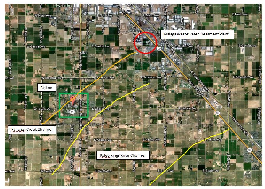
1 EASTON, CA POLLUTANT PLUMES By Dr. David Cehrs April 2012 Sampling for pollutants at Easton, CA occurred in and again in At both times nitrates and DBCP were sampled. In 2012 uranium and TCP were also sampled. Potential sources for nitrates in Easton include septic tanks at the Easton dwellings, synthetic agricultural fertilizer, and the Malaga sewage treatment plant percolation pond some three miles up the hydraulic gradient from Easton. DBCP was used as an agricultural soil fumigant for nematodes in vineyards. TCP was briefly used as an additive in Telone, an agricultural soil fumigant, but more importantly it was used as an industrial solvent for paint and grease. Potential TCP sources are along the Highway 99 corridor in and near Malaga. Uranium is a naturally occurring element with origins in the granitic rocks of the Sierra Nevada. The derived sediments of the Sierra, now deposited in the San Joaquin Valley, have residual uranium within them and are preferentially found with clays and organic material. I have plotted nitrate concentrations versus uranium, DBCP, and TCP. There is a very interesting correlation between nitrates and uranium but there seems to be no real correlation between nitrates and DBCP or TCP. Why there is a correlation between nitrate and uranium is a very interesting question that needs to be answered. The lack of correlation between nitrates and DBCP would seem to indicate that if the nitrate source is agricultural the source material was applied in different areas and at different rates or have moved differentially in the subsurface. Alternatively, if the nitrate source is not agricultural this would disassociate the two constituent concentrations from one another. Assuming that the majority of the TCP is from industrial use, the lack of correlation between nitrates and TCP indicate different sources. I then plotted and contoured the sampled constituents. In all plots the areas in color are above the constituent MCL (NO3, U, DBCP) or concentration goal (TCP). Between 1997 and 2012 nitrate concentrations have increased in absolute values and the area affected has increased. Of more interest is the areal distribution of the nitrates in 2012 with NE-SW aligned areas of higher and lower nitrate values. These areas are very possibly influenced by the sedimentary geology of the area which has subsurface, sandier paleo-channels of both the Kings River and Fancher Creek (see the aerial photo). Subsurface vadose zone and groundwater flow would be controlled by these paleo-channel sands and direct groundwater flow preferentially along and through them. The uranium plot show a striking similarity to the nitrate plot with a very prominent NE- SW alignment of the higher and lower concentrations. This then posits the question why are the uranium and nitrate concentrations correlated so well spatially? Has the subsurface sedimentary geology, sandier paleo-channel or flood plain clay deposits, preferentially distributed the
2 uranium, or possibly has the nitrate in the groundwater flowing through these different deposit types influenced or remobilized the sedimentary uranium? The DBCP concentrations have declined between 1997 and But the plume has not really moved, which is interesting. Other DBCP plumes in the greater Fresno area have not only moved with time but dissipated over time. The Easton plume seems to be stationary but dissipating. The high TCP concentrations are to the south and east but overlap the high-low boundary of the nitrates and uranium. In this southeast direction are the sandier, paleo-channel deposits of the Kings River. Could the TCP be coming from the Highway 99 corridor and flowing down gradient in the sandier deposits? It is my guess that there is substantial sedimentary geologic control over groundwater flow paths and that these preferred flow paths are influencing the pollutants beneath Easton. Things that need to be determined: 1. Source of the nitrates sewage (Easton and/or Malaga), agricultural, or soil. 2. Figure out the relationship between nitrates and uranium. Are the nitrates influencing the mobilization of the uranium from the sediments. 3. Why has the DBCP plume not moved beneath Easton? 4. What is the source for TCP industry along the highway 99 corridor? 5. What is the relationship between subsurface geology and the concentrations of the pollutants? Is the geology controlling groundwater flow and the pollutants there in?
3 U ug/l EASTON, CA N O 3 v s U ran iu m NO3 mg/l
4 DBCP ug/l EASTON, CA NO3 v s DBCP N O 3 m g / l
5 TCP EASTON, CA NO3 v s TCP NO3
6

7

8
9
10
11
12
Water, geology, climate & soils: Sierra Nevada, Merced River & Central Valley connections
 Water, geology, climate & soils: Sierra Nevada, Merced River & Central Valley connections Geography & geology Merced River basin Climate & hydrology Soils & soil formation Roger Bales UC Merced Water,
Influence of Paleochannels on Seepage
 Study 4 Influence of Paleochannels on Seepage Public Draft 2014 Monitoring and Analysis Plan September 2013 August 2012 Influence of Paleochannels on Seepage 1. Statement of Need Historical maps, aerial
Essentials of Geology, 11e
 Essentials of Geology, 11e Groundwater Chapter 10 Instructor Jennifer Barson Spokane Falls Community College Geology 101 Stanley Hatfield Southwestern Illinois Co Jennifer Cole Northeastern University
Module/Unit: Landforms Grade Level: Fifth
 Module/Unit: Landforms Grade Level: Fifth PA Academic Standards for Science and Technology and Environment and Ecology: 3.1.7.B Describe the use of models as an application or scientific or technological
Hydrogeology of Karst NE Wisconsin. Dr. Maureen A. Muldoon UW-Oshkosh Geology Department
 Hydrogeology of Karst NE Wisconsin Dr. Maureen A. Muldoon UW-Oshkosh Geology Department WI Bedrock Outline Karst Landscapes Existing WQ Data Flow in Karst Aquifers Overview of Silurian Aquifer Water Level
Directed Reading. Section: Types of Maps
 Skills Worksheet Directed Reading Section: Types of Maps 1. What are some of the characteristics of an area shown on maps used by Earth scientists? a. types of animals, types of plants, types of minerals
Prof. Stephen A. Nelson EENS 111. Groundwater
 Page 1 of 8 Prof. Stephen A. Nelson EENS 111 Tulane University Physical Geology This page last updated on 20-Oct-2003 is water that exists in the pore spaces and fractures in rock and sediment beneath
Big Rivers Electric Corporation Disposal of Coal Combustion Residuals (CCR) from Electric Utilities Final Rule CCR Impoundment Liner Assessment Report
 from Electric Utilities Final Rule CCR Impoundment Liner Assessment Report") Big Rivers Electric Corporation Disposal of Coal Combustion Residuals (CCR) from Electric Utilities Final Rule CCR Impoundment Liner Assessment Report CCR Surface Impoundment Information Name: Operator:
Big Rivers Electric Corporation Disposal of Coal Combustion Residuals (CCR) from Electric Utilities Final Rule CCR Impoundment Liner Assessment Report CCR Surface Impoundment Information Name: Operator:
Setting MOUNTAIN HOUSE NEIGHBORHOODS I AND J INITIAL STUDY 5. ENVIRONMENTAL CHECKLIST 6. GEOLOGY AND SOILS. Issue
 Issue Less Than Significant or No Impact Potential Significant Impact Adequately Addressed in MEIR MEIR Required Additional Review: No Significant Impact Less Than Significant Impact Due to Mitigation
Information Pamphlet 8 WATER LEVELS IN THE UPPER WEST BENCH ALLUVIAL AQUIFER, RED LODGE, MONTANA
 Ground Water Assessment Program Information Pamphlet 8 WATER LEVELS IN THE UPPER WEST BENCH ALLUVIAL AQUIFER, RED LODGE, MONTANA Camela Carstarphen, Thomas Patton, and John I. LaFave View of Remington
11/22/2010. Groundwater in Unconsolidated Deposits. Alluvial (fluvial) deposits. - consist of gravel, sand, silt and clay
 deposits. - consist of gravel, sand, silt and clay") Groundwater in Unconsolidated Deposits Alluvial (fluvial) deposits - consist of gravel, sand, silt and clay - laid down by physical processes in rivers and flood plains - major sources for water supplies
Groundwater in Unconsolidated Deposits Alluvial (fluvial) deposits - consist of gravel, sand, silt and clay - laid down by physical processes in rivers and flood plains - major sources for water supplies
1. Base your answer to the following question on the map below, which shows the generalized bedrock of a part of western New York State.
 1. Base your answer to the following question on the map below, which shows the generalized bedrock of a part of western New York State. 3. The table below describes the deposits that an observer saw while
GROUNDWATER MONITORING DATA 2016 SAMPLING EVENT HARSHAW CHEMICAL COMPANY FUSRAP SITE
 GROUNDWATER MONITORING DATA 2016 SAMPLING EVENT HARSHAW CHEMICAL COMPANY FUSRAP SITE U.S. Army Corps of Engineers Buffalo District Building Strong April 2017 ly Utilized Sites Remedial Action Program The
2.5.3 Willow Creek Valley
 2.5.3 Willow Creek Valley Identified as a priority groundwater basin based on stakeholder input, land use, water source patterns, and existing groundwater well infrastructure, Willow Creek Valley is in
Biogeochemical cycles
 Lecture -2: Biogeochemical cycles ENV 107: Introduction to Environmental Science Dr. A.K.M. Saiful Islam Case Study: Lake Washington The city of Seattle, USA lies between two major bodies of water- saltwater
IMPORTANCE OF GEOLOGIC CHARACTERIZATION FOR LEVEE FOUNDATION AND BORROW MATERIALS AS STUDIED AT THE INDIAN GRAVES LEVEE DISTRICT, ADAMS COUNTY, IL
 IMPORTANCE OF GEOLOGIC CHARACTERIZATION FOR LEVEE FOUNDATION AND BORROW MATERIALS AS STUDIED AT THE INDIAN GRAVES LEVEE DISTRICT, ADAMS COUNTY, IL Conor Watkins Missouri University of Science and Technology
Chapter 14. Groundwater
 Chapter 14 Groundwater Importance of groundwater! Groundwater is water found in the pores of soil and sediment, plus narrow fractures in bedrock! Groundwater is the largest reservoir of fresh water that
Landscape evolution. An Anthropic landscape is the landscape modified by humans for their activities and life
 Landforms Landscape evolution A Natural landscape is the original landscape that exists before it is acted upon by human culture. An Anthropic landscape is the landscape modified by humans for their activities
Wisconsin s Hydrogeology: an overview
 2012 Soil and Water Conservation Society Conference Stevens Point, WI Feb 9, 2012 Wisconsin s Hydrogeology: an overview Ken Bradbury Wisconsin Geological and Natural History Survey University of Wisconsin-Extension
Surface Processes Focus on Mass Wasting (Chapter 10)
") Surface Processes Focus on Mass Wasting (Chapter 10) 1. What is the distinction between weathering, mass wasting, and erosion? 2. What is the controlling force in mass wasting? What force provides resistance?
Surface Processes Focus on Mass Wasting (Chapter 10) 1. What is the distinction between weathering, mass wasting, and erosion? 2. What is the controlling force in mass wasting? What force provides resistance?
Sacramento Valley Groundwater Basin, Sutter Subbasin
 Sacramento Valley Groundwater Basin, Sutter Subbasin Groundwater Basin Number: 5-21.62 County: Sutter Surface Area: 234,400 acres (366 square miles) Boundaries and Hydrology The Sutter Subbasin lies in
Relative Age-dating -- Discovery of Important Stratigraphic Principles
 Roger Steinberg Assistant Professor of Geology Del Mar College 101 Baldwin Corpus Christi, TX 78404 361-698-1665 rsteinb@delmaredu Abstract: When piecing together the geologic history of the Earth, geologists
GOVERNMENT OF NEPAL MINISTRY OF IRRIGATION GROUND WATER RESOURCES DEVELOPMENT BOARD BABARMAHAL, KATHMANDU, NEPAL
 GOVERNMENT OF NEPAL MINISTRY OF IRRIGATION GROUND WATER RESOURCES DEVELOPMENT BOARD BABARMAHAL, KATHMANDU, NEPAL GIS Based Updating of Groundwater Level Siraha District Final Report Submitted to Ground
Cattaraugus Creek: A Story of Flowing Water and the Geology of the Channel It Flows Through Presentation to West Valley Citizen Task Force 4/27/16
 Cattaraugus Creek: A Story of Flowing Water and the Geology of the Channel It Flows Through Presentation to West Valley Citizen Task Force 4/27/16 Raymond C. Vaughan, Ph.D. What happens if you drop a
=%REPORT RECONNAISSANCE OF CHISHOLM LAKE PROSPECT. October 25, 1977
 =%REPORT ON FIELD RECONNAISSANCE OF CHISHOLM LAKE PROSPECT October 25, 1977 Bruce D. Vincent Imperial Oil Limited, Minerals - Coal, CALGARY, ALBERTA CHISHOLM LAKE PROSPECT Introduction The Chisholm Lake
Enhanced Characterization of the Mississippi River Valley Alluvial Aquifer Using Surface Geophysical Methods
 Photo by Shane Stocks, U.S. Geological Survey Enhanced Characterization of the Mississippi River Valley Alluvial Aquifer Using Surface Geophysical Methods Presented by Ryan F. Adams US Geological Survey
Geology (Mellow) Hike, Santa Lucia Memorial Park February 16, I. Overview of Santa Lucia Range geology and tectonic history
 Hike, Santa Lucia Memorial Park February 16, I. Overview of Santa Lucia Range geology and tectonic history") Geology (Mellow) Hike, Santa Lucia Memorial Park February 16, 2015 I. Overview of Santa Lucia Range geology and tectonic history A. Basement Rocks 1. Salinian Block Rocks Sierra Nevada Type, continental
Geology (Mellow) Hike, Santa Lucia Memorial Park February 16, 2015 I. Overview of Santa Lucia Range geology and tectonic history A. Basement Rocks 1. Salinian Block Rocks Sierra Nevada Type, continental
Weathering and Soil Formation. Chapter 10
 Weathering and Soil Formation Chapter 10 Old and New Mountains The Appalachian Mountains appear very different from the Sierra Mountains. The Appalachians are smaller, rounded, gently sloping, and covered
Napa County Comprehensive Groundwater Monitoring Program 2015 Annual Report and CASGEM Update
 Napa County Comprehensive Groundwater Monitoring Program 2015 Annual Report and CASGEM Update April 21, 2016 Watershed Information & Conservation Council By Vicki Kretsinger Grabert Overview Evolving groundwater
Chapter 5. The Biogeochemical Cycles. Botkin & Keller Environmental Science 5e
 Chapter 5 The Biogeochemical Cycles How Chemicals Cycle Biogeochemical Cycle The complete path a chemical takes through the four major components or reservoirs of Earth s systems 1. Atmosphere 2. Hydrosphere
Name: Mid-Year Review #2 SAR
 Name: Mid-Year Review #2 SAR Base your answers to questions 1 through 3 on on the diagram below, which shows laboratory materials used for an investigation of the effects of sediment size on permeability,
depression above scarp scarp
 1 LAB 1: FIELD TRIP TO McKINLEYVILLE AND MOUTH OF THE MAD RIVER OBJECTIVES: a. to look at geomorphic and geologic evidence for large scale thrust-faulting of young sediments in the Humboldt Bay region
Chapter 3 Erosion in the Las Vegas Wash
 Chapter 3 Erosion in the Las Vegas Wash Introduction As described in Chapter 1, the Las Vegas Wash (Wash) has experienced considerable change as a result of development of the Las Vegas Valley (Valley).
Structural Geology Lab. The Objectives are to gain experience
 Geology 2 Structural Geology Lab The Objectives are to gain experience 1. Drawing cross sections from information given on geologic maps. 2. Recognizing folds and naming their parts on stereoscopic air
River/Stream Erosion Notes
 Name Date ES per Mr. Williams River/Stream Erosion Notes Erosion: the of weathered material. FACT: Running water moves more sediment than ANY other type of erosion. 1. The Water Cycle What happens when
Ms. A. Mormando's Class *
 8 th Grade Science Essential Standard: 8.E.1.1 Explain the structure of the hydrosphere including: Water distribution on Earth; Local river basin and water availability Stream - A stream is a body of water
Land subsidence due to groundwater withdrawal in Hanoi, Vietnam
 Land Subsidence (Proceedings of the Fifth International Symposium on Land Subsidence, The Hague, October 1995). 1AHS Publ. no. 234, 1995. 55 Land subsidence due to groundwater withdrawal in Hanoi, Vietnam
GY 111 Lecture Note Series Sedimentary Environments 2: Rivers and Deltas
 GY 111 Lecture Notes D. Haywick (2008-09) 1 GY 111 Lecture Note Series Sedimentary Environments 2: Rivers and Deltas Lecture Goals A) Rivers and Deltas (types) B) Water Flow and sedimentation in river/deltas
Appendix D. Sediment Texture and Other Soil Data
 5 6 7 8 Appendix D. Sediment Texture and Other Soil Data This appendix describes the sediment texture of the aquifer system in the Restoration Area. The contents of this appendix describe the: Importance
In this lab, we will study and analyze geologic maps from a few regions, including the Grand Canyon, western Wyoming, and coastal California.
 Name: Lab Section: work in groups, but each person turns in his/her own GEOSCIENCE 001 LAB UNDERSTANDING GEOLOGIC MAPS Geologic maps are colorful and even beautiful, but they also contain an amazing amount
Lab Topographic Maps. Name: Partner: Purpose. Background Information
 Lab Topographic Maps Name: Partner: Purpose The purpose of this lab is to familiarize you with graphic representations of the Earth s surface primarily maps. Simple line maps show the spatial relationship
Structural Geology Lab. The Objectives are to gain experience
 Geology 2 Structural Geology Lab The Objectives are to gain experience 1. Drawing cross sections from information given on geologic maps. 2. Recognizing folds and naming their parts on stereoscopic air
Application of Nitrogen and Oxygen Isotopes to Identify Sources of Nitrate
 Application of Nitrogen and Oxygen Isotopes to Identify Sources of Nitrate Illinois Groundwater Consortium Conference April 9, 2001 George S. Roadcap, Illinois State Water Survey Keith C. Hackley, Illinois
Ch 10 Deposition Practice Questions
 1. Base your answer to the following question on the data table below. Six identical cylinders, A through F, were filled with equal volumes of sorted spherical particles. The data table shows the particle
12. Lead, Pb (atomic no. 82)
") 12. Lead, Pb (atomic no. 82) - Sources of Pb contamination include mining, metal processing, lead battery manufacturing, chemical and paint manufacturing, and lead wastes. -USEPA drinking water action
12. Lead, Pb (atomic no. 82) - Sources of Pb contamination include mining, metal processing, lead battery manufacturing, chemical and paint manufacturing, and lead wastes. -USEPA drinking water action
Do you think sediment transport is a concern?
 STREAM RESTORATION FRAMEWORK AND SEDIMENT TRANSPORT BASICS Pete Klingeman 1 What is Your Restoration Project Like? k? Do you think sediment transport is a concern? East Fork Lewis River, WA Tidal creek,
Result of Field Geological Survey and Ground Truth for the Analysis Date: 2007/7/5 Location (UTM) Elev Geological Unit Point No. NT-02 VSW Index 260,7
 Elev Geological Unit Point No. NT-02 VSW Index 260,7") Date: Point No. 2007/7/5 NT-01 Result of Field Geological Survey and Ground Truth for the Analysis Location (UTM) Topography of granite hill in flat land Lithology: Medium grained hornblende granite. Topography:
Date: Point No. 2007/7/5 NT-01 Result of Field Geological Survey and Ground Truth for the Analysis Location (UTM) Topography of granite hill in flat land Lithology: Medium grained hornblende granite. Topography:
5.11 MINERAL RESOURCES
 5.11 This section of the Draft PEIR evaluates the potential impacts to mineral resources in the Plan Area from implementation of the Clovis General Plan and Development Code Update (proposed project).
STUDY GUIDE FOR CONTENT MASTERY. Surface Water Movement
 Surface Water SECTION 9.1 Surface Water Movement In your textbook, read about surface water and the way in which it moves sediment. Complete each statement. 1. An excessive amount of water flowing downslope
Lecture 15: Subsidence
 Lecture 15: Subsidence Key Questions 1. How does removal of groundwater cause subsidence on a regional scale? 2. Under what conditions does a building sink into sediment? 3. Why do clays consolidate more
Earth s Surface. Name Date. Key Concepts Choose the letter of the best answer.
 Earth s Surface Key Concepts Choose the letter of the best answer. Unit Test A 1. A river starts as a steep channel in the mountains. It then leaves the mountains and enters a flatter area of land. It
EARTH S CHANGING SURFACE
 EARTH S CHANGING SURFACE Weathering Together, weathering and erosion work continuously to wear down the material on Earth s surface. weathering process that breaks down rock and other substances of Earth
Uranium Mining Activities in Los Gigantes, Argentina: Possible Case Study Site
 Uranium Mining Activities in Los Gigantes, Argentina: Possible Case Study Site Dr. Daniel S. Cicerone Soil and Water Chemistry Division Department of Environment, Chemistry Management National Atomic Energy
Relative aging, fossils, natural disasters
 Relative aging, fossils, natural disasters Rocks breaking down into smaller pieces Water that moves over Earth s surface Causes sheet erosion Moves downhill Forms rills and gullies Erosion creates valleys,
3.1 Regional Physical Setting
 Chapter 3 Hydrogeomorphic Setting This chapter describes the physical setting of the inventory area and the four physiographic regions used to categorize the geomorphology of the inventory area. The overview
Gradualism versus Catastrophism Curriculum written by XXXXX
 Gradualism versus Catastrophism Curriculum written by XXXXX A curriculum written with the goal of educating 8 th grade science students on the difference between gradual and cataclysmic geological events
For personal use only
 Limited ASX code: RNU The Eastern Eyre Copper Project Presented at the South Australian Resources and Energy Investment Conference Adelaide, 14 April 2015 David Christensen, Managing Director 1 Eastern
LESSONS LEARNED FROM MINING-INFLUENCED WATERS STUDIES AT THE NEW MEXICO BUREAU OF GEOLOGY AND MINERAL RESOURCES
 LESSONS LEARNED FROM MINING-INFLUENCED WATERS STUDIES AT THE NEW MEXICO BUREAU OF GEOLOGY AND MINERAL RESOURCES Virginia T. McLemore New Mexico Bureau of Geology and Mineral Resources New Mexico Institute
Application of Transition Probability Geostatistics in a Detailed Stratigraphic Framework. Gary Weissmann University of New Mexico
 Application of Transition Probability Geostatistics in a Detailed Stratigraphic Framework Gary Weissmann University of New Mexico ACKNOWLEDGEMENTS National Science Foundation American Chemical Society
Michigan s Geology and Groundwater
 Michigan s Geology and Groundwater Ralph J. Haefner Deputy Director U.S. Geological Survey Michigan-Ohio Water Science Center Lansing, Michigan Outline About the USGS Geology 101 Michigan s geology Bedrock
Daniel Koning, Peggy Johnson, and John Hawley. New Mexico Bureau of Geology and Mineral Resources
 Daniel Koning, Peggy Johnson, and John Hawley Daniel Koning 1, Gary Smith 2, and Adam Read 1 1 New Mexico Bureau of Geology and Mineral Resources 2 University of New Mexico Santa Fe Group Definition (Spiegel
DATA ACQUISITION METHODS FOR GROUNDWATER INVESTIGATION AND THE SITING OF WATER SUPPLY WELLS
 DATA ACQUISITION METHODS FOR GROUNDWATER INVESTIGATION AND THE SITING OF WATER SUPPLY WELLS M.B.J. Foster Tetra Tech EM Inc., San Francisco, CA, USA Keywords: Groundwater, water wells, drilled wells, geophysical
4.9 GEOLOGY AND SOILS
 4.9 GEOLOGY AND SOILS 4.9.1 EXISTING CONDITIONS TOPOGRAPHY AND RELIEF Zone 40 is located in the central portion of Sacramento County. The topography of the county is represented by three physiographic
GEOL.3250 Geology for Engineers Glacial Geology
 GEOL.3250 Geology for Engineers Glacial Geology NAME Part I: Continental Glaciation Continental glaciers are large ice sheets that cover substantial portions of the land area. In the region of accumulation
The Geology of Sebago Lake State Park
 Maine Geologic Facts and Localities September, 2002 43 55 17.46 N, 70 34 13.07 W Text by Robert Johnston, Department of Agriculture, Conservation & Forestry 1 Map by Robert Johnston Introduction Sebago
Soils, Hydrogeology, and Aquifer Properties. Philip B. Bedient 2006 Rice University
 Soils, Hydrogeology, and Aquifer Properties Philip B. Bedient 2006 Rice University Charbeneau, 2000. Basin Hydrologic Cycle Global Water Supply Distribution 3% of earth s water is fresh - 97% oceans 1%
Scholars Research Library. Predicting the aquifer characteristic within the major towns in Ndokwa land
 Available online at www.scholarsresearchlibrary.com Archives of Physics Research, 2011, 2 (4):1-5 (http://scholarsresearchlibrary.com/archive.html) ISSN : 0976-0970 CODEN (USA): APRRC7 Predicting the aquifer
,Baynes Lake. TO...?&.?...A 2...KO.?'!!&... Sr. *logical Engineer
 > i evernment OF BRITISH COLUMBIA a TO...?&.?...A 2....KO.?'!!&... Sr. *logical Engineer... Grou,,water. Section Hydrology Division Wat.er... In~.~s.tiga.ti.On.s..Branck.... 5 u BJECT...C;.roun.dw.ater...Snve
Impact of the Danube River on the groundwater dynamics in the Kozloduy Lowland
 GEOLOGICA BALCANICA, 46 (2), Sofia, Nov. 2017, pp. 33 39. Impact of the Danube River on the groundwater dynamics in the Kozloduy Lowland Peter Gerginov Geological Institute, Bulgarian Academy of Sciences,
4.10 GEOLOGY, SOILS, AND SEISMICITY
 4.10 GEOLOGY, SOILS, AND SEISMICITY 4.10.1 INTRODUCTION This section describes the geology of the SVRTC and the susceptibility of site soils to seismically induced hazards. Faults in the corridor and past
A Risk-based Groundwater Modelling Study for Predicting Thermal Plume Migration from SAGD Well-pads
 A Risk-based Groundwater Modelling Study for Predicting Thermal Plume Migration from SAGD Well-pads Rudy Maji, Ph.D., Golder Associates Solaleh Khezri, M.Sc., AB Scientific Intern (Golder Associates) Don
KRIS wsbssm. IBHiiilll
 KRIS wsbssm IBHiiilll Digitized by the Internet Archive in 2012 with funding from University of Illinois Urbana-Champaign http://archive.org/details/engineeringaspec34ekbl STATE OF ILLINOIS HENRY HORNER,
CAUSES FOR CHANGE IN STREAM-CHANNEL MORPHOLOGY
 CAUSES FOR CHANGE IN STREAM-CHANNEL MORPHOLOGY Chad A. Whaley, Department of Earth Sciences, University of South Alabama, MobileAL, 36688. E-MAIL: caw408@jaguar1.usouthal.edu The ultimate goal of this
' International Institute for Land Reclamation and Improvement. 2 Groundwater Investigations. N.A. de Ridder'? 2.1 Introduction. 2.
 2 Groundwater Investigations N.A. de Ridder'? 2.1 Introduction Successful drainage depends largely on a proper diagnosis of the causes of the excess water. For this diagnosis, one must consider: climate,
Section 11.1 pp Where Mountains Form
 Section 11.1 pp. 236 237 Where Mountains Form Chapter 11 Set a Purpose: TE, p. 236 Reading Study Guide, p. 36 Discussion: TE, p. 236 Differentiating ion Reading Support: TE, p. 236 Visual Teaching Interpret
Eco Bay Pathways Watershed related exhibits in the Exploratorium
 Eco Bay Pathways Watershed related exhibits in the Exploratorium This Pathwa y is a guide to engagement wi th museu m exhibit s at the Explo ratorium and includes activiti es for p re- an d post-fi eldtri
Year 6. Geography. Revision
 Year 6 Geography Revision November 2017 Rivers and World knowledge How the water cycle works and the meaning of the terms evaporation, condensation, precipitation, transpiration, surface run-off, groundwater
Chapter 8 Fetter, Applied Hydrology 4 th Edition, Geology of Groundwater Occurrence
 Chapter 8 Fetter, Applied Hydrology 4 th Edition, 2001 Geology of Groundwater Occurrence Figure 8.42. Alluvial Valleys ground-water region. Fetter, Applied Hydrology 4 th Edition, 2001 Fetter, Applied
Basin & Range / Mojave Desert
 Basin & Range / Mojave Desert Basin & Range vs. Great Basin 1 2/20/2016 An overview of the last horst Basin and Range / Mojave Desert Summary: Granitic, volcanic, marine sedimentary, non marine sedimentary,
PRELIMINARY. Select Geophysical Methods and Groundwater Modeling: Examples from USGS studies. Claudia Faunt and a cast of others
 Select Geophysical Methods and Groundwater Modeling: Examples from USGS studies Claudia Faunt and a cast of others Current Preliminary Studies Stanford Water in the West Groundwater Data Workshop Series:
Pee Dee Explorer. Science Standards
 Science Standards About Pee Dee Explorer What does it mean when someone says they are from the "Pee Dee" of South Carolina? A place is bigger than its physical geography. A "sense of place" weaves together
Class Notes: Surface Processes
 Name: Date: Period: Surface Processes The Physical Setting: Earth Science Class Notes: Surface Processes I. Weathering and Soils Weathering -! Sediments -! Weathering occurs when rocks are exposed to:
APPLICATION OF ELECTRICAL RESISTIVITY TOMOGRAPHY FOR SAND UNDERWATER EXTRACTION
 International Scientific Conference GEOBALCANICA 2018 APPLICATION OF ELECTRICAL RESISTIVITY TOMOGRAPHY FOR SAND UNDERWATER EXTRACTION Maya Grigorova Ivaylo Koprev University of Mining and Geology St. Ivan
LAB 5: LANDSLIDE RECOGNITION AND MAPPING
 Geology 350 1 LAB 5: LANDSLIDE RECOGNITION AND MAPPING OBJECTIVES: a. to learn to recognize and classify landslides on airphotos and topographic maps b. to learn to recognize landslide topography on topographic
EPS 50 - Lab 10: Groundwater Flow and Glaciers
 Name: EPS 50 - Lab 10: Groundwater Flow and Glaciers Part 1: Groundwater Flow Part 2: Darcy s Law Part 3: Glacial Deposits and Flow -Chapter 17, p. 478-492: Hydrology of Groundwater -Chapter 17, p. 485-486:
BASIC PRINCIPLES OF GROUND-WATER OCCURANCE AND FLOW
 BASIC PRINCIPLES OF GROUND-WATER OCCURANCE AND FLOW GWPC Annual Forum Sept. 27-30, 2015 Oklahoma City, OK Mike Wireman Water well Rural Romania Water well Castle in Austria 1 ??? 2 BASIC PRINCIPLES OF
LAUREL MARCUS California Land Stewardship Institute OVERVIEW OF GROUNDWATER STUDIES IN THE RUSSIAN RIVER WATERSHED
 LAUREL MARCUS California Land Stewardship Institute OVERVIEW OF GROUNDWATER STUDIES IN THE RUSSIAN RIVER WATERSHED - 60% OF LAND AREA } 20% OF LAND AREA } 20% OF LAND AREA GEOLOGY OF THE RUSSIAN RIVER
Activity Submitted by Tim Schroeder, Bennington College,
 Structural Analysis of a Hot Dry Rock Geothermal Energy System Activity Submitted by Tim Schroeder, Bennington College, tschroeder@bennington.edu Description: This project applies basic geologic skills
Bulletin of Earth Sciences of Thailand
 Quantitative Seismic Geomorphology of Early Miocene to Pleistocene Fluvial System of Northern Songkhla Basin, Gulf of Thailand Oanh Thi Tran Petroleum Geoscience Program, Department of Geology, Faculty
TEACHER BACKGROUND KNOWLEDGE. Surface Processes: Weathering and Erosion
 TEACHER BACKGROUND KNOWLEDGE Surface Processes: Weathering and Erosion Core Concepts Precipitation (caused by the water cycle) and wind cause rocks to be broken into smaller pieces in the process called
Unit 7.2 W.E.D. & Topography Test
 Name: Score: Unit 7.2 W.E.D. & Topography Test 1. 2. 3. 4. 5. 6. 7. 8. 9. 10. 11. 12. 13. 14. 15. 16. 17. 18. 19. 20. 21. 22. 23. 24. 25. 1. The formation of mountains is due mainly to while the destruction
Modeling the Interconnection between Surface and Groundwater
 Modeling the Interconnection between Surface and Groundwater Andrew Warnock- GetWet, Colorado State University GetWet.Colostate.edu Three Explorations 1. Model two fundamentally different types of streams.
Groundwater. Earth Chapter 17
 Groundwater Earth Chapter 17 Chapter 17 Groundwater Importance of Groundwater Groundwater is water found in the pores of soil and sediment, plus narrow fractures in bedrock Groundwater and the Hydrosphere
IPMO2-1. Groundwater Modelling of Chiang Rai Basin, Northern Thailand. Sattaya Intanum* Dr.Schradh Saenton**
 IPMO2-1 Groundwater Modelling of Chiang Rai Basin, Northern Thailand Sattaya Intanum* Dr.Schradh Saenton** ABSTRACT Chiang Rai basin, situated in Chiang Rai and Phayao provinces covering an area of 11,000
GEOLOGY, SOILS, AND SEISMICITY
 4.9 GEOLOGY, SOILS, AND SEISMICITY 4.9.1 Introduction Information about the geological conditions and seismic hazards in the study area was summarized in the FEIR, and was based on the Geotechnical Exploration
A GEOLOGIC TRIP to the SAN ANDREAS FAULT
 A GEOLOGIC TRIP to the SAN ANDREAS FAULT San Andreas Hot Spot Loop Road Hot Spot P Parking San Andreas Fault Interpretive Trail Fault Zone Map: San Andreas Fault Zone During the 25 million years that the
Geomorphic Importance of Winter Peak Flows and Annual Snowmelt Hydrographs in a Sierra Nevada Boulder-Bedrock River
 Geomorphic Importance of Winter Peak Flows and Annual Snowmelt Hydrographs in a Sierra Nevada Boulder-Bedrock River Scott McBain and Bill Trush McBain & Trush, Inc. Clavey River and Cherry Creek vicinity
Differentiation of chloride source using stable chlorine isotopes
 Differentiation of chloride source using stable chlorine isotopes RemTech 2009 Banff, Alberta October 14-16 2009 Dr. Alec Blyth and Tom Anthony 1 1 currently City of Calgary Background: DOW Chemical Canada
27. Running Water I (p ; )
") 27. Running Water I (p. 424-436; 440-444) Hydrosphere How much of the Earth s surface is covered by water? Earth's water is collectively called the and is stored in a number of so-called as follows: 1.
27. Running Water I (p. 424-436; 440-444) Hydrosphere How much of the Earth s surface is covered by water? Earth's water is collectively called the and is stored in a number of so-called as follows: 1.
Why is Sebago Lake so deep?
 Maine Geologic Facts and Localities February, 1999 Why is Sebago Lake so deep? 43 51 13.36 N, 70 33 43.98 W Text by Robert A. Johnston, Department of Agriculture, Conservation & Forestry 1 Introduction