BASIC PRINCIPLES OF GROUND-WATER OCCURANCE AND FLOW
|
|
|
- Hope Lynch
- 5 years ago
- Views:
Transcription


1 BASIC PRINCIPLES OF GROUND-WATER OCCURANCE AND FLOW GWPC Annual Forum Sept , 2015 Oklahoma City, OK Mike Wireman Water well Rural Romania Water well Castle in Austria 1
2 ??? 2
3 BASIC PRINCIPLES OF GW OCCURRENCE AND FLOW OUTLINE FOR THIS TALK WHAT IS GW? HYDROLOGIC CYCLE GEOLOGY AND GROUND WATER GW HYDROLOGY GROUND-WATER / SURFACE-WATER INTERACTION GROUND-WATER QUALITY 3
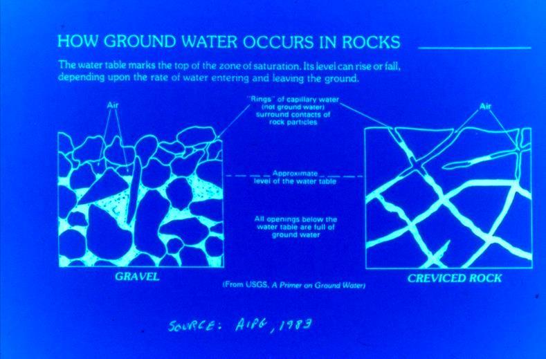
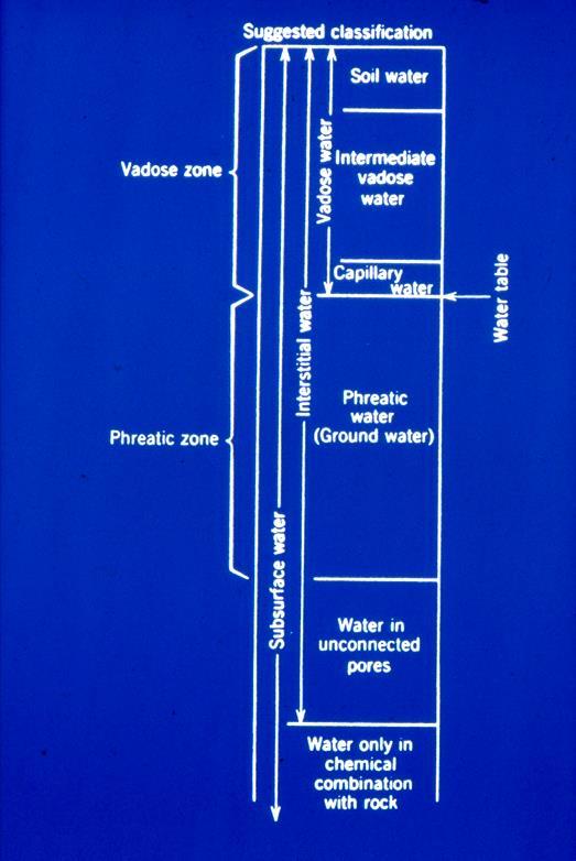
4 GROUND WATER Subsurface water that occurs beneath the water table in geological sediments and formations that are fully saturated. Subsurface water also occurs with-in near surface unsaturated sediments and formations above the water table. In the unsaturated zone voids are filled with air and water. 4
5 5
6 6
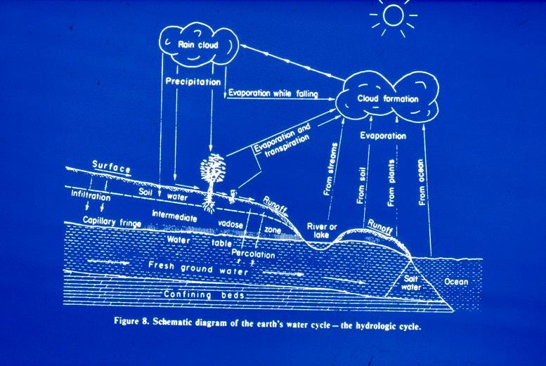
7 Estimated Water Balance of the World Hydrologic reservoir Volume (%) Residence time Oceans / seas 94 ~ 4000 years Ground water 4 2 weeks - 30,000 years Glaciers /icecaps years Lakes <0.01 ~ 10 years Wetlands < years Rivers <0.01 ~ 2 weeks Soil Moisture < weeks -1 year Nice, 1971 (assumes equal distribution over entire surface of earth) 7
8 BASIC PRINCIPLES OF GW OCCURRENCE AND FLOW OUTLINE FOR THIS TALK WHAT IS GW? GEOLOGY AND GROUND WATER Geology of aquifers GW regions, hydrogeologic settings, hydrostratigraphic units GW HYDROLOGY GROUND-WATER / SURFACE-WATER INTERACTION GROUND-WATER QUALITY 8
9 IMPORTANCE OF GEOLOGY GW OCCURS IN GEOLOGIC DEPOSITS AND FORMATIONS SUBSURFACE IS VERY HETEROGENEOUS LITHOLOGY / MINERALOGY OF GEOLOGIC MATERIALS GREATLY AFFECTS HYDRAULIC PROPERTIES AND GW QUALITY GEOLOGY CONTROLS TYPES OF AQUIFERS THAT OCCUR IN AN AREA AQUIFERS /HYDROSTRATIGRAPHIC UNITS Deposits and formations are grouped or split based on hydraulic characteristicsnot lithology, fossils, age 9

10 AQUIFER A geologic formation, part of a formation or group of formations that will yield significant quantities of water to a well 10
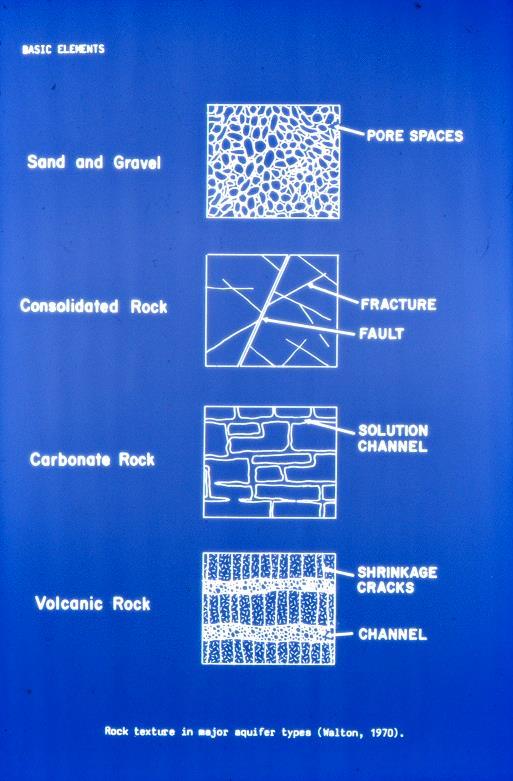
11 GEOLOGIC MEDIA UNCONSOLIDATED DEPOSITS vs CONSOLIDATED ROCKS Sedimentary Igneous unconsolidated -- clays, silts, sands, gravels, cobbles consolidated shale, sandstone, siltstone, conglomerate, limestone granites, basalts, diorites, monzonites, volcanic Metamorphic quartzite, slate, marble
12 12
13 Hydrologically important rock types Major Aquifers Gravel Sand Sandstone Limestone Basalt Aquicludes Clay Shale Minor Aquifers Till Conglomerate Siltstone Gneiss Quartzite Granite Marble 13
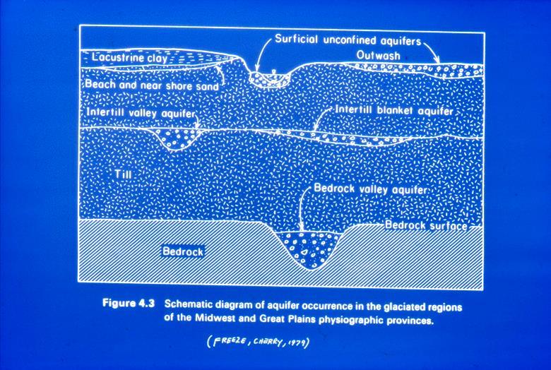
14 UNCONSOLIDATED DEPOSITS AND ROCKS AS AQUIFERS UNCONSOLIDATED FLUVIAL DEPOSITS INTERMONTANE VALLEY DEPOSITS COASTAL PLAIN DEPOSITS GLACIAL DEPOSITS SEDIMENTARY ROCKS IGNEOUS / METAMORPHIC ROCKS 14
15 Unconsolidated fluvial deposits Deposited by water Streams Lakes Glaciers Oceans Geometry /size of deposit depends on Depositional setting Source area and material Time 15

16 Features also occur in consolidated sedimentary rocks 16
17 17
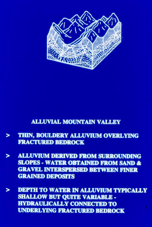
18 INTERMONTANE VALLEY DEPOSITS INTERMONTANE VALLEY: A basin like area between or within mountain ranges (also called a park) Formed by structural processes not by a river Contain thick sequences of unconsolidated and semi-consolidated alluvial/glacial/volcanic sediments 18

19 Often storage dominated 19
20 20
21 GLACIAL DEPOSITS GLACIAL FLUVIAL DEPOSITS: ALLUVIUM OUTWASH ICE CONTACT DEPOSITS: TILL GENERALLY HYDRAULICALLY CONNECTED TO SURFACE WATER. 21
22 22
23 CONSOLIDATED SEDIMENTARY ROCKS 70% OF ROCKS EXPOSED AT EARTHS SURFACE (OUTCROP / SUBCROP) SEDIMENTARY ROCK TYPES 25% CONGLOMERATE SANDSTONE 25% CARBONATES GYPSUM 50% SHALE SILTSTONE CLAYSTONE 23

24 Focus on Sedimentary Basins Basins contain oil /gas, coal, mineral and freshwater resources How to manage development of combined resources Minimize /mitigate environmental impacts
.")
25 0 Sedimentary basins in Western USA commonly have thick carbonate and sandstone formations at depth (1000s of ft.) which function as aquifers and aquifer systems. These aquifers extend over very large areas (1000s of mi 2 ). Significant meteoric (fresh) water at depth focused recharge Current research indicates significant permeability at depth -locally Oil & Gas deposits in shallow & deep formations gas occurs in deeper shale formations Hydrogeology of deep GW is poorly understood due to: Limited use High cost to characterize & develop 15-20,000 ft.
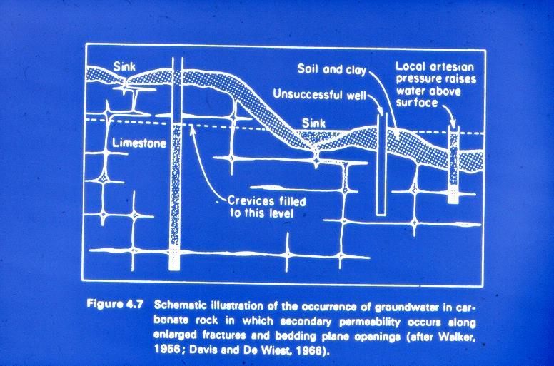
26 CARBONATE AQUIFERS PRIMARY: POROSITY HYDRAULIC COND. Clastic - High Mod Precipitate- Low Low SECONDARY POROSITY AND HYD. COND. Very important Solutional enlargement of fractures, joints and bedding planes Dissolution mechanisms favor development of larger openings Higher K in large openings Water in smaller openings at saturation Highly anisotropic and non-homogenous Water table in carbonate aquifers Be very flat due to high K Be discontinuous Be very deep in recharge areas 26
27 27
28 IGNEOUS / METAMORPHIC ROCKS AS AQUIFERS UNDERLIE 20% OF LAND SURFACE FRACTURE FLOW vs RADIAL FLOW VOLCANIC ROCKS- EXTENSIVE SECONDARY PERMEABILTY 28

29 Interflow 29
30 30
31 Hierarchical Framework for GW Systems GW Regions (15 Regions mapped by Heath, USGS) Geographic / physiographic areas where the compositions, arrangement and structure of the geologic formations that affect the occurance and flow of ground water are similar Hydrogeologic settings A composite description of all of the major geologic and hydrologic factors which control ground-water movement into, through and out of an area. It is a mappable unit with common hydrogeologic characteristics. Not mapped for much of USA A suite of hydrogeologic settings described for each gw region 31
32 Hierarchical Framework for GW Systems Aquifer A geologic formation, part of a formation or group of formations that will yield significant quantities of water to a well or spring Aquifer zones Subdivisions of aquifers with different hydrologic conditions Recharge area vs. discharge area Confined vs. unconfined Aquifer sites Specific features such as a spring, sinkhole, gaining reach of stream 32


33 Principle Aquifers United States 33
34 34

35 Western Mountain Ranges GW Region 35

36 Hydrogeologic setting Western Mountains Ranges GW Region 36
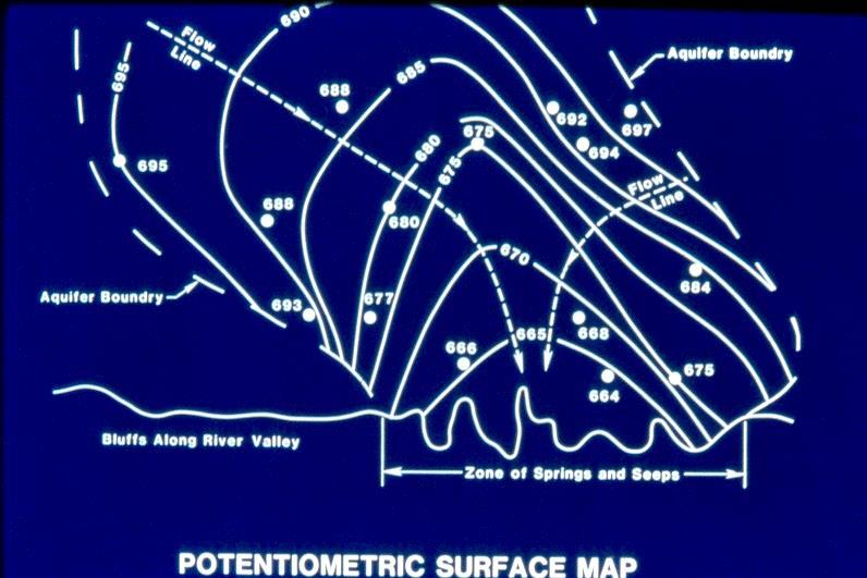
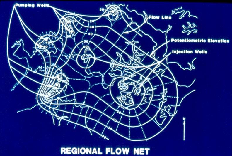
37 BASIC PRINCIPLES OF GW OCCURRENCE AND FLOW OUTLINE FOR THIS TALK WHAT IS GW? GEOLOGY AND GROUND WATER GW HYDROLOGY GROUND-WATER / SURFACE-WATER INTERACTION GROUND-WATER QUALITY 37

38 Q=KiA Ft/ft 38
39 39
40 40

41 Vertical flow most often less than horizontal flow but can be important in some hydrogeologic settings 41

42 Artesian 42
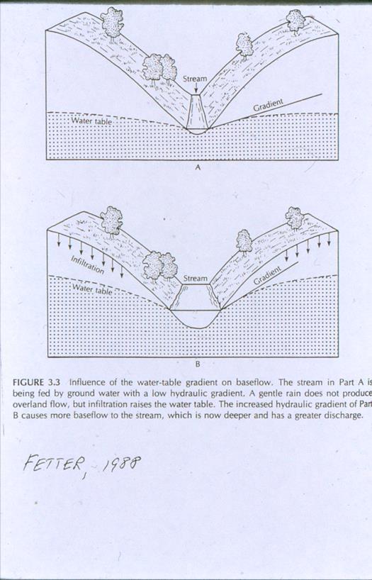
43 43
44 44

45 Water table /potentiometric surface maps should represent a single aquifer /flow system 45
46 MULTIPLE SCALE FLOW SYSTEMS Occur in hydrogeologic settings with complex topography and stratigraphy Vertical dimensions of flow systems Local - 100s of meters Intermediate -100s -1000s of meters Regional 1000s of meters to kilometers Source USGS PP 1423 C

47 Storage coefficient / specific yield The amount of water released per unit area of aquifer for a given unit head change Confined aquifer low sc Unconfined - high sy 47
48 BASIC PRINCIPLES OF GW OCCURRENCE AND FLOW OUTLINE FOR THIS TALK WHAT IS GW? GEOLOGY AND GROUND WATER GW HYDROLOGY GROUND-WATER / SURFACE-WATER INTERACTION GROUND-WATER QUALITY 48
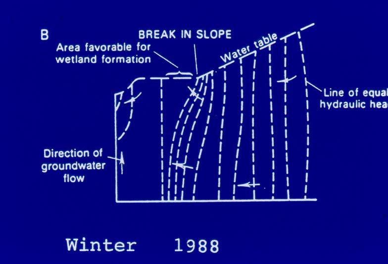
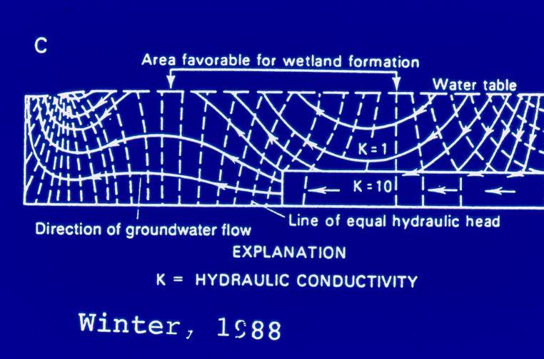
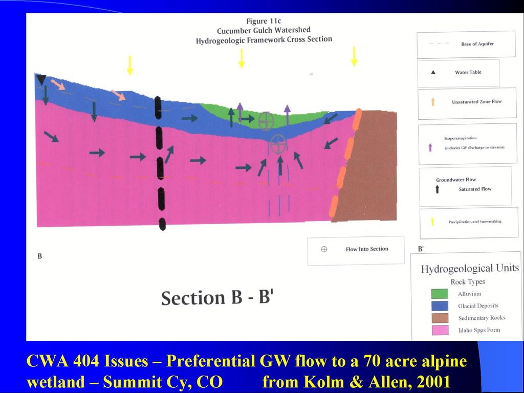
49 GROUND-WATER / SURFACE-WATER INTERACTION Aquifer stream interaction Hyphoreic zone Wetlands /fens Hillslope hydrology Springs 49
50 50

51 Gaining losing relationship can vary temporally & spatially 51
52 52

53 Base Flow 53
54 54

55 Hyporheic Zone 55

56 Hyporheic Zone 56

57 WETLANDS - Iron Bog Near Silverton, CO Most wetlands are GW discharge areas 57
58 58
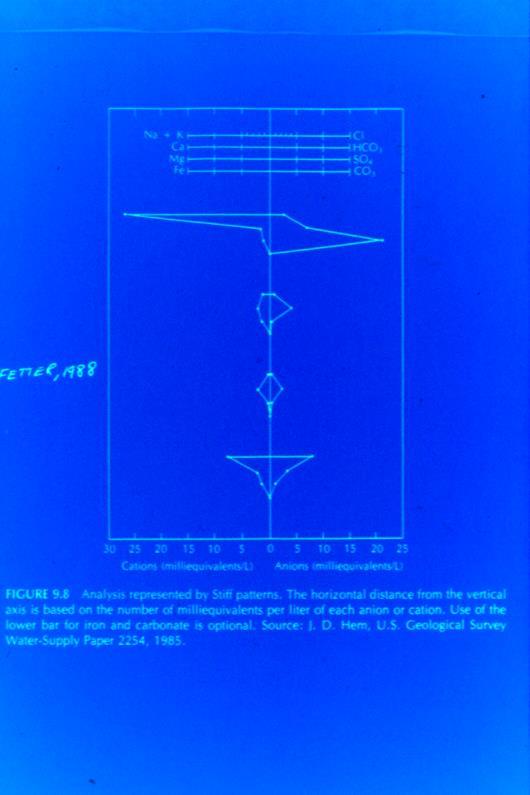
59 59
60 FENS SCANDANAVIAN WORD FOR WINDOW GW MOVING VERTICALLY UPWARD FROM A CONFINED AQUIFER THRU A CONFINING UNIT FLOW RATE AND CHEMISTRY ARE CONSTANT RESULTS IN A UNIQUE, HIGH QUALITY WETLAND SPECIES DIVERSITY 60
61 61

62 Sideslope fens 62

63 Interflow 63

64 SPRINGS 64
65 BASIC PRINCIPLES OF GW OCCURRENCE AND FLOW OUTLINE FOR THIS TALK WHAT IS GW? GEOLOGY AND GROUND WATER GW HYDROLOGY GROUND-WATER / SURFACE-WATER INTERACTION GROUND-WATER QUALITY 65
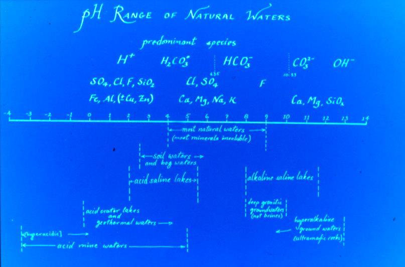
66 Natural Ground-Water Quality Nearly all GW originates as rain or snow that infiltrates to the saturated zone Infiltration through soil zone / vadose zone has great influence on chemistry of water Soil generates carbonic acid (H2CO3) and consumes dissolved oxygen 66
67 Natural Ground-Water Quality Chemistry of GW is controlled by rock-water interaction that occur as gw flows from areas of recharge to areas of discharge Increases in total dissolved solids and major ions Changes in dominant anions - HCO3 > SO4 > Cl Cation concentrations vary due to reactions 67
68 Natural Ground - Water Quality 1. Not well characterized 2. Varies depending on which portion of aquifer (Recharge area vs. discharge area) 3. Assessments typically based only on indicator parameters (TDS, SC) 4. Aquifer monitoring efforts (baseline, ambient) have been greatly reduced in the last decade 68
 Carbonic Acid (H2CO3) Minor constituents (> 0.")
69 Dissolved Constituents in GW Major constituents (> 5mg/l) Bicarbonate (HCO3) Calcium (Ca) Chloride (Cl) Magnesium (Mg) Silicon (Si) Sodium (Na) Sulfate (SO4) Carbonic Acid (H2CO3) Minor constituents (> mg/l) Boron (B) Carbonate (CO3) Fluoride (Fl) Iron (Fe) Nitrate (NO3) Potassium (K) Strontium (Sr) 69
70 Dissolved Constituents in GW Trace constituents (< 0.1 mg/l) Aluminum Antimony Arsenic Barium Cadmium Chromium Copper Lead Manganese Lithium Phosphate Radium Selenium Silver Uranium Zinc 70

71 Dissolved Constituents in GW Organics and gases Organic constituents Important species H2CO3, CO2, HCO3, CO3 Ubiquitous Mostly fulvic & humic acid Atmospheric gases N2, O2, CO2 Gases produced by anaerobic biochemical processes CH4, H2S, N2O 71
72 72

73 TOTAL DISSOLVED SOLIDS Classification for GW Fresh water mg/l Brackish water ,000 mg/l Saline water 10, ,000 mg/l Brine water - > 100,000 mg/l 73


74 Hardness The Content of Metallic Ions Which React With Sodium Soaps To form Scummy Residue Soft - < 60 mg/l Hard mg/l Very Hard - > 150 mg/l Water softening common when hardness > 80 mg/l Typically total concentration of Ca 2 +Mg 2 Expressed as mg/l equivalent CaCO3 GW in mountain watersheds underlain by granitic /metamorphic rocks is typically soft 74
75 75
76 Isotopes in GW Elements that have same # of protons in nucleus but different # of neutrons Same atomic # but different atomic weight Slightly different chemical properties Stable isotopes vs. radioisotopes Useful as tracers 76
77 Isotopes Commonly Used in Hydrogeology Isotope Symbol Molecule Type Half-life Deuterium D H 2 0 Stable --- Oxygen O H 2 0 Stable --- Tritium 3 H H 2 0 Radiogenic 12.7 years Sulfur- 35 (1) 35 S SO 4 2- Radiogenic 87 days Carbon C CO 2 Radiogenic 5730 yrs (1) Still in proof of concept 77
78 Isotopic Ratios for Oxygen Isotopic concentration are expressed as the difference the measured ratios of the sample and reference divided by the measured ratio of the reference. This is expressed using the delta (d) notation: 18 O / 16 O Ratio is changed by fractionation processes Snow depleted in 18 O ; rain enriched in 18 O 78

79 Tritium ( 3 H) In The Environment Produced by cosmic rays spallation of nitrogen Pre-bomb < 10TU in precip Nuclear weapons testing Up to 1000 TU in precip in Tritium in precip approaching pre-bomb levels GW mean residence times based on tritium < 0.8 TU recharged prior to TU modern (<5 to 10Yrs) > 30 TU Considerable % of recharge from 1960 s / 70 s > 50 TU Dominantly recharge 79
80 Uses for isotopic data Determine gw recharge areas Evaluate gw flowpaths Determine sources of TDS Relative age of gw (length of time that gw has been out of contact with atmosphere) 80
81 Water Quality Standards Standards established in USA and Western Europe for: Inorganic contaminants Pesticides/PCBs/Herbicides Volatile Organic Chemicals Other organic chemicals Radio-nuclides Microbiological Contaminants 81
82 Global GW Issues Central Valley CA (Colin, A, 2014) 160 km 3 of GW withdrawal in last 150 yrs (176 billion tons) More than 25 feet of subsidence increased rate in Resulted in annual uplift of 3mm /yr in California Coastal Ranges / southern Sierra Nevadas Also results in differential hydraulic pressures on fault planes mini-earthquakes Global withdrawals (Konikow, 2011) km 3 GW withdrawal = 12.6 mm sea level rise (> 6% of total) ave. 145 km 3 Off shore fresh GW (Post, et al, 2013) Large volumes of low-salinity GW beneath continental shelves due to recharge by meteoric water during low sealevel times 82

83 Ama Dablam Khumbu, Nepal THANK YOU! Mike Wireman
84 Hydrogeologic setting 84
11/22/2010. Groundwater in Unconsolidated Deposits. Alluvial (fluvial) deposits. - consist of gravel, sand, silt and clay
 deposits. - consist of gravel, sand, silt and clay") Groundwater in Unconsolidated Deposits Alluvial (fluvial) deposits - consist of gravel, sand, silt and clay - laid down by physical processes in rivers and flood plains - major sources for water supplies
Groundwater in Unconsolidated Deposits Alluvial (fluvial) deposits - consist of gravel, sand, silt and clay - laid down by physical processes in rivers and flood plains - major sources for water supplies
Chapter 13. Groundwater
 Chapter 13 Groundwater Introduction Groundwater is all subsurface water that completely fills the pores and other open spaces in rocks, sediments, and soil. Groundwater is responsible for forming beautiful
Groundwater Resources of Missouri. Cynthia Brookshire, R. G.
 Groundwater Resources of Missouri Cynthia Brookshire, R. G. GROUNDWATER... Water beneath the Earth s surface within a zone of saturation AQUIFER... A geologic formation or group of formations that are
Groundwater. (x 1000 km 3 /y) Reservoirs. Oceans Cover >70% of Surface. Groundwater and the. Hydrologic Cycle
 Reservoirs. Oceans Cover >70% of Surface. Groundwater and the. Hydrologic Cycle") Chapter 13 Oceans Cover >70% of Surface Groundwater and the Hydrologic Cycle Oceans are only 0.025% of Mass Groundwater Groundwater is liquid water that lies in the subsurface in fractures in rocks and
Chapter 13 Oceans Cover >70% of Surface Groundwater and the Hydrologic Cycle Oceans are only 0.025% of Mass Groundwater Groundwater is liquid water that lies in the subsurface in fractures in rocks and
Soils, Hydrogeology, and Aquifer Properties. Philip B. Bedient 2006 Rice University
 Soils, Hydrogeology, and Aquifer Properties Philip B. Bedient 2006 Rice University Charbeneau, 2000. Basin Hydrologic Cycle Global Water Supply Distribution 3% of earth s water is fresh - 97% oceans 1%
 12 10 8 6 4 2 0 40-50 50-60 60-70 70-80 80-90 90-100 Fresh Water What we will cover The Hydrologic Cycle River systems Floods Groundwater Caves and Karst Topography Hot springs Distribution of water in
Prof. Stephen A. Nelson EENS 111. Groundwater
 Page 1 of 8 Prof. Stephen A. Nelson EENS 111 Tulane University Physical Geology This page last updated on 20-Oct-2003 is water that exists in the pore spaces and fractures in rock and sediment beneath
GEOLOGY MEDIA SUITE Chapter 5
 UNDERSTANDING EARTH, SIXTH EDITION GROTZINGER JORDAN GEOLOGY MEDIA SUITE Chapter 5 Sedimentation Rocks Formed by Surface Processes 2010 W.H. Freeman and Company Mineralogy of sandstones Key Figure 5.12
Groundwater. (x 1000 km 3 /y) Oceans Cover >70% of Surface. Groundwater and the. Hydrologic Cycle
 Oceans Cover >70% of Surface. Groundwater and the. Hydrologic Cycle") Chapter 17 Oceans Cover >70% of Surface Groundwater and the Hydrologic Cycle Vasey s Paradise, GCNP Oceans are only 0.025% of Mass Groundwater Groundwater is liquid water that lies in the subsurface in
Chapter 17 Oceans Cover >70% of Surface Groundwater and the Hydrologic Cycle Vasey s Paradise, GCNP Oceans are only 0.025% of Mass Groundwater Groundwater is liquid water that lies in the subsurface in
What we will cover. The Hydrologic Cycle. River systems. Floods. Groundwater. Caves and Karst Topography. Hot springs
 Fresh Water What we will cover The Hydrologic Cycle River systems Floods Groundwater Caves and Karst Topography Hot springs On a piece of paper, put these reservoirs of water in to order from largest to
Example Quiz on Earthquakes
 Example Quizzes, Tests, and Review Information A Example Quiz on Earthquakes Quizzes such as this one are given at the beginning of each lab. 1. The point beneath the Earth s surface at which an earthquake
Sediment and sedimentary rocks Sediment
 Sediment and sedimentary rocks Sediment From sediments to sedimentary rocks (transportation, deposition, preservation and lithification) Types of sedimentary rocks (clastic, chemical and organic) Sedimentary
Connecticut's Aquifers
 Page 1 of 5 DEP Search: Connecticut's Aquifers The technical definition of the word "aquifer" is: any geologic formation capable of yielding significant quantities of water to wells. By that definition,
Lab 7: Sedimentary Structures
 Name: Lab 7: Sedimentary Structures Sedimentary rocks account for a negligibly small fraction of Earth s mass, yet they are commonly encountered because the processes that form them are ubiquitous in the
Name. 4. The diagram below shows a soil profile formed in an area of granite bedrock. Four different soil horizons, A, B, C, and D, are shown.
 Name 1. In the cross section of the hill shown below, which rock units are probably most resistant to weathering? 4. The diagram below shows a soil profile formed in an area of granite bedrock. Four different
Groundwater Hydrology
 EXERCISE 12 Groundwater Hydrology INTRODUCTION Groundwater is an important component of the hydrologic cycle. It feeds lakes, rivers, wetlands, and reservoirs; it supplies water for domestic, municipal,
Michigan s Geology and Groundwater
 Michigan s Geology and Groundwater Ralph J. Haefner Deputy Director U.S. Geological Survey Michigan-Ohio Water Science Center Lansing, Michigan Outline About the USGS Geology 101 Michigan s geology Bedrock
Geology 229 Engineering Geology. Lecture 6. Basic Rock Classification and Engineering Considerations (West, Chs. 2, 3, 4, 5)
") Geology 229 Engineering Geology Lecture 6 Basic Rock Classification and Engineering Considerations (West, Chs. 2, 3, 4, 5) Outline of this Lecture 1. Rock types and rock cycle 2. Geological and engineering
Geology 229 Engineering Geology Lecture 6 Basic Rock Classification and Engineering Considerations (West, Chs. 2, 3, 4, 5) Outline of this Lecture 1. Rock types and rock cycle 2. Geological and engineering
1/31/2013. Weathering Includes Physical, Chemical, Biological processes. Weathering Mechanisms. Wind abrasion forming Ventifacts
 Monument Valley, Utah. What weathering processes contributed to the development of these remarkable rock formations? Weathering Includes Physical, Chemical, Biological processes Weathering Mechanisms Physical
STUDY GUIDE FOR CONTENT MASTERY. Movement and Storage of Groundwater
 Groundwater SECTION 10.1 Movement and Storage of Groundwater In your textbook, read about the hydrosphere, precipitation and groundwater, and groundwater storage. Use the following terms to complete the
Sedimentology & Stratigraphy. Thanks to Rob Viens for slides
 Sedimentology & Stratigraphy Thanks to Rob Viens for slides Sedimentology The study of the processes that erode, transport and deposit sediments Sedimentary Petrology The study of the characteristics and
Salinity. foot = 0.305m yard = 0.91m. Length. Area m 2 square feet ~0.09m2. Volume m 3 US pint ~ 0.47 L fl. oz. ~0.02 L.
 Length m foot = 0.305m yard = 0.91m Area m 2 square feet ~0.09m2 Volume m 3 US pint ~ 0.47 L, L (liters) fl. oz. ~0.02 L Speed m/s mph Acceleration m/s 2 mph/s Weight kg, gram pound ~0.45kg Temperature
Practice Test Rocks and Minerals. Name. Page 1
 Name Practice Test Rocks and Minerals 1. Which rock would be the best source of the mineral garnet? A) basalt B) limestone C) schist D) slate 2. Which mineral is mined for its iron content? A) hematite
Salinity. See Appendix 1 of textbook x10 3 = See Appendix 1 of textbook
 Length Area Volume m m m foot = 0.305m yard = 0.91m square feet ~0.09m2 US pint ~ 0.47 L fl. oz. ~0.02 L Speed m/s mph Acceleration m/s mph/s Weight kg, gram pound ~0.45kg Temperature o o See Appendix
As compaction and cementation of these sediments eventually occur, which area will become siltstone? A) A B) B C) C D) D
 A B) B C) C D) D") 1. A student obtains a cup of quartz sand from a beach. A saltwater solution is poured into the sand and allowed to evaporate. The mineral residue from the saltwater solution cements the sand grains together,
1. A student obtains a cup of quartz sand from a beach. A saltwater solution is poured into the sand and allowed to evaporate. The mineral residue from the saltwater solution cements the sand grains together,
Mammoth Cave National Park, Kentucky
 Mammoth Cave National Park, Kentucky Objectives of Today s Lecture Refresher on Sedimentary Depositional Systems and Rock Classifications Transgressive and Regressive Marine Environments Carbonate Depositional
WEATHERING, EROSION & DEPOSITION STUDY GUIDE
 WEATHERING, EROSION & DEPOSITION STUDY GUIDE Weathering: The difference between mechanical & chemical weathering is: Sort terms as being mechanical/physical or chemical weathering: acid rain, root splitting
Lecture Outline Wednesday - Friday February 14-16, 2018
 Lecture Outline Wednesday - Friday February 14-16, 2018 Quiz 2 scheduled for Friday Feb 23 (Interlude B, Chapters 6,7) Questions? Chapter 6 Pages of the Past: Sedimentary Rocks Key Points for today Be
Surface Processes Focus on Mass Wasting (Chapter 10)
") Surface Processes Focus on Mass Wasting (Chapter 10) 1. What is the distinction between weathering, mass wasting, and erosion? 2. What is the controlling force in mass wasting? What force provides resistance?
Surface Processes Focus on Mass Wasting (Chapter 10) 1. What is the distinction between weathering, mass wasting, and erosion? 2. What is the controlling force in mass wasting? What force provides resistance?
THE ROCK CYCLE & ROCKS. Subtitle
 THE ROCK CYCLE & ROCKS Subtitle 3. Three rocks that do not have minerals or are composed of nonmineral matter. Coal Pumuce Obsidian THE ROCK CYCLE Why do scientists study rocks? Rocks contain clues about
1. are most likely to study the images sent back from Mars. A. Astronomers B. Geologists C. Doctors D. Engineers
 1. are most likely to study the images sent back from Mars. A. Astronomers B. Geologists C. Doctors D. Engineers 2. When did the Earth form? A. About 540 million years ago B. About 2.5 billion years ago
Evolution of the conceptual hydrogeologic and ground-water flow model for Las Vegas Valley, Clark County, Nevada
 Evolution of the conceptual hydrogeologic and ground-water flow model for Las Vegas Valley, Clark County, Nevada Geological Society of America Annual Meeting November 14, 2 David J. Donovan Southern Nevada
Section I: Multiple Choice Select the best answer to each question. Mark your final answer on the answer sheet. (1 pt each)
") Sedimentary Rocks & Surface Processes Quest Name: Earth Science 2013 Block: Date: Section I: Multiple Choice Select the best answer to each question. Mark your final answer on the answer sheet. (1 pt each)
Sedimentary Rocks & Surface Processes Quest Name: Earth Science 2013 Block: Date: Section I: Multiple Choice Select the best answer to each question. Mark your final answer on the answer sheet. (1 pt each)
GEOL Introductory Geology: Exploring Planet Earth Fall 2010 Test #2 October 18, 2010
 GEOL 101 - Introductory Geology: Exploring Planet Earth Fall 2010 Test #2 October 18, 2010 Name KEY ID# KEY Multiple choice questions (2 points each). 1. What type of metamorphic rock is formed over large
Mark S. Nordberg Geology and Groundwater Investigations Section North Central Region Office California Department of Water Resources
 Mark S. Nordberg Geology and Groundwater Investigations Section North Central Region Office California Department of Water Resources Ukiah Drought Workshop July 29, 2009 Groundwater 101 Groundwater is
Where is all the water?
 Where is all the water? The distribution of water at the Earth's surface % of total Oceans 97.25 Ice caps and glaciers 2.05 Groundwater 0.68 Lakes 0.01 Soils 0.005 Atmosphere (as vapour) 0.001 Rivers 0.0001
LAB 2 IDENTIFYING MATERIALS FOR MAKING SOILS: ROCK AND PARENT MATERIALS
 LAB 2 IDENTIFYING MATERIALS FOR MAKING SOILS: ROCK AND PARENT MATERIALS Learning outcomes The student is able to: 1. understand and identify rocks 2. understand and identify parent materials 3. recognize
Understanding Earth Fifth Edition
 Understanding Earth Fifth Edition Grotzinger Jordan Press Siever Chapter 5: SEDIMENTATION: Rocks Formed by Surface Processes Lecturer: H Mohammadzadeh Assistant professors, Department of Geology, FUM Copyright
Pratice Surface Processes Test
 1. The cross section below shows the movement of wind-driven sand particles that strike a partly exposed basalt cobble located at the surface of a windy desert. Which cross section best represents the
CEE 437 Lecture 10 Rock Classification. Thomas Doe
 CEE 437 Lecture 10 Rock Classification Thomas Doe Igneous Origins Intrusive Batholithic or plutonic: phaneritic Dikes or sills that chill rapidly: aphanitic Extrusive deposition as melt (lava) pyroclastic
Chapter 2. Regional Landscapes and the Hydrologic Cycle
 Chapter 2. Regional Landscapes and the Hydrologic Cycle W. Lee Daniels Department of Crop and Soil Environmental Sciences, Virginia Tech Table of Contents Introduction... 23 Soils and landscapes of the
ENVI.2030L Geologic Time
 Name ENVI.2030L Geologic Time I. Introduction There are two types of geologic time, relative and absolute. In the case of relative time geologic events are arranged in their order of occurrence. No attempt
Figure 1 The map shows the top view of a meandering stream as it enters a lake. At which points along the stream are erosion and deposition dominant?
 1. In which type of climate does chemical weathering usually occur most rapidly? 1. hot and dry 3. cold and dry 2. hot and wet 4. cold and wet 2. Figure 1 The map shows the top view of a meandering stream
Hydrogeology of East-Central Union County, Northeastern New Mexico
 Hydrogeology of East-Central Union County, Northeastern New Mexico Geoffrey Rawling April 2013 New Mexico Bureau of Geology & Mineral Resources 1 What are the important hydrogeologic issues in Union County?
UNIT 4 SEDIMENTARY ROCKS
 UNIT 4 SEDIMENTARY ROCKS WHAT ARE SEDIMENTS Sediments are loose Earth materials (unconsolidated materials) such as sand which are transported by the action of water, wind, glacial ice and gravity. These
Geoscience 001 Fall Rock Identification and Contextual Interpretation
 Geoscience 00 Fall 2005 Rock Identification and Contextual Interpretation The purpose of this week s lab is to gain some more experience and practice in identifying rocks and then interpreting the geologic
Name: Which rock layers appear to be most resistant to weathering? A) A, C, and E B) B and D
 A, C, and E B) B and D") Name: 1) The formation of soil is primarily the result of A) stream deposition and runoff B) precipitation and wind erosion C) stream erosion and mass movement D) weathering and biological activity 2)
Name: 1) The formation of soil is primarily the result of A) stream deposition and runoff B) precipitation and wind erosion C) stream erosion and mass movement D) weathering and biological activity 2)
CEE 437 Lecture 11 Rock Classification. Thomas Doe
 CEE 437 Lecture 11 Rock Classification Thomas Doe Translation of Mineral Properties to Rock Properties Comparison of mineral properties to rock properties Rocks have lower strength, especially tensile
Emily and Megan. Earth System Science. Elements of Earth by weight. Crust Elements, by weight. Minerals. Made of atoms Earth is mostly iron, by weight
 Emily and Megan Chapter 20 MINERALS AND ROCKS Earth System Science Interconnected Rocks and minerals Interior processes Erosion and deposition Water and air Elements of Earth by weight Made of atoms Earth
Unit 3 Review - Surface Processes
 Unit 3 Review - Surface Processes 1. Why is the surface of Mercury covered with meteor impact craters, while Earth s surface has relatively few craters? A) Mercury is larger than Earth, so it gets hit
Sedimentary Environments Chapter 8
 Sedimentary Environments Chapter 8 Does not contain complete lecture notes. To be used to help organize lecture notes and home/test studies. What is a sedimentary rock? Sedimentary rocks are products of
Why Study Groundwater?
 Groundwater Water filling open spaces in rock, sediment, and soil beneath the surface is called groundwater. This natural resource is as important to human endeavors as surface water. Groundwater is an
WEATHERING. Turning Rock to Sediment and Solutions 10/22/2012
 WEATHERING Turning Rock to Sediment and Solutions Igneous rocks form at high temperatures; at the Earth s surface they are chemically unstable and will begin to disintegrate and decompose in a process
Lab 9: Petroleum and groundwater
 Geology 101 Name(s): Lab 9: Petroleum and groundwater Petroleum (oil) is a multi-component liquid refined to generate different hydrocarbons, such as heptane (a component of gasoline) and waxes. For the
Chapter 6 Sedimentary and Metamorphic Rock
 Chapter 6 Sedimentary and Metamorphic Rock Weathering and Erosion Wherever rock is exposed at Earth s surface, it is continuously being broken down by weathering a set of physical and chemical processes
Minerals and Rocks Chapter 20
 Minerals and Rocks Chapter 20 Emily and Megan Earth System Science Interconnected Rocks and minerals Interior processes Erosion and deposition Water and air Elements of Earth by weight Made of atoms Earth
Page 1. Name:
 Name: Questions 1 through 3 refer to the following: The diagrams below represent two rock outcrops found several miles apart in New York State. Individual rock layers are lettered, and fossils and rock
1. Base your answer to the following question on The diagram below represents a part of the crystal structure of the mineral kaolinite.
 1. Base your answer to the following question on The diagram below represents a part of the crystal structure of the mineral kaolinite. An arrangement of atoms such as the one shown in the diagram determines
A. IGNEOUS Rocks formed by cooling and hardening of hot molten rock called magma (within crust or at its surface).
.") EARTH SCIENCE 11 CHAPTER 5 NOTES KEY How Earth's Rocks Were Formed Early geologists believed that the physical features of the Earth were formed by sudden spectacular events called CATASTROPHES. Modern
EARTH SCIENCE 11 CHAPTER 5 NOTES KEY How Earth's Rocks Were Formed Early geologists believed that the physical features of the Earth were formed by sudden spectacular events called CATASTROPHES. Modern
1. The diagram below shows the stump of a tree whose root grew into a small crack in bedrock and split the rock apart.
 1. The diagram below shows the stump of a tree whose root grew into a small crack in bedrock and split the rock apart. 4. Which process involves either a physical or chemical breakdown of earth materials?
What is a sedimentary rock?
 Sedimentary Rocks What is a sedimentary rock? Sedimentary rocks are products of mechanical and chemical weathering They account for only 5% of the top 10 miles of the outer crust, yet most of the earth
RIVERS, GROUNDWATER, AND GLACIERS
 RIVERS, GROUNDWATER, AND GLACIERS Delta A fan-shaped deposit that forms when a river flows into a quiet or large body of water, such as a lake, an ocean, or an inland sea. Alluvial Fan A sloping triangle
Sediments and Sedimentary Rocks
 Sediments and Sedimentary Rocks (Shaping Earth s Surface, Part 2) Science 330 Summer 2005 What is a sedimentary rock? Products of mechanical and chemical weathering Account for about 5 percent of Earth
Which rock is shown? A) slate B) dunite C) gneiss D) quartzite
 slate B) dunite C) gneiss D) quartzite") 1. Which metamorphic rock will have visible mica crystals and a foliated texture? A) marble B) quartzite C) schist D) slate 2. The recrystallization of unmelted material under high temperature and pressure
1. Which metamorphic rock will have visible mica crystals and a foliated texture? A) marble B) quartzite C) schist D) slate 2. The recrystallization of unmelted material under high temperature and pressure
Environmental Isotopes in Hydrogeology. land. Clark and Peter Fritz
 Environmental Isotopes in Hydrogeology land. Clark and Peter Fritz www. science.uottawa. ca/~eih LEWIS PUBLISHERS Boca Raton New York CONTENTS CHAPTER 1: THE ENVIRONMENTAL ISOTOPES 1 Environmental Isotopes
Essentials of Geology, 11e
 Essentials of Geology, 11e Groundwater Chapter 10 Instructor Jennifer Barson Spokane Falls Community College Geology 101 Stanley Hatfield Southwestern Illinois Co Jennifer Cole Northeastern University
STUDY GUIDE FOR CONTENT MASTERY. Surface Water Movement
 Surface Water SECTION 9.1 Surface Water Movement In your textbook, read about surface water and the way in which it moves sediment. Complete each statement. 1. An excessive amount of water flowing downslope
Evolution of the Earth
 Evolution of the Earth http://static.newworldencyclopedia.org/f/fe/geologic_clock.jpg Evolution of the Earth Solar system, 4.6 byr Collapse of a nebula Star forms as gravity concentrates material at center
Sedimentary Rocks. Weathering. Mechanical & Chemical Weathering. Sediments. Lithification. Deposition. Transport. Erosion.
 Lithification Sedimentary Rocks Sediments Deposition Transport Erosion Weathering Weathering The sediments that make up sedimentary rocks are produced by: Mechanical & Chemical Weathering Mechanical Weathering
Module 10: Resources and Virginia Geology Topic 4 Content: Virginia Geology Notes
 Virginia is composed of a very diverse landscape that extends from the beaches and barrier islands all of the way to the highly elevated Appalachian Plateau. Geologists have discovered ancient shallow
R.Suhasini., Assistant Professor Page 1
 UNIT I PHYSICAL GEOLOGY Geology in civil engineering branches of geology structure of earth and its composition weathering of rocks scale of weathering soils - landforms and processes associated with river,
Name Class Date. In your textbook, read about the nature of igneous rocks. Use each of the terms below just once to complete the following statements.
 CHAPTER 5 Igneous Rocks SECTION 5.1 What are igneous rocks? In your textbook, read about the nature of igneous rocks. Use each of the terms below just once to complete the following statements. basaltic
Geology and New England Landscapes
 Geology and New England Landscapes Jim Turenne, CPSS USDA-NRCS Warwick, RI. http://nesoil.com Why Geology? Provides the big picture of site conditions. Major part of soil formation (parent material and
Hydrogeology of Karst NE Wisconsin. Dr. Maureen A. Muldoon UW-Oshkosh Geology Department
 Hydrogeology of Karst NE Wisconsin Dr. Maureen A. Muldoon UW-Oshkosh Geology Department WI Bedrock Outline Karst Landscapes Existing WQ Data Flow in Karst Aquifers Overview of Silurian Aquifer Water Level
Geology of the Hawaiian Islands
 Geology of the Hawaiian Islands Class 12 19 February 2004 A B C D F 97 94 92 91 88 87 86 85 85 84 82 77 73 73 mean 66 64 60 69 60 57 51 29 Exam Scores Mean = 71 Median = 82/77 Any Questions? Sedimentary
Lecture Outlines PowerPoint. Chapter 5 Earth Science 11e Tarbuck/Lutgens
 Lecture Outlines PowerPoint Chapter 5 Earth Science 11e Tarbuck/Lutgens 2006 Pearson Prentice Hall This work is protected by United States copyright laws and is provided solely for the use of instructors
Wisconsin s Hydrogeology: an overview
 2012 Soil and Water Conservation Society Conference Stevens Point, WI Feb 9, 2012 Wisconsin s Hydrogeology: an overview Ken Bradbury Wisconsin Geological and Natural History Survey University of Wisconsin-Extension
Chapter 8 Fetter, Applied Hydrology 4 th Edition, Geology of Groundwater Occurrence
 Chapter 8 Fetter, Applied Hydrology 4 th Edition, 2001 Geology of Groundwater Occurrence Figure 8.42. Alluvial Valleys ground-water region. Fetter, Applied Hydrology 4 th Edition, 2001 Fetter, Applied
The most common elements that make up minerals are oxygen, silicon, aluminum, iron, calcium, potassium, and magnesium
 Mineralogy: The Study of Minerals and their Properties A Mineral! Occurs! Is a! Is a substance (element or compound)! Has atoms arrange in an orderly pattern ( )! Is (not formed by any process involving
Follow this and additional works at: Part of the Geology Commons
 Western Michigan University ScholarWorks at WMU Michigan Geological Repository for Research and Education Geosciences 2016 Geology of Michigan William B. Harrison III Michigan Geological Repository for
SOIL MECHANICS SAB1713 DR. HETTY
 SOIL MECHANICS SAB1713 DR. HETTY INTRODUCTION SOIL MECHANICS -Concerned solely with soils -Concerned with the deformation and strength of bodies of soils -Concerned with the interaction of structures with
1. The map below shows a meandering river. A A' is the location of a cross section. The arrows show the direction of the river flow.
 1. The map below shows a meandering river. A A' is the location of a cross section. The arrows show the direction of the river flow. Which cross section best represents the shape of the river bottom at
A MULTIPLE TRACER / GEOCHEMICAL APPROACH TO
 A MULTIPLE TRACER / GEOCHEMICAL APPROACH TO CHARACTERIZING WATER AND CONTAMINANT MOVEMENT THROUGH ABANDONED MINE WORKINGS NEAR RICO, COLORADO Mike Wireman, Region 8, U.S. EPA, Denver, CO; Rory Cowie, University
Page 1. Name: Period: Date: WS Metamorphic Rocks. The diagram below represents a rock with a distorted layer structure.
 Name: Period: Date: 9317-1 - Page 1 WS Metamorphic Rocks 1) The diagram below represents a rock with a distorted layer structure. 5) Which rock is most likely a nonsedimentary rock? A) a rock showing mud
Arsenic and Other Trace Elements in Groundwater in the Southern San Joaquin Valley of California
 Arsenic and Other Trace Elements in Groundwater in the Southern San Joaquin Valley of California Dirk Baron Geological Sciences California State University, Bakersfield Trace Element Maximum Contaminant
1.72, Groundwater Hydrology Prof. Charles Harvey Lecture Packet #5: Groundwater Flow Patterns. Local Flow System. Intermediate Flow System
 1.72, Groundwater Hydrology Prof. Charles Harvey Lecture Packet #5: Groundwater Flow Patterns c Local Flow System 10,000 feet Intermediate Flow System Regional Flow System 20,000 feet Hydrologic section
Rocks and the Rock Cycle notes from the textbook, integrated with original contributions
 Rocks and the Rock Cycle notes from the textbook, integrated with original contributions Alessandro Grippo, Ph.D. Gneiss (a metamorphic rock) from Catalina Island, California Alessandro Grippo review Rocks
NC Earth Science Essential Standards
 NC Earth Science Essential Standards EEn. 2.1 Explain how processes and forces affect the Lithosphere. EEn. 2.1.1 Explain how the rock cycle, plate tectonics, volcanoes, and earthquakes impact the Lithosphere.
6.1 Water. The Water Cycle
 6.1 Water The Water Cycle Water constantly moves among the oceans, the atmosphere, the solid Earth, and the biosphere. This unending circulation of Earth s water supply is the water cycle. The Water Cycle
Earth Science Chapter 6 Rocks
 Earth Science Chapter 6 Rocks I. Rocks and the Rock Cycle * Material that makes up the solid part of the Earth. * Made of a variety of different combinations of minerals and organic matter. A. Three Major
The Nature of Sedimentary Rocks
 The Nature of Sedimentary Rocks Sedimentary rocks are composed of: Fragments of other rocks Chemical precipitates Organic matter or biochemically produced materials The Nature of Sedimentary Rocks Sedimentary
Contents. 1 Introduction Stable Isotopes
 Contents 1 Introduction... 1 Part I Stable Isotopes 2 Isotope Geochemistry of Natural Waters... 11 2.1 Some Properties of Waters and Solutions... 11 2.1.1 The Notion of Activity and the Activity Coefficient...
2014 Chemistry 1 st Semester Exam Review Packet
 Name: Date: Hour: 2014 Chemistry 1 st Semester Exam Review Packet 1. What percentage of the water on Earth is salt water? (1 point) A. 97.2% B. 0.009% C. 2.11% D. 2.8 % 2. One similarity between all mixtures
Sedimentary Rocks. Origin, Properties and Identification. Physical Geology GEOL 101 Lab Ray Rector - Instructor
 Sedimentary Rocks Origin, Properties and Identification Physical Geology GEOL 101 Lab Ray Rector - Instructor Sedimentary Rock Origin and Identification Lab Pre-Lab Internet Link Resources 1) http://www.rockhounds.com/rockshop/rockkey/index.html
Topic 6: Weathering, Erosion and Erosional-Deposition Systems (workbook p ) Workbook Chapter 4, 5 WEATHERING
 Workbook Chapter 4, 5 WEATHERING") Topic 6: Weathering, Erosion and Erosional-Deposition Systems (workbook p. 95-125) Workbook Chapter 4, 5 THE BIG PICTURE: Weathering, erosion and deposition are processes that cause changes to rock material
Topic 6: Weathering, Erosion and Erosional-Deposition Systems (workbook p. 95-125) Workbook Chapter 4, 5 THE BIG PICTURE: Weathering, erosion and deposition are processes that cause changes to rock material
A Sedimentary Rock is..
 Sedimentary Rocks A Sedimentary Rock is.. rock formed from the lithification or crystallization of: 1. Minerals in solution 2. Organic remains 3. Materials produced by living things (biochemical) 4. Clastic
Rocks. Rocks are composed of 1 or more minerals. Rocks are classified based on how they formed (origin). 3 classes of rocks:
. 3 classes of rocks:") ROCKS Rocks If a mineral is a naturally occurring homogeneous solid, inorganically formed, with a definite chemical composi:on and a crystalline structure then what is a rock? Rocks Rocks are composed
ROCKS Rocks If a mineral is a naturally occurring homogeneous solid, inorganically formed, with a definite chemical composi:on and a crystalline structure then what is a rock? Rocks Rocks are composed
PENNSYLVANIA. Ordinary processes at Earth's surface and just below it cause rocks to change and soils to form. Page 1 of 3. S8.A.1.1.
 Know: Understand: Do: S8.D.1.1.1 -- Essential Explain the rock cycle as changes in the solid earth and rock types found in Pennsylvania (igneous - granite, basalt, obsidian, pumice, ; sedimentary - limestone,
EROSION, DEPOSITION AND SEDIMENTARY ROCKS. Reading: Earth Science Tarbuck and Lutgens Chapter 5: pages Chapter 3: pages 52-54, 61-69
 EROSION, DEPOSITION AND SEDIMENTARY ROCKS Reading: Earth Science Tarbuck and Lutgens Chapter 5: pages 124-133 Chapter 3: pages 52-54, 61-69 Base Level Resistant bed Resistant bed creates a local base level