Why Study Groundwater?
|
|
|
- Katherine Hill
- 5 years ago
- Views:
Transcription
1 Groundwater Water filling open spaces in rock, sediment, and soil beneath the surface is called groundwater. This natural resource is as important to human endeavors as surface water. Groundwater is an especially important resource in semiarid regions and played a pivotal role in westward expansion of the U.S. in the 19th century. Many legal battles have resulted from claims and counterclaims of groundwater ownership. In addition to being a source of freshwater, groundwater is an important erosional agent as well as an alternative energy source (geothermal energy).
2 Why Study Groundwater? Agricultural, industrial, and domestic demands for freshwater is at an all time high. Demands for groundwater have depleted supplies in many areas and led to ground subsidence and saltwater intrusion. In other areas pollution from landfills, toxic waste, and agriculture has made portions of the groundwater supply unsafe. As global population and industrialization expand, so will the demand for clean, safe groundwater. To assure the needs of future generations are meet, people must become aware of the value and vulnerability of our groundwater resources.
3 Groundwater & the Hydrologic Cycle Groundwater is one of the several reservoirs of the hydrologic cycle. Groundwater comprises ~8.4 million km 3 of the world s supply of freshwater. Water enters the groundwater reservoir via several pathways: ground infiltration of precipitation as well as infiltration from streams, lakes, swamps, artificial recharge ponds and water treatment systems. Movement of groundwater through the tiny pores of soil, sediment, and rock filters out many impurities such as disease-causing microorganisms and pollutants.

4 Water in the hydrosphere Chernicoff & Whitney (2002)

5 Groundwater 98% of the earth s unfrozen fresh water exists as groundwater 40% of the public water supply in the US is derived from groundwater 34 of the largest 100 cities in the US depend entirely on groundwater, a reflection of the fact that it is the cheapest source of municipal water Marshak (2002)
6 Some definitions Porosity proportion of void space within or between mineral grains Permeability measure of how readily a fluid passes through the material (hydraulic conductivity) Aquitard a rock that may store water but in which water flow is slowed Aquiclude a rock that is impermeable, an extreme aquitard. This term is not commonly used today

7 Porosity Wicander and Monroe (2002) Porosity is the percentage of the material s total volume that is pore space and determines the amount of groundwater a material can hold. Types of porosity are: intergranular solution fracture Sorting affects the volume of intergranular porosity. Well-sorted deposits have greater porosity

8 Permeability Permeability is the capacity of a material to transmit fluids. Permeability depends on pore size and interconnectedness. Marshak (2002)

9 What is interconnectedness? Chernicoff and Whitney (2002)

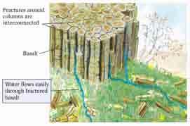
10 Permeability A permeable layer transporting groundwater is an aquifer. Sand and gravel deposits, fractured granite, and limestone with solution cavities are good aquifers. Impermeable materials that prevent groundwater movement are known as aquicludes. Shale and unfractured igneous and metamorphic rocks are examples of aquicludes. Porosity and permeability together control groundwater movement and recoverability. Marshak (2002)

11 Porosity and permeability Marshak (2002)
12 Porosity and permeability MATERIALS POROSITY Unconsolidated Sediment Soil 55% Gravel 20-40% Sand 25-50% Silt 35-50% Clay 50-70% Rocks Sandstone 5-30% Shale 0-10% Solution activity in limestone and dolostone 10-30% Fractured basalt 5-40% Fractured granite 10%

")
13 Porosity of sedimentary rocks. Chernicoff and Whitney (2002) Marshak (2002)


14 Surface distribution of water. The elevation of the water table is a subdued replica of the land surface; higher beneath hills and lowest beneath valleys. Surface tension produces the capillary fringe. The small amount of water adhering to particles in the zone of aeration is known as suspended water. Excellent diagram: pg 401 text Chernicoff and Whitney (2002) Marshak (2002)

15 Moisture through trees Only the water that infiltrates the soil that will contribute to groundwater Chernicoff and Whitney (2002)
")
16 Factors affecting infiltration. Chernicoff and Whitney (2002)
17 Aquifers: pg 407 text A saturated body of rock or soil that transmits economically significant quantities of groundwater. The most IMPORTANT property of an aquifer is it s HYDRAULIC CONDUCTIVITY, for it is the rate at which water can move to the screen of a pumping well to replace the water pumped out that determines the yield of a well. Hydraulic conductivity: the ease at which water or fluid will move through pore spaces or fractures Either confined or unconfined aquifers

18 Aquifers (pg 407 text) Unconfined aquifers are formations that are exposed to atmospheric pressure changes. They may be recharged by infiltration over the whole area underlain by the aquifer. These often occur in surficial deposits of sand and gravel. Confined aquifers are bounded above and below by low permeability rocks. These act as water conduits. The difference in water pressure between the top and bottom of the aquifer is known as the hydraulic head Plummer et al. (1997)
19 Residence time the amount of time that groundwater is present in an aquifer as it moves from the recharge area to the discharge area. In unconfined aquifers: days In confined aquifers: up to millions of years (in deep sedimentary basins) Figure pg 411 text.

20 Aquifers - complications Perched water tables false indications of the depth to the water table and the quantities available Marshak (2002)

21 Aquifers Need to know flow paths and recharge zones in order to calculate how much water can be safely extracted. For example high extraction rates close to the recharge area are more likely to be a problem than if they occur further down the flow path. Marshak (2002)

22 Groundwater extraction The sustained yield is the amount of water an aquifer can yield on a day-to-day basis over a long period of time without depleting the resource Marshak (2002)

 to areas of low pressure (rivers and")
23 How Does Groundwater Move? Groundwater flow is driven by gravity as is surface water flow. Movement through the zone of saturation is from areas of high pressure (beneath hills) to areas of low pressure (rivers and swamps). Chernicoff and Whitney (2002)
 h =")
")
24 Groundwater distribution (pg 397 text) h = hydraulic head (a fancy term for water level ) Marshak (2002)

25 Hydraulic (energy) gradient Chernicoff and Whitney (2002)

26 Potentiometric contours Well data is used to measure the depth to the water table Arrows indicate flow directions Pipkin and Trent (1997)

27 Discharge Discharge refers to the removal of water and takes place where groundwater flows into streams, lakes, swamps, and springs, or is withdrawn at water wells Wicander and Monroe (2002)

28 Recharge Recharge is the addition of water by infiltration of precipitation, snow melt, stream water, or water from artificial recharge ponds or water treatment systems. The water table rises or falls based on the ratio of recharge to discharge. Wicander and Monroe (2002)


29 Springs Springs are formed when groundwater flows laterally to intersect the land surface and is discharged Springs form where solution cavities, fractures, or perched water tables intersect the ground surface. Wicander and Monroe (2002)


30 Natural Springs Chernicoff and Whitney (2002)
 A similar")

31 Natural Springs (continued) A similar diagram is on page 406 of your text. Chernicoff and Whitney (2002)

32 Water Wells Water wells are openings, either dug or drilled, that connect the zone of saturation with Earth s surface. Water flows into the well cavity, filling it to the level of the water table. In the vicinity of a well, the water table is lowered, forming a cone of depression if water withdrawal exceeds the rate of inflow. Chernicoff and Whitney (2002)
")
33 Water wells (Cone of depression, pg text) If groundwater withdrawal is great, a large cone of depression can form such that the water table is lowered sufficiently to cause adjacent wells to go dry. Wicander and Monroe (2002)

34 Water Wells Many factors determine whether or not a water well will be successful. Among these factors are: distribution & type of rocks present, their porosity & permeability, fracture patterns, well depth, etc. Wicander and Monroe (2002)

35 Artesian Systems Artesian systems form where groundwater in sloping aquifers is confined by an overlying aquiclude. If recharge is sufficient to keep the aquifer filled, hydrostatic pressure builds up and allows groundwater to rise above the top of the aquifer in wells Wicander and Monroe (2002)

36 Desert oases Chernicoff and Whitney (2002)
37 Erosion and deposition Rainwater seeping through Earth materials to join the groundwater system causes chemical weathering of the minerals it contacts. In areas underlain by soluble rocks such as limestone, groundwater is an important agent of erosion, via chemical weathering, and responsible for formation of many landscape features. Groundwater erosion in areas underlain by limestone produces a characteristic landscape known as karst topography.
")
38 Sinkholes & Karst Topography Landscapes with karst topography are characterized by numerous sinkholes, solution valleys, disappearing streams, caves, springs. Karst topography forms in humid and temperate climates. Wicander and Monroe (2002)

39 Sinkholes Sinkholes are depressions of various size and shape on the ground surface of regions underlain by soluble rock. Sinkholes can form by collapse of cave roofs and pose a serious hazard in populated areas. Sinkholes can also form from the surface downward as openings in soluble rock are progressively enlarged by seeping water. May 8/ Winter Park, Florida. 100m wide - 35m deep. Wicander and Monroe (2002)


40 The origin of sinkholes Chernicoff and Whitney (2002)


41 Karst Topography Karst topography varies from the dramatic high-relief landscapes of China to the subdued and pock marked landscapes of Kentucky and Tennessee In addition to sinkholes, karst landforms include solution valleys comprised of merged sinkholes, disappearing streams which flow into sinkholes, and terra rosa, a residual, red, clayey soil formed by solution of limestone. Kunming, China Bowling Green, Kentucky Wicander and Monroe (2002)

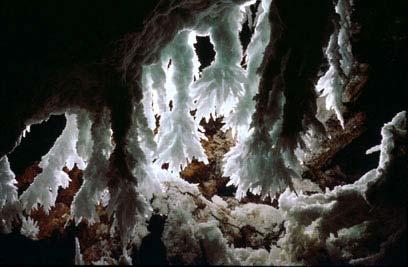
42 Caves and Cave Deposits A cave is a naturally formed subsurface cavity connected to the surface and large enough for a person to enter. A cavern is a very large cave or system of connected caves. Groundwater infiltrating the zone of aeration and flowing in the zone of saturation dissolves carbonate rock to form a system of solution cavities. A drop in the water table drains the previously formed cavities, leaving an interconnected system of caves and cavern. Water seeping into caves forms cave deposits Wicander and Monroe (2002)


43 Cave formation. Chernicoff and Whitney (2002)
44 Cave formations. Chernicoff and Whitney (2002)

45 Caves and Cave deposits As water seeps into caves, CO 2 in the water escapes and a small amount of calcite is precipitated. Almost all cave deposits form in this way and are collectively termed dripstone. Stalactites are icicle-shaped masses suspended from cave ceilings. Stalagmites are spires projecting upward from cave floors. Columns form where stalactites and stalagmites meet. Chernicoff and Whitney (2002)
")
46 Rise and fall of the sea level. Chernicoff and Whitney (2002)
47 Lechuguilla Cave 5 th longest cave in the world (196 km) located in the Carlsbad Caverns, New Mexico Check out Planet Earth (BBC) access only to research and exploration mined in 1914 for Bat Guano (P+N) gypsum, sulfur deposits


48 Lechuguilla


49 Lechuguilla


50 Lechuguilla


51 Lechuguilla

52 Lechuguilla

53 Distribution of karst landforms. Chernicoff and Whitney (2002)
")
54 Landforms & karst topography. Chernicoff and Whitney (2002)

55 Some Cave pictures from Bermuda All pictures are from: vebiology/research/ber muda/

56 Cave Bacon in Bermuda Fort Scaur Cave, Bermuda / Cave bacon-beautiful

57 Bitumen Pitch Cave, Bermuda / Cave entrance

58 Andrew's Cave, Bermuda / Cave entrance

59 Andrew's Cave, Bermuda

60 Blue Hole Hill Cave, Bermuda / Mass of soda straws
Chapter 13. Groundwater
 Chapter 13 Groundwater Introduction Groundwater is all subsurface water that completely fills the pores and other open spaces in rocks, sediments, and soil. Groundwater is responsible for forming beautiful
Prof. Stephen A. Nelson EENS 111. Groundwater
 Page 1 of 8 Prof. Stephen A. Nelson EENS 111 Tulane University Physical Geology This page last updated on 20-Oct-2003 is water that exists in the pore spaces and fractures in rock and sediment beneath
 12 10 8 6 4 2 0 40-50 50-60 60-70 70-80 80-90 90-100 Fresh Water What we will cover The Hydrologic Cycle River systems Floods Groundwater Caves and Karst Topography Hot springs Distribution of water in
Essentials of Geology, 11e
 Essentials of Geology, 11e Groundwater Chapter 10 Instructor Jennifer Barson Spokane Falls Community College Geology 101 Stanley Hatfield Southwestern Illinois Co Jennifer Cole Northeastern University
What is a water table? What is an aquifer? What is the difference between a spring and a well?
 CHAPTER 11 3 Water Underground SECTION The Flow of Fresh Water BEFORE YOU READ After you read this section, you should be able to answer these questions: What is a water table? What is an aquifer? What
Lecture Outlines PowerPoint. Chapter 5 Earth Science 11e Tarbuck/Lutgens
 Lecture Outlines PowerPoint Chapter 5 Earth Science 11e Tarbuck/Lutgens 2006 Pearson Prentice Hall This work is protected by United States copyright laws and is provided solely for the use of instructors
Groundwater. (x 1000 km 3 /y) Reservoirs. Oceans Cover >70% of Surface. Groundwater and the. Hydrologic Cycle
 Reservoirs. Oceans Cover >70% of Surface. Groundwater and the. Hydrologic Cycle") Chapter 13 Oceans Cover >70% of Surface Groundwater and the Hydrologic Cycle Oceans are only 0.025% of Mass Groundwater Groundwater is liquid water that lies in the subsurface in fractures in rocks and
Chapter 13 Oceans Cover >70% of Surface Groundwater and the Hydrologic Cycle Oceans are only 0.025% of Mass Groundwater Groundwater is liquid water that lies in the subsurface in fractures in rocks and
6.1 Water. The Water Cycle
 6.1 Water The Water Cycle Water constantly moves among the oceans, the atmosphere, the solid Earth, and the biosphere. This unending circulation of Earth s water supply is the water cycle. The Water Cycle
Chapter 14. Groundwater
 Chapter 14 Groundwater Importance of groundwater! Groundwater is water found in the pores of soil and sediment, plus narrow fractures in bedrock! Groundwater is the largest reservoir of fresh water that
What we will cover. The Hydrologic Cycle. River systems. Floods. Groundwater. Caves and Karst Topography. Hot springs
 Fresh Water What we will cover The Hydrologic Cycle River systems Floods Groundwater Caves and Karst Topography Hot springs On a piece of paper, put these reservoirs of water in to order from largest to
Groundwater. Earth Chapter 17
 Groundwater Earth Chapter 17 Chapter 17 Groundwater Importance of Groundwater Groundwater is water found in the pores of soil and sediment, plus narrow fractures in bedrock Groundwater and the Hydrosphere
Prentice Hall EARTH SCIENCE
 Prentice Hall EARTH SCIENCE Tarbuck Lutgens Running Water and Groundwater Running Water The Water Cycle Water constantly moves among the oceans, the atmosphere, the solid Earth, and the biosphere. This
Groundwater. (x 1000 km 3 /y) Oceans Cover >70% of Surface. Groundwater and the. Hydrologic Cycle
 Oceans Cover >70% of Surface. Groundwater and the. Hydrologic Cycle") Chapter 17 Oceans Cover >70% of Surface Groundwater and the Hydrologic Cycle Vasey s Paradise, GCNP Oceans are only 0.025% of Mass Groundwater Groundwater is liquid water that lies in the subsurface in
Chapter 17 Oceans Cover >70% of Surface Groundwater and the Hydrologic Cycle Vasey s Paradise, GCNP Oceans are only 0.025% of Mass Groundwater Groundwater is liquid water that lies in the subsurface in
WATER ON AND UNDER GROUND. Objectives. The Hydrologic Cycle
 WATER ON AND UNDER GROUND Objectives Define and describe the hydrologic cycle. Identify the basic characteristics of streams. Define drainage basin. Describe how floods occur and what factors may make
Chapter 14: Groundwater. Fig 14.5b
 Chapter 14: Groundwater Fig 14.5b OBJECTIVES Recognize that groundwater is a vital source of accessible freshwater. Describe how groundwater forms below the water table. Explain the origin of aquifers,
EARTH SCIENCE 11 CHAPTER 9 NOTES WATER MOVING UNDERGROUND
 EARTH SCIENCE 11 CHAPTER 9 NOTES WATER MOVING UNDERGROUND KEY A. ALL THE WORLD S WATER 1. The world has an estimated one and one third thousand million cubic kilometers of water. 2. The earth s water is
STUDY GUIDE FOR CONTENT MASTERY. Movement and Storage of Groundwater
 Groundwater SECTION 10.1 Movement and Storage of Groundwater In your textbook, read about the hydrosphere, precipitation and groundwater, and groundwater storage. Use the following terms to complete the
Groundwater Hydrology
 EXERCISE 12 Groundwater Hydrology INTRODUCTION Groundwater is an important component of the hydrologic cycle. It feeds lakes, rivers, wetlands, and reservoirs; it supplies water for domestic, municipal,
11/22/2010. Groundwater in Unconsolidated Deposits. Alluvial (fluvial) deposits. - consist of gravel, sand, silt and clay
 deposits. - consist of gravel, sand, silt and clay") Groundwater in Unconsolidated Deposits Alluvial (fluvial) deposits - consist of gravel, sand, silt and clay - laid down by physical processes in rivers and flood plains - major sources for water supplies
Groundwater in Unconsolidated Deposits Alluvial (fluvial) deposits - consist of gravel, sand, silt and clay - laid down by physical processes in rivers and flood plains - major sources for water supplies
1 Water Beneath the Surface
 CHAPTER 16 1 Water Beneath the Surface SECTION Groundwater KEY IDEAS As you read this section, keep these questions in mind: What are two properties of aquifers? How is the water table related to the land
Karst found mostly in limestone (rock with at least 50% carbonate minerals), depends on 1) permeability & porosity
, depends on 1) permeability & porosity") KARST LANDFORMS produced by weathering & erosion in regions of carbonate rocks and evaporites processes called karstification mainly below ground surface predominantly underground drainage poorly-developed
KARST LANDFORMS produced by weathering & erosion in regions of carbonate rocks and evaporites processes called karstification mainly below ground surface predominantly underground drainage poorly-developed
10/27/2014. Surface Processes. Surface Processes. Surface Processes. Surface Processes. Surface Processes
 Hewitt/Lyons/Suchocki/Yeh Conceptual Integrated Science Chapter 25 Surface or surficial processes originate at Earth's surface and reshape its contours. Surface processes include: Weathering Erosion Deposition
Surface Processes Focus on Mass Wasting (Chapter 10)
") Surface Processes Focus on Mass Wasting (Chapter 10) 1. What is the distinction between weathering, mass wasting, and erosion? 2. What is the controlling force in mass wasting? What force provides resistance?
Surface Processes Focus on Mass Wasting (Chapter 10) 1. What is the distinction between weathering, mass wasting, and erosion? 2. What is the controlling force in mass wasting? What force provides resistance?
Section I: Multiple Choice Select the best answer to each question. Mark your final answer on the answer sheet. (1 pt each)
") Sedimentary Rocks & Surface Processes Quest Name: Earth Science 2013 Block: Date: Section I: Multiple Choice Select the best answer to each question. Mark your final answer on the answer sheet. (1 pt each)
Sedimentary Rocks & Surface Processes Quest Name: Earth Science 2013 Block: Date: Section I: Multiple Choice Select the best answer to each question. Mark your final answer on the answer sheet. (1 pt each)
RIVERS, GROUNDWATER, AND GLACIERS
 RIVERS, GROUNDWATER, AND GLACIERS Delta A fan-shaped deposit that forms when a river flows into a quiet or large body of water, such as a lake, an ocean, or an inland sea. Alluvial Fan A sloping triangle
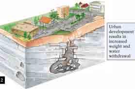
Subsidence is the sinking or collapse of a portion of the land surface. The movement involved in subsidence is essentially vertical; little or no
 1 Subsidence is the sinking or collapse of a portion of the land surface. The movement involved in subsidence is essentially vertical; little or no horizontal motion is involved. It may take the form of
Soils, Hydrogeology, and Aquifer Properties. Philip B. Bedient 2006 Rice University
 Soils, Hydrogeology, and Aquifer Properties Philip B. Bedient 2006 Rice University Charbeneau, 2000. Basin Hydrologic Cycle Global Water Supply Distribution 3% of earth s water is fresh - 97% oceans 1%
C) D) 3. Which graph best represents the relationship between soil particle size and the rate at which water infiltrates permeable soil?
 D) 3. Which graph best represents the relationship between soil particle size and the rate at which water infiltrates permeable soil?") 1. Which earth material covering the surface of a landfill would permit the least amount of rainwater to infiltrate the surface? A) silt B) clay C) sand D) pebbles 2. Which graph best represents the relationship
1. Which earth material covering the surface of a landfill would permit the least amount of rainwater to infiltrate the surface? A) silt B) clay C) sand D) pebbles 2. Which graph best represents the relationship
Florida s Karst Geology
 Florida s Karst Geology Orange Creek Basin Interagency Working Group Public Workshop, November 5 th, 2015 Harley Means, P.G. Assistant State Geologist Florida Geological Survey Karst Karst a type of topography
LBJWC - Sinkhole Lesson
 LBJWC - Sinkhole Lesson Concept Caves and sinkholes are major openings in the ground that recharge water to the Edwards Aquifer. Objective - Students will: 1) identify a sinkhole, cave, fracture, fault,
Land Subsidence. Land subsidence is defined as the lowering of the land surface.
 Land Subsidence Land subsidence is defined as the lowering of the land surface. Many different factors can cause the land surface to subside. Subsidence can occur rapidly due to: a sinkhole or under ground
STUDY GUIDE FOR MID-TERM EXAM KEY. Color, luster, cleavage, fracture, hardness, taste, smell, fluorescence, radioactivity, magnetism
 STUDY GUIDE FOR MID-TERM EXAM KEY 1. In which type of rock are fossils most likely to be found? Sedimentary Rocks 2. Which mineral is easily identified by smell? Sulfur 3. Which natural resource makes
Geology 103 Planet Earth (QR II), Laboratory Exercises 1. Groundwater
, Laboratory Exercises 1. Groundwater") Geology 103 Planet Earth (QR II), Laboratory Exercises 1 Student Name: Section: Karst Landform: Groundwater Anyone who has viewed Chinese landscape scroll paintings will recognize that the mountains are
Geology 103 Planet Earth (QR II), Laboratory Exercises 1 Student Name: Section: Karst Landform: Groundwater Anyone who has viewed Chinese landscape scroll paintings will recognize that the mountains are
Karst Topography In order to understand karst topography we must first have a basic understanding of the water cycle, the formation of limestone (carb
 Karst Topography The formation of caves and other associated features in limestone bedrock is called karst topography. Limestone, a sedimentary rock made mostly of the mineral calcite and small amounts
Which map shows the stream drainage pattern that most likely formed on the surface of this volcano? A) B)
 B)") 1. When snow cover on the land melts, the water will most likely become surface runoff if the land surface is A) frozen B) porous C) grass covered D) unconsolidated gravel Base your answers to questions
1. When snow cover on the land melts, the water will most likely become surface runoff if the land surface is A) frozen B) porous C) grass covered D) unconsolidated gravel Base your answers to questions
Mammoth Cave National Park, Kentucky
 Mammoth Cave National Park, Kentucky Objectives of Today s Lecture Refresher on Sedimentary Depositional Systems and Rock Classifications Transgressive and Regressive Marine Environments Carbonate Depositional
UNIT 4: Earth Science Chapter 21: Earth s Changing Surface (pages )
") CORNELL NOTES Directions: You must create a minimum of 5 questions in this column per page (average). Use these to study your notes and prepare for tests and quizzes. Notes will be turned in to your teacher
CORNELL NOTES Directions: You must create a minimum of 5 questions in this column per page (average). Use these to study your notes and prepare for tests and quizzes. Notes will be turned in to your teacher
Wisconsin s Hydrogeology: an overview
 2012 Soil and Water Conservation Society Conference Stevens Point, WI Feb 9, 2012 Wisconsin s Hydrogeology: an overview Ken Bradbury Wisconsin Geological and Natural History Survey University of Wisconsin-Extension
DATA ACQUISITION METHODS FOR GROUNDWATER INVESTIGATION AND THE SITING OF WATER SUPPLY WELLS
 DATA ACQUISITION METHODS FOR GROUNDWATER INVESTIGATION AND THE SITING OF WATER SUPPLY WELLS M.B.J. Foster Tetra Tech EM Inc., San Francisco, CA, USA Keywords: Groundwater, water wells, drilled wells, geophysical
STUDY GUIDE FOR CONTENT MASTERY. Surface Water Movement
 Surface Water SECTION 9.1 Surface Water Movement In your textbook, read about surface water and the way in which it moves sediment. Complete each statement. 1. An excessive amount of water flowing downslope
HID 362 MESLEKİ İNGİLİZCE 2
 HID 362 MESLEKİ İNGİLİZCE 2 Hafta 5 Prof. Dr. N. Nur ÖZYURT 2017-2018 Bahar Dönemi http://www.philippe-crochet.com/galerie/karst/details/18/lapiaz-et-sites-ruiniformes/236104/rr-14-0032-pic-saint-loupherault-figures-de-karstification-sur-la-crete-ouest
Unit 3 Review - Surface Processes
 Unit 3 Review - Surface Processes 1. Why is the surface of Mercury covered with meteor impact craters, while Earth s surface has relatively few craters? A) Mercury is larger than Earth, so it gets hit
THE CHANGING SURFACE OF THE EARTH
 THE CHANGING SURFACE OF THE EARTH Key words Drain geological agent weathering erosion Sediment deposition transport The landscape is a consequence of the action of two types of geological processes; internal
WEATHERING, EROSION & DEPOSITION STUDY GUIDE
 WEATHERING, EROSION & DEPOSITION STUDY GUIDE Weathering: The difference between mechanical & chemical weathering is: Sort terms as being mechanical/physical or chemical weathering: acid rain, root splitting
Land subsidence due to groundwater withdrawal in Hanoi, Vietnam
 Land Subsidence (Proceedings of the Fifth International Symposium on Land Subsidence, The Hague, October 1995). 1AHS Publ. no. 234, 1995. 55 Land subsidence due to groundwater withdrawal in Hanoi, Vietnam
Geog Lecture 19
 Geog 1000 - Lecture 19 Fluvial Geomorphology and River Systems http://scholar.ulethbridge.ca/chasmer/classes/ Today s Lecture (Pgs 346 355) 1. What is Fluvial Geomorphology? 2. Hydrology and the Water
Lecture 15: Subsidence
 Lecture 15: Subsidence Key Questions 1. How does removal of groundwater cause subsidence on a regional scale? 2. Under what conditions does a building sink into sediment? 3. Why do clays consolidate more
GEOL Introductory Geology: Exploring Planet Earth Fall 2010 Test #2 October 18, 2010
 GEOL 101 - Introductory Geology: Exploring Planet Earth Fall 2010 Test #2 October 18, 2010 Name KEY ID# KEY Multiple choice questions (2 points each). 1. What type of metamorphic rock is formed over large
Hydrogeology of Karst NE Wisconsin. Dr. Maureen A. Muldoon UW-Oshkosh Geology Department
 Hydrogeology of Karst NE Wisconsin Dr. Maureen A. Muldoon UW-Oshkosh Geology Department WI Bedrock Outline Karst Landscapes Existing WQ Data Flow in Karst Aquifers Overview of Silurian Aquifer Water Level
5. Which surface soil type has the slowest permeability rate and is most likely to produce flooding? A) pebbles B) sand C) silt D) clay A) B) C) D)
 pebbles B) sand C) silt D) clay A) B) C) D)") 1. During a heavy rainstorm, soil samples A and B both became saturated with water. However, 10 minutes after the storm ended, the soils appeared as shown below. Which statement best explains the observed
1. During a heavy rainstorm, soil samples A and B both became saturated with water. However, 10 minutes after the storm ended, the soils appeared as shown below. Which statement best explains the observed
Mark S. Nordberg Geology and Groundwater Investigations Section North Central Region Office California Department of Water Resources
 Mark S. Nordberg Geology and Groundwater Investigations Section North Central Region Office California Department of Water Resources Ukiah Drought Workshop July 29, 2009 Groundwater 101 Groundwater is
UGRC 144 Science and Technology in Our Lives/Geohazards
 UGRC 144 Science and Technology in Our Lives/Geohazards Flood and Flood Hazards Dr. Patrick Asamoah Sakyi Department of Earth Science, UG, Legon College of Education School of Continuing and Distance Education
EMERGENCY INVESTIGATION OF EXTREMELY LARGE SINKHOLES, MAOHE, GUANGXI, CHINA
 EMERGENCY INVESTIGATION OF EXTREMELY LARGE SINKHOLES, MAOHE, GUANGXI, CHINA Mingtang Lei, Xiaozhen Jiang, Zhende Guan Institute of Karst Geology, CAGS, Guilin, China, mingtanglei@hotmail.com Yongli Gao
1.72, Groundwater Hydrology Prof. Charles Harvey Lecture Packet #5: Groundwater Flow Patterns. Local Flow System. Intermediate Flow System
 1.72, Groundwater Hydrology Prof. Charles Harvey Lecture Packet #5: Groundwater Flow Patterns c Local Flow System 10,000 feet Intermediate Flow System Regional Flow System 20,000 feet Hydrologic section
Geology 101, Spring 2008
 Geology 101, Spring 2008 Name(s): Lab 10: Groundwater and resource extraction Groundwater As many parts of the world are becoming increasingly aware, groundwater is an economic resource, as strategic and
' International Institute for Land Reclamation and Improvement. 2 Groundwater Investigations. N.A. de Ridder'? 2.1 Introduction. 2.
 2 Groundwater Investigations N.A. de Ridder'? 2.1 Introduction Successful drainage depends largely on a proper diagnosis of the causes of the excess water. For this diagnosis, one must consider: climate,
Chapter 6 Running Water and Groundwater
 Chapter 6 Running Water and Groundwater Section 1 Running Water Key Concepts What is the water cycle? What does it mean to say Earth s water cycle is balanced? What is the most important factor in determining
Glaciers. 1. The photograph below shows the results of a landslide.
 Name: Date: 1. The photograph below shows the results of a landslide. This landslide is an example of A) wind abrasion B) glacial deposition C) wave action D) mass movement 2. Which agent of erosion is
UNIT 12: THE HYDROLOGIC CYCLE
 UNIT 12: THE HYDROLOGIC CYCLE After Unit 12 you should be able to: o Effectively use the charts Average Chemical Composition of Earth s Crust, Hydrosphere and Troposphere, Selected Properties of Earth
River Processes. Drainage Basin Morphometry
 Drainage Basin Morphometry River Processes Morphometry - the measurement and mathematical analysis of the configuration of the earth s surface and of the shape and dimensions of its landforms. Horton (1945)
Chapter 8 Fetter, Applied Hydrology 4 th Edition, Geology of Groundwater Occurrence
 Chapter 8 Fetter, Applied Hydrology 4 th Edition, 2001 Geology of Groundwater Occurrence Figure 8.42. Alluvial Valleys ground-water region. Fetter, Applied Hydrology 4 th Edition, 2001 Fetter, Applied
Groundwater Quality. Landform Development by Subsurface Water. Karst Landscapes and Landforms
 LANDFORM DEVELOPMENT BY SUBSURFACE WATER 447 320 kilometers (200 mi) away (see again Fig. 16.8). Other wellknown artesian systems are found in Olympia, Washington; the western Sahara; and eastern Australia
Weathering Notes. When the mineral composition of the rock is changed
 Weathering Notes Weathering Weathering is the breaking down on rocks into smaller pieces Two types of weathering o Physical (mechanical) When the mineral composition of the rock isn t changed Ex: Smashing
Groundwater. Chapter Outline. Chapter. Surface. Chemical Weathering. Why It Matters. 1 Water Beneath the. 2 Groundwater and
 16 Chapter Groundwater Chapter Outline 1 Water Beneath the Surface Properties of Aquifers Zones of Aquifers Movement of Groundwater Topography and the Water Table Conserving Groundwater Wells and Springs
Miami-Dade College. The student will demonstrate a basic knowledge of the origin and evolution of the Earth and its planetary environment.
 Miami-Dade College Common Course Number: GLY 3884 Course Title: Environmental Geology Catalog Course Description: This course focuses on the study of the application of geology to the interactions between
GROUNDWATER MEGA PACKET
 NAME GROUNDWATER MEGA PACKET 1. The diagram below shows columns A, B, C, and D that contain different sediments. Equal volumes of water were poured through each column. Which column of sediment retained
Lab 9: Petroleum and groundwater
 Geology 101 Name(s): Lab 9: Petroleum and groundwater Petroleum (oil) is a multi-component liquid refined to generate different hydrocarbons, such as heptane (a component of gasoline) and waxes. For the
Reservoirs and Production
 Lesson Plan - Page 1 Topic Reservoirs and Production Source Oil and Natural Gas, pages 24-25, 26-27 Objective The students will learn that porosity refers to the percentage of holes (pores) in the rock.
Topic 6: Weathering, Erosion and Erosional-Deposition Systems (workbook p ) Workbook Chapter 4, 5 WEATHERING
 Workbook Chapter 4, 5 WEATHERING") Topic 6: Weathering, Erosion and Erosional-Deposition Systems (workbook p. 95-125) Workbook Chapter 4, 5 THE BIG PICTURE: Weathering, erosion and deposition are processes that cause changes to rock material
Topic 6: Weathering, Erosion and Erosional-Deposition Systems (workbook p. 95-125) Workbook Chapter 4, 5 THE BIG PICTURE: Weathering, erosion and deposition are processes that cause changes to rock material
Surface Water and Stream Development
 Surface Water and Stream Development Surface Water The moment a raindrop falls to earth it begins its return to the sea. Once water reaches Earth s surface it may evaporate back into the atmosphere, soak
Connecticut's Aquifers
 Page 1 of 5 DEP Search: Connecticut's Aquifers The technical definition of the word "aquifer" is: any geologic formation capable of yielding significant quantities of water to wells. By that definition,
HW #2 Landscape Travel from A to B 12,
 HW #2 Landscape 2016 Section: Name: ate: 1. ase your answer(s) to the following question(s) on the map below, which represents two bridges that cross the Green River. Letters,, and represent locations
3/15/17. #22 - Subsidence - Rapid Sinkhole at Winter Park, FL in Rapid Subsidence Defined and Illustrated
 Web Exercise #3 (Volcanoes) Late- closing at 1:00 today Web Exercise #4 (Landslides) DUE WEDNESDAY Use Hazard City to answer matching question in Part II #22 - Subsidence - Rapid Sinkhole at Winter Park,
Name: KEY OBJECTIVES HYDROLOGY:
 Name: KEY OBJECTIVES Correctly define: abrasion, capillarity, deposition, discharge, erosion, evapotranspiration, hydrology, impermeable, infiltration, meander, permeable, porosity, water table, weathering,
Unit 4: Landscapes Practice Problems
 Name: Date: 1. Soil with the greatest porosity has particles that are A. poorly sorted and densely packed B. poorly sorted and loosely packed C. well sorted and densely packed D. well sorted and loosely
8UNIT. External dynamics of the Earth. What do you remember? Key language. Content objectives
 8UNIT External dynamics of the Earth What do you remember? Can you name the solids in the photograph? nd the liquid? Is the liquid moving? How does it move? What is the name of this formation of water?
Name. 4. The diagram below shows a soil profile formed in an area of granite bedrock. Four different soil horizons, A, B, C, and D, are shown.
 Name 1. In the cross section of the hill shown below, which rock units are probably most resistant to weathering? 4. The diagram below shows a soil profile formed in an area of granite bedrock. Four different
GEOL 110. Sedimentary Layering. Geologic Structures (faults, joints, folds), Unconformities, Karst. Sedimentary Layering 9/23/17. Geologic Structures
, Unconformities, Karst. Sedimentary Layering 9/23/17. Geologic Structures") GEOL 110 Sedimentary Layering Geologic Structures (faults, joints, folds), Unconformities, Karst Layering = horizontal, continuous banding produced during sediment deposition Sedimentary Layering Geologic
GEOL 110 Sedimentary Layering Geologic Structures (faults, joints, folds), Unconformities, Karst Layering = horizontal, continuous banding produced during sediment deposition Sedimentary Layering Geologic
Exam #3 Study Guide Questions
 Exam #3 Study Guide Questions Below are questions that go with the notes we discussed in class. You do not need to answer these questions, as they will not be collected. These are intended to help you
The Earth s Layers. Convection and Hot Spots. The Earth s Layers. The Earth s resources were determined when the planet formed.
 The Earth s resources were determined when the planet formed. Chapter 8 Earth Systems and Resources The Earth s Layers Core- the innermost zone of the planet made of nickel and iron. Mantle- above the
Chapter 3 Erosion and Deposition. The Big Question:
 Chapter 3 Erosion and Deposition The Big Question: 1 Design a way to represent and describe the 4 types of mass movement. You may use pictures, diagrams, list, web, chart, etc 2 Chapter 3: Erosion and
Ground-Water Flow through Porous Medium. GEO 321 Lecture 14 Dr. J. S. Kite. Groundwater, Karst, and Caves
 GEO 321 Lecture 14 Dr. J. S. Kite The Rock Organ Organ Cave, Greenbrier Co., WV Groundwater, Karst, and Caves Soil & Ground Water Distribution Eastern USA Soil Moisture Belt Unsaturated (Aeration) Zone
Karst Landforms. Caverns Sinkholes Disappearing Streams Springs Towers
 Karst Landforms Karst is a term used to describe landscapes that are formed by chemical weathering process controlled by groundwater activity. Karst landscapes are predominantly composed of limestone rock
Solution Processes and. Karst Topography
 Solution Processes & Karst Topography Come forth into the light of things, Let Nature be your teacher. William Wordsworth 1 Solution Processes and Karst Topography The Impact of Solution Processes on the
Freshwater. 1. The diagram below is a cross-sectional view of rain falling on a farm field and then moving to the water table.
 Name: ate: 1. The diagram below is a cross-sectional view of rain falling on a farm field and then moving to the water table. 3. Which conditions produce the most surface water runoff? A. steep slope,
Chapter 13 Unsafe Ground: Landslides and Other Mass Movements
 Chapter 13 Unsafe Ground: Landslides and Other Mass Movements What is the controlling force for mass wasting? What factors influence mass wasting? Classification of Mass Wasting Mass wasting events are
1. Base your answer to the following question on The diagram below represents a part of the crystal structure of the mineral kaolinite.
 1. Base your answer to the following question on The diagram below represents a part of the crystal structure of the mineral kaolinite. An arrangement of atoms such as the one shown in the diagram determines
KARST LANDSCAPES Geology & Hydrology. Dr. Gerald E. Weber
 KARST LANDSCAPES Geology & Hydrology Dr. Gerald E. Weber Aerial Oblique Photograph of the UCSC Campus looking northwest Karst A type of topography that is formed on limestone, gypsum, and other soluble
Erosion Surface Water. moving, transporting, and depositing sediment.
 + Erosion Surface Water moving, transporting, and depositing sediment. + Surface Water 2 Water from rainfall can hit Earth s surface and do a number of things: Slowly soak into the ground: Infiltration
Laboratory Exercise #4 Geologic Surface Processes in Dry Lands
 Page - 1 Laboratory Exercise #4 Geologic Surface Processes in Dry Lands Section A Overview of Lands with Dry Climates The definition of a dry climate is tied to an understanding of the hydrologic cycle
URBAN HYDROLOGY: WATER IN THE CITY OF TSHWANE Plant Sciences Auditorium, University of Pretoria January 2014 URBAN HYDROGEOLOGY
 URBAN HYDROLOGY: WATER IN THE CITY OF TSHWANE Plant Sciences Auditorium, University of Pretoria 23 24 January 2014 URBAN HYDROGEOLOGY MATTHYS A. DIPPENAAR DEPARTMENT GEOLOGY, UNIVERSITY OF PRETORIA HYDROGEOLOGY
Dr. N.W. B. Balasooriya
 ESM 31031 HYDROGEOLOGY Dr. N.W. B. Balasooriya 1 1 Hydrogeology Hydrogeology is defined as the science which treats the occurrence, distribution and movement of water below the Earth surface. 2 Groundwater
Water Erosion (pages )
") Water Erosion (pages 272 281) Runoff and Erosion (pages 273 274) Key Concept: Moving water is the major agent of the erosion that has shaped Earth s land surface. Falling raindrops can loosen and pick
Water Erosion (pages 272 281) Runoff and Erosion (pages 273 274) Key Concept: Moving water is the major agent of the erosion that has shaped Earth s land surface. Falling raindrops can loosen and pick
1. The map below shows a meandering river. A A' is the location of a cross section. The arrows show the direction of the river flow.
 1. The map below shows a meandering river. A A' is the location of a cross section. The arrows show the direction of the river flow. Which cross section best represents the shape of the river bottom at
Earth: The Water Planet
 Earth: The Water Planet Water is essential for living things to grow, reproduce, and carry out important processes. About 97% of Earth s water is salt water found in the ocean, while the other 3% is fresh
Weathering, Mass Wasting and Karst
 Weathering, Mass Wasting and Karst Capable of wearing down anything that the internal processes can build. Gravity, water, wind and ice Denudation - the overall effect of disintegration, wearing away and
Erosion and Deposition
 Erosion and Deposition Erosion Sediment natural forces move rock/soil from one place to another. gravity, water, wind, glaciers, waves are causes material moved by erosion Deposition when erosion lays
Page 1. Weathering & Erosion by Mass Wasting Pre-Test. Name:
 Weathering & Erosion by Mass Wasting Pre-Test 3048-1 - Page 1 Name: 1) As a particle of sediment in a stream breaks into several smaller pieces, the rate of weathering of the sediment will A) increase
Pratice Surface Processes Test
 1. The cross section below shows the movement of wind-driven sand particles that strike a partly exposed basalt cobble located at the surface of a windy desert. Which cross section best represents the
Chapter 6 Sedimentary and Metamorphic Rock
 Chapter 6 Sedimentary and Metamorphic Rock Weathering and Erosion Wherever rock is exposed at Earth s surface, it is continuously being broken down by weathering a set of physical and chemical processes