KARST LANDSCAPES Geology & Hydrology. Dr. Gerald E. Weber
|
|
|
- Bryan Hart
- 5 years ago
- Views:
Transcription
1
2 KARST LANDSCAPES Geology & Hydrology Dr. Gerald E. Weber

3 Aerial Oblique Photograph of the UCSC Campus looking northwest
4 Karst A type of topography that is formed on limestone, gypsum, and other soluble rocks by solution, and that is characterized by sinkholes, caves, and underground drainage. There is no integrated surface drainage system. It is not a fluvial (stream formed) landscape. Doline A sinkhole or closed depression in which surface runoff collects and percolates into the underground drainage system. Swallow Hole a closed depression or doline into which all or part of a stream disappears underground. Limestone a rock composed of calcium carbonate (CaCO 3 ) that is soluble in carbonic acid. Marble a limestone that has been metamorphosed - essentially cooked by high temperatures resulting in recrystallization of the original rock. It s still CaCO 3 but the original texture has been destroyed.


5 Intergranular porosity 0 10 mm Two Major Types of Porosity Map of Fracture porosity

6 Chemical Weathering of Limestone Limestone CaCO 3 Is dissolved by carbonic Acid: H 2 CO 3 CaCO 3 + H 2 CO 3 = Ca 2+ and 2(HCO 3 ) 1- The carbonic acid is formed in the atmosphere during rainfall as carbon dioxide goes into solution: H 2 O + CO 2 = H 2 CO 3 = H 1+ HCO 3 1- Photo: An example of pavement karst. All soil has been stripped from the underlying bedrock surface revealing the solution weathering along preexisting fractures.

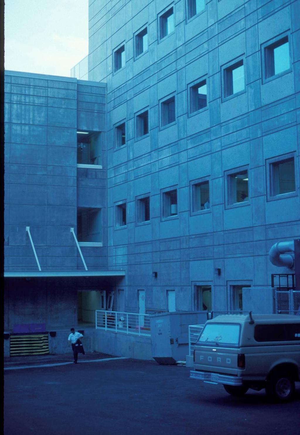
7 Steep walled doline in front of the Engineering building UCSC Campus.

8 Spring locations and monitoring sites to determine flow volumes for the subterranean streams that drain the campus. It is a complex and rather poorly understood system. The round dots are springs. The lines below the springs are the streams fed by the springs. The T at the end of the streams are the flow termini the stream goes underground. Note that almost all of the streams reenter the subsurface at some point. Bay Street Spring


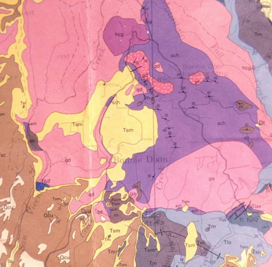
9 Karst Landscape in Santa Cruz County Limestone dark purple Limestone dark brown UCSC Davenport - Bonny Doon
 limestone The mineral is calcite Calcium carbonate = CaCO 3 Soluble in")
10 Regional Geologic Map UCSC Tan recent alluvium Yellow - terraces Orange sedimentary rocks Red - granite Light purple schist Dark purple marble Marble = recrystallized (cooked) limestone The mineral is calcite Calcium carbonate = CaCO 3 Soluble in acids

11 North South cross sections across the UCSC campus Note that the marble (blue) is a small sliver of marble that has been down dropped along faults into the hard non-soluble granitic basement rock.
12

13 East field house Remote parking Jordan Gulch Chancellor Gulch Aerial oblique view of the UCSC campus looking northeast. Note the two thoroughgoing streams Jordan and Chancellor Gulch. They have no true tributaries and flow only during the largest storms and only for a short time. The vast majority of the water that falls on campus goes straight down into the solution cavities.


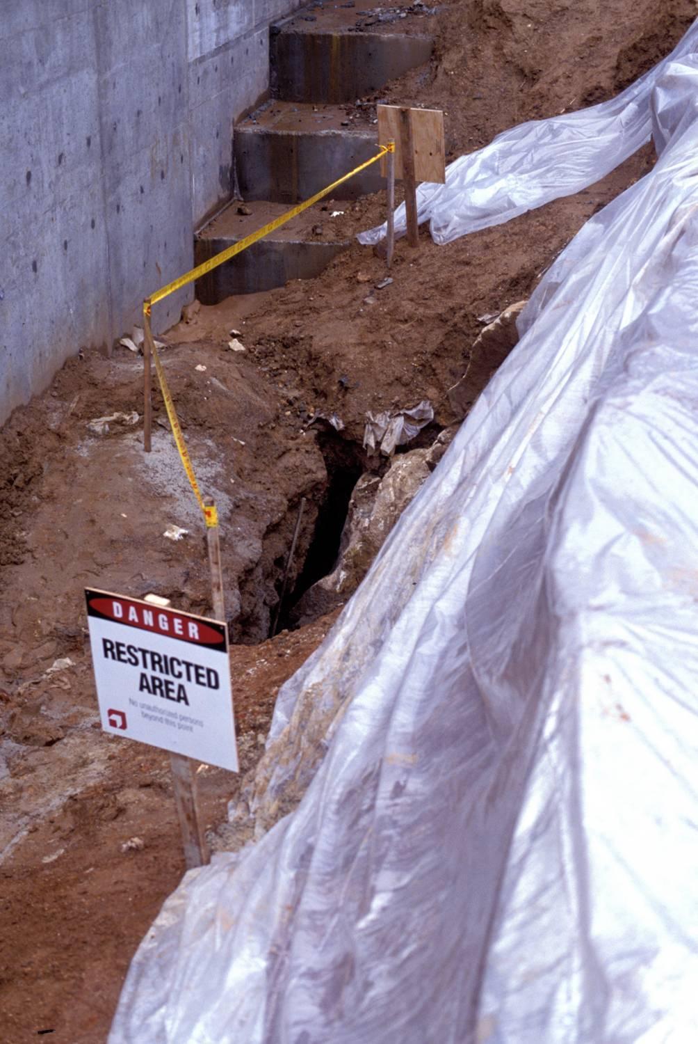
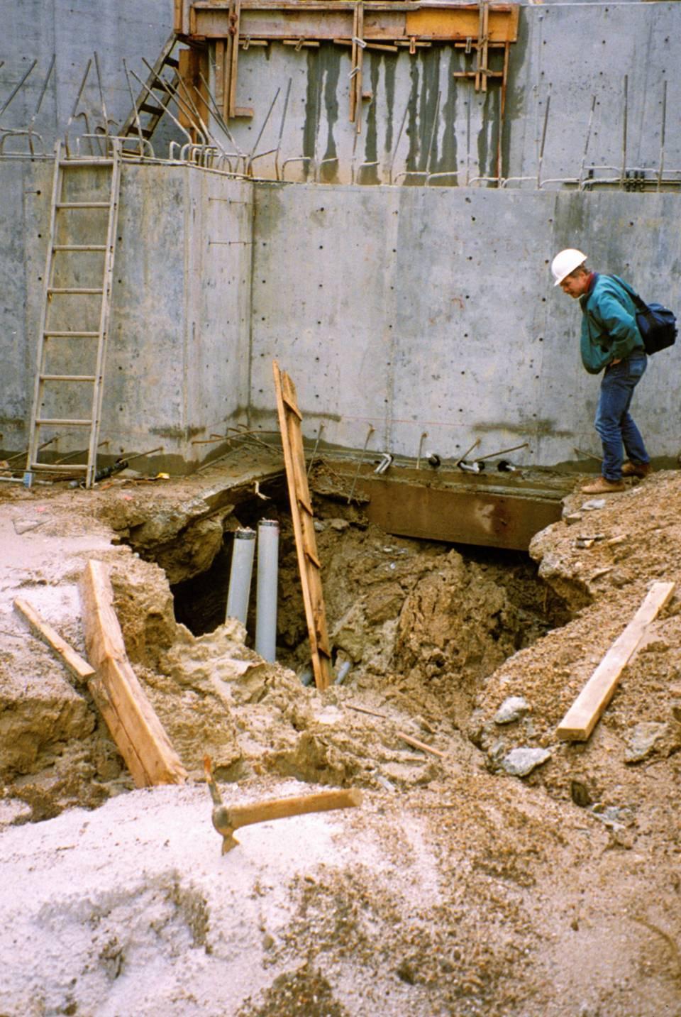
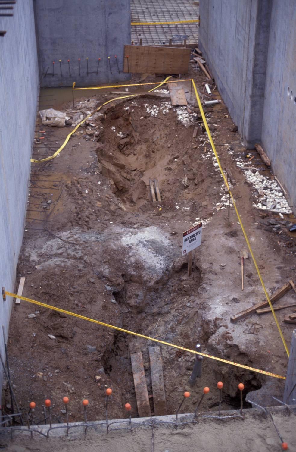
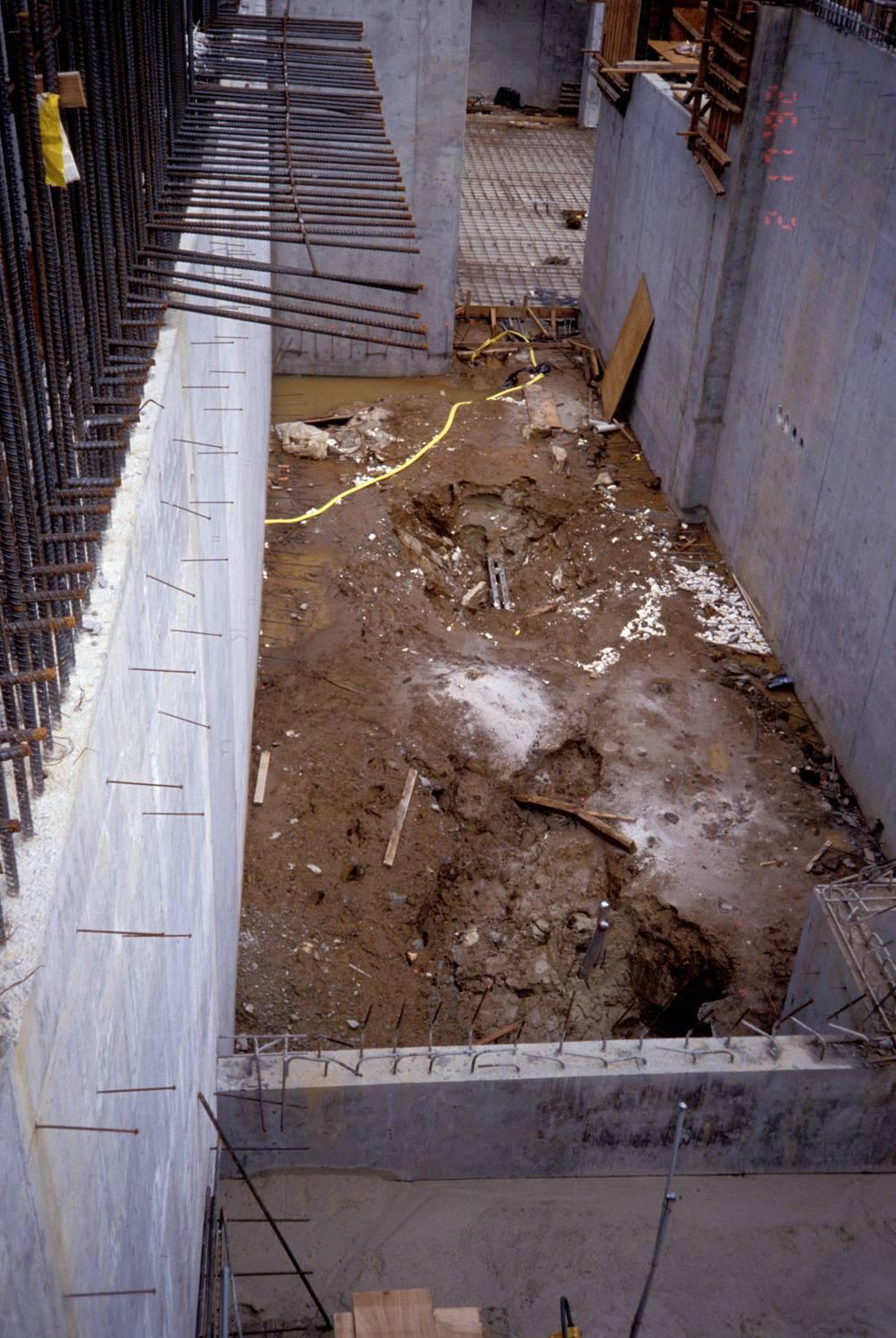
14 The thin red arrow points to the location of the sinkhole


15 Examples of doline and cavern formation all occur as a result of an underground void that increases in size till the overlying ground eventually collapses into the void.
16 Geologic Problems Associated With Karst 1. Doline Formation ground failure or collapse. May be triggered by: a. Construction grading, excavation, overloading b. Changes to surface water and/or ground water flow. c. Acts of God 2. Changes to Ground Water System a. Contamination b. Changes in flow volume and direction

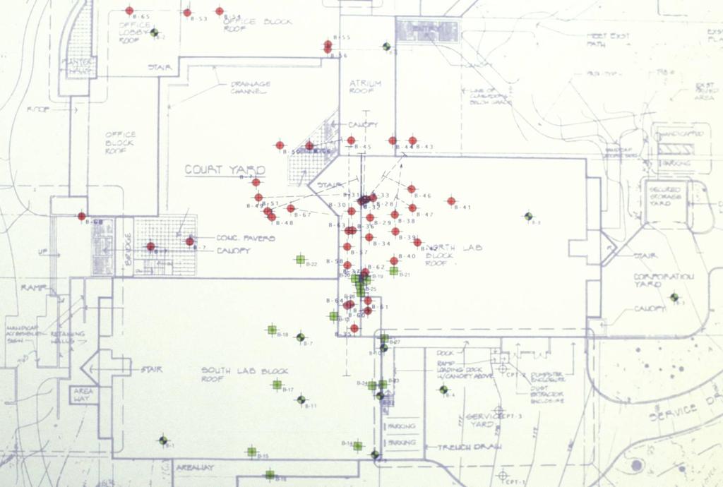
17 Map of the East Sports Complex The original site for the east complex swimming pool was directly on top of a collapse doline. At that site there was the probability of additional collapse in the future that would have been hard to mitigate during construction. It was moved to an area where there were only two small solution channels in a doline formed in an area with a high density of fractures not a collapse. Note that 72 exploratory borings were drilled in the pool footprint. This allowed an accurate understanding of the under-lying geology and the development of an adequate foundation.
 Note East Field House & pool blue = marble green = schist yellow =")
18 Earth & Marine Sciences Bldg Red area are sediment filled sinkholes (dolines) Note East Field House & pool blue = marble green = schist yellow = sandstone
19
20
21
22
23 NORTH


24 E&MS building site Light purple - schist Dark purple - limestone
25 Spring locations for the subterranean streams that drain the campus. It is a complex and rather poorly understood system. The round dots are springs. The lines below the springs are the streams fed by the springs. The T at the end of the streams are the flow termini the stream goes underground. The red arrow points to the E&MS building site. Bay Street Spring

26 Interpretive map of the Major fracture systems, and therefore subterranean passages, along which water flows under the campus. There are Also numerous smaller fractures and solution passages between these major passages. So what does this look like underground??
27 What would the UCSC campus (or Bonny Doon ) look like if we could see a full cross section through the karst areas?? This can be imagined by viewing an active karst terrain exposed in the walls of Marble Canyon the northerly portion of the Grand Canyon. Go to next slide for an interpretation. Colorado River

28 What would the campus look like if we could see a full cross section through the campus?? This can be imagined by viewing an active karst terrain exposed in the walls of Marble Canyon the northerly portion of the Grand Canyon. The yellow arrows point to obvious voids along which water moves in the sub surface. The red arrows point out the major fracture systems along which the voids formed. Note that the large voids do not occur everywhere along a single fracture.

29 Karst solution channels along fractures in the Redwall Limestone in the Grand Canyon


30 Marble Canyon Thunder Spring tributary to Tapeats Creek

31 3 1 2 Development of a karst system over time. The UCSC campus is at about the stage of #3. Note the through going stream. San Lorenzo River As it cuts down it provides the base level to which the underground flow can reach. The deeper the river cuts down the deeper the cavern system grows. In respect to the UCSC campus the San Lorenzo river is the equivalent of the stream in this diagram. 4 The Role of the San Lorenzo River in the formation of the UCSC karst terrain

32 Something completely different Namib Dune Field

33 To dowse or not to dowse that is the question? A TALE OF TWO WELLS or Phenomenology Fails Again

34 Excellent location Poor location no fracture no water, or very little How to site a well in karst terrain. Drill into a fracture trace preferably at the intersection of two major fractures.

35 There are numerous potential sites for water wells on the campus as indicated by yellow dots (not all potential sites are shown). Almost any fracture intersection will do. The three red dots are along the largest and best developed fracture system on campus. It also lies at the southern edge of the campus which is down hill from the rest of campus. Therefore it is where most of the water that percolates through the campus will end up. Two of the locations are at intersections, while the other is at the edge of the largest collapse doline on campus. The red arrow is the location where we drilled a well which produced water at a hundred gallons per minute for a full week (1 million gallons produced) with no appreciable drawdown of the water table.
36 Well located at intersection of two fractures as shown on last slide. Drilled in 1989 to a depth of 220 feet, with the water table at 100 feet. Produced at 100 gallons per minute during a week long pump test resulted in a 2.5 foot draw down. Capable of producing gallons per minute, or more. Well site located by two different dowsers on separate days. Drilled to a depth of 300 feet in A non productive site. They were only able to produce 2-3 gallons per minute.

37 Well located at intersection of two fractures as shown on last slide. Drilled in 1989 to a depth of 220 feet with the water table at 100 feet. Produced over 100 gallons per minute and was capable of gallons per minute. Blue lines indicate fractures. Well site located by two different dowsers on separate days. Drilled to a depth of 300 feet in A non productive site. They were only able to produce 2-3 gallons per minute.

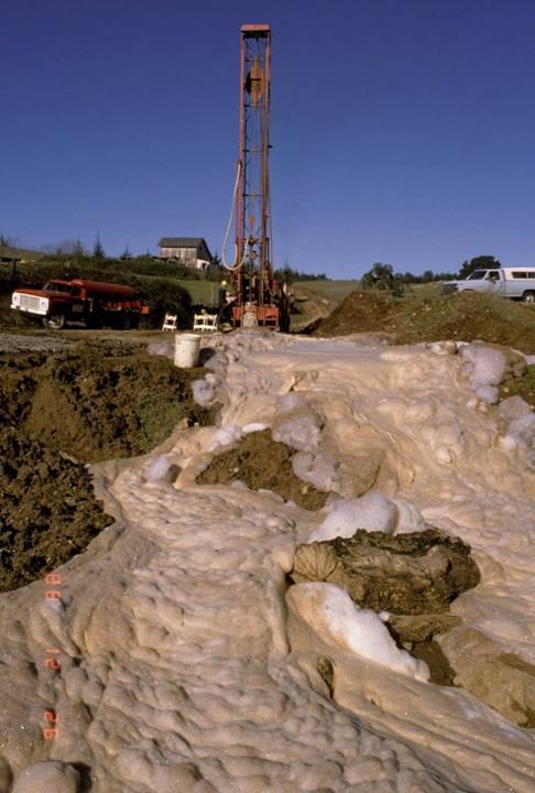
38 Drilling the well
39 Vulnerability of Karst to Contamination Once contaminants in surface waters get into the water in the void system in the limestone there is no filtering effect. Other sedimentary rock types (sands and silts) provide a filtering effect as the water slowly moves through the small pore spaces and come into contact with a variety of minerals including clays. Consequently, contaminated water cannot be allowed to enter the karst system because it will not be filtered without percolation through soils and sediments. Requirements in respect to the disposal of contaminated water that are acceptable for most types of terrains are in most instances not applicable to karst. This includes the horizontal distance to streams or other bodies of water. The thickness of sediments overlying the karst, and the composition of those sediments are the most important considerations. The sediments must be of the proper composition and thickness to be able to filter out all of the contaminants from the surface waters prior to their reaching the karst system. The biggest problem in dealing with contaminants in karst terrain is trying to determine the thicknesses of these sediments combined with the shape of the underlying limestone mass. These are exceedingly difficult to determine from surface exposures alone. Consequently, extensive subsurface studies need to be prepared for each site. ( continued - next slide)

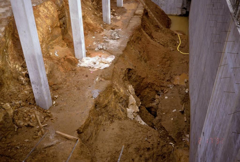
40 Vulnerability of Karst to Contamination 5. Types of sub-surface studies include (but not limited to): 1. wells and borings, 2. exploratory trenches, 3. geophysical techniques. Without such studies it is impossible to know what lies beneath the soil. The contact between the overlying sediments that cover the limestone can be exceedingly complex. The photo below and the next two slides are examples of the complexity of the limestone surface where the overlying sediment has been removed by erosion. The complexity of the bedrock surface makes it impossible to really ever know what lies beneath the overlying sediments.

41

42 Karst terrain on the island of Niue near Tonga in the southwest Pacific.

43
44
45 Food for thought from: When the Rivers Run Dry by Fred Pearce 1. It takes between 250 and 650 gallons of water to grow a pound of rice. 2. It takes about 65 gallons to grow a pound of potatoes. 3. It takes 3000 gallons of water to grow the feed for enough cow to make a quarter pound hamburger. 4. A one pound jar of coffee requires 2650 pounds of water. 5. A glass of milk - 65 gallons. 6. A small steak 1320 gallons.
46 This brief presentation should be considered an introduction to limestone karst terrains, their hydrologic systems, their unique topography, and their susceptibility to contamination. If you wish to expand your understanding of these terrains I suggest searching the internet. The USGS website and numerous others go into far greater detail than I have. An excellent publication is Living with Karst A fragile foundation by the American Geological Institute. For the geology of the UCSC Campus I suggest the recently published The Natural History of the UC Santa Cruz Campus edited by Haff, Brown and Tyler. The second chapter covers the campus geology and the limestone karst. With the book in hand you should also take some time to visit the campus and examine some of the features that are described there and discussed here.

47 Two methods of doline formation based only on fracture density. There has been no collapse or formation of a large void underground.

48 Doline (sinkhole) Formation Dolines are formed in areas where there is sufficient solution of limestone at depth to generate subsidence of the overlying soils or sediments.


49 Limestone karst in Marble Canyon on the Colorado River
50 Doline formed by the collapse of the roof of a cavern forming an entrance to the underground system.
51 Dolines formed along fractures near the bike path
52 Chancellor Gulch Jordan Gulch
Groundwater. (x 1000 km 3 /y) Oceans Cover >70% of Surface. Groundwater and the. Hydrologic Cycle
 Oceans Cover >70% of Surface. Groundwater and the. Hydrologic Cycle") Chapter 17 Oceans Cover >70% of Surface Groundwater and the Hydrologic Cycle Vasey s Paradise, GCNP Oceans are only 0.025% of Mass Groundwater Groundwater is liquid water that lies in the subsurface in
Chapter 17 Oceans Cover >70% of Surface Groundwater and the Hydrologic Cycle Vasey s Paradise, GCNP Oceans are only 0.025% of Mass Groundwater Groundwater is liquid water that lies in the subsurface in
Land Subsidence. Land subsidence is defined as the lowering of the land surface.
 Land Subsidence Land subsidence is defined as the lowering of the land surface. Many different factors can cause the land surface to subside. Subsidence can occur rapidly due to: a sinkhole or under ground
6.1 Water. The Water Cycle
 6.1 Water The Water Cycle Water constantly moves among the oceans, the atmosphere, the solid Earth, and the biosphere. This unending circulation of Earth s water supply is the water cycle. The Water Cycle
Prentice Hall EARTH SCIENCE
 Prentice Hall EARTH SCIENCE Tarbuck Lutgens Running Water and Groundwater Running Water The Water Cycle Water constantly moves among the oceans, the atmosphere, the solid Earth, and the biosphere. This
Groundwater. (x 1000 km 3 /y) Reservoirs. Oceans Cover >70% of Surface. Groundwater and the. Hydrologic Cycle
 Reservoirs. Oceans Cover >70% of Surface. Groundwater and the. Hydrologic Cycle") Chapter 13 Oceans Cover >70% of Surface Groundwater and the Hydrologic Cycle Oceans are only 0.025% of Mass Groundwater Groundwater is liquid water that lies in the subsurface in fractures in rocks and
Chapter 13 Oceans Cover >70% of Surface Groundwater and the Hydrologic Cycle Oceans are only 0.025% of Mass Groundwater Groundwater is liquid water that lies in the subsurface in fractures in rocks and
Subsidence is the sinking or collapse of a portion of the land surface. The movement involved in subsidence is essentially vertical; little or no
 1 Subsidence is the sinking or collapse of a portion of the land surface. The movement involved in subsidence is essentially vertical; little or no horizontal motion is involved. It may take the form of
Prof. Stephen A. Nelson EENS 111. Groundwater
 Page 1 of 8 Prof. Stephen A. Nelson EENS 111 Tulane University Physical Geology This page last updated on 20-Oct-2003 is water that exists in the pore spaces and fractures in rock and sediment beneath
3/15/17. #22 - Subsidence - Rapid Sinkhole at Winter Park, FL in Rapid Subsidence Defined and Illustrated
 Web Exercise #3 (Volcanoes) Late- closing at 1:00 today Web Exercise #4 (Landslides) DUE WEDNESDAY Use Hazard City to answer matching question in Part II #22 - Subsidence - Rapid Sinkhole at Winter Park,
WATER ON AND UNDER GROUND. Objectives. The Hydrologic Cycle
 WATER ON AND UNDER GROUND Objectives Define and describe the hydrologic cycle. Identify the basic characteristics of streams. Define drainage basin. Describe how floods occur and what factors may make
STUDY GUIDE FOR CONTENT MASTERY. Surface Water Movement
 Surface Water SECTION 9.1 Surface Water Movement In your textbook, read about surface water and the way in which it moves sediment. Complete each statement. 1. An excessive amount of water flowing downslope
Essentials of Geology, 11e
 Essentials of Geology, 11e Groundwater Chapter 10 Instructor Jennifer Barson Spokane Falls Community College Geology 101 Stanley Hatfield Southwestern Illinois Co Jennifer Cole Northeastern University
Florida s Karst Geology
 Florida s Karst Geology Orange Creek Basin Interagency Working Group Public Workshop, November 5 th, 2015 Harley Means, P.G. Assistant State Geologist Florida Geological Survey Karst Karst a type of topography
HID 362 MESLEKİ İNGİLİZCE 2
 HID 362 MESLEKİ İNGİLİZCE 2 Hafta 5 Prof. Dr. N. Nur ÖZYURT 2017-2018 Bahar Dönemi http://www.philippe-crochet.com/galerie/karst/details/18/lapiaz-et-sites-ruiniformes/236104/rr-14-0032-pic-saint-loupherault-figures-de-karstification-sur-la-crete-ouest
Karst Topography In order to understand karst topography we must first have a basic understanding of the water cycle, the formation of limestone (carb
 Karst Topography The formation of caves and other associated features in limestone bedrock is called karst topography. Limestone, a sedimentary rock made mostly of the mineral calcite and small amounts
 12 10 8 6 4 2 0 40-50 50-60 60-70 70-80 80-90 90-100 Fresh Water What we will cover The Hydrologic Cycle River systems Floods Groundwater Caves and Karst Topography Hot springs Distribution of water in
LBJWC - Sinkhole Lesson
 LBJWC - Sinkhole Lesson Concept Caves and sinkholes are major openings in the ground that recharge water to the Edwards Aquifer. Objective - Students will: 1) identify a sinkhole, cave, fracture, fault,
Lecture 15: Subsidence
 Lecture 15: Subsidence Key Questions 1. How does removal of groundwater cause subsidence on a regional scale? 2. Under what conditions does a building sink into sediment? 3. Why do clays consolidate more
Karst found mostly in limestone (rock with at least 50% carbonate minerals), depends on 1) permeability & porosity
, depends on 1) permeability & porosity") KARST LANDFORMS produced by weathering & erosion in regions of carbonate rocks and evaporites processes called karstification mainly below ground surface predominantly underground drainage poorly-developed
KARST LANDFORMS produced by weathering & erosion in regions of carbonate rocks and evaporites processes called karstification mainly below ground surface predominantly underground drainage poorly-developed
Chapter 13. Groundwater
 Chapter 13 Groundwater Introduction Groundwater is all subsurface water that completely fills the pores and other open spaces in rocks, sediments, and soil. Groundwater is responsible for forming beautiful
11/22/2010. Groundwater in Unconsolidated Deposits. Alluvial (fluvial) deposits. - consist of gravel, sand, silt and clay
 deposits. - consist of gravel, sand, silt and clay") Groundwater in Unconsolidated Deposits Alluvial (fluvial) deposits - consist of gravel, sand, silt and clay - laid down by physical processes in rivers and flood plains - major sources for water supplies
Groundwater in Unconsolidated Deposits Alluvial (fluvial) deposits - consist of gravel, sand, silt and clay - laid down by physical processes in rivers and flood plains - major sources for water supplies
Chapter 14. Groundwater
 Chapter 14 Groundwater Importance of groundwater! Groundwater is water found in the pores of soil and sediment, plus narrow fractures in bedrock! Groundwater is the largest reservoir of fresh water that
10/27/2014. Surface Processes. Surface Processes. Surface Processes. Surface Processes. Surface Processes
 Hewitt/Lyons/Suchocki/Yeh Conceptual Integrated Science Chapter 25 Surface or surficial processes originate at Earth's surface and reshape its contours. Surface processes include: Weathering Erosion Deposition
Solution Processes and. Karst Topography
 Solution Processes & Karst Topography Come forth into the light of things, Let Nature be your teacher. William Wordsworth 1 Solution Processes and Karst Topography The Impact of Solution Processes on the
Groundwater. Earth Chapter 17
 Groundwater Earth Chapter 17 Chapter 17 Groundwater Importance of Groundwater Groundwater is water found in the pores of soil and sediment, plus narrow fractures in bedrock Groundwater and the Hydrosphere
STUDY GUIDE FOR CONTENT MASTERY. Movement and Storage of Groundwater
 Groundwater SECTION 10.1 Movement and Storage of Groundwater In your textbook, read about the hydrosphere, precipitation and groundwater, and groundwater storage. Use the following terms to complete the
KARST MAPPING WITH GEOPHYSICS AT MYSTERY CAVE STATE PARK, MINNESOTA
 KARST MAPPING WITH GEOPHYSICS AT MYSTERY CAVE STATE PARK, MINNESOTA By Todd A. Petersen and James A. Berg Geophysics Program Ground Water and Climatology Section DNR Waters June 2001 1.0 Summary A new
Chapter 14: Groundwater. Fig 14.5b
 Chapter 14: Groundwater Fig 14.5b OBJECTIVES Recognize that groundwater is a vital source of accessible freshwater. Describe how groundwater forms below the water table. Explain the origin of aquifers,
What do Gollum and Batman have in common?
 What do Gollum and Batman have in common? http://www.freewebs.com/footballthoughts/gollum.png http://i.livescience.com/images/batcave-companion-02.jpg They both live in Karst! umm What s a Karst? Karst
What we will cover. The Hydrologic Cycle. River systems. Floods. Groundwater. Caves and Karst Topography. Hot springs
 Fresh Water What we will cover The Hydrologic Cycle River systems Floods Groundwater Caves and Karst Topography Hot springs On a piece of paper, put these reservoirs of water in to order from largest to
INVESTIGATIONS OF LARGE SCALE SINKHOLE COLLAPSES, LAIBIN, GUANGXI, CHINA
 INVESTIGATIONS OF LARGE SCALE SINKHOLE COLLAPSES, LAIBIN, GUANGXI, CHINA Yongli Gao Department of Geological Sciences, Center for Water Research, University of Texas at San Antonio, TX 78249, USA, yongli.gao@utsa.edu
Surface Processes Focus on Mass Wasting (Chapter 10)
") Surface Processes Focus on Mass Wasting (Chapter 10) 1. What is the distinction between weathering, mass wasting, and erosion? 2. What is the controlling force in mass wasting? What force provides resistance?
Surface Processes Focus on Mass Wasting (Chapter 10) 1. What is the distinction between weathering, mass wasting, and erosion? 2. What is the controlling force in mass wasting? What force provides resistance?
Karst Landforms. Caverns Sinkholes Disappearing Streams Springs Towers
 Karst Landforms Karst is a term used to describe landscapes that are formed by chemical weathering process controlled by groundwater activity. Karst landscapes are predominantly composed of limestone rock
What is a water table? What is an aquifer? What is the difference between a spring and a well?
 CHAPTER 11 3 Water Underground SECTION The Flow of Fresh Water BEFORE YOU READ After you read this section, you should be able to answer these questions: What is a water table? What is an aquifer? What
Weathering, Mass Wasting and Karst
 Weathering, Mass Wasting and Karst Capable of wearing down anything that the internal processes can build. Gravity, water, wind and ice Denudation - the overall effect of disintegration, wearing away and
IV. ENVIRONMENTAL IMPACT ANALYSIS G. GEOLOGY AND SOILS
 IV. ENVIRONMENTAL IMPACT ANALYSIS G. GEOLOGY AND SOILS The following section is a summary of the geotechnical report conducted for the proposed project. The Report of Geotechnical Investigation Proposed
Lecture Outlines PowerPoint. Chapter 5 Earth Science 11e Tarbuck/Lutgens
 Lecture Outlines PowerPoint Chapter 5 Earth Science 11e Tarbuck/Lutgens 2006 Pearson Prentice Hall This work is protected by United States copyright laws and is provided solely for the use of instructors
Hydrogeology of Karst NE Wisconsin. Dr. Maureen A. Muldoon UW-Oshkosh Geology Department
 Hydrogeology of Karst NE Wisconsin Dr. Maureen A. Muldoon UW-Oshkosh Geology Department WI Bedrock Outline Karst Landscapes Existing WQ Data Flow in Karst Aquifers Overview of Silurian Aquifer Water Level
It usually refers to limestone terrain characteristically. possessing a patchy and thin soil cover, containing many enclosed depressions, and
 Karst Landform karst is terrain in which soluble rocks are altered above and below ground by the dissolving action of water and that bears distinctive characteristics of relief and drainage (Jennings 1971,)
EMERGENCY INVESTIGATION OF EXTREMELY LARGE SINKHOLES, MAOHE, GUANGXI, CHINA
 EMERGENCY INVESTIGATION OF EXTREMELY LARGE SINKHOLES, MAOHE, GUANGXI, CHINA Mingtang Lei, Xiaozhen Jiang, Zhende Guan Institute of Karst Geology, CAGS, Guilin, China, mingtanglei@hotmail.com Yongli Gao
1. Base your answer to the following question on The diagram below represents a part of the crystal structure of the mineral kaolinite.
 1. Base your answer to the following question on The diagram below represents a part of the crystal structure of the mineral kaolinite. An arrangement of atoms such as the one shown in the diagram determines
Why Study Groundwater?
 Groundwater Water filling open spaces in rock, sediment, and soil beneath the surface is called groundwater. This natural resource is as important to human endeavors as surface water. Groundwater is an
Fossils and Geology of Litzsinger Road Ecology Center
 Fossils and Geology of Litzsinger Road Ecology Center Table of Content Key Terms 1 Key Terms 2 What you need to know Geologic Map of Missouri Geologic Time Chart More of what you need to know Digital map
Module 10: Resources and Virginia Geology Topic 4 Content: Virginia Geology Notes
 Virginia is composed of a very diverse landscape that extends from the beaches and barrier islands all of the way to the highly elevated Appalachian Plateau. Geologists have discovered ancient shallow
What do Gollum and Batman have in common?
 What do Gollum and Batman have in common? http://www.freewebs.com/footballthoughts/gollum.png http://i.livescience.com/images/batcave-companion-02.jpg They both live in Karst! umm What s a Karst? Karst
EARTH SCIENCE 11 CHAPTER 9 NOTES WATER MOVING UNDERGROUND
 EARTH SCIENCE 11 CHAPTER 9 NOTES WATER MOVING UNDERGROUND KEY A. ALL THE WORLD S WATER 1. The world has an estimated one and one third thousand million cubic kilometers of water. 2. The earth s water is
Structural Geology Lab. The Objectives are to gain experience
 Geology 2 Structural Geology Lab The Objectives are to gain experience 1. Drawing cross sections from information given on geologic maps. 2. Recognizing folds and naming their parts on stereoscopic air
Wisconsin s Hydrogeology: an overview
 2012 Soil and Water Conservation Society Conference Stevens Point, WI Feb 9, 2012 Wisconsin s Hydrogeology: an overview Ken Bradbury Wisconsin Geological and Natural History Survey University of Wisconsin-Extension
Starting at Rock Bottom
 Starting at Rock Bottom At rock bottom of the Brushy Creek site s geological column lies the first clue to human habitation: A smelting and heattreating furnace, and mold, carved into Bed Ked: Figure 15
Geo 302D: Age of Dinosaurs. LAB 1: Introduction to Rocks and Sedimentary Processes
 Geo 302D: Age of Dinosaurs LAB 1: Introduction to Rocks and Sedimentary Processes We would not be able to address the interesting questions of dinosaurs and their place in the history of life without the
Geology 103 Planet Earth (QR II), Laboratory Exercises 1. Groundwater
, Laboratory Exercises 1. Groundwater") Geology 103 Planet Earth (QR II), Laboratory Exercises 1 Student Name: Section: Karst Landform: Groundwater Anyone who has viewed Chinese landscape scroll paintings will recognize that the mountains are
Geology 103 Planet Earth (QR II), Laboratory Exercises 1 Student Name: Section: Karst Landform: Groundwater Anyone who has viewed Chinese landscape scroll paintings will recognize that the mountains are
Pratice Surface Processes Test
 1. The cross section below shows the movement of wind-driven sand particles that strike a partly exposed basalt cobble located at the surface of a windy desert. Which cross section best represents the
Soils, Hydrogeology, and Aquifer Properties. Philip B. Bedient 2006 Rice University
 Soils, Hydrogeology, and Aquifer Properties Philip B. Bedient 2006 Rice University Charbeneau, 2000. Basin Hydrologic Cycle Global Water Supply Distribution 3% of earth s water is fresh - 97% oceans 1%
ARCH 1250 APPLIED ENVIRONMENTAL STUDIES
 John Seitz, RA, LEED AP Assistant Adjunct Professor Professor Paul C. King, RA, AIA, ARA Assistant Professor Geology Geology is the scientific study of the structure and composition of the earth s surface
Soluble rocks. November Overview. What are soluble rocks? What are the hazards from soluble rocks? What is the cost to the UK economy?
 Soluble rocks Overview Soluble (or karstic) rocks in the UK cause underground cavities leading to ground collapse, ranging from slight subsidence to dramatic sinkholes. These rocks, in increasing order
How does Rock become Exposed to the Surface?
 Weathering How does Rock become Exposed to the Surface? Most rocks, like granite, form under earth s surface. The rocks uplift and eventually make their way to earth s surface. Conditions on the surface
Reservoirs and Production
 Lesson Plan Page 1 Topic: Reservoirs and production Topic Overview: Porosity refers to the percentage of holes (pores) in the rock. Permeability is the ability of fluids to travel through porous rocks.
Soil. Soil in Our Environment
 Soil Soil in Our Environment What is soil? Or is it Dirt? Gold s father is dirt, yet it regards itself as noble. Yiddish Proverb Is it alive? Is it fragile? Formations of Soils How much time does it take
A Geological Tour of Tumbledown Mountain, Maine
 Maine Geologic Facts and Localities April, 1998 A Geological Tour of Tumbledown Mountain, Maine 44 45 3.21 N, 70 32 50.24 W Text by Robert G. Marvinney, Department of Agriculture, Conservation & Forestry
Mammoth Cave National Park, Kentucky
 Mammoth Cave National Park, Kentucky Objectives of Today s Lecture Refresher on Sedimentary Depositional Systems and Rock Classifications Transgressive and Regressive Marine Environments Carbonate Depositional
UNIT 4: Earth Science Chapter 21: Earth s Changing Surface (pages )
") CORNELL NOTES Directions: You must create a minimum of 5 questions in this column per page (average). Use these to study your notes and prepare for tests and quizzes. Notes will be turned in to your teacher
CORNELL NOTES Directions: You must create a minimum of 5 questions in this column per page (average). Use these to study your notes and prepare for tests and quizzes. Notes will be turned in to your teacher
Figure 1 The map shows the top view of a meandering stream as it enters a lake. At which points along the stream are erosion and deposition dominant?
 1. In which type of climate does chemical weathering usually occur most rapidly? 1. hot and dry 3. cold and dry 2. hot and wet 4. cold and wet 2. Figure 1 The map shows the top view of a meandering stream
Test is over no later than 9:40 p.m. There are 43 questions. Each is worth points, for a total of 100 points.
 Student name NOTE: Test 2 - Form B 3370:133 Section 001 SAMPLE Caves Count pages to make sure that you have all of them. Turn in this question sheet when done. Fill in all information requested on the
8UNIT. External dynamics of the Earth. What do you remember? Key language. Content objectives
 8UNIT External dynamics of the Earth What do you remember? Can you name the solids in the photograph? nd the liquid? Is the liquid moving? How does it move? What is the name of this formation of water?
Project No: 68R3056 Client: City of Frederick Project: RFQ 14-H Future North Side Water Tank City/State: 7516 Hayward Road, Frederick, MD
 Boring: SB-1 (1 of 1) Moist, brown to orange brown CLAY and SILT, trace sand with fine weathered rock fragments. POSSIBLE FILL. Dry, orange brown sandy SILT trace clay (SM-ML). RESIDUAL SOIL : Not Surveyed
Consists of cliff face (free-face) and talus slope or upper convex slope, a straight slope and a lower concave slope
 and talus slope or upper convex slope, a straight slope and a lower concave slope") 1 2 3 4 5 6 7 8 Introduction to Environmental Geology, 5e Chapter 10 Slope Processes, Landslides, and Subsidence Mass wasting: summary in haiku form Mass wasting: downhill quickly like an avalanche, or
1 2 3 4 5 6 7 8 Introduction to Environmental Geology, 5e Chapter 10 Slope Processes, Landslides, and Subsidence Mass wasting: summary in haiku form Mass wasting: downhill quickly like an avalanche, or
REPORT OF GEOPHYSICAL SURVEY
 REPORT OF GEOPHYSICAL SURVEY KARST IMAGING STUDY CADIZ INDUSTRIAL PARK CADIZ, TRIGG COUNTY, KY MUNDELL PROJECT NO. M NOVEMBER, South Downey Avenue, Indianapolis, Indiana - Telephone --, Facsimile -- www.mundellassociates.com
Geophysical Methods for Screening and Investigating Utility Waste Landfill Sites in Karst Terrain
 Geophysical Methods for Screening and Investigating Utility Waste Landfill Sites in Karst Terrain Gary Pendergrass, PE, RG, F.NSPE Principal Geological Engineer Kansas City Geotechnical Conference 2017
Case Study: University of Connecticut (UConn) Landfill
 Landfill") Case Study: University of Connecticut (UConn) Landfill Problem Statement:» Locate disposal trenches» Identify geologic features and distinguish them from leachate and locate preferential pathways in fractured
Case Study: University of Connecticut (UConn) Landfill Problem Statement:» Locate disposal trenches» Identify geologic features and distinguish them from leachate and locate preferential pathways in fractured
SLOPE FAILURE SLOPES. Landslides, Mudflows, Earthflows, and other Mass Wasting Processes
 GEOL g406 Environmental Geology SLOPE FAILURE Landslides, Mudflows, Earthflows, and other Mass Wasting Processes Read Chapter 5 in your textbook (Keller, 2000) Gros Ventre landslide, Wyoming S. Hughes,
'Published by permission of the director of the U. S. Geological Survey. 330
 SKETCH OF THE GEOLOGY OF THE SALINAS VAL- LEY, CALIFORNIA' IN June and July 19oo, under the direction of Dr. J. C. Branner, Mr. L. D. Mills and the writer undertook to trace out and map the formations
RIVERS, GROUNDWATER, AND GLACIERS
 RIVERS, GROUNDWATER, AND GLACIERS Delta A fan-shaped deposit that forms when a river flows into a quiet or large body of water, such as a lake, an ocean, or an inland sea. Alluvial Fan A sloping triangle
ENGINEERING EVALUATION OF THE STANLEY MINE ADVENTURE PARK AREA CLEAR CREEK COUNTY, COLORADO. Prepared for:
 braun Braun Consulting Engineers ENGINEERING EVALUATION OF THE STANLEY MINE ADVENTURE PARK AREA CLEAR CREEK COUNTY, COLORADO Prepared for: STANLEY MINES ADENTURE PARK 3375 W. POWERS CIRCLE LITTLETON, COLORADO
 UNIT DESCRIPTIONS: Artificial Fill, Undocumented (Afu): Locally derived sandy silt and silty sand, locally with clay and varying amounts of gravel and man-made debris. Abundant concrete rubble, in places
Grade 3. Practice Test. Sinkhole Science
 Name Date Grade 3 Sinkhole Science Today you will read the following passage. Read this passage carefully to gather information to answer questions and write an essay. Excerpt from Sinkhole Science by
Name: Mid-Year Review #2 SAR
 Name: Mid-Year Review #2 SAR Base your answers to questions 1 through 3 on on the diagram below, which shows laboratory materials used for an investigation of the effects of sediment size on permeability,
Chapter 2. Regional Landscapes and the Hydrologic Cycle
 Chapter 2. Regional Landscapes and the Hydrologic Cycle W. Lee Daniels Department of Crop and Soil Environmental Sciences, Virginia Tech Table of Contents Introduction... 23 Soils and landscapes of the
Grade 5 Hands on Science Weathering, Erosion and Deposition
 Grade 5 Hands on Science Weathering, Erosion and Deposition Objective: To demonstrate and investigate the effect of weathering, water and wind erosion and the subsequent deposition into landforms. Background:
Section I: Multiple Choice Select the best answer to each question. Mark your final answer on the answer sheet. (1 pt each)
") Sedimentary Rocks & Surface Processes Quest Name: Earth Science 2013 Block: Date: Section I: Multiple Choice Select the best answer to each question. Mark your final answer on the answer sheet. (1 pt each)
Sedimentary Rocks & Surface Processes Quest Name: Earth Science 2013 Block: Date: Section I: Multiple Choice Select the best answer to each question. Mark your final answer on the answer sheet. (1 pt each)
Name. 4. The diagram below shows a soil profile formed in an area of granite bedrock. Four different soil horizons, A, B, C, and D, are shown.
 Name 1. In the cross section of the hill shown below, which rock units are probably most resistant to weathering? 4. The diagram below shows a soil profile formed in an area of granite bedrock. Four different
What are the different ways rocks can be weathered?
 Romano - 223 What are the different ways rocks can be weathered? Weathering - the breakdown of rocks and minerals at the Earth s surface 1. 2. PHYSICAL WEATHERING Rock is broken into smaller pieces with
Which rock is shown? A) slate B) dunite C) gneiss D) quartzite
 slate B) dunite C) gneiss D) quartzite") 1. Which metamorphic rock will have visible mica crystals and a foliated texture? A) marble B) quartzite C) schist D) slate 2. The recrystallization of unmelted material under high temperature and pressure
1. Which metamorphic rock will have visible mica crystals and a foliated texture? A) marble B) quartzite C) schist D) slate 2. The recrystallization of unmelted material under high temperature and pressure
B) color B) Sediment must be compacted and cemented before it can change to sedimentary rock. D) igneous, metamorphic, and sedimentary rocks
 color B) Sediment must be compacted and cemented before it can change to sedimentary rock. D) igneous, metamorphic, and sedimentary rocks") 1. Which characteristic of nonsedimentary rocks would provide the least evidence about the environment in which the rocks were formed? A) structure B) color C) crystal size D) mineral composition 2. Which
1. Which characteristic of nonsedimentary rocks would provide the least evidence about the environment in which the rocks were formed? A) structure B) color C) crystal size D) mineral composition 2. Which
Weathering and Erosion
 Have you ever looked at the land around you and wondered how it was shaped? The geologic features that help define the world are still being shaped by the natural processes of weathering, erosion, and
STUDY GUIDE FOR MID-TERM EXAM KEY. Color, luster, cleavage, fracture, hardness, taste, smell, fluorescence, radioactivity, magnetism
 STUDY GUIDE FOR MID-TERM EXAM KEY 1. In which type of rock are fossils most likely to be found? Sedimentary Rocks 2. Which mineral is easily identified by smell? Sulfur 3. Which natural resource makes
WEATHERING, EROSION & DEPOSITION STUDY GUIDE
 WEATHERING, EROSION & DEPOSITION STUDY GUIDE Weathering: The difference between mechanical & chemical weathering is: Sort terms as being mechanical/physical or chemical weathering: acid rain, root splitting
The Geology of Sebago Lake State Park
 Maine Geologic Facts and Localities September, 2002 43 55 17.46 N, 70 34 13.07 W Text by Robert Johnston, Department of Agriculture, Conservation & Forestry 1 Map by Robert Johnston Introduction Sebago
Converse Consultants Geotechnical Engineering, Environmental & Groundwater Science, Inspection & Testing Services
 Converse Consultants Geotechnical Engineering, Environmental & Groundwater Science, Inspection & Testing Services July 27, 2017 Ms. Rebecca Mitchell Mt. San Antonio College Facilities Planning & Management
IV. ENVIRONMENTAL IMPACT ANALYSIS G. GEOLOGY AND SOILS
 IV. ENVIRONMENTAL IMPACT ANALYSIS G. GEOLOGY AND SOILS The following section is based upon the City of El Segundo General Plan and General Plan EIR and addresses the following geologic issues: soil erosion,
Surface Water and Stream Development
 Surface Water and Stream Development Surface Water The moment a raindrop falls to earth it begins its return to the sea. Once water reaches Earth s surface it may evaporate back into the atmosphere, soak
Unit 7.2 W.E.D. & Topography Test
 Name: Score: Unit 7.2 W.E.D. & Topography Test 1. 2. 3. 4. 5. 6. 7. 8. 9. 10. 11. 12. 13. 14. 15. 16. 17. 18. 19. 20. 21. 22. 23. 24. 25. 1. The formation of mountains is due mainly to while the destruction
Connecticut's Aquifers
 Page 1 of 5 DEP Search: Connecticut's Aquifers The technical definition of the word "aquifer" is: any geologic formation capable of yielding significant quantities of water to wells. By that definition,
Page 1. Name:
 Name: Questions 1 through 3 refer to the following: The diagrams below represent two rock outcrops found several miles apart in New York State. Individual rock layers are lettered, and fossils and rock
GEOL 110. Sedimentary Layering. Geologic Structures (faults, joints, folds), Unconformities, Karst. Sedimentary Layering 9/23/17. Geologic Structures
, Unconformities, Karst. Sedimentary Layering 9/23/17. Geologic Structures") GEOL 110 Sedimentary Layering Geologic Structures (faults, joints, folds), Unconformities, Karst Layering = horizontal, continuous banding produced during sediment deposition Sedimentary Layering Geologic
GEOL 110 Sedimentary Layering Geologic Structures (faults, joints, folds), Unconformities, Karst Layering = horizontal, continuous banding produced during sediment deposition Sedimentary Layering Geologic
Unit 3 Review - Surface Processes
 Unit 3 Review - Surface Processes 1. Why is the surface of Mercury covered with meteor impact craters, while Earth s surface has relatively few craters? A) Mercury is larger than Earth, so it gets hit
Name: Which rock layers appear to be most resistant to weathering? A) A, C, and E B) B and D
 A, C, and E B) B and D") Name: 1) The formation of soil is primarily the result of A) stream deposition and runoff B) precipitation and wind erosion C) stream erosion and mass movement D) weathering and biological activity 2)
Name: 1) The formation of soil is primarily the result of A) stream deposition and runoff B) precipitation and wind erosion C) stream erosion and mass movement D) weathering and biological activity 2)
Pre-Lab Reading Questions ES202
 ES202 The are designed to encourage students to read lab material prior to attending class during any given week. Reading the weekly lab prior to attending class will result in better grade performance
Geology 229 Engineering Geology. Lecture 6. Basic Rock Classification and Engineering Considerations (West, Chs. 2, 3, 4, 5)
") Geology 229 Engineering Geology Lecture 6 Basic Rock Classification and Engineering Considerations (West, Chs. 2, 3, 4, 5) Outline of this Lecture 1. Rock types and rock cycle 2. Geological and engineering
Geology 229 Engineering Geology Lecture 6 Basic Rock Classification and Engineering Considerations (West, Chs. 2, 3, 4, 5) Outline of this Lecture 1. Rock types and rock cycle 2. Geological and engineering
WEATHERING AND MASS MOVEMENTS. 1. Introduction 2. Physical/mechanical weathering 3. Chemical weathering 4. Mass movement processes
 WEATHERING AND MASS MOVEMENTS 1. Introduction 2. Physical/mechanical weathering 3. Chemical weathering 4. Mass movement processes Mean annual temperature ( C) Hot Cold TEMP. -10 0 10 20 Strong chemical
PHYSICAL SCIENCE FINAL
 PHYSICAL SCIENCE FINAL Liquefaction Doreen Wallace, Tesla Grogan, Amber Ward, Erik Garcia, Cinthia Salas, Alexis Albers Liquefaction What is it? Conditions needed How it works Effects of Liquefaction Soil
Weathering. Weathering: is the process which breaks rocks into smaller bits. A. Physical or mechanical weathering
 Weathering Weathering: is the process which breaks rocks into smaller bits. Types of Weathering: A. Physical or mechanical weathering B. Chemical weathering C. Biological weathering 1 Mechanical or Physical