Dr. N.W. B. Balasooriya
|
|
|
- Stewart Cross
- 5 years ago
- Views:
Transcription
1 ESM HYDROGEOLOGY Dr. N.W. B. Balasooriya 1 1
2 Hydrogeology Hydrogeology is defined as the science which treats the occurrence, distribution and movement of water below the Earth surface. 2
3 Groundwater The study of groundwater and its effects is called Hydrology. Uses of Water: Living Engineering Recreation Drinking Cooling Swimming Photosynthesizing Heating Fishing Respiring Cleaning Sailing Metabolizing Flushing Skating Irrigating Skiing 3
4 Course outcomes The hydrological cycle. Define aquifer. Classify aquifer. Describe the properties of an aquifer. Specific yield, specific retention, Transmissivity, Darcy s law. Identify the different aquifer types. Ground water exploration. The drilling method. Design a tube well. 4
5 Groundwater Water contained in spaces within soil, bedrock, and regolith Less than 1% of all H 2 O on Earth 40 times more abundant than water found in lakes and streams 5


6 Groundwater Why is groundwater such a valuable resource? Abundant - 70 times more in the subsurface than in surface reservoirs. Because groundwater moves so slowly it is stored in the earth and remains available even in dry periods. In some regions groundwater flows from humid environments to dry ones, making water available. 6
7 The Hydrologic Cycle It is the process through which water and water vapor circulate through different sections of atmosphere and Earth surface and below the Earth surface. 7

8 8 Charbeneau, Basin Hydrologic Cycle
9 Hydrologic Cycle Water budget in: 10 3 km 3 /year 9
10 Water budget Is the balance of flows for any part or the whole of a combined ground water and surface water system. Natural budget is easily disturbed by man s activities Eg: Land drainage Urbanization reduce infiltration and ground water recharge 10
11 Ground water Ground water is that exist in the pore spaces and fractures in the rock and sediment beneath the Earth surface. 11
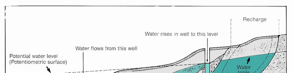
12 Groundwater terms zone of aeration: portion of soil and rock near the surface in which open spaces are filled primarily with air (a.k.a vadose zone) saturated zone: zone in which pore spaces are filled with water water table: boundary between zone of aeration and saturated zone aquifer: body of rock that is water permeable to yield significant quantities 12
13 Groundwater Table 13
14 The water table When water travels through the infiltration, the zone where most of the pore spaces are filled with air is called - Unsaturated zone (zone of aeration). Where most of the pore spaces and fractures of the rock are filled with water is called Saturated zone. 14
15 Groundwater Movement in Temperate Regions 15
16 Figure
17 Wet Period 17
18 Dry Period 18
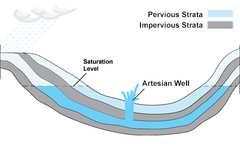
19 More groundwater terms aquifer: body of rock that is sufficiently water permeable to yield economically significant quantities to wells and springs aquitard: body of rock that retards but does not prevent flow of water to or from an adjacent aquifer: Ex: Shale, Mudstone aquiclude: body of relatively impermeable rock that is capable of absorbing water slowly but does not transmit it rapidly enough to supply a well or spring: Ex: Impermeable bedrock 19
20 20 Basin Hydrologic Cycle GW/SW Interaction
21 General classification of aquifers Aquifer : is a geologic formation which is water bearing or water saturated. Capable of yielding sufficient amount of water for economical withdrawal. Aquifers can be divided into several groups unconfined aquifers confined aquifers semi confined aquifers 21
22 AQUIFERS AND THEIR CHARACTERISTICS 22
23 II. Aquifer Types A. Unconfined


24 1. Unconfined aquifers Also called as water table aquifers or free ground water aquifers. This is a permeable bed only partly filled with water and overlying a relatively impermeable layer. Its upper boundary is formed by a free water table under atmospheric pressure. water in the unconfined aquifers called unconfined water or phreatic water. 24
25 II. Aquifer Types B. Confined

26 2. Confined aquifers (Artesian aquifers) Confined aquifer is completely saturated aquifer whose upper and lower boundaries are impermeable. In confined aquifers pressure of water is usually higher than atmospheric pressure. Water in confined aquifer is not open to atmosphere. 26
27 Confined Aquifer 27
28 Water in the wells of this aquifer can above the top the aquifer. The level which the water rises in wells in a confined aquifer is called the piezometric level. Water in the confined aquifer-artesian water or Piezometric water. 28
29 II. Aquifer Types A. Unconfined B. Confined C. Artesian

30 C. Artesian
31 II. Aquifer Types A. Unconfined B. Confined C. Artesian D. Perched
32 Perched aquifers This can be occurred in unconfined aquifers. 32
33 Springs Locations where a perched water table intersects the ground 33
34 Perched Water Table 34
35 E. Potentiometric Surface and Water Table

36 Recharge Natural Precipitation Melting snow Infiltration by streams and lakes Artificial Recharge wells Water spread over land in pits, etc Small dams in stream channels to detain and deflect water 36

37 Flow in Aquifers 37
38 38 Other Aquifer Features
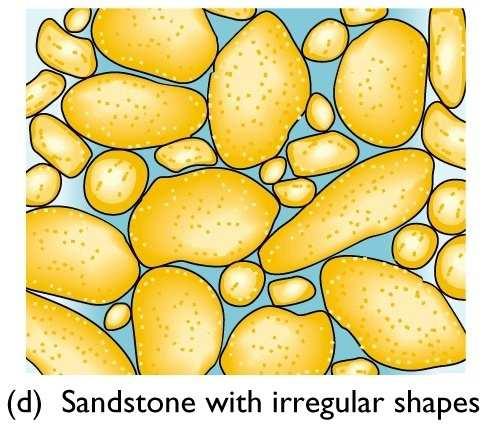
39 3. Semi confined aquifers is a completely saturated aquifer that is bounded above by semi permeable layer, below by an impermeable layer. 39
40 4. Aquitard this is also a geologic formation which has insufficient water movement but appreciable leakage. 40
41 5. Aquiclude This is also a geologic formation. Generally water tight. 41
42 Aquiclude between an unconfined aquifer and a confined aquifer 42
43 Geological characterization of the aquifer formations The nature and distribution of aquifers and aquitards in a geologic system are controlled by the lithology, stratigraphy and structure of the geologic deposits and formations. The lithology is the physical makeup, including the mineral composition, grain size and grain packing of the sediments or rocks that make up the geological systems. The stratigraphy describes the geometrical and age relations between the various lenses, beds and formations in geologic systems of sedimentary origin. Structural features, such as cleavages, fractures, folds and faults are the geometrical properties of the geologic systems produced by deformation after deposition or crystallization. 43
44 Influence of stratigraphy and structure on regional aquifer occurrence: a) gently deeping sandstone aquifers with outcrops along mountain front; b) interfingering sand and gravel aquifers in intermountain basin; c) faulted and folded aquifer 44


45 Soils and rocks are not completely solid. porosity: portion of volume of a material that consists of open spaces permeability: measure of the speed at which fluid can travel through a porous medium Imagine two vertical pipes, one filled with gravel, one with sand. Out of which one will the water flow faster? 45
46 Properties of aquifers 1. Porosity and permeability. (1). Porosity Porosity of a water bearing formation is its aggregate volume of openings as a percentage of total volume. Eg: clay is highly porous. Porosity is an index of how much ground water can be in the saturated material. Porosity in the sediment is formed during deposition. Porosity are developed during the formation of the rock. 46

47 Primary porosity: The main or original porosity system in a rock or unconfined alluvial deposit. Is control by the Grain shape Sorting Packing Degree of sedimentation 1. Shape of the grain Better inter granular opens High Porosity Less inter granular opens Less Porosity 47

48 2. Sorting Well-sorted Poorly-sorted 48
49 3. Packing cubic packing (low porosity) Rhombohedral packing (low porosity) 4. Degree of sedimentation highly cemented low porosity not well cemented high porosity 49
50 Secondary porosity: A subsequent or separate porosity system in a rock, often enhancing overall porosity of a rock. This can be a result of chemical leaching of minerals or the generation of a fracture system A) solution cavities more cavities- high porosity less cavities- low porosity B) factures or joints more fractures and joints- high porosity porosity specific yield clay 45-55% 1-10% sand 35-40% 10-30% gravel 30-40% 15-30% sand & gravel 20-35% 15-20% sandstone 10-20% 5-15% shale/ limestone 1-10% 0.5-5% 50
51 51
52 Specific yield Specific yield, also known as the drainable porosity, is a ratio, less than or equal to the effective porosity, indicating the volumetric fraction of the bulk aquifer volume that a given aquifer will yield when all the water is allowed to drain out of it under the forces of gravity: sp. Yield= w/v*100% w: the volume of water drained, V: the total rock or material volume The quantity of water is released by a unit volume is called the specific yield When water is drained from saturated material under the force of gravity, only a part of the total volume stored in the pores is released. 52
53 Specific Retention The part of water that is not removed by the gravity is held by the molecular attraction The quantity of water that retains in the unit volume is called specific retention sp. retention = u/v*100% u: the volume of water retained, V: the total rock or material volume 53
54 Porosity porosity=sp. yield + sp. retention 54
55 55
56 Permeability This is also called Hydraulic conductivity. Capacity of a porous medium for transmitting water. Permeability of porous material depends on several factors, Size of the pores Degree of pores interconnection The texture of the medium Degree of cementation highly cemented-low permeability. The movement of ground water from one pace to another in a material will take place whenever a difference in the pressure head occurs between two points. (commonly symbolized as κ, or k) is a measure of the ability of a porous material (often, a rock or unconsolidated material) to transmit fluids. 56
57 Rates of groundwater movement Slow to very slow (depending on permeability) Generally within the range of 10 to 100 cm per day Can be described with Darcy s law 57
58 Darcy s Law in the mid of 19 th century Henry Darcy made first systematic study of the movement of the ground water through a porous medium. The rate of flow through the porous medium is proportional to the head loss and is inversely proportional to the length of the flow path. V h 1-h 2 V 1/ l V= k(h 1 -h 2 )/l Where, k- hydraulic conductivity-- unit-length/time or velocity V- velocity of the flow (h1-h2)- head loss( difference in the hydraulic head) l- length of the flow path k is also called Permeability coefficient h 1 -h 2 /l is called Hydraulic gradient =I V=kI 58
59 Permeability co-efficient V =ki VA=kIA Q =kia k =Q/IA Q = Quantity of water flow Units = m/s Is the quantity of flow through a unit cross sectional area of a porous material per unit time under unit hydraulic gradient. e.g. Permeability co- efficient of some materials. clay m/day silt 10-1 m/day fine sand m/day coarse sand 10 2x10 2 m/day gravel m/day 59
60 Darcy s Experiment (1856): Flow rate determined by Head loss, dh = h 1 - h 2 60
61 Darcy s Law 61
62 Groundwater Flow Driven by hydraulic gradients Q = K I A K is hydraulic conductivity A is cross sectional area I is hydraulic gradient
63 Conditions Darcy s Law holds for: 1. Saturated flow and unsaturated flow 2. Steady-state and transient flow 3. Flow in aquifers and aquitards 4. Flow in homogeneous and heterogeneous systems 5. Flow in isotropic or anisotropic media 6. Flow in rocks and granular media 63
![Transmissivity (T) T K Transmissivity of a porous medium is the rate of flow per unit width of the aquifer through the entire thickness under a hydraulic gradient is one [unit hydraulic gradient].](/docs-images/89/101184996/images/64-0.jpg "T=KD K-permeability co-efficient D-aquifer thickness Storage co-efficient (S) Storage co-efficient of an aquifer is the volume of water released or taken into storage by per unit surface of the")
64 Transmissivity (T) T K Transmissivity of a porous medium is the rate of flow per unit width of the aquifer through the entire thickness under a hydraulic gradient is one [unit hydraulic gradient]. T=KD K-permeability co-efficient D-aquifer thickness Storage co-efficient (S) Storage co-efficient of an aquifer is the volume of water released or taken into storage by per unit surface of the aquifer per unit decline or rise of the head. Storage co-efficient S in Unconfined aquifer : Confined aquifer :
65 Darcy Velocity V is the specific discharge (Darcy velocity). Specific discharge has units of velocity. The specific discharge is a macroscopic concept, and is easily measured. It should be noted that Darcy s velocity...from the microscopic velocities associated with the actual paths if individual particles of water as they wind their way through the grains of sand. The microscopic velocities are real, but are probably impossible to measure. 65
66 Darcy & Seepage Velocity Darcy velocity is a fictitious velocity since it assumes that flow occurs across the entire cross-section of the soil sample. Flow actually takes place only through interconnected pore channels. A v voids A = total area 66
67 Darcy & Seepage Velocity From the Continuity Eqn: Q = A v D = A V V s Where: Q = flow rate A = total cross-sectional area of material A V = area of voids V s = seepage velocity V D = Darcy velocity 67
68 Darcy & Seepage Velocity Therefore: V S = V D ( A/A V ) Multiplying both sides by the length of the medium (L) V S = V D ( AL / A V L ) = V D ( V T / V V ) Where: V T = total volume V V = void volume By Definition, V v / V T = n, the soil porosity Thus V S = V D / n 68
69 Drawdown Due to Pumping
70 Well Hydraulic Well is a hydraulic structure which permits to the economic withdrawal of water from a water bearing formation. Nature of converging flow When pumping started in a well the water level goes down / lowered. The amount of drop in water level is called Draw down (s). At a certain point the water level found to be un-affected according to the 1. Pumping rate 2.Aquifer properties 70
71 Recharging The force which drives water into well is, 1. Head difference between the water level and the water level any point outside the well. 2. Water moves from the aquifer to the well at all directions. From Darcy s law V=KI V=K.(h1-h2)/l V I Increasing velocity, I is increases. Slope of the water table also increases towards the well. The forms of this surface resembles a cone shaped depression, which is known as cone of depression. 71
72 Cone of Depression Size & shape of the depression depend on mainly pumping rate, length of pumping period, aquifer properties, slope of the water table, recharge within the zone of influence. Expansion of the cone of depression: With stop at the certain point, when the recharge become equal to pumping rate (Discharge) called steady state. 72
73 Discharge Draw down relationship at the steady state of the well. 1. For unconfined aquifers Q- discharge m3/day P- permeability m/day H- saturated thickness before pumping h - depth of water during pumping R- radius of influence r radius of the well 73
74 2. For confined aquifers Q- discharge m3/day P- permeability m/day H- statistic head at the bottom of the well h - depth of water during pumping R- radius of influence r radius of the well m thickness of aquifer 74
75 Aquifer type and ground water environment According to the climate & geologic condition aquifer type and ground water environment vary. Geologically & climatically aquifers can be divided into following groups. Alluvial aquifers Glacial aquifers Carbonate rocks Sandstone & shale aquifers Coastal aquifers Volcanic terrains Crystalline rocks Arid regions 75


76 1. Alluvial aquifers Alluvium contain clastic material of recent geologic age found only in terrestrial sediment. Three major types. Alluvial fan Alluvial plains Deltaic terrain 76

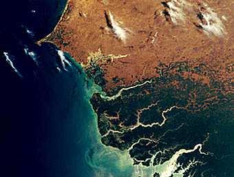
77 Alluvial fan Alluvial fans are found when a stream leaves its inclined mountain path and enters to a plane. sediments contain different particle sizes. Porosity of the aquifer reduced due to mud/clay flow and cementation. Generally quality of the ground water of the alluvial fan is good. 77
78 Alluvial Fans Characteristics: Coarse grained, poorly sorted, very heterogeneous mixture of mostly rock fragments, sand and mud. 78
79 79

80 Alluvial plains Large alluvial plane. A complex of lens shaped gravel, silt, clay. An alluvial plain is a relatively flat landform created by the deposition of sediment over a long period of time by one or more rivers coming from highland regions, from which alluvial soil forms 80
81 Delta deposits Deltaic deposits are formed when a river dump much more material than the sea. These sediments contain fine sand and silt. Include deposits of mud and sand that accumulate at river mouths: Ex: Mississippi River Delta Characteristics: Fine grained Wide range of sizes Contain both marine and non-marine fossils Mud cracks 81
82 82

83 2. Glacial terrain Cover large area in northern hemisphere, small area in southern hemisphere. Glacial terrains are formed by glaciers where melted dumpings, the unsorted load of sediments in the melting areas. This type of sediments are called glacial till Till can often form a ridge type - Moraine Thickness and type of till can vary from few meters to several 10 s of meters. Characteristics: Poorly sorted and less rounded Wide range of sizes Compositional varieties 83

84 Streams already dumped unsorted materials and bring them further downstream. Broader downstream are called outwash gravel, those aquifer are shallow but good aquifers Ground water prospecting in glacial terrains is mainly the outwash gravel deposits. Ex: Norway, Sweden 84
85 Figure - Aquifer occurrence in the glaciated regions 85
86 3. Volcanic terrain Volcanic terrain are built by lava, ash and pyroclastic deposits. Lava formations can have primary porosity due to gas bubbles Generally, Lava formations are good aquifers Main disadvantage of the volcanic aquifer Toxic elements present in this ground water. E.g. B, As, Cd, F 86
87 4. Arid regions In this region ground water is recharging mainly by seepage from stream/lake. Infiltration is in minor scale. Poor water quality is the major problem. 87
88 5. Sand stone - Shale aquifers Sequence of alternative arrangement of sandstone and shale or clay are called sand stone shale aquifers. Deposition of these sequence mainly in 1. Marine sedimentary environment 2. Terrestrial sedimentary environment 3. Delta sedimentary environment Often form confined aquifers. 88
89 6. Carbonate rocks Main composition of the carbonate rocks are MgCo3,CaCo3 e.g. Lime stone - CaCo3 Dolomite - CaCo3. MgCo3 Thickness of the carbonate aquifers is greater than 10s of meters & form potential aquifers. Springs are characteristics feature of the carbonate rock aquifers 89
90 7. Coastal aquifers Generally coastal aquifers contains: Wedge of sediments resting on the seaward inclined surface. Marine & terrestrial sediments are common in this type of aquifers. Differences of sediments mainly due to sea level fluctuations. 90
ρ f g. Under static condition P B =P A h s ρ s g = (h s +h f ) ρ f g h f = h s ρ s g/ρ f g h s h f = (ρ s -ρ f ) (h s /ρ f ) ρ f = 1; ρ s =1.")
91 The surface between saline water and fresh water is called fresh water saline water interface, mainly formed due to density differences of fresh water and saline water. P B =h s ρ s g. P A =(h s +h f )ρ f g. Under static condition P B =P A h s ρ s g = (h s +h f ) ρ f g h f = h s ρ s g/ρ f g h s h f = (ρ s -ρ f ) (h s /ρ f ) ρ f = 1; ρ s =1.025 h s = 40 h f 91
92 Saltwater intrusion Pumping of groundwater diverts groundwater from flowing toward sea seawater movement toward aquifer Causes deterioration of water quality in coastal aquifers

93 Locating the Interface Ghyben-Herzberg relation

94 Ghyben-Herzberg Relation Weight of column of freshwater extending from water table to interface Hydrostatic conditions: = weight of column of saltwater extending from sea level to the same depth
95 Ghyben-Herzberg Relation: ρ gz ρ g h z = ( + ) s f f ρ f = freshwater density = 1.0g/cm 3 ρ s = saltwater density = 1.025g/cm 3 z = height of saltwater column h f = hydraulic head above sea level h f + z = height of freshwater column z = s ρ f ρ ρ f h f z = 40h f
96 Ghyben-Herzberg Relation: z = 40h f The depth to the interface between freshwater and saltwater is approximately 40 times the height of the water table above sea level
97 A tube well If the ground water table elevation above sea level is h f at the same point saline water-fresh water interface lie at the depth of 40h f By lowering of ground water table by 1 unit race the saline water- fresh water interface by 40 units. Pumping in coastal aquifer has to be done very carefully. 97
98 8. Crystalline rock (Hard rock Aquifers) Rocks of igneous and metamorphic origin are called crystalline rocks, Eg: 90% of Sri Lankan rocks are crystalline rocks. This crystalline rocks are poor aquifers due to lack or absence of primary porosity. They secondary porosity developed due to fracturing/ joint or weathering or both. Un-weathered / crystalline rocks Storage capacity depends on the Interconnectivity of fractures & joints or fissures Weathering process- mechanical weathering (can develop secondary porosity) - chemical weathering (can increase 98 already developed porosity)
99 There is a link between degree of weathering and degree of fracturing More fracture rocks- more developed weathering. Less fracture rocks- less developed weathering (more resistant to weathering) On regional scale topography is a good indication for identify fracture zones or weathering formed rocks. Detailed geological mapping is useful in determining the fracture and joint intensities of different rocks. 99
100 Ground water quality G.W. is a solvent that is in contact with Earth materials. As a result, ground water contains dissolved cations & anions. Major ions contain in natural water, Ca 2+, Na +,K +,Mg 2+, CO 3 2-,HCO 3-,Cl -,SO 4 2- Dissolved gases in natural water, N 2,O 2,CO 2,H 2 S,CH 4 There are many ions in natural water as small concentration Minor- NO 3-,Fe,Mn,F - Trace- Pb, Cd, Hg, As, S 100
101 Units of measurements Chemical analysis of water Basis weight of the solute per volume of the solvent units mg/l or ppm (parts per million)- no of parts by weight of the solute in one million parts by weight of the solution. 101
102 Water Quality Standard vary from country to country. Most accepted standards in worldwide are WHO water quality standards. Parameter Maximum desirable Maximum allowable limit limit TDS (Total dissolved 500 mg/l 2000 mg/l Solids) Turbidity 5 NTU 25 NTU Hardness (50-100) mg/l 600 mg/l Cl- 250 mg/l 300 mg/l SO mg/l 400 mg/l NO3-10 mg/l 50 mg/l F- 1 mg/l 1.5 mg/l Fe2+/Fe3+.3 mg/l 1 mg/l As,Cr,Pb.05 mg/l 1 mg/l Cd.005 mg/l.01 mg/l Hg 0.0 mg/l 0.0 mg/l 102
103 Ground Water Exploration Main objective Aquifers -what type of aquifers? -where the aquifers -How to explore -How good are the aquifer quantity &quality Well site are select based on hydro geological conditions, 1. Adequate yield 2. Water quality 3. Minimum cost User ground water exploration yield water quality minimum cost I. Tube well water from fractures of hard rock II. Dug well overburden well. 103
104 Ground water exploration has five levels of investigation 1. Inventory of existing data Geological data Hydrogeological data Climatic data Existing well data 2. Remote sensing interpretation satellite images Aerial photographs 3. Hydro geological field observation/ field work Geomorphological analysis Water point inventory & monitoring Hydro climatic monitoring 4. Geophysical survey Electric resistance Seismic refraction Electro magnetic property 104
105 5. Drilling Hand drilling Machine drilling Geological logging Geophysical logging Water sampling Inventory of existing data Topographic map Target population Infrastructure and access roads Identification of existing water supplies Data from existing bore holes can find aquifer locations, yield, ground water fluctuations. From bore holes can take the information about geology & ground water condition. Climatic & hydro geologic data recharge, rainfall, climatic variation Geologic map about the geology, soil type. 105
106 Remote sensing interpretation - satellite images useful for having information about large area. - Aerial photographs useful to locate target community Both can be verified during field observation. 106
107 Hydro geological field observation Basic elements of hydrogeological field observations 1) Geomorphology. 2) Water availability. Field verification of 1. Water levels. 2. Yield & quality of wells, springs and surface water bodies. 3. Local drainage and vegetation pattern. 4. Ground water movement & fluctuation. 3) Human resources Knowledge of local people History of water bodies and springs Water requirement Human settlements Alternative water bodies 107
108 Exploration of Groundwater Surface exploration - non-invasive" ways to map the subsurface. -less costly than subsurface investigations 1. Geologic methods 2. Remote Sensing 3. Surface Geophysical Methods (a) Electric Resistivity Method (b) Seismic Refraction Method (c) Seismic Reflection Method (d) Gravimetric Method (e) Magnetic Method (f) Electromagnetic Method (g) Ground Penetrating Radar and others Subsurface exploration 1. Test drilling geologic log drilling time log Water level measurement 2. Geophysical logging/borehole geophysics Resistivity logging Spontaneous potential logging Radiation logging Temperature logging Caliper Logging Fluid Conductivity logging Fluid velocity logging 3. Tracer tests and others
109 Geophysical investigation (survey) Indirect characterization of - subsurface geology measuring at the surface some of their - Geological structures physical properties - Underground structures Electric resistivity Density Conductivity Travel time for seismic waves For ground water investigation Commonly used Electric resistivity Seismic refraction Electro magnetic method 109
110 Geophysical survey - Have two uses in ground investigation 1. Filling in detail between bore holes 2. Searching a large area for anomalies before drilling. Low cost compared to multiple bore holes 1) Ground Probing Radar (GPR) Trolley mounted transmitter record micro EM radar signals. 2) Electric survey Resistivity survey measure ground water investigation 3) Seismic survey 4) Magnetic survey Record the of earth magnetic field Instrument - Proton magnetometer low cost one man operation 5) Gravity survey Record minute variations in earth s gravitational force Instrument Gravimeter High cost 110

 and I is the current")
111 Electric Resistivity Method Electrical resistivity is the resistance of a volume of material to the flow of electrical current. Groundwater explorati withdraw Surface Groundwater geophysical exploration methods Electric Surface resistivity geophysical methods current is introduced into the ground through a pair of current electrodes resulting potential difference is measured between another pair of potential electrodes Apparent resistivity is then calculated as: ρ a = 2πa V I V is the measured Potential difference (in Volts) and I is the current introduced (in Amperes).


112 Electric Resistivity Method Groundwater explorati Surface geophysical methods Electric resistivity Wenner arrangement ρ Schlumber configuration a = 2πa V I ρ a = π 2 ( L/ 2) ( b/ 2) b 2 V I


113 Vertical electrical Sounding (VES) Changing the spacing of electrodes changes the depth of penetration of the current. So it is possible to obtain field curve of apparent resistivity vs depth. For a single homogeneous, isotropic layer of infinite thickness, resistivity curve will be a straight line. Groundwater explorati Surface geophysical methods Electric resistivity

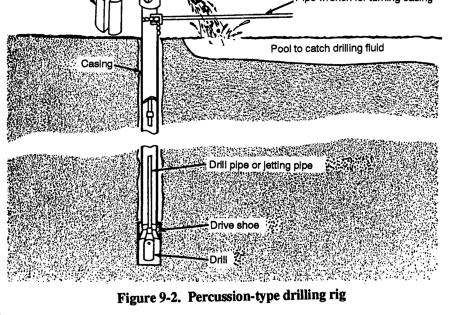
114 Profiling or lateral traversing Electrode separation is kept constant for 2 to 3 values (say a=10 m, 15 m, 20 m) and the center of electrode spacing is moved from one station to another (grid points) to have the same constant electrode separations. Used to detect subsurface changes in horizontal direction. Wenner method is most convenient for this. Horizontal and vertical measurements allow to produce an iso-resistivity contour diagram.


115 Interpretation 1. Qualitative: from shape of the curves, decipher number of layers and resistivity relationships 2. Quantitative: (i) Analytical methods (mass curves or type curves)
116 Interpretation 1. Qualitative: from shape of the curves, decipher number of layers and resistivity relationships 2. Quantitative: (i) Analytical methods (mass curves or type curves) (ii) Empirical methods - Cumulative resistivity method - Inverse slope method Electrode spacing (a) Cumulative resistivity method (log scale) ρ a Semi-log paper 1 2πR Inverse slope method Electrode spacing, a
117 Usefulness valuable in determining -the depth and thickness of groundwater aquifers Groundwater explorati withdraw Surface Groundwater geophysical exploration methods Electric Surface resistivity geophysical methods Resistivities vary over a wide range, depending on density, porosity, pore size and shape, water content and quality, and temperature. - the depth to groundwater, the depth and thickness of clay layers -in some cases the depth to bedrock, and accordingly limit the depth of well drilling.


118 Groundwater explorati withdraw Surface Groundwater geophysical exploration methods Electric Surface resistivity geophysical methods In relatively porous formations, resistivity is controlled more by water content and quality within the formation than by the rock resistivity. For aquifers composed of unconsolidated materials, the resistivity decreases with the degree of saturation and the salinity of the groundwater. Clay minerals conduct electric current through their matrix, therefore, clayey formations tend to display lower resistivities than do permeable alluvial aquifers.
 located on the")
119 Seismic refraction method based on the measurement of the travel time of seismic waves refracted at the interfaces between subsurface layers of different velocity. Groundwater withdraw Surface geophysical methods Seismic refraction Seismic energy is provided by a source (hammer, weight drop or small explosive charge) located on the surface.

120 The seismic waves travel through the subsurface at a velocity dependent on the density of the soil/rock. When the seismic wave front encounters an interface where seismic velocity drastically increases, a portion of the wave critically refracts at the interface, traveling laterally along higher velocity layers. Due to compressional stresses along the interface boundary, a portion of the wave front returns to the surface Groundwater withdraw Surface geophysical methods Seismic refraction A series of seismic receivers, geophones (right) are laid out along the survey line at regular intervals and receive the reflected wave energy.
121 Vo V1 V2 Groundwater explorati Surface geophysical methods Seismic refraction For horizontal two-layer case: X V2 V Z 1 1 = 2 V2 + V1 t2 V2 V Z 1 1 = V2 V1 Z1 = V V V V t 2x X V 2 Data are recorded on a seismograph and later downloaded to computer for analysis of the first-arrival times to the geophones from each shot position. Travel-time versus distance graphs are then constructed and velocities calculated for the refractor layers For horizontal three-layer case: Z 2 = V V V V 2 2 t3 Z 2 1 V V V V Seismic refraction methods are effective in formations with definite boundaries between strata and where density increases with each successive lower layer
122 Exploration drilling Purpose To collect data from test bore holes to evaluate the potential for production wells. Test pumping - Performance of the well - Hydraulic parameters of aquifer - Yield & draw down - Water quality 122
123 Finalize the Tube well Water supply Drilling for water supply Drilling is the excavation of deep narrow holes with vertical walls. cuttings have to be removed from bore holes vertical walls have to be prevented. Fundamental of drilling Drilling methods mainly depends on 1. Formation 2. Drilling depth 3. Number of holes 4. Availability of machines 5. Support service 6. Cost. 123
124 Principles of drilling 1. Cable tool percussion drilling method very old method(1000 years old) 2. Core drilling Not used in ground water investigation Used in mineral exploration and engineering geology Take undisturbed core samples 3. Rotary drilling method 124
 One of the modern drilling method Faster Suitable for")
125 4. Reverse rotary drilling method Flow of fluid is reverse. 5. Pneumatic percussion drilling (DTH) One of the modern drilling method Faster Suitable for soft & hard formation. 125
126 126
11/22/2010. Groundwater in Unconsolidated Deposits. Alluvial (fluvial) deposits. - consist of gravel, sand, silt and clay
 deposits. - consist of gravel, sand, silt and clay") Groundwater in Unconsolidated Deposits Alluvial (fluvial) deposits - consist of gravel, sand, silt and clay - laid down by physical processes in rivers and flood plains - major sources for water supplies
Groundwater in Unconsolidated Deposits Alluvial (fluvial) deposits - consist of gravel, sand, silt and clay - laid down by physical processes in rivers and flood plains - major sources for water supplies
Prof. Stephen A. Nelson EENS 111. Groundwater
 Page 1 of 8 Prof. Stephen A. Nelson EENS 111 Tulane University Physical Geology This page last updated on 20-Oct-2003 is water that exists in the pore spaces and fractures in rock and sediment beneath
Soils, Hydrogeology, and Aquifer Properties. Philip B. Bedient 2006 Rice University
 Soils, Hydrogeology, and Aquifer Properties Philip B. Bedient 2006 Rice University Charbeneau, 2000. Basin Hydrologic Cycle Global Water Supply Distribution 3% of earth s water is fresh - 97% oceans 1%
 12 10 8 6 4 2 0 40-50 50-60 60-70 70-80 80-90 90-100 Fresh Water What we will cover The Hydrologic Cycle River systems Floods Groundwater Caves and Karst Topography Hot springs Distribution of water in
Chapter 13. Groundwater
 Chapter 13 Groundwater Introduction Groundwater is all subsurface water that completely fills the pores and other open spaces in rocks, sediments, and soil. Groundwater is responsible for forming beautiful
Groundwater Hydrology
 EXERCISE 12 Groundwater Hydrology INTRODUCTION Groundwater is an important component of the hydrologic cycle. It feeds lakes, rivers, wetlands, and reservoirs; it supplies water for domestic, municipal,
Surface Processes Focus on Mass Wasting (Chapter 10)
") Surface Processes Focus on Mass Wasting (Chapter 10) 1. What is the distinction between weathering, mass wasting, and erosion? 2. What is the controlling force in mass wasting? What force provides resistance?
Surface Processes Focus on Mass Wasting (Chapter 10) 1. What is the distinction between weathering, mass wasting, and erosion? 2. What is the controlling force in mass wasting? What force provides resistance?
LECTURE 10. Module 3 : Field Tests in Rock 3.6 GEOPHYSICAL INVESTIGATION
 LECTURE 10 3.6 GEOPHYSICAL INVESTIGATION In geophysical methods of site investigation, the application of the principles of physics are used to the study of the ground. The soil/rock have different characteristics
Essentials of Geology, 11e
 Essentials of Geology, 11e Groundwater Chapter 10 Instructor Jennifer Barson Spokane Falls Community College Geology 101 Stanley Hatfield Southwestern Illinois Co Jennifer Cole Northeastern University
6.1 Water. The Water Cycle
 6.1 Water The Water Cycle Water constantly moves among the oceans, the atmosphere, the solid Earth, and the biosphere. This unending circulation of Earth s water supply is the water cycle. The Water Cycle
' International Institute for Land Reclamation and Improvement. 2 Groundwater Investigations. N.A. de Ridder'? 2.1 Introduction. 2.
 2 Groundwater Investigations N.A. de Ridder'? 2.1 Introduction Successful drainage depends largely on a proper diagnosis of the causes of the excess water. For this diagnosis, one must consider: climate,
WATER ON AND UNDER GROUND. Objectives. The Hydrologic Cycle
 WATER ON AND UNDER GROUND Objectives Define and describe the hydrologic cycle. Identify the basic characteristics of streams. Define drainage basin. Describe how floods occur and what factors may make
DATA ACQUISITION METHODS FOR GROUNDWATER INVESTIGATION AND THE SITING OF WATER SUPPLY WELLS
 DATA ACQUISITION METHODS FOR GROUNDWATER INVESTIGATION AND THE SITING OF WATER SUPPLY WELLS M.B.J. Foster Tetra Tech EM Inc., San Francisco, CA, USA Keywords: Groundwater, water wells, drilled wells, geophysical
RIVERS, GROUNDWATER, AND GLACIERS
 RIVERS, GROUNDWATER, AND GLACIERS Delta A fan-shaped deposit that forms when a river flows into a quiet or large body of water, such as a lake, an ocean, or an inland sea. Alluvial Fan A sloping triangle
Groundwater. (x 1000 km 3 /y) Oceans Cover >70% of Surface. Groundwater and the. Hydrologic Cycle
 Oceans Cover >70% of Surface. Groundwater and the. Hydrologic Cycle") Chapter 17 Oceans Cover >70% of Surface Groundwater and the Hydrologic Cycle Vasey s Paradise, GCNP Oceans are only 0.025% of Mass Groundwater Groundwater is liquid water that lies in the subsurface in
Chapter 17 Oceans Cover >70% of Surface Groundwater and the Hydrologic Cycle Vasey s Paradise, GCNP Oceans are only 0.025% of Mass Groundwater Groundwater is liquid water that lies in the subsurface in
1 Water Beneath the Surface
 CHAPTER 16 1 Water Beneath the Surface SECTION Groundwater KEY IDEAS As you read this section, keep these questions in mind: What are two properties of aquifers? How is the water table related to the land
Groundwater. (x 1000 km 3 /y) Reservoirs. Oceans Cover >70% of Surface. Groundwater and the. Hydrologic Cycle
 Reservoirs. Oceans Cover >70% of Surface. Groundwater and the. Hydrologic Cycle") Chapter 13 Oceans Cover >70% of Surface Groundwater and the Hydrologic Cycle Oceans are only 0.025% of Mass Groundwater Groundwater is liquid water that lies in the subsurface in fractures in rocks and
Chapter 13 Oceans Cover >70% of Surface Groundwater and the Hydrologic Cycle Oceans are only 0.025% of Mass Groundwater Groundwater is liquid water that lies in the subsurface in fractures in rocks and
FUNDAMENTALS OF ENGINEERING GEOLOGY
 FUNDAMENTALS OF ENGINEERING GEOLOGY Prof. Dr. HUSSEIN HAMEED KARIM Building and Construction Engineering Department 2012 Preface The impulse to write this book stemmed from a course of geology given by
Surface Water and Stream Development
 Surface Water and Stream Development Surface Water The moment a raindrop falls to earth it begins its return to the sea. Once water reaches Earth s surface it may evaporate back into the atmosphere, soak
Lecture Outlines PowerPoint. Chapter 5 Earth Science 11e Tarbuck/Lutgens
 Lecture Outlines PowerPoint Chapter 5 Earth Science 11e Tarbuck/Lutgens 2006 Pearson Prentice Hall This work is protected by United States copyright laws and is provided solely for the use of instructors
Prentice Hall EARTH SCIENCE
 Prentice Hall EARTH SCIENCE Tarbuck Lutgens Running Water and Groundwater Running Water The Water Cycle Water constantly moves among the oceans, the atmosphere, the solid Earth, and the biosphere. This
Groundwater Sustainability at Wadi Al Bih Dam, Ras El Khaimah, United Arab Emirates (UAE) using Geophysical methods
 using Geophysical methods") Groundwater Sustainability at Wadi Al Bih Dam, Ras El Khaimah, United Arab Emirates (UAE) using Geophysical methods Ahmed Murad, Amir Gabr, Saber Mahmoud, Hasan Arman & Abdulla Al Dhuhoori Geology Department
Groundwater Sustainability at Wadi Al Bih Dam, Ras El Khaimah, United Arab Emirates (UAE) using Geophysical methods Ahmed Murad, Amir Gabr, Saber Mahmoud, Hasan Arman & Abdulla Al Dhuhoori Geology Department
Sediment and sedimentary rocks Sediment
 Sediment and sedimentary rocks Sediment From sediments to sedimentary rocks (transportation, deposition, preservation and lithification) Types of sedimentary rocks (clastic, chemical and organic) Sedimentary
Geophysics for Environmental and Geotechnical Applications
 Geophysics for Environmental and Geotechnical Applications Dr. Katherine Grote University of Wisconsin Eau Claire Why Use Geophysics? Improve the quality of site characterization (higher resolution and
What is a water table? What is an aquifer? What is the difference between a spring and a well?
 CHAPTER 11 3 Water Underground SECTION The Flow of Fresh Water BEFORE YOU READ After you read this section, you should be able to answer these questions: What is a water table? What is an aquifer? What
Chapter 14. Groundwater
 Chapter 14 Groundwater Importance of groundwater! Groundwater is water found in the pores of soil and sediment, plus narrow fractures in bedrock! Groundwater is the largest reservoir of fresh water that
Land subsidence due to groundwater withdrawal in Hanoi, Vietnam
 Land Subsidence (Proceedings of the Fifth International Symposium on Land Subsidence, The Hague, October 1995). 1AHS Publ. no. 234, 1995. 55 Land subsidence due to groundwater withdrawal in Hanoi, Vietnam
What we will cover. The Hydrologic Cycle. River systems. Floods. Groundwater. Caves and Karst Topography. Hot springs
 Fresh Water What we will cover The Hydrologic Cycle River systems Floods Groundwater Caves and Karst Topography Hot springs On a piece of paper, put these reservoirs of water in to order from largest to
Instructor : Dr. Jehad Hamad. Chapter (7)
") Instructor : Dr. Jehad Hamad Chapter (7) 2017-2016 Soil Properties Physical Properties Mechanical Properties Gradation and Structure Compressibility Soil-Water Relationships Shear Strength Bearing Capacity
Instructor : Dr. Jehad Hamad Chapter (7) 2017-2016 Soil Properties Physical Properties Mechanical Properties Gradation and Structure Compressibility Soil-Water Relationships Shear Strength Bearing Capacity
L.O: SLOWING STREAMS DEPOSIT (SORT) SEDIMENT HORIZONTALLY BY SIZE.
 SEDIMENT HORIZONTALLY BY SIZE.") L.O: SLOWING STREAMS DEPOSIT (SORT) SEDIMENT HORIZONTALLY BY SIZE. 1. Base your answer to the following question on the profile shown below, which shows the pattern of horizontal sorting produced at a
L.O: SLOWING STREAMS DEPOSIT (SORT) SEDIMENT HORIZONTALLY BY SIZE. 1. Base your answer to the following question on the profile shown below, which shows the pattern of horizontal sorting produced at a
Module 1 : Site Exploration and Geotechnical Investigation
 Objectives In this section you will learn the following Displacement borings Wash boring Auger boring Rotary drilling Percussion drilling Continuous sampling Boring methods of exploration The boring methods
NC Earth Science Essential Standards
 NC Earth Science Essential Standards EEn. 2.1 Explain how processes and forces affect the Lithosphere. EEn. 2.1.1 Explain how the rock cycle, plate tectonics, volcanoes, and earthquakes impact the Lithosphere.
HYDROGEOLOGICAL PROPERTIES OF THE UG2 PYROXENITE AQUIFERS OF THE BUSHVELD COMPLEX
 R. Gebrekristos, P.Cheshire HYDROGEOLOGICAL PROPERTIES OF THE UG2 PYROXENITE AQUIFERS OF THE BUSHVELD COMPLEX R. Gebrekristos Digby Wells Environmental P. Cheshire Groundwater Monitoring Services Abstract
Lab 7: Sedimentary Structures
 Name: Lab 7: Sedimentary Structures Sedimentary rocks account for a negligibly small fraction of Earth s mass, yet they are commonly encountered because the processes that form them are ubiquitous in the
Name. 4. The diagram below shows a soil profile formed in an area of granite bedrock. Four different soil horizons, A, B, C, and D, are shown.
 Name 1. In the cross section of the hill shown below, which rock units are probably most resistant to weathering? 4. The diagram below shows a soil profile formed in an area of granite bedrock. Four different
Figure 1 The map shows the top view of a meandering stream as it enters a lake. At which points along the stream are erosion and deposition dominant?
 1. In which type of climate does chemical weathering usually occur most rapidly? 1. hot and dry 3. cold and dry 2. hot and wet 4. cold and wet 2. Figure 1 The map shows the top view of a meandering stream
Mass Wasting. Revisit: Erosion, Transportation, and Deposition
 Mass Wasting Revisit: Erosion, Transportation, and Deposition While landslides are a normal part of erosion and surface processes, they can be very destructive to life and property! - Mass wasting: downslope
mountain rivers fixed channel boundaries (bedrock banks and bed) high transport capacity low storage input output
 high transport capacity low storage input output") mountain rivers fixed channel boundaries (bedrock banks and bed) high transport capacity low storage input output strong interaction between streams & hillslopes Sediment Budgets for Mountain Rivers Little
mountain rivers fixed channel boundaries (bedrock banks and bed) high transport capacity low storage input output strong interaction between streams & hillslopes Sediment Budgets for Mountain Rivers Little
Mark S. Nordberg Geology and Groundwater Investigations Section North Central Region Office California Department of Water Resources
 Mark S. Nordberg Geology and Groundwater Investigations Section North Central Region Office California Department of Water Resources Ukiah Drought Workshop July 29, 2009 Groundwater 101 Groundwater is
Name: Mid-Year Review #2 SAR
 Name: Mid-Year Review #2 SAR Base your answers to questions 1 through 3 on on the diagram below, which shows laboratory materials used for an investigation of the effects of sediment size on permeability,
5. Which surface soil type has the slowest permeability rate and is most likely to produce flooding? A) pebbles B) sand C) silt D) clay A) B) C) D)
 pebbles B) sand C) silt D) clay A) B) C) D)") 1. During a heavy rainstorm, soil samples A and B both became saturated with water. However, 10 minutes after the storm ended, the soils appeared as shown below. Which statement best explains the observed
1. During a heavy rainstorm, soil samples A and B both became saturated with water. However, 10 minutes after the storm ended, the soils appeared as shown below. Which statement best explains the observed
EARTH SCIENCE 11 CHAPTER 9 NOTES WATER MOVING UNDERGROUND
 EARTH SCIENCE 11 CHAPTER 9 NOTES WATER MOVING UNDERGROUND KEY A. ALL THE WORLD S WATER 1. The world has an estimated one and one third thousand million cubic kilometers of water. 2. The earth s water is
*** ***! " " ) * % )!( & ' % # $. 0 1 %./ +, - 7 : %8% 9 ) 7 / ( * 7 : %8% 9 < ;14. " > /' ;-,=. / ١
 * % )!( & ' % # $. 0 1 %./ +, - 7 : %8% 9 ) 7 / ( * 7 : %8% 9 < ;14. > /' ;-,=. / ١") ١ ******!" #$ % & '!( ) % * ") +,-./ % 01. 3 ( 4 56 7/4 ) 8%9 % : 7 ;14 < 8%9 % : *7./ = ;-, >/'." Soil Permeability & Seepage ٢ Soil Permeability- Definition ٣ What is Permeability? Permeability is the
١ ******!" #$ % & '!( ) % * ") +,-./ % 01. 3 ( 4 56 7/4 ) 8%9 % : 7 ;14 < 8%9 % : *7./ = ;-, >/'." Soil Permeability & Seepage ٢ Soil Permeability- Definition ٣ What is Permeability? Permeability is the
Streams. Water. Hydrologic Cycle. Geol 104: Streams
 Streams Why study streams? Running water is the most important geologic agent in erosion, transportation and deposition of sediments. Water The unique physical and chemical properties of water make it
Which particle of quartz shows evidence of being transported the farthest distance by the stream? A) B) C) D)
 B) C) D)") 1. Base your answer to the following question on the block diagram below, which represents the landscape features associated with a meandering stream. WX is the location of a cross section. Location A
1. Base your answer to the following question on the block diagram below, which represents the landscape features associated with a meandering stream. WX is the location of a cross section. Location A
Name: Which rock layers appear to be most resistant to weathering? A) A, C, and E B) B and D
 A, C, and E B) B and D") Name: 1) The formation of soil is primarily the result of A) stream deposition and runoff B) precipitation and wind erosion C) stream erosion and mass movement D) weathering and biological activity 2)
Name: 1) The formation of soil is primarily the result of A) stream deposition and runoff B) precipitation and wind erosion C) stream erosion and mass movement D) weathering and biological activity 2)
Pratice Surface Processes Test
 1. The cross section below shows the movement of wind-driven sand particles that strike a partly exposed basalt cobble located at the surface of a windy desert. Which cross section best represents the
Which map shows the stream drainage pattern that most likely formed on the surface of this volcano? A) B)
 B)") 1. When snow cover on the land melts, the water will most likely become surface runoff if the land surface is A) frozen B) porous C) grass covered D) unconsolidated gravel Base your answers to questions
1. When snow cover on the land melts, the water will most likely become surface runoff if the land surface is A) frozen B) porous C) grass covered D) unconsolidated gravel Base your answers to questions
Geology 229 Engineering Geology. Lecture 6. Basic Rock Classification and Engineering Considerations (West, Chs. 2, 3, 4, 5)
") Geology 229 Engineering Geology Lecture 6 Basic Rock Classification and Engineering Considerations (West, Chs. 2, 3, 4, 5) Outline of this Lecture 1. Rock types and rock cycle 2. Geological and engineering
Geology 229 Engineering Geology Lecture 6 Basic Rock Classification and Engineering Considerations (West, Chs. 2, 3, 4, 5) Outline of this Lecture 1. Rock types and rock cycle 2. Geological and engineering
Sediment and Sedimentary rock
 Sediment and Sedimentary rock Sediment: An accumulation of loose mineral grains, such as boulders, pebbles, sand, silt or mud, which are not cemented together. Mechanical and chemical weathering produces
RESISTIVITY IMAGING AND BOREHOLE INVESTIGATION OF THE BANTING AREA AQUIFER, SELANGOR, MALAYSIA. A.N. Ibrahim Z.Z.T. Harith M.N.M.
 JOURNAL OF ENVIRONMENTAL HYDROLOGY The Electronic Journal of the International Association for Environmental Hydrology On the World Wide Web at http://www.hydroweb.com VOLUME 11 2003 RESISTIVITY IMAGING
UNIT 4 SEDIMENTARY ROCKS
 UNIT 4 SEDIMENTARY ROCKS WHAT ARE SEDIMENTS Sediments are loose Earth materials (unconsolidated materials) such as sand which are transported by the action of water, wind, glacial ice and gravity. These
Science EOG Review: Landforms
 Mathematician Science EOG Review: Landforms Vocabulary Definition Term canyon deep, large, V- shaped valley formed by a river over millions of years of erosion; sometimes called gorges (example: Linville
Why Study Groundwater?
 Groundwater Water filling open spaces in rock, sediment, and soil beneath the surface is called groundwater. This natural resource is as important to human endeavors as surface water. Groundwater is an
High Resolution Geophysics: A Better View of the Subsurface. By John Jansen, P.G., Ph.D., Aquifer Science and Technology
 High Resolution Geophysics: A Better View of the Subsurface By John Jansen, P.G., Ph.D., Aquifer Science and Technology Geologist Use Only Part of the Information Available To Them Most Geologist rely
TAKE HOME EXAM 8R - Geology
 Name Period Date TAKE HOME EXAM 8R - Geology PART 1 - Multiple Choice 1. A volcanic cone made up of alternating layers of lava and rock particles is a cone. a. cinder b. lava c. shield d. composite 2.
INTRODUCTION TO LOGGING TOOLS
 BY: MUHAMMAD ZAHID INTRODUCTION TO LOGGING TOOLS 1- SPONTANEOUS POTENTIAL (SP) The Spontaneous potential survey, (sp) was one of the first measurements, which was carried out, in a well bore. The SP log
Chapter 8 Fetter, Applied Hydrology 4 th Edition, Geology of Groundwater Occurrence
 Chapter 8 Fetter, Applied Hydrology 4 th Edition, 2001 Geology of Groundwater Occurrence Figure 8.42. Alluvial Valleys ground-water region. Fetter, Applied Hydrology 4 th Edition, 2001 Fetter, Applied
GEOL Introductory Geology: Exploring Planet Earth Fall 2010 Test #2 October 18, 2010
 GEOL 101 - Introductory Geology: Exploring Planet Earth Fall 2010 Test #2 October 18, 2010 Name KEY ID# KEY Multiple choice questions (2 points each). 1. What type of metamorphic rock is formed over large
1.72, Groundwater Hydrology Prof. Charles Harvey Lecture Packet #5: Groundwater Flow Patterns. Local Flow System. Intermediate Flow System
 1.72, Groundwater Hydrology Prof. Charles Harvey Lecture Packet #5: Groundwater Flow Patterns c Local Flow System 10,000 feet Intermediate Flow System Regional Flow System 20,000 feet Hydrologic section
Site Characterization & Hydrogeophysics
 Site Characterization & Hydrogeophysics (Source: Matthew Becker, California State University) Site Characterization Definition: quantitative description of the hydraulic, geologic, and chemical properties
ELECTRICAL RESISTIVITY TOMOGRAPHY
 NOTIO Association Clay Technological Centre C/ Río Cabriel s/n 45007 Toledo Tel.: 925 24 11 62 info@notio.es www.notio.es Page 1 / 7 SUMMARY 1. PHYSICAL FUNDAMENTALS OF THE... 3 1.1. ELECTRICAL BEHAVIOR
Connecticut's Aquifers
 Page 1 of 5 DEP Search: Connecticut's Aquifers The technical definition of the word "aquifer" is: any geologic formation capable of yielding significant quantities of water to wells. By that definition,
Page 1. Name:
 Name: 1) Which property would best distinguish sediment deposited by a river from sediment deposited by a glacier? thickness of sediment layers age of fossils found in the sediment mineral composition
Section I: Multiple Choice Select the best answer to each question. Mark your final answer on the answer sheet. (1 pt each)
") Sedimentary Rocks & Surface Processes Quest Name: Earth Science 2013 Block: Date: Section I: Multiple Choice Select the best answer to each question. Mark your final answer on the answer sheet. (1 pt each)
Sedimentary Rocks & Surface Processes Quest Name: Earth Science 2013 Block: Date: Section I: Multiple Choice Select the best answer to each question. Mark your final answer on the answer sheet. (1 pt each)
Karst found mostly in limestone (rock with at least 50% carbonate minerals), depends on 1) permeability & porosity
, depends on 1) permeability & porosity") KARST LANDFORMS produced by weathering & erosion in regions of carbonate rocks and evaporites processes called karstification mainly below ground surface predominantly underground drainage poorly-developed
KARST LANDFORMS produced by weathering & erosion in regions of carbonate rocks and evaporites processes called karstification mainly below ground surface predominantly underground drainage poorly-developed
Electrical prospecting involves detection of surface effects produced by electrical current flow in the ground.
 Electrical Surveys in Geophysics Electrical prospecting involves detection of surface effects produced by electrical current flow in the ground. Electrical resistivity method Induced polarization (IP)
1. The map below shows a meandering river. A A' is the location of a cross section. The arrows show the direction of the river flow.
 1. The map below shows a meandering river. A A' is the location of a cross section. The arrows show the direction of the river flow. Which cross section best represents the shape of the river bottom at
Chapter 7 Permeability and Seepage
 Permeability and Seepage - N. Sivakugan (2005) 1 7.1 INTRODUCTION Chapter 7 Permeability and Seepage Permeability, as the name implies (ability to permeate), is a measure of how easily a fluid can flow
Chapter 14: Groundwater. Fig 14.5b
 Chapter 14: Groundwater Fig 14.5b OBJECTIVES Recognize that groundwater is a vital source of accessible freshwater. Describe how groundwater forms below the water table. Explain the origin of aquifers,
UGRC 144 Science and Technology in Our Lives/Geohazards
 UGRC 144 Science and Technology in Our Lives/Geohazards Flood and Flood Hazards Dr. Patrick Asamoah Sakyi Department of Earth Science, UG, Legon College of Education School of Continuing and Distance Education
Geology and Soil Mechanics /1A ( ) Mark the best answer on the multiple choice answer sheet.
 Mark the best answer on the multiple choice answer sheet.") Geology and Soil Mechanics 55401 /1A (2003-2004) Mark the best answer on the multiple choice answer sheet. 1. Soil mechanics is the application of hydraulics, geology and mechanics to problems relating
Geology and Soil Mechanics 55401 /1A (2003-2004) Mark the best answer on the multiple choice answer sheet. 1. Soil mechanics is the application of hydraulics, geology and mechanics to problems relating
GEOL.3250 Geology for Engineers Glacial Geology
 GEOL.3250 Geology for Engineers Glacial Geology NAME Part I: Continental Glaciation Continental glaciers are large ice sheets that cover substantial portions of the land area. In the region of accumulation
UNIT 4: Earth Science Chapter 21: Earth s Changing Surface (pages )
") CORNELL NOTES Directions: You must create a minimum of 5 questions in this column per page (average). Use these to study your notes and prepare for tests and quizzes. Notes will be turned in to your teacher
CORNELL NOTES Directions: You must create a minimum of 5 questions in this column per page (average). Use these to study your notes and prepare for tests and quizzes. Notes will be turned in to your teacher
A. V T = 1 B. Ms = 1 C. Vs = 1 D. Vv = 1
 Geology and Soil Mechanics 55401 /1A (2002-2003) Mark the best answer on the multiple choice answer sheet. 1. Soil mechanics is the application of hydraulics, geology and mechanics to problems relating
4. The map below shows a meandering stream. Points A, B, C, and D represent locations along the stream bottom.
 1. Sediment is deposited as a river enters a lake because the A) velocity of the river decreases B) force of gravity decreases C) volume of water increases D) slope of the river increases 2. Which diagram
R.Suhasini., Assistant Professor Page 1
 UNIT I PHYSICAL GEOLOGY Geology in civil engineering branches of geology structure of earth and its composition weathering of rocks scale of weathering soils - landforms and processes associated with river,
Rocks Rock- A group of minerals, glass, mineroid bound together in some way.
 Rocks Rock- A group of minerals, glass, mineroid bound together in some way. All rocks fit into one of three categories: Igneous- formed by the cooling and hardening of hot molten rock Sedimentary- formed
Boreholes. Implementation. Boring. Boreholes may be excavated by one of these methods: 1. Auger Boring 2. Wash Boring 3.
 Implementation Boreholes 1. Auger Boring 2. Wash Boring 3. Rotary Drilling Boring Boreholes may be excavated by one of these methods: 4. Percussion Drilling The right choice of method depends on: Ground
Geology and New England Landscapes
 Geology and New England Landscapes Jim Turenne, CPSS USDA-NRCS Warwick, RI. http://nesoil.com Why Geology? Provides the big picture of site conditions. Major part of soil formation (parent material and
Wisconsin s Hydrogeology: an overview
 2012 Soil and Water Conservation Society Conference Stevens Point, WI Feb 9, 2012 Wisconsin s Hydrogeology: an overview Ken Bradbury Wisconsin Geological and Natural History Survey University of Wisconsin-Extension
Michigan s Geology and Groundwater
 Michigan s Geology and Groundwater Ralph J. Haefner Deputy Director U.S. Geological Survey Michigan-Ohio Water Science Center Lansing, Michigan Outline About the USGS Geology 101 Michigan s geology Bedrock
STUDY GUIDE FOR CONTENT MASTERY. Surface Water Movement
 Surface Water SECTION 9.1 Surface Water Movement In your textbook, read about surface water and the way in which it moves sediment. Complete each statement. 1. An excessive amount of water flowing downslope
Name: KEY OBJECTIVES HYDROLOGY:
 Name: KEY OBJECTIVES Correctly define: abrasion, capillarity, deposition, discharge, erosion, evapotranspiration, hydrology, impermeable, infiltration, meander, permeable, porosity, water table, weathering,
RAYMOND SIEVER Harvard University
 E A R T H FOURTH EDITION FRANK PRESS National Academy of Sciences RAYMOND SIEVER Harvard University W. H. Freeman and Company New York Preface xiii Acknowledgments xviii PART I PROLOGUE CHAPTER 1 HISTORY
STUDY GUIDE FOR CONTENT MASTERY. Movement and Storage of Groundwater
 Groundwater SECTION 10.1 Movement and Storage of Groundwater In your textbook, read about the hydrosphere, precipitation and groundwater, and groundwater storage. Use the following terms to complete the
C) D) 3. Which graph best represents the relationship between soil particle size and the rate at which water infiltrates permeable soil?
 D) 3. Which graph best represents the relationship between soil particle size and the rate at which water infiltrates permeable soil?") 1. Which earth material covering the surface of a landfill would permit the least amount of rainwater to infiltrate the surface? A) silt B) clay C) sand D) pebbles 2. Which graph best represents the relationship
1. Which earth material covering the surface of a landfill would permit the least amount of rainwater to infiltrate the surface? A) silt B) clay C) sand D) pebbles 2. Which graph best represents the relationship
Unit 4: Landscapes Practice Problems
 Name: Date: 1. Soil with the greatest porosity has particles that are A. poorly sorted and densely packed B. poorly sorted and loosely packed C. well sorted and densely packed D. well sorted and loosely
Weathering, Erosion, Deposition, and Landscape Development
 Weathering, Erosion, Deposition, and Landscape Development I. Weathering - the breakdown of rocks into smaller particles, also called sediments, by natural processes. Weathering is further divided into
Earth: The Water Planet
 Earth: The Water Planet Water is essential for living things to grow, reproduce, and carry out important processes. About 97% of Earth s water is salt water found in the ocean, while the other 3% is fresh
CE6301 ENGINEERING GEOLOGY UNIT I 2 MARKS
 YEAR : II SEMESTER : III DEPARTMENT : CIVIL CE6301 ENGINEERING GEOLOGY UNIT I 1. What is Physical weathering? 2. Define Stratigraphy and Palaeontology? 3. What is meant by chemical weathering 4. Describe
Occurs in Nature SOLID Inorganic (not from a plant or animal) Crystalline (forms crystals) Atoms / Molecules bond in a regular pattern
 Crystalline (forms crystals) Atoms / Molecules bond in a regular pattern") #12: Mineral Occurs in Nature SOLID Inorganic (not from a plant or animal) Crystalline (forms crystals) Atoms / Molecules bond in a regular pattern Regular Composition EX- Halite (salt) is always NaCl
#12: Mineral Occurs in Nature SOLID Inorganic (not from a plant or animal) Crystalline (forms crystals) Atoms / Molecules bond in a regular pattern Regular Composition EX- Halite (salt) is always NaCl
GEOLOGY CURRICULUM. Unit 1: Introduction to Geology
 Chariho Regional School District - Science Curriculum September, 2016 GEOLOGY CURRICULUM Unit 1: Introduction to Geology OVERVIEW Summary In this unit students will be introduced to the field of geology.
Evaluation of Subsurface Formation of Pabna District, Bangladesh
 IOSR Journal of Applied Geology and Geophysics (IOSR-JAGG) e-issn: 2321 0990, p-issn: 2321 0982.Volume 1, Issue 4 (Sep. Oct. 2013), PP 30-36 Evaluation of Subsurface Formation of Pabna District, Bangladesh
Hydraulic properties of porous media
 PART 5 Hydraulic properties of porous media Porosity Definition: Void space: n V void /V total total porosity e V void /V solid Primary porosity - between grains Secondary porosity - fracture or solution
Unit 3 Review - Surface Processes
 Unit 3 Review - Surface Processes 1. Why is the surface of Mercury covered with meteor impact craters, while Earth s surface has relatively few craters? A) Mercury is larger than Earth, so it gets hit
B) color B) Sediment must be compacted and cemented before it can change to sedimentary rock. D) igneous, metamorphic, and sedimentary rocks
 color B) Sediment must be compacted and cemented before it can change to sedimentary rock. D) igneous, metamorphic, and sedimentary rocks") 1. Which characteristic of nonsedimentary rocks would provide the least evidence about the environment in which the rocks were formed? A) structure B) color C) crystal size D) mineral composition 2. Which
1. Which characteristic of nonsedimentary rocks would provide the least evidence about the environment in which the rocks were formed? A) structure B) color C) crystal size D) mineral composition 2. Which
GEOLOGY MEDIA SUITE Chapter 5
 UNDERSTANDING EARTH, SIXTH EDITION GROTZINGER JORDAN GEOLOGY MEDIA SUITE Chapter 5 Sedimentation Rocks Formed by Surface Processes 2010 W.H. Freeman and Company Mineralogy of sandstones Key Figure 5.12
Introduction to Soil Mechanics Geotechnical Engineering-II
 Introduction to Soil Mechanics Geotechnical Engineering-II ground SIVA Dr. Attaullah Shah 1 Soil Formation Soil derives from Latin word Solum having same meanings as our modern world. From Geologist point
Lecture Outline Wednesday - Friday February 14-16, 2018
 Lecture Outline Wednesday - Friday February 14-16, 2018 Quiz 2 scheduled for Friday Feb 23 (Interlude B, Chapters 6,7) Questions? Chapter 6 Pages of the Past: Sedimentary Rocks Key Points for today Be