Geochemistry of Landscapes Covered by Glacially Crushed Debris. William W. Shilts
|
|
|
- Shana Jordan
- 5 years ago
- Views:
Transcription

1 Geochemistry of Landscapes Covered by Glacially Crushed Debris William W. Shilts
2
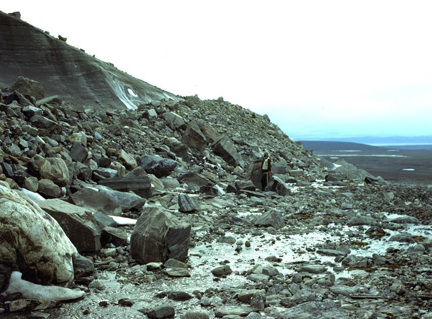
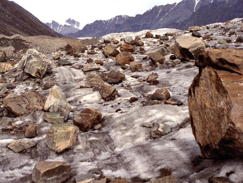
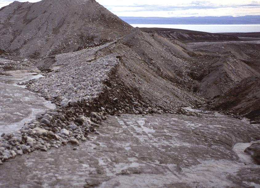
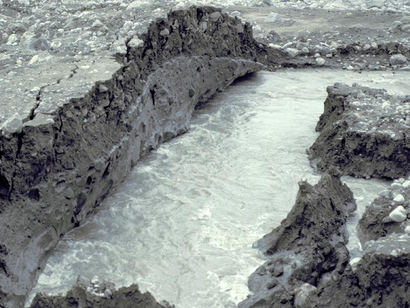
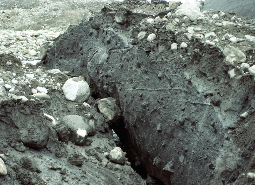
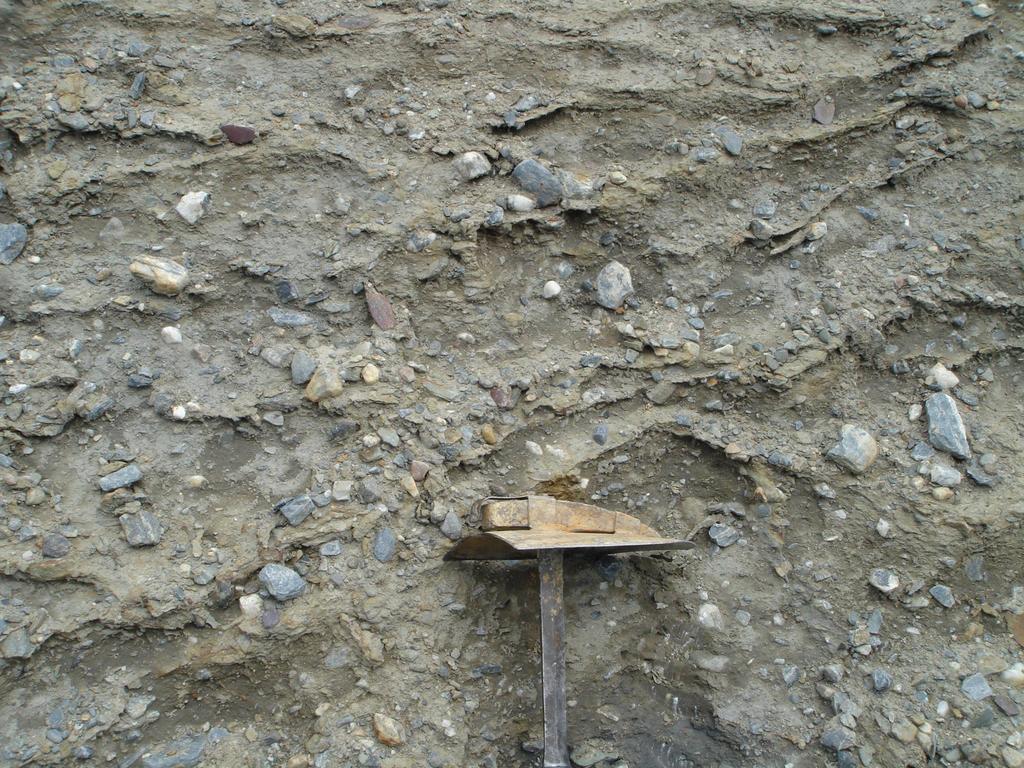
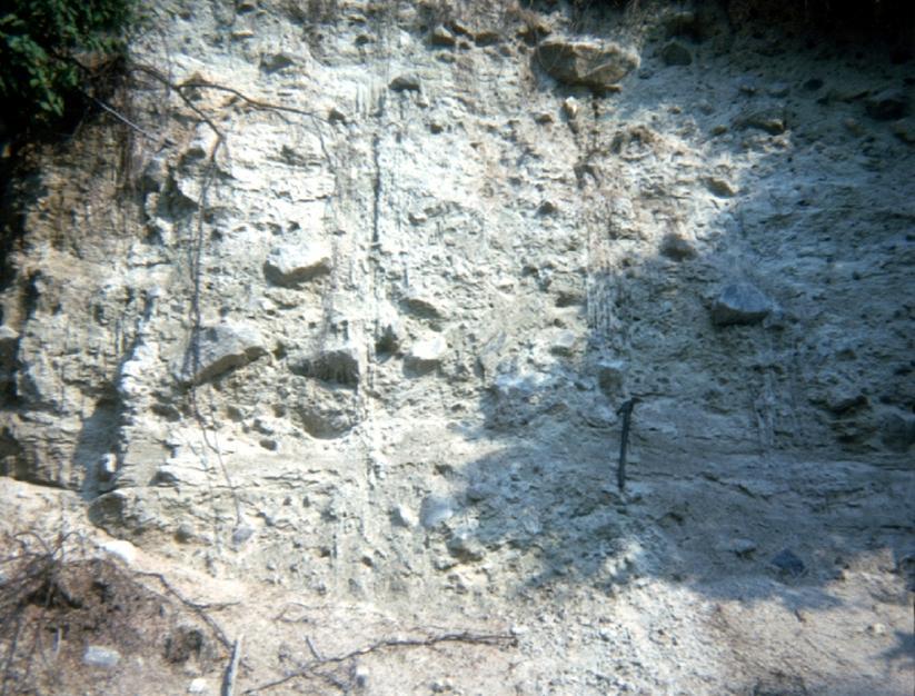
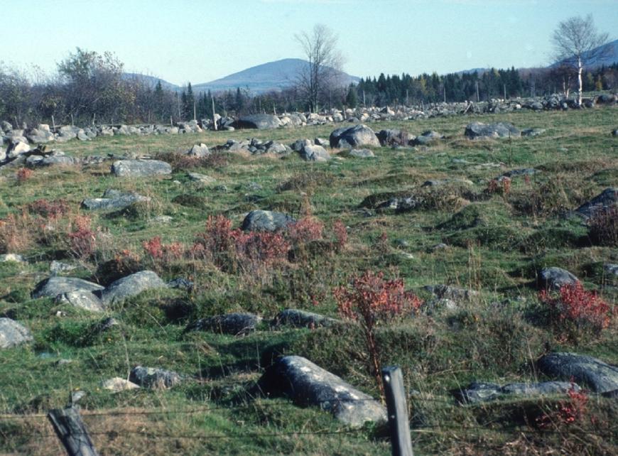
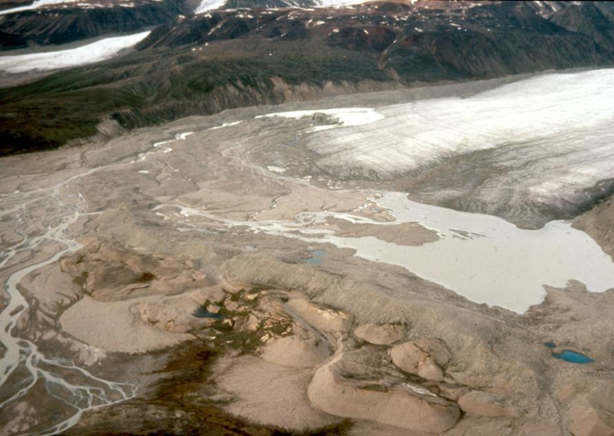
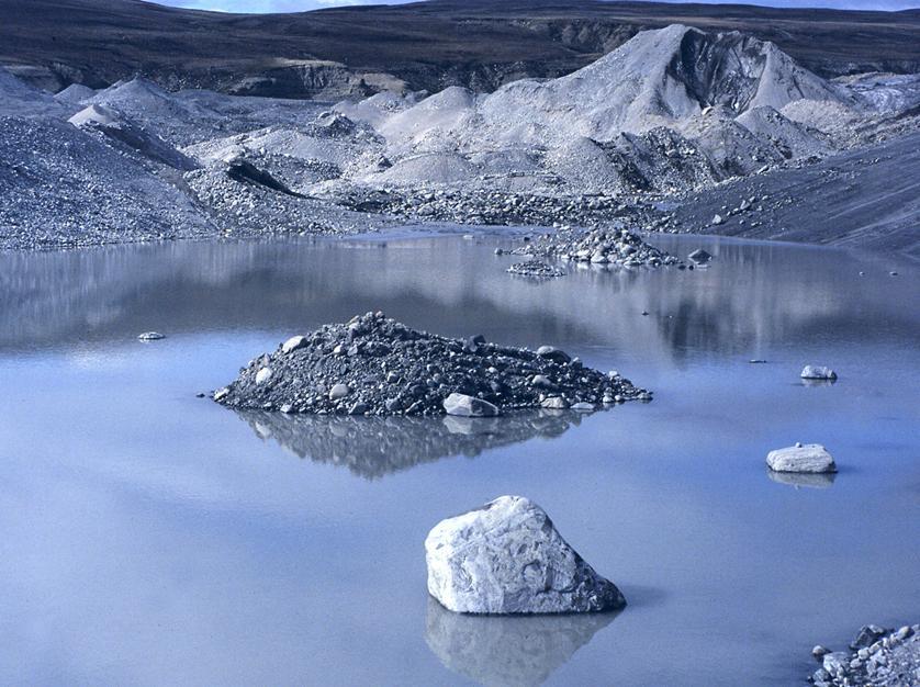
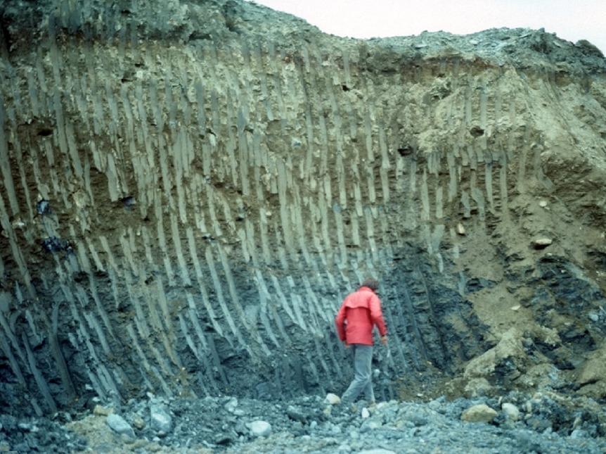
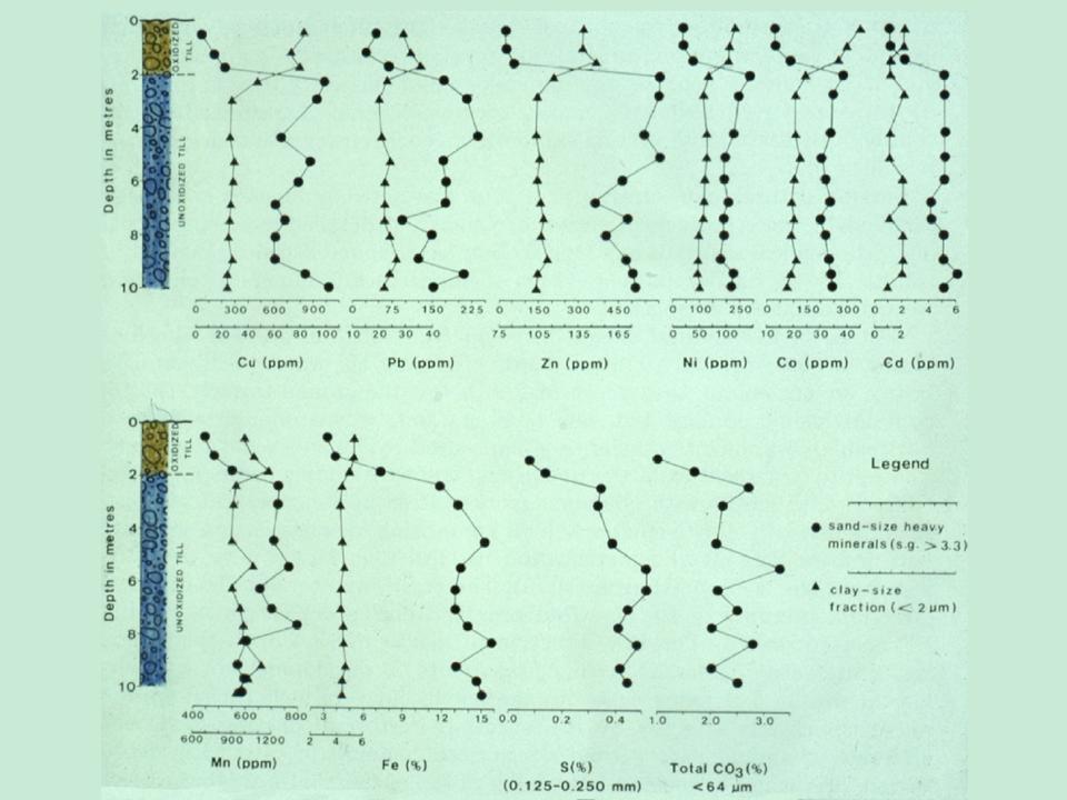
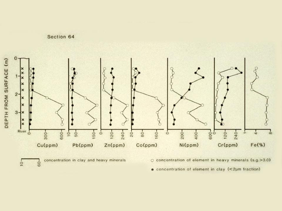
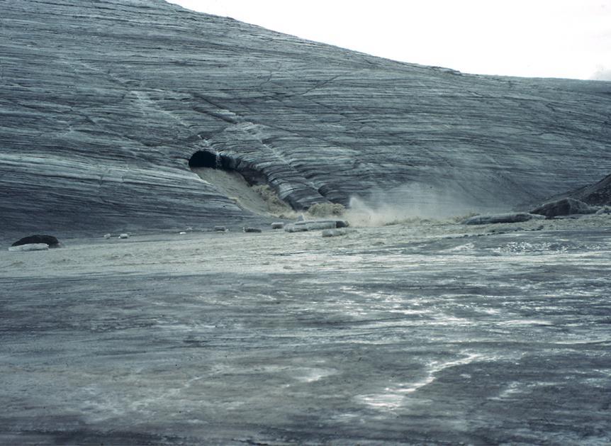
3 Comminution (crushing) processes dominate glacial sediment production and deposition, trumping chemical weathering, hydrology, and gravity, which dominate in other sedimentary environments. Comminution processes create terminal grades, typical for every rock and mineral. Chemical partitioning in glacial sediments is directly related to physical partitioning of minerals. Glaciers carry a dense load of debris at their base, some debris in the englacial position and some on their surface. Depending on the topography of the glacial bed, any of these compositionally distinct primary glacial sediment facies may be deposited one on the other. The proglacial sedimentary environment may consist of several distinctly different sedimentary environments that follow the retreating glacier front as a glacier retreats. Though all sediments in these environments are ultimately derived from the glacial load, they vary chemically, particularly through diagenesis and weathering.
4 Crushed, unweathered bedrock provides abundant labile minerals which are easily weathered. Once crushed debris is entrained in ice, it is transported with little lateral or vertical mixing. Preexisting sediment, soil, or bedrock may be entrained by freezing on at the glacier s base and transported with little deformation or degradation. Entrained debris is diluted down-ice exponentially, by constant basal entrainment or deposition of debris along flow lines.

5
6
7
8
9
10
11
12
13
14
15
16
17
18

19

20
21
22

23
24
25
26
27
28
29

30
31
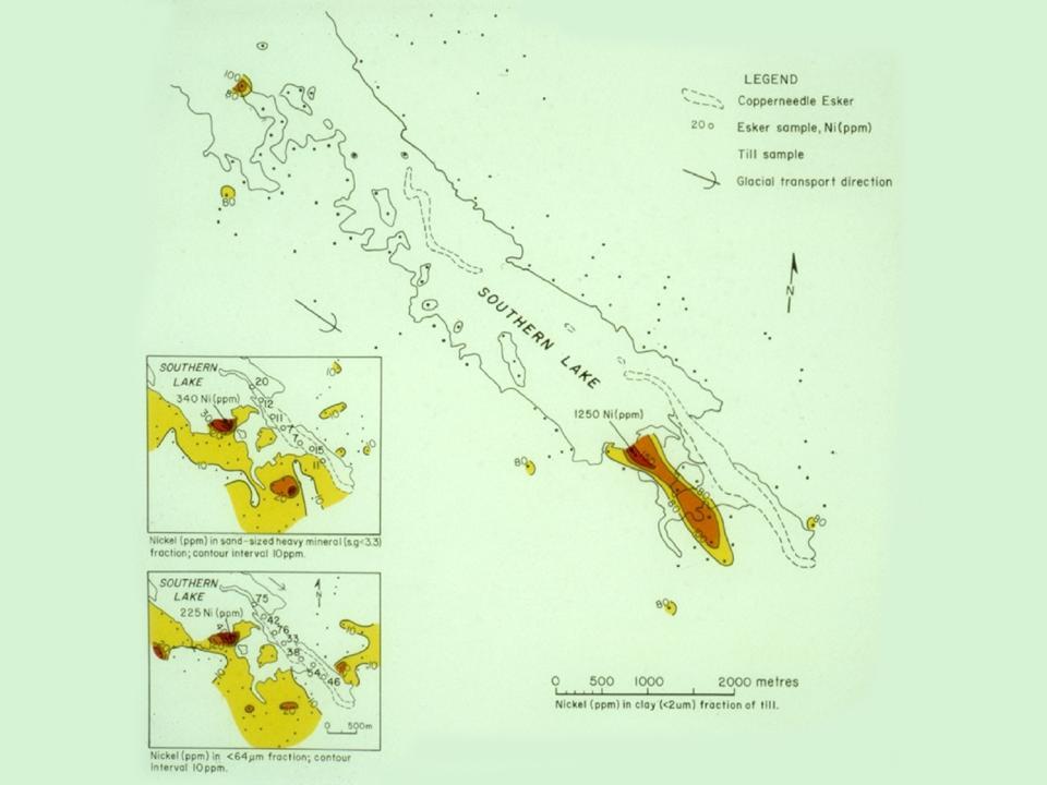
32
33

34

35
36
37

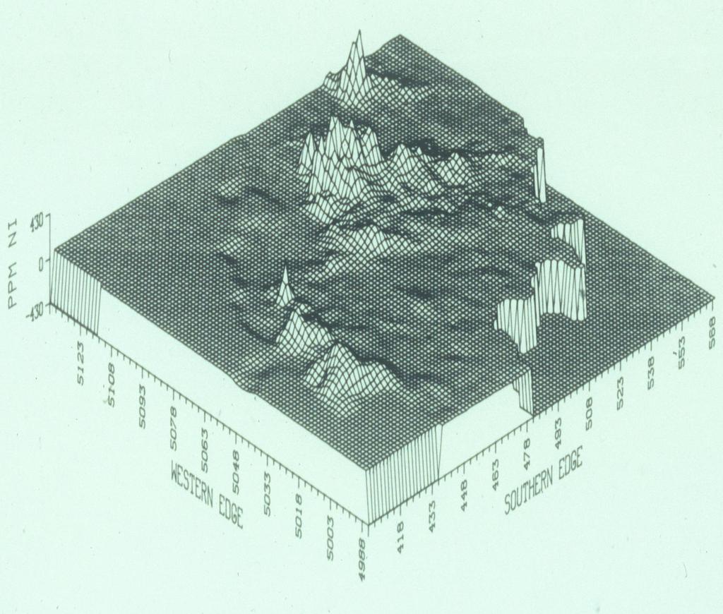
38

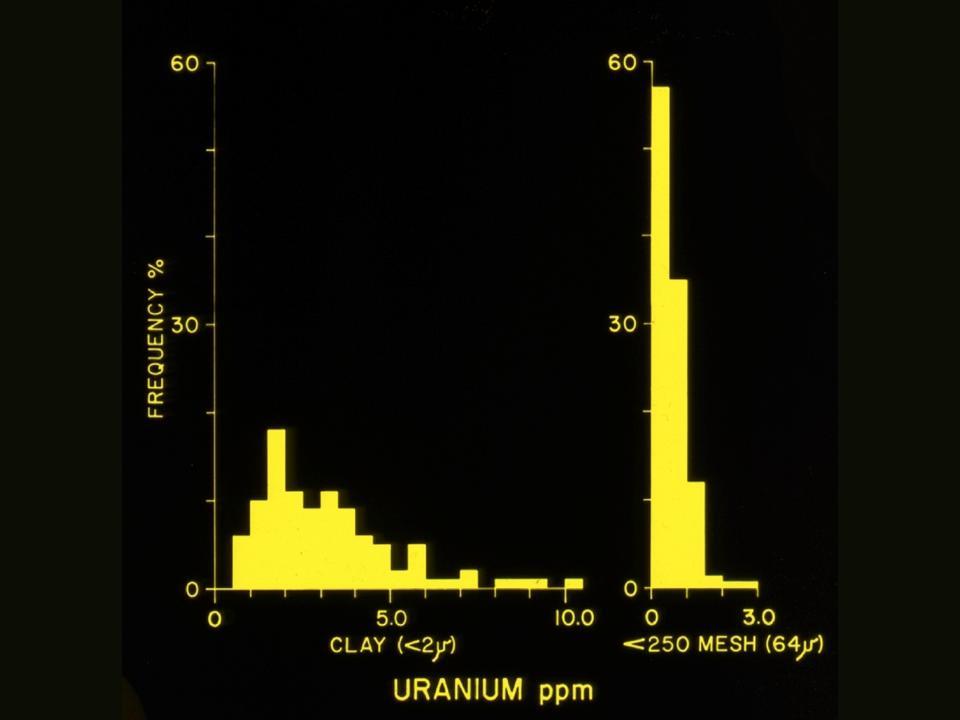
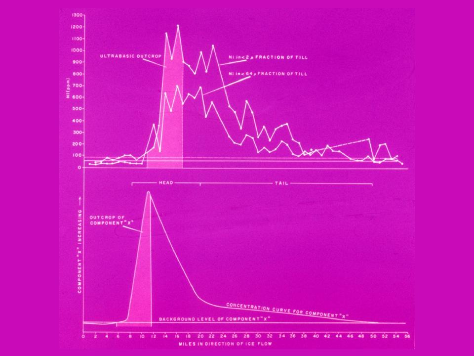
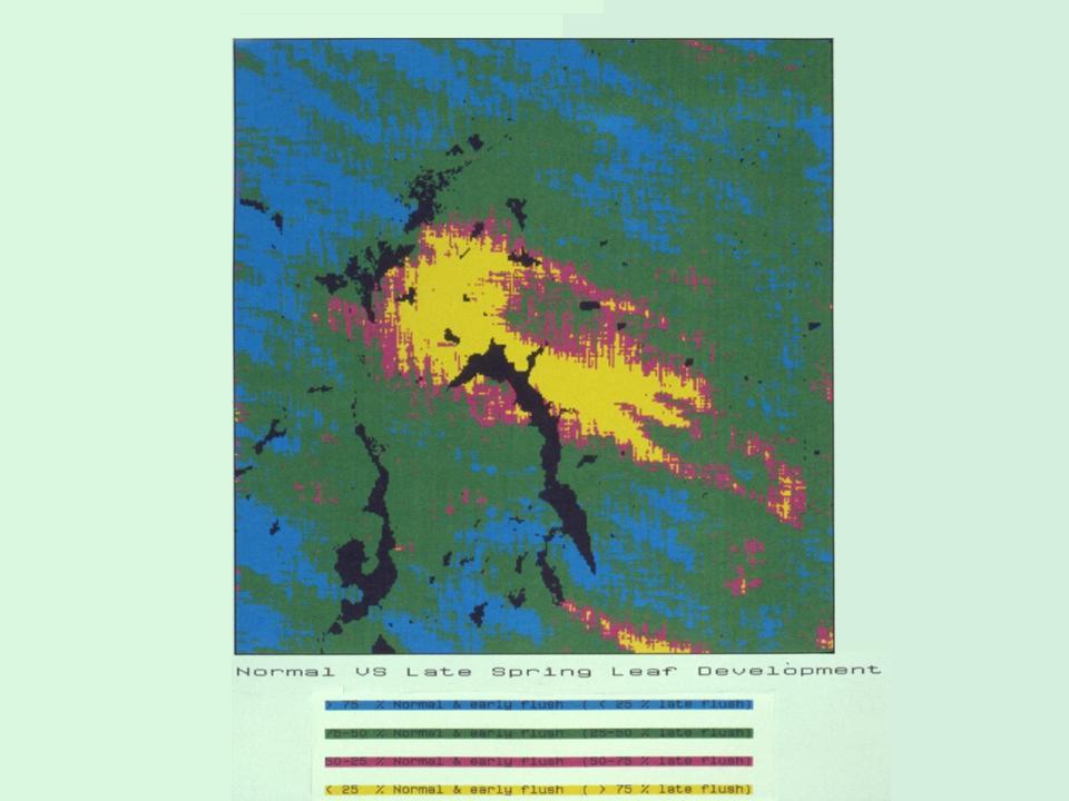
39 1138 ppm Cr; 2300 ppm Ni <100 ppm Cr; <60 ppm Ni

40 1250 ppm Ni 110 ppm Ni
41
42
43

44

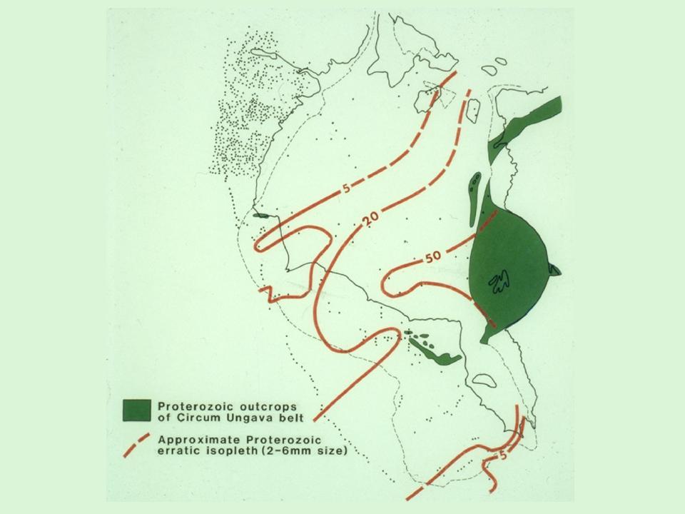
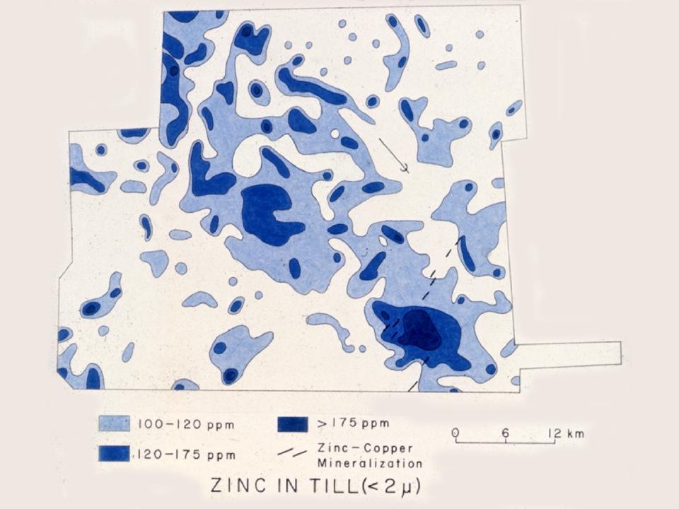
45 Nickel Concentrations (ppm) in < 63 um fraction of till
46 SCALES OF GLACIAL DISPERSAL Continental S KM Regional s KM Local s KM Detailed <1 KM
47
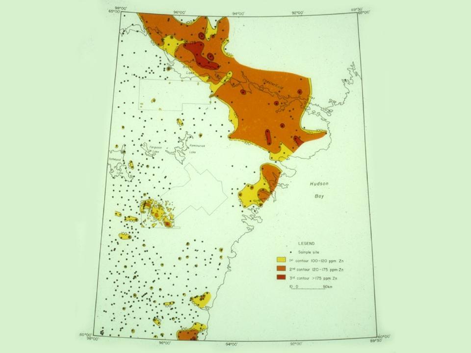
48
49

50
51
52 The passage of a continental glacier over any landscape causes widespread natural pollution while providing easily released nutrients; glacial dispersal is independent of drainage divides as basal debris is transported up and down gradients.
53
54

55 Map of natural As concentrations in till and other glacial sediments (<2 um fraction). The overall pattern reflects the distribution pattern of As sulphide-rich metasedimentary and metavolcanic bedrock in the area. This area was extensively mined for gold which when processed, produced arsenical tailings that have contaminated many drainage basins.
56
57
58
59 Programme and Abstracts 25th International Applied Geochemistry Symposium August 2011 Rovaniemi, Finland Pertti Sarala, V. Juhani Ojala and Marja-Leena Porsanger Publisher: Vuorimiesyhdistys - Finnish Association of Mining and Metallurgical Engineers, Serie B, Nro B92-1, Rovaniemi 2011
60 Sarala, P., Ojala, V.J. and Porsanger, M.-L Programme and abstracts. The 25th International Applied Geochemistry Symposium 2011, August 2011, Rovaniemi, Finland. Vuorimiesyhdistys - Finnish Association of Mining and Metallurgical Engineers, Serie B 92-1, 192 pages. Layout: Irma Varrio ISBN (printed) ISBN (CD) ISBN (PDF) ISSN Vuorimiesyhdistys This volume is available from: Vuorimiesyhdistys ry. Kaskilaaksontie 3 D ESPOO Electronic version: or Printed in: Painatuskeskus Finland Oy, Rovaniemi
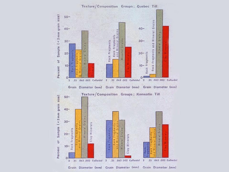
61 52 A need to harmonize methodologies was detected and international co-operation was getting stronger. The role of Finnish geochemists in the activities of IGCP 259 (International Geochemical Mapping) and IGCP 360 (Global Geochemical Baselines) was remarkable. These projects were conducted by A. Darnley. A. Björklund and N. Gustavsson from GTK are among the authors of the Blue book (Darnley et al. 1995), which is today the basic document when geochemical mapping projects are planned in Africa, Asia, America or Europe. One of the main results of the international geochemical mapping projects until now is the Foregs Geochemical Atlas of Europe (Salminen et al. 2005). This project was initiated by the IGCP 360. Future of the geochemistry has already started. In the 2000s, new ideas and applications came to exploration geochemistry. Spatial data analysis which uses geochemical mapping data as one element together with other geological information was taken into use. The younger generation started to develop and apply new methods and technologies in exploration and in medical geology. Applications of stable isotopes will be one of the key issues in the future. In environmental geochemistry, risk analysis in the connection of contaminated land sites will need more detailed information from speciation of elements and their bioavailability. Geochemists expertise in developing methods for cleaning contaminated land is needed. The data and information which geochemists have demands them also to participate actively in social debate and preparation of legislation. References: Darnley, et al., Earth Science 19, UNESCO Publishing Salminen et al Geochemical Atlas of Europe. Geological Survey of Finland Keynote 5 Geochemistry of Landscapes Covered by Glacially Crushed Debris William W. Shilts Prairie Research Institute, University of Illinois-Urbana, Champaign, USA Sediment carried by modern glaciers and sediment covering formerly glaciated terrain is created largely by comminution (crushing) processes that dominate sediment production and generate virtually unweathered, fresh bedrock detritus (till). Entrained debris is and was diluted exponentially down ice by constant incorporation of debris at the base of a glacier. Because glaciers flow up and down slopes, gravity plays a secondary role in determining distribution of sediment components, and the geochemical signature of glacial sediment can be draped over the landscape, irrespective of topography, except in areas of mountain glaciation. Conversely, in areas unaffected by glaciations, soils and sediments are produced largely through the processes of chemical and physical weathering of source rocks, and gravity or chemical processes dominate the depositional patterns of sediments dispersed by wind or water. Glacial comminution processes create terminal grades which are defined as the sizes to which rocks and their constituent mineral phases can be reduced, given the energy available at the base of a glacier (Driemanis and Vagners, 1971). This physical partitioning of minerals into specific size grades based on their physical properties and on their size distribution in source rocks results in chemical partitioning that is related to the mix of mineral phases derived from the various bedrock lithologies traversed by the depositing glacier. For example, chromium can be concentrated in Chromite or Uvarovite, which are hard, uncleavable minerals with terminal grades in the sand-sizes, or in Fuchsite, a chromium-bearing mica, which has a terminal grade in the clay or <4 micron size fraction. Thus, if an ultramafic source rock is rich in Chromite, its geochemical signature will be most prominent in the sand fraction of a glacial sediment, whereas glacial abrasion of Fuchsite-rich ultramafic rocks will produce a glacial sediment in which chrome is concentrated in the <4 micron sizes. From this example it can be seen that in order to interpret geochemical analyses of glacial sediment samples, the concept of terminal grades must be carefully considered. Another result of the crushing process is that as minerals are reduced to progressively finer sizes, the reaction surface area of the sediment increases, enhancing the release or adsorption of chemical components, such as nutrients and (natural) pollutants. Finally, till or water and wind-deposited sediment derived from till, contain easily weathered mineral phases (carbonates, sulphides, some clays, etc.) that can be altered to significant depths, with accompanying release of chemical components. Consequently, sampling and interpretation strategies for weathered samples, even those collected below the true solum, must take into account these weathering characteristics. Reference: Driemanis, A. and Vagners, U. J. (1971). Bimodal distribution of rock and mineral fragments in basal tills. In: Till: A Symposium, R. P. Goldthwait, ed., pp Ohio State University Press, Columbus.
INTRODUCTION Prospectivity mapping Study area and methods
 Quaternary geological and till geochemical studies in verifying GIS-based prospectivity mapping in the Central Lapland Greenstone Belt, northern Finland Sarala Pertti, Nykänen Vesa, Sarapää Olli, Peltoniemi
Bell Ringer. Are soil and dirt the same material? In your explanation be sure to talk about plants.
 Bell Ringer Are soil and dirt the same material? In your explanation be sure to talk about plants. 5.3 Mass Movements Triggers of Mass Movements The transfer of rock and soil downslope due to gravity is
1. Any process that causes rock to crack or break into pieces is called physical weathering. Initial product = final product
 Weathering 1. Any process that causes rock to crack or break into pieces is called physical weathering. Initial product = final product End Result of physical weathering is increased surface area. 2. Physical
Topic 6: Weathering, Erosion and Erosional-Deposition Systems (workbook p ) Workbook Chapter 4, 5 WEATHERING
 Workbook Chapter 4, 5 WEATHERING") Topic 6: Weathering, Erosion and Erosional-Deposition Systems (workbook p. 95-125) Workbook Chapter 4, 5 THE BIG PICTURE: Weathering, erosion and deposition are processes that cause changes to rock material
Topic 6: Weathering, Erosion and Erosional-Deposition Systems (workbook p. 95-125) Workbook Chapter 4, 5 THE BIG PICTURE: Weathering, erosion and deposition are processes that cause changes to rock material
Prentice Hall EARTH SCIENCE
 Prentice Hall EARTH SCIENCE Tarbuck Lutgens Chapter 7 Glaciers, Desert, and Wind 7.1 Glaciers Types of Glaciers A glacier is a thick ice mass that forms above the snowline over hundreds or thousands of
THE ACTION OF GLACIERS
 Surface processes THE ACTION OF GLACIERS Glaciers are enormous masses of ice which are formed due to accumulation, compaction and re-crystallisation of the snow deposited in very cold regions (the majority
Project R.N.W. DiLabio and W.W. Shilts Terrain Sciences Division. Abstract
 COMPOSITIONAL VARIATION OF DEBRIS IN GLACIERS, BYLOT ISLAND, DISTRICT OF FRANKLIN Project 770033 R.N.W. DiLabio and W.W. Shilts Terrain Sciences Division Abstract DiLabio, R.N.W. and Shilts, W.W., Compositional
Ecoregions Glossary. 7.8B: Changes To Texas Land Earth and Space
 Ecoregions Glossary Ecoregions The term ecoregions was developed by combining the terms ecology and region. Ecology is the study of the interrelationship of organisms and their environments. The term,
Surface Processes Focus on Mass Wasting (Chapter 10)
") Surface Processes Focus on Mass Wasting (Chapter 10) 1. What is the distinction between weathering, mass wasting, and erosion? 2. What is the controlling force in mass wasting? What force provides resistance?
Surface Processes Focus on Mass Wasting (Chapter 10) 1. What is the distinction between weathering, mass wasting, and erosion? 2. What is the controlling force in mass wasting? What force provides resistance?
Glacial Modification of Terrain
 Glacial Modification Part I Stupendous glaciers and crystal snowflakes -- every form of animate or inanimate existence leaves its impress upon the soul of man. 1 -Orison Swett Marden Glacial Modification
Michigan s Geology and Groundwater
 Michigan s Geology and Groundwater Ralph J. Haefner Deputy Director U.S. Geological Survey Michigan-Ohio Water Science Center Lansing, Michigan Outline About the USGS Geology 101 Michigan s geology Bedrock
W.B. COKER, I.M. KETTLES AND W.W. SHILTS Geological Survey of Canada, Natural Resources Canada, 601 Booth St., Ottawa, Ontario, Canada.
 COMPARISON OF MERCURY CONCENTRATIONS IN MODERN LAKE SEDIMENTS AND GLACIAL DRIFT IN THE CANADIAN SHIELD IN THE REGION OF O'I~AWA/KINGSTON TO GEORGIAN BAY, ONTARIO, CANADA. W.B. COKER, I.M. KETTLES AND W.W.
Sediment and Sedimentary rock
 Sediment and Sedimentary rock Sediment: An accumulation of loose mineral grains, such as boulders, pebbles, sand, silt or mud, which are not cemented together. Mechanical and chemical weathering produces
Weathering, Erosion and Deposition
 Weathering, Erosion and Deposition Shaping the Earth s Surface Weathering the process of breaking down rocks into smaller fragments Erosion the transport of rock fragments from one location to another
Soil Formation. Lesson Plan: NRES B2-4
 Soil Formation Lesson Plan: NRES B2-4 1 Anticipated Problems 1. What are five different factors that affect soil formation? 2. What are some different types of parent material that affect soils? 3. What
Chapter 5: Glaciers and Deserts
 I. Glaciers and Glaciation Chapter 5: Glaciers and Deserts A. A thick mass of ice that forms over land from the compaction and recrystallization of snow and shows evidence of past or present flow B. Types
Class Notes: Surface Processes
 Name: Date: Period: Surface Processes The Physical Setting: Earth Science Class Notes: Surface Processes I. Weathering and Soils Weathering -! Sediments -! Weathering occurs when rocks are exposed to:
mountain rivers fixed channel boundaries (bedrock banks and bed) high transport capacity low storage input output
 high transport capacity low storage input output") mountain rivers fixed channel boundaries (bedrock banks and bed) high transport capacity low storage input output strong interaction between streams & hillslopes Sediment Budgets for Mountain Rivers Little
mountain rivers fixed channel boundaries (bedrock banks and bed) high transport capacity low storage input output strong interaction between streams & hillslopes Sediment Budgets for Mountain Rivers Little
Jim Turenne. Soils on Social Media
 Jim Turenne USDA-NRCS 60 Quaker Lane, Suite 46 Warwick, RI. 02886 401-822-8832 Jim.turenne@ri.usda.gov Soils on Social Media www.twitter.com/soilsne www.fb.com/soilsne www.nesoil.com U.S. Department of
Summary. Streams and Drainage Systems
 Streams and Drainage Systems Summary Streams are part of the hydrologic cycle and the chief means by which water returns from the land to the sea. They help shape the Earth s surface and transport sediment
Landscape. Review Note Cards
 Landscape Review Note Cards Last Ice Age Pleistocene Epoch that occurred about 22,000 Years ago Glacier A large, long lasting mass of ice which forms on land and moves downhill because of gravity. Continental
Lecture Outlines PowerPoint. Chapter 6 Earth Science 11e Tarbuck/Lutgens
 Lecture Outlines PowerPoint Chapter 6 Earth Science 11e Tarbuck/Lutgens 2006 Pearson Prentice Hall This work is protected by United States copyright laws and is provided solely for the use of instructors
UNIT 4: Earth Science Chapter 21: Earth s Changing Surface (pages )
") CORNELL NOTES Directions: You must create a minimum of 5 questions in this column per page (average). Use these to study your notes and prepare for tests and quizzes. Notes will be turned in to your teacher
CORNELL NOTES Directions: You must create a minimum of 5 questions in this column per page (average). Use these to study your notes and prepare for tests and quizzes. Notes will be turned in to your teacher
Question #1: What are some ways that you think the climate may have changed in the area where you live over the past million years?
 Reading 5.2 Environmental Change Think about the area where you live. You may see changes in the landscape in that area over a year. Some of those changes are weather related. Others are due to how the
Glaciers form wherever snow and ice can accumulate High latitudes High mountains at low latitudes Ice temperatures vary among glaciers Warm
 The Cryosphere Glaciers form wherever snow and ice can accumulate High latitudes High mountains at low latitudes Ice temperatures vary among glaciers Warm (temperate) glaciers: at pressure melting point,
1. The map below shows a meandering river. A A' is the location of a cross section. The arrows show the direction of the river flow.
 1. The map below shows a meandering river. A A' is the location of a cross section. The arrows show the direction of the river flow. Which cross section best represents the shape of the river bottom at
Pratice Surface Processes Test
 1. The cross section below shows the movement of wind-driven sand particles that strike a partly exposed basalt cobble located at the surface of a windy desert. Which cross section best represents the
TILLS OF THE OTTAWA REGION I.M. Kettles1 and W.W. ~hilts'
 TILLS OF THE OTTAWA REGION I.M. Kettles1 and W.W. ~hilts' INTRODUCTION low relief. Relatively flat-lying Paleozoic sedimentary rocks, dominated by carbonate iithologies, form flaggy The Geological Survey
Erosion and Deposition
 Erosion and Deposition Chapter Test A Multiple Choice Write the letter of the correct answer on the line at the left. 1. Water erosion begins when runoff from rainfall flows in a thin layer over the land
How do glaciers form?
 Glaciers What is a Glacier? A large mass of moving ice that exists year round is called a glacier. Glaciers are formed when snowfall exceeds snow melt year after year Snow and ice remain on the ground
Chapter 2. Denudation: Rivers and Ice
 Chapter 2. Denudation: Rivers and Ice DENUDATION: process that lowers level of land - caused by rivers, glaciers, waves & wind - involves processes of WEATHERING & EROSION Weathering Def: breakdown of
What are the different ways rocks can be weathered?
 Romano - 223 What are the different ways rocks can be weathered? Weathering - the breakdown of rocks and minerals at the Earth s surface 1. 2. PHYSICAL WEATHERING Rock is broken into smaller pieces with
ENVIRONMENTAL GEOSCIENCE UNIFORM SYLLABUS
 ENVIRONMENTAL GEOSCIENCE UNIFORM SYLLABUS The Association of Professional Engineers and Geoscientists of the Province of British Columbia Note: 1. This Syllabus May Be Subject To Change 2. These Courses
Chapter 8 Earth Systems and Resources
 Chapter 8 Earth Systems and Resources Earth s resources were determined when the planet formed. The Earth s Crust Layers Core: innermost zone of the planet, largely nickel and iron. Mantle: above the core,
Depositional Environment
 Depositional Environment Sedimentary depositional environment describes the combination of physical, chemical and biological processes associated with the deposition of a particular type of sediment. Types
Chapter 3 Sedimentation of clay minerals
 Chapter 3 Sedimentation of clay minerals 3.1 Clay sedimentation on land 3.2 From land to sea 3.3 Clay sedimentation in the sea 1 3.1 Clay sedimentation on land Deserts Glaciers Rivers Lacustrine 2 University
Weathering, Erosion, Deposition
 Weathering, Erosion, Deposition The breakdown of rocks at or near the Earth s Surface. Physical Chemical - The breakdown of rock into smaller pieces without chemical change. - Dominant in moist /cold conditions
D. Ask questions to identify types of weathering, agents of erosion and transportation, and environments of deposition.
 Weathering, Soil, Erosion, and Deposition S6E5: Obtain, evaluate, and communicate information to show how Earth s surface is formed. C. Construct an explanation of how to classify rocks by their formation
A Geological Tour of Tumbledown Mountain, Maine
 Maine Geologic Facts and Localities April, 1998 A Geological Tour of Tumbledown Mountain, Maine 44 45 3.21 N, 70 32 50.24 W Text by Robert G. Marvinney, Department of Agriculture, Conservation & Forestry
The Geology of Sebago Lake State Park
 Maine Geologic Facts and Localities September, 2002 43 55 17.46 N, 70 34 13.07 W Text by Robert Johnston, Department of Agriculture, Conservation & Forestry 1 Map by Robert Johnston Introduction Sebago
MPM Online Tool ArcSDM 5 Final Seminar May 4 th 2018, Rovaniemi
 http://gtkdata.gtk.fi/mpm/ ArcSDM 5 Final Seminar May 4 th 2018, Rovaniemi Funding 2 Vesa Nykänen/ArcSDM5 Seminar 4.5. 2018 http://gtkdata.gtk.fi/mpm/ 3 Vesa Nykänen/ArcSDM5 Seminar 4.5. 2018 http://gtkdata.gtk.fi/mpm/
GEOCHEMISTRY UNIFORM SYLLABUS
 GEOCHEMISTRY UNIFORM SYLLABUS The Association of Professional Engineers and Geoscientists of the Province of British Columbia Note: 1. This Syllabus May Be Subject To Change 2. These Courses Are Required
GEL 109 Midterm W01, Page points total (1 point per minute is a good pace, but it is good to have time to recheck your answers!
 GEL 109 Midterm W01, Page 1 50 points total (1 point per minute is a good pace, but it is good to have time to recheck your answers!) 1. Where in a water flow is there usually a zone of laminar flow even
Which landscape best represents the shape of the valleys occupied by glaciers? A) B) C) D)
 B) C) D)") 1. Glaciers often form parallel scratches and grooves in bedrock because glaciers A) deposit sediment in unsorted piles B) deposit rounded sand in V-shaped valleys C) continually melt and refreeze D) drag
1. Glaciers often form parallel scratches and grooves in bedrock because glaciers A) deposit sediment in unsorted piles B) deposit rounded sand in V-shaped valleys C) continually melt and refreeze D) drag
Weathering, Erosion, Deposition, and Landscape Development
 Weathering, Erosion, Deposition, and Landscape Development I. Weathering - the breakdown of rocks into smaller particles, also called sediments, by natural processes. Weathering is further divided into
Sedimentary Rocks. Rocks made of bits & pieces of other rocks.
 Sedimentary Rocks Rocks made of bits & pieces of other rocks. Sedimentary Rocks Igneous rocks are the most common rocks on Earth, but because most of them exist below the surface you might not have seen
GEOL Introductory Geology: Exploring Planet Earth Fall 2010 Test #2 October 18, 2010
 GEOL 101 - Introductory Geology: Exploring Planet Earth Fall 2010 Test #2 October 18, 2010 Name KEY ID# KEY Multiple choice questions (2 points each). 1. What type of metamorphic rock is formed over large
Geogenic versus Anthropogenic Metals and Metalloids
 Geogenic versus Anthropogenic Metals and Metalloids Geochemical methods for evaluating whether metals and metalloids are from geogenic versus anthropogenic sources 1 Definitions Geogenic from natural geological
test date Name date Review: Geologic Time & Geologic Procesess-: You will record 1-38 answers on the scan sheet! These are worth 1.
 Review: Geologic Time & Geologic Procesess-: You will record 1-38 answers on the scan sheet! These are worth 1.5 points each Use your EARTH HISTORY CHART Part I. Matching All of the statements match to
CURRICULUM TR AILING ICE AGE M YST ERI E S
 MIDDLE SCHOOL CURRICULUM TR AILING ICE AGE M YST ERI E S THE Driftless Area CONTENTS I. Enduring Knowledge... 3 II. Teacher Background... 3 III. Before Viewing the Video... 5 IV. Viewing Guide... 5 V.
RAYMOND SIEVER Harvard University
 E A R T H FOURTH EDITION FRANK PRESS National Academy of Sciences RAYMOND SIEVER Harvard University W. H. Freeman and Company New York Preface xiii Acknowledgments xviii PART I PROLOGUE CHAPTER 1 HISTORY
Distribution: Ministry of Employment and the Economy 2 copies Kuhmo Metals Oy, Outokumpu Vulcan Resources Ltd, Perth
 K uhmo Metals Oy Kummunkatu 34 83500 Outokumpu, Finland Facsimile: +358 13 830 228 Distribution: Ministry of Employment and the Economy 2 copies Kuhmo Metals Oy, Outokumpu 1 copy Vulcan Resources Ltd,
Placer Potential Map. Dawson L and U se P lan. Jeffrey Bond. Yukon Geological Survey
 Placer Potential Map Dawson L and U se P lan By Jeffrey Bond Yukon Geological Survey Dawson Land Use Plan Placer Potential Map 1.0 Introduction Placer mining has been an important economic driver within
Chapter 2. Wearing Down Landforms: Rivers and Ice. Physical Weathering
 Chapter 2 Wearing Down Landforms: Rivers and Ice Physical Weathering Weathering vs. Erosion Weathering is the breakdown of rock and minerals. Erosion is a two fold process that starts with 1) breakdown
Guided Notes Surface Processes. Erosion & Deposition By: Glaciers
 Guided Notes Surface Processes Erosion & Deposition By: Glaciers K. Coder 2015 26) How does moving ice erode and deposit sediments? Glaciers (Movement of Ice): a naturally formed mass of ice and snow that
EROSION AND DEPOSITION
 CHAPTER 8 EROSION AND DEPOSITION SECTION 8 1 Changing Earth s Surface (pages 252-255) This section explains how sediment is carried away and deposited elsewhere to wear down and build up Earth s surface.
1. Erosion by Running Water Most powerful cause of erosion
 I. Destructive Forces Notes: Destructive force: a process in which land is destroyed or changed such as weathering and erosion. All landforms are a result of a combination of constructive and destructive
Required Materials Plummer, C., Physical geology. Columbus, OH: McGraw Hill Higher Education
 Butler Community College Science, Technology, Engineering, and Math Division Robert Carlson Revised Fall 2017 Implemented Spring 2018 Textbook Update Spring 2018 COURSE OUTLINE Physical Geology Course
Lecture Outline Lecture Outline Monday April 9-16, 2018 Questions? Announcements:
 Lecture Outline Lecture Outline Monday April 9-16, 2018 Questions? Announcements: Geology 101 Night Video: The Day After Tomorrow Hollywood disaster movie about the onset of a glacial period When: Monday
PALEOGEOGRAPHY of NYS. Definitions GEOLOGIC PROCESSES. Faulting. Folding 9/6/2012. TOPOGRAPHIC RELIEF MAP of NYS GRADATIONAL TECTONIC
 TOPOGRAPHIC RELIEF MAP of NYS PALEOGEOGRAPHY of NYS Prof. Anthony Grande AFG 2012 Definitions GEOLOGIC PROCESSES Geography: study of people living on the surface of the earth. Geology: the scientific study
Physical Geography A Living Planet
 Physical Geography A Living Planet The geography and structure of the earth are continually being changed by internal forces, like plate tectonics, and external forces, like the weather. Iguaçu Falls at
The physical breakdown and chemical alteration of rocks and minerals at or near Earth s surface.
 The physical breakdown and chemical alteration of rocks and minerals at or near Earth s surface. The material that is chemically and mechanically weathered to yield sediment and soil. Regolith consisting
Slide #2. What is the drainage pattern that you can see on this hillslope? What hillslope hydrologic phenomenon is well exemplified on this hillslope?
 Geology 22 Process Geomorphology Final Exam Fall, 1999 Name This exam is closed book and closed notes. Take some time to read the questions carefully before you begin writing. Answer the questions concisely
Maggie Payne Jim Turenne
 Maggie Payne Jim Turenne USDA-NRCS 60 Quaker Lane, Suite 46 Warwick, RI. 02886 401-822-8832 maggie.payne@ri.usda.gov U.S. Department of Agriculture 1935: Soil Conservation Service (SCS) Natural Resources
Geochemical Investigation of Naturally Occurring Arsenic in Upper Midwest Ground Water
 Geochemical Investigation of Naturally Occurring Arsenic in Upper Midwest Ground Water Mindy Erickson Minnesota Department of Transportation and University of Minnesota Water Resources Science Source vs.
The North American Soil Geochemical Landscapes Project: Report on the 2008 Sampling Program and Preliminary 2007 Results 1
 Report of Activities 2008 45 The North American Soil Geochemical Landscapes Project: Report on the 2008 Sampling Program and Preliminary 2007 Results 1 T. A. Goodwin, E. M. McIsaac and P. W. B. Friske
Geology and New England Landscapes
 Geology and New England Landscapes Jim Turenne, CPSS USDA-NRCS Warwick, RI. http://nesoil.com Why Geology? Provides the big picture of site conditions. Major part of soil formation (parent material and
GEOL.3250 Geology for Engineers Glacial Geology
 GEOL.3250 Geology for Engineers Glacial Geology NAME Part I: Continental Glaciation Continental glaciers are large ice sheets that cover substantial portions of the land area. In the region of accumulation
EPS 50 - Lab 10: Groundwater Flow and Glaciers
 Name: EPS 50 - Lab 10: Groundwater Flow and Glaciers Part 1: Groundwater Flow Part 2: Darcy s Law Part 3: Glacial Deposits and Flow -Chapter 17, p. 478-492: Hydrology of Groundwater -Chapter 17, p. 485-486:
REGOLITH GEOCHEMISTRY OF THE NORTH KIMBERLEY, WESTERN AUSTRALIA: A STRONG PROXY FOR BEDROCK
 REGOLITH GEOCHEMISTRY OF THE NORTH KIMBERLEY, WESTERN AUSTRALIA: A STRONG PROXY FOR BEDROCK Paul A. Morris 1 1 Geological Survey of Western Australia, 100 Plain Street, East Perth 6004, Western Australia;
Lecture 10 Glaciers and glaciation
 Lecture 10 Glaciers and glaciation Outline Importance of ice to people! Basics of glaciers formation, classification, mechanisms of movement Glacial landscapes erosion and deposition by glaciers and the
Amazing Ice: Glaciers and Ice Ages
 Amazing Ice: Glaciers and Ice Ages Updated by: Rick Oches, Professor of Geology & Environmental Sciences Bentley University Waltham, Massachusetts Based on slides prepared by: Ronald L. Parker, Senior
Name: Class: Date: Multiple Choice Identify the letter of the choice that best completes the statement or answers the question.
 Name: Class: Date: geology ch 7 test 2008 Multiple Choice Identify the letter of the choice that best completes the statement or answers the question. 1. Which of the following is true about ice sheets?
Chapter 3 Erosion and Deposition. The Big Question:
 Chapter 3 Erosion and Deposition The Big Question: 1 Design a way to represent and describe the 4 types of mass movement. You may use pictures, diagrams, list, web, chart, etc 2 Chapter 3: Erosion and
Essentials of Geology, 11e
 Essentials of Geology, 11e and s Chapter 5 Instructor Jennifer Barson Spokane Falls Community College Geology 101 Stanley Hatfield Southwestern Illinois College Jennifer Cole Northeastern University Earth
1/31/2013. Weathering Includes Physical, Chemical, Biological processes. Weathering Mechanisms. Wind abrasion forming Ventifacts
 Monument Valley, Utah. What weathering processes contributed to the development of these remarkable rock formations? Weathering Includes Physical, Chemical, Biological processes Weathering Mechanisms Physical
The syllabus was approved by Study programmes board, Faculty of Science on to be valid from , autumn semester 2016.
 Faculty of Science GEON05, Quaternary Geology: Glacial Sedimentology - Processes, Sediments and Landform Systems, 15 credits Kvartärgeologi: Glacial sedimentologi - processer, sediment och landformssystem,
2 Aggregates in Indiana
 2 Aggregates in Indiana Origin of Aggregates Gravel and Natural Sands Crushed Stone Slag Distribution of Aggregates Glacial Deposits Bedrock Deposits Aggregate Types Natural Aggregates Artificial Aggregates
10/27/2014. Surface Processes. Surface Processes. Surface Processes. Surface Processes. Surface Processes
 Hewitt/Lyons/Suchocki/Yeh Conceptual Integrated Science Chapter 25 Surface or surficial processes originate at Earth's surface and reshape its contours. Surface processes include: Weathering Erosion Deposition
Chapter 10: Water Systems on Earth
 Chapter 10: Water Systems on Earth The Hydrosphere Water covers 70% of the Earth 3 % of the Earth s water is fresh only 1/3 of that is liquid (rest is frozen glaciers) therefore, only 1% of Earth s water
EARTH S CHANGING SURFACE
 EARTH S CHANGING SURFACE Weathering Together, weathering and erosion work continuously to wear down the material on Earth s surface. weathering process that breaks down rock and other substances of Earth
Rivers T. Perron
 1 Rivers T. Perron 12.001 After our discussions of large-scale topography, how we represent topography in maps, and how topography interacts with geologic structures, you should be frothing at the mouth
Erosion and Deposition
 Erosion and Deposition Erosion Sediment natural forces move rock/soil from one place to another. gravity, water, wind, glaciers, waves are causes material moved by erosion Deposition when erosion lays
Which particle of quartz shows evidence of being transported the farthest distance by the stream? A) B) C) D)
 B) C) D)") 1. Base your answer to the following question on the block diagram below, which represents the landscape features associated with a meandering stream. WX is the location of a cross section. Location A
1. Base your answer to the following question on the block diagram below, which represents the landscape features associated with a meandering stream. WX is the location of a cross section. Location A
China Geochemical Baselines: A new contribution to Global-scale Geochemistry
 China Geochemical Baselines: A new contribution to Global-scale Geochemistry Wang Xueqiu 1,2,3 and the CGB Team 1,2,3 1 Institute of Geophysical and Geochemical Exploration (IGGE), CAGS, Langfang 065000,
RIVERS, GROUNDWATER, AND GLACIERS
 RIVERS, GROUNDWATER, AND GLACIERS Delta A fan-shaped deposit that forms when a river flows into a quiet or large body of water, such as a lake, an ocean, or an inland sea. Alluvial Fan A sloping triangle
ROCK CLASSIFICATION AND IDENTIFICATION
 Name: Miramar College Grade: GEOL 101 - Physical Geology Laboratory SEDIMENTARY ROCK CLASSIFICATION AND IDENTIFICATION PRELAB SECTION To be completed before labs starts: I. Introduction & Purpose: The
COURSE OUTLINE GEOLOGY 101, Sec 002 Fall 2008, Diecchio Text: Lutgens, Tarbuck and Tasa, Essentials of Geology, 10 th edition
 COURSE OUTLINE GEOLOGY 101, Sec 002 Fall 2008, Diecchio Text: Lutgens, Tarbuck and Tasa, Essentials of Geology, 10 th edition Overview Of Earth ch 1 Earth's place in solar system, galaxy, universe Atmosphere,
1. Which type of climate has the greatest amount of rock weathering caused by frost action? A) a wet climate in which temperatures remain below
 a wet climate in which temperatures remain below") 1. Which type of climate has the greatest amount of rock weathering caused by frost action? A) a wet climate in which temperatures remain below freezing B) a wet climate in which temperatures alternate
1. Which type of climate has the greatest amount of rock weathering caused by frost action? A) a wet climate in which temperatures remain below freezing B) a wet climate in which temperatures alternate
1. The diagram below shows the stump of a tree whose root grew into a small crack in bedrock and split the rock apart.
 1. The diagram below shows the stump of a tree whose root grew into a small crack in bedrock and split the rock apart. 4. Which process involves either a physical or chemical breakdown of earth materials?
EXTERNAL LAND FORMING PROCESSES
 NAME SCHOOL INDEX NUMBER DATE EXTERNAL LAND FORMING PROCESSES WEATHERING 1 1998 Q 7 (a) (i) What is the difference between weathering and mass wasting (ii) List five processes involved in chemical weathering
Advances in Environmental Biology
 AENSI Journals Advances in Environmental Biology ISSN-1995-0756 EISSN-1998-1066 Journal home page: http://www.aensiweb.com/aeb/ Pplication of Principal Analysis Component and Mobility of Heavy Metals in
Saskatchewan s Mineral Resources Lesson: Exploring for Minerals in Saskatchewan: Stream Sediment and Soil Sampling
 Saskatchewan s Mineral Resources Lesson: Exploring for Minerals in Saskatchewan: Stream Sediment and Soil Sampling Overview In this activity, students use information from geochemical surveys (stream sediment
Name. 4. The diagram below shows a soil profile formed in an area of granite bedrock. Four different soil horizons, A, B, C, and D, are shown.
 Name 1. In the cross section of the hill shown below, which rock units are probably most resistant to weathering? 4. The diagram below shows a soil profile formed in an area of granite bedrock. Four different
Mass Movements, Wind, and Glaciers
 Mass Movements,, and Glaciers SECTION 8.1 Mass Movement at Earth s Surface In your textbook, read about mass movement. Use each of the terms below just once to complete the passage. avalanche creep landslide
14. Weathering and Regolith
 The Australian Continent: A Geophysical Synthesis Weathering and Regolith 123 14. Weathering and Regolith The regolith consists of the zone at the Earth's surface between fresh rock and the interface with
Introduction to Prospecting. Session Two Geology
 Introduction to Prospecting Session Two Geology The Earth Earth is 4.6 billion years old (Ba). Bacteria & algae +3.5 Ba. Microscopic animals ~2 Ba. Animals ~600 million years (Ma) old. Mankind about 100,000
INÁCIO Manuela, FERREIRA António, FERREIRA Luís, ALMEIDA Luís, PEREIRA Virgínia, PINTO Manuel
 Scientific registration n 0 : 1893 Symposium n 0 : 2 Presentation: poster Multi-purpose Soil Geochemical Mapping of Portugal: preliminary results Différentes applications de la cartographie géochimique
2/23/2009. Visualizing Earth Science. Chapter Overview. Deserts and Drylands. Glaciers and Ice Sheets
 Visualizing Earth Science By Z. Merali and B. F. Skinner Chapter 6 Deserts, Glaciers and Ice Sheets Chapter Overview Deserts and Drylands Glaciers and Ice Sheets Deserts Geography Categorization of deserts
The Production of Sediment. Contents. Weathering. Chapters 1, 3
 The Production of Sediment Chapters 1, 3 Contents Weathering Physical, chemical, biogeochemical processes Rates Products Carbon cycle and global change Erosion/Soils Sediment Texture Weathering General