Electrical imaging techniques for hydrological and risk assessment studies
|
|
|
- Pierce Byrd
- 5 years ago
- Views:
Transcription

1 Séminaire IPG le 9 mars 2006 Strasbourg Institute of Geophysics ETH Hoenggerberg CH-8093 Zurich Electrical imaging techniques for hydrological and risk assessment studies Laurent Marescot laurent@aug.ig.erdw.ethz.ch

2 Electrical Resistivity Imaging
3 Forward Problem


4 Source: P. Martínez Pagán, Universidad Politécnica de Cartagena
5
6 The Inversion: Traditional way Gauss-Newton smoothness constrained least squares equation (L2 norm) with the Marquardt-Levenberg modification q0 is a homogeneous reference model
7 Appraisal: The Depth Of Investigation (DOI) The method carries out 2 inversions of the same data set using different values of the reference resistivity q0: the two inversions reproduce the same resistivity values in areas where the data contain information about the resistivity of the subsurface whereas the final result depends on the reference resistivity in areas where the data do not constrain the model
8 Model Cells for Surface Surveys

9 The Depth Of Investigation (DOI) index
10 Parameters used for the Inversion Inversion 1 qa = 0.1 x q0 Inversion 2 qb = 10 x q0

11 DOI: Field Example Electrical imaging in marine environment, Denmark

12 DOI: Field Example Source: Marescot and Loke, SAGEEP 2004
13 Three Examples: Case 1: Resistivity Surveying Applied to Hydrogeological Characterisation of Quaternary Paleo-valleys Case 2: 2D Electrical Resistivity Imaging in Mountain Permafrost Studies Case 3: Permanent 3D Rainfall Infiltration Monitoring in Soils

14 Case History 1: Resistivity Surveying Applied to Hydrogeological Characterisation of Quaternary Paleo-valleys Source: Marescot et al, Eclogae Geol. Helv. 2003
15 Aim of the Study To image a complex Quaternary paleo-valleys framework near the city of Fribourg (Switzerland) using geoelectrical methods These data are useful for: understanding the groundwater circulations and the risk of pollutant migrations for future geotechnical and hydrogeological modelling planning the creation of protected areas planning further geophysical and geotechnical surveys
16 Geographical Location

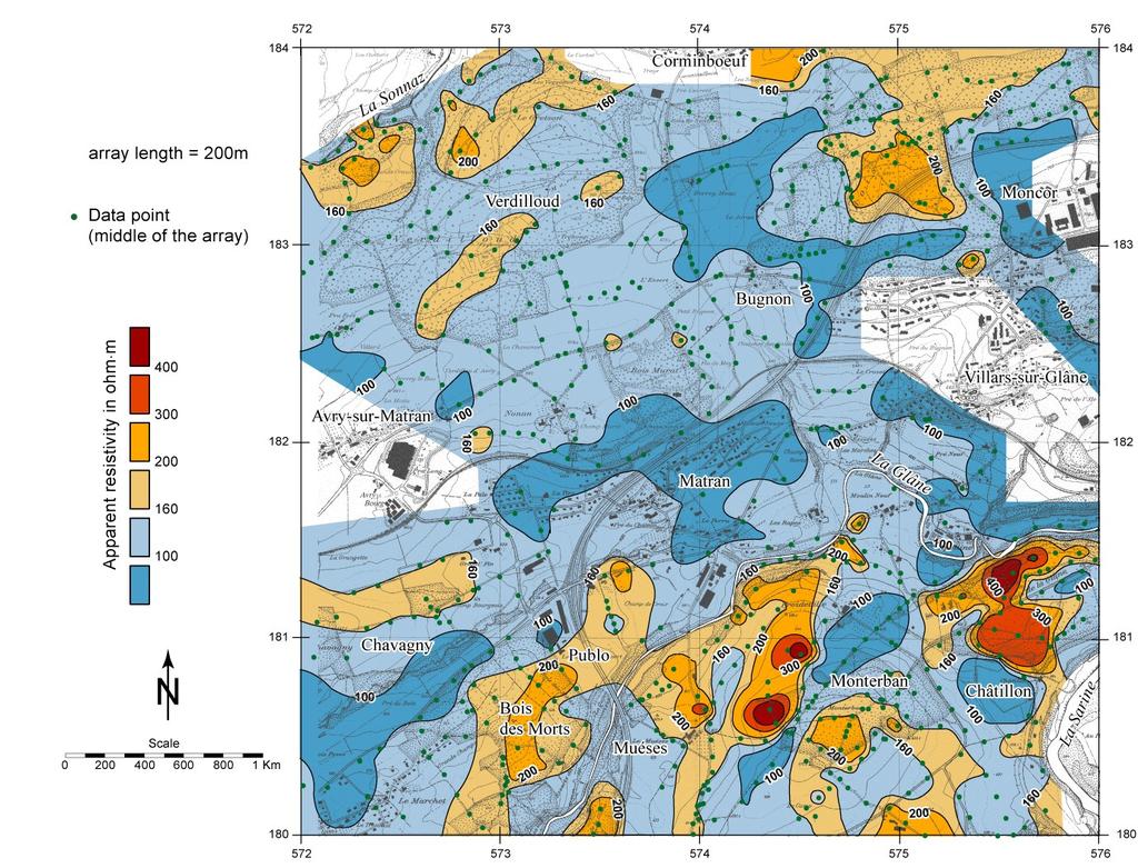
17 Brief Geological Outline
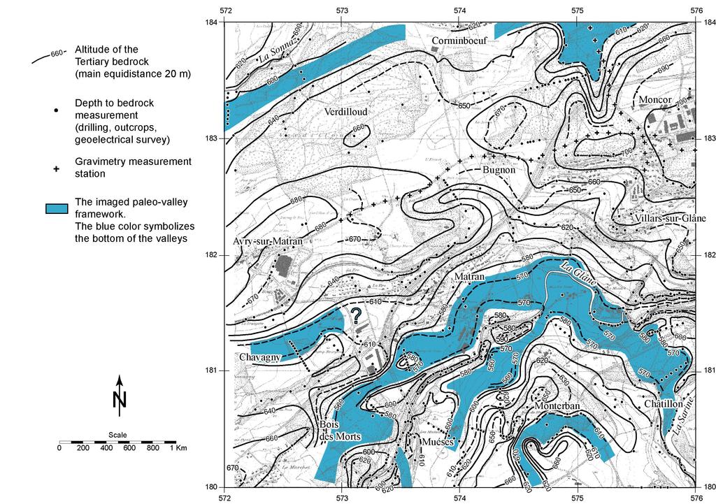
18 Paleo-valleys
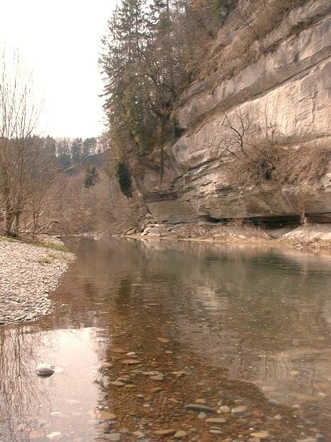
19 Canyons
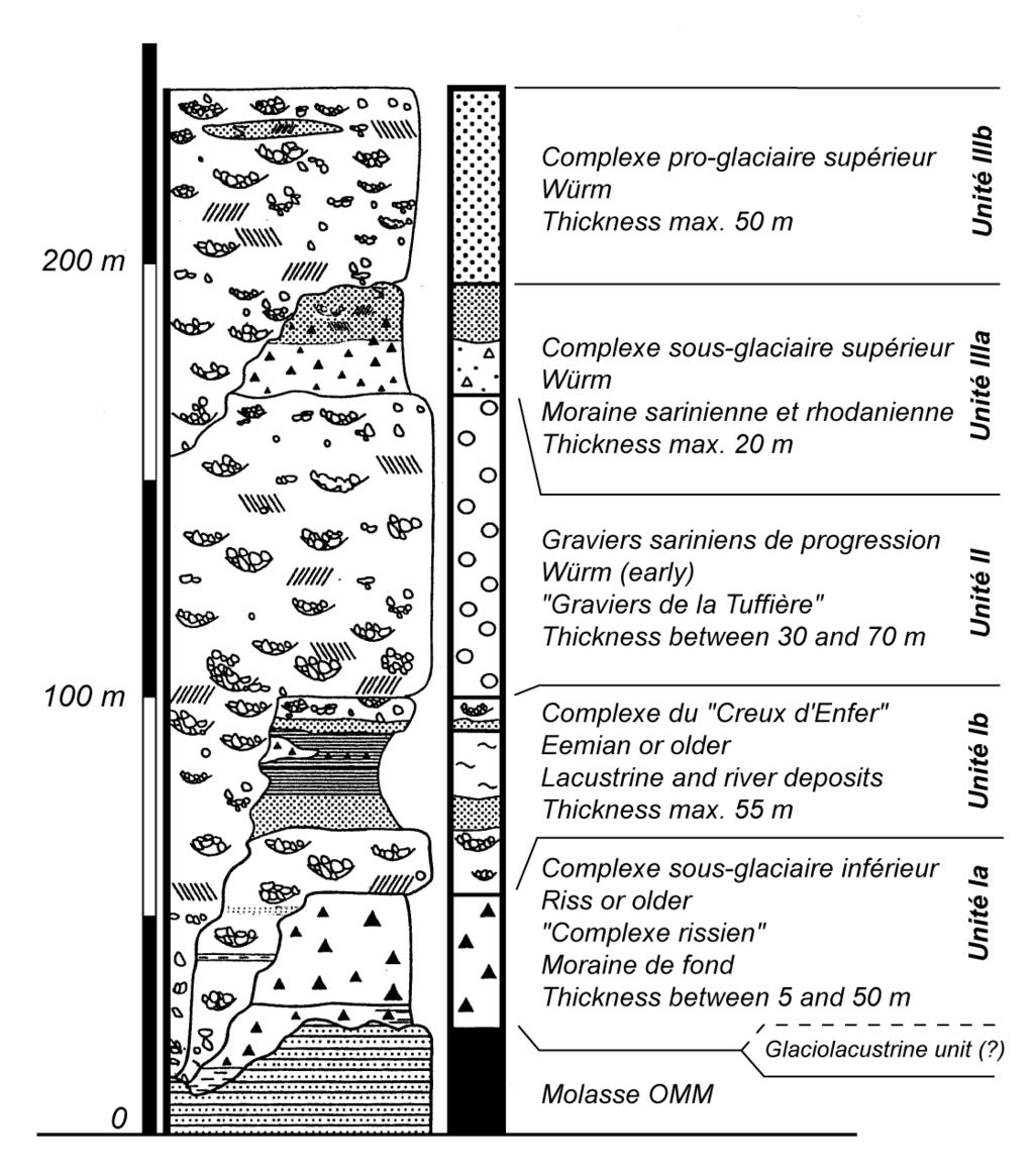
20 Stratigraphy
21 General Methodology Collecting geological, hydrogeological and geotechnical information Parametrical study Resistivity mapping (Schlumberger configuration, array length 200m): 680 data points 35 vertical electrical soundings 20 profiles of 2D resistivity imaging Bedrock topography modelling
22 The Lithology Resistivity Quaternary Post glacial sediments Moraine (with clay) Gravel (with water) Gravel (dry) Sand «Complexe rissien» : : : : : : ohm.m ohm.m ohm.m ohm.m ohm.m ohm.m Tertiary Molasse (bedrock) : ohm.m

23 Available Information
24 Resistivity Mapping

25 S1 S2 S3 S4

26 2D Resistivity Imaging P1

27 2D Resistivity Imaging P3 P4 P2

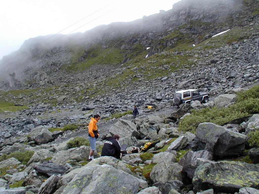
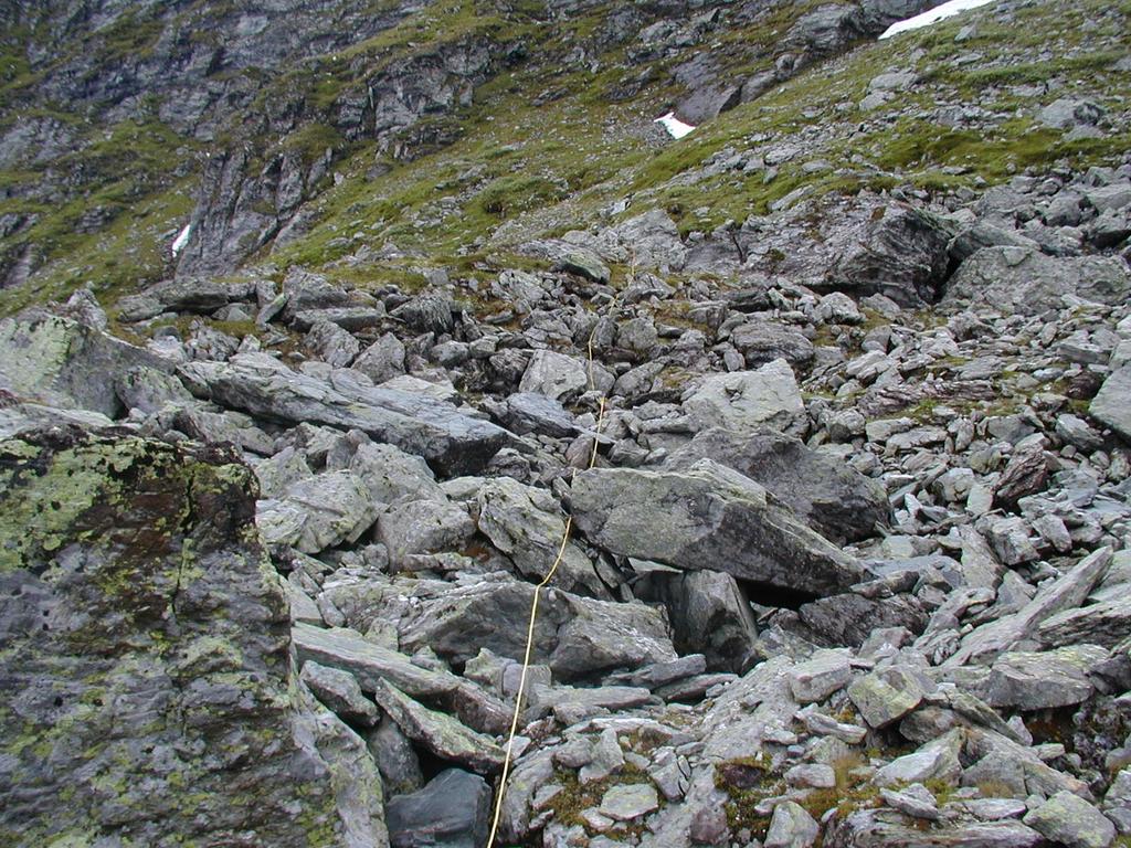
28 2D Resistivity Imaging P6 P5
29
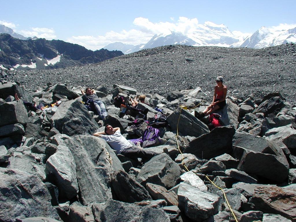
30 Hydrogeological Implications The paleo-valley framework is located in urban and industrial areas Clear connexions between the main paleo-valleys and the springs Clear connexions between the main paleo-valleys and the actual rivers The paleo-valley infilling can be connected with the surface or protected by the moraine The resistivity of the gravel infilling ranges from 200 to 500 ohm.m Pollutant migration risk from the surface to the rivers is plausible
31 Conclusions Resistivity methods give a general overview on the paleo-valley framework Limitations of the method: lateral effects, loss of resolution at depth, resistivity contrast Good correlation between the geoelectrical information and the borehole data for the bedrock altitude Further investigations (e.g. high resolution seismics) can be conducted following the resistivity survey results The paleo-valleys do not continue to the North

32 Case History 2: 2D Electrical Resistivity Imaging in Mountain Permafrost Studies Source: Marescot et al., Near Surface Geophysics 2003
33 What is permafrost? Lithological material with a temperature below 0 C during at least one whole year. What is a rock glacier? A mass of blocks cemented with ice. The velocity of an active rock glacier can reach a few centimetres per year. A schematic lithology of a rock glacier:
 Constructions are endangered (ski resort buildings, cable cars poles, roads ) Ways to study permafrost")
34 A global warming process could partially thaw permafrost. Potentiality and magnitude of slope instabilities are increased (landslides, mud flows) Constructions are endangered (ski resort buildings, cable cars poles, roads ) Ways to study permafrost Geomorphology BTS (Bottom Temperature of Snow cover) Radiometry Geophysics (refraction seismics, DC resistivity, gravimetry, GPR ) Drilling

35 Objectives of resistivity surveys Distribution of permafrost (mapping, thickness). Characterization of ice content in permafrost. Monitoring. Difficulties Significant topographic variations. The surface layer consists of large blocks with air voids.

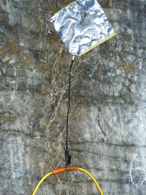
36 Methodology Long (> 1 m) steal stakes Sponges with salt water Acquisition characteristics Contact resistance: about Ohm Injected current: about 2 to 5 ma
37 The research sites location
38
39

40 A dangerous job
 MF3 La Chaux glacier Aget glacier Little Ice Age (1300 to")
41 The Mont Fort survey MF4 La Chaux pass (2940 m a.s.l.) MF3 La Chaux glacier Aget glacier Little Ice Age (1300 to 1850) MF1 MF2
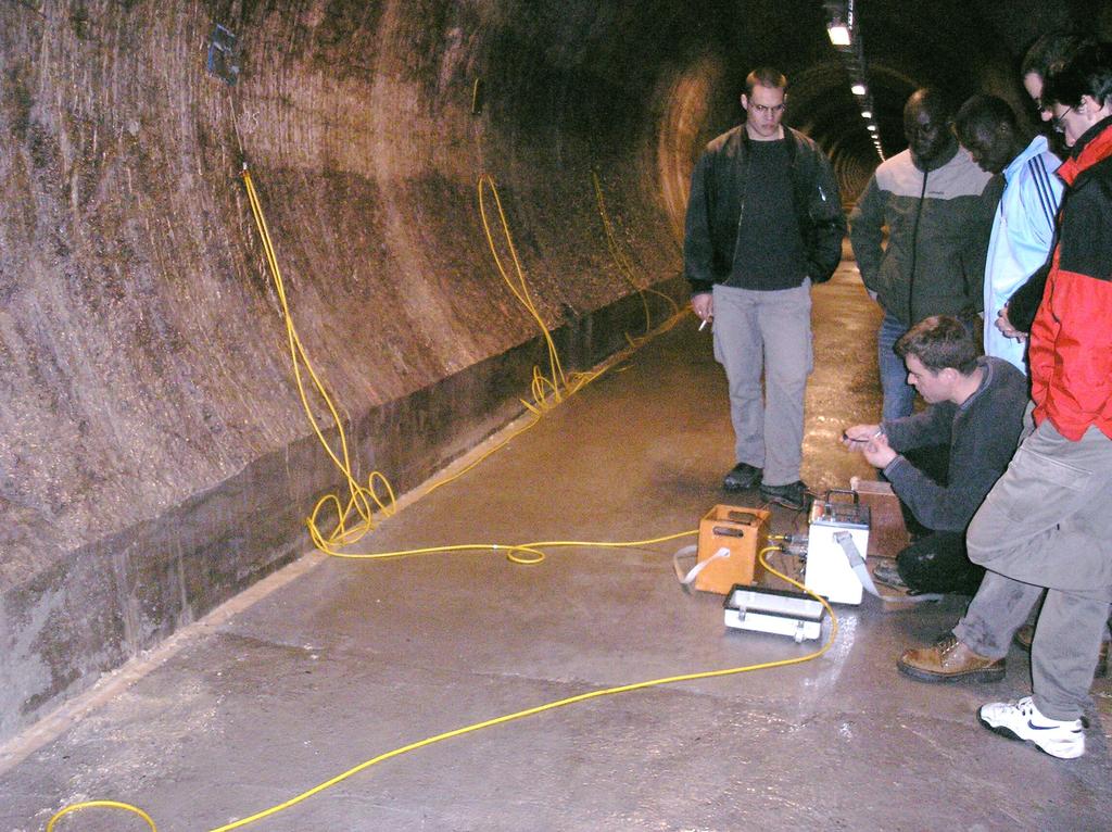
 MF4 La Chaux")
42 La Chaux pass (2940 m a.s.l.) MF4 La Chaux glacier

43 La Chaux glacier La Chaux pass (2940 m a.s.l.)
 Aget glacier La Chaux pass")
44 Mont Fort (3329 m a.s.l.) Aget glacier La Chaux pass (2940 m a.s.l.)

45 Aget glacier proglacial margin
46 MF2
47 MF4 Wenner-Schlumberger array, unit electrode spacing 5 m, 4472 data points, iteration 3, RMS error 8.9% Raw data set The same set without the bad data
48 Aget glacier progress during Little Ice Age

49 Field Example 1: Resistive Structures Source: Marescot et al, 2003
50 Conclusion Effectiveness of 2D resistivity imaging is proven despite unfavourable contact resistance due to the presence of large surface blocks with voids. Penetration depth is low under the frozen material! This method provides information on: The distribution (extent, +/-thickness) of ice in the rock glacier. The ice content in soil: unfrozen scree with voids: 30 to 200 Kohm.m frozen-water in interstices: 10 to 500 Kohm.m buried dead glacier ice: 100 to 2000 Kohm.m The evolution of ice in the future (monitoring).

51 Case History 3: Permanent 3D Rainfall Infiltration Monitoring in Soils Source: N. Denchik, University of Lausanne
52

53
 1 slot = 12 bits Current: 20 ma Positive/negative cycles")
54 Loggers: Squirrel 1000 ( slots) Squirrel 1200 ( slots) 1 slot = 12 bits Current: 20 ma Positive/negative cycles 5 s
55 Measurement procedure

56 Joint inversion


57 Analytic General Geometrical Factor ρ app = G R G= ρ app R = ρ0 R0 4π AM AN BM BN A M A N B M B N G= ρ0 R0 Source: Marescot et al., Journal of Applied Geophysics 2006


58 Source: S. Palma Lopes, LCPC

59 Water Content Calibration ρ app R = ρ0 R0
60 Conclusions The resistivity method is a effective technique for water infiltration monitoring Permanent instrumentation can be easily installed in the field Need for effective 3D joint inversion technique Calibration of water content possible using the General Geometrical Factor approach

61 Final Comments Resistivity imaging is: Cost-effective technique: permanent electrodes in the field Adapted to monitor spatial and temporal water variations Multi scale technique: large scale geophysics to NDT Possible developments: Intensive research in 3D inversion for large models Appraisal part of the problem
62
CHARACTERIZATION OF SOIL PROFILE OF DHAKA CITY USING ELECTRICAL RESISTIVITY TOMOGRAPHY (ERT)
") CHARACTERIZATION OF SOIL PROFILE OF DHAKA CITY USING ELECTRICAL RESISTIVITY TOMOGRAPHY (ERT) Mehedi Ahmed ANSARY 1, B.S. Pushpendue BISWAS 2 and Abul KHAIR 3 1 Professor, Department of Civil Engineering
CHARACTERIZATION OF SOIL PROFILE OF DHAKA CITY USING ELECTRICAL RESISTIVITY TOMOGRAPHY (ERT) Mehedi Ahmed ANSARY 1, B.S. Pushpendue BISWAS 2 and Abul KHAIR 3 1 Professor, Department of Civil Engineering
Electrical Surveying (part A)
") Electrical Surveying (part A) Dr. Laurent Marescot Course given at the University of Fribourg (2009) Contact: laurent@tomoquest.com www.tomoquest.com 1 Introduction Electrical surveying Resistivity method
Electrical Surveying (part A) Dr. Laurent Marescot Course given at the University of Fribourg (2009) Contact: laurent@tomoquest.com www.tomoquest.com 1 Introduction Electrical surveying Resistivity method
Permafrost monitoring at Mölltaler Glacier and Magnetköpfl
 Permafrost monitoring at Mölltaler Glacier and Magnetköpfl DAVID OTTOWITZ 1, BIRGIT JOCHUM 1, ROBERT SUPPER 1, ALEXANDER RÖMER 1, STEFAN PFEILER 1 and MARKUS KEUSCHNIG 2, 3 1 Department of Geophysics,
APPLICATION OF ELECTRICAL RESISTIVITY TOMOGRAPHY FOR SAND UNDERWATER EXTRACTION
 International Scientific Conference GEOBALCANICA 2018 APPLICATION OF ELECTRICAL RESISTIVITY TOMOGRAPHY FOR SAND UNDERWATER EXTRACTION Maya Grigorova Ivaylo Koprev University of Mining and Geology St. Ivan
Introduction. Electrical surveying. Resistivity method Induced polarization method (IP) Self-potential (SP) method
 Self-potential (SP) method") Introduction Electrical surveying Resistivity method Induced polarization method (IP) Self-potential (SP) method Higher frequency methods (electromagnetic surveys): Electromagnetic induction methods Ground
Introduction Electrical surveying Resistivity method Induced polarization method (IP) Self-potential (SP) method Higher frequency methods (electromagnetic surveys): Electromagnetic induction methods Ground
LECTURE 10. Module 3 : Field Tests in Rock 3.6 GEOPHYSICAL INVESTIGATION
 LECTURE 10 3.6 GEOPHYSICAL INVESTIGATION In geophysical methods of site investigation, the application of the principles of physics are used to the study of the ground. The soil/rock have different characteristics
MOUNT POLLEY MINING CORPORATION TECHNICAL REPORT ON MULTI-ELECTRODE RESISTIVITY AND SEISMIC REFRACTION SURVEYS MOUNT POLLEY TAILINGS DAM PROJECT
 MOUNT PLEY MINING CORPORATION TECHNICAL REPORT ON MULTI-ELECTRODE RESISTIVITY AND SEISMIC REFRACTION SURVEYS MOUNT PLEY TAILINGS DAM PROJECT LIKELY, B.C. by Claudia Krumbiegel, M.Sc. Cliff Candy, P.Geo.
RESISTIVITY IMAGING AND BOREHOLE INVESTIGATION OF THE BANTING AREA AQUIFER, SELANGOR, MALAYSIA. A.N. Ibrahim Z.Z.T. Harith M.N.M.
 JOURNAL OF ENVIRONMENTAL HYDROLOGY The Electronic Journal of the International Association for Environmental Hydrology On the World Wide Web at http://www.hydroweb.com VOLUME 11 2003 RESISTIVITY IMAGING
Groundwater Sustainability at Wadi Al Bih Dam, Ras El Khaimah, United Arab Emirates (UAE) using Geophysical methods
 using Geophysical methods") Groundwater Sustainability at Wadi Al Bih Dam, Ras El Khaimah, United Arab Emirates (UAE) using Geophysical methods Ahmed Murad, Amir Gabr, Saber Mahmoud, Hasan Arman & Abdulla Al Dhuhoori Geology Department
Groundwater Sustainability at Wadi Al Bih Dam, Ras El Khaimah, United Arab Emirates (UAE) using Geophysical methods Ahmed Murad, Amir Gabr, Saber Mahmoud, Hasan Arman & Abdulla Al Dhuhoori Geology Department
Electrical Resistivity Survey for Delineating Seawater Intrusion in a Coastal Aquifer
 Electrical Resistivity Survey for Delineating Seawater Intrusion in a Coastal Aquifer Sung-Ho Song*, Gyu-Sang Lee*, Jin-Sung Kim*, Baekuk Seong*, Young-gyu Kim*, Myung-Ha Woo* and Namsik Park** Abstract
Groundwater Level Monitoring of the Quaternary Aquifer at Al Ain City, United Arab Emirates (UAE) using Geophysical Methods
 using Geophysical Methods") Groundwater Level Monitoring of the Quaternary Aquifer at Al Ain City, United Arab Emirates (UAE) using Geophysical Methods Ahmed Murad & Amir Gabr Geology Department UAE University Outlines Introduction
Groundwater Level Monitoring of the Quaternary Aquifer at Al Ain City, United Arab Emirates (UAE) using Geophysical Methods Ahmed Murad & Amir Gabr Geology Department UAE University Outlines Introduction
Surface and borehole electrical resistivity tomography
 Surface and borehole electrical resistivity tomography Laurent Marescot laurent@tomoquest.com Introduction Surface electrical resistivity surveying is based on the principle that the distribution of electrical
DOWN-HOLE SEISMIC SURVEY AND VERTICAL ELECTRIC SOUNDINGS RABASKA PROJECT, LÉVIS, QUÉBEC. Presented to :
 DOWN-HOLE SEISMIC SURVEY AND VERTICAL ELECTRIC SOUNDINGS RABASKA PROJECT, LÉVIS, QUÉBEC Presented to : TERRATECH 455, René-Lévesque Blvd. West Montreal, Québec HZ 1Z3 Presented by : GEOPHYSICS GPR INTERNATIONAL
Azimuthal Resistivity to Characterize Fractures in a Glacial Till. Mark Boris, University of Saskatchewan Jim Merriam, University of Saskatchewan
 Azimuthal Resistivity to Characterize Fractures in a Glacial Till Mark Boris, University of Saskatchewan Jim Merriam, University of Saskatchewan Abstract Azimuthal resistivity was used to characterize
Geological Mapping using Geophysics
 Geological Mapping using Geophysics Pugin, A.J.M. and T.H. Larson Illinois State Geological Survey, 615 E Peabody Dr., Champaign, IL 61820; E-mail: A.J.M. Pugin at pugin@isgs.uiuc.edu Mapping Techniques.
Resistivity & IP methods
 International PhD Course in HYDROGEOPHYSICS Resistivity & IP methods Andrew Binley Lancaster University Overview We have demonstrated links between hydrological and geophysical properties and show the
ambiguity in earth sciences IESO Geophysics Section Eddy hartantyo, Lab Geofisika FMIPA UGM
 ambiguity in earth sciences IESO Geophysics Section Eddy hartantyo, Lab Geofisika FMIPA UGM Pelatihan Tahap II IESO Teknik Geologi UGM Februari 2009 1 Introduction Photos from http://www.eegs.org/whatis/
INTEGRATION OF BOREHOLE INFORMATION AND RESISTIVITY DATA FOR AQUIFER VULNERABILITY
 INTEGRATION OF BOREHOLE INFORMATION AND RESISTIVITY DATA FOR AQUIFER VULNERABILITY ANDERS V. CHRISTIANSEN 1, ESBEN AUKEN 1 AND KURT SØRENSEN 1 1 HydroGeophysics Group, Aarhus University, Finlandsgade 8,
Geophysics for Environmental and Geotechnical Applications
 Geophysics for Environmental and Geotechnical Applications Dr. Katherine Grote University of Wisconsin Eau Claire Why Use Geophysics? Improve the quality of site characterization (higher resolution and
DETECTION OF GROUNDWATER POLLUTION USING RESISTIVITY IMAGING AT SERI PETALING LANDFILL, MALAYSIA
 JOURNAL OF ENVIRONMENTAL HYDROLOGY The Electronic Journal of the International Association for Environmental Hydrology On the World Wide Web at http://www.hydroweb.com VOLUME 8 2000 DETECTION OF GROUNDWATER
Hamed Aber 1 : Islamic Azad University, Science and Research branch, Tehran, Iran. Mir Sattar Meshin chi asl 2 :
 Present a Proper Pattern for Choose Best Electrode Array Based on Geological Structure Investigating in Geoelectrical Tomography, in order to Get the Highest Resolution Image of the Subsurface Hamed Aber
CONTENTS 1. INTRODUCTION. 2. THE D.C. RESISTIVITY METHOD 2.1 Equipment 2.2 Survey Procedure 2.3 Data Reduction
 (i) CONTENTS 1. INTRODUCTION page 1 2. THE D.C. RESISTIVITY METHOD 2.1 Equipment 2.2 Survey Procedure 2.3 Data Reduction 3 3 3 3 3. GEOPHYSICAL RESULTS 3.1 General 3.2 Discussion 4 4 4 4. LIMITATIONS 5
1. Resistivity of rocks
 RESISTIVITY 1) Resistivity of rocks 2) General principles of resistivity surveying 3) Field procedures, interpretation and examples 4) Summary and conclusions INDUCED POLARIZATION 1) General principles
A Case Study of High-Resolution Gravity and Wenner-Schlumberger Resistivity for Geotechnical Engineering: An Example from North Jordan
 Research Journal of Applied Sciences, Engineering and Technology 5(4): 1377-1382-, 2013 ISSN: 2040-7459; e-issn: 2040-7467 Maxwell Scientific Organization, 2013 Submitted: July 09, 2012 Accepted: August
INTEGRATED INVESTIGATION TO LOCATE A WASTE DISPOSAL AREA
 INTEGRATED INVESTIGATION TO LOCATE A WASTE DISPOSAL AREA 1 FOR OIL DRILLING PRODUCTS G. APOSTOLOPOULOS 2, K. PAVLOPOULOS 3, C. ANTONIADES 4, I. LOUIS 5 and C. VLACHOU 4 Nestoros 1, 17564 P.Faliron, Athens,
Geophysical techniques for investigating shallow and deep landslides: results in the framework of PREVIEW project (FP6 UE)
") Geophysical techniques for investigating shallow and deep landslides: results in the framework of PREVIEW project (FP6 UE) Perrone, A; Piscitelli, S; Lampenna, V; Lamporte, A; Giocolli, A; Dahlin, Torleif
Geophysical techniques for investigating shallow and deep landslides: results in the framework of PREVIEW project (FP6 UE) Perrone, A; Piscitelli, S; Lampenna, V; Lamporte, A; Giocolli, A; Dahlin, Torleif
KARST MAPPING WITH GEOPHYSICS AT MYSTERY CAVE STATE PARK, MINNESOTA
 KARST MAPPING WITH GEOPHYSICS AT MYSTERY CAVE STATE PARK, MINNESOTA By Todd A. Petersen and James A. Berg Geophysics Program Ground Water and Climatology Section DNR Waters June 2001 1.0 Summary A new
ENVIRONMENTAL AND ENGINEERING GEOPHYSICS
 ENVIRONMENTAL AND ENGINEERING GEOPHYSICS Environmental Engineering MSc 08/09 nd semester COURSE COMMUNICATION DOCUMENT University of Miskolc Faculty of Earth Science and Engineering Institute of Geophysics
GLG 471; MICHIGAN STATE UNIVERSITY INSTRUCTOR R.L. VAN DAM PROJECT: ELECTRICAL RESISTIVITY
 GLG 471; MICHIGAN STATE UNIVERSITY INSTRUCTOR R.L. VAN DAM PROJECT: ELECTRICAL RESISTIVITY General information: This is a group (2-3 students) project requiring lab-, computer-, and fieldwork. Work will
3D Modelling of the Uppsala Esker
 3D Modelling of the Uppsala Esker Eva Jirner (SGU) Duncan McConnachie (WSP Sweden) 2017-05-31 ISO/TC211 Geographic Information/Geomatics A collabrative effort Orientation 3 Background Uppsala municiaplity
Geophysics Course Interpreting DC Resistivity Data
 NORAD supported project in MRRD covering Capacity Building and Institutional Cooperation in the field of Hydrogeology for Faryab Province Afghanistan Geophysics Course Interpreting DC Resistivity Data
Characterisation of potentially unstable mountain permafrost A multidisciplinary approach
 Characterisation of potentially unstable mountain permafrost A multidisciplinary approach Permafrost, Phillips, Springman & Arenson (eds) 2003 Swets & Zeitlinger, Lisse, ISBN 90 5809 582 7 H.R. Maurer,
Case Study: University of Connecticut (UConn) Landfill
 Landfill") Case Study: University of Connecticut (UConn) Landfill Problem Statement:» Locate disposal trenches» Identify geologic features and distinguish them from leachate and locate preferential pathways in fractured
Case Study: University of Connecticut (UConn) Landfill Problem Statement:» Locate disposal trenches» Identify geologic features and distinguish them from leachate and locate preferential pathways in fractured
The TEMPS project: The evolution of mountain permafrost in Switzerland
 The TEMPS project: The evolution of mountain permafrost in Switzerland Christian Hauck, Reynald Delaloye, Isabelle Gärtner-Roer, Andreas Hasler, Christin Hilbich, Martin Hoelzle, Robert Kenner, Sven Kotlarski,
DATA ACQUISITION METHODS FOR GROUNDWATER INVESTIGATION AND THE SITING OF WATER SUPPLY WELLS
 DATA ACQUISITION METHODS FOR GROUNDWATER INVESTIGATION AND THE SITING OF WATER SUPPLY WELLS M.B.J. Foster Tetra Tech EM Inc., San Francisco, CA, USA Keywords: Groundwater, water wells, drilled wells, geophysical
ELECTRICAL RESISTIVITY TOMOGRAPHY
 NOTIO Association Clay Technological Centre C/ Río Cabriel s/n 45007 Toledo Tel.: 925 24 11 62 info@notio.es www.notio.es Page 1 / 7 SUMMARY 1. PHYSICAL FUNDAMENTALS OF THE... 3 1.1. ELECTRICAL BEHAVIOR
Advanced processing and inversion of two AEM datasets for 3D geological modelling: the case study of Spiritwood Valley Aquifer
 Advanced processing and inversion of two AEM datasets for 3D geological modelling: the case study of Spiritwood Valley Aquifer Vincenzo Sapia, INGV, Rome, Italy Vincenzo.sapia@ingv.it Andrea Viezzoli,
Scholars Research Library
 Available online at www.scholarsresearchlibrary.com Scholars Research Library Archives of Physics Research, 2010, 1 (2):37-45 (http://scholarsresearchlibrary.com/archive.html) ISSN 0976-0970 2-D Resistivity
2-D Resistivity Study: The Horizontal Resolution Improvement by Introducing the Enhancing Horizontal Resolution (EHR) Technique
 Technique") Open Journal of Geology, 213, 3, 1-6 doi:1.4236/ojg.213.32b1 Published Online April 213 (http://www.scirp.org/journal/ojg) 2-D Resistivity Study: The Horizontal Resolution Improvement by Introducing the
Open Journal of Geology, 213, 3, 1-6 doi:1.4236/ojg.213.32b1 Published Online April 213 (http://www.scirp.org/journal/ojg) 2-D Resistivity Study: The Horizontal Resolution Improvement by Introducing the
B7 Applications of DC resistivity exploration
 B7 Applications of DC resistivity exploration Modern DC resistivity surveys collect data for generating a 2-D or 3-D geoelectric model of the Earth. A simple 1-D analysis does not often yield results that
Appendix B: Geophysical Data (Thesis Appendix, 2013)
") Utah State University From the SelectedWorks of David J Richey 2013 Appendix B: Geophysical Data (Thesis Appendix, 2013) David J Richey, Utah State University Available at: https://works.bepress.com/david_richey/2/
Utah State University From the SelectedWorks of David J Richey 2013 Appendix B: Geophysical Data (Thesis Appendix, 2013) David J Richey, Utah State University Available at: https://works.bepress.com/david_richey/2/
Analysis of electrical resistivity data for the determination of aquifer depth at Sapele RD in Benin city
 Available online at www.pelagiaresearchlibrary.com Advances in Applied Science Research, 203, 4(6):268-276 ISSN: 0976-860 CODEN (USA): AASRFC Analysis of electrical resistivity data for the determination
Delineating The Subsurface Structures Using Electrical Resistivity Sounding In Some Part Of Willeton, Perth, Western Australia
 Delineating The Subsurface Structures Using Electrical Resistivity Sounding In Some Part Of Willeton, Perth, Western Australia Okan Evans Onojasun, Emudianughe Juliet Abstract: Geophysical survey using
Permafrost monitoring using time-lapse resistivity tomography
 Permafrost monitoring using time-lapse resistivity tomography Permafrost, Phillips, Springman & Arenson (eds) 2003 Swets & Zeitlinger, Lisse, ISBN 90 5809 582 7 C. Hauck 1 Graduiertenkolleg Natural Disasters
Need of Proper Development in Hilly Urban Areas to Avoid
 Need of Proper Development in Hilly Urban Areas to Avoid Landslide Hazard Dr. Arvind Phukan, P.E. Cosultant/Former Professor of Civil Engineering University of Alaska, Anchorage, USA RI District Governor
Geoelectrical characterization for liquefaction at coastal zone in South Aceh
 Geoelectrical characterization for liquefaction at coastal zone in South Aceh Muhammad Syukri Laboratory of Geophysics, Department of Physics, Faculty of Mathematic and Sciences, Syiah Kuala University.
Tu 23P1 06 Mapping Possible Flowpaths of Contaminants through Surface and Cross-borehole Spectral Timedomain Induced Polarization
 Tu 23P1 06 Mapping Possible Flowpaths of Contaminants through Surface and Cross-borehole Spectral Timedomain Induced Polarization T. Bording* (Aarhus University), G. Fiandaca (Aarhus University), P.K.
Geophysics Course Introduction to DC Resistivity
 NORAD supported project in MRRD covering Capacity Building and Institutional Cooperation in the field of Hydrogeology for Faryab Province Afghanistan Geophysics Course Introduction to DC Resistivity By
Geophysical Investigation of the Old Gaborone Dumpsite, Botswana SHEMANG, E M; MOLWALEFHE, L; CHAOKA, TR; MOSWEU E; NONDO, M
 JASEM ISSN 1119-8362 All rights reserved Full-text Available Online at www.bioline.org.br/ja J. Appl. Sci. Environ. Mgt. September, 2006 Vol. 10 (3) 87-92 Geophysical Investigation of the Old Gaborone
ENCE 3610 Soil Mechanics. Site Exploration and Characterisation Field Exploration Methods
 ENCE 3610 Soil Mechanics Site Exploration and Characterisation Field Exploration Methods Geotechnical Involvement in Project Phases Planning Design Alternatives Preparation of Detailed Plans Final Design
Application of geophysical results to designing bridge. over a large fault
 Application of geophysical results to designing bridge over a large fault Ho-Joon Chung 1, Jung-Ho Kim 2, Keun-Pil Park 2, Hyoung-Seok Kwon 1, Ho-Sik Choi 3, Ki-Seog Kim 4, Jong-Soo Kim 5 1 Manager, HeeSong
GG101 Lecture 22: Mass Wasting. Soil, debris, sediment, and broken rock is called regolith.
 GG101 Lecture 22: Mass Wasting Mass Wasting is the movement of rock and soil down a slope due to the force of gravity. Soil, debris, sediment, and broken rock is called regolith. Mass wasting creates broad
Geophysical Exploration in Water Resources Assessment. John Mundell, P.E., L.P.G., P.G. Ryan Brumbaugh, L.P.G. Mundell & Associates, Inc.
 Geophysical Exploration in Water Resources Assessment John Mundell, P.E., L.P.G., P.G. Ryan Brumbaugh, L.P.G. Mundell & Associates, Inc. Presentation Objective Introduce the use of geophysical survey methods
Measuring integral soil moisture variations using a geoelectrical resistivity meter
 Measuring integral soil moisture variations using a geoelectrical resistivity meter Thomas Klügel 1, Günter Harnisch 2 & Martina Harnisch 2 1 Bundesamt für Kartographie und Geodäsie, Fundamentalstation
Geoelectricity. ieso 2010
 Geoelectricity ieso 2010 1 RESISTIVITY SURVEY AT VENETO VILLA GRITTI AT THE TOWN OF TREVISO (VENETO REGION) The survey was carried out to verify the underground presence of the fondations of a rustic building.
GEOELECTRICAL INVESTIGATION OF GROUNDWATER CONDITION IN OLEH, NIGERIA
 www.arpapress.com/volumes/vol15issue1/ijrras_15_1_14.pdf GEOELECTRICAL INVESTIGATION OF GROUNDWATER CONDITION IN OLEH, NIGERIA O. Anomohanran Physics Department, Delta State University, Abraka, Delta State,
Aspects of Geophysical Exploration for Groundwater Using Vertical Electrical Sounding (VES) in Parts of University of Benin, Benin City, Edo State
 in Parts of University of Benin, Benin City, Edo State") JASEM ISSN 1119-8362 All rights reserved Full-text Available Online at wwwajolinfo and wwwbiolineorgbr/ja J Appl Sci Environ Manage March 2014 Vol 18 (1) 19-25 Aspects of Geophysical Exploration for Groundwater
JASEM ISSN 1119-8362 All rights reserved Full-text Available Online at wwwajolinfo and wwwbiolineorgbr/ja J Appl Sci Environ Manage March 2014 Vol 18 (1) 19-25 Aspects of Geophysical Exploration for Groundwater
GEOSPATIAL ANALYSIS OF GLACIAL DYNAMICS OF SHIGAR AND SHAYOK BASINS. Syed Naseem Abbas Gilany 1
 GEOSPATIAL ANALYSIS OF GLACIAL DYNAMICS OF SHIGAR AND SHAYOK BASINS 1 OUTLINE Introduction Problem Statement / Rationale Objectives Material and Methods Study Area Datasets Required Data Analysis / Assessment
FUNDAMENTALS OF ENGINEERING GEOLOGY
 FUNDAMENTALS OF ENGINEERING GEOLOGY Prof. Dr. HUSSEIN HAMEED KARIM Building and Construction Engineering Department 2012 Preface The impulse to write this book stemmed from a course of geology given by
Geophysical Investigation of Ground Water Using Vertical Electrical Sounding and Seismic Refraction Methods
 International Journal of Petroleum and Petrochemical Engineering (IJPPE) Volume 2, Issue 1, 2016, PP 6-11 ISSN 2454-7980 (Online) www.arcjournals.org Geophysical Investigation of Ground Water Using Vertical
Site Characterization & Hydrogeophysics
 Site Characterization & Hydrogeophysics (Source: Matthew Becker, California State University) Site Characterization Definition: quantitative description of the hydraulic, geologic, and chemical properties
Abdul Rahim Samsudin, Bahaa-eldin Elwali A.Rahim, Wan Zuhairi Wan Yaacob & Umar Hamzah
 Journal of Spatial Hydrology Vol.6, No.2 Fall 2006 Mapping of contamination plumes at municipal solid waste disposal sites using geoelectric imaging technique: Case studies in Malaysia Abdul Rahim Samsudin,
A scale/resolution problem
 Near Surface 2005 September 4-7, 2005, Palermo Italy WORKSHOP on Hydrogeophysics a tool for sustainable use of groundwater resources Integrated Seismic and GPR characterization of fractured rocks Pipan,
2-D Resistivity Imaging in Taiping, Perak, Malaysia
 2-D Resistivity Imaging in Taiping, Perak, Malaysia A. I. Rosli *,1, M. A. Mohamed Zawawi 1, H. Juahir 2, N. Z. Karim 3 and N. F. Yusof 1 1 Department of Biological and Agricultural Engineering, Faculty
High Resolution Time-domain Induced Polarization Tomography with Merging Data Levels by Two Different Optimized Arrays for Slope Monitoring Study
 High Resolution Time-domain Induced Polarization Tomography with Merging Data Levels by Two Different Optimized Arrays for Slope Monitoring Study Andy A. Bery Geophysics Section, School of Physics, Universiti
Electrical prospecting involves detection of surface effects produced by electrical current flow in the ground.
 Electrical Surveys in Geophysics Electrical prospecting involves detection of surface effects produced by electrical current flow in the ground. Electrical resistivity method Induced polarization (IP)
GEOTECHNICAL ENGINEERING INVESTIGATION HANDBOOK Second Edition
 GEOTECHNICAL ENGINEERING INVESTIGATION HANDBOOK Second Edition Roy E. Hunt Taylor & Francis Taylor & Francis Croup Boca Raton London New York Singapore A CRC title, part of the Taylor & Francis imprint,
WATERCOURSE HARNESSING BANK EROSION AND CONSOLIDATION
 GUVERNUL MINISTERUL POSDRU MUNCII, FAMILIEI ŞI WATERCOURSE HARNESSING BANK EROSION AND CONSOLIDATION PhD. student: ALUPOAE Daniel Gheorghe Asachi Technical University of Iasi, Faculty of Civil Engineering
Basin Analysis Applied to Modelling Buried Valleys in the Great Lakes Basin
 EARTH SCIENCES SECTOR GENERAL INFORMATION PRODUCT 35 Basin Analysis Applied to Modelling Buried Valleys in the Great Lakes Basin Sharpe, D R; Russell, H A J 2004 Originally released as: Basin Analysis
2-D RESISTIVITY IMAGING SURVEY FOR WATER-SUPPLY TUBE WELLS IN A BASEMENT COMPLEX: A CASE STUDY OF OOU CAMPUS, AGO-IWOYE SW NIGERIA
 2-D RESISTIVITY IMAGING SURVEY FOR WATER-SUPPLY TUBE WELLS IN A BASEMENT COMPLEX: A CASE STUDY OF OOU CAMPUS, AGO-IWOYE SW NIGERIA 1 AYOLABI, Elijah Adebowale. 2 FOLORUNSO, Adetayo Femi. and 3 ARIYO, Stephen
Geophysical mapping and imaging of soil structures: basic overview
 Geophysical mapping and imaging of soil structures: basic overview Stéphane Garambois Landslide team, LGIT, Université Joseph Fourier 3D imaging of the water table (seismic) Geophysical methods 1 Plan
Down-stream process transition (f (q s ) = 1)
 = 1)") Down-stream process transition (f (q s ) = 1) Detachment Limited S d >> S t Transport Limited Channel Gradient (m/m) 10-1 Stochastic Variation { Detachment Limited Equilibrium Slope S d = k sd A -θ d S
Down-stream process transition (f (q s ) = 1) Detachment Limited S d >> S t Transport Limited Channel Gradient (m/m) 10-1 Stochastic Variation { Detachment Limited Equilibrium Slope S d = k sd A -θ d S
Which map shows the stream drainage pattern that most likely formed on the surface of this volcano? A) B)
 B)") 1. When snow cover on the land melts, the water will most likely become surface runoff if the land surface is A) frozen B) porous C) grass covered D) unconsolidated gravel Base your answers to questions
1. When snow cover on the land melts, the water will most likely become surface runoff if the land surface is A) frozen B) porous C) grass covered D) unconsolidated gravel Base your answers to questions
2D Resistivity Imaging Investigation of Solid Waste Landfill Sites in Ikhueniro Municipality, Ikpoba Okha Local Government Area,Edo State, Nigeria.
 2D Resistivity Imaging Investigation of Solid Waste Landfill Sites in Ikhueniro Municipality, Ikpoba Okha Local Government Area,Edo State, Nigeria. Iyoha. A, Akhirevbulu O.E, Amadasun C.V.O and Evboumwan
Seismic Reflection Imaging across the Johnson Ranch, Valley County, Idaho
 Seismic Reflection Imaging across the Johnson Ranch, Valley County, Idaho Report Prepared for the Skyline Corporation Lee M. Liberty Center for Geophysical Investigation of the Shallow Subsurface (CGISS)
DC Resistivity Investigation of Anisotropy and Lateral Effect using Azimuthal Offset Wenner Array. a case Study of the University of Calabar, Nigeria
 DC Resistivity Investigation of Anisotropy and Lateral Effect using Azimuthal Offset Wenner Array. a case Study of the University of Calabar, Nigeria George, A. Michael 1,Abong. A. Agwul 2* 1.Department
2-D GEOELECTRICAL SURVEY FOR THE PRELIMINARY ROUTE OF THE NATURAL GAS PIPELINE INSTALLATION AT ALISTRATI CAVES, N. GREECE 1 INTRODUCTION
 ελτίο της Ελληνικής Γεωλογικής Εταιρίας τοµ. XXXVI, 24 Πρακτικά 1 ου ιεθνούς Συνεδρίου, Θεσ/νίκη Απρίλιος 24 Bulletin of the Geological Society of Greece vol. XXXVI, 24 Proceedings of the 1 th International
Geo-hazard Potential Mapping Using GIS and Artificial Intelligence
 Geo-hazard Potential Mapping Using GIS and Artificial Intelligence Theoretical Background and Uses Case from Namibia Andreas Knobloch 1, Dr Andreas Barth 1, Ellen Dickmayer 1, Israel Hasheela 2, Andreas
June 9, R. D. Cook, P.Eng. Soils Engineer Special Services Western Region PUBLIC WORKS CANADA WESTERN REGION REPORT ON
 PUBLIC WORKS CANADA WESTERN REGION REPORT ON GEOTECHNICAL INVESTIGATION PROPOSED MARTIN RIVER BRIDGE MILE 306.7 MACKENZIE HIGHWAY Submitted by : R. D. Cook, P.Eng. Soils Engineer Special Services Western
Integration of Seismic Refraction and 2D Electrical Resistivity in Locating Geological Contact
 Open Journal of Geology, 2013, 3, 7-12 doi:10.4236/ojg.2013.32b002 Published Online April 2013 (http://www.scirp.org/journal/ojg) Integration of Seismic Refraction and 2D Electrical Resistivity in Locating
FINAL REPORT GEOPHYSICAL INVESTIGATION VILLAGE ALHAMBRA RETENTION POND SITE THE VILLAGES, FLORIDA
 FINAL REPORT GEOPHYSICAL INVESTIGATION VILLAGE ALHAMBRA RETENTION POND SITE THE VILLAGES, FLORIDA Prepared for Andreyev Engineering, Inc. Oxford, FL Prepared by GeoView, Inc. St. Petersburg, FL August
Palaeoscars and landslide prediction using 2D ERI techniques in Ooty area, Nilgiri district, Tamilnadu
 Available online at www.scholarsresearchlibrary.com Archives of Applied Science Research, 2012, 4 (1):262-268 (http://scholarsresearchlibrary.com/archive.html) ISSN 0975-508X CODEN (USA) AASRC9 Palaeoscars
SEISMIC RADAR AND ELECTRICAL TECHNIQUES FOR WASTE DISPOSAL ASSESSMENT. M. Pipan, G. Dal Moro, E. Forte & M. Sugan
 SEISMIC RADAR AND ELECTRICAL TECHNIQUES FOR WASTE DISPOSAL ASSESSMENT M. Pipan, G. Dal Moro, E. Forte & M. Sugan Department of Geological, Environmental and Marine Sciences, University of Trieste Via Weiss,
GLE 594: An introduction to applied geophysics
 GLE 594: An introduction to applied geophysics Electrical Resistivity Methods Fall 2004 Earth Properties and Basic Theory Reading Today : 207-218 Next Lecture : 218-228 1 Introduction Link resistivity
Geophysical Investigation: A Case Study of Basement Complex, Nigeria
 Geophysical Investigation: A Case Study of Basement Complex, Nigeria Adiela U.P 1, Ayodele Moses Oyewole 2 and Omoirabor Omoleomo 3 1 Department of Petroleum Engineering, Nigerian Agip Oil Company, Port
Gotechnical Investigations and Sampling
 Gotechnical Investigations and Sampling Amit Prashant Indian Institute of Technology Gandhinagar Short Course on Geotechnical Investigations for Structural Engineering 12 14 October, 2017 1 Purpose of
Geophysical Surveys for Groundwater Modelling of Coastal Golf Courses
 1 Geophysical Surveys for Groundwater Modelling of Coastal Golf Courses C. RICHARD BATES and RUTH ROBINSON Sedimentary Systems Research Group, University of St. Andrews, St. Andrews, Scotland Abstract
Coal Layer Identification using Electrical Resistivity Imaging Method in Sinjai Area South Sulawesi
 Journal of Physics: Conference Series PAPER OPEN ACCESS Coal Layer Identification using Electrical Resistivity Imaging Method in Sinjai Area South Sulawesi To cite this article: Andi Ilham Samanlangi 2018
Static Corrections for Seismic Reflection Surveys
 Static Corrections for Seismic Reflection Surveys MIKE COX Volume Editors: Series Editor: Eugene F. Scherrer Roland Chen Eugene F. Scherrer Society of Exploration Geophysicists Tulsa, Oklahoma Contents
b Blackwell Science Environmental Geology PRINCIPLES AND PRACTICE
 Environmental Geology PRINCIPLES AND PRACTICE Fred G. Bell Department of Geology and Applied Geology University of Natal, Durban, South Africa b Blackwell Science Preface, ix 1 Introduction, 1 1.1 Planning
Ground-Water Exploration in the Worthington Area of Nobles County: Summary of Seismic Data and Recent Test Drilling Results
 Ground-Water Exploration in the Worthington Area of Nobles County: Summary of Seismic Data and Recent Test Drilling Results Jim Berg and Todd Petersen Geophysicists, DNR Waters January 2000 Table of Contents
GPR AS A COST EFFECTIVE BEDROCK MAPPING TOOL FOR LARGE AREAS. Abstract
 GPR AS A COST EFFECTIVE BEDROCK MAPPING TOOL FOR LARGE AREAS Dr. Jutta L. Hager, Hager GeoScience, Inc., Waltham, MA Mario Carnevale, Hager GeoScience, Inc., Waltham, MA Abstract Hager GeoScience, Inc.
ENVIRONMENTAL GEOSCIENCE UNIFORM SYLLABUS
 ENVIRONMENTAL GEOSCIENCE UNIFORM SYLLABUS The Association of Professional Engineers and Geoscientists of the Province of British Columbia Note: 1. This Syllabus May Be Subject To Change 2. These Courses
IMAGING OF DEEP SINKHOLES USING THE MULTI-ELECTRODE RESISTIVITY IMPLANT TECHNIQUE (MERIT) CASE STUDIES IN FLORIDA
 CASE STUDIES IN FLORIDA") IMAGING OF DEEP SINKHOLES USING THE MULTI-ELECTRODE RESISTIVITY IMPLANT TECHNIQUE (MERIT) CASE STUDIES IN FLORIDA David Harro The G3 Group, 2509 Success Drive, Suite 1, Odessa, FL 33556, david.harro@geo3group.com
IMAGING OF DEEP SINKHOLES USING THE MULTI-ELECTRODE RESISTIVITY IMPLANT TECHNIQUE (MERIT) CASE STUDIES IN FLORIDA David Harro The G3 Group, 2509 Success Drive, Suite 1, Odessa, FL 33556, david.harro@geo3group.com
GEOL4714 Final Exam Fall 2005, C. H. Jones instructor
 GEOL4714 Final Exam Fall 2005 p. 1 GEOL4714 Final Exam Fall 2005, C. H. Jones instructor Name: Student ID #: Feel free to use the back of the sheets for answers needing more space. (1) (10 pts) For each
Michigan s Geology and Groundwater
 Michigan s Geology and Groundwater Ralph J. Haefner Deputy Director U.S. Geological Survey Michigan-Ohio Water Science Center Lansing, Michigan Outline About the USGS Geology 101 Michigan s geology Bedrock
GPR survey and field work summary in Siilinjärvi mine during July 2014
 GEOLOGICAL SURVEY OF FINLAND Groundwater Espoo 21.6.2016 67/2016 GPR survey and field work summary in Siilinjärvi mine during July 2014 Samrit Luoma, Juha Majaniemi, Tiina Kaipainen, and Antti Pasanen
High Resolution Geophysics: A Better View of the Subsurface. By John Jansen, P.G., Ph.D., Aquifer Science and Technology
 High Resolution Geophysics: A Better View of the Subsurface By John Jansen, P.G., Ph.D., Aquifer Science and Technology Geologist Use Only Part of the Information Available To Them Most Geologist rely
Combination of ID laterally constrained inversion and smooth inversion of resistivity data with a priori data from boreholes
 Combination of ID laterally constrained inversion and smooth inversion of resistivity data with a priori data from boreholes Wisén, Roger; Auken, E; Dahlin, Torleif Published in: Near Surface Geophysics
B029 2D and 3D Resistivity Imaging in an Investigation of Boulder Occurrence and Soil Depth in Glacial Till
 B029 2D and 3D Resistivity Imaging in an Investigation of Boulder Occurrence and Soil Depth in Glacial Till R. Wisen* (Lund University), F. Linders (Lund University) & T. Dahlin (Lund University) SUMMARY