Introduction. Electrical surveying. Resistivity method Induced polarization method (IP) Self-potential (SP) method
|
|
|
- Trevor Morrison
- 5 years ago
- Views:
Transcription
1
2 Introduction Electrical surveying Resistivity method Induced polarization method (IP) Self-potential (SP) method Higher frequency methods (electromagnetic surveys): Electromagnetic induction methods Ground penetrating radar (GPR) 2
3 Resistivity method The resistivity method is used in the study of horizontal and vertical discontinuities in the electrical properties (resistivity) of the subsurface 3
4 Application Exploration of bulk mineral deposit (sand, gravel) Exploration of underground water supplies Engineering/construction site investigation Waste sites and pollutant investigations Cavity, karst detection Glaciology, permafrost Geology Archaeological investigations 4
5 Structure of the lecture The next two lectures 1. Resistivity of rocks 2. Equations in resistivity surveying 3. Survey strategies and interpretation 4. Summary of resistivity methods: case histories 5. Conclusions 5
6 1. Resistivity of rocks 6
7 Resistivity and units ρ resistivity in ohm.m (Ωm) σ =1/ ρ conductivity in Siemens per meter (S/m) δ L δr = ρ δ A δ A ρ = δr δ L Resistivity is the physical property which determines the aptitude of this material to be opposed to the passage of the electrical current 7
8 Electronic conductibility The current flows by displacement of electrons. Known as electronic conductibility or metallic because it is a similar conductibility to that of metals. This solid conductibility is really significant only for certain massive mineral deposits. 8
9 Electrolytic conductibility The current is carried by ions. The electrical resistivity of rocks bearing water is controlled mainly by the water which they contain. 9
10 Electrolytic conductibility The resistivity of a rock will depend : on the resistivity of the natural pore water and consequently the quantity of dissolved salts in the electrolyte 1g/liter=1000 ppm on the quantity of electrolyte contained in the unit of rock volume (saturation) on the mode of electrolyte distribution, porosity 10
11 Effect of temperature ρ = t 1+ ρ ( t 18) A rock totally frozen is infinitely resistant and it is impossible to implement resitivity methods (use EM methods) 11
 m cementation factor (depends of the pores shape, of the compaction and varies between 1.3 for unconsolidated sands to 2.")
12 Archie s Law ρ = ρ a φ w m S n ρ resistivity of the rock ρ w resistivity of the fluid (water) Φ porosity S saturation in water a factor which depends of the lithology (varies between 0.6 and 2) m cementation factor (depends of the pores shape, of the compaction and varies between 1.3 for unconsolidated sands to 2.2 for cimented limestone n about 2 for majority of the formations with normal porosities containing water between 20 and 100 %. 12
13 Formation factor F ρ = ρ aφ ρ = ρ w w FS m n S n For sand and sandstones: F 0.62/φ 2.15 For well cemented rocks: F 1/φ 2 13
14 Permeability There is no direct relationship between resistivity and permeability. 14

15 Resistivity of rocks and minerals Air, gas or oil: infinite or very high resistivity! Liquid materials from landfills are generally conductive (<10 ohm.m) 15
16 Effect of clay and graphite Clay has a high ionic exchange capacity, therefore the conductivity of the pore fluid largely increases Archie s Law is not valid if clay is present! Graphite, often associated with pyrite, makes the resistivity decrease 16
17 Summary The conductivity of a rock increases if The quantity of water increases The salinity increases (quantity of ions) The quantity of clay increases The temperature increases 17
18 Current flow in the ground 21
19
20 Two current electrodes 26
21 Potential field between two current electrodes A and B A B 27
22 Potential difference V p1 is the sum of the potential contribution from the current electrodes C 1 and C 2 V P = Iρ / 2πr 1 + ( Iρ / 2πr ) = ( ) 2 Iρ / 2π r1 2 1 r

23 29 Two potential electrodes = + = = = = NB AN MB AM I V NB AN MB AM I V V V NB AN I V MB AM I V MN a N M MN N M π ρ π ρ π ρ π ρ
24 Apparent resistivity In a heterogeneous medium, the measured resistivity is an apparent resistivity, which is a function of the form of the inhomogeneity and of the electrode spacing and surface location. K is named the geometric factor. ρ a = V I MN K 30

25 Geometric factor For a half-space, a general definition for the geometric factor can be written: K = 4π AM AN BM BN AM AN BM BN 31
26 Electrode spreads 32
27 Electrode spreads ρ = 2πa a V I V ρa = πnn ( + 1) a I Wenner array Schlumberger array ρ a = πn( n + 1)( n + 2) a V I dipole-dipole array 33
28 Current penetration 2 1 2z I f = tan π AB z depth AB distance between current electrodes I f fraction of current penetrating below a depth z 34
29 2 1 2z I f = tan π AB 35
30 Principle of reciprocity 36
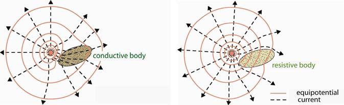
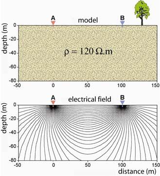
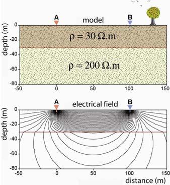
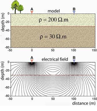
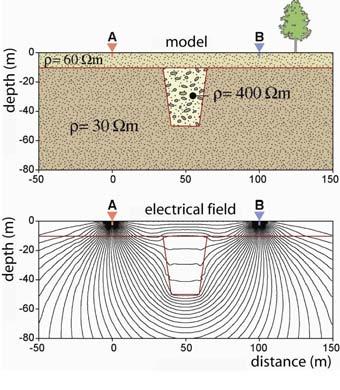
31 Heterogeneous Earth 37

32 38 Reflection and transmission ( ) ( ) ρ ρ ρ ρ + = = k V V N M For r 1 =r 2 =r 3 = + = r k r I V r k I r I V N M π ρ π ρ π ρ
33 39 Modified Snell s Law / tan / tan ρ ρ θ θ = / tan / tan / tan / tan z z x z x z L L L L L L = = = θ θ θ θ / tan / tan / 1/, 1/ / ρ ρ θ θ ρ ρ ρ ρ = = = = z z z z L L L L j V L L j V

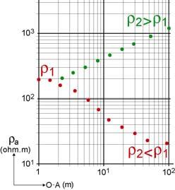
34 tan tanθ θ 1 = 2 ρ2 ρ 1 ρ 1 < ρ 2 ρ 1 > ρ 2 40
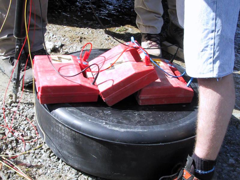
35 Current distribution 41
36 Current distribution 42
37 Current distribution 43

38 Anisotropy S n = S + S + + S = n i=1 h i ρ = i H ρ l T n = T + T + + Tn = i=1 h ρ = i i Hρ t λ = ρt ρ l e.g. λ 1 for alluvium λ >2 for graphitic slates ρ l longitudinal resistivity ρ t transverse resistivity 44 λ coefficient of anisotropy
39 Effect of topography Equipotential: dashed lines 45
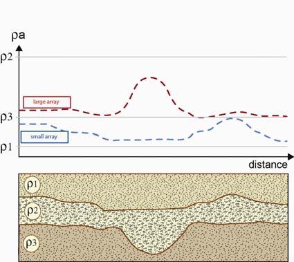
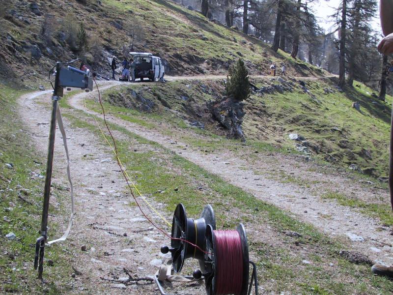
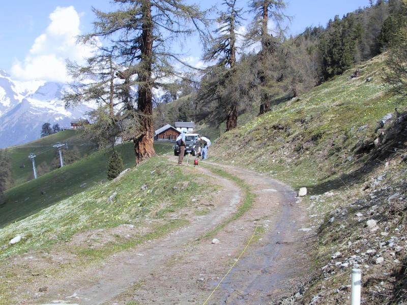
40 3. Survey strategies and interpretation 46
41 Resistivity survey equipment 47
42 48
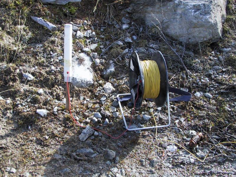
43 Device Current source: batteries in series Voltmeter and ammeter (resistivimeter) Electrodes: metallic stakes current electrodes: stainless steel potential electrodes: stainless steel or impolarizable electrodes Polarization occurs at the contact electrode/ground: this creates an additional potential difference. 49
44 Polarization and skin depth Use an alternating current to avoid polarization Very low frequency (<10 Hz) Skin depth: depth δ at which the amplitude of the field reaches 1/e of its original value a the source δ 503 ρ f 50

45 Contact resistance dr = dl ρ = s dl ρ 2πL 2 R = ρ 1 2π r 1 L L = distance to the centre of the electrode [m] r = radius of the electrode [m] R = resistance [ohm] ρ = resistivity of the surrounding ground [ohm.m] 51
46 To decrease the contact resistance Add electrodes in parallel Increase the current intensity Increase the diameter of the current electrodes Put electrode deeper into the ground Add water (with salt) near the electrodes About 90% of the contact resistance contribution comes from a portion of the ground around the electrode that is equal to 10 times the diameter of the electrode 52
47 Equivalent circuit 53
48 Survey strategies Resistivity mapping, constant separation traversing (CST): used to determine lateral variations of resistivity. The current and potential electrodes are maintained at a fixed separation and moved along profiles Vertical electrical sounding (VES): used in the study of near-horizontal interfaces. The electrode spread is progressively expanded about a central point Resistivity tomography (ERT): is a mix between CST and VES. Also named electrical imaging 54
 55")
49 Constant separation traversing (CST) 55
50 Constant separation traversing (CST) 56
51 Constant separation traversing (CST) 57
52 Constant separation traversing (CST) 58
53 Constant separation traversing (CST) 59
54 Interpretation of CST 60
55 61
56 62
57 63
58 64
59 65
60 66

61 Pontis Nappe Siviez- Mischabel Nappe Unstable area Water infiltration 68
 AB=4m")
62 Small scale resistivity map (archaeology) AB=4m 69

63 Mobile arrays Source: Geocarta, Paris 100 data points/seconde 70 1 data point each 20cm


64 Mobile arrays Source: Geocarta, Paris Vineyards investigations 71
65 Mobile arrays Current injection A B Resistivity measurement (three investigation depths) M2 M1 N1 N2 M3 N3 72 Source: Geocarta, Paris
66 Mapping example with mobile array (spacing 2m) Surface: 155 hectares Apparent resistivity 30 ohm.m 160 ohm.m 73 Source: Geocarta, Paris
67 Mapping example with mobile array (spacing 2m) Surface: 140 hectares Apparent resistivity 15 ohm.m 150 ohm.m 74 Source: Geocarta, Paris
68 Profile spacing 6m Profile spacing 12m Profile spacing 24m Apparent resistivity 10 ohm.m 90 ohm.m 75 Source: Geocarta, Paris
69 Ecartement 0.5m Ecartement 1m Ecartement 2m Apparent resistivity 10 ohm.m 60 ohm.m 76 Source: Geocarta, Paris
70 Vertical electrical sounding (VES) 77

71 Vertical electrical sounding (VES) 78
72 Vertical electrical sounding (VES) 79
73 Vertical electrical sounding (VES) 80
74 81
75 GEOPHYSIC INSTITUT - UNIVERSITY OF LAUSANNE - SWITZERLAND STUDY : SOUNDING: DATE: COORDINATES. OPERATOR: COTE: ρ = K V I K = AM.AN MN π Marks OA en m MN 1m MN 10m MN 60m MN 200m Ven mv I en ma ρ en.m / / / / / / / / / / / / / / / / / /

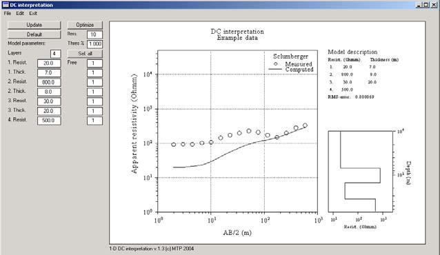
76 One layer and two layers 82
77 83
78 84

79 Three layers and more 85
80 86
81 Equivalence R = hρ R = h ρ 87
82 Parametric sounding A parametric sounding is a VES carried out on an outcrop or near a borehole to precisely determine the resistivity of a geological formation. A precise determination of resistivity reduce the problem of equivalence 88
83 Suppression 89
84 90
85 91
86 Interpretation of VES 92

87 Interpretation of VES 93
88 94
89 95
90 96
91 97
92 98
93 99


94 C7 Application of DC resistivity exploration C7.1 Mapping resistivity structures in 2-D and 3-D Most modern studies using DC resistivity collect data for generating a 2-D or 3-D resistivity model of the Earth. A simple 1-D analysis does not often yield results that are satisfactory. C7.1.1 Cavity detection Studies in karst terrain. Caves show up as very high resistivity zones in a Wenner array profile. Do you think this provide a better way of detecting tunnels than using gravity exploration? Why? In the second example, the DC resistivity survey detected both a known cave and discovered a new (larger) cave that was called the Sting Cave. Figure courtesy of M.H. Loke
 Example from a landfill near Utrecht in the Netherlands.")

95 C7.1.2 Environmental geophysics Conductive plume: (low resistivity) often due to saline water, heavy metals Resistive plume: hydrocarbons, CCl 4 and DNAPLS (dense non-aqueous phase liquids) Example from a landfill near Utrecht in the Netherlands. Contaminated fluids leak into two layers that are characterized by a low resistivity. Locating and mapping landfills. In this example the landfill is higher resistivity than the surroundings. In other cases the landfill will be a low resistivity zone. Why?
.")

96 Note that contaminants leak from surface at the edge of a metal loading dock (shows up as a low resistivity zone). Figure courtesy of M.H. Loke C7.1.3 Hydrocarbon exploration Shallow gas exploration Example from Alberta. Data courtesy of Komex International


97 C7.1.4 Geothermal exploration A geothermal reservoir is generally a low resistivity zone, owing to the presence of saline fluids. The hydrothermal circulation and high temperatures often form a low resistivity clay cap above the reservoir. DC resistivity exploration can be used to locate the clay cap, but DC resistivity is not always effective at locating the underlying reservoirs. Also note that when a geothermal reservoir is depleted, the clay cap will remain. Electromagnetic exploration can be used to map geothermal reservoirs, as discussed in Geophysics 424. Bacman geothermal field Tongonan geothermal field Mayon volcano, Philippines

 11 11 23 Thailand 0.3 0.3 0.3 Turkey 20.6 20.4 20.")
98 Country Argentina Australia China Costa Rica El Salvador Ethiopia France Guatemala Iceland Indonesia Italy Japan Kenya Mexico New Zealand Nicaragua Philippines Russia (Kamchatka) Thailand Turkey USA Total More details Hot dry rock projects


99 C7.1.5 Geotechnical applications Evaluating the hazards posed by landslides. Figure courtesy of M.H. Loke

100 C7.2 Studying the time variation of subsurface resistivity structures. Monitoring the flow of water in the ground and hydrogeology (TLE, October 1998)
 (a) Pre-melt")
 post-melt.")
101 Monitoring in-situ vitrification of radio active waste Spies and Ellis, Cross-borehole resistivity tomography of a pilot scale, in-situ vitrification test, Geophysics, 60, , 1995) (a) Pre-melt (b) maximum amount of melting. The melt body has a low resistivity but is surrounded by a high resistivity halo. Why? (c) post-melt. The melt has frozen to glass and has a high resistivity. MJU November 2005
Electrical Surveying (part A)
") Electrical Surveying (part A) Dr. Laurent Marescot Course given at the University of Fribourg (2009) Contact: laurent@tomoquest.com www.tomoquest.com 1 Introduction Electrical surveying Resistivity method
Electrical Surveying (part A) Dr. Laurent Marescot Course given at the University of Fribourg (2009) Contact: laurent@tomoquest.com www.tomoquest.com 1 Introduction Electrical surveying Resistivity method
B7 Applications of DC resistivity exploration
 B7 Applications of DC resistivity exploration Modern DC resistivity surveys collect data for generating a 2-D or 3-D geoelectric model of the Earth. A simple 1-D analysis does not often yield results that
1. Resistivity of rocks
 RESISTIVITY 1) Resistivity of rocks 2) General principles of resistivity surveying 3) Field procedures, interpretation and examples 4) Summary and conclusions INDUCED POLARIZATION 1) General principles
Geophysics Course Introduction to DC Resistivity
 NORAD supported project in MRRD covering Capacity Building and Institutional Cooperation in the field of Hydrogeology for Faryab Province Afghanistan Geophysics Course Introduction to DC Resistivity By
Electrical prospecting involves detection of surface effects produced by electrical current flow in the ground.
 Electrical Surveys in Geophysics Electrical prospecting involves detection of surface effects produced by electrical current flow in the ground. Electrical resistivity method Induced polarization (IP)
Geophysics Course Interpreting DC Resistivity Data
 NORAD supported project in MRRD covering Capacity Building and Institutional Cooperation in the field of Hydrogeology for Faryab Province Afghanistan Geophysics Course Interpreting DC Resistivity Data
GLE 594: An introduction to applied geophysics
 GLE 594: An introduction to applied geophysics Electrical Resistivity Methods Fall 2004 Earth Properties and Basic Theory Reading Today : 207-218 Next Lecture : 218-228 1 Introduction Link resistivity
Geoelectricity. ieso 2010
 Geoelectricity ieso 2010 1 RESISTIVITY SURVEY AT VENETO VILLA GRITTI AT THE TOWN OF TREVISO (VENETO REGION) The survey was carried out to verify the underground presence of the fondations of a rustic building.
Geophysics for Environmental and Geotechnical Applications
 Geophysics for Environmental and Geotechnical Applications Dr. Katherine Grote University of Wisconsin Eau Claire Why Use Geophysics? Improve the quality of site characterization (higher resolution and
Geology 228/378 Applied and Environmental Geophysics Lecture 6. DC resistivity Surveys
 Geology 228/378 Applied and Environmental Geophysics Lecture 6 DC resistivity Surveys Direct current (DC) Resistivity. Introduction 2. Current flow in the ground 3. Schlumberger, Wenner, dipole-dipole,
Electrical Methods. Resistivity Surveying
 Electrical Methods Resistivity Surveying Geologic Resistivity 1101 Resistivity surveying investigates variations of electrical resistance, by causing an electrical current to flow through the subsurface
LECTURE 10. Module 3 : Field Tests in Rock 3.6 GEOPHYSICAL INVESTIGATION
 LECTURE 10 3.6 GEOPHYSICAL INVESTIGATION In geophysical methods of site investigation, the application of the principles of physics are used to the study of the ground. The soil/rock have different characteristics
ELECTRICAL RESISTIVITY TOMOGRAPHY
 NOTIO Association Clay Technological Centre C/ Río Cabriel s/n 45007 Toledo Tel.: 925 24 11 62 info@notio.es www.notio.es Page 1 / 7 SUMMARY 1. PHYSICAL FUNDAMENTALS OF THE... 3 1.1. ELECTRICAL BEHAVIOR
Electrical imaging techniques for hydrological and risk assessment studies
 Séminaire IPG le 9 mars 2006 Strasbourg Institute of Geophysics ETH Hoenggerberg CH-8093 Zurich Electrical imaging techniques for hydrological and risk assessment studies Laurent Marescot laurent@aug.ig.erdw.ethz.ch
ELECTRICAL PROSPECTING METHODS
 Suez Canal University Faculty of Science Department of Geology ELECTRICAL PROSPECTING METHODS Prepared By El-Arabi Hendi Shendi Professor of applied & environmental Geophysics 2008 1 CONTENTS Definitions
CONTENTS 1. INTRODUCTION. 2. THE D.C. RESISTIVITY METHOD 2.1 Equipment 2.2 Survey Procedure 2.3 Data Reduction
 (i) CONTENTS 1. INTRODUCTION page 1 2. THE D.C. RESISTIVITY METHOD 2.1 Equipment 2.2 Survey Procedure 2.3 Data Reduction 3 3 3 3 3. GEOPHYSICAL RESULTS 3.1 General 3.2 Discussion 4 4 4 4. LIMITATIONS 5
Case Study: University of Connecticut (UConn) Landfill
 Landfill") Case Study: University of Connecticut (UConn) Landfill Problem Statement:» Locate disposal trenches» Identify geologic features and distinguish them from leachate and locate preferential pathways in fractured
Case Study: University of Connecticut (UConn) Landfill Problem Statement:» Locate disposal trenches» Identify geologic features and distinguish them from leachate and locate preferential pathways in fractured
Chapter 13. Groundwater
 Chapter 13 Groundwater Introduction Groundwater is all subsurface water that completely fills the pores and other open spaces in rocks, sediments, and soil. Groundwater is responsible for forming beautiful
APPLICATION OF ELECTRICAL RESISTIVITY TOMOGRAPHY FOR SAND UNDERWATER EXTRACTION
 International Scientific Conference GEOBALCANICA 2018 APPLICATION OF ELECTRICAL RESISTIVITY TOMOGRAPHY FOR SAND UNDERWATER EXTRACTION Maya Grigorova Ivaylo Koprev University of Mining and Geology St. Ivan
Site Characterization & Hydrogeophysics
 Site Characterization & Hydrogeophysics (Source: Matthew Becker, California State University) Site Characterization Definition: quantitative description of the hydraulic, geologic, and chemical properties
Surface and borehole electrical resistivity tomography
 Surface and borehole electrical resistivity tomography Laurent Marescot laurent@tomoquest.com Introduction Surface electrical resistivity surveying is based on the principle that the distribution of electrical
A Case Study of High-Resolution Gravity and Wenner-Schlumberger Resistivity for Geotechnical Engineering: An Example from North Jordan
 Research Journal of Applied Sciences, Engineering and Technology 5(4): 1377-1382-, 2013 ISSN: 2040-7459; e-issn: 2040-7467 Maxwell Scientific Organization, 2013 Submitted: July 09, 2012 Accepted: August
Groundwater Sustainability at Wadi Al Bih Dam, Ras El Khaimah, United Arab Emirates (UAE) using Geophysical methods
 using Geophysical methods") Groundwater Sustainability at Wadi Al Bih Dam, Ras El Khaimah, United Arab Emirates (UAE) using Geophysical methods Ahmed Murad, Amir Gabr, Saber Mahmoud, Hasan Arman & Abdulla Al Dhuhoori Geology Department
Groundwater Sustainability at Wadi Al Bih Dam, Ras El Khaimah, United Arab Emirates (UAE) using Geophysical methods Ahmed Murad, Amir Gabr, Saber Mahmoud, Hasan Arman & Abdulla Al Dhuhoori Geology Department
Consider a Geonics EM31 with the TX and RX dipoles a distance s = 3 m apart.
 E Near field, frequency domain EM systems E.1 EM responses of 1-D resistivity models E.1.1 Response of a halfspace Consider a Geonics EM31 with the TX and RX dipoles a distance s = 3 m apart. The TX and
Definition. Useful References
 Introduction to Geophysics Short Course Assignments http://www.mines.edu/fs_home/tboyd/gp311/modules/res/main.html Definition Resistivity Method - Observation of electric fields caused by current introduced
Resistivity & IP methods
 International PhD Course in HYDROGEOPHYSICS Resistivity & IP methods Andrew Binley Lancaster University Overview We have demonstrated links between hydrological and geophysical properties and show the
2-D Resistivity Study: The Horizontal Resolution Improvement by Introducing the Enhancing Horizontal Resolution (EHR) Technique
 Technique") Open Journal of Geology, 213, 3, 1-6 doi:1.4236/ojg.213.32b1 Published Online April 213 (http://www.scirp.org/journal/ojg) 2-D Resistivity Study: The Horizontal Resolution Improvement by Introducing the
Open Journal of Geology, 213, 3, 1-6 doi:1.4236/ojg.213.32b1 Published Online April 213 (http://www.scirp.org/journal/ojg) 2-D Resistivity Study: The Horizontal Resolution Improvement by Introducing the
Geophysics of Exploration for Water. Geoelectric methods III. edited by Peter Vass
 Geophysics of Exploration for Water Geoelectric methods III edited by Peter Vass The phenomenon of induced polarization was already noticed at the early stage of applying direct current electrical methods
Environmental and Exploration Geophysics I. Resistivity II tom.h.wilson
 Environmental and Exploration Geophysics I Resistivity II tom.h.wilson tom.wilson@mail.wvu.edu Department of Geology and Geography West irginia University Morgantown, W For next class complete in-class
The Efficacy of Enhancing Horizontal Resolution (EHR) Technique in Shallow Subsurface Study Using 2D Resistivity Method at Bukit Bunuh
 Technique in Shallow Subsurface Study Using 2D Resistivity Method at Bukit Bunuh") 212 International Conference on Geological and Environmental Sciences IPCBEE vol.3 6(212) (212)IACSIT Press, Singapoore The Efficacy of Enhancing Horizontal Resolution (EHR) Technique in Shallow Subsurface
212 International Conference on Geological and Environmental Sciences IPCBEE vol.3 6(212) (212)IACSIT Press, Singapoore The Efficacy of Enhancing Horizontal Resolution (EHR) Technique in Shallow Subsurface
Analysis of electrical resistivity data for the determination of aquifer depth at Sapele RD in Benin city
 Available online at www.pelagiaresearchlibrary.com Advances in Applied Science Research, 203, 4(6):268-276 ISSN: 0976-860 CODEN (USA): AASRFC Analysis of electrical resistivity data for the determination
DOWN-HOLE SEISMIC SURVEY AND VERTICAL ELECTRIC SOUNDINGS RABASKA PROJECT, LÉVIS, QUÉBEC. Presented to :
 DOWN-HOLE SEISMIC SURVEY AND VERTICAL ELECTRIC SOUNDINGS RABASKA PROJECT, LÉVIS, QUÉBEC Presented to : TERRATECH 455, René-Lévesque Blvd. West Montreal, Québec HZ 1Z3 Presented by : GEOPHYSICS GPR INTERNATIONAL
Part II: Self Potential Method and Induced Polarization (IP)
") Part II: Self Potential Method and Induced Polarization (IP) Self-potential method (passive) Self-potential mechanism Measurement of self potentials and interpretation Induced polarization method (active)
Part II: Self Potential Method and Induced Polarization (IP) Self-potential method (passive) Self-potential mechanism Measurement of self potentials and interpretation Induced polarization method (active)
GPR profiling and electrical resistivity tomography for buried cavity detection: a test site at the Abbaye de l'ouye (France)
") GPR profiling and electrical resistivity tomography for buried cavity detection: a test site at the Abbaye de l'ouye (France) Nerouz BOUBAKI, Albane SAINTENOY, Piotr TUCHOLKA IDES - UMR 8148 CNRS, Université
GPR profiling and electrical resistivity tomography for buried cavity detection: a test site at the Abbaye de l'ouye (France) Nerouz BOUBAKI, Albane SAINTENOY, Piotr TUCHOLKA IDES - UMR 8148 CNRS, Université
INTRODUCTION TO APPLIED GEOPHYSICS
 INTRODUCTION TO APPLIED GEOPHYSICS EXPLORING THE SHALL0W SUBSURFACE H. Robert Burger Anne F. Sheehan Craig H.Jones VERSITY OF COLORADO VERSITY OF COLORADO W. W. NORTON & COMPANY NEW YORK LONDON Contents
An Introduction to Applied and Environmental Geophysics
 An to Applied and Environmental Geophysics 2nd Edition John M. Reynolds Reynolds International Ltd Preface to the 2 na Edition Acknowledgements 1 1.1 1.2 1.3 1.4 1.5 What are 'applied' and 'environmental'
ธรณ ฟ ส กส อ.ดร. ส ว มล อ ดพ วย
 205482 Geophysics ธรณ ฟ ส กส อ.ดร. ส ว มล อ ดพ วย E-mail: suwimons@hotmail.com Office: GB111-4 ภาคว ชาธรณ ว ทยา คณะว ทยาศาสตร มหาว ทยาล ยเช ยงใหม มหาวทยาลยเชยงใหม GEOPHYSICS Physics of the earth = applies
Hydrological geophysical relationships
 International PhD Course in HYDROGEOPHYSICS Hydrological geophysical relationships Andrew Binley Lancaster University Overview In the course we will concentrate on electrical, electromagnetic and radar
I) Resistivity. Literatur: Telford, Geldart und Sheriff (1990): Applied Geophysics, Second Edition, Cambridge University Press, NY.
 Resistivity. Literatur: Telford, Geldart und Sheriff (1990): Applied Geophysics, Second Edition, Cambridge University Press, NY.") I) Resistivity Literatur: Telford, Geldart und Sheriff (1990): Applied Geophysics, Second Edition, Cambridge University Press, NY. Bender, F. (Hg.) (1985): Angewandte Geowissenschaften, Bd. II, Enke Verlag,
I) Resistivity Literatur: Telford, Geldart und Sheriff (1990): Applied Geophysics, Second Edition, Cambridge University Press, NY. Bender, F. (Hg.) (1985): Angewandte Geowissenschaften, Bd. II, Enke Verlag,
GY 402: Sedimentary Petrology
 UNIVERSITY OF SOUTH ALABAMA GY 402: Sedimentary Petrology Lecture 27: Introduction to Wireline Log Interpretations Instructor: Dr. Douglas W. Haywick Last Time Carbonate Diagenesis Diagenesis 0.5 mm PPL
GLG 471; MICHIGAN STATE UNIVERSITY INSTRUCTOR R.L. VAN DAM PROJECT: ELECTRICAL RESISTIVITY
 GLG 471; MICHIGAN STATE UNIVERSITY INSTRUCTOR R.L. VAN DAM PROJECT: ELECTRICAL RESISTIVITY General information: This is a group (2-3 students) project requiring lab-, computer-, and fieldwork. Work will
CHARACTERIZATION OF SOIL PROFILE OF DHAKA CITY USING ELECTRICAL RESISTIVITY TOMOGRAPHY (ERT)
") CHARACTERIZATION OF SOIL PROFILE OF DHAKA CITY USING ELECTRICAL RESISTIVITY TOMOGRAPHY (ERT) Mehedi Ahmed ANSARY 1, B.S. Pushpendue BISWAS 2 and Abul KHAIR 3 1 Professor, Department of Civil Engineering
CHARACTERIZATION OF SOIL PROFILE OF DHAKA CITY USING ELECTRICAL RESISTIVITY TOMOGRAPHY (ERT) Mehedi Ahmed ANSARY 1, B.S. Pushpendue BISWAS 2 and Abul KHAIR 3 1 Professor, Department of Civil Engineering
The Role of Magnetotellurics in Geothermal Exploration
 The Role of Magnetotellurics in Geothermal Exploration Adele Manzella CNR - Via Moruzzi 1 56124 PISA, Italy manzella@igg.cnr.it Foreword MT is one of the most used geophysical methods for geothermal exploration.
Well Logging. Salam Al Rbeawi 2011
 Well Logging Salam Al Rbeawi 2011 Well Logging: Is a technique used for formation evaluation to determine the size of the reservoir and the amount of oil and gas in place. The following parameters can
Module for: Resistivity Theory (adapted/modified from lectures in PETE 321 (Jensen/Ayers))
)") (PETE 663 Formation Evaluation and the Analysis of Reservoir Performance (Fall 2003)) Module for: Resistivity Theory (adapted/modified from lectures in PETE 321 (Jensen/Ayers)) J. L. Jensen W.B. Ayers
(PETE 663 Formation Evaluation and the Analysis of Reservoir Performance (Fall 2003)) Module for: Resistivity Theory (adapted/modified from lectures in PETE 321 (Jensen/Ayers)) J. L. Jensen W.B. Ayers
2D Resistivity Imaging Investigation of Solid Waste Landfill Sites in Ikhueniro Municipality, Ikpoba Okha Local Government Area,Edo State, Nigeria.
 2D Resistivity Imaging Investigation of Solid Waste Landfill Sites in Ikhueniro Municipality, Ikpoba Okha Local Government Area,Edo State, Nigeria. Iyoha. A, Akhirevbulu O.E, Amadasun C.V.O and Evboumwan
Overview of geophysical methods used in geophysical exploration
 Overview of geophysical methods used in geophysical exploration Lúdvík S. Georgsson United Nations University Geothermal Training Programme Orkustofnun Reykjavík ICELAND The role of the geophysicist Measuring
Magnetotelluric (MT) Method
 Method") Magnetotelluric (MT) Method Dr. Hendra Grandis Graduate Program in Applied Geophysics Faculty of Mining and Petroleum Engineering ITB Geophysical Methods Techniques applying physical laws (or theory) to
Magnetotelluric (MT) Method Dr. Hendra Grandis Graduate Program in Applied Geophysics Faculty of Mining and Petroleum Engineering ITB Geophysical Methods Techniques applying physical laws (or theory) to
MOUNT POLLEY MINING CORPORATION TECHNICAL REPORT ON MULTI-ELECTRODE RESISTIVITY AND SEISMIC REFRACTION SURVEYS MOUNT POLLEY TAILINGS DAM PROJECT
 MOUNT PLEY MINING CORPORATION TECHNICAL REPORT ON MULTI-ELECTRODE RESISTIVITY AND SEISMIC REFRACTION SURVEYS MOUNT PLEY TAILINGS DAM PROJECT LIKELY, B.C. by Claudia Krumbiegel, M.Sc. Cliff Candy, P.Geo.
United Nations University Geothermal Training Programme Iceland
 United Nations University Geothermal Training Programme Iceland Ingvar B. Fridleifsson, director United Nations University Geothermal Training Programme Reykjavik, Iceland www.unugtp.is United Nations
water L v i Chapter 4 Saturation
 4. Resistivity The presence of hydrocarbons is identified by the electrical resistance of the formation. These electrical properties of rocks depend on the pore geometry and fluid distribution. That is,
EOSC252 - Exercise 9
 Name: 1. Introduction EOSC252 - Exercise 9 Dielectric properties This is really nothing more than a multiple choice / short answer quiz-style assignment. You will need to have done the readings about dielectric
Summary. Introduction
 Effect of over- and under-burden on time-lapse CSEM monitoring capabilities Arash JafarGandomi* and Andrew Curtis, School of GeoSciences, The University of Edinburgh, Kings Buildings, Edinburgh EH9 3JW,
Geophysical mapping and imaging of soil structures: basic overview
 Geophysical mapping and imaging of soil structures: basic overview Stéphane Garambois Landslide team, LGIT, Université Joseph Fourier 3D imaging of the water table (seismic) Geophysical methods 1 Plan
Short guide for resistivity and induced polarization tomography
 Short guide for resistivity and induced polarization tomography Address of the manufacturer: GF Instruments, s.r.o. Purkyňova 144 61200 Brno tel: +420 549 522 919 fax: +420 549 522 915 e-mail: info@gfinstruments.cz
INTEGRATED INVESTIGATION TO LOCATE A WASTE DISPOSAL AREA
 INTEGRATED INVESTIGATION TO LOCATE A WASTE DISPOSAL AREA 1 FOR OIL DRILLING PRODUCTS G. APOSTOLOPOULOS 2, K. PAVLOPOULOS 3, C. ANTONIADES 4, I. LOUIS 5 and C. VLACHOU 4 Nestoros 1, 17564 P.Faliron, Athens,
ambiguity in earth sciences IESO Geophysics Section Eddy hartantyo, Lab Geofisika FMIPA UGM
 ambiguity in earth sciences IESO Geophysics Section Eddy hartantyo, Lab Geofisika FMIPA UGM Pelatihan Tahap II IESO Teknik Geologi UGM Februari 2009 1 Introduction Photos from http://www.eegs.org/whatis/
Geoelectrical characterization for liquefaction at coastal zone in South Aceh
 Geoelectrical characterization for liquefaction at coastal zone in South Aceh Muhammad Syukri Laboratory of Geophysics, Department of Physics, Faculty of Mathematic and Sciences, Syiah Kuala University.
Geophysical Applications GPR Ground Penetrating Radar
 Overview: Basics of GPR Radar-wave velocity, attenuation and skin depth Modes of acquisition The Radar-range equation Dielectric properties of materials and relation to porosity Case studies [Archeology,
Prof. Stephen A. Nelson EENS 111. Groundwater
 Page 1 of 8 Prof. Stephen A. Nelson EENS 111 Tulane University Physical Geology This page last updated on 20-Oct-2003 is water that exists in the pore spaces and fractures in rock and sediment beneath
Airborne Geophysics to Map Groundwater. Bill Brown
 Airborne Geophysics to Map Groundwater Bill Brown bb@skytem.com A 6 borehole represents 1 millionth of an acre Aquifer Materials An aquifer is an underground layer of water bearing permeable rock, rock
Azimuthal Resistivity to Characterize Fractures in a Glacial Till. Mark Boris, University of Saskatchewan Jim Merriam, University of Saskatchewan
 Azimuthal Resistivity to Characterize Fractures in a Glacial Till Mark Boris, University of Saskatchewan Jim Merriam, University of Saskatchewan Abstract Azimuthal resistivity was used to characterize
Verification and Validation Calculations Using the STAR Geophysical Postprocessor Suite
 SAIC-03/1040 Final Report Verification and Validation Calculations Using the STAR Geophysical Postprocessor Suite Prepared by: J. W. Pritchett December 2003 Verification and Validation Calculations Using
RESISTIVITY OF ROCKS
 Presented at Short Course IV on Exploration for Geothermal Resources, organized by UNU-GTP, KenGen and GDC, at Lake Naivasha, Kenya, November 1-22, 2009. Kenya Electricity Generating Co., Ltd. GEOTHERMAL
4 Hydro-geophysical methods. 3.2 Technical meetings. 3.3 Additional investigations
 the geological context: outcrops, tilts, directions of identified fractures, profiles observed in wells etc.; the geomorphological context: relief, hydrographic network, potential infiltration zones, floodable
Groundwater Level Monitoring of the Quaternary Aquifer at Al Ain City, United Arab Emirates (UAE) using Geophysical Methods
 using Geophysical Methods") Groundwater Level Monitoring of the Quaternary Aquifer at Al Ain City, United Arab Emirates (UAE) using Geophysical Methods Ahmed Murad & Amir Gabr Geology Department UAE University Outlines Introduction
Groundwater Level Monitoring of the Quaternary Aquifer at Al Ain City, United Arab Emirates (UAE) using Geophysical Methods Ahmed Murad & Amir Gabr Geology Department UAE University Outlines Introduction
Coal Layer Identification using Electrical Resistivity Imaging Method in Sinjai Area South Sulawesi
 Journal of Physics: Conference Series PAPER OPEN ACCESS Coal Layer Identification using Electrical Resistivity Imaging Method in Sinjai Area South Sulawesi To cite this article: Andi Ilham Samanlangi 2018
PROCEEDING, SEMINAR NASIONAL KEBUMIAN KE-8 Academia-Industry Linkage OKTOBER 2015; GRHA SABHA PRAMANA
 INCORPORATION OF ELECTRICAL RESISTIVITY TOMOGRAPHY (ERT) DATA IN GEOLOGICAL MODELLING AS METHOD TO INCREASE MODEL ACCURACY IN UNSERPENTINISED ULTRAMAFIC HOSTED NICKEL LATERITE DEPOSIT Budhi Kumarawarman
The Use of Vertical Electrical Sounding (VES) for Subsurface Geophysical Investigation around Bomo Area, Kaduna State, Nigeria
 for Subsurface Geophysical Investigation around Bomo Area, Kaduna State, Nigeria") IOSR Journal of Engineering (IOSRJEN) e-issn: 2250-3021, p-issn: 2278-8719 Vol. 3, Issue 1 (Jan. 2013), V4 PP 10-15 The Use of Vertical Electrical Sounding (VES) for Subsurface Geophysical Investigation
IOSR Journal of Engineering (IOSRJEN) e-issn: 2250-3021, p-issn: 2278-8719 Vol. 3, Issue 1 (Jan. 2013), V4 PP 10-15 The Use of Vertical Electrical Sounding (VES) for Subsurface Geophysical Investigation
RESISTIVITY IMAGING AND BOREHOLE INVESTIGATION OF THE BANTING AREA AQUIFER, SELANGOR, MALAYSIA. A.N. Ibrahim Z.Z.T. Harith M.N.M.
 JOURNAL OF ENVIRONMENTAL HYDROLOGY The Electronic Journal of the International Association for Environmental Hydrology On the World Wide Web at http://www.hydroweb.com VOLUME 11 2003 RESISTIVITY IMAGING
LIST OF FIGURES APPENDICES
 RESISTIVITY / INDUCED POLARIZATION SURVEY EL PORVENIR PROJECT MUNICIPALITY OF REMEDIOS, ANTIOQUIA, COLOMBIA LOGISTICS REPORT M-17427 APRIL 2017 TABLE OF CONTENTS Abstract... 1 1. The Mandate... 2 2. El
OWNER OPERATOR: BLACKWATER EXPLORATIONS LTD. REPORT ON RESISTIVITY PROFILING SURVEY PLACER GOLD EXPLORATION
 OWNER OPERATOR: BLACKWATER EXPLORATIONS LTD. REPORT ON RESISTIVITY PROFILING SURVEY PLACER GOLD EXPLORATION CARIBOO MINING DISTRICT NTS 93G CLAIM PC682023 Latitude 53 13 35.64 Longitude 122 49 40.65 by
INTRODUCTION TO LOGGING TOOLS
 BY: MUHAMMAD ZAHID INTRODUCTION TO LOGGING TOOLS 1- SPONTANEOUS POTENTIAL (SP) The Spontaneous potential survey, (sp) was one of the first measurements, which was carried out, in a well bore. The SP log
Improved Exploration, Appraisal and Production Monitoring with Multi-Transient EM Solutions
 Improved Exploration, Appraisal and Production Monitoring with Multi-Transient EM Solutions Folke Engelmark* PGS Multi-Transient EM, Asia-Pacific, Singapore folke.engelmark@pgs.com Summary Successful as
Vertical electrical sounding (VES) for subsurface geophysical investigation in Kanigiri area, Prakasam district, Andhra Pradesh, India
 for subsurface geophysical investigation in Kanigiri area, Prakasam district, Andhra Pradesh, India") Available online at www.pelagiaresearchlibrary.com Advances in Applied Science Research, 2014, 5(5):82-86 ISSN: 0976-8610 CODEN (USA): AASRFC Vertical electrical sounding (VES) for subsurface geophysical
Available online at www.pelagiaresearchlibrary.com Advances in Applied Science Research, 2014, 5(5):82-86 ISSN: 0976-8610 CODEN (USA): AASRFC Vertical electrical sounding (VES) for subsurface geophysical
Study on the Four- property Relationship of Reservoirs in YK Area of Ganguyi Oilfield
 Study on the Four- property elationship of eservoirs in YK Area of Ganguyi Oilfield Abstract Xinhu Li, Yingrun Shang Xi an University of Science and Technology, Xi an 710054, China. shangyingrun@163.com
Geo-imaging: An Introduction to Engineering Geophysics
 Geo-imaging: An Introduction to Engineering Geophysics Chih-Ping Lin Distinguished Professor, Department of Civil Engineering & Natural Hazard Mitigation Research Center National Chiao Tung University,
ENVIRONMENTAL AND ENGINEERING GEOPHYSICS
 ENVIRONMENTAL AND ENGINEERING GEOPHYSICS Environmental Engineering MSc 08/09 nd semester COURSE COMMUNICATION DOCUMENT University of Miskolc Faculty of Earth Science and Engineering Institute of Geophysics
 12 10 8 6 4 2 0 40-50 50-60 60-70 70-80 80-90 90-100 Fresh Water What we will cover The Hydrologic Cycle River systems Floods Groundwater Caves and Karst Topography Hot springs Distribution of water in
2D Electrical Resistivity Tomography survey optimisation of solute transport in porous media
 ArcheoSciences Revue d'archéométrie 33 (suppl.) 2009 Mémoire du sol, espace des hommes 2D Electrical Resistivity Tomography survey optimisation of solute transport in porous media Gregory Lekmine, Marc
KARST MAPPING WITH GEOPHYSICS AT MYSTERY CAVE STATE PARK, MINNESOTA
 KARST MAPPING WITH GEOPHYSICS AT MYSTERY CAVE STATE PARK, MINNESOTA By Todd A. Petersen and James A. Berg Geophysics Program Ground Water and Climatology Section DNR Waters June 2001 1.0 Summary A new
Geological data for geothermal evaluation: Italy
 Geological data for geothermal evaluation: Italy Adele Manzella Italy is a geothermal country Italian National Research Council Earth and Environment Department, Geothermal power production: 8,5 % world
Application of Ground Penetrating Radar for hydro-geological study
 Journal of Scientific & Industrial Research Vol. 65, February 2006, pp. 160-164 Application of Ground Penetrating Radar for hydro-geological study K K K Singh* Central Mining Research Institute, Dhanbad
INTERGRATED GEOPHYSICAL METHODS USED TO SITE HIGH PRODUCER GEOTHERMAL WELLS
 Presented at Short Course VII on Exploration for Geothermal Resources, organized by UNU-GTP, GDC and KenGen, at Lake Bogoria and Lake Naivasha, Kenya, Oct. 27 Nov. 18, 2012. GEOTHERMAL TRAINING PROGRAMME
DETECTION OF GROUNDWATER POLLUTION USING RESISTIVITY IMAGING AT SERI PETALING LANDFILL, MALAYSIA
 JOURNAL OF ENVIRONMENTAL HYDROLOGY The Electronic Journal of the International Association for Environmental Hydrology On the World Wide Web at http://www.hydroweb.com VOLUME 8 2000 DETECTION OF GROUNDWATER
An Assessment of Electrical Resistivity Soundings Data by Different Interpretation Techniques
 International Journal of Biological, Ecological and Environmental Sciences (IJBEES) Vol. 1, No. 3, 212 ISSN 2277 4394 An Assessment of Electrical Resistivity Soundings Data by Different Interpretation
Received 12 February 2010 Accepted 25 March Abstract. Keywords: sounding resistivity, gem-bearing gravel layer, Wenner, Schlumberger
 One Dimensional Resistivity Sounding for Resolving Gem-bearing Gravel Layer: A Comparison of Schlumberger with Wenner Techniques at Bo Rai, Eastern Thailand Piyaphong Chenrai 1, Punya Charusiri 1* and
S.I. Fadele, M.Sc. 1 ; P.O. Sule, Ph.D. 1 ; and B.B.M. Dewu, Ph.D * ABSTRACT
 The Use of Vertical Electrical Sounding (VES) for Groundwater Exploration around Nigerian College of Aviation Technology (NCAT), Zaria, Kaduna State, Nigeria. S.I. Fadele, M.Sc. 1 ; P.O. Sule, Ph.D. 1
Verification of Archie Constants Using Special Core Analysis and Resistivity Porosity Cross Plot Using Picket Plot Method
 Int'l Journal of Computing, Communications & Instrumentation Engg. (IJCCIE) Vol. 4, Issue (207) ISSN 2349-469 EISSN 2349-477 Verification of Archie Constants Using Special Core Analysis and Resistivity
E : Ground-penetrating radar (GPR)
") Geophysics 3 March 009 E : Ground-penetrating radar (GPR) The EM methods in section D use low frequency signals that trael in the Earth by diffusion. These methods can image resistiity of the Earth on
Geophysics 3 March 009 E : Ground-penetrating radar (GPR) The EM methods in section D use low frequency signals that trael in the Earth by diffusion. These methods can image resistiity of the Earth on
THE UNIVERSITY OF TRINIDAD & TOBAGO
 THE UNIVERSITY OF TRINIDAD & TOBAGO B. A. SC. PETROLEUM ENGINEERING ALTERNATE 2012 FINAL EXAMINATIONS Course Code and Title: Programme: DATE: DURATION: FMEV 2002 - BASIC WELL LOGGING BASc B.A.SC. Petroleum
Well Logging Importance in Oil and Gas Exploration and Production
 Well Logging Importance in Oil and Gas Exploration and Production Dr. R. Giri Prasad 1 1 Associate Professor, Dept. of Petroleum Engineering, Aditya Engineering College, hod_pt@aec.edu.in I. INTRODUCTION
Earth Resistance and Calculation of Earthing
 University of Ljubljana Faculty of Electrical Engineering Earth Resistance and Calculation of Earthing Seminar paper at subject Distribution and Industrial Systems Student: Mentor: Prof. dr. Grega Bizjak
LITTLE ABOUT BASIC PETROPHYSICS
 LITTLE ABOUT BASIC PETROPHYSICS Author: MUHAMMAD ZAHID M.Sc (Applied Geology) Specialization in Petrophysics University of Azad Jammu & Kashmir, Muzaffarabad. ENTER Introduction - Determination of Physical
Determining the Relationship between Resistivity, Water and Hydrocarbon Saturation of Rock Formation Using Composite Well Logs
 Determining the Relationship between Resistivity, Water and Hydrocarbon Saturation of Rock Formation Using Composite Well Logs Doi:10.5901/ajis.2013.v2n13p119 Absract Mamudu Afizu Department of Physics,
Permafrost monitoring at Mölltaler Glacier and Magnetköpfl
 Permafrost monitoring at Mölltaler Glacier and Magnetköpfl DAVID OTTOWITZ 1, BIRGIT JOCHUM 1, ROBERT SUPPER 1, ALEXANDER RÖMER 1, STEFAN PFEILER 1 and MARKUS KEUSCHNIG 2, 3 1 Department of Geophysics,
Applied Geophysics for Environmental Site Characterization and Remediation
 Applied Geophysics for Environmental Site Characterization and Remediation MSECA Webinar September 24, 2015 John Mundell, P.E., L.P.G. Ryan Brumbaugh, L.P.G. MUNDELL & ASSOCIATES, INC. Webinar Objective
Before writing the discipline examinations, candidates must have passed, or have been exempted from, the Basic Studies Examinations.
 INTRODUCTION The Canadian Engineering Qualifications Board of Engineers Canada issues the Examination Syllabus that includes a continually increasing number of engineering disciplines. Each discipline
Groundwater. (x 1000 km 3 /y) Oceans Cover >70% of Surface. Groundwater and the. Hydrologic Cycle
 Oceans Cover >70% of Surface. Groundwater and the. Hydrologic Cycle") Chapter 17 Oceans Cover >70% of Surface Groundwater and the Hydrologic Cycle Vasey s Paradise, GCNP Oceans are only 0.025% of Mass Groundwater Groundwater is liquid water that lies in the subsurface in
Chapter 17 Oceans Cover >70% of Surface Groundwater and the Hydrologic Cycle Vasey s Paradise, GCNP Oceans are only 0.025% of Mass Groundwater Groundwater is liquid water that lies in the subsurface in
Groundwater. (x 1000 km 3 /y) Reservoirs. Oceans Cover >70% of Surface. Groundwater and the. Hydrologic Cycle
 Reservoirs. Oceans Cover >70% of Surface. Groundwater and the. Hydrologic Cycle") Chapter 13 Oceans Cover >70% of Surface Groundwater and the Hydrologic Cycle Oceans are only 0.025% of Mass Groundwater Groundwater is liquid water that lies in the subsurface in fractures in rocks and
Chapter 13 Oceans Cover >70% of Surface Groundwater and the Hydrologic Cycle Oceans are only 0.025% of Mass Groundwater Groundwater is liquid water that lies in the subsurface in fractures in rocks and