Geo-imaging: An Introduction to Engineering Geophysics
|
|
|
- Sherilyn Blair
- 5 years ago
- Views:
Transcription


1 Geo-imaging: An Introduction to Engineering Geophysics Chih-Ping Lin Distinguished Professor, Department of Civil Engineering & Natural Hazard Mitigation Research Center National Chiao Tung University, Taiwan Ex. Considerations in landslide assessment Geological model and material properties Slip surface/geometry of the sliding block Detection and monitoring of slope movement


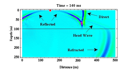
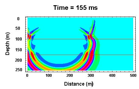
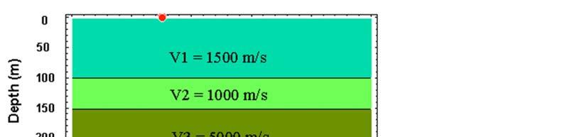
 P-wave velocity (Traveltime) Reflection")
2 The Role of Geophysics Investigation of geological structure Measurement of related physical properties Geotechnical Testing Geophysical Methods Sampling SPT,CPT DMT, PMT VST Mechanical response Small sample volume Small coverage High spatial resolution 1D2D3D Non-destructive Complementary Seismic wave Electrical EM wave Physical properties Large sample volume Large coverage Low spatial resolution Geo-imaging methods Resistivity (ERT) P-wave velocity (Traveltime) Reflection S-wave velocity (Surface Wave)

3 Geophysics for Slope Stability (Hack 2000) Geophysics for Slope Stability (Bell et al. 2006)

4 Geophysics for Slope Stability (Jongmans & Garambois 2007) Part I Seismic Methods Seismic waves and properties Seismic methods Borehole seismic Down-hole Cross-hole Suspension Cross-hole Tomography Surface seismic Refraction Reflection Surface Wave Principle Applications Limitations Guideline


5 Seismic waves Surface waves Compressional waves Shear waves Body Wave in Layered Media 10
 Vs Constrained Vp modulus (M) Damping Viscous damping D Deformation Strength")
6 Seismic Wave Seismic wave properties Elastic modulus Young s modulus (E) Poisson s ratio () Shear modulus (G) Vs Constrained Vp modulus (M) Damping Viscous damping D Deformation Strength Dynamic
7 Seismic wave velocity saturated Seismic Properties P-wave velocity vs. Unconfined compressive strength (Ookubo and Terasaki, 1971)


8 Seismic wave velocity Seismic Properties (Hada, 1984)


9 Seismic Methods Borehole/Penetration Methods Down-hole Cross-hole Suspension Cross-hole Tomography Surface Methods Refraction Reflection Surface Wave Seismic Downhole Method 震源 震測儀 裸孔或 PVC 套管 孔內受波器 ASTM Standard: ASTM D Standard Test Method for Downhole Seismic Testing

10 Borehole Seismic Borehole Seismic


11 Characteristics of Downhole Test Requires only one borehole Work in cased holes Less expensive Some space is required to place the source S/N decreases with increasing depth Spatial resolution also decreases with depth 21 Seismic Crosshole Method ASTM Standard: ASTM D4428 Standard Test Method for Crosshole Seismic Testing
 50 60 Depth (m) 50 60 70 70 80 80 90 100 110 2 4 6 Time (ms) 90 100 110 2 4 6 Time (ms) Limitations: - Casing?")
12 Characteristics of Crosshole Test Most reliable Work in cased holes Accuracy and resolution does not decrease with increasing depth Requires at least 2 boreholes Borehole distance < 9 m Borehole deviation 23 Suspension PS-Logger Suspension 0 H1 0 H Depth (m) Depth (m) Time (ms) Time (ms) Limitations: - Casing? - water required - V Sensitivity

 Cross-hole")
13 Characteristics of PS Logging Fast Accuracy and resolution does not decrease with increasing depth Water-filled borehole required Results may be affected by casing Receiver spacing is short (1 m) Cross-hole Tomography


14 Surface Seismic Methods 1 2 N-1 N x 1 dx :Source :Receiver x 1 :Near offset L dx:receiver interval L :Receiver spread Seismic Equipment 28

15 Seismic Refraction Method Snell s Law i r V 1 t V 2 29 Determining Earth Structure From Travel Time Curve Low Velocity Over High Velocity Halfspace


16 Refraction Method Multiple Subsurface Model Refraction Method Hidden Layers Low Velocity Layer


17 Thin, large velocity contrast layer Interpretation of Dipping Layers

 t 0 /2 t 0 /2 Refraction")
18 More General Interpretation -The Reciprocal Method Depth term: t 0 =T AP +T BP -T AB Velocity term: T AP -t 0 /2 = 1/2T AB -1/2(T AP -T BP ) t 0 /2 t 0 /2 Refraction Tomography

19 Refraction Method Surface+Borehole Traveltime Tomography (Optim, 2001) Planning of Survey Geophone spread and direction Geophone spread Investigation depth No. of Channel & Receiver interval 24 channel are the most common Tyically 5 meter for shallow & 10 m for deep Source location 7 points method 9 points method source receiver / geophone 38 use 1/3 or ¼ line length


20 Refraction Method Data Acquisition Traveltime Curve Tomography Inversion 39 GRM Analysis Limitations of Seismic Refraction Depth: Typically < 30 m. Deeper depth requires explosives and long geophone spread Resolution: Typically resolve 3~4 layers, vertical resolution is limited by the accuracy of travel time (1 ms error induces ~1m depth error for surface layers and ~2-10 m for deeper layers) and depends on velocity contrast, lateral resolution = f (geophone spacing) Hidden layers Seismic velocity must increases with depth Will not detect thin layers Narrow shear zone with low velocity Lateral refraction in the horizontal plan Measurement sensitive to acoustic noise and vibration A source to geophone distance of 5 (or more) times the desired depth of investigation is needed

21 Seismic Reflection Method Principle Applications: Characterize geological structures Common Midpoint Survey Normal moveout correction Velocity Analysis Note: Before stacking, several data processing may be involved.


22 Walkaway noise test Survey Plan
 Operations are difficult in areas of steep topography or uneven surfaces.")
23 Limitations of Seismic Reflection Depth: ten s m~ hundred s m Resolution: vertical resolution depends on wavelength (as good as 1m for 500 Hz), lateral resolution depends on geophone spacing (typically 0.3~3m) Operations are difficult in areas of steep topography or uneven surfaces. Measurements labor intensive, data processing complicated Measurement sensitive to acoustic noise and vibration Difficult to perform shallow depth (< 30 m) seismic reflection
24 Seismic Surface Wave Method Frequency component Geophones V S V S1 V S2 Time (s) z V S3 V Inversion Dispersion curve f Field Testing Dispersion analysis Dispersion of Rayleigh Wave
25 Surface Wave Methods Two-Station Method (SASW) Multi-Station Method (MASW) Surface Wave SASW Method x (rad) Unwrapping in f domain V ph (m/s) X=8 X=16 X= f (Hz) f(hz) Low frequency important, esp. for large x v( f ) 2f ( f ) x
 40 50 60 70 Frequency (Hz) 40 50 60 70 Frequency, f (Hz) 40 50 60 70 0.8 80 80 80 0.")
 k N 1 ( fi, v) n0 U ( f i, x n ) exp j 2f i v x n Surface Wave")
26 MASW Method MWTSW MSASW Time (s) frequency (Hz) Frequency (Hz) Frequency, f (Hz) Offset (m) Offset (m) R Phase Velocity, v ph (m/s) k N 1 ( fi, v) n0 U ( f i, x n ) exp j 2f i v x n Surface Wave Tomography Surface Wave Methods Survey Line Data Acquisition National Chiao Tung Unversity
27 Limitations of Surface Wave Method It s basically a 1-D method Resolution and accuracy decreases with increasing depth Investigation depth is typically less than 30 m Inversion considering effect of multiple modes needs further study Part II Electrical/Electromagnetic methods Electrical Properties Electrical Methods Electromagnetic Wave Method Time Domain Reflectometry (TDR) Ground Penetration Radar (GPR) Electrical methods (Potential measurement) DC resistivity Spontaneous Potential Electromagnetic Induction Frequency Domain EM Time Domain EM Principle Applications Limitations Guideline
28 Electrical Properties Electrical Conductivity: dc EM wave Attenuation Dielectric Permittivity: r EM wave Velocity + O H (a) H - (b) E (c) Geo-electrical properties Type of geomaterial, water content, pore water properties, 55 Electrical Properties Electrical Properties Dielectric Permittivity r ( f ) r '( f ) jr ''( f ) Electrical Conductivity dc Equivalent Dielectric Permittivity * ' j r r ii r dc r ' j r " 2f 0 (Hilhorst, 1998)
29 Electrical vs. Geo Properties High-frequency dielectric permittivity is mainly a function of water content Dielectric dispersion is related to water content, soil density, and soil type Electrical conductivity is related to pore water characteristics, water content, soil density, and soil type Soil/Rock conditions vs. resistivity Conditions Changes of rock/soil resistivity Low High Remarks Resistivity of groundwater and pore water Low High Salinity, salt water wedge Degree of water saturation High Low Ground water Porosity (saturated) Large Small Clay fraction Many Few Soil type Degree of weathering and Strong Slight Strength alteration Temperature High Low Geothermal
30 Electrical Methods Borehole/Penetration Methods Time domain reflectometry (TDR) Down-hole resistivity/radar Cross-hole resistivity/radar tomography Surface Methods Ground penetration radar DC resistivity Self potential Frequency domain Electromagnetic Time domain electromagnetic TDR: Measurement of Electrical Properties TDR Step pulse generator v 0 Coaxial cable Sampler Waveguide V s /2 V f Apparent dielectric constant v 2L / T c / Ka Ka = f( r d ) Electrical conductivity EC=f( r d water EC) Lin et al. (2008&2009)
 R 2 = 0.932 y = 9.4273x + 0.9969 R 2 = 0.9688 0 0 0.05 0.1 0.15 0.2 0.25 w Topp's Equation Topp s equation 2 4 2 6 3 5.3 2.92 10 K a 5.510 K a 4.")
31 Water Content Measurement based on Ka sqrt(k a ) w / d K a (Lin, 1999) Measured Linear Regression Volumetric Water Content Empirical Relation (Lin, 1999) R 2 = y = x R 2 = w Topp's Equation Topp s equation K a K a K a Refractive Index Linear K K a d a a ASTM D6780 w Equivalently, b c a bw Ka= f( r d soil type) d K a (Topp, 1980) (Ledieu et al., 1986) (Siddique and Drnevich, 1995) d a b Note: 0 and d 0, Ka=0 instead of 1 (air), But fit as good as Ledieu et al. (1986) for soils. w Borehole Radar 62 Limitations: - penetration distance


 Mapping")

32 Cross-hole Radar Tomography Velocity Dielectric Constant Attenuation Conductivity (Jhou et al. 2001) Cross-hole Radar Mapping moisture content changes due to tracer input (Binley, 2004)


33 Ground Penetrating Radar Limitations: -Penetration depth -Velocity analysis -Reflection pattern Survey Type 66


34 25 MHz, up to 40 depth (Otto & Sass, 2006) DC Resistivity Method 1 Resistivity vs. Resistance 2 Single point current source in half space r P


35 A practical way of measuring resistivity I V K r r r r I V V p P a Depth of current penetration vs. current electrode spacing DC Resistivity
 71 Vertical Electrical Sounding Schlumberger and Wenner")
36 Electrode Array (M.H. Loke., 2015) 71 Vertical Electrical Sounding Schlumberger and Wenner array are commonly used for sounding


37 Electrical Resistivity Tomography (ERT) 2D Electrical Resistivity Tomography (ERT) 74


38 Electrical Resistivity Tomography(ERT) 1D 2D 3D (Bichler et al. 2004) 76


39 DC Resistivity Time-lapse ERT Limitations of DC Resistivity Method Measurement susceptible, but less so than EM measurements, to interference from nearby metal objects Obtaining a good connection with the ground can sometimes be a problem Sensitivity (resolution) decreases significantly with increasing depth and depends on resistivity distribution


40 Borehole Resistivity 79 Cross-borehole ERT 80

41 Self-Potential Method Principle Applications: Investigation of subsurface water movement Electromagnetic Induction A suite of techniques to measure resistivity, complementary to DC resistivity method. Frequency Domain EM Time Domain EM Very Low Frequency (VLF) Pipe/cable locator Metal Detector

42 Geophysical logging Borehole caliper Velocity Density Resistivity Self Potential Natural Gamma Televiewer Hydrophysical Logging Optical/Acoustic Televiewer 84


43 Acoustic Televiewer Travel time Magnitude 東勢坑溪 Probe Acoustic televiewer measures: Acoustic travel time and reflection magnitude Sonde inclination and azimuth Optical Televiewer BOTV Camera LED 86

 DC resistivity Spontaneous Potential Electromagnetic Induction Frequency Domain EM")
44 Televiewer data analysis Borehole deviation Breakout/ovalisation Log Structural/Fracture Analysis Borehole cross-section 87 Summary of Geophysical Methods Seismic waves and properties Seismic methods Borehole seismic Down-hole Cross-hole Suspension Cross-hole Tomography Surface seismic Refraction Reflection Surface Wave Electrical Properties Electrical Methods Electromagnetic Wave Method Time Domain Reflectometry Ground Penetration Radar Electrical methods (Potential measurement) DC resistivity Spontaneous Potential Electromagnetic Induction Frequency Domain EM Time Domain EM
45 Thank You! Chih-Ping Lin Distinguished Professor, Department of Civil Engineering & Natural Hazard Mitigation Research Center National Chiao Tung University, Taiwan
Geophysical Site Investigation (Seismic methods) Amit Prashant Indian Institute of Technology Gandhinagar
 Amit Prashant Indian Institute of Technology Gandhinagar") Geophysical Site Investigation (Seismic methods) Amit Prashant Indian Institute of Technology Gandhinagar Short Course on Geotechnical Aspects of Earthquake Engineering 04 08 March, 2013 Seismic Waves
Geophysical Site Investigation (Seismic methods) Amit Prashant Indian Institute of Technology Gandhinagar Short Course on Geotechnical Aspects of Earthquake Engineering 04 08 March, 2013 Seismic Waves
Site Characterization & Hydrogeophysics
 Site Characterization & Hydrogeophysics (Source: Matthew Becker, California State University) Site Characterization Definition: quantitative description of the hydraulic, geologic, and chemical properties
LECTURE 10. Module 3 : Field Tests in Rock 3.6 GEOPHYSICAL INVESTIGATION
 LECTURE 10 3.6 GEOPHYSICAL INVESTIGATION In geophysical methods of site investigation, the application of the principles of physics are used to the study of the ground. The soil/rock have different characteristics
Geophysics for Environmental and Geotechnical Applications
 Geophysics for Environmental and Geotechnical Applications Dr. Katherine Grote University of Wisconsin Eau Claire Why Use Geophysics? Improve the quality of site characterization (higher resolution and
Geotechnical / Geophysical Investigation
 FEATURES TerraDol provides innovative geotechnical and geophysical exploration for civil construction projects including highway, railroad, subway, tunnel, bridge, port, and underground storage projects.
Geophysical mapping and imaging of soil structures: basic overview
 Geophysical mapping and imaging of soil structures: basic overview Stéphane Garambois Landslide team, LGIT, Université Joseph Fourier 3D imaging of the water table (seismic) Geophysical methods 1 Plan
Mechanical Wave Measurements. Electromagnetic Wave Techniques. Geophysical Methods GEOPHYSICAL SITE CHARACTERIZATION. Mechanical Wave Geophysics
 Geophysical Methods GEOPHYSICAL SITE CHARACTERIZATION Mechanical Wave Measurements Electromagnetic Wave Techniques Mechanical Wave Measurements Crosshole Tests (CHT) Downhole Tests (DHT) Spectral Analysis
High Resolution Geophysics: A Better View of the Subsurface. By John Jansen, P.G., Ph.D., Aquifer Science and Technology
 High Resolution Geophysics: A Better View of the Subsurface By John Jansen, P.G., Ph.D., Aquifer Science and Technology Geologist Use Only Part of the Information Available To Them Most Geologist rely
SEISMIC RADAR AND ELECTRICAL TECHNIQUES FOR WASTE DISPOSAL ASSESSMENT. M. Pipan, G. Dal Moro, E. Forte & M. Sugan
 SEISMIC RADAR AND ELECTRICAL TECHNIQUES FOR WASTE DISPOSAL ASSESSMENT M. Pipan, G. Dal Moro, E. Forte & M. Sugan Department of Geological, Environmental and Marine Sciences, University of Trieste Via Weiss,
Site characterization at the Groundwater Remediation Field Laboratory
 Site characterization at the Groundwater Remediation Field Laboratory WILLIAM P. C LEMENT, STEVE CARDIMONA, ANTHONY L. ENDRES, Boston College, Boston, Massachusetts KATHARINE KADINSKY-CADE, Phillips Laboratory,
DOWN-HOLE SEISMIC SURVEY AND VERTICAL ELECTRIC SOUNDINGS RABASKA PROJECT, LÉVIS, QUÉBEC. Presented to :
 DOWN-HOLE SEISMIC SURVEY AND VERTICAL ELECTRIC SOUNDINGS RABASKA PROJECT, LÉVIS, QUÉBEC Presented to : TERRATECH 455, René-Lévesque Blvd. West Montreal, Québec HZ 1Z3 Presented by : GEOPHYSICS GPR INTERNATIONAL
Static Corrections for Seismic Reflection Surveys
 Static Corrections for Seismic Reflection Surveys MIKE COX Volume Editors: Series Editor: Eugene F. Scherrer Roland Chen Eugene F. Scherrer Society of Exploration Geophysicists Tulsa, Oklahoma Contents
INTRODUCTION TO APPLIED GEOPHYSICS
 INTRODUCTION TO APPLIED GEOPHYSICS EXPLORING THE SHALL0W SUBSURFACE H. Robert Burger Anne F. Sheehan Craig H.Jones VERSITY OF COLORADO VERSITY OF COLORADO W. W. NORTON & COMPANY NEW YORK LONDON Contents
SEISMIC SURVEY METHODS
 SEISMIC SURVEY METHODS Seismic methods Seismic surveys are used in geology and geotechnical engineering to: a) define the depth of the bedrock; b) investigate the landslide areas, c) check the structural
DEVELOPMENT OF EMPIRICAL CORRELATION BETWEEN SHEAR WAVE VELOCITY AND STANDARD PENETRATION RESISTANCE IN SOILS OF CHENNAI CITY
 DEVELOPMENT OF EMPIRICAL CORRELATION BETWEEN SHEAR WAVE VELOCITY AND STANDARD PENETRATION RESISTANCE IN SOILS OF CHENNAI CITY Uma Maheswari R 1, Boominathan A 2 and Dodagoudar G.R 3 1 Research Scholar,
Instructional Objectives
 GE 6477 DISCONTINUOUS ROCK 8. Fracture Detection Dr. Norbert H. Maerz Missouri University of Science and Technology (573) 341-6714 norbert@mst.edu Instructional Objectives 1. List the advantages and disadvantages
FUNDAMENTALS OF ENGINEERING GEOLOGY
 FUNDAMENTALS OF ENGINEERING GEOLOGY Prof. Dr. HUSSEIN HAMEED KARIM Building and Construction Engineering Department 2012 Preface The impulse to write this book stemmed from a course of geology given by
CENTER FOR INFRASTRUCTURE ENGINEERING STUDIES
 1 CENTER FOR INFRASTRUCTURE ENGINEERING STUDIES Acquisition of an Engineering Seismograph By Dr. Neil Anderson UTC RE116 University Transportation Center Program at The University of Missouri-Rolla 2 Disclaimer
1. Resistivity of rocks
 RESISTIVITY 1) Resistivity of rocks 2) General principles of resistivity surveying 3) Field procedures, interpretation and examples 4) Summary and conclusions INDUCED POLARIZATION 1) General principles
An Introduction to Applied and Environmental Geophysics
 An to Applied and Environmental Geophysics 2nd Edition John M. Reynolds Reynolds International Ltd Preface to the 2 na Edition Acknowledgements 1 1.1 1.2 1.3 1.4 1.5 What are 'applied' and 'environmental'
Geophysical Applications GPR Ground Penetrating Radar
 Overview: Basics of GPR Radar-wave velocity, attenuation and skin depth Modes of acquisition The Radar-range equation Dielectric properties of materials and relation to porosity Case studies [Archeology,
Chapter 1 Introduction
 Chapter 1 Introduction 1.1 Statement of the Problem Engineering properties of geomaterials are very important for civil engineers because almost everything we build - tunnels, bridges, dams and others
A Comparison of Four Geophysical Methods for Determining the Shear Wave Velocity of Soils
 A Comparison of Four Geophysical Methods for Determining the Shear Wave Velocity of Soils Neil Anderson 1, Thanop Thitimakorn 1, David Hoffman 2, Richard Stephenson 2, Ronaldo Luna 2 Geological Sciences
PART A: Short-answer questions (50%; each worth 2%)
") PART A: Short-answer questions (50%; each worth 2%) Your answers should be brief (just a few words) and may be written on these pages if you wish. Remember to hand these pages in with your other exam pages!
PART A: Short-answer questions (50%; each worth 2%) Your answers should be brief (just a few words) and may be written on these pages if you wish. Remember to hand these pages in with your other exam pages!
Seismoelectric Ground-flow DC-4500 Locator
 Seismoelectric Ground-flow DC-4500 Locator Introduction The seismoelectric survey is a new technology combined the electro kinetic potential method and geophysical technology. It is applied directly to
Geophysics Course Interpreting DC Resistivity Data
 NORAD supported project in MRRD covering Capacity Building and Institutional Cooperation in the field of Hydrogeology for Faryab Province Afghanistan Geophysics Course Interpreting DC Resistivity Data
GLE 594: An introduction to applied geophysics
 GL 594: An introduction to applied geophysics Ground Penetrating Radar Fall 005 Ground Penetrating Radar Reading Today: 309-316 Next class: 316-39 Introduction to GPR Using the reflection (and sometimes
Case Study: University of Connecticut (UConn) Landfill
 Landfill") Case Study: University of Connecticut (UConn) Landfill Problem Statement:» Locate disposal trenches» Identify geologic features and distinguish them from leachate and locate preferential pathways in fractured
Case Study: University of Connecticut (UConn) Landfill Problem Statement:» Locate disposal trenches» Identify geologic features and distinguish them from leachate and locate preferential pathways in fractured
NSE 3.7. SEG/Houston 2005 Annual Meeting 1121
 Julian Ivanov,* Richard D. Miller, Kansas Geological Survey, The University of Kansas; Robert F. Ballard, Jr., Joseph B. Dunbar, U.S. Army Engineer Research and Development Center (ERDC) Geotechnical and
Hamed Aber 1 : Islamic Azad University, Science and Research branch, Tehran, Iran. Mir Sattar Meshin chi asl 2 :
 Present a Proper Pattern for Choose Best Electrode Array Based on Geological Structure Investigating in Geoelectrical Tomography, in order to Get the Highest Resolution Image of the Subsurface Hamed Aber
ERTH2020 Introduction to Geophysics The Seismic Method. 1. Basic Concepts in Seismology. 1.1 Seismic Wave Types
 ERTH2020 Introduction to Geophysics The Seismic Method 1. Basic Concepts in Seismology 1.1 Seismic Wave Types Existence of different wave types The existence of different seismic wave types can be understood
Beyond Rippability A Case History Integrating Seismic Refraction, Electrical Resistivity Imaging, and Geotechnical Boring Logs
 Beyond Rippability A Case History Integrating Seismic Refraction, Electrical Resistivity Imaging, and Geotechnical Boring Logs Jonathan B. Shawver 1 (jb@geovision.com), William Dalrymple 1 (will@geovision.com),
Patterns in Geophysical Data and Models
 Patterns in Geophysical Data and Models Jens Tronicke Angewandte Geophysik Institut für Geowissenschaften Universität Potsdam jens@geo.uni-potsdam.de Near-surface geophysics Using geophysical tools to
3. Magnetic Methods / 62
 Contents Preface to the Second Edition / xv Excerpts from Preface to the FirstEdition / xvii Mathematical Conventions / xix 1. Introduction / 1 Reference / 5 2. Gravity Methods / 6 2. I. Introduction /
Improved Exploration, Appraisal and Production Monitoring with Multi-Transient EM Solutions
 Improved Exploration, Appraisal and Production Monitoring with Multi-Transient EM Solutions Folke Engelmark* PGS Multi-Transient EM, Asia-Pacific, Singapore folke.engelmark@pgs.com Summary Successful as
An Introduction to Geophysical Exploration
 An Introduction to Geophysical Exploration Philip Kearey Department of Earth Sciences University of Bristol Michael Brooks Ty Newydd, City Near Cowbridge Vale of Glamorgan Ian Hill Department of Geology
Manual on Subsurface Investigations National Highway Institute Publication No. FHWA NHI Federal Highway Administration Washington, DC
 Manual on Subsurface Investigations National Highway Institute Publication No. FHWA NHI-01-031 Federal Highway Administration Washington, DC Geotechnical Site Characterization July 2001 by Paul W. Mayne,
MT Prospecting. Map Resistivity. Determine Formations. Determine Structure. Targeted Drilling
 MT Prospecting Map Resistivity Determine Formations Determine Structure Targeted Drilling Cross-sectional interpretation before and after an MT survey of a mineral exploration prospect containing volcanic
MOUNT POLLEY MINING CORPORATION TECHNICAL REPORT ON MULTI-ELECTRODE RESISTIVITY AND SEISMIC REFRACTION SURVEYS MOUNT POLLEY TAILINGS DAM PROJECT
 MOUNT PLEY MINING CORPORATION TECHNICAL REPORT ON MULTI-ELECTRODE RESISTIVITY AND SEISMIC REFRACTION SURVEYS MOUNT PLEY TAILINGS DAM PROJECT LIKELY, B.C. by Claudia Krumbiegel, M.Sc. Cliff Candy, P.Geo.
Geophysics Course Introduction to DC Resistivity
 NORAD supported project in MRRD covering Capacity Building and Institutional Cooperation in the field of Hydrogeology for Faryab Province Afghanistan Geophysics Course Introduction to DC Resistivity By
Joint inversion of geophysical and hydrological data for improved subsurface characterization
 Joint inversion of geophysical and hydrological data for improved subsurface characterization Michael B. Kowalsky, Jinsong Chen and Susan S. Hubbard, Lawrence Berkeley National Lab., Berkeley, California,
Lesson 1 Introduction to geophysical methods Emanuele Forte
 Lesson 1 Introduction to geophysical methods Emanuele Forte 3 rd September 2016 Naxos, Greece 1 Outline - What is Geophysics - Base concepts: (Geo)Physical parameters Sensitivity Resolution - Active and
Hybrid Seismic Survey on the Gamanjunni Rockslide Site
 Hybrid Seismic Survey on the Gamanjunni Rockslide Site by Walter Frei; info@geoexpert.ch NVE Workshop / Oslo 30.-31. January 2017 (1) Pictorial Introduction to Hybrid Seismic Profiling (2) Recommended
Walkaway Seismic Experiments: Stewart Gulch, Boise, Idaho
 Walkaway Seismic Experiments: Stewart Gulch, Boise, Idaho Lee M. Liberty Center for Geophysical Investigation of the Shallow Subsurface Boise State University Boise, Idaho 1. Summary CGISS conducted walkaway
EOS 350 MIDTERM OCT 4, 2013 STUDENT NAME: TEAM #:
 EOS 350 MIDTERM OCT 4, 2013 STUDENT NAME: TEAM #: Some equations which may, or may not, be useful: Distance from sensor to a dipole z ~ x ½, Distance to line of dipoles z ~ 0.75x ½ B = μh, M = κh Seismic
UChile - LMMG Shear Wave Velocity (V S. ): Measurement, Uncertainty, and Utility in Seismic Hazard Analysis. Robb Eric S. Moss, Ph.D., P.E.
: Measurement, Uncertainty, and Utility in Seismic Hazard Analysis. Robb Eric S. Moss, Ph.D., P.E.") UChile - LMMG 2015 Shear Wave Velocity (V S ): Measurement, Uncertainty, and Utility in Seismic Hazard Analysis Robb Eric S. Moss, Ph.D., P.E. Assoc. Prof. of Earthquake, Geotechnical, and Risk Engineering
UChile - LMMG 2015 Shear Wave Velocity (V S ): Measurement, Uncertainty, and Utility in Seismic Hazard Analysis Robb Eric S. Moss, Ph.D., P.E. Assoc. Prof. of Earthquake, Geotechnical, and Risk Engineering
Downhole Seismic Velocity Logging Test
 Objective Downhole Seismic Velocity Logging Test In this experiment, Velocity Logging Test (Downhole method) is done to find the physical properties of the soil ground from site investigation. Velocity
Optimum acquisition and processing parameters for multichannel analysis of surface waves using 3D electrical resistivity tomography as control
 Scholars' Mine Masters Theses Student Theses and Dissertations Summer 2015 Optimum acquisition and processing parameters for multichannel analysis of surface waves using 3D electrical resistivity tomography
Electrical Surveying (part A)
") Electrical Surveying (part A) Dr. Laurent Marescot Course given at the University of Fribourg (2009) Contact: laurent@tomoquest.com www.tomoquest.com 1 Introduction Electrical surveying Resistivity method
Electrical Surveying (part A) Dr. Laurent Marescot Course given at the University of Fribourg (2009) Contact: laurent@tomoquest.com www.tomoquest.com 1 Introduction Electrical surveying Resistivity method
CORRELATION BETWEEN GEOTECHNICAL AND GEOPHYSICAL PROPERTIES OF SOIL
 CORRELATION BETWEEN GEOTECHNICAL AND GEOPHYSICAL PROPERTIES OF SOIL by NASTARAN SHIRGIRI A Thesis submitted to The University of Birmingham For the degree of MASTER OF PHILOSOPHY School of CIVIL ENGINEERING
Electrical Resistivity Survey for Delineating Seawater Intrusion in a Coastal Aquifer
 Electrical Resistivity Survey for Delineating Seawater Intrusion in a Coastal Aquifer Sung-Ho Song*, Gyu-Sang Lee*, Jin-Sung Kim*, Baekuk Seong*, Young-gyu Kim*, Myung-Ha Woo* and Namsik Park** Abstract
INTRODUCTION TO LOGGING TOOLS
 BY: MUHAMMAD ZAHID INTRODUCTION TO LOGGING TOOLS 1- SPONTANEOUS POTENTIAL (SP) The Spontaneous potential survey, (sp) was one of the first measurements, which was carried out, in a well bore. The SP log
Magnetotelluric (MT) Method
 Method") Magnetotelluric (MT) Method Dr. Hendra Grandis Graduate Program in Applied Geophysics Faculty of Mining and Petroleum Engineering ITB Geophysical Methods Techniques applying physical laws (or theory) to
Magnetotelluric (MT) Method Dr. Hendra Grandis Graduate Program in Applied Geophysics Faculty of Mining and Petroleum Engineering ITB Geophysical Methods Techniques applying physical laws (or theory) to
FINAL REPORT GEOPHYSICAL INVESTIGATION WATER TOWER NO. 6 SITE PLANT CITY, FL
 APPENDIX B FINAL REPORT GEOPHYSICAL INVESTIGATION WATER TOWER NO. 6 SITE PLANT CITY, FL Prepared for Madrid Engineering Group, Inc. Bartow, FL Prepared by GeoView, Inc. St. Petersburg, FL February 28,
University of Wyoming Near-Surface Geophysical Instrument Center & Wyoming Center for Environmental Hydrology and Geophysics
 University of Wyoming Near-Surface Geophysical Instrument Center & Wyoming Center for Environmental Hydrology and Geophysics UWNSG & WyCEHG Groundwater Studies on the Brule Formation near Pine Bluffs,
INTERROGATING LEVEES IN TEXAS, NEW MEXICO, AND NEW ORLEANS USING VARIOUS SEISMIC METHODS. Abstract
 INTERROGATING LEVEES IN TEXAS, NEW MEXICO, AND NEW ORLEANS USING VARIOUS SEISMIC METHODS Downloaded 07/03/14 to 129.237.143.21. Redistribution subject to SEG license or copyright; see Terms of Use at http://library.seg.org/
Geoelectricity. ieso 2010
 Geoelectricity ieso 2010 1 RESISTIVITY SURVEY AT VENETO VILLA GRITTI AT THE TOWN OF TREVISO (VENETO REGION) The survey was carried out to verify the underground presence of the fondations of a rustic building.
Ultra high-resolution seismic and GPR imaging of permafrost. Devon Island, Nunavut
 Ultra high-resolution seismic and GPR imaging of permafrost. Devon Island, Nunavut Carlos E. Nieto* and Robert R. Stewart CREWES. The University of Calgary, 2500 University Dr., N.W., Calgary, AB, T2N
Soil Mechanics and Foundation Engineering, Vol. 53, No. 1, March, 2016 (Russian Original No. 1, January-February, 2016)
") Soil Mechanics and Foundation Engineering, Vol. 53, No. 1, March, 2016 (Russian Original No. 1, January-February, 2016) SLOPE MONITORING STUDY USING SOIL MECHANICS PROPERTIES AND 4-D ELECTRICAL RESISTIVITY
Soil Mechanics and Foundation Engineering, Vol. 53, No. 1, March, 2016 (Russian Original No. 1, January-February, 2016) SLOPE MONITORING STUDY USING SOIL MECHANICS PROPERTIES AND 4-D ELECTRICAL RESISTIVITY
Geophysical techniques for investigating shallow and deep landslides: results in the framework of PREVIEW project (FP6 UE)
") Geophysical techniques for investigating shallow and deep landslides: results in the framework of PREVIEW project (FP6 UE) Perrone, A; Piscitelli, S; Lampenna, V; Lamporte, A; Giocolli, A; Dahlin, Torleif
Geophysical techniques for investigating shallow and deep landslides: results in the framework of PREVIEW project (FP6 UE) Perrone, A; Piscitelli, S; Lampenna, V; Lamporte, A; Giocolli, A; Dahlin, Torleif
Oil and Gas Research Institute Seismic Analysis Center Faults Detection Using High-Resolution Seismic Reflection Techniques
 Oil and Gas Research Institute Seismic Analysis Center Faults Detection Using High-Resolution Seismic Reflection Techniques Ghunaim T. Al-Anezi (KACST) March 2013 1 Objectives The objective of the survey
SUBMITTAL FEASIBILITY STUDY GEOPHYSICAL INVESTIGATION SAN JUAN BASIN SAN JUAN CAPISTRANO, CALIFORNIA. GEOVision Project No
 SUBMITTAL FEASIBILITY STUDY GEOPHYSICAL INVESTIGATION SAN JUAN BASIN SAN JUAN CAPISTRANO, CALIFORNIA GEOVision Project No. 15027 Prepared for Santa Margarita Water District 26111 Antonio Parkway Rancho
Comparison of geophysical. techniques to determine depth to. bedrock in complex weathered. environments of the Mount Crawford. region, South Australia
 Comparison of geophysical techniques to determine depth to bedrock in complex weathered environments of the Mount Crawford region, South Australia Thesis submitted in accordance with the requirements of
7.2.1 Seismic waves. Waves in a mass- spring system
 7..1 Seismic waves Waves in a mass- spring system Acoustic waves in a liquid or gas Seismic waves in a solid Surface waves Wavefronts, rays and geometrical attenuation Amplitude and energy Waves in a mass-
TABLE OF CONTENTS CHAPTER TITLE PAGE TITLE PAGE DECLARATION DEDIDATION ACKNOWLEDGEMENTS ABSTRACT ABSTRAK
 TABLE OF CONTENTS CHAPTER TITLE PAGE TITLE PAGE DECLARATION DEDIDATION ACKNOWLEDGEMENTS ABSTRACT ABSTRAK TABLE OF CONTENTS LIST OF TABLE LIST OF FIGURES LIST OF SYMBOLS LIST OF APENDICES i ii iii iv v
Enhanced In-Situ Testing for Geotechnical Site Characterization. Graduate Course CEE 6423
 Enhanced In-Situ Testing for Geotechnical Site Characterization SPT, VST, DMT, PMT, CHT, DHT, CPT Graduate Course CEE 6423 Paul W. Mayne, PhD, P.E. Professor, Geosystems Program Civil & Environmental Engineering
Study on Rayleigh Wave Inversion for Estimating Shear-wave Velocity Profile
 PROC. ITB Eng. Science Vol. 35 B, No. 1, 2003, 11-22 11 Study on Rayleigh Wave Inversion for Estimating Shear-wave Velocity Profile T.A. Sanny*, Yoes Avianto* *Geophysical Engineering Department, Faculty
GEOPHYSICAL INVESTIGATIONS FOR IDENTIFICATION OF SUBSURFACE. Arindam Dey Assistant Professor Department of Civil Engineering IIT Guwahati
 GEOPHYSICAL INVESTIGATIONS FOR IDENTIFICATION OF SUBSURFACE STRATIGRAPHY AT IIT GUWAHATI Arindam Dey Assistant Professor Department of Civil Engineering IIT Guwahati What is MASW NDT Procedures SRS, GPR,
Department of Geophysics Faculty of Earth Sciences King Abdulaziz University
 Department of Geophysics Faculty of Earth Sciences King Abdulaziz University Dr. Mansour A. Al-Garni Office: room 233/Buld. 27 OR Dept. chair office/buld. 55 Introduction to Geophysics EGP 211 Time: 10-10:55
Sensors & Transducers 2015 by IFSA Publishing, S. L.
 Sensors & Transducers, Vol. 87, Issue 4, April 05, pp. 39-43 Sensors & Transducers 05 by IFSA Publishing, S. L. http://www.sensorsportal.com Characteriations of Soil Profiles through Electric Resistivity
Lima Project: Seismic Refraction and Resistivity Survey. Alten du Plessis Global Geophysical
 Lima Project: Seismic Refraction and Resistivity Survey Alten du Plessis Global Geophysical Report no 0706/2006 18 December 2006 Lima Project: Seismic Refraction and Resistivity Survey by Alten du Plessis
Hydrogeophysics - Seismics
 Hydrogeophysics - Seismics Matthias Zillmer EOST-ULP p. 1 Table of contents SH polarized shear waves: Seismic source Case study: porosity of an aquifer Seismic velocities for porous media: The Frenkel-Biot-Gassmann
Soil Behaviour in Earthquake Geotechnics
 Soil Behaviour in Earthquake Geotechnics KENJI ISHIHARA Department of Civil Engineering Science University of Tokyo This publication was supported by a generous donation from the Daido Life Foundation
Reflection Seismic Method
 Reflection Seismic Method Data and Image sort orders; Seismic Impedance; -D field acquisition geometries; CMP binning and fold; Resolution, Stacking charts; Normal Moveout and correction for it; Stacking;
TIME DOMAIN REFLECTOMETRY (TDR) IN MEASURING WATER CONTENTS AND HYDRATE SATURATIONS IN MARINE SEDIMENTS
 IN MEASURING WATER CONTENTS AND HYDRATE SATURATIONS IN MARINE SEDIMENTS") Proceedings of the 7th International Conference on Gas Hydrates (ICGH 2011), Edinburgh, Scotland, United Kingdom, July 17-21, 2011. TIME DOMAIN REFLECTOMETRY (TDR) IN MEASURING WATER CONTENTS AND HYDRATE
Proceedings of the 7th International Conference on Gas Hydrates (ICGH 2011), Edinburgh, Scotland, United Kingdom, July 17-21, 2011. TIME DOMAIN REFLECTOMETRY (TDR) IN MEASURING WATER CONTENTS AND HYDRATE
Seismic and geoelectrical field explorations for parameter estimation in geotechnics
 Bauhaus-University Weimar / Germany Seismic and geoelectrical field explorations for parameter estimation in geotechnics Site Parameter Investigations and Site Monitoring Dipl.-Ing. Frank Wuttke Dr.-Ing.
Correlation Between P-wave Velocity and Strength Index for Shale to Predict Uniaxial Compressive Strength Value
 Correlation Between P-wave Velocity and Strength Index for Shale to Predict Uniaxial Compressive Strength Value H. Awang 1, N. R. Ahmad Rashidi 1, M. Yusof 1,*, and K. Mohammad 2 1 Institute for Infrastructure
Resistivity & IP methods
 International PhD Course in HYDROGEOPHYSICS Resistivity & IP methods Andrew Binley Lancaster University Overview We have demonstrated links between hydrological and geophysical properties and show the
Chapter 7: Reflection Seismology Homework Solutions (Jan. 2010)
") Chapter 7: eflection Seismology Homework Solutions (Jan. 200). Why do marine seismic reflection surveys not record (a) S waves? (b) refracted rays? 2 μ a) For ideal fluid, μ=0, thus, v s = = 0 ρ b) eflection
Chapter 7: eflection Seismology Homework Solutions (Jan. 200). Why do marine seismic reflection surveys not record (a) S waves? (b) refracted rays? 2 μ a) For ideal fluid, μ=0, thus, v s = = 0 ρ b) eflection
Hydrological geophysical relationships
 International PhD Course in HYDROGEOPHYSICS Hydrological geophysical relationships Andrew Binley Lancaster University Overview In the course we will concentrate on electrical, electromagnetic and radar
Fr Reservoir Monitoring in Oil Sands Using a Permanent Cross-well System: Status and Results after 18 Months of Production
 Fr-01-03 Reservoir Monitoring in Oil Sands Using a Permanent Cross-well System: Status and Results after 18 Months of Production R. Tondel* (Statoil ASA), S. Dümmong (Statoil ASA), H. Schütt (Statoil ASA),
CROSSHOLE RADAR TOMOGRAPHY IN AN ALLUVIAL AQUIFER NEAR BOISE, IDAHO. Abstract. Introduction
 CROSSHOLE RADAR TOMOGRAPHY IN AN ALLUVIAL AQUIFER NEAR BOISE, IDAHO William P. Clement, Center for Geophysical Investigation of the Shallow Subsurface, Boise State University, Boise, ID, 83725 Warren Barrash,
Feasibility of MASW (Multi-Channel Analysis of Surface Waves) for Evaluating the Dynamic Properties of Geofoam
 for Evaluating the Dynamic Properties of Geofoam") Geosynthetics 2013 April 1-4, Long Beach, California Feasibility of MASW (Multi-Channel Analysis of Surface Waves) for Evaluating the Dynamic Properties of Geofoam Masood H. Kafash, Graduate Research Assistant,
Geosynthetics 2013 April 1-4, Long Beach, California Feasibility of MASW (Multi-Channel Analysis of Surface Waves) for Evaluating the Dynamic Properties of Geofoam Masood H. Kafash, Graduate Research Assistant,
A scale/resolution problem
 Near Surface 2005 September 4-7, 2005, Palermo Italy WORKSHOP on Hydrogeophysics a tool for sustainable use of groundwater resources Integrated Seismic and GPR characterization of fractured rocks Pipan,
Groundwater Sustainability at Wadi Al Bih Dam, Ras El Khaimah, United Arab Emirates (UAE) using Geophysical methods
 using Geophysical methods") Groundwater Sustainability at Wadi Al Bih Dam, Ras El Khaimah, United Arab Emirates (UAE) using Geophysical methods Ahmed Murad, Amir Gabr, Saber Mahmoud, Hasan Arman & Abdulla Al Dhuhoori Geology Department
Groundwater Sustainability at Wadi Al Bih Dam, Ras El Khaimah, United Arab Emirates (UAE) using Geophysical methods Ahmed Murad, Amir Gabr, Saber Mahmoud, Hasan Arman & Abdulla Al Dhuhoori Geology Department
Lesson 2 Geophysical methods for rock mass characterization Emanuele Forte
 Lesson 2 Geophysical methods for rock mass characterization Emanuele Forte 3 rd September 2016 Naxos, Greece Outline Review of geophysical methods and their applicability to rock mass characterization:
Techniques for determining the structure and properties of permafrost
 Stanford Exploration Project, Report 80, May 15, 2001, pages 1 404 Techniques for determining the structure and properties of permafrost Ray Abma 1 ABSTRACT Several methods for predicting the relationship
KARST MAPPING WITH GEOPHYSICS AT MYSTERY CAVE STATE PARK, MINNESOTA
 KARST MAPPING WITH GEOPHYSICS AT MYSTERY CAVE STATE PARK, MINNESOTA By Todd A. Petersen and James A. Berg Geophysics Program Ground Water and Climatology Section DNR Waters June 2001 1.0 Summary A new
Basim R. Hijab, Amer Al-Khalidy University of Baghdad, Department of Earth Science
 INTEGRATED GEOPHYSICAL TESTS FOR THE GEOTECHNICAL CHARACTERIZATION OF THE SANDY FOUNDATION FOR PROPOSED METRO- TUNNEL AT THE NAJAF AREA, SOUTHERN IRAQ. Ammar M.Shakir, Flora Garofalo, Sebastiano Foti Politecnico
ambiguity in earth sciences IESO Geophysics Section Eddy hartantyo, Lab Geofisika FMIPA UGM
 ambiguity in earth sciences IESO Geophysics Section Eddy hartantyo, Lab Geofisika FMIPA UGM Pelatihan Tahap II IESO Teknik Geologi UGM Februari 2009 1 Introduction Photos from http://www.eegs.org/whatis/
3D Converted Wave Data Processing A case history
 P-290 3D Converted Wave Data Processing A case history N. B. R. Prasad, ONGC Summary In recent years, there has been a growing interest in shear- wave exploration for hydrocarbons as it facilitates to
Vollständige Inversion seismischer Wellenfelder - Erderkundung im oberflächennahen Bereich
 Seminar des FA Ultraschallprüfung Vortrag 1 More info about this article: http://www.ndt.net/?id=20944 Vollständige Inversion seismischer Wellenfelder - Erderkundung im oberflächennahen Bereich Thomas
Downloaded 07/03/14 to Redistribution subject to SEG license or copyright; see Terms of Use at
 Applications of the JARS Method to study levee sites in southern Texas and southern New Mexico Julia Ivanov*, Richard D. Miller, Jianghai Xia, Kansas Geological Survey, Lawrence, KS Joseph B. Dunbar, Engineer
Oak Ridge IFRC. Quantification of Plume-Scale Flow Architecture and Recharge Processes
 Oak Ridge IFRC Quantification of Plume-Scale Flow Architecture and Recharge Processes S. Hubbard *1, G.S. Baker *2, D. Watson *3, D. Gaines *3, J. Chen *1, M. Kowalsky *1, E. Gasperikova *1, B. Spalding
Seismic applications in coalbed methane exploration and development
 Seismic applications in coalbed methane exploration and development Sarah E. Richardson*, Dr. Don C. Lawton and Dr. Gary F. Margrave Department of Geology and Geophysics and CREWES, University of Calgary
Geophysical Investigation of Ground Water Using Vertical Electrical Sounding and Seismic Refraction Methods
 International Journal of Petroleum and Petrochemical Engineering (IJPPE) Volume 2, Issue 1, 2016, PP 6-11 ISSN 2454-7980 (Online) www.arcjournals.org Geophysical Investigation of Ground Water Using Vertical
CHARACTERIZATION OF SOIL PROFILE OF DHAKA CITY USING ELECTRICAL RESISTIVITY TOMOGRAPHY (ERT)
") CHARACTERIZATION OF SOIL PROFILE OF DHAKA CITY USING ELECTRICAL RESISTIVITY TOMOGRAPHY (ERT) Mehedi Ahmed ANSARY 1, B.S. Pushpendue BISWAS 2 and Abul KHAIR 3 1 Professor, Department of Civil Engineering
CHARACTERIZATION OF SOIL PROFILE OF DHAKA CITY USING ELECTRICAL RESISTIVITY TOMOGRAPHY (ERT) Mehedi Ahmed ANSARY 1, B.S. Pushpendue BISWAS 2 and Abul KHAIR 3 1 Professor, Department of Civil Engineering
Surface and borehole electrical resistivity tomography
 Surface and borehole electrical resistivity tomography Laurent Marescot laurent@tomoquest.com Introduction Surface electrical resistivity surveying is based on the principle that the distribution of electrical
Improved Hydrogeophysical Parameter Estimation from Empirical Mode Decomposition Processed Ground Penetrating Radar Data
 University of South Carolina Scholar Commons Faculty Publications Earth and Ocean Sciences, Department of 12-1-2009 Improved Hydrogeophysical Parameter Estimation from Empirical Mode Decomposition Processed