MT Prospecting. Map Resistivity. Determine Formations. Determine Structure. Targeted Drilling
|
|
|
- Julia Mills
- 5 years ago
- Views:
Transcription
1

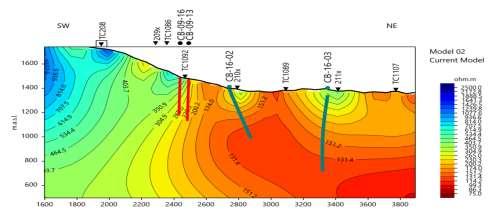
2 MT Prospecting Map Resistivity Determine Formations Determine Structure Targeted Drilling Cross-sectional interpretation before and after an MT survey of a mineral exploration prospect containing volcanic rocks.
3 MT Overview Magnetotellurics (MT) is a geophysical method for imaging the electrical resistivity and structure of the earth, from the near-surface down to hundreds of kilometers. MT is a passive geophysical method which uses natural electromagnetic field variations (caused by solar radiation/particles or atmospheric sources, e.g., lightning discharges), which induce electric currents in the subsurface. Magneto inferring magnetic fields and telluric inferring electric fields in the ground (tellus, Latin for earth ).

4 Resistivity Ranges Electrical resistivity of rocks and minerals is an important physical property to measure as part of attempts to understand geological structures and processes. It varies by many orders of magnitude, from very resistive crystalline igneous rocks, to very conductive saline-filled sedimentary rocks.


5 Technology Comparison Depth information is obtained by measuring the time variations over a range of frequencies. High frequencies penetrate into the earth to shallow depths only, while low frequencies penetrate deeper. Information is obtained from a few tens of metres depth to hundreds of kilometres depth.

6 MT Signal Sources Worldwide lightning activity at frequencies of 10,000 Hz to 1 Hz and geomagnetic micropulsations at frequencies of 1 Hz to Hz provide the majority of natural signal used by the MT method. Varying on hourly, daily, yearly cycles Ground Wave Lightning Solar Wind 10,000 1, Frequency in Hz
7 Applications and Benefits Exploration Base metals (nickel and precious metal exploration, as well as for kimberlite) mapping High-resistivity surface (volcanics, carbonates, igneous) Overthrust, fold belts, volcanics Can be combined with seismic or other methods to enhance understanding Explores to depths in excess of 500m, typically kilometers Geothermal Energy Mapping of very deep seated structures bearing high temperature fluids. Reconnaissance or Detail Detail: prospect definition - spacing = 250m - 500m on profiles or grids Recon: areal coverage - spacing = 1-5 km on profiles or grids Adaptable In any topography stations can be put out, in even the roughest conditions Multiple profile directions can be provided from a single survey
8 Advantages and disadvantages of MT Data Pros Great depth of penetration (10's of kms) No transmitter or source required Light-weight equipment --very portable Good production rate (2-5 km/day) Better resolution than gravity/mag Well-developed and fast interpretation procedure Little impact on environment Can access almost anywhere Cons Static Shift - Near-surface distortions to electric field created by resistivity variation at surface additional TDEM data required for correction Static shift of apparent resistivity curves sometimes significant Resolution less than seismic Data processing and modeling are complex Inversion techniques rely on smooth models, tougher to interpret in complex areas

9 Survey Planning Customized survey layouts are constructed to cover areas of interest. Denser and coarser stations layout according to size and target depth. In the field stations are placed where the best contacts are available with both safe access and within reasonable specifications. Profiles are created as per geological strike and client requirements. Data are analyzed to client specifications, either single profile directions, or multiple as shown.


10 Data Acquisition & Field Setup Five channels at each station Flexible site locations Two to five stations simultaneously No Line restrictions GPS synchronization between stations 24-hour recording/layout/pickup cycle In-field processing and editing
11 Site Deployment
 Electric X Electric Y Magnetic X Magnetic Y Magnetic Z Magnetic X R Magnetic X R 1000 sec")
12 Remote MT - Data Record The time series record, showing (from top) electric and magnetic data varying with time for five channels plus remote reference (i.e. for correction) Electric X Electric Y Magnetic X Magnetic Y Magnetic Z Magnetic X R Magnetic X R 1000 sec
13 How Resistivity is Computed Impedance tensor is measured at surface Computing apparent resistivity (and phase) as a function of frequency a 1 Ex / Hy 2 r a 5f Two values computed, r xy and r yx, for the two orthogonal pairs of Electric and Magnetic sensors in horizontal directions, Thus can interpret for strike and dip directions
14 Depth of Investigation The depth of investigation is a result of the frequency and resistivity of the subsurface (Skin depth) Lower frequency = deeper penetration Higher resistivity = deeper penetration Skin depth is an approximate estimate of depth of penetration at particular frequency and resistivity Skin depth (in meters) = 500 r / r f where = resistivity and f = frequency
15 Processing and Interpretation Process Raw time series data to create a database Multiple Tensors (components) Review all Tensors (components) for QA/QC Review the initial data to ensure it makes geological/geophysical sense Production of 1D ( sounding) models ( Depth Profiles) Perform any valid edits / filtering for noise or signal strength Produce 2D inversion models using the latest software Combine and produce 3D representations of data and inversions Create Coloured Cross-sections and Maps Integration with Geology, Drill Holes and Legacy Data


16 Many Data Components Apparent Resistivity with Tensor Data Phase Showing Tensor Data Tipper Magnetics and Tensor Data Dimensionality Typical Exploration Range
 Magnetics Vertical Magnetics with depth Complex Complicated Induction Vectors Useful in detecting conductors Dimensionality (Polar Diagrams)")
17 Data Analysis Shallow Resistive Conductive Deep Apparent Resistivity Apparent resistivity changes in 2 directions (x and y depending on layout) Deeper Conductor Phase Phase changes in 2 directions Resistive Conductive Deeper Conductor Tipper (Vertical) Magnetics Vertical Magnetics with depth Complex Complicated Induction Vectors Useful in detecting conductors Dimensionality (Polar Diagrams) Defines Layers, 1D to 3D, i.e. complexity

18 1D - Depth Profiles Defines Layering under a single station (sounding) Apparent resistivity changes in multiple layers under each station Layers are determined from near surface to great depths Models help to QA/QC all data Data collection enables kilometers of depth information This sounding shows good data to over 10km Multiple sites are combined to produce a 2D image of the property Depending on the survey design, many profiles (lines) can be extracted, giving both strike and cross strike profile information

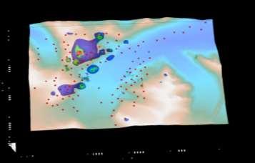
19 2D - Sections Multiple sites are combined and inverted Mapping of conductive and resistive areas Structural Interpretation Resistive Zone Future Drill Planning


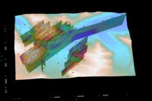
20 MT Sections 3D - Presentation Presentation of Multiple Cross-sections to Analyse Changes Property Wide Understanding Near Surface and Deep Geological Understanding Integration and Compilation of Different Data Sets in One Database Good Drill Hole Results! 3D Magnetics
21 The Exploration Process Survey Design Data QA/QC 1D Target Generation 3D 2D
Magnetotelluric (MT) Method
 Method") Magnetotelluric (MT) Method Dr. Hendra Grandis Graduate Program in Applied Geophysics Faculty of Mining and Petroleum Engineering ITB Geophysical Methods Techniques applying physical laws (or theory) to
Magnetotelluric (MT) Method Dr. Hendra Grandis Graduate Program in Applied Geophysics Faculty of Mining and Petroleum Engineering ITB Geophysical Methods Techniques applying physical laws (or theory) to
An Experimental Magnetotelluric Short Sounding During High Sun Spot Activity Cycle in 2013
 Proceedings World Geothermal Congress 2015 Melbourne, Australia, 19-25 April 2015 An Experimental Magnetotelluric Short Sounding During High Sun Spot Activity Cycle in 2013 Lendriadi AGUNG and Imam B.
Peter R. Milligan. Stephan Thiel. Geoscience Australia. The University of Adelaide. MT acquisition & processing
 Magnetotelluric acquisition & processing, with examples from the Gawler Craton, Curnamona Province and Curnamona- Gawler Link transects in South Australia Peter R. Milligan Geoscience Australia Stephan
1D and 2D Inversion of the Magnetotelluric Data for Brine Bearing Structures Investigation
 1D and 2D Inversion of the Magnetotelluric Data for Brine Bearing Structures Investigation Behrooz Oskooi *, Isa Mansoori Kermanshahi * * Institute of Geophysics, University of Tehran, Tehran, Iran. boskooi@ut.ac.ir,
Introducing the Stratagem EH4. Electrical Conductivity Imaging System Hybrid-Source Magnetotellurics
 Introducing the Stratagem EH4 Electrical Conductivity Imaging System Hybrid-Source Magnetotellurics Stratagem EH4 Hybrid-Source Magnetotellurics Frequency range of 10 Hz to 90k Hz Approx. depth of investigation
SUPPLEMENTARY INFORMATION
 SUPPLEMENTARY INFORMATION Supplementary online material for Bai et al., (2). EHS3D MT data collection Broadband magnetotelluric (MT) data were recorded on profiles P, P2 and P4 in the frequency band -.5
Magnetotelluric and Controlled-Source Electromagnetic Study of Aquistore CO 2 Sequestration Site, near Estevan, Saskatchewan
 Magnetotelluric and Controlled-Source Electromagnetic Study of Aquistore CO 2 Sequestration Site, near Estevan, Saskatchewan Joe, B, McLeod 1, Ian, J, Ferguson 1, Jim Craven 2, Brian Roberts 2, Eric Roots
RESISTIVITY SURVEYING AND ELECTROMAGNETIC METHODS
 Presented at Short Course VII on Surface Exploration for Geothermal Resources, organized by UNU-GTP and LaGeo, in Santa Tecla and Ahuachapán, El Salvador, March 14-22, 2015. GEOTHERMAL TRAINING PROGRAMME
Gravity-Magnetic & Magneto-Telluric surveys in Purnea Onland Basin, India - A case history.
 P-281 Gravity-Magnetic & Magneto-Telluric surveys in Purnea Onland Basin, India - A case history. Summary A.K. Roy, D.P. Paine*, S. Sett, and H.N. Bhattacharya, ONGC This paper describes a case history
APPENDIX A: Magnetotelluric Data in Relation to San Pedro Mesa Structural. The San Pedro Mesa structural high (discussed in main text of paper) was
 was") Page of DR for GSA Special Paper 9, Chapter, Geophysical constraints APPENDIX A: Magnetotelluric Data in Relation to San Pedro Mesa Structural High The San Pedro Mesa structural high (discussed in main
Page of DR for GSA Special Paper 9, Chapter, Geophysical constraints APPENDIX A: Magnetotelluric Data in Relation to San Pedro Mesa Structural High The San Pedro Mesa structural high (discussed in main
Data Repository Comeau et al., (2015)
") Data Repository 2015087 Comeau et al., (2015) 1. Magnetotelluric data Owing to the remote location, and large distance from sources of electromagnetic noise, most stations were characterized by high quality
Data Repository 2015087 Comeau et al., (2015) 1. Magnetotelluric data Owing to the remote location, and large distance from sources of electromagnetic noise, most stations were characterized by high quality
Western EARS Geothermal Geophysics Context Mar-2016 William Cumming
 Western EARS Geothermal Geophysics Context Mar-2016 William Cumming Cumming Geoscience, Santa Rosa CA wcumming@wcumming.com Office: +1-707-546-1245 Mobile: +1-707-483-7959 Skype: wcumming.com Kibiro Geophysics
A Brief Introduction to Magnetotellurics and Controlled Source Electromagnetic Methods
 A Brief Introduction to Magnetotellurics and Controlled Source Electromagnetic Methods Frank Morrison U.C. Berkeley With the help of: David Alumbaugh Erika Gasperikova Mike Hoversten Andrea Zirilli A few
Geophysics Course Introduction to DC Resistivity
 NORAD supported project in MRRD covering Capacity Building and Institutional Cooperation in the field of Hydrogeology for Faryab Province Afghanistan Geophysics Course Introduction to DC Resistivity By
Integrated Geophysical Model for Suswa Geothermal Prospect using Resistivity, Seismics and Gravity Survey Data in Kenya
 Proceedings World Geothermal Congress 2015 Melbourne, Australia, 19-25 April 2015 Integrated Geophysical Model for Suswa Geothermal Prospect using Resistivity, Seismics and Gravity Survey Data in Kenya
Lesson 1 Introduction to geophysical methods Emanuele Forte
 Lesson 1 Introduction to geophysical methods Emanuele Forte 3 rd September 2016 Naxos, Greece 1 Outline - What is Geophysics - Base concepts: (Geo)Physical parameters Sensitivity Resolution - Active and
Three-dimensional geophysical modelling of the Alalobeda geothermal field
 Three-dimensional geophysical modelling of the Alalobeda geothermal field Daniele Rizzello 1, Egidio Armadillo 2, Claudio Pasqua 2,3, Massimo Verdoya 2, Solomon Kebede 4, Andarge Mengiste 4, Getenesh H/Giorgis
PART A: Short-answer questions (50%; each worth 2%)
") PART A: Short-answer questions (50%; each worth 2%) Your answers should be brief (just a few words) and may be written on these pages if you wish. Remember to hand these pages in with your other exam pages!
PART A: Short-answer questions (50%; each worth 2%) Your answers should be brief (just a few words) and may be written on these pages if you wish. Remember to hand these pages in with your other exam pages!
Vertical and horizontal resolution considerations for a joint 3D CSEM and MT inversion
 Antony PRICE*, Total E&P and Don WATTS, WesternGeco Electromagnetics Summary To further explore the potential data content and inherent limitations of a detailed 3D Controlled Source ElectroMagnetic and
Exploration of Geothermal High Enthalpy Resources using Magnetotellurics an Example from Chile
 Exploration of Geothermal High Enthalpy Resources using Magnetotellurics an Example from Chile Ulrich Kalberkamp, Federal Institute for Geosciences and Natural Resources (BGR), Stilleweg 2, 30655 Hannover,
Walkaway Seismic Experiments: Stewart Gulch, Boise, Idaho
 Walkaway Seismic Experiments: Stewart Gulch, Boise, Idaho Lee M. Liberty Center for Geophysical Investigation of the Shallow Subsurface Boise State University Boise, Idaho 1. Summary CGISS conducted walkaway
Identified a possible new offset location where the customer is currently exploring drill options.
 GroundMetrics was hired to conduct a Full-Field Resistivity Survey for an oil and gas producer that needed to make crucial decisions to drive profitability at the location. The results saved them hundreds
Magnetic and Gravity Methods for Geothermal Exploration
 Magnetic and Gravity Methods for Geothermal Exploration Dr. Hendra Grandis Geophysics - ITB method and survey procedure Aero- or ground magnetic (covers a large area) Schlumberger resistivity mapping and
Available online Journal of Scientific and Engineering Research, 2016, 3(2):1-7. Research Article
:1-7. Research Article") Available online www.jsaer.com, 2016, 3(2):1-7 Research Article ISSN: 2394-2630 CODEN(USA): JSERBR Assessment of the Reliability of Magnetic Method to Delineate Geologic Features in a Basement Complex:
Available online www.jsaer.com, 2016, 3(2):1-7 Research Article ISSN: 2394-2630 CODEN(USA): JSERBR Assessment of the Reliability of Magnetic Method to Delineate Geologic Features in a Basement Complex:
Geophysics for Geothermal Exploration
 Geophysics for Geothermal Exploration Dr. Hendra Grandis Geofisika - ITB Agenda Basic concept of Geophysics: : Review Geophysical signatures of a geothermal system Geophysical methods for geotermal exploration
Darnley Bay Resources Preliminary Airborne Survey Results
 4 King Street West, Suite 1103 Toronto, Ontario M5H 1B6, Canada Tel:(416) 862-7885 Fax:(416) 862-7889 dbr@darnleybay.com UPDATE Trading Symbol: DBL. TSX Venture Exchange April 19, 2010 Darnley Bay Resources
3. Magnetic Methods / 62
 Contents Preface to the Second Edition / xv Excerpts from Preface to the FirstEdition / xvii Mathematical Conventions / xix 1. Introduction / 1 Reference / 5 2. Gravity Methods / 6 2. I. Introduction /
Geophysics and Mapping. presented by: Stephen Brown
 Geophysics and Mapping presented by: Stephen Brown Recommended book for INIGEMM Geophysics for the mineral exploration geoscientist, by Michael Dentith and Stephen Mudge, Cambridge University Press, 2014.
Electronic Geophysical Surveys LirJted, 250 South Fell Avenue, North Burnahy 2, B. C. Telenhone:
 L GEOWG GEOPIIYSICAL SEPORT #IlO of the Gaichon Contact Group of Claims!. 1 mile NNbJ of Max&$ Lake, B.C. 50 North - 120 Vest for 4": "~ II' George Saarse Aup,,. 12 - Aug. 29, 1964 D. L. Hings, P. Eng.
Principles of Applied Geophysics
 Principles of Applied Geophysics Fifth edition D.S. Parasnis Professor emeritus of Applied Geophysics Department of Applied Geophysics, University ofluled, Lulea, Sweden Fellow of the Royal Swedish Academy
C5 Magnetic exploration methods data analysis techniques
 C5 Magnetic exploration methods data analysis techniques C5.1 Data processing and corrections After magnetic field data have been collected a number of corrections are applied to simplify the interpretation.
POTASH DRAGON CHILE GEOPHYSICAL SURVEY TRANSIENT ELECTROMAGNETIC (TEM) METHOD. LLAMARA and SOLIDA PROJECTS SALAR DE LLAMARA, IQUIQUE, REGION I, CHILE
 METHOD. LLAMARA and SOLIDA PROJECTS SALAR DE LLAMARA, IQUIQUE, REGION I, CHILE") POTASH DRAGON CHILE GEOPHYSICAL SURVEY TRANSIENT ELECTROMAGNETIC (TEM) METHOD LLAMARA and SOLIDA PROJECTS SALAR DE LLAMARA, IQUIQUE, REGION I, CHILE OCTOBER 2012 CONTENT Page I INTRODUCTION 1 II FIELD
POTASH DRAGON CHILE GEOPHYSICAL SURVEY TRANSIENT ELECTROMAGNETIC (TEM) METHOD LLAMARA and SOLIDA PROJECTS SALAR DE LLAMARA, IQUIQUE, REGION I, CHILE OCTOBER 2012 CONTENT Page I INTRODUCTION 1 II FIELD
We N Geophysical Near-surface Characterization for Static Corrections: Multi-physics Survey in Reggane Field, Algeria
 We N114 01 Geophysical Near-surface Characterization for Static Corrections: Multi-physics Survey in Reggane Field, Algeria A. Pineda* (Repsol), S. Gallo (CGG) & H. Harkas (GRN Sonatrach) SUMMARY We are
A resolution comparison of horizontal and vertical magnetic transfer functions
 Journal of the Earth and Space Physics, Vol. 40, No. 3, 2014, P. 47-53 A resolution comparison of horizontal and vertical magnetic transfer functions Habibian Dehkordi, B. 1 and Oskooi, B. 2 1 Assitant
. Slide 1. Geological Survey of Ethiopia, P.O.Box 2302, Addis Ababa, Ethiopia
 The electrical resistivity structure of the Southern Main Ethiopian Rift (around the Lake Abaya geothermal prospect) revealed by magneto-telluric telluric imaging Mohammednur Desissa and Yohanes Lema Geological
Magnetotelluric Array and Magnetic Magnetotelluric Surveys
 Magnetotelluric Array and Magnetic Magnetotelluric Surveys Dr. Wen J Whan JTech Co., Ltd.; wwj@jtech.com.tw Abstract. Surveys using synchronous MT array could further reduce the local noise. Multi variance
Hendra Grandis 1 and Prihadi Sumintadireja 2
 A BRIEF REVIEW FOR THE PROPER APPLICATION OF MAGNETOTELLURIC (MT) AND CONTROLLED-SOURCE AUDIO-FREQUENCY MAGNETOTELLURIC (CSAMT) IN GEOTHERMAL EXPLORATION Hendra Grandis 1 and Prihadi Sumintadireja 2 ABSTRACT
Hamed Aber 1 : Islamic Azad University, Science and Research branch, Tehran, Iran. Mir Sattar Meshin chi asl 2 :
 Present a Proper Pattern for Choose Best Electrode Array Based on Geological Structure Investigating in Geoelectrical Tomography, in order to Get the Highest Resolution Image of the Subsurface Hamed Aber
Exploring for geothermal reservoirs using broadband 2-D MT and gravity in Hungary
 KMS Technologies KJT Enterprises Inc. An EMGS/RXT company Exploring for geothermal reservoirs using broadband 2-D MT and gravity in Hungary Tulinius, H., Adám, L., Halldórsdóttir, H.,Yu, G., Strack, K.
An Introduction to Geophysical Exploration
 An Introduction to Geophysical Exploration Philip Kearey Department of Earth Sciences University of Bristol Michael Brooks Ty Newydd, City Near Cowbridge Vale of Glamorgan Ian Hill Department of Geology
Characterizing a geothermal reservoir using broadband 2-D MT survey in Theistareykir, Iceland
 KMS Technologies KJT Enterprises Inc. An EMGS/RXT company Characterizing a geothermal reservoir using broadband 2-D MT survey in Theistareykir, Iceland Yu, G., Strack, K. M., Allegar, N., Gunnarsson, Á.
3D Modeling for exploration
 3D Modeling for exploration Tero Niiranen Acting Division Manager Bedrock and Resources, GTK Rovaniemi office 02.05.2014 1 3D modeling supporting exploration in GTK Visualizing data in 3D world 3D geophysical
Magnetotelluric Survey in an Extremely Noisy Environment at the Pohang Low-Enthalpy Geothermal Area, Korea
 Proceedings World Geothermal Congress 2005 Antalya, Turkey, 24-29 April 2005 Magnetotelluric Survey in an Extremely Noisy Environment at the Pohang Low-Enthalpy Geothermal Area, Korea Toshihiro Uchida
RESISTIVITY STRUCTURE OF PAKA GEOTHERMAL PROSPECT IN KENYA
 GEOTHERMAL TRAINING PROGRAMME Reports 2011 Orkustofnun, Grensasvegur 9, Number 26 IS-108 Reykjavik, Iceland RESISTIVITY STRUCTURE OF PAKA GEOTHERMAL PROSPECT IN KENYA Raymond M. Mwakirani Geothermal Development
RESISTIVITY IMAGING IN EASTERN NEVADA USING THE AUDIOMAGNETOTELLURIC METHOD FOR HYDROGEOLOGIC FRAMEWORK STUDIES. Abstract.
 RESISTIVITY IMAGING IN EASTERN NEVADA USING THE AUDIOMAGNETOTELLURIC METHOD FOR HYDROGEOLOGIC FRAMEWORK STUDIES Darcy K. McPhee, U.S. Geological Survey, Menlo Park, CA Louise Pellerin, Green Engineering,
September 16, 2010 Magnetic surveying
 September 16, 2010 Magnetic surveying After today, you will be able to Sketch anomalies over objects at any location, and explain how you derived the pattern. Explain the relation between dipoles and real
Main Menu. Douglas Oldenburg University of British Columbia Vancouver, BC, Canada
 Using ERA low frequency E-field profiling and UBC 3D frequency-domain inversion to delineate and discover a mineralized zone in Porcupine district, Ontario, Canada. Vlad Kaminski* University of British
Numerical modeling of Z-TEM (airborne AFMAG) responses to guide exploration strategies Bob Lo*, Geotech Ltd., Michael Zang, Exploration Syndicate Inc.
 responses to guide exploration strategies Bob Lo*, Geotech Ltd., Michael Zang, Exploration Syndicate Inc.") Bob Lo*, Geotech Ltd., Michael Zang, Exploration Syndicate Inc. Summary Mineral exploration using the Z-TEM or Z-Axis Tipper Electromagnetics, an airborne AFMAG system, has been guided by numerical modeling
Bob Lo*, Geotech Ltd., Michael Zang, Exploration Syndicate Inc. Summary Mineral exploration using the Z-TEM or Z-Axis Tipper Electromagnetics, an airborne AFMAG system, has been guided by numerical modeling
LIST OF FIGURES APPENDICES
 RESISTIVITY / INDUCED POLARIZATION SURVEY EL PORVENIR PROJECT MUNICIPALITY OF REMEDIOS, ANTIOQUIA, COLOMBIA LOGISTICS REPORT M-17427 APRIL 2017 TABLE OF CONTENTS Abstract... 1 1. The Mandate... 2 2. El
3D MAGNETOTELLURIC SURVEY AT THE YANAIZU-NISHIYAMA GEOTHERMAL FIELD, NORTHERN JAPAN
 3D MAGNETOTELLURIC SURVEY AT THE YANAIZU-NISHIYAMA GEOTHERMAL FIELD, NORTHERN JAPAN Toshihiro Uchida 1, Shinichi Takakura 1, Takumi Ueda 1, Masaho Adachi 2, Hitoshi Ozeki 2, Kunikazu Kamada 3, Tatsuya
Geothermal Energy Resources Exploration using Gravity and magnetics. By Mariita, N.O. KenGen
 Geothermal Energy Resources Exploration using Gravity and magnetics By Mariita, N.O. KenGen What is Geothermal Energy? Geothermal Energy = heat from the Earth Transmitted by fluids via fractures and pores
ASSESSMENT REPORT N 0. REPORT ON HORIZONTAL COPLANAR LOOP ELECTROMAGNETIC SURVEY HOUSTON AREA OF BRITISH COLUMBIA AQUITAINE COMPANY OF CANADA DURING
 tf 62 33 REPORT ON HORIZONTAL COPLANAR LOOP ELECTROMAGNETIC SURVEY IN THE HOUSTON AREA OF BRITISH COLUMBIA BY AQUITAINE COMPANY OF CANADA c DURING MARCH 21 - MARCH 25, 1977 MINERAL RESOURCES BRANCH ASSESSMENT
Nanometrics Posthole Seismometers. World Class Performance
 Contents Summary... 3 Performance of the Trillium Posthole versus World Class Vault Instruments... 3 Variation in Noise with Depth... 3 Installation Examples... 4 Shallow Bedrock Installation... 4 Thick
Mapping of Mesozoic Sediments below Deccan trap using Magnetotelluric Method.
 P - 364 Mapping of Mesozoic s below Deccan trap using Magnetotelluric Method. Surajit Gorain*(sgorain@gmail.com), Puja Prakash, Dr. Prabhakar Thakur Hindustan Petroleum Corporation Limited Summary Magnetotelluric
Saskatchewan s Mineral Resources Lesson: Exploring for Minerals in Saskatchewan: Geophysics Using Magnetics to Find a Mine
 Saskatchewan s Mineral Resources Lesson: Exploring for Minerals in Saskatchewan: Geophysics Using Magnetics to Find a Mine Overview In this activity, students use the magnetic properties of iron nails
INTRODUCTION TO APPLIED GEOPHYSICS
 INTRODUCTION TO APPLIED GEOPHYSICS EXPLORING THE SHALL0W SUBSURFACE H. Robert Burger Anne F. Sheehan Craig H.Jones VERSITY OF COLORADO VERSITY OF COLORADO W. W. NORTON & COMPANY NEW YORK LONDON Contents
3D MAGNETOTELLURIC CHARACTERIZATION OF THE COSO GEOTHERMAL FIELD
 PROCEEDINGS, Thirtieth Workshop on Geothermal Reservoir Engineering Stanford University, Stanford, California, January 31-February 2, 2005 SGP-TR-176 3D MAGNETOTELLURIC CHARACTERIZATION OF THE COSO GEOTHERMAL
Common Exploration Methods.
 Common Exploration Methods. The following list contains the most common methods which a company with a mineral prospecting licence in Northern Ireland might use to carry out a mineral prospecting programme.
THREE DIMENSIONAL MODELING OF GEOELECTRICAL STRUCTURE BASED ON MT AND TDEM DATA IN MORI GEOTHERMAL FIELD, HOKKAIDO, JAPAN
 THREE DIMENSIONAL MODELING OF GEOELECTRICAL STRUCTURE BASED ON MT AND TDEM DATA IN MORI GEOTHERMAL FIELD, HOKKAIDO, JAPAN Tatsuya Kajiwara 1, Tohru Mogi 2, Elena Fomenko 3 and Sachio Ehara 4 1 JMC Geothermal
RADON EMANOMETRY IN URANIUM EXPLORATION USING ACTIVATED CHARCOAL : NAMIBIAN CASE STUDIES. Dr. B. Corner*, H. Sinclair** and D.
 RADON EMANOMETRY IN URANIUM EXPLORATION USING ACTIVATED CHARCOAL : NAMIBIAN CASE STUDIES Dr. B. Corner*, H. Sinclair** and D. Verran** Remote Exploration Services (Pty) Ltd * P. O. Box 2055 ** P.O Box
Resistivity Survey in Alid Geothermal Area, Eritrea
 Proceedings World Geothermal Congress 2010 Bali, Indonesia, 25-29 April 2010 Resistivity Survey in Alid Geothermal Area, Eritrea Andemariam Teklesenbet, Hjálmar Eysteinsson, Guðni Karl Rosenkjær, Ragna
CORPORATE PROFILE Airborne Geophysics for Mineral Exploration
 CORPORATE PROFILE Airborne Geophysics for Mineral Exploration Highlights Specialists in high resolution airborne geophysical surveys in mountainous terrain Precision GeoSurveys is a full-service airborne
Downloaded 01/09/13 to Redistribution subject to SEG license or copyright; see Terms of Use at
 Three-dimensional inversion of SQUID TEM data at Lalor Lake VMS deposit Dikun Yang*, Douglas W. Oldenburg Geophysical Inversion Facility, Earth and Ocean Sciences, University of British Columbia Summary
Prof. Giuseppe Mandrone Prof. Cesare Comina dott. Luca Guglielmetti Dept. Earth Science, Univ. Torino (ITA)
") Prof. Giuseppe Mandrone Prof. Cesare Comina dott. Luca Guglielmetti Dept. Earth Science, Univ. Torino (ITA) Multidisciplinary approach of geothermal prospection at Terme di Vinadio/Valdieri (Cuneo - Italy):
Prof. Giuseppe Mandrone Prof. Cesare Comina dott. Luca Guglielmetti Dept. Earth Science, Univ. Torino (ITA) Multidisciplinary approach of geothermal prospection at Terme di Vinadio/Valdieri (Cuneo - Italy):
Interpretation Report on Borehole TDEM Surveys
 Interpretation Report on Borehole TDEM Surveys Junior Lake Property, Armstrong, Ontario For Landore Resources Canada Inc. Alan R. King, M.Sc., P.Geo. January 25, 2016 Introduction Alan King of Geoscience
The Afar Rift Consortium
 The Afar Rift Consortium University of Bristol University of Oxford University of Cambridge British Geological Survey University of Rochester University of Auckland, NZ Opportunistic programme following
World Leaders in Ground Geophysics. Since 1986
 World Leaders in Ground Geophysics Since 1986 Company Overview Las Vegas, USA Toronto, Canada Arequipa, Peru Australia Santiago, Chile Mendoza, Argentina Three Key Markets Mineral exploration Grassroots
Distortion Effects on Magnetotelluric Sounding Data Investigated by 3D Modeling of High-Resolution Topography
 GRC Transactions, Vol. 37, 2013 Distortion Effects on Magnetotelluric Sounding Data Investigated by 3D Modeling of High-Resolution Topography Mitchel A. Stark 1, Wolfgang Soyer 2, Stephen Hallinan 2, and
Resistivity structure of Sumikawa geothermal field, northeastern Japan, obtained from magnetotelluric data. Toshihiro Uchida
 Resistivity structure of Sumikawa geothermal field, northeastern Japan, obtained from magnetotelluric data Toshihiro Geological Survey of Japan 1-1-3 Higashi, Tsukuba, Ibaraki 35, Japan ABSTRACT: Resistivity
CONTENTS 1. INTRODUCTION. 2. THE D.C. RESISTIVITY METHOD 2.1 Equipment 2.2 Survey Procedure 2.3 Data Reduction
 (i) CONTENTS 1. INTRODUCTION page 1 2. THE D.C. RESISTIVITY METHOD 2.1 Equipment 2.2 Survey Procedure 2.3 Data Reduction 3 3 3 3 3. GEOPHYSICAL RESULTS 3.1 General 3.2 Discussion 4 4 4 4. LIMITATIONS 5
INTERPRETATION OF RESISTIVITY SOUNDINGS IN THE KRÝSUVÍK HIGH-TEMPERATURE GEOTHERMAL AREA, SW-ICELAND, USING JOINT INVERSION OF TEM AND MT DATA
 GEOTHERMAL TRAINING PROGRAMME Reports 2009 Orkustofnun, Grensásvegur 9, Number 9 IS-108 Reykjavík, Iceland INTERPRETATION OF RESISTIVITY SOUNDINGS IN THE KRÝSUVÍK HIGH-TEMPERATURE GEOTHERMAL AREA, SW-ICELAND,
Figure 1: Location of principal shallow conductors at Alpala (anomalies C0-C10; 5 Ohm/m surfaces, red) and shallow zones of electrical chargeability
 and shallow zones of electrical chargeability") Figure 1: Location of principal shallow conductors at Alpala (anomalies C0-C10; 5 Ohm/m surfaces, red) and shallow zones of electrical chargeability (85 msecs, yellow-green) shown on iso-surfaces of MVI
Figure 1: Location of principal shallow conductors at Alpala (anomalies C0-C10; 5 Ohm/m surfaces, red) and shallow zones of electrical chargeability (85 msecs, yellow-green) shown on iso-surfaces of MVI
LOZAR RADAR INTRODUCTORY PRESENTATION COAL SURVEYING
 LOZAR RADAR INTRODUCTORY PRESENTATION COAL SURVEYING WWW.LOZARRADAR.COM ABOUT LOZAR RADAR Lozar Radar is a ground-scanning device, which verifies and investigates the presence of mineral resources and
Geophysics for Environmental and Geotechnical Applications
 Geophysics for Environmental and Geotechnical Applications Dr. Katherine Grote University of Wisconsin Eau Claire Why Use Geophysics? Improve the quality of site characterization (higher resolution and
The Resistivity Structure of the Abaya Geothermal field,
 Geological Survey of Ethiopia Hydrogeology, Engineering geology and Geothermal Department The Resistivity Structure of the Abaya Geothermal field, Southern Main Ethiopian Rift, Revealed by Magneto-telluric
Seismoelectric Ground-flow DC-4500 Locator
 Seismoelectric Ground-flow DC-4500 Locator Introduction The seismoelectric survey is a new technology combined the electro kinetic potential method and geophysical technology. It is applied directly to
GROUND ACOUSTIC PENETRATION
 GROUND ACOUSTIC PENETRATION Bronislav A. Koulmametiev and Boris V. Matveev InterGeoRAP Consulting. 8 Hartleap Lane, Beldon, WA 6027. E-mail: tchern@iinet.net.au 1. DESCRIPTION Ground Acoustic Penetration
EXTREMELY FAST IP USED TO DELINEATE BURIED LANDFILLS. Norman R. Carlson, Cris Mauldin Mayerle, and Kenneth L. Zonge
 EXTREMELY FAST IP USED TO DELINEATE BURIED LANDFILLS Norman R. Carlson, Cris Mauldin Mayerle, and Kenneth L. Zonge Zonge Engineering and Research Organization, Inc. 3322 East Fort Lowell Road Tucson, Arizona,
IRETHERM: Multidimensional Geophysical Modelling of the Southern Margin of the Dublin Basin
 Proceedings World Geothermal Congress 2015 Melbourne, Australia, 19-25 April 2015 IRETHERM: Multidimensional Geophysical Modelling of the Southern Margin of the Dublin Basin Jan Vozar 1, Alan G. Jones
For personal use only
 16 May 2014 Market Announcements Platform ASX Limited Exchange Centre, 20 Bridge Street Sydney NSW 2000 ASX Code: SEG SEGUE IDENTIFIES THREE NEW GROUND EM CONDUCTORS AT PLUMRIDGE NICKEL PROJECT Segue Resources
Characterizing a Geothermal Reservoir Using Broadband 2-D MT Survey in Theistareykir, Iceland
 Proceedings World Geothermal Congress 2 Bali, Indonesia, 259 April 2 Characterizing a Geothermal Reservoir Using Broadband 2-D MT Survey in Theistareykir, Iceland Gang Yu, Árni Gunnarsson 2, Zhanxiang
CAMBRIDGE NICKEL PROSPECT EXPLORATION UPDATE. XRF analysis of reconnaissance drill holes at Cambridge has been completed
 17 December 2012 CAMBRIDGE NICKEL PROSPECT EXPLORATION UPDATE HIGHLIGHTS XRF analysis of reconnaissance drill holes at Cambridge has been completed Initial geological logging and XRF analysis identifies
PE OIL AND GAS EXPLORATION METHODS COURSE STRUCTURE. I. FUNDAMENTAL CONSIDERATIONS (5 Hrs.) III. SEISMIC REFLECTION METHOD
 III. SEISMIC REFLECTION METHOD") PE6050 - OIL AND GAS EXPLORATION METHODS Total Hours: 50 Faculty: Dr. Rajesh R Nair COURSE STRUCTURE I. FUNDAMENTAL CONSIDERATIONS (5 Hrs.) - Stress - Strain Relationship - Elastic Coefficients - Seismic
PE6050 - OIL AND GAS EXPLORATION METHODS Total Hours: 50 Faculty: Dr. Rajesh R Nair COURSE STRUCTURE I. FUNDAMENTAL CONSIDERATIONS (5 Hrs.) - Stress - Strain Relationship - Elastic Coefficients - Seismic
Comparison of geophysical. techniques to determine depth to. bedrock in complex weathered. environments of the Mount Crawford. region, South Australia
 Comparison of geophysical techniques to determine depth to bedrock in complex weathered environments of the Mount Crawford region, South Australia Thesis submitted in accordance with the requirements of
APPLICATION OF GEOPHYSICS TO GEOTHERMAL ENERGY EXPLORATION AND MONITORING OF ITS EXPLOITATION
 Presented at Short Course III on Exploration for Geothermal Resources, organized by UNU-GTP and KenGen, at Lake Naivasha, Kenya, October 24 - November 17, 2008. GEOTHERMAL TRAINING PROGRAMME Kenya Electricity
Lawrence Berkeley Laboratory, MS 74R316C, One Cyclotron Road, Berkeley CA 94720, USA.
 Proceedings World Geothermal Congress 2015 Melbourne, Australia, 19-25 April 2015 The Importance of Full Impedance Tensor Analysis for 3D Magnetotelluric Imaging the Roots of High Temperature Geothermal
Topic 7: Geophysical and Remote Sensing Models. Presenter: Greg Ussher Organisation:SKM
 Topic 7: Geophysical and Remote Sensing Models Presenter: Greg Ussher Organisation:SKM Email: gussher@globalskm.com Overview Surface-based imaging of subsurface characteristics That indicate geothermal
Exploring for geothermal reservoirs using broadband 2-D MT and gravity in Hungary
 KMS Technologies KJT Enterprises Inc. An EMGS/RXT company Exploring for geothermal reservoirs using broadband 2-D MT and gravity in Hungary Tulinius, H., Adám, L., Halldórsdóttir, H.,Yu, G., Strack, K.
Imagerie à l'échelle d'un massif, par méthodes électromagnétiques actives et passives. Liens avec Resif
 Imagerie à l'échelle d'un massif, par méthodes électromagnétiques actives et passives Liens avec Resif Contributeurs: Jean-François Girard (IPGS-EOST, Strasbourg) Stéphane Garambois (ISTerre, Grenoble)
Comparison of 1-D, 2-D and 3-D Inversion Approaches of Interpreting Electromagnetic Data of Silali Geothermal Area
 Proceedings World Geothermal Congress 2015 Melbourne, Australia, 19-25 April 2015 Comparison of 1-D, 2-D and 3-D Inversion Approaches of Interpreting Electromagnetic Data of Silali Geothermal Area Charles
First Technical Report Geophysical experiments near Kajiado town
 First Technical Report Geophysical experiments near Kajiado town Synthesis Report of First case study within the ISGEAG VIA Water project By: Michel Groen *), Harry Rolf **), and Ammon Muiti ***) *) Acacia
TIME DOMAIN ELECTROMAGNETICS IN MARS ANALOG ENVIRONMENTS: COMPARING TWO FIELD STUDIES. Joern A. Jernsletten 1
 AAS 06-256 TIME DOMAIN ELECTROMAGNETICS IN MARS ANALOG ENVIRONMENTS: COMPARING TWO FIELD STUDIES Joern A. Jernsletten 1 The purpose of this study is to evaluate the use of (diffusive) Time Domain Electromagnetics
VLF -MT Survey around Nakadake crater at Aso Volcano
 IOP Conference Series: Earth and Environmental Science OPEN ACCESS VLF -MT Survey around Nakadake crater at Aso Volcano To cite this article: A Harja et al 2016 IOP Conf. Ser.: Earth Environ. Sci. 29 012016
For personal use only
 18 November 2016 ASX/MEDIA RELEASE AERIS RESOURCES LIMITED (ASX: AIS) AERIS REINVIGORATES EXPLORATION IN SEARCH FOR THE NEXT TRITTON Highlights A high power surface electromagnetic (EM) geophysical survey
Integrated interpretation of multimodal geophysical data for exploration of geothermal resources Case study: Yamagawa geothermal field in Japan
 Integrated interpretation of multimodal geophysical data for exploration of geothermal resources Case study: Yamagawa geothermal field in Japan Masashi Endo*(TechnoImaging), Alex Gribenko (TechnoImaging
Daniele Colombo* Geosystem-WesternGeco, Calgary, AB M.Virgilio Geosystem-WesternGeco, Milan, Italy.
 Seismic Imaging Strategies for Thrust-Belt Exploration: Extended Offsets, Seismic/Gravity/EM simultaneous Joint-Inversion and Anisotropic Gaussian Beam Pre-Stack Depth Migration Daniele Colombo* Geosystem-WesternGeco,
APPLICATION OF PASSIVE SEISMIC IN DETERMINING OVERBURDEN THICKNESS: NORTH WEST ZAMBIA
 APPLICATION OF PASSIVE SEISMIC IN DETERMINING OVERBURDEN THICKNESS: NORTH WEST ZAMBIA Manish Kumar John Hart Nikhil Prakash* Rio Tinto Exploration Rio Tinto Exploration Rio Tinto Exploration South Africa
The Role of Magnetotellurics in Geothermal Exploration
 The Role of Magnetotellurics in Geothermal Exploration Adele Manzella CNR - Via Moruzzi 1 56124 PISA, Italy manzella@igg.cnr.it Foreword MT is one of the most used geophysical methods for geothermal exploration.
Comparison of Fixed-Wing Airborne Electromagnetic 1D inversion methods
 Geophysical Inversion and Modeling Paper 96 Comparison of Fixed-Wing Airborne Electromagnetic 1D inversion methods Vallée, M. A. [1], Smith, R. S. [1] 1. Fugro Airborne Surveys Corp., 2191 Thurston Drive,
Feasibility and design study of a multicomponent seismic survey: Upper Assam Basin
 P-276 Summary Feasibility and design study of a multicomponent seismic survey: Upper Assam Basin K.L.Mandal*, R.K.Srivastava, S.Saha, Oil India Limited M.K.Sukla, Indian Institute of Technology, Kharagpur