Electrical Surveying (part A)
|
|
|
- Wendy Harmon
- 6 years ago
- Views:
Transcription
1 Electrical Surveying (part A) Dr. Laurent Marescot Course given at the University of Fribourg (2009) Contact: 1
2 Introduction Electrical surveying Resistivity method Induced polarization method (IP) Self-potential (SP) method Higher frequency methods (electromagnetic surveys): Electromagnetic induction methods Ground penetrating radar (GPR) 2
3 Resistivity Method The resistivity method is used in the study of horizontal and vertical discontinuities in the electrical properties (resistivity) of the subsurface 3
4 Application Exploration of bulk mineral deposit (sand, gravel) Exploration of underground water supplies Engineering/construction site investigation Waste sites and pollutant investigations Cavity, karst detection Glaciology, permafrost Geology Archaeological investigations 4
5 Structure of the Lecture Resistivity of Rocks Equations in Resistivity Surveying Survey Strategies and Interpretation Conclusions 5
6 1. Resistivity of Rocks 6
7 Resistivity and Units Resistivity is the physical property which determines the aptitude of this material to be opposed to the passage of the electrical current resistivity in ohm.m (m) =1/ conductivity in Siemens per meter (S/m) 7
8 Electrolytic Conductibility The current is carried by ions. The electrical resistivity of rocks bearing water is controlled mainly by the water which they contain. 8
9 Electrolytic Conductibility The resistivity of a rock will depend : on quality of the electrolyte, i.e., on the resistivity of the natural pore water and consequently the quantity of dissolved salts in the electrolyte 1g/liter=1000 ppm on the mode of electrolyte distribution, porosity on the quantity of electrolyte contained in the unit of rock volume (saturation) on the temperature 9
10 Porosity Total porosity: t Total volume of voids Total volume of rock Effective porosity: e Total volume of communicating voids Total volume of rock 10
11 Saturation Sw Volume of saturated voids Total volume of voids 11
12 Effect of Temperature t t 18 A rock totally frozen is infinitely resistant and it is impossible to implement resitivity methods (use EM methods) 12
13 Archie s Law w a m S n resistivity of the rock w resistivity of the fluid (water) porosity S saturation in water a factor which depends of the lithology m cementation factor (depends of the pores shape, of the compaction) n about 2 for majority of the formations with normal porosities containing water between 20 and 100 %. 13
14 Formation factor F a w w FS m n S n For sand and sandstones: F 0.62/ 2.15 For well cemented rocks: F 1/ 2 14

15 Permeability There is no direct relationship between resistivity and permeability. This table shows also the problem in identifying rocks due to overlapping resistivity values (no contrast) 15
16 Resistivity of Rocks and Minerals Air, gas or oil: infinite or very high resistivity! Liquid materials from landfills are generally conductive (<10 ohm.m) 16
17 Effect of Clay Clay has a high ionic exchange capacity, therefore the resistivity of the pore fluid largely decreases. Archie s Law is not valid if clay is present! 17
18 Summary The resistivity of a rock decreases if The quantity of water increases (more water) The salinity increases (more ions) The quantity of clay increases The temperature increases (less water viscosity) 18
19 2. Equations in Resistivity Surveying 19
20 Current Flow in the Ground r 20
21 Potential from a single electrode r V I 2 r 21
22 Two current electrodes 22
23 Potential Difference V p1 is the sum of the potential contribution from the current electrodes C 1 and C 2 V P I / 2r 1 I / 2r 2 I / 2 r1 2 1 r
24 Potential field between two current electrodes A and B A B Note the fast decrease near A and B (contact resistance) 24

25 Current Distribution 25

26 Current Distribution This has an influence on the depth of investigation! 26
27 Current Distribution 27
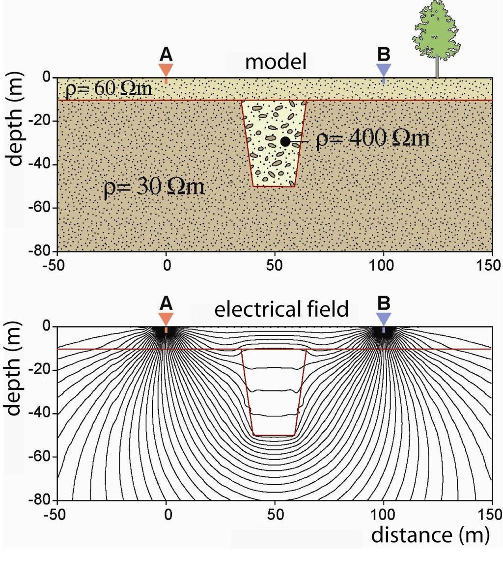
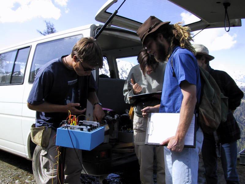
28 Heterogeneous Earth 28

29 Effect of Topography 29
30 3. Survey Strategies and Interpretation 30
31 31
32 32 Two Potential Electrodes NB AN MB AM I V NB AN MB AM I V V V NB AN I V MB AM I V MN a N M MN N M
33 Apparent Resistivity In a heterogeneous medium, the measured resistivity is an apparent resistivity, which is a function of the form of the inhomogeneity and of the electrode spacing and surface location. 33
34 Geometric Factor For a half-space and electrodes on the surface, a general definition for the geometric factor K can be written: a VMN I AM MB AN NB 1 a V I MN K 34
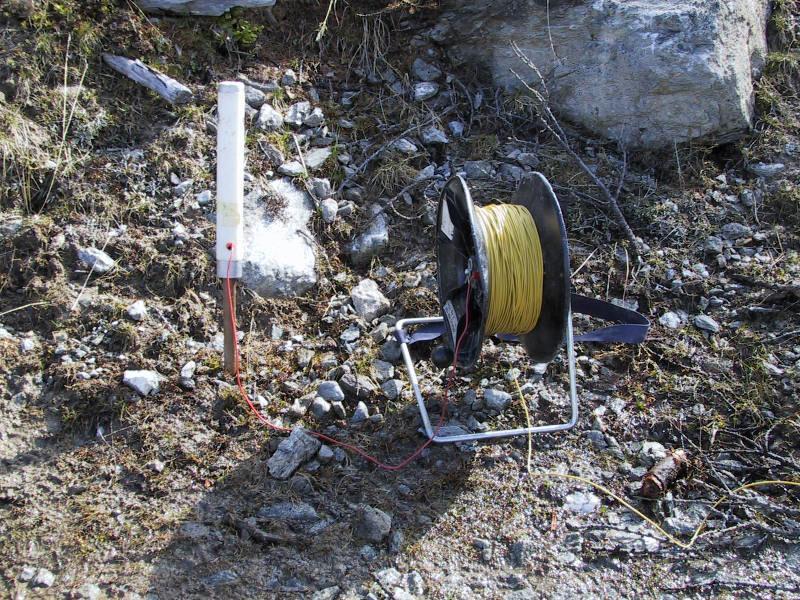
35 Device Current source: batteries in series Voltmeter and ammeter (resistivimeter) Electrodes: metallic stakes current electrodes: stainless steel potential electrodes: stainless steel or nonpolarizing electrodes Polarization occurs at the contact electrode/ground: this creates an additional potential difference. 35
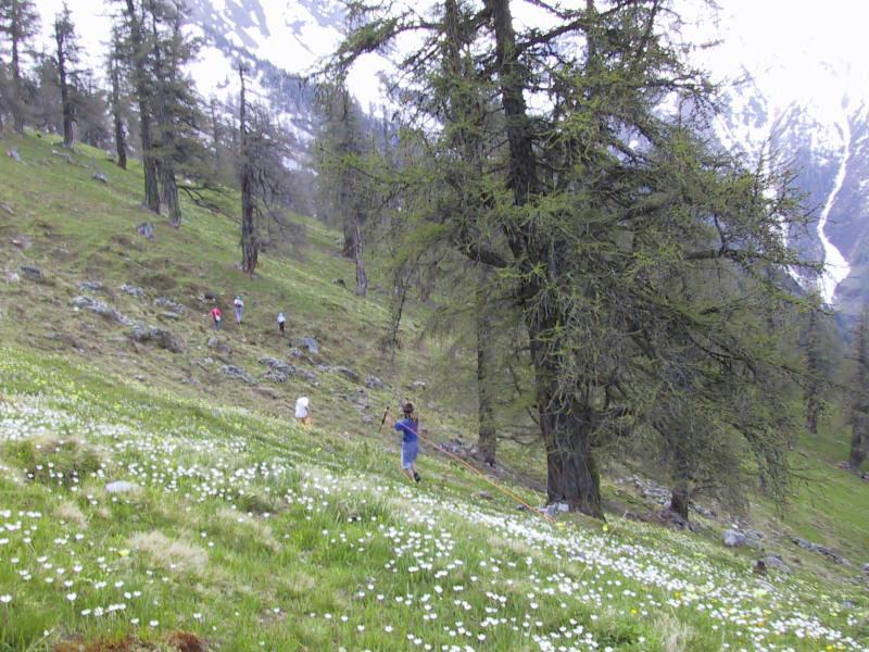
36 To Decrease Contact Resistance Add electrodes in parallel Increase the current intensity Increase the diameter of the current electrodes Put electrode deeper into the ground Add water (with salt) near the electrodes About 90% of the contact resistance contribution comes from a portion of the ground around the electrode that is equal to 10 times the diameter of the electrode 36
37 Origine of Noise Telluric currents Man-made currents Metallic conductors in the ground (short-circuits) Solutions: Use of alternating current Stacking operations Rejection filters (16-20 Hz, Hz) 37
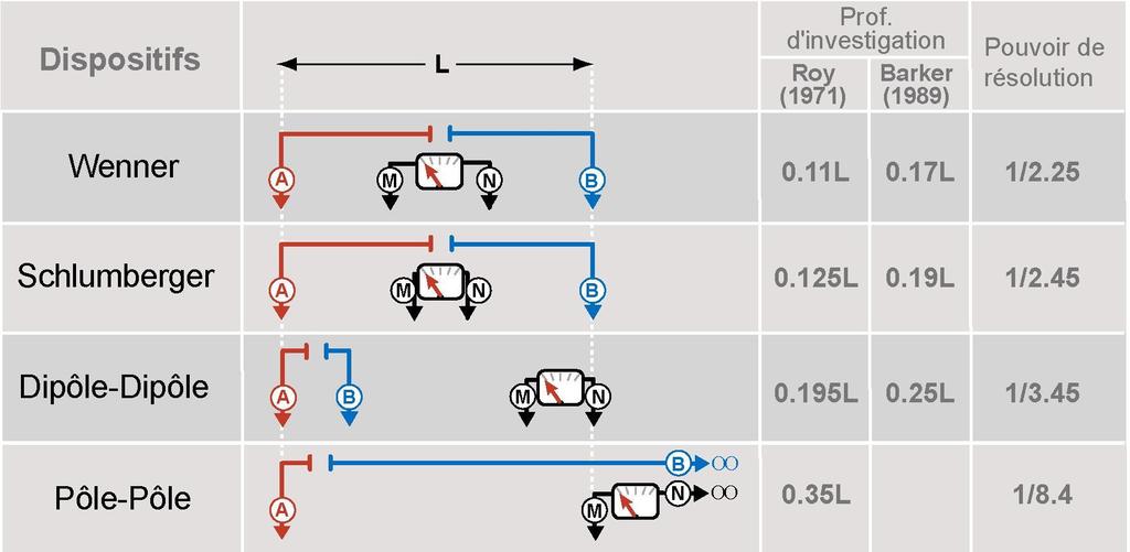
38 Survey Strategies Resistivity mapping, constant separation traversing (CST): used to determine lateral variations of resistivity. The current and potential electrodes are maintained at a fixed separation and moved along profiles Vertical electrical sounding (VES): used in the study of near-horizontal interfaces. The electrode spread is progressively expanded about a central point Electrical Resistivity Tomography (ERT): is a mix between CST and VES. Also named electrical imaging 38
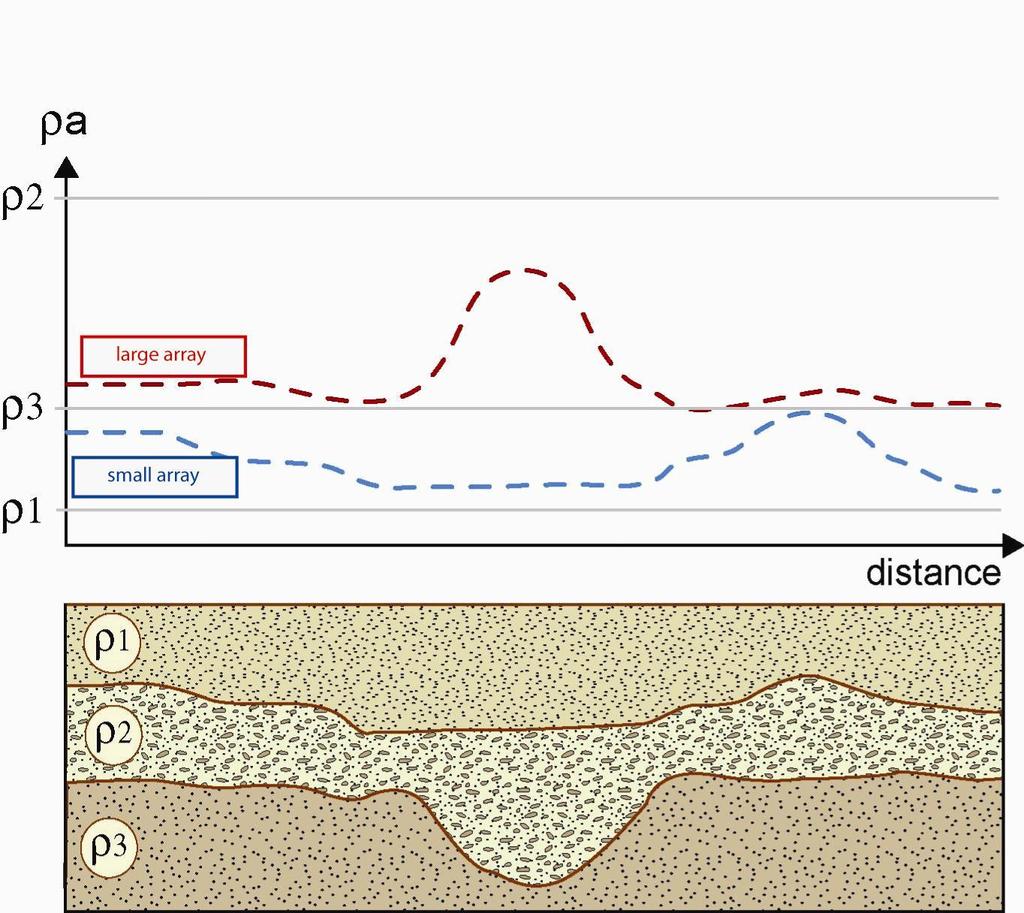
 39")
39 Constant Separation Traversing (CST) 39
40 Constant Separation Traversing (CST) 40
41 Constant Separation Traversing (CST) 41
42 Constant Separation Traversing (CST) 42
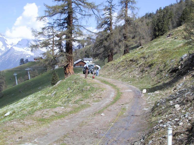
43 Constant Separation Traversing (CST) Demo during the lecture 43
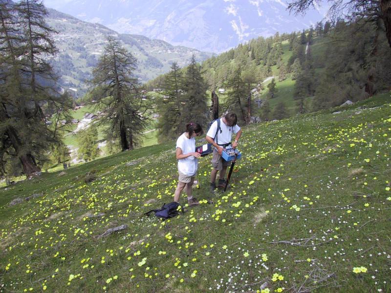
44 Electrode Spreads 44
45 Electrode spreads 2a a V I V a n( n 1) a I Wenner array Schlumberger array a n( n 1)( n 2) a V I dipole-dipole array 45
46 Penetration Depth 46
47 Interpretation of CST 47
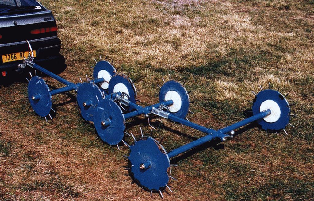
48 48

49 49

50 50
51 51

52 Multiple Twin Probes RM15 resistance meter with multiplexer 52

53 Sanctuary of Poseidon (island of Poros, Greece) Papadopoulos et al., Archeological Prospection, 13,


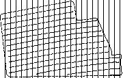
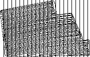
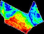
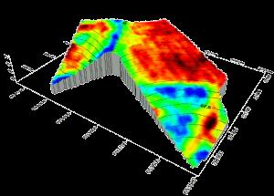
54 Ancient Royal Site of Rathcroghan, Ireland Barton & Fenwick, Archeological Prospection, 12,
 AB=4m wall")
55 Peristyle villa Gallo-romaine Yvonand (Vaud) AB=4m wall fountain? 55

56 Manually Dragged Systems Dabas et al., 2000, Archeological Prospection, 7,
 Dabas et al.")

57 Roman city, Wroxester (UK) Dabas et al., 2000, Archeological Prospection, 7,

58 Mobile Arrays with Vehicle Source: Geocarta, Paris 100 data points/seconde 1 data point each 20cm 58
59 59


60 Mobile Arrays Source: Geocarta, Paris Vineyards investigations 60


61 Mobile Arrays Current injection A B Resistivity measurement (three investigation depths) M2 M1 N1 N2 M3 N3 61 Source: Geocarta, Paris
 Surface: 155")

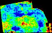
62 Mapping example with mobile array (spacing 2m) Surface: 155 hectares Apparent resistivity 30 ohm.m 160 ohm.m 62 Source: Geocarta, Paris
 Surface: 140")

63 Mapping example with mobile array (spacing 2m) Surface: 140 hectares Apparent resistivity 15 ohm.m 150 ohm.m 63 Source: Geocarta, Paris


64 Profile spacing 6m Profile spacing 12m Profile spacing 24m Apparent resistivity 10 ohm.m 90 ohm.m 64 Source: Geocarta, Paris


65 Ecartement 0.5m Ecartement 1m Ecartement 2m Apparent resistivity 10 ohm.m 60 ohm.m 65 Source: Geocarta, Paris

66 Inaccuracy in Location 66

67 Electrostatic Mobile Arrays 67

68 XVII and XVIII centuries structures (La Rochelle, France) Panissod et al., 1998, Archeological Prospection, 5,
69 Vertical Electrical Sounding (VES) 69

70 Vertical Electrical Sounding (VES) 70
71 Vertical Electrical Sounding (VES) 71
72 Vertical Electrical Sounding (VES) Demo during the lecture 72
73 73
74 One Layer and Two Layers 74
75 75
76 76

77 Three layers and more 77
 Comparison between data A and C and modification of")
78 Interpretation Field data Model Calculated data (response of model B) Comparison between data A and C and modification of model B 78

79 Interpretation of VES Demo during the lecture 79

80 Interpretation of VES 80

81 Equivalence h constant h constant 81
82 Parametric Sounding A parametric sounding is a VES carried out on an outcrop or near a borehole to precisely determine the resistivity of a geological formation. A precise determination of resistivity reduce the problem of equivalence 82
83 Suppression 83
84 84

85 85
86 86

87 87
88 88
89 89
1. Resistivity of rocks
 RESISTIVITY 1) Resistivity of rocks 2) General principles of resistivity surveying 3) Field procedures, interpretation and examples 4) Summary and conclusions INDUCED POLARIZATION 1) General principles
Introduction. Electrical surveying. Resistivity method Induced polarization method (IP) Self-potential (SP) method
 Self-potential (SP) method") Introduction Electrical surveying Resistivity method Induced polarization method (IP) Self-potential (SP) method Higher frequency methods (electromagnetic surveys): Electromagnetic induction methods Ground
Introduction Electrical surveying Resistivity method Induced polarization method (IP) Self-potential (SP) method Higher frequency methods (electromagnetic surveys): Electromagnetic induction methods Ground
Geophysics Course Interpreting DC Resistivity Data
 NORAD supported project in MRRD covering Capacity Building and Institutional Cooperation in the field of Hydrogeology for Faryab Province Afghanistan Geophysics Course Interpreting DC Resistivity Data
Geophysics Course Introduction to DC Resistivity
 NORAD supported project in MRRD covering Capacity Building and Institutional Cooperation in the field of Hydrogeology for Faryab Province Afghanistan Geophysics Course Introduction to DC Resistivity By
Surface and borehole electrical resistivity tomography
 Surface and borehole electrical resistivity tomography Laurent Marescot laurent@tomoquest.com Introduction Surface electrical resistivity surveying is based on the principle that the distribution of electrical
Geoelectricity. ieso 2010
 Geoelectricity ieso 2010 1 RESISTIVITY SURVEY AT VENETO VILLA GRITTI AT THE TOWN OF TREVISO (VENETO REGION) The survey was carried out to verify the underground presence of the fondations of a rustic building.
Geophysics for Environmental and Geotechnical Applications
 Geophysics for Environmental and Geotechnical Applications Dr. Katherine Grote University of Wisconsin Eau Claire Why Use Geophysics? Improve the quality of site characterization (higher resolution and
GLE 594: An introduction to applied geophysics
 GLE 594: An introduction to applied geophysics Electrical Resistivity Methods Fall 2004 Earth Properties and Basic Theory Reading Today : 207-218 Next Lecture : 218-228 1 Introduction Link resistivity
Seismic Surveying. Dr. Laurent Marescot. Course given at the University of Fribourg (2009) Contact:
 Contact:") Seismic Surveying Dr. Laurent Marescot Course given at the University of Fribourg (2009) Contact: laurent@tomoquest.com 1 Introduction Seismic surveying Investigation based on the propagation of man-made
Seismic Surveying Dr. Laurent Marescot Course given at the University of Fribourg (2009) Contact: laurent@tomoquest.com 1 Introduction Seismic surveying Investigation based on the propagation of man-made
Electrical Methods. Resistivity Surveying
 Electrical Methods Resistivity Surveying Geologic Resistivity 1101 Resistivity surveying investigates variations of electrical resistance, by causing an electrical current to flow through the subsurface
CONTENTS 1. INTRODUCTION. 2. THE D.C. RESISTIVITY METHOD 2.1 Equipment 2.2 Survey Procedure 2.3 Data Reduction
 (i) CONTENTS 1. INTRODUCTION page 1 2. THE D.C. RESISTIVITY METHOD 2.1 Equipment 2.2 Survey Procedure 2.3 Data Reduction 3 3 3 3 3. GEOPHYSICAL RESULTS 3.1 General 3.2 Discussion 4 4 4 4. LIMITATIONS 5
Electrical prospecting involves detection of surface effects produced by electrical current flow in the ground.
 Electrical Surveys in Geophysics Electrical prospecting involves detection of surface effects produced by electrical current flow in the ground. Electrical resistivity method Induced polarization (IP)
Geology 228/378 Applied and Environmental Geophysics Lecture 6. DC resistivity Surveys
 Geology 228/378 Applied and Environmental Geophysics Lecture 6 DC resistivity Surveys Direct current (DC) Resistivity. Introduction 2. Current flow in the ground 3. Schlumberger, Wenner, dipole-dipole,
Electrical imaging techniques for hydrological and risk assessment studies
 Séminaire IPG le 9 mars 2006 Strasbourg Institute of Geophysics ETH Hoenggerberg CH-8093 Zurich Electrical imaging techniques for hydrological and risk assessment studies Laurent Marescot laurent@aug.ig.erdw.ethz.ch
ELECTRICAL RESISTIVITY TOMOGRAPHY
 NOTIO Association Clay Technological Centre C/ Río Cabriel s/n 45007 Toledo Tel.: 925 24 11 62 info@notio.es www.notio.es Page 1 / 7 SUMMARY 1. PHYSICAL FUNDAMENTALS OF THE... 3 1.1. ELECTRICAL BEHAVIOR
Site Characterization & Hydrogeophysics
 Site Characterization & Hydrogeophysics (Source: Matthew Becker, California State University) Site Characterization Definition: quantitative description of the hydraulic, geologic, and chemical properties
APPLICATION OF ELECTRICAL RESISTIVITY TOMOGRAPHY FOR SAND UNDERWATER EXTRACTION
 International Scientific Conference GEOBALCANICA 2018 APPLICATION OF ELECTRICAL RESISTIVITY TOMOGRAPHY FOR SAND UNDERWATER EXTRACTION Maya Grigorova Ivaylo Koprev University of Mining and Geology St. Ivan
Resistivity & IP methods
 International PhD Course in HYDROGEOPHYSICS Resistivity & IP methods Andrew Binley Lancaster University Overview We have demonstrated links between hydrological and geophysical properties and show the
2-D Resistivity Study: The Horizontal Resolution Improvement by Introducing the Enhancing Horizontal Resolution (EHR) Technique
 Technique") Open Journal of Geology, 213, 3, 1-6 doi:1.4236/ojg.213.32b1 Published Online April 213 (http://www.scirp.org/journal/ojg) 2-D Resistivity Study: The Horizontal Resolution Improvement by Introducing the
Open Journal of Geology, 213, 3, 1-6 doi:1.4236/ojg.213.32b1 Published Online April 213 (http://www.scirp.org/journal/ojg) 2-D Resistivity Study: The Horizontal Resolution Improvement by Introducing the
ELECTRICAL PROSPECTING METHODS
 Suez Canal University Faculty of Science Department of Geology ELECTRICAL PROSPECTING METHODS Prepared By El-Arabi Hendi Shendi Professor of applied & environmental Geophysics 2008 1 CONTENTS Definitions
MOUNT POLLEY MINING CORPORATION TECHNICAL REPORT ON MULTI-ELECTRODE RESISTIVITY AND SEISMIC REFRACTION SURVEYS MOUNT POLLEY TAILINGS DAM PROJECT
 MOUNT PLEY MINING CORPORATION TECHNICAL REPORT ON MULTI-ELECTRODE RESISTIVITY AND SEISMIC REFRACTION SURVEYS MOUNT PLEY TAILINGS DAM PROJECT LIKELY, B.C. by Claudia Krumbiegel, M.Sc. Cliff Candy, P.Geo.
Part II: Self Potential Method and Induced Polarization (IP)
") Part II: Self Potential Method and Induced Polarization (IP) Self-potential method (passive) Self-potential mechanism Measurement of self potentials and interpretation Induced polarization method (active)
Part II: Self Potential Method and Induced Polarization (IP) Self-potential method (passive) Self-potential mechanism Measurement of self potentials and interpretation Induced polarization method (active)
Definition. Useful References
 Introduction to Geophysics Short Course Assignments http://www.mines.edu/fs_home/tboyd/gp311/modules/res/main.html Definition Resistivity Method - Observation of electric fields caused by current introduced
LECTURE 10. Module 3 : Field Tests in Rock 3.6 GEOPHYSICAL INVESTIGATION
 LECTURE 10 3.6 GEOPHYSICAL INVESTIGATION In geophysical methods of site investigation, the application of the principles of physics are used to the study of the ground. The soil/rock have different characteristics
An Introduction to Applied and Environmental Geophysics
 An to Applied and Environmental Geophysics 2nd Edition John M. Reynolds Reynolds International Ltd Preface to the 2 na Edition Acknowledgements 1 1.1 1.2 1.3 1.4 1.5 What are 'applied' and 'environmental'
GY 402: Sedimentary Petrology
 UNIVERSITY OF SOUTH ALABAMA GY 402: Sedimentary Petrology Lecture 27: Introduction to Wireline Log Interpretations Instructor: Dr. Douglas W. Haywick Last Time Carbonate Diagenesis Diagenesis 0.5 mm PPL
So I have a Seismic Image, But what is in that Image?
 P-513 So I have a Seismic Image, But what is in that Image? Dr. Nader C. Dutta, Schlumberger Introduction and background Migration involves repositioning of returned signals in a seismic experiment to
INTRODUCTION TO APPLIED GEOPHYSICS
 INTRODUCTION TO APPLIED GEOPHYSICS EXPLORING THE SHALL0W SUBSURFACE H. Robert Burger Anne F. Sheehan Craig H.Jones VERSITY OF COLORADO VERSITY OF COLORADO W. W. NORTON & COMPANY NEW YORK LONDON Contents
Hydrological geophysical relationships
 International PhD Course in HYDROGEOPHYSICS Hydrological geophysical relationships Andrew Binley Lancaster University Overview In the course we will concentrate on electrical, electromagnetic and radar
Summary. Introduction
 Effect of over- and under-burden on time-lapse CSEM monitoring capabilities Arash JafarGandomi* and Andrew Curtis, School of GeoSciences, The University of Edinburgh, Kings Buildings, Edinburgh EH9 3JW,
GPR profiling and electrical resistivity tomography for buried cavity detection: a test site at the Abbaye de l'ouye (France)
") GPR profiling and electrical resistivity tomography for buried cavity detection: a test site at the Abbaye de l'ouye (France) Nerouz BOUBAKI, Albane SAINTENOY, Piotr TUCHOLKA IDES - UMR 8148 CNRS, Université
GPR profiling and electrical resistivity tomography for buried cavity detection: a test site at the Abbaye de l'ouye (France) Nerouz BOUBAKI, Albane SAINTENOY, Piotr TUCHOLKA IDES - UMR 8148 CNRS, Université
Well Logging. Salam Al Rbeawi 2011
 Well Logging Salam Al Rbeawi 2011 Well Logging: Is a technique used for formation evaluation to determine the size of the reservoir and the amount of oil and gas in place. The following parameters can
Groundwater Sustainability at Wadi Al Bih Dam, Ras El Khaimah, United Arab Emirates (UAE) using Geophysical methods
 using Geophysical methods") Groundwater Sustainability at Wadi Al Bih Dam, Ras El Khaimah, United Arab Emirates (UAE) using Geophysical methods Ahmed Murad, Amir Gabr, Saber Mahmoud, Hasan Arman & Abdulla Al Dhuhoori Geology Department
Groundwater Sustainability at Wadi Al Bih Dam, Ras El Khaimah, United Arab Emirates (UAE) using Geophysical methods Ahmed Murad, Amir Gabr, Saber Mahmoud, Hasan Arman & Abdulla Al Dhuhoori Geology Department
Analysis of electrical resistivity data for the determination of aquifer depth at Sapele RD in Benin city
 Available online at www.pelagiaresearchlibrary.com Advances in Applied Science Research, 203, 4(6):268-276 ISSN: 0976-860 CODEN (USA): AASRFC Analysis of electrical resistivity data for the determination
LIST OF FIGURES APPENDICES
 RESISTIVITY / INDUCED POLARIZATION SURVEY EL PORVENIR PROJECT MUNICIPALITY OF REMEDIOS, ANTIOQUIA, COLOMBIA LOGISTICS REPORT M-17427 APRIL 2017 TABLE OF CONTENTS Abstract... 1 1. The Mandate... 2 2. El
Lesson 2 Geophysical methods for rock mass characterization Emanuele Forte
 Lesson 2 Geophysical methods for rock mass characterization Emanuele Forte 3 rd September 2016 Naxos, Greece Outline Review of geophysical methods and their applicability to rock mass characterization:
CHARACTERIZATION OF SOIL PROFILE OF DHAKA CITY USING ELECTRICAL RESISTIVITY TOMOGRAPHY (ERT)
") CHARACTERIZATION OF SOIL PROFILE OF DHAKA CITY USING ELECTRICAL RESISTIVITY TOMOGRAPHY (ERT) Mehedi Ahmed ANSARY 1, B.S. Pushpendue BISWAS 2 and Abul KHAIR 3 1 Professor, Department of Civil Engineering
CHARACTERIZATION OF SOIL PROFILE OF DHAKA CITY USING ELECTRICAL RESISTIVITY TOMOGRAPHY (ERT) Mehedi Ahmed ANSARY 1, B.S. Pushpendue BISWAS 2 and Abul KHAIR 3 1 Professor, Department of Civil Engineering
EXTREMELY FAST IP USED TO DELINEATE BURIED LANDFILLS. Norman R. Carlson, Cris Mauldin Mayerle, and Kenneth L. Zonge
 EXTREMELY FAST IP USED TO DELINEATE BURIED LANDFILLS Norman R. Carlson, Cris Mauldin Mayerle, and Kenneth L. Zonge Zonge Engineering and Research Organization, Inc. 3322 East Fort Lowell Road Tucson, Arizona,
ambiguity in earth sciences IESO Geophysics Section Eddy hartantyo, Lab Geofisika FMIPA UGM
 ambiguity in earth sciences IESO Geophysics Section Eddy hartantyo, Lab Geofisika FMIPA UGM Pelatihan Tahap II IESO Teknik Geologi UGM Februari 2009 1 Introduction Photos from http://www.eegs.org/whatis/
Case Study: University of Connecticut (UConn) Landfill
 Landfill") Case Study: University of Connecticut (UConn) Landfill Problem Statement:» Locate disposal trenches» Identify geologic features and distinguish them from leachate and locate preferential pathways in fractured
Case Study: University of Connecticut (UConn) Landfill Problem Statement:» Locate disposal trenches» Identify geologic features and distinguish them from leachate and locate preferential pathways in fractured
Relevance of 2D Electrical Imaging in Subsurface Mapping: Case Study of National Animal Production Research Institute (NAPRI), Zaria.
, Zaria.") Relevance of 2D Electrical Imaging in Subsurface Mapping: Case Study of National Animal Production Research Institute (NAPRI), Zaria. S.I. Fadele, Ph.D. (in view) 1* ; J. Adamu, M.Sc. 2 ; N.O. Patrick,
Relevance of 2D Electrical Imaging in Subsurface Mapping: Case Study of National Animal Production Research Institute (NAPRI), Zaria. S.I. Fadele, Ph.D. (in view) 1* ; J. Adamu, M.Sc. 2 ; N.O. Patrick,
Improved Exploration, Appraisal and Production Monitoring with Multi-Transient EM Solutions
 Improved Exploration, Appraisal and Production Monitoring with Multi-Transient EM Solutions Folke Engelmark* PGS Multi-Transient EM, Asia-Pacific, Singapore folke.engelmark@pgs.com Summary Successful as
OWNER OPERATOR: BLACKWATER EXPLORATIONS LTD. REPORT ON RESISTIVITY PROFILING SURVEY PLACER GOLD EXPLORATION
 OWNER OPERATOR: BLACKWATER EXPLORATIONS LTD. REPORT ON RESISTIVITY PROFILING SURVEY PLACER GOLD EXPLORATION CARIBOO MINING DISTRICT NTS 93G CLAIM PC682023 Latitude 53 13 35.64 Longitude 122 49 40.65 by
Geophysics of Exploration for Water. Geoelectric methods III. edited by Peter Vass
 Geophysics of Exploration for Water Geoelectric methods III edited by Peter Vass The phenomenon of induced polarization was already noticed at the early stage of applying direct current electrical methods
EOSC252 - Exercise 9
 Name: 1. Introduction EOSC252 - Exercise 9 Dielectric properties This is really nothing more than a multiple choice / short answer quiz-style assignment. You will need to have done the readings about dielectric
The Use of Vertical Electrical Sounding (VES) for Subsurface Geophysical Investigation around Bomo Area, Kaduna State, Nigeria
 for Subsurface Geophysical Investigation around Bomo Area, Kaduna State, Nigeria") IOSR Journal of Engineering (IOSRJEN) e-issn: 2250-3021, p-issn: 2278-8719 Vol. 3, Issue 1 (Jan. 2013), V4 PP 10-15 The Use of Vertical Electrical Sounding (VES) for Subsurface Geophysical Investigation
IOSR Journal of Engineering (IOSRJEN) e-issn: 2250-3021, p-issn: 2278-8719 Vol. 3, Issue 1 (Jan. 2013), V4 PP 10-15 The Use of Vertical Electrical Sounding (VES) for Subsurface Geophysical Investigation
LITTLE ABOUT BASIC PETROPHYSICS
 LITTLE ABOUT BASIC PETROPHYSICS Author: MUHAMMAD ZAHID M.Sc (Applied Geology) Specialization in Petrophysics University of Azad Jammu & Kashmir, Muzaffarabad. ENTER Introduction - Determination of Physical
INTEGRATED INVESTIGATION TO LOCATE A WASTE DISPOSAL AREA
 INTEGRATED INVESTIGATION TO LOCATE A WASTE DISPOSAL AREA 1 FOR OIL DRILLING PRODUCTS G. APOSTOLOPOULOS 2, K. PAVLOPOULOS 3, C. ANTONIADES 4, I. LOUIS 5 and C. VLACHOU 4 Nestoros 1, 17564 P.Faliron, Athens,
A Case Study of High-Resolution Gravity and Wenner-Schlumberger Resistivity for Geotechnical Engineering: An Example from North Jordan
 Research Journal of Applied Sciences, Engineering and Technology 5(4): 1377-1382-, 2013 ISSN: 2040-7459; e-issn: 2040-7467 Maxwell Scientific Organization, 2013 Submitted: July 09, 2012 Accepted: August
KARST MAPPING WITH GEOPHYSICS AT MYSTERY CAVE STATE PARK, MINNESOTA
 KARST MAPPING WITH GEOPHYSICS AT MYSTERY CAVE STATE PARK, MINNESOTA By Todd A. Petersen and James A. Berg Geophysics Program Ground Water and Climatology Section DNR Waters June 2001 1.0 Summary A new
B7 Applications of DC resistivity exploration
 B7 Applications of DC resistivity exploration Modern DC resistivity surveys collect data for generating a 2-D or 3-D geoelectric model of the Earth. A simple 1-D analysis does not often yield results that
Geophysical mapping and imaging of soil structures: basic overview
 Geophysical mapping and imaging of soil structures: basic overview Stéphane Garambois Landslide team, LGIT, Université Joseph Fourier 3D imaging of the water table (seismic) Geophysical methods 1 Plan
INTRODUCTION TO LOGGING TOOLS
 BY: MUHAMMAD ZAHID INTRODUCTION TO LOGGING TOOLS 1- SPONTANEOUS POTENTIAL (SP) The Spontaneous potential survey, (sp) was one of the first measurements, which was carried out, in a well bore. The SP log
DETECTION OF GROUNDWATER POLLUTION USING RESISTIVITY IMAGING AT SERI PETALING LANDFILL, MALAYSIA
 JOURNAL OF ENVIRONMENTAL HYDROLOGY The Electronic Journal of the International Association for Environmental Hydrology On the World Wide Web at http://www.hydroweb.com VOLUME 8 2000 DETECTION OF GROUNDWATER
4 Hydro-geophysical methods. 3.2 Technical meetings. 3.3 Additional investigations
 the geological context: outcrops, tilts, directions of identified fractures, profiles observed in wells etc.; the geomorphological context: relief, hydrographic network, potential infiltration zones, floodable
Hamed Aber 1 : Islamic Azad University, Science and Research branch, Tehran, Iran. Mir Sattar Meshin chi asl 2 :
 Present a Proper Pattern for Choose Best Electrode Array Based on Geological Structure Investigating in Geoelectrical Tomography, in order to Get the Highest Resolution Image of the Subsurface Hamed Aber
GEO4270 EXERCISE 2 PROSPECT EVALUATION
 GEO4270 EXERCISE 2 PROSPECT EVALUATION GEO4270 Integrated Basin Analysis and Prospect Evaluation 1. Integrated Seismic (reflection/refraction), Gravity and Magnetics and Basin Modelling Large Scale Structures
S.I. Fadele, M.Sc. 1 ; P.O. Sule, Ph.D. 1 ; and B.B.M. Dewu, Ph.D * ABSTRACT
 The Use of Vertical Electrical Sounding (VES) for Groundwater Exploration around Nigerian College of Aviation Technology (NCAT), Zaria, Kaduna State, Nigeria. S.I. Fadele, M.Sc. 1 ; P.O. Sule, Ph.D. 1
COPYRIGHT PETROSKILLS LLC
 RESISTIVITY LOGGING AND INTERPRETATION CORE Invasion and the Borehole Environment Part 1 LEARNING OBJECTIVES By the end of this lesson, you will be able to: Explain mud filtrate invasion and describe the
OPERATIVE GUIDE INDUCED POLARIZATION
 OPERATIVE GUIDE INDUCED POLARIZATION 1 Induced polarization geoelectric procedure Generals Induced polarization (capacitive effect) represents attitude of a material to collect electric charges of opposite
Module for: Resistivity Theory (adapted/modified from lectures in PETE 321 (Jensen/Ayers))
)") (PETE 663 Formation Evaluation and the Analysis of Reservoir Performance (Fall 2003)) Module for: Resistivity Theory (adapted/modified from lectures in PETE 321 (Jensen/Ayers)) J. L. Jensen W.B. Ayers
(PETE 663 Formation Evaluation and the Analysis of Reservoir Performance (Fall 2003)) Module for: Resistivity Theory (adapted/modified from lectures in PETE 321 (Jensen/Ayers)) J. L. Jensen W.B. Ayers
Vertical electrical sounding (VES) for subsurface geophysical investigation in Kanigiri area, Prakasam district, Andhra Pradesh, India
 for subsurface geophysical investigation in Kanigiri area, Prakasam district, Andhra Pradesh, India") Available online at www.pelagiaresearchlibrary.com Advances in Applied Science Research, 2014, 5(5):82-86 ISSN: 0976-8610 CODEN (USA): AASRFC Vertical electrical sounding (VES) for subsurface geophysical
Available online at www.pelagiaresearchlibrary.com Advances in Applied Science Research, 2014, 5(5):82-86 ISSN: 0976-8610 CODEN (USA): AASRFC Vertical electrical sounding (VES) for subsurface geophysical
water L v i Chapter 4 Saturation
 4. Resistivity The presence of hydrocarbons is identified by the electrical resistance of the formation. These electrical properties of rocks depend on the pore geometry and fluid distribution. That is,
4.6 DC resistivity and IP field systems, data processing and interpretation
 4.6 DC resistivity and P field systems, data processing and interpretation Electrode arrays Response of a layered earth The anisotropic half space Response of simple inhomogeneities Solutions for arbitrary
GLG 471; MICHIGAN STATE UNIVERSITY INSTRUCTOR R.L. VAN DAM PROJECT: ELECTRICAL RESISTIVITY
 GLG 471; MICHIGAN STATE UNIVERSITY INSTRUCTOR R.L. VAN DAM PROJECT: ELECTRICAL RESISTIVITY General information: This is a group (2-3 students) project requiring lab-, computer-, and fieldwork. Work will
2-D RESISTIVITY IMAGING SURVEY FOR WATER-SUPPLY TUBE WELLS IN A BASEMENT COMPLEX: A CASE STUDY OF OOU CAMPUS, AGO-IWOYE SW NIGERIA
 2-D RESISTIVITY IMAGING SURVEY FOR WATER-SUPPLY TUBE WELLS IN A BASEMENT COMPLEX: A CASE STUDY OF OOU CAMPUS, AGO-IWOYE SW NIGERIA 1 AYOLABI, Elijah Adebowale. 2 FOLORUNSO, Adetayo Femi. and 3 ARIYO, Stephen
Geophysical Applications GPR Ground Penetrating Radar
 Overview: Basics of GPR Radar-wave velocity, attenuation and skin depth Modes of acquisition The Radar-range equation Dielectric properties of materials and relation to porosity Case studies [Archeology,
Magnetotelluric (MT) Method
 Method") Magnetotelluric (MT) Method Dr. Hendra Grandis Graduate Program in Applied Geophysics Faculty of Mining and Petroleum Engineering ITB Geophysical Methods Techniques applying physical laws (or theory) to
Magnetotelluric (MT) Method Dr. Hendra Grandis Graduate Program in Applied Geophysics Faculty of Mining and Petroleum Engineering ITB Geophysical Methods Techniques applying physical laws (or theory) to
MT Prospecting. Map Resistivity. Determine Formations. Determine Structure. Targeted Drilling
 MT Prospecting Map Resistivity Determine Formations Determine Structure Targeted Drilling Cross-sectional interpretation before and after an MT survey of a mineral exploration prospect containing volcanic
Prof. Stephen A. Nelson EENS 111. Groundwater
 Page 1 of 8 Prof. Stephen A. Nelson EENS 111 Tulane University Physical Geology This page last updated on 20-Oct-2003 is water that exists in the pore spaces and fractures in rock and sediment beneath
INVESTIGATION ON THE EFFECT OF STRESS ON CEMENTATION FACTOR OF IRANIAN CARBONATE OIL RESERVOIR ROCKS
 SCA4-41 1/7 INVESTIGATION ON THE EFFECT OF STRESS ON CEMENTATION FACTOR OF IRANIAN CARBONATE OIL RESERVOIR ROCKS R. Behin, RIPI, NIOC This paper was prepared for presentation at the International Symposium
An Introduction to Geophysical Exploration
 An Introduction to Geophysical Exploration Philip Kearey Department of Earth Sciences University of Bristol Michael Brooks Ty Newydd, City Near Cowbridge Vale of Glamorgan Ian Hill Department of Geology
Coal Layer Identification using Electrical Resistivity Imaging Method in Sinjai Area South Sulawesi
 Journal of Physics: Conference Series PAPER OPEN ACCESS Coal Layer Identification using Electrical Resistivity Imaging Method in Sinjai Area South Sulawesi To cite this article: Andi Ilham Samanlangi 2018
GEOELECTRICAL STUDY FOR DELINEATING UNDERGROUND CAVITIES IN KARST AREAS
 GEOELECTRICAL STUDY FOR DELINEATING UNDERGROUND CAVITIES IN KARST AREAS Vl a d Rădulescu (1), Fl o r i a n Rădulescu (2), Co n s t a nt i n Diacopolos (3), Ma r i a n Popescu (3) (1) National Institute
Archaeological Prospecting using Electric and Electrostatic Mobile Arrays
 Archaeological Prospection Archaeol. Prospect. 5, 239±251 (1998) Archaeological Prospecting using Electric and Electrostatic Mobile Arrays C. PANISSOD 1 *, M. DABAS 3, N. FLORSCH 2, A. HESSE 3, A. JOLIVET
Study on the Four- property Relationship of Reservoirs in YK Area of Ganguyi Oilfield
 Study on the Four- property elationship of eservoirs in YK Area of Ganguyi Oilfield Abstract Xinhu Li, Yingrun Shang Xi an University of Science and Technology, Xi an 710054, China. shangyingrun@163.com
2D Electrical Resistivity Tomography survey optimisation of solute transport in porous media
 ArcheoSciences Revue d'archéométrie 33 (suppl.) 2009 Mémoire du sol, espace des hommes 2D Electrical Resistivity Tomography survey optimisation of solute transport in porous media Gregory Lekmine, Marc
Permeability Estimates & Saturation Height Functions: A talk of two halves. Dr Joanne Tudge LPS Petrophysics 101 Seminar 17 th March 2016
 Permeability Estimates & Saturation Height Functions: A talk of two halves Dr Joanne Tudge LPS Petrophysics 101 Seminar 17 th March 2016 Permeability: What is it? How do we measure it? Why do we need it?
Variation of Moisture Content as a Parameter of Study by Induced Polarization Technique in Soil Sample of Coastal Andhra Pradesh
 Cloud Publications International Journal of Advanced Civil Engineering and Architecture Research 2012, Volume 1, Issue 1, pp. 1-5, Article ID Tech-27 Research Article Open Access Variation of Moisture
Chapter 4 Influences of Compositional, Structural and Environmental Factors on. Soil EM Properties
 Chapter 4 Influences of Compositional, Structural and Environmental Factors on Soil EM Properties 4. 1 Introduction The measured soil electromagnetic properties can be affected by a large number of factors
3. Magnetic Methods / 62
 Contents Preface to the Second Edition / xv Excerpts from Preface to the FirstEdition / xvii Mathematical Conventions / xix 1. Introduction / 1 Reference / 5 2. Gravity Methods / 6 2. I. Introduction /
FINAL REPORT GEOPHYSICAL INVESTIGATION VILLAGE ALHAMBRA RETENTION POND SITE THE VILLAGES, FLORIDA
 FINAL REPORT GEOPHYSICAL INVESTIGATION VILLAGE ALHAMBRA RETENTION POND SITE THE VILLAGES, FLORIDA Prepared for Andreyev Engineering, Inc. Oxford, FL Prepared by GeoView, Inc. St. Petersburg, FL August
DOWN-HOLE SEISMIC SURVEY AND VERTICAL ELECTRIC SOUNDINGS RABASKA PROJECT, LÉVIS, QUÉBEC. Presented to :
 DOWN-HOLE SEISMIC SURVEY AND VERTICAL ELECTRIC SOUNDINGS RABASKA PROJECT, LÉVIS, QUÉBEC Presented to : TERRATECH 455, René-Lévesque Blvd. West Montreal, Québec HZ 1Z3 Presented by : GEOPHYSICS GPR INTERNATIONAL
Principles of Applied Geophysics
 Principles of Applied Geophysics Fifth edition D.S. Parasnis Professor emeritus of Applied Geophysics Department of Applied Geophysics, University ofluled, Lulea, Sweden Fellow of the Royal Swedish Academy
Geology 228/378 Applied & Environmental Geophysics Lecture 8. Induced Polarization (IP) and Nuclear Magnetic Resonance (NMR)
 and Nuclear Magnetic Resonance (NMR)") Geology 228/378 Applied & Environmental Geophysics Lecture 8 Induced Polarization (IP) and Nuclear Magnetic Resonance (NMR) Induced Polarization (IP) and Nuclear Magnetic Resonance (NMR) 1. Time domain
Geology 228/378 Applied & Environmental Geophysics Lecture 8 Induced Polarization (IP) and Nuclear Magnetic Resonance (NMR) Induced Polarization (IP) and Nuclear Magnetic Resonance (NMR) 1. Time domain
Received 12 February 2010 Accepted 25 March Abstract. Keywords: sounding resistivity, gem-bearing gravel layer, Wenner, Schlumberger
 One Dimensional Resistivity Sounding for Resolving Gem-bearing Gravel Layer: A Comparison of Schlumberger with Wenner Techniques at Bo Rai, Eastern Thailand Piyaphong Chenrai 1, Punya Charusiri 1* and
RESISTIVITY IMAGING AND BOREHOLE INVESTIGATION OF THE BANTING AREA AQUIFER, SELANGOR, MALAYSIA. A.N. Ibrahim Z.Z.T. Harith M.N.M.
 JOURNAL OF ENVIRONMENTAL HYDROLOGY The Electronic Journal of the International Association for Environmental Hydrology On the World Wide Web at http://www.hydroweb.com VOLUME 11 2003 RESISTIVITY IMAGING
Determining the Relationship between Resistivity, Water and Hydrocarbon Saturation of Rock Formation Using Composite Well Logs
 Determining the Relationship between Resistivity, Water and Hydrocarbon Saturation of Rock Formation Using Composite Well Logs Doi:10.5901/ajis.2013.v2n13p119 Absract Mamudu Afizu Department of Physics,
We N Geophysical Near-surface Characterization for Static Corrections: Multi-physics Survey in Reggane Field, Algeria
 We N114 01 Geophysical Near-surface Characterization for Static Corrections: Multi-physics Survey in Reggane Field, Algeria A. Pineda* (Repsol), S. Gallo (CGG) & H. Harkas (GRN Sonatrach) SUMMARY We are
Subsurface Characterization using Electrical Resistivity(Dipole-Dipole) method at Lagos State University (LASU) Foundation School, Badagry
 method at Lagos State University (LASU) Foundation School, Badagry") Available online at www.pelagiaresearchlibrary.com Advances in Applied Science Research, 2010, 1 (1): 174-181 Subsurface Characterization using Electrical Resistivity(Dipole-Dipole) method at Lagos State
Available online at www.pelagiaresearchlibrary.com Advances in Applied Science Research, 2010, 1 (1): 174-181 Subsurface Characterization using Electrical Resistivity(Dipole-Dipole) method at Lagos State
Geoelectrical characterization for liquefaction at coastal zone in South Aceh
 Geoelectrical characterization for liquefaction at coastal zone in South Aceh Muhammad Syukri Laboratory of Geophysics, Department of Physics, Faculty of Mathematic and Sciences, Syiah Kuala University.
Appendix B: Geophysical Data (Thesis Appendix, 2013)
") Utah State University From the SelectedWorks of David J Richey 2013 Appendix B: Geophysical Data (Thesis Appendix, 2013) David J Richey, Utah State University Available at: https://works.bepress.com/david_richey/2/
Utah State University From the SelectedWorks of David J Richey 2013 Appendix B: Geophysical Data (Thesis Appendix, 2013) David J Richey, Utah State University Available at: https://works.bepress.com/david_richey/2/
Ewumi T.O Department of Physics, Ekiti State University, Ekiti, Nigeria
 A Vertical Electrical Sounding Method For Investigating The Electrical Resistivity, & Salt Content (Salinity) In The Soils Of Sites Proximal To Lekki Peninsula, Lagos. Ewumi T.O Department of Physics,
MUDLOGGING, CORING, AND CASED HOLE LOGGING BASICS COPYRIGHT. Coring Operations Basics. By the end of this lesson, you will be able to:
 LEARNING OBJECTIVES MUDLOGGING, CORING, AND CASED HOLE LOGGING BASICS Coring Operations Basics By the end of this lesson, you will be able to: Understand why cores are justified and who needs core data
3D resistivity imaging of buried tombs at the Parion necropolis (NW Turkey)
") JOURNAL OF THE BALKAN GEOPHYSICAL SOCIETY, Vol. 10, No. 2, December 2007, p. 1-8, 8 figs. 3D resistivity imaging of buried tombs at the Parion necropolis (NW Turkey) Yunus L. Ekinci (1,+) and Mehmet A.
JOURNAL OF THE BALKAN GEOPHYSICAL SOCIETY, Vol. 10, No. 2, December 2007, p. 1-8, 8 figs. 3D resistivity imaging of buried tombs at the Parion necropolis (NW Turkey) Yunus L. Ekinci (1,+) and Mehmet A.
Reservoir Rock Properties COPYRIGHT. Sources and Seals Porosity and Permeability. This section will cover the following learning objectives:
 Learning Objectives Reservoir Rock Properties Core Sources and Seals Porosity and Permeability This section will cover the following learning objectives: Explain why petroleum fluids are found in underground
The Efficacy of Enhancing Horizontal Resolution (EHR) Technique in Shallow Subsurface Study Using 2D Resistivity Method at Bukit Bunuh
 Technique in Shallow Subsurface Study Using 2D Resistivity Method at Bukit Bunuh") 212 International Conference on Geological and Environmental Sciences IPCBEE vol.3 6(212) (212)IACSIT Press, Singapoore The Efficacy of Enhancing Horizontal Resolution (EHR) Technique in Shallow Subsurface
212 International Conference on Geological and Environmental Sciences IPCBEE vol.3 6(212) (212)IACSIT Press, Singapoore The Efficacy of Enhancing Horizontal Resolution (EHR) Technique in Shallow Subsurface
POTASH DRAGON CHILE GEOPHYSICAL SURVEY TRANSIENT ELECTROMAGNETIC (TEM) METHOD. LLAMARA and SOLIDA PROJECTS SALAR DE LLAMARA, IQUIQUE, REGION I, CHILE
 METHOD. LLAMARA and SOLIDA PROJECTS SALAR DE LLAMARA, IQUIQUE, REGION I, CHILE") POTASH DRAGON CHILE GEOPHYSICAL SURVEY TRANSIENT ELECTROMAGNETIC (TEM) METHOD LLAMARA and SOLIDA PROJECTS SALAR DE LLAMARA, IQUIQUE, REGION I, CHILE OCTOBER 2012 CONTENT Page I INTRODUCTION 1 II FIELD
POTASH DRAGON CHILE GEOPHYSICAL SURVEY TRANSIENT ELECTROMAGNETIC (TEM) METHOD LLAMARA and SOLIDA PROJECTS SALAR DE LLAMARA, IQUIQUE, REGION I, CHILE OCTOBER 2012 CONTENT Page I INTRODUCTION 1 II FIELD
Groundwater Level Monitoring of the Quaternary Aquifer at Al Ain City, United Arab Emirates (UAE) using Geophysical Methods
 using Geophysical Methods") Groundwater Level Monitoring of the Quaternary Aquifer at Al Ain City, United Arab Emirates (UAE) using Geophysical Methods Ahmed Murad & Amir Gabr Geology Department UAE University Outlines Introduction
Groundwater Level Monitoring of the Quaternary Aquifer at Al Ain City, United Arab Emirates (UAE) using Geophysical Methods Ahmed Murad & Amir Gabr Geology Department UAE University Outlines Introduction
ACCURATE SUBSURFACE CHARACTERIZATION FOR HIGHWAY APPLICATIONS USING RESISTIVITY INVERSION METHODS
 ACCURATE SUBSURFACE CHARACTERIZATION FOR HIGHWAY APPLICATIONS USING RESISTIVITY INVERSION METHODS Ioannis F. Louis 1, Filippos I. Louis 2 and Melanie Bastou 3 1 Geophysics & Geothermic Division, Geology