Seismic Surveying. Dr. Laurent Marescot. Course given at the University of Fribourg (2009) Contact:
|
|
|
- Philip Barber
- 5 years ago
- Views:
Transcription
1 Seismic Surveying Dr. Laurent Marescot Course given at the University of Fribourg (2009) Contact: 1
2 Introduction Seismic surveying Investigation based on the propagation of man-made seismic waves through the subsurface. The parameter of interest is the propagation velocity of these waves in the subsurface. This propagation depends on the elastic properties of the rocks. 2
3 Application Exploration of fossil fuels (oil, gas, coal) Exploration of bulk mineral deposits (sand, gravel) Exploration of underground water supplies Engineering/construction site investigation Archaeology 3
4 Structure of the Lecture 1. Seismic Waves and Seismic Rock Properties 2. Surveying Techniques 3. Seismic Interpretation and Examples 4. Conclusions 4
5 1. Seismic Waves and Seismic Rock Properties 5
6 Seismic waves We will describe here only two types of waves: P waves S waves 6

7 P waves Compression or primary waves 7

8 S Waves Secondary or shear waves Does not exist in water! 8

9 Rock Velocities Factors that influence rock velocities V: Porosity Depth Age 1 1 V V V rock matrice fluide 9
10 Rock Velocities Classification selon le matériel Matériel Vitesse en m/sec Air 330 Terrain d'altération en surface Graviers, sable sec Sable humide Eau (selon la température et la salinité ) Eau de mer Grès Argiles Craie Calcaire Sel Granite Roches métamorphiques
11 2. Survey Techniques 11

12 Surveying Techniques 12
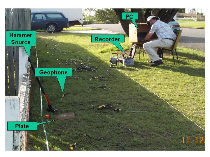
13 Seismic Acquisition 13

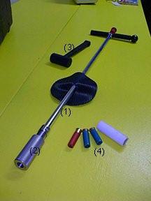
14 Seismic Source: Gun 14

15 Seismic Source: Hammer 15


16 Seismic Receiver: Geophone 16

17 Data Recording: Seismograph 17
18 db Background Noise 0 vertical-component local time [h] 18
19 Seismic Interpretation Three techniques: Refraction seismic: based on the direct and refracted waves Reflection seismic: based on the reflected waves Seismic refraction tomography : based on the direct and refracted waves 19
=1 and sin( i ) 1 V V 1 2 In this case, i 1 is called the critical angle i c")
20 Waves Propagation: Snell Law Analogy with optics: the Snell law sin( i ) sin( i ) 1 2 V V 1 2 when i 2 =90, then sin (i 2 )=1 and sin( i ) 1 V V 1 2 In this case, i 1 is called the critical angle i c 20
21 21
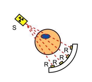


22 Seismic Tomography 22
![T-Dist/2000 [ms] Shot S1 NW](/docs-images/81/83456397/images/23-1.jpg "0-50 0 50 100 m SE 100 150")
23 T-Dist/2000 [ms] Shot S1 NW m SE

24 Seismic tomography inversion 24
25 T-Dist/2000 [ms] Initial Traveltimes Distance [m] 25
![T-Dist/2000 [ms]](/docs-images/81/83456397/images/26-0.jpg "Final Traveltimes 50")

26 T-Dist/2000 [ms] Final Traveltimes Distance [m] 26
![Depth [m] T-Dist/2 0 [ms] Final Traveltimes 50 40 30 20 10 0 0 50 100 150 200 250](/docs-images/81/83456397/images/27-0.jpg "Distance [m] Raypaths q2 NW 20 25 l1 l2 l3 SE 30 35 40 45 50 0 50 100 150 200 Distance")
27 Depth [m] T-Dist/2 0 [ms] Final Traveltimes Distance [m] Raypaths q2 NW l1 l2 l3 SE Distance [m] 27


28 Refraction Seismic 28
29 Refraction Seismic 29
30 Refraction Seismic 30
31 Interpretation of Refraction Data Solution for two horizontal layers. The unknown parameters are the depth h and the velocities of the two layers. V 1 is given by the slope of the direct arrival segment V 2 is given by the slope of the refracted arrival segment h using the crossover distance: h using the intercept time: h h X b V V 2 V V Ti V V V 1 2 V
32 Reflection Seismic 32

33 Reflection Seismic Acquisition Concept of Common Midle Point (CMP) 33
34 Reflection seismic processing 34

35 Migration and result: the seismic section 35
36 Some Examples Some examples of refraction, reflection and tomography seismic for archeological applications 36

37 MappingtheAncient Port at the Archaeological Siteof Itanos (Greece) Using Shallow Seismic Methods Vafidis et al., 2007, Archeological Prospection, 10, shots 37

38 MappingtheAncient Port at the Archaeological Siteof Itanos (Greece) Using Shallow Seismic Methods Refraction profile Vafidis et al., 2007, Archeological Prospection, 10,

39 Mapping the Ancient Port at the Archaeological Site of Itanos (Greece) Using Shallow Seismic Methods Vafidis et al., 2007, Archeological Prospection, 10,

40 Exploration of the Canal of Xerxes, Northern Greece Reflection profile Refraction profile Jones et al., 2000, Archeological Prospection, 70,

41 Investigation of a Monumental Macedonian Tumulus by Three dimensional Seismic Tomography Polymenakos et al., 2004, Archeological Prospection, 11,

42 Combined Seismic Tomographic and Ultrashallow Seismic Reflection Study of an Early Dynastic Mastaba, Saqqara, Egypt Metwaly et al., 2005, Archeological Prospection, 12,

43 Refraction Metwaly et al., 2005, Archeological Prospection, 12,
 Comparison with refraction Metwaly et al.")
44 Reflection profile in time Reflection profile in depth Reflection profile (migration for the first part) Comparison with refraction Metwaly et al., 2005, 44 Archeological Prospection, 12,
45 3. Conclusions for archaeology 45
46 Advantages Seismic used mainly to explore the geology related to archeological features (canal, port, bedrock) For results in the first meters, very high resolution seismic is used (distance between the geophones from a few cm to a few meters) Useful complement to resistivity 46
47 Drawbacks Sensitive to noise in urban areas Reflection seismic needs important processing steps The velocity must increase with depth for refraction! Velocity contrast must exist (void, slab, wall, soil) 47
Electrical Surveying (part A)
") Electrical Surveying (part A) Dr. Laurent Marescot Course given at the University of Fribourg (2009) Contact: laurent@tomoquest.com www.tomoquest.com 1 Introduction Electrical surveying Resistivity method
Electrical Surveying (part A) Dr. Laurent Marescot Course given at the University of Fribourg (2009) Contact: laurent@tomoquest.com www.tomoquest.com 1 Introduction Electrical surveying Resistivity method
Geophysical Site Investigation (Seismic methods) Amit Prashant Indian Institute of Technology Gandhinagar
 Amit Prashant Indian Institute of Technology Gandhinagar") Geophysical Site Investigation (Seismic methods) Amit Prashant Indian Institute of Technology Gandhinagar Short Course on Geotechnical Aspects of Earthquake Engineering 04 08 March, 2013 Seismic Waves
Geophysical Site Investigation (Seismic methods) Amit Prashant Indian Institute of Technology Gandhinagar Short Course on Geotechnical Aspects of Earthquake Engineering 04 08 March, 2013 Seismic Waves
1. Resistivity of rocks
 RESISTIVITY 1) Resistivity of rocks 2) General principles of resistivity surveying 3) Field procedures, interpretation and examples 4) Summary and conclusions INDUCED POLARIZATION 1) General principles
LECTURE 10. Module 3 : Field Tests in Rock 3.6 GEOPHYSICAL INVESTIGATION
 LECTURE 10 3.6 GEOPHYSICAL INVESTIGATION In geophysical methods of site investigation, the application of the principles of physics are used to the study of the ground. The soil/rock have different characteristics
SEISMIC SURVEY METHODS
 SEISMIC SURVEY METHODS Seismic methods Seismic surveys are used in geology and geotechnical engineering to: a) define the depth of the bedrock; b) investigate the landslide areas, c) check the structural
Geophysics for Environmental and Geotechnical Applications
 Geophysics for Environmental and Geotechnical Applications Dr. Katherine Grote University of Wisconsin Eau Claire Why Use Geophysics? Improve the quality of site characterization (higher resolution and
ERTH2020 Introduction to Geophysics The Seismic Method. 1. Basic Concepts in Seismology. 1.1 Seismic Wave Types
 ERTH2020 Introduction to Geophysics The Seismic Method 1. Basic Concepts in Seismology 1.1 Seismic Wave Types Existence of different wave types The existence of different seismic wave types can be understood
SEISMIC REFRACTION ANALYSIS OF EAST RIVER FLATS MINNEAPOLIS MINNESOTA A THESIS SUBMITTED TO THE FACULTY OF UNIVERSITY OF MINNESOTA AUTUMN HAAGSMA
 SEISMIC REFRACTION ANALYSIS OF EAST RIVER FLATS MINNEAPOLIS MINNESOTA A THESIS SUBMITTED TO THE FACULTY OF UNIVERSITY OF MINNESOTA BY AUTUMN HAAGSMA IN PARTIAL FULFILLMENT OF THE REQUIREMENTS FOR THE DEGREE
High Resolution Geophysics: A Better View of the Subsurface. By John Jansen, P.G., Ph.D., Aquifer Science and Technology
 High Resolution Geophysics: A Better View of the Subsurface By John Jansen, P.G., Ph.D., Aquifer Science and Technology Geologist Use Only Part of the Information Available To Them Most Geologist rely
Downhole Seismic Velocity Logging Test
 Objective Downhole Seismic Velocity Logging Test In this experiment, Velocity Logging Test (Downhole method) is done to find the physical properties of the soil ground from site investigation. Velocity
Acquisition and preliminary analysis of the Castle Mountain shallow VSP dataset
 Castle Mountain shallow VSP Acquisition and preliminary analysis of the Castle Mountain shallow VSP dataset Joe Wong, Henry C. Bland, Kevin W. Hall and Robert R. Stewart ABSTRACT As part of the 2006 geophysics
Static Corrections for Seismic Reflection Surveys
 Static Corrections for Seismic Reflection Surveys MIKE COX Volume Editors: Series Editor: Eugene F. Scherrer Roland Chen Eugene F. Scherrer Society of Exploration Geophysicists Tulsa, Oklahoma Contents
Basic principles of the seismic method
 Chapter 2 Basic principles of the seismic method In this chapter we introduce the basic notion of seismic waves. In the earth, seismic waves can propagate as longitudinal (P) or as shear (S) waves. For
Seismologia A Seismology A Lecture 9: Engineering seismology: seismic veloci:es in soils
 Seismologia 494304A Seismology 494304A 20.03.2018 Lecture 9: Engineering seismology: seismic veloci:es in soils h
Groundwater Sustainability at Wadi Al Bih Dam, Ras El Khaimah, United Arab Emirates (UAE) using Geophysical methods
 using Geophysical methods") Groundwater Sustainability at Wadi Al Bih Dam, Ras El Khaimah, United Arab Emirates (UAE) using Geophysical methods Ahmed Murad, Amir Gabr, Saber Mahmoud, Hasan Arman & Abdulla Al Dhuhoori Geology Department
Groundwater Sustainability at Wadi Al Bih Dam, Ras El Khaimah, United Arab Emirates (UAE) using Geophysical methods Ahmed Murad, Amir Gabr, Saber Mahmoud, Hasan Arman & Abdulla Al Dhuhoori Geology Department
ERTH2020 Tutorial Exercise 1: Basic Maths Revision - Answers
 ERTH2020 Tutorial 1 Maths Revision Page 1 ERTH2020 Tutorial Exercise 1: Basic Maths Revision - Answers The purpose of this document is to provide answers - not working. Note that in an exam situation you
Seismoelectric Ground-flow DC-4500 Locator
 Seismoelectric Ground-flow DC-4500 Locator Introduction The seismoelectric survey is a new technology combined the electro kinetic potential method and geophysical technology. It is applied directly to
Hydrogeophysics - Seismics
 Hydrogeophysics - Seismics Matthias Zillmer EOST-ULP p. 1 Table of contents SH polarized shear waves: Seismic source Case study: porosity of an aquifer Seismic velocities for porous media: The Frenkel-Biot-Gassmann
Determination of Incompressibility, Elasticity and the Rigidity of Surface Soils and Shallow Sediments from Seismic Wave Velocities
 Journal of Earth Sciences and Geotechnical Engineering, vol. 6, no.1, 2016, 99-111 ISSN: 1792-9040 (print), 1792-9660 (online) Scienpress Ltd, 2016 Determination of Incompressibility, Elasticity and the
Hybrid Seismic Survey on the Gamanjunni Rockslide Site
 Hybrid Seismic Survey on the Gamanjunni Rockslide Site by Walter Frei; info@geoexpert.ch NVE Workshop / Oslo 30.-31. January 2017 (1) Pictorial Introduction to Hybrid Seismic Profiling (2) Recommended
Patterns in Geophysical Data and Models
 Patterns in Geophysical Data and Models Jens Tronicke Angewandte Geophysik Institut für Geowissenschaften Universität Potsdam jens@geo.uni-potsdam.de Near-surface geophysics Using geophysical tools to
Near-Surface Seismic Reflection Applications
 Near-Surface Seismic Reflection Applications Don Steeples, The University of Kansas, Lawrence, KS USA Abstract Nonintrusive methods of gaining knowledge about the Earth s subsurface comprise several of
The Application of Shallow Seismic Refraction Method to Study the Dynamics Properties of Soil in Atbara Area, Sudan
 International Journal of Service Science, Management and Engineering 2018; 5(3): 117-124 http://www.openscienceonline.com/journal/ssme ISSN: 2381-6031 (Print); ISSN: 2381-604X (Online) The Application
Geological Mapping using Geophysics
 Geological Mapping using Geophysics Pugin, A.J.M. and T.H. Larson Illinois State Geological Survey, 615 E Peabody Dr., Champaign, IL 61820; E-mail: A.J.M. Pugin at pugin@isgs.uiuc.edu Mapping Techniques.
MOUNT POLLEY MINING CORPORATION TECHNICAL REPORT ON MULTI-ELECTRODE RESISTIVITY AND SEISMIC REFRACTION SURVEYS MOUNT POLLEY TAILINGS DAM PROJECT
 MOUNT PLEY MINING CORPORATION TECHNICAL REPORT ON MULTI-ELECTRODE RESISTIVITY AND SEISMIC REFRACTION SURVEYS MOUNT PLEY TAILINGS DAM PROJECT LIKELY, B.C. by Claudia Krumbiegel, M.Sc. Cliff Candy, P.Geo.
Groundwater Level Monitoring of the Quaternary Aquifer at Al Ain City, United Arab Emirates (UAE) using Geophysical Methods
 using Geophysical Methods") Groundwater Level Monitoring of the Quaternary Aquifer at Al Ain City, United Arab Emirates (UAE) using Geophysical Methods Ahmed Murad & Amir Gabr Geology Department UAE University Outlines Introduction
Groundwater Level Monitoring of the Quaternary Aquifer at Al Ain City, United Arab Emirates (UAE) using Geophysical Methods Ahmed Murad & Amir Gabr Geology Department UAE University Outlines Introduction
International Journal of Scientific & Engineering Research, Volume 6, Issue 12, December ISSN
 International Journal of Scientific & Engineering Research, Volume 6, Issue 12, December-2015 1052 Determination of Lame s Constants of Surface soils and Shallow Sediments from Seismic Wave Velocities
Imaging complex structure with crosswell seismic in Jianghan oil field
 INTERPRETER S CORNER Coordinated by Rebecca B. Latimer Imaging complex structure with crosswell seismic in Jianghan oil field QICHENG DONG and BRUCE MARION, Z-Seis, Houston, Texas, U.S. JEFF MEYER, Fusion
Appendix J. Geological Investigation
 Appendix J Geological Investigation Appendix J Geological Environment Table of Contents Page 1 INTRODUCTION...J-1 1.1 Purpose of the Investigation...J-1 1.2 Scope of the Investigation...J-1 2 METHODO OF
Department of Geophysics Faculty of Earth Sciences King Abdulaziz University
 Department of Geophysics Faculty of Earth Sciences King Abdulaziz University Dr. Mansour A. Al-Garni Office: room 233/Buld. 27 OR Dept. chair office/buld. 55 Introduction to Geophysics EGP 211 Time: 10-10:55
Seismic Velocity Measurements at Expanded Seismic Network Sites
 UK/KRCEE Doc #: P8.3 2005 Seismic Velocity Measurements at Expanded Seismic Network Sites Prepared by Kentucky Research Consortium for Energy and Environment 233 Mining and Minerals Building University
INTRODUCTION TO APPLIED GEOPHYSICS
 INTRODUCTION TO APPLIED GEOPHYSICS EXPLORING THE SHALL0W SUBSURFACE H. Robert Burger Anne F. Sheehan Craig H.Jones VERSITY OF COLORADO VERSITY OF COLORADO W. W. NORTON & COMPANY NEW YORK LONDON Contents
Lima Project: Seismic Refraction and Resistivity Survey. Alten du Plessis Global Geophysical
 Lima Project: Seismic Refraction and Resistivity Survey Alten du Plessis Global Geophysical Report no 0706/2006 18 December 2006 Lima Project: Seismic Refraction and Resistivity Survey by Alten du Plessis
Refraction seismic Method
 Refraction seismic Method Field techniques Inversion for refractor velocity, depth, and dip Delay time Interpretation Basic-formula methods Delay-time methods Wavefront reconstruction methods Reading:
Integration of Seismic Refraction and 2D Electrical Resistivity in Locating Geological Contact
 Open Journal of Geology, 2013, 3, 7-12 doi:10.4236/ojg.2013.32b002 Published Online April 2013 (http://www.scirp.org/journal/ojg) Integration of Seismic Refraction and 2D Electrical Resistivity in Locating
ANGLE-DEPENDENT TOMOSTATICS. Abstract
 ANGLE-DEPENDENT TOMOSTATICS Lindsay M. Mayer, Kansas Geological Survey, University of Kansas, Lawrence, KS Richard D. Miller, Kansas Geological Survey, University of Kansas, Lawrence, KS Julian Ivanov,
GEOPHYSICAL SITE CHARACTERIZATION IN SUPPORT OF HIGHWAY EXPANSION PROJECT
 GEOPHYSICAL SITE CHARACTERIZATION IN SUPPORT OF HIGHWAY EXPANSION PROJECT * Shane Hickman, * Todd Lippincott, * Steve Cardimona, * Neil Anderson, and + Tim Newton * The University of Missouri-Rolla Department
PART A: Short-answer questions (50%; each worth 2%)
") PART A: Short-answer questions (50%; each worth 2%) Your answers should be brief (just a few words) and may be written on these pages if you wish. Remember to hand these pages in with your other exam pages!
PART A: Short-answer questions (50%; each worth 2%) Your answers should be brief (just a few words) and may be written on these pages if you wish. Remember to hand these pages in with your other exam pages!
Chapter 12 Subsurface Exploration
 Page 12 1 Chapter 12 Subsurface Exploration 1. The process of identifying the layers of deposits that underlie a proposed structure and their physical characteristics is generally referred to as (a) subsurface
Downloaded 07/03/14 to Redistribution subject to SEG license or copyright; see Terms of Use at
 Downloaded 07/03/14 to 129.237.143.21. Redistribution subject to SEG license or copyright; see Terms of Use at http://library.seg.org/ Rayleigh-wave diffractions due to a void in the layered half space
APPLICATION OF ELECTRICAL RESISTIVITY TOMOGRAPHY FOR SAND UNDERWATER EXTRACTION
 International Scientific Conference GEOBALCANICA 2018 APPLICATION OF ELECTRICAL RESISTIVITY TOMOGRAPHY FOR SAND UNDERWATER EXTRACTION Maya Grigorova Ivaylo Koprev University of Mining and Geology St. Ivan
Oil and Gas Research Institute Seismic Analysis Center Faults Detection Using High-Resolution Seismic Reflection Techniques
 Oil and Gas Research Institute Seismic Analysis Center Faults Detection Using High-Resolution Seismic Reflection Techniques Ghunaim T. Al-Anezi (KACST) March 2013 1 Objectives The objective of the survey
Geophysical Applications GPR Ground Penetrating Radar
 Overview: Basics of GPR Radar-wave velocity, attenuation and skin depth Modes of acquisition The Radar-range equation Dielectric properties of materials and relation to porosity Case studies [Archeology,
DOWN-HOLE SEISMIC SURVEY AND VERTICAL ELECTRIC SOUNDINGS RABASKA PROJECT, LÉVIS, QUÉBEC. Presented to :
 DOWN-HOLE SEISMIC SURVEY AND VERTICAL ELECTRIC SOUNDINGS RABASKA PROJECT, LÉVIS, QUÉBEC Presented to : TERRATECH 455, René-Lévesque Blvd. West Montreal, Québec HZ 1Z3 Presented by : GEOPHYSICS GPR INTERNATIONAL
Seismic applications in coalbed methane exploration and development
 Seismic applications in coalbed methane exploration and development Sarah E. Richardson*, Dr. Don C. Lawton and Dr. Gary F. Margrave Department of Geology and Geophysics and CREWES, University of Calgary
Seismic Refraction Survey for Groundwater Potentials of Northern Paiko Area. Niger State, Nigeria.
 IOSR Journal of Applied Geology and Geophysics (IOSR-JAGG) e-issn: 2321 0990, p-issn: 2321 0982.Volume 3, Issue 2 Ver. I (Mar - Apr. 2015), PP 41-48 www.iosrjournals.org Seismic Refraction Survey for Groundwater
Evaluation of Geological Conditions Ahead of Tunnel Face Using Seismic Tomography between Tunnel and Surface
 Evaluation of Geological Conditions Ahead of Tunnel Face Using Seismic Tomography between Tunnel and Surface Y. Yokota a *, T. Ymamoto a and K. Kurihara a a Kajima Technical Research Institute, 19-1, Tobitakyu
Geophysical Investigation of Ground Water Using Vertical Electrical Sounding and Seismic Refraction Methods
 International Journal of Petroleum and Petrochemical Engineering (IJPPE) Volume 2, Issue 1, 2016, PP 6-11 ISSN 2454-7980 (Online) www.arcjournals.org Geophysical Investigation of Ground Water Using Vertical
High Resolution Time-domain Induced Polarization Tomography with Merging Data Levels by Two Different Optimized Arrays for Slope Monitoring Study
 High Resolution Time-domain Induced Polarization Tomography with Merging Data Levels by Two Different Optimized Arrays for Slope Monitoring Study Andy A. Bery Geophysics Section, School of Physics, Universiti
Seismic tests at Southern Ute Nation coal fire site
 Seismic tests at Southern Ute Nation coal fire site Sjoerd de Ridder and Seth S. Haines ABSTRACT We conducted a near surface seismic test at the Southern Ute Nation coal fire site near Durango, CO. The
Seismic Reflection Imaging across the Johnson Ranch, Valley County, Idaho
 Seismic Reflection Imaging across the Johnson Ranch, Valley County, Idaho Report Prepared for the Skyline Corporation Lee M. Liberty Center for Geophysical Investigation of the Shallow Subsurface (CGISS)
Preliminary results for a near surface 3D seismic survey of a geothermal system in Colorado
 Preliminary results for a near surface 3D seismic survey of a geothermal system in Colorado Andrew Lamb 1, Kasper van Wijk 1, Lee Liberty 1, Mike Batzle 2, André Revil 2, Kyle Richards 2 and Chuck Diggins
STUDY OF ENGINEERING PROPERTIES BY USING DOWNHOLE METHOD FOR SOUTH BAGHDAD AREA IN IRAQ
 International Journal of Civil Engineering and Technology (IJCIET) olume 9, Issue 9, September 0, pp. 0 0, Article ID: IJCIET_09_09_0 Available online at http://www.iaeme.com/ijciet/issues.asp?jtype=ijciet&type=9&itype=9
Applying Seismic Refraction Method in Depicting Geological Contact at Bukit Bunuh, Lenggong, Perak, Malaysia
 2012 International Conference on Geological and Environmental Sciences IPCBEE vol.3 6(2012) (2012)IACSIT Press, Singapoore Applying Seismic Refraction Method in Depicting Geological Contact at Bukit Bunuh,
International Journal of Advanced and Applied Sciences
 International Journal of Advanced and Applied Sciences, 3(5) 2016, Pages: 65 72 Contents lists available at Science Gate International Journal of Advanced and Applied Sciences Journal homepage: http://www.science
Seismic Refraction Investigation at a Radioactive Waste Disposal Site
 Geosciences 2012, 2(2): 7-13 DOI: 10.5923/j.geo.20120202.02 Seismic Refraction Investigation at a Radioactive Waste Disposal Site A. M. A Dawood 1,*, T. T. Akiti 2, E. T. Glover 1 1 National Radioactive
CENTER FOR INFRASTRUCTURE ENGINEERING STUDIES
 1 CENTER FOR INFRASTRUCTURE ENGINEERING STUDIES Acquisition of an Engineering Seismograph By Dr. Neil Anderson UTC RE116 University Transportation Center Program at The University of Missouri-Rolla 2 Disclaimer
Geophysical mapping and imaging of soil structures: basic overview
 Geophysical mapping and imaging of soil structures: basic overview Stéphane Garambois Landslide team, LGIT, Université Joseph Fourier 3D imaging of the water table (seismic) Geophysical methods 1 Plan
This document downloaded from vulcanhammer.net vulcanhammer.info Chet Aero Marine
 This document downloaded from vulcanhammer.net vulcanhammer.info Chet Aero Marine Don t forget to visit our companion site http://www.vulcanhammer.org Use subject to the terms and conditions of the respective
Techniques for determining the structure and properties of permafrost
 Stanford Exploration Project, Report 80, May 15, 2001, pages 1 404 Techniques for determining the structure and properties of permafrost Ray Abma 1 ABSTRACT Several methods for predicting the relationship
Walkaway Seismic Experiments: Stewart Gulch, Boise, Idaho
 Walkaway Seismic Experiments: Stewart Gulch, Boise, Idaho Lee M. Liberty Center for Geophysical Investigation of the Shallow Subsurface Boise State University Boise, Idaho 1. Summary CGISS conducted walkaway
Earthquakes and Earth s Interior
 - What are Earthquakes? Earthquakes and Earth s Interior - The shaking or trembling caused by the sudden release of energy - Usually associated with faulting or breaking of rocks - Continuing adjustment
The 2D/3D i-stats Workflow for Image-Based Near-Surface Modeling for Statics Corrections
 The 2D/3D i-stats Workflow for Image-Based Near-Surface Modeling for Statics Corrections Öz Yilmaz CTO, GeoTomo LLC With the i-stats workflow, you no longer need first-break picking as for traveltime tomography,
PE OIL AND GAS EXPLORATION METHODS COURSE STRUCTURE. I. FUNDAMENTAL CONSIDERATIONS (5 Hrs.) III. SEISMIC REFLECTION METHOD
 III. SEISMIC REFLECTION METHOD") PE6050 - OIL AND GAS EXPLORATION METHODS Total Hours: 50 Faculty: Dr. Rajesh R Nair COURSE STRUCTURE I. FUNDAMENTAL CONSIDERATIONS (5 Hrs.) - Stress - Strain Relationship - Elastic Coefficients - Seismic
PE6050 - OIL AND GAS EXPLORATION METHODS Total Hours: 50 Faculty: Dr. Rajesh R Nair COURSE STRUCTURE I. FUNDAMENTAL CONSIDERATIONS (5 Hrs.) - Stress - Strain Relationship - Elastic Coefficients - Seismic
Basim R. Hijab, Amer Al-Khalidy University of Baghdad, Department of Earth Science
 INTEGRATED GEOPHYSICAL TESTS FOR THE GEOTECHNICAL CHARACTERIZATION OF THE SANDY FOUNDATION FOR PROPOSED METRO- TUNNEL AT THE NAJAF AREA, SOUTHERN IRAQ. Ammar M.Shakir, Flora Garofalo, Sebastiano Foti Politecnico
Site Characterization & Hydrogeophysics
 Site Characterization & Hydrogeophysics (Source: Matthew Becker, California State University) Site Characterization Definition: quantitative description of the hydraulic, geologic, and chemical properties
Section 19.1: Forces Within Earth Section 19.2: Seismic Waves and Earth s Interior Section 19.3: Measuring and Locating.
 CH Earthquakes Section 19.1: Forces Within Earth Section 19.2: Seismic Waves and Earth s Interior Section 19.3: Measuring and Locating Earthquakes Section 19.4: Earthquakes and Society Section 19.1 Forces
SEISMIC REFRACTION INVESTIGATION OF THE SUBSURFACE STRUCTURE AT THE SOUTHERN PART OF NIGER STATE COLLEGE OF EDUCATION, MINNA, NIGERIA
 Bayero Journal of Pure and Applied Sciences, 3(2): 56-6 Received: May, 200 Accepted: October, 200 ISSN 2006-6996 SEISMIC REFRACTION INVESTIGATION OF TE SUBSURFACE STRUCTURE AT TE SOUTERN PART OF NIGER
ambiguity in earth sciences IESO Geophysics Section Eddy hartantyo, Lab Geofisika FMIPA UGM
 ambiguity in earth sciences IESO Geophysics Section Eddy hartantyo, Lab Geofisika FMIPA UGM Pelatihan Tahap II IESO Teknik Geologi UGM Februari 2009 1 Introduction Photos from http://www.eegs.org/whatis/
P128 Subsurface Fault and Colluvial Wedge Detection Using Resistivity, Refraction Tomography and Seismic Reflection
 P128 Subsurface Fault and Colluvial Wedge Detection Using Resistivity, Refraction Tomography and Seismic Reflection S.M. Hanafy* (King Abdullah University of Science & Technology) SUMMARY Electric resistivity
Appendix B: Geophysical Data (Thesis Appendix, 2013)
") Utah State University From the SelectedWorks of David J Richey 2013 Appendix B: Geophysical Data (Thesis Appendix, 2013) David J Richey, Utah State University Available at: https://works.bepress.com/david_richey/2/
Utah State University From the SelectedWorks of David J Richey 2013 Appendix B: Geophysical Data (Thesis Appendix, 2013) David J Richey, Utah State University Available at: https://works.bepress.com/david_richey/2/
Section Forces Within Earth. 8 th Grade Earth & Space Science - Class Notes
 Section 19.1 - Forces Within Earth 8 th Grade Earth & Space Science - Class Notes Stress and Strain Stress - is the total force acting on crustal rocks per unit of area (cause) Strain deformation of materials
Downloaded 05/01/17 to Redistribution subject to SEG license or copyright; see Terms of Use at
 Mapping Imbricate Structures in the Thrust Belt of Southeast Turkey by Large-Offset Seismic Survey Oz Yilmaz*, Anatolian Geophysical, Istanbul, Turkey; and Serdar Uygun, Ali Ölmez, and Emel Çalı, Turkish
DEPTH AND VELOCITY ESTIMATES FROM SEISMIC WAVES REFRACTION PATHS AT EBONYI STATE UNIVERSITY STAFF SCHOOL, ABAKALIKI, NIGERIA ABSTRACT
 DEPTH AND VELOCITY ESTIMATES FROM SEISMIC WAVES REFRACTION PATHS AT EBONYI STATE UNIVERSITY STAFF SCHOOL, ABAKALIKI, NIGERIA Agha, S. O. Dept. of Industrial Physics Ebonyi State University Abakaliki, NIGERIA
Last Time. Today s s Agenda. Geophysics. Geophysics. Geophysics. MAS 603: Geological Oceanography. Lecture 21: Geophysics 1: Gravity
 UNIVERSITY OF SOUTH ALABAMA Last Time MAS 603: Geological Oceanography Extinctions Lecture 21: 1: http://www.cartoonstock.com/newscartoons/cartoonists/for/lowres/forn441l.jpg Today s s Agenda Introduction
GRAVITY EXPLORATION. subsurface density. (material property) Gravity anomalies of some simple shapes
 Gravity anomalies of some simple shapes") GRAVITY EXPLORATION g at surface (observation) subsurface density (material property) subsurface geology Gravity anomalies of some simple shapes Reminder: we are working with values about... 0.01-0.001
GRAVITY EXPLORATION g at surface (observation) subsurface density (material property) subsurface geology Gravity anomalies of some simple shapes Reminder: we are working with values about... 0.01-0.001
Surface and borehole electrical resistivity tomography
 Surface and borehole electrical resistivity tomography Laurent Marescot laurent@tomoquest.com Introduction Surface electrical resistivity surveying is based on the principle that the distribution of electrical
M035 High Resolution 3D Tunnel Seismic Reflection at Olkiluoto, Finland
 M035 High Resolution 3D Tunnel Seismic Reflection at Olkiluoto, Finland C. Cosma* (Vibrometric), N. Enescu (Vibrometric), M. Lahti (Posiva Oy), E. Heikkinen (Poyry Oy) & T. Ahokas (Poyry Oy) SUMMARY ONKALO
SEISMIC INVESTIGATION OF UNDERGROUND COAL FIRES; A FEASIBILITY STUDY AT THE SOUTHERN UTE NATION COAL FIRE SITE, DURANGO, COLORADO.
 SEISMIC INVESTIGATION OF UNDERGROUND COAL FIRES; A FEASIBILITY STUDY AT THE SOUTHERN UTE NATION COAL FIRE SITE, DURANGO, COLORADO Sjoerd de Ridder, Department of Geophysics, Stanford University. Nigel
Tu 22P1 04 Combination of Geophysical Technques to Characterize Sediments (Ebro Delta, Spain)
") Tu 22P1 04 Combination of Geophysical Technques to Characterize Sediments (Ebro Delta, Spain) B. Benjumea* (Institut Cartografic i Geologic de Catalunya (ICGC)), A. Gabàs (ICGC), A. Macau (ICGC), F. Bellmunt
Tu 22P1 04 Combination of Geophysical Technques to Characterize Sediments (Ebro Delta, Spain) B. Benjumea* (Institut Cartografic i Geologic de Catalunya (ICGC)), A. Gabàs (ICGC), A. Macau (ICGC), F. Bellmunt
CONTENTS 1. INTRODUCTION. 2. THE D.C. RESISTIVITY METHOD 2.1 Equipment 2.2 Survey Procedure 2.3 Data Reduction
 (i) CONTENTS 1. INTRODUCTION page 1 2. THE D.C. RESISTIVITY METHOD 2.1 Equipment 2.2 Survey Procedure 2.3 Data Reduction 3 3 3 3 3. GEOPHYSICAL RESULTS 3.1 General 3.2 Discussion 4 4 4 4. LIMITATIONS 5
Repeatability in geophysical data processing: A case study of seismic refraction tomography.
 Available online at www.scholarsresearchlibrary.com Archives of Applied Science Research, 2012, 4 (5):1915-1922 (http://scholarsresearchlibrary.com/archive.html) ISSN 0975-508X CODEN (USA) AASRC9 Repeatability
GPR profiling and electrical resistivity tomography for buried cavity detection: a test site at the Abbaye de l'ouye (France)
") GPR profiling and electrical resistivity tomography for buried cavity detection: a test site at the Abbaye de l'ouye (France) Nerouz BOUBAKI, Albane SAINTENOY, Piotr TUCHOLKA IDES - UMR 8148 CNRS, Université
GPR profiling and electrical resistivity tomography for buried cavity detection: a test site at the Abbaye de l'ouye (France) Nerouz BOUBAKI, Albane SAINTENOY, Piotr TUCHOLKA IDES - UMR 8148 CNRS, Université
Y. Shioi 1, Y. Hashizume 2 and H. Fukada 3
 Y. Shioi 1, Y. Hashizume 2 and H. Fukada 3 1 Emeritus Professor, Hachinohe Institute of Technology, Hachinohe, Japan 2 Chief Engineer, Izumo, Misawa, Aomori, Japan 3 Profesr, Geo-Technical Division, Fudo
Compressional and Shear-Wave Velocity Measurements in Unconsolidated Top- Soil in Eket, South-eastern Nigeria.
 Compressional and Shear-Wave Velocity Measurements in Unconsolidated Top- Soil in Eket, South-eastern Nigeria. U.E. Essien, M.Sc. 1 and A.O. Akankpo, M.Sc. 2* 1 Department of Science and Technology, Akwa
Near-surface velocity characterization via RVSP and multicomponent seismic refraction experiments
 Near-surface multicomponent RVSP and refraction survey Near-surface velocity characterization via RVSP and multicomponent seismic refraction experiments Darryl G. Party and Don C. Lawton Abstract A shallow
Relationship between head wave amplitudes and seismic refraction velocities to detect lateral variation in the refractor
 Journal of the Earth and Space Physics, Vol. 41, No. 4, 016, PP. 69-76 Relationship between head wave amplitudes and seismic refraction velocities to detect lateral variation in the refractor Abstract
Improved Exploration, Appraisal and Production Monitoring with Multi-Transient EM Solutions
 Improved Exploration, Appraisal and Production Monitoring with Multi-Transient EM Solutions Folke Engelmark* PGS Multi-Transient EM, Asia-Pacific, Singapore folke.engelmark@pgs.com Summary Successful as
Time-lapse seismic modelling for Pikes Peak field
 Time-lapse seismic modelling for Pikes Peak field Ying Zou*, Laurence R. Bentley and Laurence R. Lines University of Calgary, 2500 University Dr, NW, Calgary, AB, T2N 1N4 zou@geo.ucalgary.ca ABSTRACT Predicting
A Study of Uphole to Determine the Shooting Medium for Seismic Reflection Survey at Himalayan Foot Hill Area
 A Study of Uphole to Determine the Shooting Medium for Seismic Reflection Survey at Himalayan Foot Hill Area Summary Binode Chetia Frontier Basins, ONGC, Dehradun E-mail: chetia_binode@ongc.co.in Acquiring
3D land seismic with low environmental impact: a case study from the Murchison Falls National Park, Uganda
 P1-2-12 3D land seismic with low environmental impact: a case study from the Murchison Falls National Park, Uganda Keith Mills 1, Abderrahim Lafram 2, Michael Igoe 3, Sharon Cooper 1, Louise Moorhead 1,
Reinforced Soil Structures Reinforced Soil Walls. Prof K. Rajagopal Department of Civil Engineering IIT Madras, Chennai
 Geosynthetics and Reinforced Soil Structures Reinforced Soil Walls continued Prof K. Rajagopal Department of Civil Engineering IIT Madras, Chennai e-mail: gopalkr@iitm.ac.inac in Outline of the Lecture
Downloaded 06/30/14 to Redistribution subject to SEG license or copyright; see Terms of Use at
 Evaluation of extended correlation on shallow Vibroseis data Bevin L. Bailey*, Don Steeples, The University of Kansas, Richard D. Miller, Shelby Peterie, and Julian Ivanov, Kansas Geological Survey, Richard
EOS 350 MIDTERM OCT 4, 2013 STUDENT NAME: TEAM #:
 EOS 350 MIDTERM OCT 4, 2013 STUDENT NAME: TEAM #: Some equations which may, or may not, be useful: Distance from sensor to a dipole z ~ x ½, Distance to line of dipoles z ~ 0.75x ½ B = μh, M = κh Seismic
Oil & Gas. From exploration to distribution. Week 1 V05 Origin of hydrocarbon resources part 1. Jean-Pierre Deflandre
 Oil & Gas From exploration to distribution Week 1 V05 Origin of hydrocarbon resources part 1 Jean-Pierre Deflandre W1V5 Origin of hydrocarbon resources1 p. 1 Introduction to hydrocarbon resources You will
Common Exploration Methods.
 Common Exploration Methods. The following list contains the most common methods which a company with a mineral prospecting licence in Northern Ireland might use to carry out a mineral prospecting programme.
Crosswell tomography imaging of the permeability structure within a sandstone oil field.
 Crosswell tomography imaging of the permeability structure within a sandstone oil field. Tokuo Yamamoto (1), and Junichi Sakakibara (2) (1) University of Miami and Yamamoto Engineering Corporation, (2)
Electrical imaging techniques for hydrological and risk assessment studies
 Séminaire IPG le 9 mars 2006 Strasbourg Institute of Geophysics ETH Hoenggerberg CH-8093 Zurich Electrical imaging techniques for hydrological and risk assessment studies Laurent Marescot laurent@aug.ig.erdw.ethz.ch
A Comparison of Four Geophysical Methods for Determining the Shear Wave Velocity of Soils
 A Comparison of Four Geophysical Methods for Determining the Shear Wave Velocity of Soils Neil Anderson 1, Thanop Thitimakorn 1, David Hoffman 2, Richard Stephenson 2, Ronaldo Luna 2 Geological Sciences