Seismic Velocity Measurements at Expanded Seismic Network Sites
|
|
|
- Mercy Richardson
- 6 years ago
- Views:
Transcription

1 UK/KRCEE Doc #: P Seismic Velocity Measurements at Expanded Seismic Network Sites Prepared by Kentucky Research Consortium for Energy and Environment 233 Mining and Minerals Building University of Kentucky, Lexington, KY Prepared for United States Department of Energy Portsmouth/Paducah Project Office Acknowledgment: This material is based upon work supported by the Department of Energy under Award Number DE-FG05-03OR January 2005
2 UK/KRCEE Doc #: P Seismic Velocity Measurements at Expanded Seismic Network Sites Prepared by Principal Investigator: Edward W. Woolery Department of Earth and Environmental Sciences University of Kentucky 101 Slone Research Building Lexington, KY Co-Investigator: Zhenming Wang Kentucky Geological Survey 228 Mining and Mineral Resources Building Lexington, KY The views and conclusions contained in this document are those of the authors and should not be interpreted as necessarily representing the official policies, either expressed or implied of the Commonwealth of Kentucky. January 2005
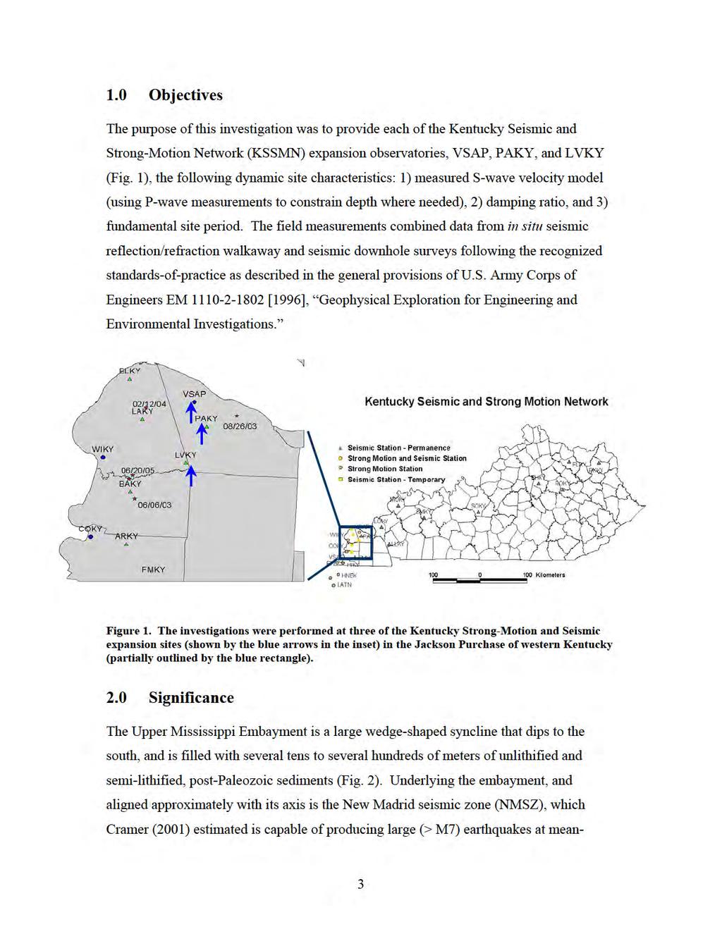
3 Executive Summary Structures at the Paducah Gaseous Diffusion Plant (PGDP), as well as at other locations in the northern Jackson Purchase of western Kentucky may be subjected to large far-field earthquake ground motions from the New Madrid seismic zone, as well as those from small and moderate-sized local events. The resultant ground motion a particular structure is exposed from such events will be a consequence of the earthquake magnitude, the structure s proximity to the event, and the dynamic and geometrical characteristics of the thick soils upon which they are, of necessity, constructed. This investigation evaluated the latter. Downhole and surface (i.e., refraction and reflection) seismic velocity data were collected at the Kentucky Seismic and Strong-Motion Network expansion sites in the vicinity of the Paducah Gaseous Diffusion Plant (PGDP) to define the dynamic properties of the deep sediment overburden that can produce modifying effects on earthquake waves. These effects are manifested as modifications of the earthquake waves amplitude, frequency, and duration. Each of these three ground motion manifestations is also fundamental to the assessment of secondary earthquake engineering hazards such as liquefaction. The expected earthquake ground motions are routinely modeled using one-dimensional linear-equivalent response analyses. The numerical calculation of this soil transfer function on the propagating earthquake wave requires knowledge of the shear-wave velocities, damping ratios, and soil horizon thicknesses. The resultant dynamic properties from this investigation can be immediately used to model scenario design ground motions at the vertical strong motion array. Moreover, magnitude-distance equivalent comparisons of modeled ground motions with measured ground motions at the Paducah vertical strong-motion array (VSAP) can be used to determine and constrain any 2- or 3-dimensional effects not considered in the standard practice one-dimensional modeling techniques. 2
4
5
6 3.0 Field Methods The geophysical survey sites were located at the KSSMN expansion sites described by the coordinates listed below: VSAP: N/88.813W PAKY: N/88.772W LVKY: N/88.829W Surface refraction surveys at PAKY and LVKY were collected approximately 0.5km from the borehole coordinate because of cultural/natural obstructions. 3.1 Seismic Downhole The downhole shear-wave measurements were conducted by placing an S-wave energy source on the ground surface 2 meters from the borehole opening with a triaxial geophone array placed at various elevations in the borehole (Fig. 3). Figure 3. A schematic of a typical field setup used for a downhole seismic test (from Reynolds, 1997). 5
7
8 first-break travel-time picks were interactively selected using commercial signal processing software, VISTA 7.0 (Seismic Image Software Ltd., 1995) and the shear-wave velocity profile was subsequently calculated using generic spreadsheet algorithms. Figure 5. Uncorrected polarity tests were performed on the longitudinal (left) and transverse (right) elements of the downhole geophone in order to insure correct identification of the shear wave. In addition to the traditional downhole test described above, a walkaway vertical seismic profile (VSP) was performed in order to measure the bedrock shear-wave velocity. The energy source, borehole geophone, and processing procedures were identical to the simple downhole test. The difference between the surveys was defined by the geometrical acquisition configuration. The walkaway VSP placed the geophone at the bottom of the borehole (i.e., resting directly on the top of bedrock). Shear-wave energy was placed into the ground at increasing distances from the wellhead in order to develop and record a critically refracted wave along the top of rock. The initial sourcewellhead offset was 200 meters. The seismic energy source was stepped out at 10- meter increments to a maximum 580-meter source-wellhead offset. 3.2 Seismic Refraction The seismic refraction survey is a seismic drilling technique that samples a specific site by a variety of energy-source to receiver offsets (Fig. 5). The data set defines the twoway travel to the various subsurface refracting (and reflecting) impedance horizons. The 7
, 30-Hz, horizontally polarized geophones spaced at 3.05 m intervals.")
9 measured travel time and the known array geometry permit the seismic velocity and depth of each subsurface unit to be calculated. The two refraction arrays were collected using twenty-four (24), 30-Hz, horizontally polarized geophones spaced at 3.05 m intervals. The tests were reversed (to correct for non-horizontal horizons), with multiple reciprocity shot points for each line. The seismic energy was generated by 15 horizontal impacts of the 1-kg hammer to a modified H-pile section with a hold-down weight of 75 kg. To ensure the accurate identification of SH-mode events, impacts were recorded on each side of the energy source. By striking each side of the source and reversing the acquisition polarity of the engineering seismograph, inadvertent P- and SV-mode energy will stack in a destructive manner, while SH-mode will stack constructively. Refraction/reflection field records were also processed using commercial signal processing and interpretation software. A band-pass filter and an automatic gain control were applied to the records. No additional processing was necessary. Figure 5. A generalized schematic is shown on the left for the seismic refraction procedure with a simple one layer over infinite half space (from Lankston, 1990). The seismograms on the right are typical multi-layered reversed datasets that exhibit both refraction and reflection events. 4.0 Velocity Results 4.1. VSAP: The interval shear-wave velocities from the surface to a depth of 100 m ranged between 237 m/s and 618 m/s. These velocities were derived from fair-to-good quality data. The downhole waveform composite and the interpreted model are shown in Figure 6. The 8

10 detailed downhole measurements for the sites are given in the composite layer interpretations in Table 1. The results of the walkaway VSP are shown in figure 7. Two velocities, 595 m/s and 1630 m/s, were derived from the poor-to-fair quality dataset. These interpreted velocities correlate to the McNairy Formation and bedrock, respectively. The 595 m/s shear-wave velocity for the McNairy Formation is also similar to the interval velocities derived from the downhole survey. A rubber-banding technique available in VISTA70 allowed first-arrival time interpolation through areas of poor data quality. No signal was observed (or interpolated) beyond 490 meters, however. 100 m 0 time (ms) Figure 6a. The downhole s-wave waveform composite. 9
11 0 Shear-Wave Velocity Downhole Survey VSAP - Paducah Gaseous Diffusion Plant Velocity Curves Raw Picks 2 pt Smoothing Filter Depth Below Ground Surface (m) Shear-Wave Velocity (m/s) Figure 6b. The resultant raw and smoothed s-wave interval velocity plot. 10

 Figure 7. Best-fit curves through the composite seismic waveform data are shown.")
12 200 m 580 m 200 m 580 m time (ms) time (ms) Figure 7a. The composite seismic waveform data are shown for the walkaway VSP survey. The raw and filtered/gained data are shown on the right and left, respectively. 760 Shear-Wave Velocity Walkaway VSP VSAP - Paducah Gaseous Diffusion Plant Best-Fit X-T Curves McNairy Bedrock 1630 m/s First-Arrival Time (ms) m/s Horizontal Distance from Wellhead (m) Figure 7. Best-fit curves through the composite seismic waveform data are shown. A rubberbanding technique available in VISTA70 allowed first-arrival time interpolation through areas of poor data quality. No signal was seen (or interpolated) beyond 490 meters. 11
 125.")
13 4.2. PAKY: The shear-wave velocities from the surface to top-of-bedrock at a depth of 161 m ranged between 207 m/s and 448 m/s. These velocities were derived from fair-to-good quality data. The waveform composite and the interpreted model are shown in Figure 8. The composite layer interpretations are also shown in Table 1. 0 time (ms) m 0 Shear-Wave Velocity Refraction-Reflection Survey PAKY: Paducah, KY m Depth Below Ground Surface (m) Velocity (m/s) Figure 8. Surface refraction/reflection s-wave survey was performed near PAKY. An example of a composite seismic waveform field file is shown at the top, and the interpreted velocity model is shown at the bottom. 12
 125.")
14 4.3. LVKY: The shear-wave velocities from the surface to top-of-bedrock at a depth of 125 m ranged between 182 m/s and 618 m/s. These velocities were derived from fair-to-good quality data. The waveform composite and the interpreted model are shown in Figure 9. The composite layer interpretations are also shown in Table 1. 0 time (ms) m m 0 Shear-Wave Velocity Refraction-Reflection Survey LVKY: Lovelaceville, KY Depth Below Ground Surface (m) Velocity (m/s) Figure 9. Surface refraction/reflection s-wave survey was performed near LVKY. An example of a composite seismic waveform field file is shown at the top, and the interpreted velocity model is shown at the bottom. 13
15 4.0 Damping (δ) and Quality Factors (Q) Damping (δ) for the soil layers was estimated from the shear-wave velocities using the shear-wave quality factor (Q S ) and the relationship: δ ( 2Q ) 1 = S which is frequently used for small strains (i.e., 10-5 %) when the stress-strain behavior of the soil is approximately linear (Mok et al., 1988). Wang et al. (1994) used a pulsebroadening technique to find that the Q S of the unlithified soils in the northern Mississippi embayment, including the Jackson Purchase of western Kentucky, could be related to the shear-wave velocity of the soils by the relationship: Q 0.08V ± S = S Small strains for the northern Jackson Purchase area were specified in the analysis because any large earthquake is assumed to be in the far-field of the southern or central NMSZ. It is also unlikely that moderate-sized local events will induce nonlinear conditions. The resultant estimates for the damping factors are given in Table Dynamic Site Periods The n th natural frequency of a sediment deposit can be defined as a function of its shearwave velocity (V s ) and thickness (H): ω n V S π + nπ H 2 where, n = 0, 1, 2, 3,. Intrinsic damping of the medium will result in the decrease of the spectral ratio with increasing natural frequency, however. Consequently, the highest spectral ratio will occur approximately at the lowest natural frequency (i.e., first harmonic). Therefore, the fundamental natural frequency can be written as: V S π ω 0 =. 2H The period (T) that corresponds to the fundamental natural frequency is called the dynamic site period: T 2π = ω 0 = 0 4H. V S 14
16
17 quality for the walkaway VSP, however. The calculated results from the tests correlate reasonably well with results of numerous other refraction and downhole datasets collected by the investigators in similar geologic settings. The absolute accuracy of the refraction measurements at sites PAKY and LVKY must be qualified by the theoretical constraints of the potential low-velocity inversion; however, the downhole measurements are sensitive to the low-velocity inversions associated with the interbedded, depositional nature of the soils. The dynamic site period represents the natural (fundamental) period at which the soil overburden will resonate in the event of an earthquake. In order to lessen the damage potential, engineered structures should be designed so that their natural periods do not coincide with the dynamic site periods. Furthermore, the thickness of the soil deposits and their shear-wave velocities can vary significantly over short distances. Consequently, careful judgment must be exercised in extrapolating these results to other sites. Site-specific investigations should be undertaken to verify or modify the dynamic and geometrical characteristics, particularly for sensitive structures. 7.0 References Lankston, R.W.,1990. High Resolution Refraction Seismic Data Acquisition and Interpretation, Soc. Explor. Geophys., Investigations in Geophysics no. 5, Stanley Ward ed., Volume 1: Review and Tutorial, p Reynolds, J.M., 1997, An Introduction to Applied and Environmental Geophysics, John Wiley and Sons, New York, 796 pp. Seismic Image Software Ltd., 1995, VISTA, V 7.0. U.S. Army Corps of Engineers, 1996, Geophysical Exploration for Engineering and Environmental Investigations, EM , Springfield, VA. Wang, Z., Street, R., Woolery, E., and Harris, J., 1993, Q s estimation for unconsolidated sediments using first-arrival SH-wave refractions: Journal of Geophysical Research, v.99, p
Seismic Velocity Database for the New Madrid Seismic Zone and Its Vicinity. Qian Li Kentucky Geological Survey, University of Kentucky
 Kentucky Geological Survey James C. Cobb, State Geologist and Director University of Kentucky, Lexington Seismic Velocity Database for the New Madrid Seismic Zone and Its Vicinity Qian Li Kentucky Geological
Kentucky Seismic and Strong Motion Network - Including the Central United States Seismic Observatory (CUSSO)
") Kentucky Seismic and Strong Motion Network - Including the Central United States Seismic Observatory (CUSSO) Jonathan McIntyre Kentucky Geological Survey University of Kentucky Zhenming Wang Kentucky Geological
Kentucky Seismic and Strong Motion Network - Including the Central United States Seismic Observatory (CUSSO) Jonathan McIntyre Kentucky Geological Survey University of Kentucky Zhenming Wang Kentucky Geological
Acquisition and preliminary analysis of the Castle Mountain shallow VSP dataset
 Castle Mountain shallow VSP Acquisition and preliminary analysis of the Castle Mountain shallow VSP dataset Joe Wong, Henry C. Bland, Kevin W. Hall and Robert R. Stewart ABSTRACT As part of the 2006 geophysics
P Wave Reflection and Refraction and SH Wave Refraction Data Processing in the Mooring, TN Area
 P Wave Reflection and Refraction and SH Wave Refraction Data Processing in the Mooring, TN Area Abstract: Author: Duayne Rieger Home Institution: Slippery Rock University of Pennsylvania REU Institution:
AN EVALUATION OF EARTHQUAKE GROUND-MOTION SITE EFFECTS AT TWO SITES UNDERLAIN BY DEEP SOILS IN WESTERN KENTUCKY
 University of Kentucky UKnowledge University of Kentucky Master's Theses Graduate School 2008 AN EVALUATION OF EARTHQUAKE GROUND-MOTION SITE EFFECTS AT TWO SITES UNDERLAIN BY DEEP SOILS IN WESTERN KENTUCKY
Observation of shear-wave splitting from microseismicity induced by hydraulic fracturing: A non-vti story
 Observation of shear-wave splitting from microseismicity induced by hydraulic fracturing: A non-vti story Petr Kolinsky 1, Leo Eisner 1, Vladimir Grechka 2, Dana Jurick 3, Peter Duncan 1 Summary Shear
DOWN-HOLE SEISMIC SURVEY AND VERTICAL ELECTRIC SOUNDINGS RABASKA PROJECT, LÉVIS, QUÉBEC. Presented to :
 DOWN-HOLE SEISMIC SURVEY AND VERTICAL ELECTRIC SOUNDINGS RABASKA PROJECT, LÉVIS, QUÉBEC Presented to : TERRATECH 455, René-Lévesque Blvd. West Montreal, Québec HZ 1Z3 Presented by : GEOPHYSICS GPR INTERNATIONAL
Lima Project: Seismic Refraction and Resistivity Survey. Alten du Plessis Global Geophysical
 Lima Project: Seismic Refraction and Resistivity Survey Alten du Plessis Global Geophysical Report no 0706/2006 18 December 2006 Lima Project: Seismic Refraction and Resistivity Survey by Alten du Plessis
Geophysical Site Investigation (Seismic methods) Amit Prashant Indian Institute of Technology Gandhinagar
 Amit Prashant Indian Institute of Technology Gandhinagar") Geophysical Site Investigation (Seismic methods) Amit Prashant Indian Institute of Technology Gandhinagar Short Course on Geotechnical Aspects of Earthquake Engineering 04 08 March, 2013 Seismic Waves
Geophysical Site Investigation (Seismic methods) Amit Prashant Indian Institute of Technology Gandhinagar Short Course on Geotechnical Aspects of Earthquake Engineering 04 08 March, 2013 Seismic Waves
SEISMIC REFRACTION ANALYSIS OF EAST RIVER FLATS MINNEAPOLIS MINNESOTA A THESIS SUBMITTED TO THE FACULTY OF UNIVERSITY OF MINNESOTA AUTUMN HAAGSMA
 SEISMIC REFRACTION ANALYSIS OF EAST RIVER FLATS MINNEAPOLIS MINNESOTA A THESIS SUBMITTED TO THE FACULTY OF UNIVERSITY OF MINNESOTA BY AUTUMN HAAGSMA IN PARTIAL FULFILLMENT OF THE REQUIREMENTS FOR THE DEGREE
CENTER FOR INFRASTRUCTURE ENGINEERING STUDIES
 1 CENTER FOR INFRASTRUCTURE ENGINEERING STUDIES Acquisition of an Engineering Seismograph By Dr. Neil Anderson UTC RE116 University Transportation Center Program at The University of Missouri-Rolla 2 Disclaimer
Summary. Introduction
 : Red Lodge, Montana Jingqiu Huang*, University of Houston, and Joe Wong, University of Calgary. Summary We report on a suite of geophysical surveys conducted on glacial sediments near Red Lodge, Montana.
Walkaway Seismic Experiments: Stewart Gulch, Boise, Idaho
 Walkaway Seismic Experiments: Stewart Gulch, Boise, Idaho Lee M. Liberty Center for Geophysical Investigation of the Shallow Subsurface Boise State University Boise, Idaho 1. Summary CGISS conducted walkaway
EOS 350 MIDTERM OCT 4, 2013 STUDENT NAME: TEAM #:
 EOS 350 MIDTERM OCT 4, 2013 STUDENT NAME: TEAM #: Some equations which may, or may not, be useful: Distance from sensor to a dipole z ~ x ½, Distance to line of dipoles z ~ 0.75x ½ B = μh, M = κh Seismic
A Petroleum Geologist's Guide to Seismic Reflection
 A Petroleum Geologist's Guide to Seismic Reflection William Ashcroft WILEY-BLACKWELL A John Wiley & Sons, Ltd., Publication Contents Preface Acknowledgements xi xiii Part I Basic topics and 2D interpretation
Hydrogeophysics - Seismics
 Hydrogeophysics - Seismics Matthias Zillmer EOST-ULP p. 1 Table of contents SH polarized shear waves: Seismic source Case study: porosity of an aquifer Seismic velocities for porous media: The Frenkel-Biot-Gassmann
Effects of Surface Geology on Seismic Motion
 4 th IASPEI / IAEE International Symposium: Effects of Surface Geology on Seismic Motion August 23 26, 2011! University of California Santa Barbara MICROZONATION OF MONTREAL, VARIABILITY IN SOIL CLASSIFICATION
Seismic tests at Southern Ute Nation coal fire site
 Seismic tests at Southern Ute Nation coal fire site Sjoerd de Ridder and Seth S. Haines ABSTRACT We conducted a near surface seismic test at the Southern Ute Nation coal fire site near Durango, CO. The
International Journal of Scientific & Engineering Research, Volume 6, Issue 12, December ISSN
 International Journal of Scientific & Engineering Research, Volume 6, Issue 12, December-2015 1052 Determination of Lame s Constants of Surface soils and Shallow Sediments from Seismic Wave Velocities
Geological Mapping using Geophysics
 Geological Mapping using Geophysics Pugin, A.J.M. and T.H. Larson Illinois State Geological Survey, 615 E Peabody Dr., Champaign, IL 61820; E-mail: A.J.M. Pugin at pugin@isgs.uiuc.edu Mapping Techniques.
Determination of Incompressibility, Elasticity and the Rigidity of Surface Soils and Shallow Sediments from Seismic Wave Velocities
 Journal of Earth Sciences and Geotechnical Engineering, vol. 6, no.1, 2016, 99-111 ISSN: 1792-9040 (print), 1792-9660 (online) Scienpress Ltd, 2016 Determination of Incompressibility, Elasticity and the
SURFACE WAVE MODELLING USING SEISMIC GROUND RESPONSE ANALYSIS
 43 SURFACE WAVE MODELLING USING SEISMIC GROUND RESPONSE ANALYSIS E John MARSH And Tam J LARKIN SUMMARY This paper presents a study of surface wave characteristics using a two dimensional nonlinear seismic
Repeatability in geophysical data processing: A case study of seismic refraction tomography.
 Available online at www.scholarsresearchlibrary.com Archives of Applied Science Research, 2012, 4 (5):1915-1922 (http://scholarsresearchlibrary.com/archive.html) ISSN 0975-508X CODEN (USA) AASRC9 Repeatability
Downhole Seismic Velocity Logging Test
 Objective Downhole Seismic Velocity Logging Test In this experiment, Velocity Logging Test (Downhole method) is done to find the physical properties of the soil ground from site investigation. Velocity
NOTICE CONCERNING COPYRIGHT RESTRICTIONS
 NOTICE CONCERNING COPYRIGHT RESTRICTIONS This document may contain copyrighted materials. These materials have been made available for use in research, teaching, and private study, but may not be used
FUNDAMENTALS OF SEISMIC EXPLORATION FOR HYDROCARBON
 FUNDAMENTALS OF SEISMIC EXPLORATION FOR HYDROCARBON Instructor : Kumar Ramachandran 10 14 July 2017 Jakarta The course is aimed at teaching the physical concepts involved in the application of seismic
DEVELOPMENT OF EMPIRICAL CORRELATION BETWEEN SHEAR WAVE VELOCITY AND STANDARD PENETRATION RESISTANCE IN SOILS OF CHENNAI CITY
 DEVELOPMENT OF EMPIRICAL CORRELATION BETWEEN SHEAR WAVE VELOCITY AND STANDARD PENETRATION RESISTANCE IN SOILS OF CHENNAI CITY Uma Maheswari R 1, Boominathan A 2 and Dodagoudar G.R 3 1 Research Scholar,
SEISMIC SURVEY METHODS
 SEISMIC SURVEY METHODS Seismic methods Seismic surveys are used in geology and geotechnical engineering to: a) define the depth of the bedrock; b) investigate the landslide areas, c) check the structural
Anatomy of an Earthquake Focus (or hypocentre): the center of energy release.
: the center of energy release.") Anatomy of an Earthquake Focus (or hypocentre): the center of energy release. Epicentre: the point on the ground surface immediately above the focus (closest point on the surface to the focus). Types of
Anatomy of an Earthquake Focus (or hypocentre): the center of energy release. Epicentre: the point on the ground surface immediately above the focus (closest point on the surface to the focus). Types of
LECTURE 10. Module 3 : Field Tests in Rock 3.6 GEOPHYSICAL INVESTIGATION
 LECTURE 10 3.6 GEOPHYSICAL INVESTIGATION In geophysical methods of site investigation, the application of the principles of physics are used to the study of the ground. The soil/rock have different characteristics
Taseko Prosperity Gold-Copper Project. Appendix 3-6-Q
 Taseko Prosperity Gold-Copper Project Appendix 3-6-Q KNIGHT & PIESOLD LTD. AND TASEKO MINES LIMITED REPORT ON SEISMIC REFRACTION AND REFLECTION INVESTIGATION PROSPERITY PROJECT, FISH LAKE AREA WILLIAMS
Appendix B: Geophysical Data (Thesis Appendix, 2013)
") Utah State University From the SelectedWorks of David J Richey 2013 Appendix B: Geophysical Data (Thesis Appendix, 2013) David J Richey, Utah State University Available at: https://works.bepress.com/david_richey/2/
Utah State University From the SelectedWorks of David J Richey 2013 Appendix B: Geophysical Data (Thesis Appendix, 2013) David J Richey, Utah State University Available at: https://works.bepress.com/david_richey/2/
Effects of Surface Geology on Seismic Motion
 4 th IASPEI / IAEE International Symposium: Effects of Surface Geology on Seismic Motion August 23 26, 2011 University of California Santa Barbara VELOCITY STRUCTURE INVERSIONS FROM HORIZONTAL TO VERTICAL
Static Corrections for Seismic Reflection Surveys
 Static Corrections for Seismic Reflection Surveys MIKE COX Volume Editors: Series Editor: Eugene F. Scherrer Roland Chen Eugene F. Scherrer Society of Exploration Geophysicists Tulsa, Oklahoma Contents
Exploring Site Response in the Taipei Basin with 2D and 3D Numerical Simulations
 Exploring Site Response in the Taipei Basin with 2D and 3D Numerical Simulations J. Miksat1, K.-L. Wen2, Ch.-T. Chen.2, V. Sokolov1 and F. Wenzel1 1 Geophysical Institute, Karlsruhe University, Hertzstr.
Source Wave Design for Downhole Seismic Testing
 Source Wave Design for Downhole Seismic Testing Downhole seismic testing (DST) has become a very popular site characterizing tool among geotechnical engineers. DST methods, such as the Seismic Cone Penetration
Hybrid Seismic Survey on the Gamanjunni Rockslide Site
 Hybrid Seismic Survey on the Gamanjunni Rockslide Site by Walter Frei; info@geoexpert.ch NVE Workshop / Oslo 30.-31. January 2017 (1) Pictorial Introduction to Hybrid Seismic Profiling (2) Recommended
A Comparison of Four Geophysical Methods for Determining the Shear Wave Velocity of Soils
 A Comparison of Four Geophysical Methods for Determining the Shear Wave Velocity of Soils Neil Anderson 1, Thanop Thitimakorn 1, David Hoffman 2, Richard Stephenson 2, Ronaldo Luna 2 Geological Sciences
Oil and Gas Research Institute Seismic Analysis Center Faults Detection Using High-Resolution Seismic Reflection Techniques
 Oil and Gas Research Institute Seismic Analysis Center Faults Detection Using High-Resolution Seismic Reflection Techniques Ghunaim T. Al-Anezi (KACST) March 2013 1 Objectives The objective of the survey
Integration of Seismic Refraction and 2D Electrical Resistivity in Locating Geological Contact
 Open Journal of Geology, 2013, 3, 7-12 doi:10.4236/ojg.2013.32b002 Published Online April 2013 (http://www.scirp.org/journal/ojg) Integration of Seismic Refraction and 2D Electrical Resistivity in Locating
Micro Seismic Hazard Analysis
 Micro Seismic Hazard Analysis Mark van der Meijde INTERNATIONAL INSTITUTE FOR GEO-INFORMATION SCIENCE AND EARTH OBSERVATION Overview Site effects Soft ground effect Topographic effect Liquefaction Methods
The use of seismic methods for the detection of dykes
 University of Wollongong Research Online Coal Operators' Conference Faculty of Engineering and Information Sciences 1998 The use of seismic methods for the detection of dykes B. J. Evans Curtin University
Earthquake. What is it? Can we predict it?
 Earthquake What is it? Can we predict it? What is an earthquake? Earthquake is the vibration (shaking) and/or displacement of the ground produced by the sudden release of energy. Rocks under stress accumulate
Vollständige Inversion seismischer Wellenfelder - Erderkundung im oberflächennahen Bereich
 Seminar des FA Ultraschallprüfung Vortrag 1 More info about this article: http://www.ndt.net/?id=20944 Vollständige Inversion seismischer Wellenfelder - Erderkundung im oberflächennahen Bereich Thomas
Seismic Reflection Imaging across the Johnson Ranch, Valley County, Idaho
 Seismic Reflection Imaging across the Johnson Ranch, Valley County, Idaho Report Prepared for the Skyline Corporation Lee M. Liberty Center for Geophysical Investigation of the Shallow Subsurface (CGISS)
Borehole Geophysics. Acoustic logging measurements
 Acoustic logging measurements - Review of basic physics background - Concept of P- and S-wave measurements and logging tools - Tube waves - Seismic imaging - Synthetic seismograms - Field application examples
VMS-GeoMil. Background
 Background When using a drilling rig for cone penetration testing, a mechanical clamp can be mounted to the drilling head (by means of a special transition piece). The depth than can be achieved depends
Earthquake patterns in the Flinders Ranges - Temporary network , preliminary results
 Earthquake patterns in the Flinders Ranges - Temporary network 2003-2006, preliminary results Objectives David Love 1, Phil Cummins 2, Natalie Balfour 3 1 Primary Industries and Resources South Australia
GROUND MOTION CHARACTERISTIC IN THE KAOHSIUNG & PINGTUNG AREA, TAIWAN
 GROUND MOTION CHARACTERISTIC IN THE KAOHSIUNG & PINGTUNG AREA, TAIWAN Hsien-Jen Chiang 1, Kuo-Liang Wen 1, Tao-Ming Chang 2 1.Institute of Geophysics, National Central University,ROC 2.Department of Information
Refraction analysis of the Blackfoot 2D-3C data
 Refraction analysis of the Blackfoot 2D-3C data Refraction analysis of the Blackfoot 2D-3C data Jocelyn Dufour, and Don C. Lawton ABSTRACT A three-component 2D seismic line was acquired in the Blackfoot
 Observed Seismicity (Earthquake Activity) in the Jackson Purchase Region of Western Kentucky: January through June 2003 Zhenming Wang Edward W. Woolery Baoping Shi Special Publication 6 Series XII, 2003
ERTH2020 Introduction to Geophysics The Seismic Method. 1. Basic Concepts in Seismology. 1.1 Seismic Wave Types
 ERTH2020 Introduction to Geophysics The Seismic Method 1. Basic Concepts in Seismology 1.1 Seismic Wave Types Existence of different wave types The existence of different seismic wave types can be understood
NOTICE CONCERNING COPYRIGHT RESTRICTIONS
 NOTICE CONCERNING COPYRIGHT RESTRICTIONS This document may contain copyrighted materials. These materials have been made available for use in research, teaching, and private study, but may not be used
Guidelines for Site-Specific Seismic Hazard Reports for Essential and Hazardous Facilities and Major and Special-Occupancy Structures in Oregon
 Guidelines for Site-Specific Seismic Hazard Reports for Essential and Hazardous Facilities and Major and Special-Occupancy Structures in Oregon By the Oregon Board of Geologist Examiners and the Oregon
Near-Surface Seismic Reflection Applications
 Near-Surface Seismic Reflection Applications Don Steeples, The University of Kansas, Lawrence, KS USA Abstract Nonintrusive methods of gaining knowledge about the Earth s subsurface comprise several of
ERTH3021: Exploration and Mining Geophysics
 Course Profile ERTH3021: Exploration and Mining Geophysics Semester 2, 2014 Course Outline: This course builds on the general introduction provided by ERTH2020, and examines common applied-geophysical
What will a Magnitude 6.0 to 6.8 Earthquake do to the St. Louis Metro Area?
 What will a Magnitude 6.0 to 6.8 Earthquake do to the St. Louis Metro Area? J. David Rogers Natural Hazards Mitigation Center University of Missouri-Rolla USGS Mid-Continent Geographic Science Center Missouri
TOM 2.6. SEG/Houston 2005 Annual Meeting 2581
 Oz Yilmaz* and Jie Zhang, GeoTomo LLC, Houston, Texas; and Yan Shixin, PetroChina, Beijing, China Summary PetroChina conducted a multichannel large-offset 2-D seismic survey in the Yumen Oil Field, Northwest
Extending the magnitude range of seismic reservoir monitoring by Utilizing Hybrid Surface Downhole Seismic Networks
 Extending the magnitude range of seismic reservoir monitoring by Utilizing Hybrid Surface Downhole Seismic Networks Gisela Viegas*, ESG, Kingston, Ontario, Canada Gisela.Fernandes@esgsolutions.com and
General Geologic Setting and Seismicity of the FHWA Project Site in the New Madrid Seismic Zone
 General Geologic Setting and Seismicity of the FHWA Project Site in the New Madrid Seismic Zone David Hoffman University of Missouri Rolla Natural Hazards Mitigation Institute Civil, Architectural & Environmental
Feasibility and design study of a multicomponent seismic survey: Upper Assam Basin
 P-276 Summary Feasibility and design study of a multicomponent seismic survey: Upper Assam Basin K.L.Mandal*, R.K.Srivastava, S.Saha, Oil India Limited M.K.Sukla, Indian Institute of Technology, Kharagpur
SITE ANALYSIS USING RANDOM VIBRATION THEORY
 Transactions, SMiRT-23, Paper ID 050 SITE ANALYSIS USING RANDOM VIBRATION THEORY 1 President APA Consulting, USA Alejandro P. Asfura 1 ABSTRACT This paper compares two methods for the seismic analysis
Near-surface velocity characterization via RVSP and multicomponent seismic refraction experiments
 Near-surface multicomponent RVSP and refraction survey Near-surface velocity characterization via RVSP and multicomponent seismic refraction experiments Darryl G. Party and Don C. Lawton Abstract A shallow
Earthquakes. Forces Within Eartth. Faults form when the forces acting on rock exceed the rock s strength.
 Earthquakes Vocabulary: Stress Strain Elastic Deformation Plastic Deformation Fault Seismic Wave Primary Wave Secondary Wave Focus Epicenter Define stress and strain as they apply to rocks. Distinguish
Data Repository: Seismic and Geodetic Evidence For Extensive, Long-Lived Fault Damage Zones
 DR2009082 Data Repository: Seismic and Geodetic Evidence For Extensive, Long-Lived Fault Damage Zones Fault Zone Trapped Wave Data and Methods Fault zone trapped waves observed for 2 shots and 5 local
Hydrocarbon Fluid Wave and it's resonance G.K. Batta*, D.S. Manral, G.V.J. Rao, and S.K. Basha, Oil India limited, India
 Hydrocarbon Fluid Wave and it's resonance G.K. Batta*, D.S. Manral, G.V.J. Rao, and S.K. Basha, Oil India limited, India gnangp@gmail.com Keywords Hydrocarbon fluid wave, seismic acoustic impedance, law
MOUNT POLLEY MINING CORPORATION TECHNICAL REPORT ON MULTI-ELECTRODE RESISTIVITY AND SEISMIC REFRACTION SURVEYS MOUNT POLLEY TAILINGS DAM PROJECT
 MOUNT PLEY MINING CORPORATION TECHNICAL REPORT ON MULTI-ELECTRODE RESISTIVITY AND SEISMIC REFRACTION SURVEYS MOUNT PLEY TAILINGS DAM PROJECT LIKELY, B.C. by Claudia Krumbiegel, M.Sc. Cliff Candy, P.Geo.
Comparison of Two Geophysical Methods to Investigate Sand and Gravel Deposits, a Case Study in Chumphuang District, Nakhornratchasima, Thailand
 Australian Journal of Basic and Applied Sciences, 7(7): 761-767, 2013 ISSN 1991-8178 Comparison of Two Geophysical Methods to Investigate and Gravel Deposits, a Case Study in Chumphuang District, Nakhornratchasima,
LOZAR RADAR INTRODUCTORY PRESENTATION COAL SURVEYING
 LOZAR RADAR INTRODUCTORY PRESENTATION COAL SURVEYING WWW.LOZARRADAR.COM ABOUT LOZAR RADAR Lozar Radar is a ground-scanning device, which verifies and investigates the presence of mineral resources and
4D stress sensitivity of dry rock frame moduli: constraints from geomechanical integration
 Title 4D stress sensitivity of dry rock frame moduli: constraints from geomechanical integration Authors Bloomer, D., Ikon Science Asia Pacific Reynolds, S., Ikon Science Asia Pacific Pavlova, M., Origin
The quarter-wavelength average velocity: a review of some past and recent application developments
 The quarter-wavelength average velocity: a review of some past and recent application developments V. Poggi, B. Edwards & D. Fäh Swiss Seismological Service, ETH Zürich, Switzerland SUMMARY: In recent
The Ultimate Pile Bearing Capacity from Conventional and Spectral Analysis of Surface Wave (SASW) Measurements
 Measurements") The Ultimate Pile Bearing Capacity from Conventional and Spectral Analysis of Surface Wave (SASW) Measurements Nor Faizah Bawadi 1, Shamilah Anuar 1, Mustaqqim A.Rahim 1, and A.Faizal Mansor 2 1 School
The Ultimate Pile Bearing Capacity from Conventional and Spectral Analysis of Surface Wave (SASW) Measurements Nor Faizah Bawadi 1, Shamilah Anuar 1, Mustaqqim A.Rahim 1, and A.Faizal Mansor 2 1 School
Information From Walk-Away VSP and Cross-Hole DataUsing Various Wave Modes: Tower Colliery, South Sydney Basin
 Seismic Methods in Mineral Exploration Paper 58 Explor97 Master Page Explor97 Contents Previous Paper G O T O Author Index Section Contents Next Paper Information From Walk-Away VSP and Cross-Hole DataUsing
Long-period Ground Motion Characteristics of the Osaka Sedimentary Basin during the 2011 Great Tohoku Earthquake
 Long-period Ground Motion Characteristics of the Osaka Sedimentary Basin during the 2011 Great Tohoku Earthquake K. Sato, K. Asano & T. Iwata Disaster Prevention Research Institute, Kyoto University, Japan
A Case Study on Simulation of Seismic Reflections for 4C Ocean Bottom Seismometer Data in Anisotropic Media Using Gas Hydrate Model
 A Case Study on Simulation of Seismic Reflections for 4C Ocean Bottom Seismometer Data in Anisotropic Media Using Gas Hydrate Model Summary P. Prasada Rao*, N. K. Thakur 1, Sanjeev Rajput 2 National Geophysical
Downloaded 05/01/17 to Redistribution subject to SEG license or copyright; see Terms of Use at
 Mapping Imbricate Structures in the Thrust Belt of Southeast Turkey by Large-Offset Seismic Survey Oz Yilmaz*, Anatolian Geophysical, Istanbul, Turkey; and Serdar Uygun, Ali Ölmez, and Emel Çalı, Turkish
Correlating seismic wave velocity measurements with mining activities at Williams Mine
 Underground Mining Technology 2017 M Hudyma & Y Potvin (eds) 2017 Australian Centre for Geomechanics, Perth, ISBN 978-0-9924810-7-0 https://papers.acg.uwa.edu.au/p/1710_19_rebuli/ Correlating seismic wave
High Resolution Geophysics: A Better View of the Subsurface. By John Jansen, P.G., Ph.D., Aquifer Science and Technology
 High Resolution Geophysics: A Better View of the Subsurface By John Jansen, P.G., Ph.D., Aquifer Science and Technology Geologist Use Only Part of the Information Available To Them Most Geologist rely
VSP AND WELL LOGS FROM A SHALLOW TEST WELL. Abstract. Introduction
 VSP AND WELL LOGS FROM A SHALLOW TEST WELL Joe Wong, Soo K. Miong, Laurence R. Bentley, and Robert R. Stewart Geoscience Department, University of Calgary, Calgary, Canada Abstract Shallow VSP and geophysical
ACCOUNTING FOR SITE EFFECTS IN PROBABILISTIC SEISMIC HAZARD ANALYSIS: OVERVIEW OF THE SCEC PHASE III REPORT
 ACCOUNTING FOR SITE EFFECTS IN PROBABILISTIC SEISMIC HAZARD ANALYSIS: OVERVIEW OF THE SCEC PHASE III REPORT Edward H FIELD 1 And SCEC PHASE III WORKING GROUP 2 SUMMARY Probabilistic seismic hazard analysis
GEOPHYSICAL INVESTIGATIONS FOR IDENTIFICATION OF SUBSURFACE. Arindam Dey Assistant Professor Department of Civil Engineering IIT Guwahati
 GEOPHYSICAL INVESTIGATIONS FOR IDENTIFICATION OF SUBSURFACE STRATIGRAPHY AT IIT GUWAHATI Arindam Dey Assistant Professor Department of Civil Engineering IIT Guwahati What is MASW NDT Procedures SRS, GPR,
Tu 22P1 04 Combination of Geophysical Technques to Characterize Sediments (Ebro Delta, Spain)
") Tu 22P1 04 Combination of Geophysical Technques to Characterize Sediments (Ebro Delta, Spain) B. Benjumea* (Institut Cartografic i Geologic de Catalunya (ICGC)), A. Gabàs (ICGC), A. Macau (ICGC), F. Bellmunt
Tu 22P1 04 Combination of Geophysical Technques to Characterize Sediments (Ebro Delta, Spain) B. Benjumea* (Institut Cartografic i Geologic de Catalunya (ICGC)), A. Gabàs (ICGC), A. Macau (ICGC), F. Bellmunt
Analysis of multicomponent walkaway vertical seismic profile data
 Analysis of multicomponent walkaway vertical seismic profile data Bona Wu, Don C. Lawton, and Kevin W. Hall ABSTRACT A multicomponent walkaway VSP data processed for PP and PS imaging as well to study
Inversion of equivalent linear soil parameters during the Tohoku, 2011 Tohoku Japan Earthquake, Japan
 Inversion of equivalent linear soil parameters during the Tohoku, 2011 Tohoku Japan Earthquake, Japan F. De Martin, H. Kawase, F. Bonilla, S. Matsushima F. De Martin Brgm (French Geological Survey), Orleans,
Finite difference elastic modeling of the topography and the weathering layer
 Finite difference elastic modeling of the topography and the weathering layer Saul E. Guevara and Gary F. Margrave ABSTRACT Finite difference 2D elastic modeling is used to study characteristics of the
Absolute strain determination from a calibrated seismic field experiment
 Absolute strain determination Absolute strain determination from a calibrated seismic field experiment David W. Eaton, Adam Pidlisecky, Robert J. Ferguson and Kevin W. Hall ABSTRACT The concepts of displacement
DE128. Seismic Inversion Techniques. H.H. Sheik Sultan Tower (0) Floor Corniche Street Abu Dhabi U.A.E
 Floor Corniche Street Abu Dhabi U.A.E") DE128 Seismic Inversion Techniques H.H. Sheik Sultan Tower (0) Floor Corniche Street Abu Dhabi U.A.E www.ictd.ae ictd@ictd.ae Course Introduction: Seismic inversion is now commonly used on post-stack and
DE128 Seismic Inversion Techniques H.H. Sheik Sultan Tower (0) Floor Corniche Street Abu Dhabi U.A.E www.ictd.ae ictd@ictd.ae Course Introduction: Seismic inversion is now commonly used on post-stack and
Seismic applications in coalbed methane exploration and development
 Seismic applications in coalbed methane exploration and development Sarah E. Richardson*, Dr. Don C. Lawton and Dr. Gary F. Margrave Department of Geology and Geophysics and CREWES, University of Calgary
Investigation of long period amplifications in the Greater Bangkok basin by microtremor observations
 Proceedings of the Tenth Pacific Conference on Earthquake Engineering Building an Earthquake-Resilient Pacific 6-8 November 2015, Sydney, Australia Investigation of long period amplifications in the Greater
INTRODUCTION TO APPLIED GEOPHYSICS
 INTRODUCTION TO APPLIED GEOPHYSICS EXPLORING THE SHALL0W SUBSURFACE H. Robert Burger Anne F. Sheehan Craig H.Jones VERSITY OF COLORADO VERSITY OF COLORADO W. W. NORTON & COMPANY NEW YORK LONDON Contents
Downhole Physical Properties Measurements Supporting Iron-oxide Deep Exploration and Mining in Blötberget, Sweden
 Downhole Physical Properties Measurements Supporting Iron-oxide Deep Exploration and Mining in Blötberget, Sweden Georgiana Maries 1, Alireza Malehmir 1, Emma Backstrom 2 1 Uppsala University 2 NIO Motivation
NON-LINEAR ANALYSIS OF SOIL-PILE-STRUCTURE INTERACTION UNDER SEISMIC LOADS
 NON-LINEAR ANALYSIS OF SOIL-PILE-STRUCTURE INTERACTION UNDER SEISMIC LOADS Yingcai Han 1 and Shin-Tower Wang 2 1 Fluor Canada Ltd., Calgary AB, Canada Email: yingcai.han@fluor.com 2 Ensoft, Inc. Austin,
IMAGING WITH REVERSE VERTICAL SEISMIC PROFILES USING A DOWNHOLE, HYDRAULIC, AXIAL VIBRATOR
 IMAGING WITH REVERSE VERTICAL SEISMIC PROFILES USING A DOWNHOLE, HYDRAULIC, AXIAL VIBRATOR Mary Krasovec and Roger Turpening Earth Resources Laboratory Department of Earth, Atmospheric, and Planetary Sciences
There is no pure P- or S-wave land seismic source André J.-M. Pugin*, Geological Survey of Canada, and Oz Yilmaz, Anatolian Geophysical
 There is no pure P- or S-wave land seismic source André J.-M. Pugin*, Geological Survey of Canada, and Oz Yilmaz, Anatolian Geophysical Summary: We conducted a field experiment at a soil site near Ottawa
Pluto 1.5 2D ELASTIC MODEL FOR WAVEFIELD INVESTIGATIONS OF SUBSALT OBJECTIVES, DEEP WATER GULF OF MEXICO*
 Pluto 1.5 2D ELASTIC MODEL FOR WAVEFIELD INVESTIGATIONS OF SUBSALT OBJECTIVES, DEEP WATER GULF OF MEXICO* *This paper has been submitted to the EAGE for presentation at the June 2001 EAGE meeting. SUMMARY
A 3D seismic survey for mapping shallow targets
 A 3D seismic survey for mapping shallow targets Don C. Lawton, Robert R. Stewart, and Malcolm B. Bertram Department of Geoscience University of Calgary 2500 University Drive N.W. Calgary, Alberta T2N 1N4
Satish Singh* (IPG Paris, France, Tim Sears (British Gas, UK), Mark Roberts (IPG Paris, Summary. Introduction P - 92
, Mark Roberts (IPG Paris, Summary. Introduction P - 92") P - 92 Fine-Scale P- and S-Wave Velocities From Elastic Full Waveform Inversion of Multi-Component and Time-Lapse Data: Future of Quantitative Seismic Imaging Satish Singh* (IPG Paris, France, singh@ipgp.jussieu.fr),
P - 92 Fine-Scale P- and S-Wave Velocities From Elastic Full Waveform Inversion of Multi-Component and Time-Lapse Data: Future of Quantitative Seismic Imaging Satish Singh* (IPG Paris, France, singh@ipgp.jussieu.fr),
COMPARISON OF FREQUENCY AND TIME-DOMAIN OBJECTIVE FUNCTIONS FOR BOREHOLE STATION'S INVERSE PROBLEMS
 Paper No. COFDE COMPARISON OF FREQUENCY AND TIME-DOMAIN OBJECTIVE FUNCTIONS FOR BOREHOLE STATION'S INVERSE PROBLEMS Florent DE MARTIN 1 ABSTRACT This paper compares the use of frequency and time-domain
Shear-Wave Velocities and Derivative Mapping For the Upper Mississippi Embayment
 University of Kentucky UKnowledge University of Kentucky Master's Theses Graduate School 2006 Shear-Wave Velocities and Derivative Mapping For the Upper Mississippi Embayment David M. Vance University
Arthur Frankel, William Stephenson, David Carver, Jack Odum, Robert Williams, and Susan Rhea U.S. Geological Survey
 Probabilistic Seismic Hazard Maps for Seattle: 3D Sedimentary Basin Effects, Nonlinear Site Response, and Uncertainties from Random Velocity Variations Arthur Frankel, William Stephenson, David Carver,