Evidence for distribution and thickness of Athens Sub-episode and older sediments in Ottawa County, Michigan
|
|
|
- Garey Tucker
- 5 years ago
- Views:
Transcription

1 Evidence for distribution and thickness of Athens Sub-episode and older sediments in Ottawa County, Michigan Patrick M. Colgan Department of Geology Grand Valley State University With thanks to Al Kehew and Derrick Lingle of Department of Geosciences Western Michigan University
2 WI MI Moraine systems named by Leverett and Taylor (1915), figure by Kehew et al. (2005).

3 WI MI HC JB Glenn Shores section Important glacial sites in southwest Michigan Moraine systems named by Leverett and Taylor (1915, figure by Kehew et al. 2005).

4 Glenn Shores, Michigan section Type section for glacial till formations in western Michigan.
5 Glenn Shores Section Type section for the Saugatuck, Ganges And Glenn Shores tills. Organic deposits between Ganges and Glenn Shores till have been radiocarbon dated as between 25,000 and >60,000 years before present. Monahagn et al. (1986). Late Wisconsinan Drift history of the Lake Michigan Lobe in southwestern Michigan. Geological Society Of America Bulletin, v. 97, no. 3, p
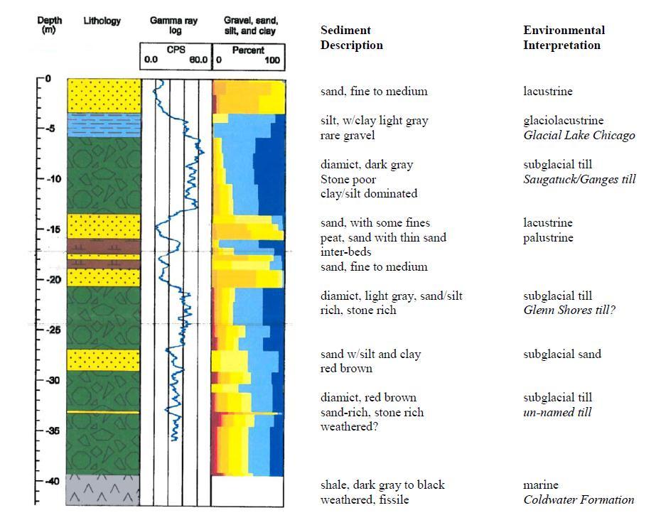
6 Zumberge, J.H. and Benninghoff, W.S. (1969). A Mid-Wisconsin Peat in Michigan U.S.A. Pollen et Spores 11, John Ball Park Section Saugatuck/Ganges till (~8.5 meters) Sand (outwash) (0 to ~2 meters) peat & organic beds (>40,000 years old) (~1.0 meter) sand, silt, clay w/organics? (~1.0 meter) massive sand (~2.75 meters) silt and clay (0 to ~0.75 meters) Glenn Shores till
7 Ottawa County, Michigan Hemlock Crossing County Park Core (OT-12-01) N 5 km

8 drilling site

9 Rotosonic drilling at Hemlock Crossing County Park in late July 2012
10
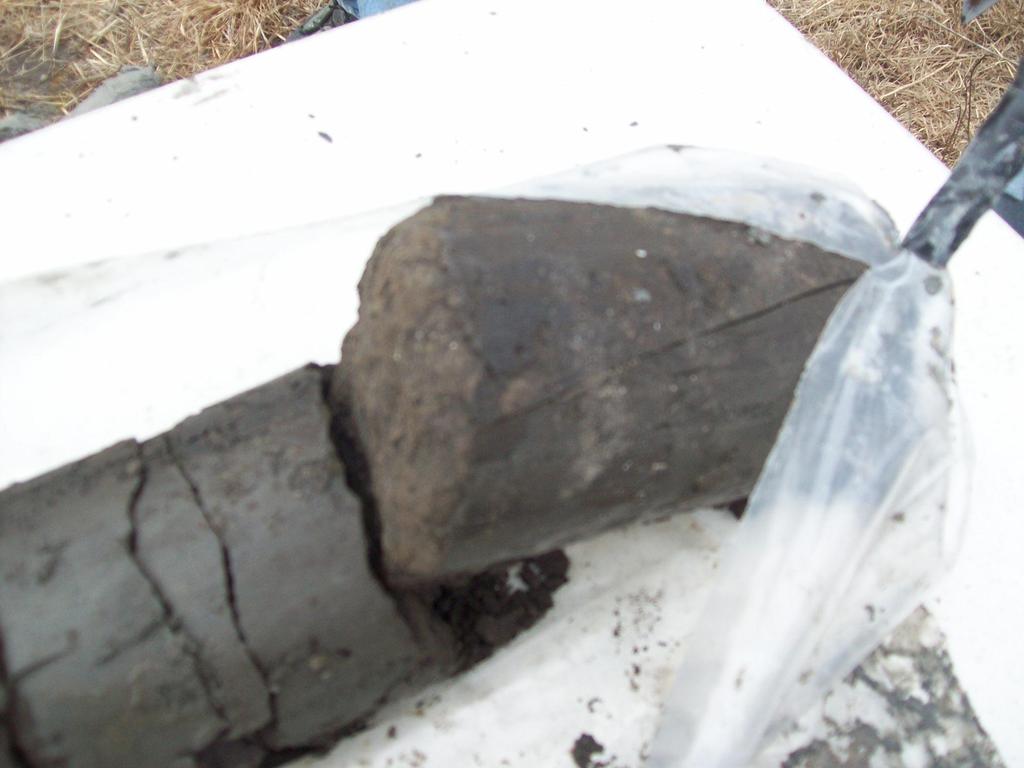
11

12 Derrick Lingle photo
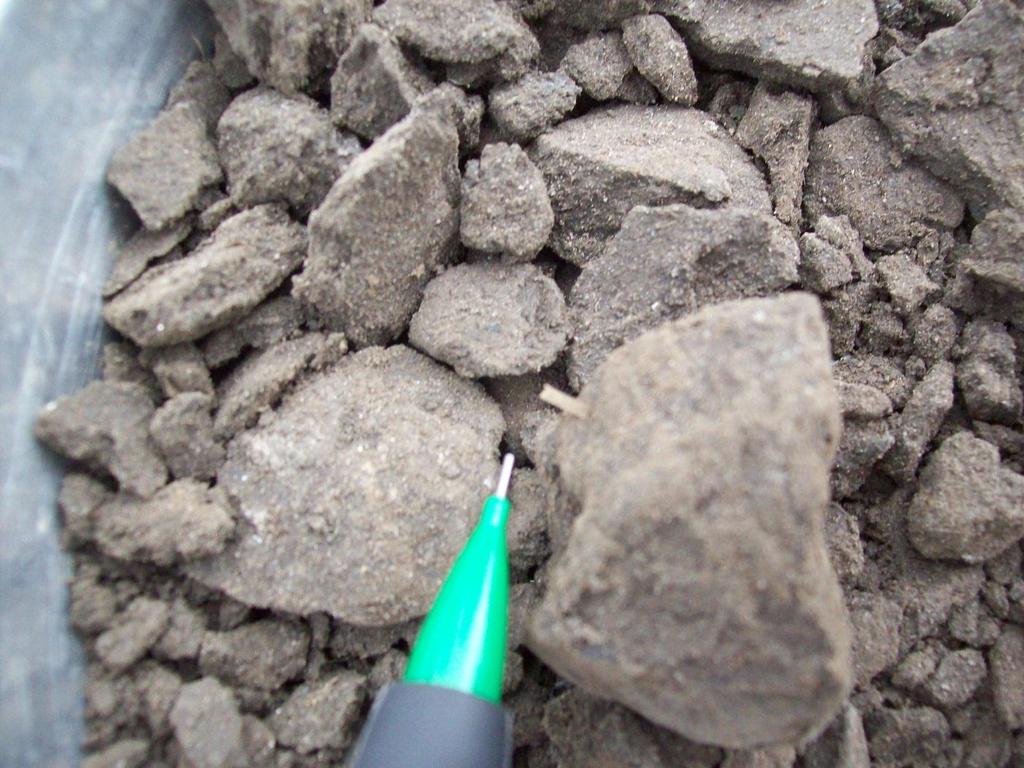
13

14 Wood and plant fragments separated and ready to be radiocarbon dated At Beta Analytic Radiocarbon Laboratory
15 42,950 to 41,920 Cal BP
16 45,000 Radiocarbon analyses at Glenn Shores and Hemlock Crossing Park Beta-3310 red bars are two sigma uncertainty 44,000 43,000 42,000 42,700 Beta ,930 Beta ,460 41,000 40,000 Glenn Shores Section* Glenn Shores ages were calibrated using CalPal online calculator Hemlock Crossing *Glenn Shores radiocarbon analyses are from Larson & Monaghan (1988). Lake phases and glacio-fluvial sequences of the Lake Michigan Basin: Southwestern Michigan, in Larson, G. and Monaghan W. (eds.). Wisconsin and Holocene Stratigraphy in Southwestern Michigan. Midwest Friends of the Pleistocene 35 th Field Conference Field Guide.
 N")
17 Wells to Bedrock Blue = Michigan Formation Yellow = Marshall Formation Black = Coldwater Formation Hemlock Crossing County Park Core (OT-12-01) N 5 km
18 Water Wells with organic sand units Red = Below Saugatuck Till Green = in Wisconsin Episode Sand Blue = in Holocene Sand Hemlock Crossing County Park Core (OT-12-01) N 5 km
19 Table 1 Thickness of sand and organic layer in Ottawa County, Michigan organic sand/silt thickness elevation of top of organic sand depth of top of organic sand N Mean (meters) Min (meters) Max (meters) bedrock depth Note: Lake Michigan mean elevation (1860 to 2010) is ~176 meters a.m.s.l. (577 feet).
20 Conclusions & Implications Age of organics in sand is ~42,000 years BP (MIS-3). Average depth to bedrock is about 49 m below the land surface in Ottawa County and varies from 9 to 150 m depth below the surface. Average depth to bottom of organic bearing sand is about 24 m and varies from 5 to 51 m depth below the surface. Thickness of pre-mis-3 glacial sediments varies from about 4 to 102 meters, with a mean thickness of about 25 m. This implies that there is a significant thickness of glacial sediments older than MIS-3 in Ottawa and surrounding counties.
Michigan s Geology and Groundwater
 Michigan s Geology and Groundwater Ralph J. Haefner Deputy Director U.S. Geological Survey Michigan-Ohio Water Science Center Lansing, Michigan Outline About the USGS Geology 101 Michigan s geology Bedrock
Stratigraphic Framework and Landsystem Correlation for Deposits of the Saginaw Lobe, Michigan, USA
 Western Michigan University ScholarWorks at WMU Master's Theses Graduate College 6-2014 Stratigraphic Framework and Landsystem Correlation for Deposits of the Saginaw Lobe, Michigan, USA Ivan R. Guzman
The Geology of Sebago Lake State Park
 Maine Geologic Facts and Localities September, 2002 43 55 17.46 N, 70 34 13.07 W Text by Robert Johnston, Department of Agriculture, Conservation & Forestry 1 Map by Robert Johnston Introduction Sebago
Provenance of Loess on Long Island using single grain 40 Ar/ 39 Ar ages of muscovite
 Provenance of Loess on Long Island using single grain 4 Ar/ 39 Ar ages of muscovite Vesna Kundic a, Jian Zhong b, Sidney Hemming c, Gilbert N. Hanson a a Department of Geosciences, Stony Brook University,
Follow this and additional works at: Part of the Geology Commons
 Western Michigan University ScholarWorks at WMU Michigan Geological Repository for Research and Education Geosciences 2016 Geology of Michigan William B. Harrison III Michigan Geological Repository for
4. What type of glacier forms in a sloping valley between rock walls? a. firn glacier b. ice sheet c. cirque d. alpine glacier
 Multiple Choice Questions 1. The term means the loss of snow and ice by evaporation and melting. a. sublimation b. ablation c. erosion d. abrasion 2. What condition must be met for a glacier to begin flowing
Subsurface Geology of the Kennebec River
 Maine Geologic Facts and Localities July, 1998 Subsurface Geology of the Kennebec River 43 54 40.75 N, 69 48 29.01 W Text by Daniel B. Locke, Department of Agriculture, Conservation & Forestry 1 Map by
Moosehead Lake and the Tale of Two Rivers
 Maine Geologic Facts and Localities June, 2005 45 o 53 5.09 N, 69 o 42 14.54 W Text by Kelley, A.R.; Kelley, J.T.; Belknap, D.F.; and Gontz, A.M. Department of Earth Sciences, University of Maine, Orono,
GEOCHEMISTRY OF LOESS ON LONG ISALAND Vesna Kundić and Gilbert N. Hanson Department of Geosciences Stony Brook University
 GEOCHEMISTRY OF LOESS ON LONG ISALAND Vesna Kundić and Gilbert N. Hanson Department of Geosciences Stony Brook University Loess is unconsolidated, wind deposited sediment composed mainly of silt-sized
The Building of the NYC Region
 The Building of the NYC Region Definitions Fall Line marks the area where an upland region (continental bedrock) and a coastal plain meet Piedmont the plateau region of the eastern United States which
MICHIGAN GEOLOGICAL SURVEY Coastal Navigator Training St. Joseph, Michigan What do we know about anthropogenic impact(s) to Lake Michigan shorelines?
 to Lake Michigan shorelines?") MICHIGAN GEOLOGICAL SURVEY Coastal Navigator Training St. Joseph, Michigan What do we know about anthropogenic impact(s) to Lake Michigan shorelines? Review of a 12 year shoreline study and today, what
MICHIGAN GEOLOGICAL SURVEY Coastal Navigator Training St. Joseph, Michigan What do we know about anthropogenic impact(s) to Lake Michigan shorelines? Review of a 12 year shoreline study and today, what
Lake Levels and Climate Change in Maine and Eastern North America during the last 12,000 years
 Maine Geologic Facts and Localities December, 2000 Lake Levels and Climate Change in Maine and Eastern North America during the last 12,000 years Text by Robert A. Johnston, Department of Agriculture,
Surficial Geology of Oak Hill Quadrangle
 Illinois Preliminary Geologic Map IPGM Oak Hill-SG Surficial Geology of Oak Hill Quadrangle Peoria County, Illinois François Hardy and C. Pius Weibel 2008 ILLINOIS STATE GEOLOGICAL SURVEY E. Donald McKay
Name: Mid-Year Review #2 SAR
 Name: Mid-Year Review #2 SAR Base your answers to questions 1 through 3 on on the diagram below, which shows laboratory materials used for an investigation of the effects of sediment size on permeability,
Ground-Water Exploration in the Worthington Area of Nobles County: Summary of Seismic Data and Recent Test Drilling Results
 Ground-Water Exploration in the Worthington Area of Nobles County: Summary of Seismic Data and Recent Test Drilling Results Jim Berg and Todd Petersen Geophysicists, DNR Waters January 2000 Table of Contents
Radioactivity as a Basis for Correlation of Glacial Deposits in Ohio
 The Ohio State University Knowledge Bank kb.osu.edu Ohio Journal of Science (Ohio Academy of Science) Ohio Journal of Science: Volume 57, Issue 6 (November, 1957) 1957-11 Radioactivity as a Basis for Correlation
Surficial Geology of the South ½ Decatur and South ½ Marcellus 7.5 Minute Quadrangles, Cass and St. Joseph Counties, Michigan; Award No.
 TECHNICAL REPORT Surficial Geology of the South ½ Decatur and South ½ Marcellus 7.5 Minute Quadrangles, Cass and St. Joseph Counties, Michigan; Award No. #G 16AC00377 Michigan Geological Survey, Western
HYBRID DETERMINISTIC AND STOCHASTIC HYDROSTRATIGRAPHIC MODELING OF A COMPLEX GLACIAL AQUIFER SYSTEM
 HYBRID DETERMINISTIC AND STOCHASTIC HYDROSTRATIGRAPHIC MODELING OF A COMPLEX GLACIAL AQUIFER SYSTEM Lawrence D. Lemke, Andrew L. Frahm, Lena K. Pappas Department of Geology, Wayne State University, Detroit,
Surficial Geology of Dunlap Quadrangle
 Illinois Preliminary Geologic Map IPGM Dunlap-SG Surficial Geology of Dunlap Quadrangle Peoria County, Illinois François Hardy and C. Pius Weibel 2008 ILLINOIS STATE GEOLOGICAL SURVEY E. Donald McKay III,
Geology and New England Landscapes
 Geology and New England Landscapes Jim Turenne, CPSS USDA-NRCS Warwick, RI. http://nesoil.com Why Geology? Provides the big picture of site conditions. Major part of soil formation (parent material and
THE QUATERNARY GEOLOGY OF NEWARK BAY AND KILL VAN KULL CHANNEL, NEW YORK AND NEW JERSEY. and
 THE QUATERNARY GEOLOGY OF NEWARK BAY AND KILL VAN KULL CHANNEL, NEW YORK AND NEW JERSEY Stephanie Beda, W. Bruce Ward, William Murphy, Robert Fleming, Gary Fleming, Beckett Boyd Earthworks LLC 27 Glen
Surficial Geology of Antioch Quadrangle
 Illinois Preliminary Geologic Map IPGM Antioch-SG Surficial Geology of Antioch Quadrangle Lake County, Illinois and Kenosha County, Wisconsin Andrew J. Stumpf and Michael L. Barnhardt 2005 Department of
A surficial. P^HiHI waste disposal site, Bureau County, Illinois. east of the Sheffield low-level radioactive. electrical resistivity survey
 ISGS CONTRACT/GRANT REPORT 1981-6 WATER RESOURCES DIVISION/USGS P^HiHI 100240 557.09773 IL6cr 1981-6 A surficial electrical resistivity survey east of the Sheffield low-level radioactive waste disposal
THE OHIO JOURNAL OF SCIENCE
 THE OHIO JOURNAL OF SCIENCE VOL. LIII MARCH, 1953 No. 2 SUBSURFACE STUDY OF GLACIAL DEPOSITS AT CLEVELAND, OHIO C. T. BAGLEY Sverdrup & Parcel, Inc., Consulting Engineers, St. Lotus, Mo. The soil 1 strata
Lower Mainland Surficial Geology From Wisconsin Ice Age to Protocol 21
 Lower Mainland Surficial Geology From Wisconsin Ice Age to Protocol 21 BCEIA BEST Conference 2018 Whistler, BC Kalina Malowany and Virginie Brunetaud Presentation Outline 1. Surficial Geology it s more
W he natural resources of Adams
 Above: Houghton Rock, Town of Adams. Following Page: "The Hole in the Rock" on Rattlesnake Mound--both remnants of rock formed by ancient seas hundreds of millions of year5 ago. (Courtesy, H.H. Bennett
Prehistoric Clay Sources: A Forensic Exercise in Geoarchaeology
 Prehistoric Clay Sources: A Forensic Exercise in Geoarchaeology Lynn Ketterhagen Faculty Sponsor: Dean Wilder, Department of Geography and Earth Science ABSTRACT The prehistoric Oneota culture of the Upper
Diagnostic Geomorphic Methods for Understanding Future Behavior of Lake Superior Streams What Have We Learned in Two Decades?
 Diagnostic Geomorphic Methods for Understanding Future Behavior of Lake Superior Streams What Have We Learned in Two Decades? Faith Fitzpatrick USGS WI Water Science Center, Middleton, WI fafitzpa@usgs.gov
,Baynes Lake. TO...?&.?...A 2...KO.?'!!&... Sr. *logical Engineer
 > i evernment OF BRITISH COLUMBIA a TO...?&.?...A 2....KO.?'!!&... Sr. *logical Engineer... Grou,,water. Section Hydrology Division Wat.er... In~.~s.tiga.ti.On.s..Branck.... 5 u BJECT...C;.roun.dw.ater...Snve
THE OHIO JOURNAL OF SCIENCE
 THE OHIO JOURNAL OF SCIENCE VOL. LI JANUARY 1951 No. 1 SHORE EROSION ON SANDUSKY BAY PAUL R. SHAFFER Department of Geology, University of Illinois, Urbana, 111. The south shore of San dusky Bay is undergoing
The Montauk Peninsula: Data and Preliminary Interpretations of the Ditch Plains Area Introduction
 The Montauk Peninsula: Data and Preliminary Interpretations of the Ditch Plains Area John A. Black GSI Patchogue, New York R.S. Welch Suffolk Community College Selden, New York Introduction Sirkin, (1982)
Soils in Minnesota Calcareous Fens
 Soils in Minnesota Calcareous Fens MGWA TECHNICAL WORKSHOP June 18, 2004 George Poch 6/23/2004 1 Introduction Our presentation today is to show What soils are in the Fen areas How they have been mapped
Glacial Geology of Moose Point State Park, ME
 Geologic Site of the Month May, 2013 Glacial Geology of Moose Point State Park, Maine 44 o 25 59.18"N, 68 o 56 37.11"W Text and photos by Woodrow B. Thompson, Department of Agriculture, Conservation &
Basin Analysis Applied to Modelling Buried Valleys in the Great Lakes Basin
 EARTH SCIENCES SECTOR GENERAL INFORMATION PRODUCT 35 Basin Analysis Applied to Modelling Buried Valleys in the Great Lakes Basin Sharpe, D R; Russell, H A J 2004 Originally released as: Basin Analysis
Low-altitude organic deposits in Michigan: Evidence for pre-woodfordian Great Lakes and paleosurfaces
 Low-altitude organic deposits in Michigan: Evidence for pre-woodfordian Great Lakes and paleosurfaces RICHARD L. RIECK Department of Geology and Department of Geography, Western Illinois University, Macomb,
A RADIOCARBON DATE From Smoky Lake/ Alberta
 ----------------------------.~ RESEARCH COUNCIL OF ALBERTA Preliminary Report 56-3 A RADIOCARBON DATE From Smoky Lake/ Alberta by c. P. GRAVENOR AND B. ELLWOOD Price 25 Cents ., RESEARCH COUNCIL OF AIBERTA
DATA REPOSITORY ITEM FOR: Expansion of alpine glaciers in Pacific North America in the first millennium A.D.
 Reyes et al., p. 1 DATA REPOSITORY ITEM FOR: Expansion of alpine glaciers in Pacific North America in the first millennium A.D. Site TABLE DR1. LOCATION OF GLACIER STUDY SITES Location Latitude Longitude
APPENDIX G GLOSSARY. Mn/DOT/WR-0200
 APPENDIX G GLOSSARY Mn/DOT/WR-0200 Alluvial - comprised of clay, silt, sand, gravel, and/or other detritus deposited by water. Usually refers to accretionary overbank, floodplain or levee deposits. Biomantling
Chapter 5: Glaciers and Deserts
 I. Glaciers and Glaciation Chapter 5: Glaciers and Deserts A. A thick mass of ice that forms over land from the compaction and recrystallization of snow and shows evidence of past or present flow B. Types
Correlation of Tills Exposed in Toledo Edison Dam Cut, Ohio
 The Ohio State University Knowledge Bank kb.osu.edu Ohio Journal of Science (Ohio Academy of Science) Ohio Journal of Science: Volume 60, Issue 2 (March, 1960) 1960-03 Correlation of Tills Exposed in Toledo
HYDROGEOLOGIC FRAMEWORK OF LONG ISLAND'S NORTH FORK, SUFFOLK COUNTY, NEW YORK
 HYDROGEOLOGIC FRAMEWORK OF LONG ISLAND'S NORTH FORK, SUFFOLK COUNTY, NEW YORK Christopher E. Schubert 1, Richard E. Bova 2, and Paul E. Misut 1 1 U.S. Geological Survey, 2045 Route 112, Building 4, Coram,
Topic 6: Weathering, Erosion and Erosional-Deposition Systems (workbook p ) Workbook Chapter 4, 5 WEATHERING
 Workbook Chapter 4, 5 WEATHERING") Topic 6: Weathering, Erosion and Erosional-Deposition Systems (workbook p. 95-125) Workbook Chapter 4, 5 THE BIG PICTURE: Weathering, erosion and deposition are processes that cause changes to rock material
Topic 6: Weathering, Erosion and Erosional-Deposition Systems (workbook p. 95-125) Workbook Chapter 4, 5 THE BIG PICTURE: Weathering, erosion and deposition are processes that cause changes to rock material
Timing and magnitude of late Pleistocene and Holocene glaciations in Yosemite National Park
 National Park Service U.S. Department of the Interior Yosemite National Park Timing and magnitude of late Pleistocene and Holocene glaciations in Yosemite National Park Greg Stock Yosemite National Park
Lecture Outlines PowerPoint. Chapter 6 Earth Science 11e Tarbuck/Lutgens
 Lecture Outlines PowerPoint Chapter 6 Earth Science 11e Tarbuck/Lutgens 2006 Pearson Prentice Hall This work is protected by United States copyright laws and is provided solely for the use of instructors
Holocene Meander Incision Imposed Across a Buried Valley Wall
 Holocene Meander Incision Imposed Across a Buried Valley Wall Michael P. Wilson Geosciences Department SUNY College at Fredonia Fredonia, NY 14063 (716/673-3843) and William T. Boria Division of Environmental
Northwest Geological Society Society Field Trips in Pacific Northwest Geology
 Northwest Geological Society Society Field Trips in Pacific Northwest Geology Field Trip Guidebook # 10 Quaternary Geology of the Tacoma Area June 26-27 1999 Kathy G. Troost Derek B. Booth Patrick Pringle
CJ AREA MAPPED IN 1978 FOR QUATERNARY GEOLOGY ~ AREA MAPPED IN FOR QUATERNARY GEOLOGY. I I I j I I I -44-
 -44- ~. ~/
STUDY GUIDE FOR CONTENT MASTERY. Surface Water Movement
 Surface Water SECTION 9.1 Surface Water Movement In your textbook, read about surface water and the way in which it moves sediment. Complete each statement. 1. An excessive amount of water flowing downslope
Precambrian, Banded Iron Formation (Negaunee Formation) along US-41/M28, south of Coon Lake, Baraga County, Michigan
 along US-41/M28, south of Coon Lake, Baraga County, Michigan") Precambrian, Banded Iron Formation (Negaunee Formation) along US-41/M28, south of Coon Lake, Baraga County, Michigan Written By: Steven D.J. Baumann G-122013-1A Banded Iron Formation on the north side
Precambrian, Banded Iron Formation (Negaunee Formation) along US-41/M28, south of Coon Lake, Baraga County, Michigan Written By: Steven D.J. Baumann G-122013-1A Banded Iron Formation on the north side
QUATERNARY AND GLACIAL GEOLOGY
 QUATERNARY AND GLACIAL GEOLOGY JURGEN EHLERS Geologisches Landesamt, Germany Translated from Allgemeine und historische Quartdrgeologie English version by Philip L. Gibbard JOHN WILEY & SONS Chichester
Determining the Direction of Ice Advance Forming the Roanoke Point Moraine From a Survey of Hartford Basin Erratics
 Determining the Direction of Ice Advance Forming the Roanoke Point Moraine From a Survey of Hartford Basin Erratics J Bret Bennington 1 and Tim Young 2 1 Department of Geology, 114 Hofstra University,
Groundwater in Bayfield County
 Groundwater in Bayfield County Presented to Bayfield County Large Scale Livestoc Study Committee April 23, 2015 Madeline Gotowitz Hydrogeologist Groundwater in Bayfield County Groundwater basics Hydrogeology
Surficial Geologic Mapping Proposal for STATEMAP FY2019
 Surficial Geologic Mapping Proposal for STATEMAP FY2019 presented by David Grimley Illinois State Geological Survey Prairie Research Institute, University of Illinois IGMAC meeting, September 6 th, 2018
June 9, R. D. Cook, P.Eng. Soils Engineer Special Services Western Region PUBLIC WORKS CANADA WESTERN REGION REPORT ON
 PUBLIC WORKS CANADA WESTERN REGION REPORT ON GEOTECHNICAL INVESTIGATION PROPOSED MARTIN RIVER BRIDGE MILE 306.7 MACKENZIE HIGHWAY Submitted by : R. D. Cook, P.Eng. Soils Engineer Special Services Western
Geology of Ireland. Topography of Ireland. Irish topography. Solid Geology. The Impact of Geology on some National Road Schemes.
 The Impact of Geology on some National Road Schemes IGI Conference, Dublin Castle Dr Eric R Farrell Department of Civil, Structural and Environmental Engineering, Dublin University, Trinity College Geology
Waterbury Dam Disturbance Mike Fitzgerald Devin Rowland
 Waterbury Dam Disturbance Mike Fitzgerald Devin Rowland Abstract The Waterbury Dam was completed in October 1938 as a method of flood control in the Winooski Valley. The construction began in April1935
Jim Turenne. Soils on Social Media
 Jim Turenne USDA-NRCS 60 Quaker Lane, Suite 46 Warwick, RI. 02886 401-822-8832 Jim.turenne@ri.usda.gov Soils on Social Media www.twitter.com/soilsne www.fb.com/soilsne www.nesoil.com U.S. Department of
SL GEOLOGY AND MINING. Coal bearing strata in the project area are referable primarily to the Allegheny Group of
 SL-145-1 GEOLOGY AND MINING Coal bearing strata in the project area are referable primarily to the Allegheny Group of Pennsylvania age. These rocks occur as dissected remnants overlying the ridge-forming
Resume components. Assignments due Monday. Shape of Puget Sound. Formation and bathymetry
 Assignments due Monday Resume Top four choices of projects, in order of preference One paragraph proposal about topic of choice Weekly schedule Topics you d like to cover in class Math: Complete the calculus
QUANTIFYING CORRELATION IN THREE-DIMENSIONAL GEOLOGIC MAPPING OF GLACIAL DRIFT
 QUANTIFYING CORRELATION IN THREE-DIMENSIONAL GEOLOGIC MAPPING OF GLACIAL DRIFT John J. Quinn 1 and Howard D Moores 2 1 Argonne National Laboratory, Argonne, IL, USA quinnj@anl.gov 2 Department of Geosciences,
Landscape. Review Note Cards
 Landscape Review Note Cards Last Ice Age Pleistocene Epoch that occurred about 22,000 Years ago Glacier A large, long lasting mass of ice which forms on land and moves downhill because of gravity. Continental
THE BEDROCK SURFACE AND FORMER DRAINAGE SYSTEMS OF MONTGOMERY COUNTY, OHIO 1
 THE BEDROCK SURFACE AND FORMER DRAINAGE SYSTEMS OF MONTGOMERY COUNTY, OHIO 1 STANLEY E. NORRIS, Geologist, U. S. Geological Survey, Columbus, Ohio INTRODUCTION The bedrock surface of Montgomery County,
 Page 1 of 9 Name: Base your answer to the question on the diagram below. The arrows show the direction in which sediment is being transported along the shoreline. A barrier beach has formed, creating a
Reconstruction of glacial Lake Hind in southwestern Manitoba, Canada
 Journal of Paleolimnology 17: 9 21, 1997. 9 c 1997 Kluwer Academic Publishers. Printed in Belgium. Reconstruction of glacial Lake Hind in southwestern Manitoba, Canada C. S. Sun & J. T. Teller Department
Prentice Hall EARTH SCIENCE
 Prentice Hall EARTH SCIENCE Tarbuck Lutgens Chapter 7 Glaciers, Desert, and Wind 7.1 Glaciers Types of Glaciers A glacier is a thick ice mass that forms above the snowline over hundreds or thousands of
Correlation of gravel deposits from trenching project on Alder Creek fluvial terrace near Point Arena, California
 Correlation of gravel deposits from trenching project on Alder Creek fluvial terrace near Point Arena, California Aletha Lee Department of Geology and Geography, West Virginia University, White Hall, Morgantown,
16 AUGUST (Monday) Glacial Sediment
 Glacial Sediment") Presented By: U.S. Army Corps of Engineers, Detroit District Great Lakes Hydraulics and Hydrology Office With Support from the Great Lakes Commission 16 AUGUST (Monday) Glacial Sediment 9:00 9:30 Introduction
Presented By: U.S. Army Corps of Engineers, Detroit District Great Lakes Hydraulics and Hydrology Office With Support from the Great Lakes Commission 16 AUGUST (Monday) Glacial Sediment 9:00 9:30 Introduction
Overview of fluvial and geotechnical processes for TMDL assessment
 Overview of fluvial and geotechnical processes for TMDL assessment Christian F Lenhart, Assistant Prof, MSU Research Assoc., U of M Biosystems Engineering Fluvial processes in a glaciated landscape Martin
Page 1. Name:
 Name: 1) Which property would best distinguish sediment deposited by a river from sediment deposited by a glacier? thickness of sediment layers age of fossils found in the sediment mineral composition
Guided Notes Surface Processes. Erosion & Deposition By: Glaciers
 Guided Notes Surface Processes Erosion & Deposition By: Glaciers K. Coder 2015 26) How does moving ice erode and deposit sediments? Glaciers (Movement of Ice): a naturally formed mass of ice and snow that
Geology of Havering-atte-Bower
 Geology of Havering-atte-Bower The geology of Havering village consists of deposits of clays, gravels and sands variously classed as bedrock and superficial deposits. Clays and sands seem rather dull but
Bulletin of Earth Sciences of Thailand
 Quantitative Seismic Geomorphology of Early Miocene to Pleistocene Fluvial System of Northern Songkhla Basin, Gulf of Thailand Oanh Thi Tran Petroleum Geoscience Program, Department of Geology, Faculty
Connecticut's Aquifers
 Page 1 of 5 DEP Search: Connecticut's Aquifers The technical definition of the word "aquifer" is: any geologic formation capable of yielding significant quantities of water to wells. By that definition,
Interpreting the Stratigraphic Record of Glacial Readvances Along the Hudson River at Manhattanville, New York City, NY
 Interpreting the Stratigraphic Record of Glacial Readvances Along the Hudson River at Manhattanville, New York City, NY Cheryl J. Moss, Mueser Rutledge Consulting Engineers, 14 Penn Plaza, New York, NY
iii CONTENTS vii ACKNOWLEDGMENTS EXECUTIVE SUMMARY INTRODUCTION Study Area Data Sources Preparation of Geologic Maps
 CONTENTS ACKNOWLEDGMENTS EXECUTIVE SUMMARY INTRODUCTION Study Area Data Sources Preparation of Geologic Maps GEOLOGY Bedrock Geology Succession and Distribution Structural Features Description of Bedrock
EROSION HAZARD OF MINNESOTA'S LAKE SUPERIOR SHORELINE. Carol A. Johnston Principal Investigator
 EROSION HAZARD OF MINNESOTA'S LAKE SUPERIOR SHORELINE Carol A. Johnston Principal Investigator Maps prepared by: James Salés, John Bonde, Tim Aunan, and Richard Raby Minnesota Sea Grant Research Bulletin
1. Any process that causes rock to crack or break into pieces is called physical weathering. Initial product = final product
 Weathering 1. Any process that causes rock to crack or break into pieces is called physical weathering. Initial product = final product End Result of physical weathering is increased surface area. 2. Physical
Soil Formation. Parent Material. Time. Climate
 Soil Formation Parent Material Time Climate Topography Biota Main Objectives 1. Gain a general understanding of soil formation processes 2. Understand the importance of mineral weathering in soil formation
Maggie Payne Jim Turenne
 Maggie Payne Jim Turenne USDA-NRCS 60 Quaker Lane, Suite 46 Warwick, RI. 02886 401-822-8832 maggie.payne@ri.usda.gov U.S. Department of Agriculture 1935: Soil Conservation Service (SCS) Natural Resources
Origin of the Blue Hills State Natural Area #74, Rusk County, Wisconsin
 Origin of the Blue Hills State Natural Area #74, Rusk County, Wisconsin by Andrew H. Thompson and Kent M. Syverson Department of Geology, University of Wisconsin, Eau Claire, WI 54702 (E-mail: syverskm@uwec.edu)
County Geologic Atlas and State Special Appropriations of the Minnesota Legislature and LCCMR USGS STATEMAP PROGRAM
 Continued work on using the horizontal-to-vertical spectral ratio (HVSR) passive seismic method for determining Quaternary sediment thickness in Minnesota Val W. Chandler and Richard S. Lively, Minnesota
Evidence for Permafrost on Long Island
 Evidence for Permafrost on Long Island By Vesna Kundic and Gilbert N. Hanson Department of Geosciences Stony Brook University Permafrost or permanently frozen ground is soil or rock that remains below
Project Area. Funded by the Illinois Department of Transportation Springfield, Illinois
 Three-dimensional Geologic Mapping for Transportation Planning in Central-northern northern Illinois: Data Selection, Map Construction, and Model Development Richard C. Berg, E. Donald McKay, Donald A.
Page 1. Name:
 Name: 1) Which event is the best example of erosion? dissolving of rock particles on a limestone gravestone by acid rain breaking apart of shale as a result of water freezing in a crack rolling of a pebble
Investigating the Presence of Pebbly Loess in Nassau County, Long Island and its Impact on Plant Life Joseph DeMarco
 Investigating the Presence of Pebbly Loess in Nassau County, Long Island and its Impact on Plant Life Joseph DeMarco JosephDeMarco90@gmail.com Abstract This research is to examine the presence of pebbly
Surficial Geology of Wauconda Quadrangle
 Illinois Preliminary Geologic Map IPGM Wauconda-SG 1:24,000 Surficial Geology of Wauconda Quadrangle Lake and McHenry Counties, Illinois Andrew J. Stumpf, Michael L. Barnhardt and Ardith K. Hansel Illinois
IGMAC 2015: Surficial Geologic Mapping STATEMAP past and future. Valparaiso Moraine, Will County
 IGMAC 2015: Surficial Geologic Mapping STATEMAP past and future Valparaiso Moraine, Will County presented by Drew Phillips, September 10. 2015 SURFICIAL MAPPING Completed Aug 2015 NE Illinois Project:
N 2 3. Lake Huron. St. Clair River. Black River Assessment. Figure 1. Major tributaries to the Black River. 1. Berry Drain 2. Elk Creek.
 1. Berry Drain 2. Elk Creek Deckerville 3. Arnot Creek 4. Black Creek 5. Silver Creek 6. Plum Creek 7. Mill Creek 1 Sandusky Carsonville 8. Stocks Creek Applegate N 2 3 Croswell Peck 0 5 10 Brown City
BOULDERS AND THE 2 TILL PROBLEM ON LONG ISLAND
 BOULDERS AND THE 2 TILL PROBLEM ON LONG ISLAND Introduction Herbert C. Mills 2015 33 Beacon Drive Port Washington, NY This paper examines 2 till sheets on Long Island, NY and uses an obvious difference
For Sale at $437,500.00
 We are pleased to present Carlson Farm 72.43 ± Acres Garden City Township, Blue Earth County For Sale at $437,500.00 Listing Agent: Darrell Hylen, ALC Office: 507-345-LAND (5263) Toll Free: 800-730-LAND
A Standardized Digital Well-Record Database for the Glaciated U.S.
 A Standardized Digital Well-Record Database for the Glaciated U.S. Randy Bayless and Les Arihood U.S. Geological Survey, Indiana Water Science Center, Indianapolis, IN Howard Reeves U.S. Geological Survey,
Laboratory Exercise #4 Geologic Surface Processes in Dry Lands
 Page - 1 Laboratory Exercise #4 Geologic Surface Processes in Dry Lands Section A Overview of Lands with Dry Climates The definition of a dry climate is tied to an understanding of the hydrologic cycle
Name: Class: Date: Multiple Choice Identify the letter of the choice that best completes the statement or answers the question.
 Name: Class: Date: geology ch 7 test 2008 Multiple Choice Identify the letter of the choice that best completes the statement or answers the question. 1. Which of the following is true about ice sheets?
Clast fabric in a Stony Brook campus moraine: Testing models for the process of glacial lobe dynamics
 Clast fabric in a Stony Brook campus moraine: Testing models for the process of glacial lobe dynamics Jennifer DePaoli, Charles Regulinski, Josh Timlin, Dan Davis and Elliot Klein Department of Geosciences
Surficial Geology of Mokena Quadrangle
 STATEMAP Mokena-SG Surficial Geology of Mokena Quadrangle Will and Cook Counties, Illinois Olivier J. Caron 16 Prairie Research Institute ILLINOIS STATE GEOLOGICAL SURVEY 615 East Peabody Drive Champaign,
Evidence of Glacial Readvances During Recession from the Last Glacial Maximum From the Citifield Stadium Site, Queens, New York City, NY
 Evidence of Glacial Readvances During Recession from the Last Glacial Maximum From the Citifield Stadium Site, Queens, New York City, NY Cheryl J. Moss, Mueser Rutledge Consulting Engineers, 14 Penn Plaza,
The Geology of Two Lights State Park. Cape Elizabeth, Maine
 Maine Geologic Facts and Localities June, 2002 Cape Elizabeth, Maine 43 33 33.48 N, 70 12 13.32 W Text by Henry N. Berry IV and Robert G. Marvinney, Department of Agriculture, Conservation & Forestry 1
Seismic Reflection Imaging across the Johnson Ranch, Valley County, Idaho
 Seismic Reflection Imaging across the Johnson Ranch, Valley County, Idaho Report Prepared for the Skyline Corporation Lee M. Liberty Center for Geophysical Investigation of the Shallow Subsurface (CGISS)
Figure 1. Overview map of stratigraphic units in east-central Wisconsin. Squares indicate locations of samples with pre-two Creeks radiocarbon dates
 Figure 1. Overview map of stratigraphic units in east-central Wisconsin. Squares indicate locations of samples with pre-two Creeks radiocarbon dates and circles indicate locations of samples with Two Creeks
Use of Engineering Properties to Identify Multiple Glacial Advances in New York City s Subsurface
 Use of Engineering Properties to Identify Multiple Glacial Advances in New York City s Subsurface Cheryl J. Moss, Mueser Rutledge Consulting Engineers, 14 Penn Plaza, New York, NY 10122 (cmoss@mrce.com)