Northwest Geological Society Society Field Trips in Pacific Northwest Geology
|
|
|
- Anna Page
- 6 years ago
- Views:
Transcription

1 Northwest Geological Society Society Field Trips in Pacific Northwest Geology Field Trip Guidebook # 10 Quaternary Geology of the Tacoma Area June Kathy G. Troost Derek B. Booth Patrick Pringle
2 This field trip guide has been re-formatted from the original document produced by the authors. All the original text and illustrations are reproduced here, and nothing has been added to the document in this process. All figures and images are reproduced at the same size as in the original document. 1 NWGS Field Guides are published by the Society with the permission of the authors, permission which is granted for personal use and educational purposes only. Commercial reproduction and sale of this material is prohibited. The NWGS assumes no responsibility for the accuracy of these guides, or for the author s authority to extend permission for their use. Of particular note, some stops on these trips may be located on private property. Publication of this guide does not imply that public access has been granted to private property. If there is a possibility that the site might be on private property, you should assume that this is the case. Always ask permission before entering private property. *Note- Some images in this guide have been slightly reduced in size to fit format requirements

3

4

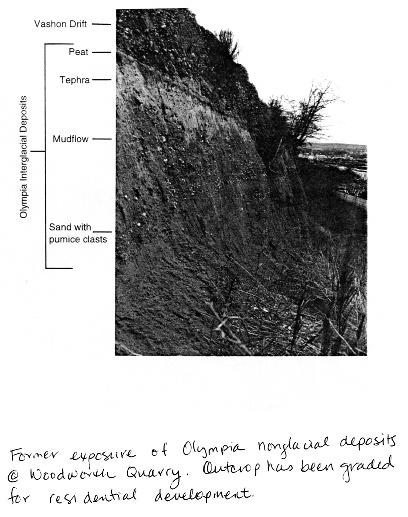
5 Quaternary Stratigraphy of the Tacoma Area Correlation and chronology of Quaternary deposits in the Tacoma area has long been a source of frustration for those working in the area. Much field and laboratory research, utilizing radiocarbon dating, paleomagnetic studies, tephrochronology, bulk geochemistry, thermoluminescence dating, fission track dating, and pollen and diatom analyses, is underway to establish the chronology and distribution of these and other critical Quaternary deposits. In addition, efforts are underway to confirm correlation of units here with the well-developed stratigraphy of southeast and northern Puget Sound (see strati graphic column). Most of the chronologic work on Quaternary stratigraphy has been accomplished by Easterbrook (1994) and his co-researchers. He compiled the following stratigraphic section for the Puget Lowland. Note that there is no named Olympia-age deposit on this section: The field trip will visit newly measured sections that span the Steilacoom Gravel of the Vashon Drift through deposits tentatively correlated with the Puyallup Formation. Emphasis will be on stratigraphic relationships and Quaternary history, evidence (or lack) of tectonic deformation, variability within individual strata, and impacts to local and regional groundwater patterns. Regional Geologic Setting The southern Puget Lowland has been glaciated at least six times during the Pleistocene Epoch (Easterbrook, 1994). The most recent, during the Vashon Stade of the Fraser Glaciation, was marked by the advance and retreat of the Puget Lobe of the Cordilleran Ice Sheet in western Washington. The glacier reached the central Puget Sound region about 15,000 14C years BP and retreated past this area by 13,650 14C years BP. Nonglacial deposits, where present, separate deposits of one glacier advance from another. Because the coastal mountains of British Columbia were the source area for each of the ice sheet advances, macroscopic lithology cannot be used to identify or differentiate the deposits of one glacial period from another glacial period. Because the Cascade volcanoes were primary sediment source areas during each nonglacial period in the Tacoma area, sediment lithology is probably not useful as a basis for differentiating the deposits of one nonglacial interval from those of another. nonglacial deposits. Note that some of the criteria only work in the south part of the Lowland. During glacial periods the apparent source of sediments is displaced to the north relative to nonglacial periods. In the Tacoma area, nonglacial sediments are predominantly derived from Mount Rainier and proto-mount Rainier to the southeast (see Table 3 below from Noble and Wallace, 1966). Glacial sediments, however, are dominated by lithologies with sources from the central and north Cascades more than 30 miles north. Similarly, nonglacial sediments that are exposed along Hood Canal on the western margin of the lowland are predominantly composed of lithologies from the Olympic Mountains, but glacial sediments are predominantly derived from the North Cascades (Borden, 1998). In the Seattle area during nonglacial times, rivers carry sediments from both the Mt. Rainier area and the central Cascades. These relationships are probably valid for glacial and nonglacial sediments throughout the lowland, although it may be locally complicated by the reworking of older glacial sediments during interglacial periods. Furthermore, the percentage of land area receiving deposition is small during nonglacial periods rela- Field Identification of Nonglacial Deposits Field recognition of nonglacial deposits depends heavily on the ability to differentiate glacial from nonglacial deposits. Because of the mixing that results from reworking of underlying deposits during a glacier advance and erosional/sedimentation cycles, differentiation of glacial from nonglacial deposits is unavoidably ambiguous. For end-member cases, however, several distinguishing characteristics are as follows. The following table (Troost and others, 1998) summarizes the criteria for differentiating glacial from

6 tive to glacial periods, as shown on the figure on the following page from Borden and Troost (1999).

7
8 CITATIONS AND OTHER REFERENCES Anundsen, K., Abella, S., Leopold, E., Stuiver, M., and Turner, S., 1994, Late-glacial and early Holocene sea-level fluctuations in the central Puget Lowland, Washington, inferred from lake sediments: Quaternary Research, v. 42, p Armstrong, J.E., Crandell D.R., Easterbrook, D.J., and Noble J.B., 1965, Late Pleistocene stratigraphy and chronology in southwestern British Columbia and northwestern Washington: Geological Society of America Bulletin, v. 76, p Beget, J.E., Keskinen, M.J., and Severin, K.P., 1997, Tephrochronologic constraints on the Late Pleistocene history of the southern margin of the Cordilleran ice sheet, western Washington: Quaternary Research, v. 47, p Blunt D.J., Easterbrook, D.J., and Rutter, N.W., 1987, Chronology of Pleistocene sediments in the Puget Lowland, Washington: Washington Division of Geology and Earth Resources Bulletin 77, p Booth, D.B., 1987, Timing and processes of deglaciation along the southern margin of the Cordilleran ice sheet: In W.F. Ruddimann and H.E. Wright, Jr., eds., North America and adjacent oceans during the last deglaciation Boulder, Colorado, Geological Society of America, Geology of North America, v. K-3, p Booth, D. B., 1994, Glaciofluvial infilling and scour of the Puget Lowland, Washington, during ice-sheet glaciation: Geology, v. 22, p Borden, R.K., and Troost, K.G., 1999 (in re view), Late Pleistocene Stratigraphy in the south-central Puget Lowland, West-Central Pierce County, Washington: Olympia, Washington State Department of Natural Resources, Open- File Report. Crandell, D. R., Mullineaux, D. R., and Waldron, H. H., 1958, Pleistocene sequence in the southeastern part of the Puget Sound Lowland, Washington: American Journal of Science, v. 256, p Deeter, J.D., 1979, Quaternary geology and stratigraphy of Kitsap County, Washington. Unpub M.S. thesis, Western Washington University. Dethier, D.P., Pessl, F., Keuler, R.F., Balzarini, M.A., and Pevear, D.R., 1995, Late Wisconsinan glaciomarine deposition and isostatic rebound, northern Puget Lowland, Washington: Geological Society of America Bulletin, v. 107, p Easterbrook, D.J., 1994, Chronology of pre-late Wisconsin Pleistocene sediments in the Puget Lowland, Washington: Washington Division of Geology and Earth Resources Bulletin 80, p Easterbrook, D. J., Crandell, D. R., and Leopold, E. B., 1967, Pre-Olympia Pleistocene stratigraphy and chronology in the central Puget Lowland, Washington: Geological Society of America Bulletin, v. 78, p Garling, M. E., Molenaar, D., Bailey, E. G., VanDenburgh, A. S., and Fiedler, G. H., 1965, Water resources and geology of the Kitsap Peninsula and certain adjacent islands: Washington Division of Water Resources Water-Supply Bulletin 18, 309 p. Leopold, E.B., Nickmann, R., Hedges, J.I., and Ertel, J.R., 1982, Pollen and lignin records of late Quaternary vegetation, Lake Washington: Science, v. 218, p Mullineaux, D.R., Waldron, H.H., and Rubin, M., 1965, Stratigraphy and chronology of late interglacial and early Vashon time in the Seattle area, Washington: U. S. Geological Survey Bulletin 1194-O, 10 p. Mullineaux, D.R., 1996, Pre-1980 tephra-fall deposits erupted from Mount St. Helens, Washington: U.S. Geological Survey Professional Paper 1563, 99 p. Noble, J.B., and Wallace, E.F., 1966, Geology and ground-water resources of Thurston County, Washington: Washington Division of Water Resources Water-Supply Bulletin No. 10, vol. 2, 141 p. Porter, S. C., and Swanson, T. W., 1996, Radiocarbon constraints on rates of advance and retreat of the Puget lobe during the last glaciation in the southeastern Puget Lowland: Quaternary environmental changes in the Pacific Northwest, Abstracts and program, University of Washington Quaternary Research Center Spring 1996 Workshop, p. 15. Rigg, G.B., and Gould, H.R., 1957, Age of Glacier Peak eruption and chronology of postglacial peat deposits in Washington and surrounding areas: American Journal of Science, v. 255, p Smith M., 1972, Stratigraphy and chronology of the Tacoma area, Washington. Unpub. M.S. thesis, Western Washington University. Troost, K.G., Booth, D.B., Sarna-Wojcicki, A., Meyer, C.E., and Hagstrum, J.T., 1997, Chronology, Mineralogy, and Correlation of Quaternary Tephra and Mudflow Deposits in the Central Puget Lowland, Washington State. In Abstracts with Programs, 1997 Annual Meeting, Geological Society of America, Salt Lake City, Utah, p. A-411. Troost, K.G., Mahoney, J.B., Booth, D.B., and Borden, R.K., 1998, Discriminating glacial from nonglacial sediments of the south-central Puget Lowland: Program with Abstracts, Annual Meeting, Seattle, WA, Sept 30-Oct 3, Association of Engineering Geologists, p. 130.
9 Walsh, T.J., 1987, Geologic map of the south half of the Tacoma quadrangle, Washington: Washington Division of Geology and Earth Resources Open File Report 87-3, 1:100,000. Walters, K.L. and G.E. Kimmel, 1968, Ground-Water occurrences and stratigraphy of unconsolidated deposits, Central Pierce County, Washington: Washington Department of Water Resources Water Supply Bulletin 22, 428 p. NEW GEOLOGIC MAPS OF THE TACOMA AREA IN PRESS, REVIEW, OR PREPARATION: Booth, D.B., and Troost, K.G., in review (submitted 12/98), Geologic map of the Olalla 7.5-minute quadrangle, Washington: U. S. Geological Survey, Open-File Report, scale 1:24,000. Booth, D. B., and Waldron, H. H., in press, Surficial Geologic Map of the Des Moines 7.5 Quadrangle, King County, Washington: U.S. Geological Survey Open-File Series Map, scale 1:24,000, 1 sheet, text. Booth, D.B., Waldron, H.H., and Troost, K.G., in press, Geologic map of the Poverty Bay 7.5-minute quadrangle, Washington: U. S. Geological Survey, Open-File Report, scale 1:24,000. Troost, K.G., in review (submitted 1/99), Geologic map of the Puyallup 7.5-minute quadrangle, Washington: U. S. Geological Survey, Open-File Report, scale 1:24,000. Troost, K.G., in review (submitted 10/97), Geologic map of the Tacoma South 7.5-minute quadrangle, Washington: U. S. Geological Survey, Open-File Report, scale 1:24,000. Troost, K.G. and Booth, D.B., in preparation (submission for review 12/99), Geologic map of the Gig Harbor 7.5-minute quadrangle, Washington: U. S. Geological Survey, Open-File Report, scale 1:24,000. Troost, K.G. and Booth, D.B., in review (submitted 1/99), Geologic map of the Tacoma North 7.5-minute quadrangle, Washington: U. S. Geological Survey, Open-File Report, scale 1:24,000. Troost, K.G., Booth, D.B., and Borden, R.K., in review (submitted 10/97), Geologic map of the Steilacoom 7.5-minute quadrangle, Washington: U. S. Geological Survey, Open-File Report, scale 1:24,000.
10
11

12

13

14

15
16
17

18

19

20

21
22
23 This locality displays a classic relationship between the main Vashon glacial units. The Vashon till (Qvt) drapes the upland surface, but it has been locally eroded by the action of recessional meltwater (leaving deposit Qvr). Nalley Valley is one of the major channels that connected different arms of the proglacial recessional lake that drained through progressively lower spillways into Lake Russell, and from there south over the Black Hills into the Chehalis River. Beneath the recessional and till lies sand and gravel of the Vashon advance outwash (Qva), which constitues most of the topographic relief present in the modern landscape.
24 In the Tacoma area, multiple recessional channels served as spillways, allowing water to drain southwest from glacial Lake Puyallup into the main proglacial lake along the axis of the Puget Lowland (glacial Lake Russell) and thence out through the Black Hills and into the Chehalis River. The following figure (from Walters and Kimmel, 1968) shows the locations of some of the more pronounced channels linking the two glacial lakes. As the ice receded to the north, progressively lower channels were exposed and so were occupied by meltwater.

25
26

27
28
29

30
31

32
33
34
35
Resume components. Assignments due Monday. Shape of Puget Sound. Formation and bathymetry
 Assignments due Monday Resume Top four choices of projects, in order of preference One paragraph proposal about topic of choice Weekly schedule Topics you d like to cover in class Math: Complete the calculus
Pleistocene tephrostratigraphy and paleogeography of southern Puget Sound near Olympia, Washington
 Geological Society of America Field Guide 4 2003 Pleistocene tephrostratigraphy and paleogeography of southern Puget Sound near Olympia, Washington Timothy J. Walsh Michael Polenz Robert L. (Josh) Logan
Lower Mainland Surficial Geology From Wisconsin Ice Age to Protocol 21
 Lower Mainland Surficial Geology From Wisconsin Ice Age to Protocol 21 BCEIA BEST Conference 2018 Whistler, BC Kalina Malowany and Virginie Brunetaud Presentation Outline 1. Surficial Geology it s more
Late Pleistocene Stratigraphy in the South-Central Puget Lowland, Pierce County, Washington
 N A T U R A L R E S O U R C E S Late Pleistocene Stratigraphy in the South-Central Puget Lowland, Pierce County, Washington by Richard K. Borden and Kathy Goetz Troost WASHINGTON DIVISION OF GEOLOGY AND
The Seattle-area geologic mapping project and the geologic framework of Seattle
 The Seattle-area geologic mapping project and the geologic framework of Seattle Troost, K.G., D.B. Booth, S.A. Shimel, and M.A. O Neal, Univ. of Washington, Seattle 98195 Introduction The Puget Lowland
April
 April 2016 5 993-1410-007.006 2.0 PHYSICAL SETTING AND HYDROGEOLOGY This section provides background information on the physical setting and hydrogeology of the Tumwater area based on previous investigations
Lat Long Associated paleomag site Age range Strike Dip Quadrangle T7027 Solo Point <45ka 0 0 McN
 Lat Long Associated paleomag site Age range Strike Dip Quadrangle 47.1374-122.6310 T7027 Solo Point
Lake Levels and Climate Change in Maine and Eastern North America during the last 12,000 years
 Maine Geologic Facts and Localities December, 2000 Lake Levels and Climate Change in Maine and Eastern North America during the last 12,000 years Text by Robert A. Johnston, Department of Agriculture,
KATHY GOETZ TROOST, L.G , th Drive SE, Snohomish, WA
 Curriculum Vitae KATHY GOETZ TROOST, L.G. 206-909-9757, kt@troostgeosciences.com 17227 97 th Drive SE, Snohomish, WA 98296-8163 Geologist with 34 years of experience conducting in-depth applied geologic
discussion of North America s physical features, including its landforms and bodies of
 Chapter 7 Natural Environments of North America Chapter 7 focuses on the natural environments of North America. The chapter opens with a discussion of North America s physical features, including its landforms
Moosehead Lake and the Tale of Two Rivers
 Maine Geologic Facts and Localities June, 2005 45 o 53 5.09 N, 69 o 42 14.54 W Text by Kelley, A.R.; Kelley, J.T.; Belknap, D.F.; and Gontz, A.M. Department of Earth Sciences, University of Maine, Orono,
Appendix F4.11 Geologic Unit Summaries, Hazard Areas, and Boring Locations
 Appendix F4.11 Geologic Unit Summaries, Hazard Areas, and Boring Locations Appendix F4.11 Geologic Unit Summaries and Hazard Areas TABLE F4.11-1 Summary of Geologic Units and their Engineering Properties
Evidence for distribution and thickness of Athens Sub-episode and older sediments in Ottawa County, Michigan
 Evidence for distribution and thickness of Athens Sub-episode and older sediments in Ottawa County, Michigan Patrick M. Colgan Department of Geology Grand Valley State University With thanks to Al Kehew
,Baynes Lake. TO...?&.?...A 2...KO.?'!!&... Sr. *logical Engineer
 > i evernment OF BRITISH COLUMBIA a TO...?&.?...A 2....KO.?'!!&... Sr. *logical Engineer... Grou,,water. Section Hydrology Division Wat.er... In~.~s.tiga.ti.On.s..Branck.... 5 u BJECT...C;.roun.dw.ater...Snve
Provenance of Loess on Long Island using single grain 40 Ar/ 39 Ar ages of muscovite
 Provenance of Loess on Long Island using single grain 4 Ar/ 39 Ar ages of muscovite Vesna Kundic a, Jian Zhong b, Sidney Hemming c, Gilbert N. Hanson a a Department of Geosciences, Stony Brook University,
THE JUAN DE FUCA LOBE OF THE CORDILLERAN ICE SHEET
 THE JUAN DE FUCA LOBE OF THE CORDILLERAN ICE SHEET There were two large glaciers in western Washington during the latest, or Vashon, glaciation of that region. Each was essentially an elongated lobe of
Page 1. Name:
 Name: 1) Which property would best distinguish sediment deposited by a river from sediment deposited by a glacier? thickness of sediment layers age of fossils found in the sediment mineral composition
The Geology of Sebago Lake State Park
 Maine Geologic Facts and Localities September, 2002 43 55 17.46 N, 70 34 13.07 W Text by Robert Johnston, Department of Agriculture, Conservation & Forestry 1 Map by Robert Johnston Introduction Sebago
THE BEDROCK SURFACE AND FORMER DRAINAGE SYSTEMS OF MONTGOMERY COUNTY, OHIO 1
 THE BEDROCK SURFACE AND FORMER DRAINAGE SYSTEMS OF MONTGOMERY COUNTY, OHIO 1 STANLEY E. NORRIS, Geologist, U. S. Geological Survey, Columbus, Ohio INTRODUCTION The bedrock surface of Montgomery County,
CURRICULUM VITAE. Terry W. Swanson Birth date: 15 March, 1960 Citizenship: United States
 CURRICULUM VITAE Terry W. Swanson Birth date: 15 March, 1960 Citizenship: United States Academic Training Ph.D., 1994, Geological Sciences, University of Washington, Seattle Washington. Ph.D. Dissertation:
IGMAC 2015: Surficial Geologic Mapping STATEMAP past and future. Valparaiso Moraine, Will County
 IGMAC 2015: Surficial Geologic Mapping STATEMAP past and future Valparaiso Moraine, Will County presented by Drew Phillips, September 10. 2015 SURFICIAL MAPPING Completed Aug 2015 NE Illinois Project:
SECTION 2 How Is Pacific Northwest Climate Changing?
 SECTION 2 How Is Pacific Northwest Climate Changing? The Pacific Northwest is experiencing a suite of long-term changes that are consistent with those observed globally as a result of human-caused climate
Evidence of Ice Retreat, East Shore of Sabattus Pond
 Maine Geologic Facts and Localities November, 2002 Evidence of Ice Retreat, East Shore of Sabattus Pond 44 7 25.14 N, 70 5 21.69 W Text by Michael E. Foley, Department of Agriculture, Conservation & Forestry
Surficial Geologic Mapping Proposal for STATEMAP FY2019
 Surficial Geologic Mapping Proposal for STATEMAP FY2019 presented by David Grimley Illinois State Geological Survey Prairie Research Institute, University of Illinois IGMAC meeting, September 6 th, 2018
Surficial Geology of Oak Hill Quadrangle
 Illinois Preliminary Geologic Map IPGM Oak Hill-SG Surficial Geology of Oak Hill Quadrangle Peoria County, Illinois François Hardy and C. Pius Weibel 2008 ILLINOIS STATE GEOLOGICAL SURVEY E. Donald McKay
Geologic Evolution of the Skagit River Channel Migration Zone. J. Riedel National Park Service
 Geologic Evolution of the Skagit River Channel Migration Zone J. Riedel National Park Service LSWT BT OT CMZ defined by: 1) Areas within FEMA floodplain of Skagit River (100 and 500 year); 2) Areas within
The Montauk Peninsula: Data and Preliminary Interpretations of the Ditch Plains Area Introduction
 The Montauk Peninsula: Data and Preliminary Interpretations of the Ditch Plains Area John A. Black GSI Patchogue, New York R.S. Welch Suffolk Community College Selden, New York Introduction Sirkin, (1982)
PHYSIOGRAPHIC REGIONS OF THE LOWER 48 UNITED STATES
 PHYSIOGRAPHIC REGIONS OF THE LOWER 48 UNITED STATES LAURENTIAN UPLAND 1. Superior Upland ATLANTIC PLAIN 2. Continental Shelf (not on map) 3. Coastal Plain a. Embayed section b. Sea Island section c. Floridian
Glacial Modification of Terrain
 Glacial Modification Part I Stupendous glaciers and crystal snowflakes -- every form of animate or inanimate existence leaves its impress upon the soul of man. 1 -Orison Swett Marden Glacial Modification
PHYSICAL GEOGRAPHY. By Brett Lucas
 PHYSICAL GEOGRAPHY By Brett Lucas GLACIAL PROCESSES Glacial Processes The Impact of Glaciers on the Landscape Glaciations Past and Present Types of Glaciers Glacier Formation and Movement The Effects of
CORRELATION OF CLIMATIC AND SOLAR VARIATIONS OVER THE PAST 500 YEARS AND PREDICTING GLOBAL CLIMATE CHANGES FROM RECURRING CLIMATE CYCLES
 Easterbrook, D.J., 2008, Correlation of climatic and solar variations over the past 500 years and predicting global climate changes from recurring climate cycles: International Geological Congress, Oslo,
Surficial Geology of Dunlap Quadrangle
 Illinois Preliminary Geologic Map IPGM Dunlap-SG Surficial Geology of Dunlap Quadrangle Peoria County, Illinois François Hardy and C. Pius Weibel 2008 ILLINOIS STATE GEOLOGICAL SURVEY E. Donald McKay III,
Glacial Deposition and Groundwater in Dutchess County
 Glacial Deposition and Groundwater in Dutchess County Name: Period: Thousands of years ago an enormous ice sheet blanketed the Hudson Valley in what was called the Wisconsinan Glaciation. The ice reshaped
Surface Process Hazards Unit 2: Landscape Feature Scavenger Hunt
 Surface Process Hazards Unit 2: Landscape Feature Scavenger Hunt Sarah Hall (College of the Atlantic) and Becca Walker (Mt. San Antonio College) The following pages each have a series of questions about
DATA REPOSITORY ITEM FOR: Expansion of alpine glaciers in Pacific North America in the first millennium A.D.
 Reyes et al., p. 1 DATA REPOSITORY ITEM FOR: Expansion of alpine glaciers in Pacific North America in the first millennium A.D. Site TABLE DR1. LOCATION OF GLACIER STUDY SITES Location Latitude Longitude
Reconstruction of glacial Lake Hind in southwestern Manitoba, Canada
 Journal of Paleolimnology 17: 9 21, 1997. 9 c 1997 Kluwer Academic Publishers. Printed in Belgium. Reconstruction of glacial Lake Hind in southwestern Manitoba, Canada C. S. Sun & J. T. Teller Department
Geologic Trips San Francisco and the Bay Area
 Excerpt from Geologic Trips San Francisco and the Bay Area by Ted Konigsmark ISBN 0-9661316-4-9 GeoPress All rights reserved. No part of this book may be reproduced without written permission in writing,
HYDROGEOLOGIC FRAMEWORK OF LONG ISLAND'S NORTH FORK, SUFFOLK COUNTY, NEW YORK
 HYDROGEOLOGIC FRAMEWORK OF LONG ISLAND'S NORTH FORK, SUFFOLK COUNTY, NEW YORK Christopher E. Schubert 1, Richard E. Bova 2, and Paul E. Misut 1 1 U.S. Geological Survey, 2045 Route 112, Building 4, Coram,
Name: Mid-Year Review #2 SAR
 Name: Mid-Year Review #2 SAR Base your answers to questions 1 through 3 on on the diagram below, which shows laboratory materials used for an investigation of the effects of sediment size on permeability,
2. What type of rocks would you expect in this area, based on the topography? What is your reasoning?
 Geology 101 Bonus Lab Name Topographic maps are useful in helping us interpret the history of the landscape of an area. The questions below are designed to help you learn to interpret topographic maps.
ALASKA GEOLOGICAL SOCIETY PUBLICATIONS Stratigraphic And Structure Sections
 ALASKA GEOLOGICAL SOCIETY PUBLICATIONS 2007-2008 Stratigraphic And Structure Sections Price Western Alaska Bristol Bay Region Stratigraphic Correlation Sections (CD)... $12.00 AGS Member Price... $10.00
Glacial Geology of Moose Point State Park, ME
 Geologic Site of the Month May, 2013 Glacial Geology of Moose Point State Park, Maine 44 o 25 59.18"N, 68 o 56 37.11"W Text and photos by Woodrow B. Thompson, Department of Agriculture, Conservation &
Evidence for Permafrost on Long Island
 Evidence for Permafrost on Long Island By Vesna Kundic and Gilbert N. Hanson Department of Geosciences Stony Brook University Permafrost or permanently frozen ground is soil or rock that remains below
Timing and processes of deglaciation along the southern margin of the Cordilleran ice sheet
 The Geology of North America Vol. K-3, North America and adjacent oceans during the last deglaciation The Geological Society of America, 1987 Chapter 4 Timing and processes of deglaciation along the southern
Orting Community College Proposal
 Orting Community College Proposal Cedric, Celina, Francine, Sarah, Samuel GEO CORP Located in Washington, 42 miles south of Seattle. Situated between two rivers on fertile plains. Built on lahar deposits.
Surficial Geology of Antioch Quadrangle
 Illinois Preliminary Geologic Map IPGM Antioch-SG Surficial Geology of Antioch Quadrangle Lake County, Illinois and Kenosha County, Wisconsin Andrew J. Stumpf and Michael L. Barnhardt 2005 Department of
QUATERNARY AND GLACIAL GEOLOGY
 QUATERNARY AND GLACIAL GEOLOGY JURGEN EHLERS Geologisches Landesamt, Germany Translated from Allgemeine und historische Quartdrgeologie English version by Philip L. Gibbard JOHN WILEY & SONS Chichester
Loess and dust. Jonathan A. Holmes Environmental Change Research Centre
 Loess and dust Jonathan A. Holmes Environmental Change Research Centre Why is dust important? Mineral dust is an important constituent of the solid load in Earth's atmosphere, the total atmospheric aerosol
Lecture Outline Lecture Outline Monday April 9-16, 2018 Questions? Announcements:
 Lecture Outline Lecture Outline Monday April 9-16, 2018 Questions? Announcements: Geology 101 Night Video: The Day After Tomorrow Hollywood disaster movie about the onset of a glacial period When: Monday
Basin Analysis Applied to Modelling Buried Valleys in the Great Lakes Basin
 EARTH SCIENCES SECTOR GENERAL INFORMATION PRODUCT 35 Basin Analysis Applied to Modelling Buried Valleys in the Great Lakes Basin Sharpe, D R; Russell, H A J 2004 Originally released as: Basin Analysis
Glacial-Marine Sedimentation
 Glacial-Marine Sedimentation Glacial-Marine Sedimentation Edited by Bruce F. Molnia Los Altos, California Plenum Press New York and London PREFACE This volume of 18 papers describes the glacial-marine
Determining the Direction of Ice Advance Forming the Roanoke Point Moraine From a Survey of Hartford Basin Erratics
 Determining the Direction of Ice Advance Forming the Roanoke Point Moraine From a Survey of Hartford Basin Erratics J Bret Bennington 1 and Tim Young 2 1 Department of Geology, 114 Hofstra University,
Plio-Pleistocene Geology
 UNIVERSITY OF SOUTH ALABAMA GY 112: Earth History Plio-Pleistocene Geology Instructor: Dr. Douglas W. Haywick Last Time A) Cenozoic Tectonics Western North American tectonic provinces Plateaus and canyons
ALASKA GEOLOGICAL SOCIETY PUBLICATIONS. Stratigraphic And Structure Sections
 ALASKA GEOLOGICAL SOCIETY PUBLICATIONS 2010 Stratigraphic And Structure Sections Price Western Alaska Bristol Bay Region Stratigraphic Correlation Sections (CD)...Item # WA01... $12.00 AGS Member Price...
to represent sediments deposited through a series of marine transgressive
 i Hydrogeol ogy of Sal tsprinq s1 and Two main assemblages of rocks directly underly Saltspring sland. The Napajmo Group of Upper Cretaceous aqe comprising sedimentary rocks lies in th, brthern half and
Guided Notes Surface Processes. Erosion & Deposition By: Glaciers
 Guided Notes Surface Processes Erosion & Deposition By: Glaciers K. Coder 2015 26) How does moving ice erode and deposit sediments? Glaciers (Movement of Ice): a naturally formed mass of ice and snow that
DON J. EASTERBROOK Department of Geology, Western Washington State College, Bellingfiam, Washington ABSTRACT
 DON J. EASTERBROOK Department of Geology, Western Washington State College, Bellingfiam, Washington 98225 Pleistocene Chronology of the Puget Lowland and San Juan Islands, Washington The Puget Lowland
Prentice Hall EARTH SCIENCE
 Prentice Hall EARTH SCIENCE Tarbuck Lutgens Chapter 7 Glaciers, Desert, and Wind 7.1 Glaciers Types of Glaciers A glacier is a thick ice mass that forms above the snowline over hundreds or thousands of
Released Science Inquiry Task Encounter with an Active Volcano Grade 11
 Date: Your Name: Released Science Inquiry Task Encounter with an Active Volcano 2016 Grade 11 Directions: Science You will be reading a story and analyzing the data provided to answer a set of questions.
Michigan s Geology and Groundwater
 Michigan s Geology and Groundwater Ralph J. Haefner Deputy Director U.S. Geological Survey Michigan-Ohio Water Science Center Lansing, Michigan Outline About the USGS Geology 101 Michigan s geology Bedrock
SD-100 SD-200 SITE AND EXPLORATION PLAN SODO SEGMENT. FIG. 3 Sheet 4 of 9. Seattle Monorail Project Seattle, Washington Scale in Feet
 Central Parking Lot potential downhole arrary location (site visit //) PREFERRED New Parking Area File: I: \Drafting \\- \plans \-- Plans.dwg Date: -- Author: LR Current downhole array location LEGEND
D DAVID PUBLISHING. The San Juan Islands Thrust System: New Perspectives from LIDAR and Sonar Imagery. 1. Introduction. Don J.
 Journal of Earth Science and Engineering 5 (2015) 1-26 doi: 10.17265/2159-581X/2015. 01. 001 D DAVID PUBLISHING The San Juan Islands Thrust System: New Perspectives from LIDAR and Sonar Imagery Don J.
Geology and New England Landscapes
 Geology and New England Landscapes Jim Turenne, CPSS USDA-NRCS Warwick, RI. http://nesoil.com Why Geology? Provides the big picture of site conditions. Major part of soil formation (parent material and
4. What type of glacier forms in a sloping valley between rock walls? a. firn glacier b. ice sheet c. cirque d. alpine glacier
 Multiple Choice Questions 1. The term means the loss of snow and ice by evaporation and melting. a. sublimation b. ablation c. erosion d. abrasion 2. What condition must be met for a glacier to begin flowing
What is a Glacier? Types of Glaciers
 Alpine & Continental Glaciers Glacial Mass Balance Glacial Ice Formation Glacial Movement & Erosion Erosional and Depositional Landforms The Pleistocene Epoch Geomorphology of SW Manitoba Chapter 17 1
Betsy Stevenson and Allison Mohrs (Skagit County Planning and Development Services) Jenny Baker, The Nature Conservancy
 Jenny Baker, The Nature Conservancy") TC Fisher Slough Final Design and Permitting Subject: Well Review Memorandum To: From: Betsy Stevenson and Allison Mohrs (Skagit County Planning and Development Services) Jenny Baker, The ature Conservancy
TC Fisher Slough Final Design and Permitting Subject: Well Review Memorandum To: From: Betsy Stevenson and Allison Mohrs (Skagit County Planning and Development Services) Jenny Baker, The ature Conservancy
Hydrogeologic Framework and Groundwater/Surface-Water Interactions of the Chehalis River Basin, Southwestern Washington
 Prepared in cooperation with the U.S. Army Corps of Engineers, Washington State Department of Ecology, and the Chehalis Basin Partnership Hydrogeologic Framework and Groundwater/Surface-Water Interactions
The Building of the NYC Region
 The Building of the NYC Region Definitions Fall Line marks the area where an upland region (continental bedrock) and a coastal plain meet Piedmont the plateau region of the eastern United States which
Geology of the Pacific Northwest
 Geology of the Pacific Northwest Pat Pringle photo, April 16, 1983 Group sedimentary northeast of Ashford of Eocene age
Gravel Transport Can Determine Late Flood Tectonics
 Chapter 23 Gravel Transport Can Determine Late Flood Tectonics The locations of all the quartzite gravel in the northwest states and adjacent Canada provide more information about the Flood than just reinforcing
Whidbey Island Glaciation
 Whidbey Island Glaciation During the last glaciation, the margin of the Cordilleran Ice Sheet (CIS) expanded from the Coast Mountains and Fraser Lowland of southwestern British Columbia into northwestern
The Palmer Hill Glacial-Marine Delta, Whitefield, Maine
 Maine Geologic Facts and Localities December, 2010, Maine 44 o 10 12.16 N, 69 o 37 18.93 W Text by Woodrow Thompson, Department of Agriculture, Conservation & Forestry 1 Introduction The most recent continental
Aspects of LGM Deglaciation in Flushing Meadows, Queens, New York City, NY
 Aspects of LGM Deglaciation in Flushing Meadows, Queens, New York City, NY Cheryl J. Moss, Mueser Rutledge Consulting Engineers (MRCE), 14 Penn Plaza, New York, NY 10122 (cmoss@mrce.com) Introduction In
Hiking the Bold Coast, Cutler, Maine
 Maine Geologic Facts and Localities June, 2010 Hiking the Bold Coast, Cutler, Maine 44 o 39 36.34 N, 67 o 12 46.99 W Text by Robert A. Johnston, Department of Agriculture, Conservation & Forestry 1 Map
Active Coastal Processes in the Lubec Embayment
 The Lubec Embayment Maine Geologic Facts and Localities August, 1998 Active Coastal Processes in the Lubec Embayment 44 49 50.51 N, 66 59 34.16 W Text by Joseph T. Kelley, Department of Agriculture, Conservation
Integrating 3-D Facies Analysis of Glacial Aquifer Systems with Groundwater Flow Models: Examples from New England and the Great Lakes Region, USA
 Integrating 3-D Facies Analysis of Glacial Aquifer Systems with Groundwater Flow Models: Examples from New England and the Great Lakes Region, USA Stone, B.D., J.R. Stone, J.P. Masterson, and D.W. O'Leary
Mt St Helens was know to have entered into active periods that lasted from years once every years over the last 500 years, (Figure 5).
.") Lecture #8 notes; Geology 3950, Spring 2006; CR Stern May 1980 eruption of Mt St Helens volcano (text pages 183-192 in the 4 th edition and 206-222 in the 5 th edition) Mt St Helens in southwest Washington
Lecture #8 notes; Geology 3950, Spring 2006; CR Stern May 1980 eruption of Mt St Helens volcano (text pages 183-192 in the 4 th edition and 206-222 in the 5 th edition) Mt St Helens in southwest Washington
Why is Sebago Lake so deep?
 Maine Geologic Facts and Localities February, 1999 Why is Sebago Lake so deep? 43 51 13.36 N, 70 33 43.98 W Text by Robert A. Johnston, Department of Agriculture, Conservation & Forestry 1 Introduction
Physiographic Provinces (West, Ch. 13)
") Geology 229 Engineering Geology Lecture 13 Physiographic Provinces (West, Ch. 13) The definition of the term Physiography Physiography (n.) The science which treats of the earth's exterior physical features,
Geology 229 Engineering Geology Lecture 13 Physiographic Provinces (West, Ch. 13) The definition of the term Physiography Physiography (n.) The science which treats of the earth's exterior physical features,
Glaciers Earth 9th Edition Chapter 18 Glaciers: summary in haiku form Key Concepts Glaciers Glaciers Glaciers Glaciers
 1 2 3 4 5 6 7 8 9 10 11 12 13 14 Earth 9 th Edition Chapter 18 : summary in haiku form Ten thousand years thence big glaciers began to melt - called "global warming." Key Concepts and types of glaciers.
Evidence of Glacial Readvances During Recession from the Last Glacial Maximum From the Citifield Stadium Site, Queens, New York City, NY
 Evidence of Glacial Readvances During Recession from the Last Glacial Maximum From the Citifield Stadium Site, Queens, New York City, NY Cheryl J. Moss, Mueser Rutledge Consulting Engineers, 14 Penn Plaza,
UNIVERSITY OF SOUTH ALABAMA. GY 112: Earth History. Lecture 36: Plio-Pleistocene Geology. Instructor: Dr. Douglas W. Haywick
 UNIVERSITY OF SOUTH ALABAMA GY 112: Earth History Lecture 36: Plio-Pleistocene Geology Instructor: Dr. Douglas W. Haywick Last Time A) Cenozoic Overview and Tectonics Western North American tectonic provinces
Duwamish Industrial Area Hydrogeologic Pathways Project
 Duwamish Industrial Area Hydrogeologic Pathways Project Duwamish Basin Groundwater Pathways Conceptual Model Report Prepared for : City of Seattle Office of Economic Development and King Country Office
GEOSCIENCES (GEO) Geosciences (GEO) 1. GEO 307H. *NATIONAL PARK GEOLOGY AND PRESERVATION. (3 Credits)
 Geosciences (GEO) 1. GEO 307H. *NATIONAL PARK GEOLOGY AND PRESERVATION. (3 Credits)") Geosciences (GEO) 1 GEOSCIENCES (GEO) GEO 100. *NATURAL DISASTERS: HOLLYWOOD VERSUS REALITY. (4 Introduction to natural hazards, as seen through the lens of popular media. Course will explore the causes
Geosciences (GEO) 1 GEOSCIENCES (GEO) GEO 100. *NATURAL DISASTERS: HOLLYWOOD VERSUS REALITY. (4 Introduction to natural hazards, as seen through the lens of popular media. Course will explore the causes
3. GEOLOGY. 3.1 Introduction. 3.2 Results and Discussion Regional Geology Surficial Geology Mine Study Area
 3. GEOLOGY 3.1 Introduction This chapter discusses the baseline study of the geology and mineralization characteristics of the mine study area. The study consolidates existing geological data and exploration
THURSTON COUNTY COMPREHENSIVE PLAN UPDATE
 THURSTON COUNTY COMPREHENSIVE PLAN UPDATE BOARD OF COUNTY COMMISSIONERS WORK SESSION JUNE 14, 2017 Land Use Natural Resources Transportation Housing Utilities Environment Economic Development Capital Facilities
Quick Clay: (Leda Clay gone bad!) Origin, Mineralogy, Chemistry and Landslides
 Origin, Mineralogy, Chemistry and Landslides") Quick Clay: (Leda Clay gone bad!) Origin, Mineralogy, Chemistry and Landslides What is Leda Clay? The fine-grained (silty clay and clayey silt) sediments that accumulated in the St. Lawrence drainage basin,
Quick Clay: (Leda Clay gone bad!) Origin, Mineralogy, Chemistry and Landslides What is Leda Clay? The fine-grained (silty clay and clayey silt) sediments that accumulated in the St. Lawrence drainage basin,
Lab 11: Discovery Park, glaciation and coastal processes
 Geology 101 Name(s): Lab 11: Discovery Park, glaciation and coastal processes Geomorphology in the Puget Sound area is dominated by three factors: the continental glaciation which carved and dumped the
A Preliminary Finite-Element Analysis of a Shallow Landslide in the Alki Area of Seattle, Washington
 A Preliminary Finite-Element Analysis of a Shallow Landslide in the Alki Area of Seattle, Washington By S. Debray and W.Z. Savage Open-File Report 01-0357 2001 This report is preliminary and has not been
Pat Dryer Half Moon Lake: A True Oxbow Lake? Geography 364 April 1 st, 2007
 Pat Dryer Half Moon Lake: A True Oxbow Lake? Geography 364 April 1 st, 2007 Appendix Abstract 2 Introduction 3 Methods 3 Results 3 Discussion 5 Conclusion 11 1 Abstract Half Moon Lake appears to be an
The boulder was most likely moved to this location by A) glacial ice B) prevailing wind C) streamfiow D) volcanic action
 glacial ice B) prevailing wind C) streamfiow D) volcanic action") 1. Which rock material was most likely transported to its present location by a glacier? A) rounded sand grains found in a river delta B) rounded grains found in a sand dune C) residual soil found on a
1. Which rock material was most likely transported to its present location by a glacier? A) rounded sand grains found in a river delta B) rounded grains found in a sand dune C) residual soil found on a
PROGRESS IN 3D GEOLOGICAL MAPPING IN THE EASTERN PRAIRIES OF CANADA AND THE USA
 17 PROGRESS IN 3D GEOLOGICAL MAPPING IN THE EASTERN PRAIRIES OF CANADA AND THE USA Greg Keller 1, Gaywood Matile 1, and Harvey Thorleifson 2 1 Manitoba Geological Survey, Winnepeg, Manitoba, Canada, 2
Rapid Geospatial Assessment Creating a Lahar Vulnerability Index for Mount Rainier, Washington
 I. Findings: Rapid Geospatial Assessment Creating a Lahar Vulnerability Index for Mount Rainier, Washington Drew Thompson 5/11/2011 GEOG594A Spring 2011 Dr. Bacastow Based on 2010 US Census bureau figures,
NDWRCDP Disclaimer This work was supported by the National Decentralized Water Resources Capacity Development Project (NDWRCDP) with funding provided
 with funding provided") Glacial Landforms NDWRCDP Disclaimer This work was supported by the National Decentralized Water Resources Capacity Development Project (NDWRCDP) with funding provided by the U.S. Environmental Protection
Glacial Landforms NDWRCDP Disclaimer This work was supported by the National Decentralized Water Resources Capacity Development Project (NDWRCDP) with funding provided by the U.S. Environmental Protection
Ice Sheets and Late Quaternary Environmental Change
 Ice Sheets and Late Quaternary Environmental Change Martin J. Siegert Bristol Glaciology Centre, School of Geographical Sciences University of Bristol JOHN WILEY & SONS, LTD Chichester New York Weinheim
T. Perron Glaciers 1. Glaciers
 T. Perron 12.001 Glaciers 1 Glaciers I. Why study glaciers? [PPT: Perito Moreno glacier, Argentina] Role in freshwater budget o Fraction of earth s water that is fresh (non-saline): 3% o Fraction of earth
How & Where does infiltration work? Summary of Geologic History Constraints/benefits for different geologic units
 June 26, 2007: Low Impact Development 1 Associated Earth Sciences, Inc. Associated Earth Sciences, Inc. Presented by: Matthew A. Miller, PE April 24, 2012 How & Where does infiltration work? Summary of
CHAPTER 28. PHYSIOGRAPHY Cook Inlet Drainages
 PEBBLE PROJECT ENVIRONMENTAL BASELINE DOCUMENT 2004 through 2008 CHAPTER 28. PHYSIOGRAPHY Cook Inlet Drainages PREPARED BY: Knight Piésold Ltd. PHYSIOGRAPHY COOK INLET DRAINAGES TABLE OF CONTENTS TABLE
Glaciers. (Shaping Earth s Surface, Part 6) Science 330 Summer 2005
 Science 330 Summer 2005") Glaciers (Shaping Earth s Surface, Part 6) Science 330 Summer 2005 1 Glaciers Glaciers are parts of two basic cycles Hydrologic cycle Rock cycle Glacier a thick mass of ice that originates on land from
Glaciers (Shaping Earth s Surface, Part 6) Science 330 Summer 2005 1 Glaciers Glaciers are parts of two basic cycles Hydrologic cycle Rock cycle Glacier a thick mass of ice that originates on land from
SCHUSTER SLOPE LANDSCAPE MANAGEMENT PLAN. January 15, 2015
 SCHUSTER SLOPE LANDSCAPE MANAGEMENT PLAN January 15, 2015 1 WHY DO WE NEED A LANDSCAPE MANAGEMENT PLAN? 2 PROCESS FOR DEVELOPING THE SCHUSTER SLOPE LANDSCAPE MANAGEMENT PLAN 3 NORTH DOWNTOWN SUB AREA PLAN