For Sale at $437,500.00
|
|
|
- Piers Preston Gardner
- 5 years ago
- Views:
Transcription
 Toll Free: 800-730-LAND (5263) Direct: 507-381-3843 Auctioneer #07-18-01 Darrell.")
1 We are pleased to present Carlson Farm ± Acres Garden City Township, Blue Earth County For Sale at $437, Listing Agent: Darrell Hylen, ALC Office: LAND (5263) Toll Free: LAND (5263) Direct: Auctioneer #

2 State Highway Map Minneapolis SUBJECT PROPERTY Mankato
3 Blue Earth County Minnesota SUBJECT PROPERTY

4 Garden City Township Blue Earth County SUBJECT PROPERTY
5 Survey of Wooded area - Not included in sale

6 FSA Aerial View NOT INCLUDED
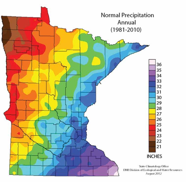
7 Property Information DESCRIPTION: TAX PID #: BUILDINGS: 72.43± Acres. N½ of NW¼ exc N4Cor W S SW133 SW SE66.81 NE NE E94.39 N to Beg Section 28, T107N-R28W (not to be used on legal documents) (Garden City Township, Blue Earth County, Minnesota) R None REAL ESTATE TAXES: 2018 Ag Hmstd taxes = $1, Special Assessments = $0 FSA INFORMATION: Total acres = ± acres FSA Tillable acres = ± acres Corn base acres = ± acres Corn PLC Yield = 165 ± bushels Farm Program Info - Enrolled into Agricultural Risk Coverage (ARC) County SOIL DESCRIPTION: Lasa, Fedji, Darfur, Litchfield, Grogan, Kingston. See Soils Map. CPI: Crop Productivity Index = 63.7 TOPOGRAPHY: DRAINAGE: Level to rolling Random tile. See Tile Map. NRCS CLASSIFICATIONS ON TILLABLE ACRES: Exempt from conservation compliance provisions. NHEL - Non-Highly Erodible Land WINGERT REALTY & LAND SERVICES, INC. stipulates that they are representing the seller exclusively in this transaction. The information gathered for this brochure in its entirety is from sources deemed reliable, but cannot be guaranteed by Seller, Wingert Realty & Land Services, Inc., or its staff. Package is subject to prior sale, price change, correction or withdrawal. The buyer must make their own independent investigation of the property. The buyer is purchasing the property as is.

8 Tile Map This tile map is an approximation. Wingert Realty & Land Services, Inc. does not guarantee tile maps, footage, tile condition, location, size, grade or depth. 24 Clay Tile = Tile = Intake


9 Soils Map State: Minnesota County: Blue Earth Location: N-28W Township: Garden City Acres: Date: 4/17/2018 Soils data provided by USDA and NRCS. Area Symbol: MN013, MN013, Soil Soil Area Area Version: Version: Code Soil Description Acres Percent of field PI Legend Non Irr Class *c Productivity Index Bromegrass alfalfa Bromegrass alfalfa hay Corn Oat s Soybeans 222B Lasa fine sand, 2 to 8 percent slopes % IIIs B Fedji loamy fine sand, 3 to 8 percent % IIIs slopes 281 Darfur loam % IIw Litchfield loamy fine sand, 1 to % IIIs percent slopes 128B Grogan silt loam, 3 to 6 percent % IIe slopes 197 Kingston silty clay loam, 1 to 3 percent slopes % Iw 100 Weighted Average *c: Using Capabilities Class Dominant Condition Aggregation Method Soils data provided by USDA and NRCS.
10 Soil Descriptions LASA SERIES - Soiol # 222B The Lasa series consists of very deep and deep, well drained soils formed in outwash or lacustrine sediments. They are on outwash plains, terraces, and lake plains. They have moderately rapid permeability. Slopes range from 0 to 35 percent. Mean annual precipitation is about 27 inches. Mean annual temperature is about 47 degrees F. TYPICAL PEDON: Lasa loamy fine sand with a 3 percent south-facing convex slope on a ground moraine with a mantle of deltaic sediments in a cultivated field. GEOGRAPHIC SETTING: These soils have plane to convex slopes with gradients of 0 to 35 percent. They are on lake plains, outwash plains, valley trains, and terraces. The soils formed in loamy fine sand or fine sand sediments that are stratified. Loamy glacial till or silty or finer lacustrine sediments commonly begins at depths ranging from 60 to 80 inches. These sediments are from the Des Moines lobe of the Late Wisconsinan glaciation. Mean annual temperature is 45 to 48 degrees F. Mean annual precipitation is 24 to 30 inches. Frost-free days range from 124 to 150. Elevation above sea level ranges from 700 to 1570 feet. GEOGRAPHICALLY ASSOCIATED SOILS: The main ones are the Dassel, Fieldon, and Litchfield soils which formed in sediments similar to those of the Lasa soils and are members of the same hydrosequence. The Dassel soils are poorly and very poorly drained and are commonly in swales and depressions. The poorly drained Fieldon soils have free carbonates throughout and are on lower lying terrain. The moderately well and somewhat poorly drained Litchfield soils are on lower lying or less sloping terrain. DRAINAGE AND PERMEABILITY: Well drained. Surface runoff is slow or rapid. Permeability is moderately rapid. FEDJI SERIES - Soil # 69B The Fedji series consists of deep well drained soils that formed in moderately thick sandy mantle of outwash and the underlying loamy glacial till or lacustrine sediments on glacial moraines and on the periphery of outwash plains, lake plains, and deltas. Permeability is rapid in the sandy mantle and moderate in the rest of the soil. Their slopes range from 1 to 18 percent. Mean annual air temperature is about 46 degrees F, and mean annual precipitation is about 27 inches. TYPICAL PEDON: Fedji loamy fine sand with a convex slope of 4 percent on a ground moraine in a cultivated field. GEOGRAPHIC SETTING: These soils have plane or convex slopes with gradients of 1 to 18 percent on glacial moraines and on the periphery of outwash plains, lake plains, and deltas. These soils formed in 20 to 40 inches of dominantly sandy sediments and loamy glacial till or lacustrine sediments. These sediments are from the Des Moines lobe of the Late Wisconsin glaciation. The climate is humid continental with warm summers and cold winters. Mean annual temperature is 45 to 48 degrees F, and mean annual precipitation is 24 to 30 inches. GEOGRAPHICALLY ASSOCIATED SOILS: The Clarion, Darfur, Fieldon, and Lasa soils are the main ones. The Darfur and Fieldon soils are poorly drained and are on surrounding flats and drainageways. The well drained Clarion soils and somewhat excessively drained Lasa soils are on terrain similar to that of the Fedji soils. DRAINAGE AND PERMEABILITY: Well drained. Surface runoff is slow to medium. Permeability is rapid in the upper sediment and moderate in the lower sediments.
11 Soil Descriptions DARFUR SERIES - Soil # 281 The Darfur series consists of deep, poorly drained soils formed in lacustrine and outwash sediments on glacial lake plains and outwash plains. The permeability is moderate or moderately rapid in the upper mantle and moderately rapid in the subsoil and substratum. Slopes range from 0 to 2 percent. Mean annual temperature is about 47 degrees F, and mean annual precipitation is 28 inches. TYPICAL PEDON: Darfur loam with a plane slope on a delta in a glacial lake plain in a cultivated field. GEOGRAPHIC SETTING: These soils have plane slopes with gradient of less than 2 percent. They commonly are on the deltaic portions of glacial lake plains and less commmonly on outwash plains. They formed in loamy and sandy lacustrine or outwash sediments that are dominated by fine and very fine sand and that commonly are stratified. Loamy glacial till or silty lacustrine sediments underlie these sediments at depths below 50 inches in some pedons. These sediments are of the Des Moines lobe of the Late Wisconsinan glaciation. Mean annual precipitation is 26 to 30 inches, and mean annual temperature is 45 to 48 degrees F. GEOGRAPHICALLY ASSOCIATED SOILS: These are the Dassel, Fieldon, and Grogan soils which formed in similar sediments and are members of a hydrosequence with Darfur soils. The very poorly drained Dassel soils are in depressions and swales. The poorly drained Fieldon soils have carbonates throughout and are on terrain that is similar to that of the Darfur soils. The moderately well drained Grogan soils are on slight rises. The moderately well and somewhat poorly drained sandy Litchfield soils and the somewhat excessively drained sandy Lasa soils are associated in some places. moderate or moderately rapid in the upper mantle and moderately rapid in the subsoil and underlying material. LITCHFIELD SERIES - Soil # 181 The Litchfield series consists of very deep, moderately well drained soils that formed in glacio-fluvial deposits on outwash plains, terraces, or deltas. Permeability is moderately rapid or rapid. Slopes range from 0 to 3 percent. Mean annual temperature is 48 degrees F. Mean annual precipitation is 28 inches. TYPICAL PEDON: Litchfield loamy fine sand in a bromegrass pasture. GEOGRAPHIC SETTING: These soils are on nearly level to gently sloping outwash plains, stream terraces or deltas. Slopes range from 0 to 3 percent. The soils formed mostly in sandy glacio-fluvial deposits that have finer textured layers. These materials generally range from 5 to 10 feet thick and overlie medium textured drift or lacustrine deposits and are late Wisconsinan in age. Mean annual precipitation is 26 to 30 inches. Mean annual temperature is 45 degrees to 50 degrees F. Frost free days range from 124 to 165. Elevations above sea level range from 700 to 1400 feet. GEOGRAPHICALLY ASSOCIATED SOILS: The most common associated soils are the Darfur, Dassel and Sparta soils. The poorly drained Darfur soils are on flats. The very poorly drained Dassel soils are in depressions. The excessively drained Sparta soils are on more sloping positions and/or are on higher lying terrain. DRAINAGE AND PERMEABILITY: Moderately well drained. Permeability is moderately rapid or rapid. Surface runoff is slow. DRAINAGE AND PERMEABILITY: Poorly drained. Surface runoff is slow. Permeability is
12 Soil Descriptions GROGAN SERIES - Soil # 128B The Grogan series consists of deep, well and moderately well drained soils that formed in calcareous silty lacustrine sediments on glacial lake plains. These soils have moderately rapid permeability. They have slopes with gradient of 0 to 15 percent. Mean annual precipitation is about 26 inches, and mean annual temperature is about 47 degrees F. TYPICAL PEDON: Grogan silt loam with a 3 percent convex east-facing slope on a delta in a glacial lake plain in a cultivated field. GEOGRAPHIC SETTING: These soils have plane or convex slopes with gradients of 0 to 15 percent primarily in deltaic portions of glacial lake plains. They formed in calcareous, silty lacustrine sediments of the Des Moines lobe of the Late Wisconsinan glaciation. Mean annual temperature is 45 to 48 degrees F, and mean annual precipitation if 24 to 30 inches. GEOGRAPHICALLY ASSOCIATED SOILS: The Grogan soils are the dominant soils in their area of occurrence. The poorly drained Darfur soils and the somewhat poorly drained Yahara soils are associated in a few places. These soils formed in somewhat similar sediments. DRAINAGE AND PERMEABILITY: Well or moderately well drained. Surface runoff is slow to medium. Permeability is moderately rapid. KINGSTON SERIES - Soil # 197 The Kingston series consists of deep moderately well and somewhat poorly drained soils that formed in deep silty calcareous glacial lacustrine sediments on glacial lake plains. These soils have moderate permeability. They have slopes of 0 to 3 percent. Mean annual precipitation is about 29 inches, and mean annual temperature is about 48 degrees F. TYPICAL PEDON: Kingston silty clay loam with a slightly convex slope of about 1 percent on a glacial lake plain in a cultivated field. GEOGRAPHIC SETTING: These soils have plane or slightly convex slopes on glacial lake plains. Slope gradients range from 0 to 3 percent. These soils formed in deep, calcareous, silty lacustrine sediments of Late Wisconsinan Age. The climate is midcontinental with warm summers and cold winters. Mean annual temperature is approximately 45 to 52 degrees F, and mean annual precipitation is approximately 26 to 31 inches. GEOGRAPHICALLY ASSOCIATED SOILS: The main ones are the Madelia and Truman soils which form a drainage sequence with the Kingston soils. The well drained Truman soils are on rolling slopes. The poorly drained Madelia soils are on nearly level slopes. DRAINAGE AND PERMEABILITY: Moderately well or somewhat poorly drained. Surface runoff is slow or medium. Permeability is moderate.
13
14
15 Thank You for the opportunity to present this property to you. We hope you found the information complete and the property of interest. However, if this property doesn t meet your needs, please let us know. We will do our best to find one which satisfies your requirements. Also, if you feel you have no interest in this property, please pass this package along to a friend or associate who might have an interest.
16 WINGERT REALTY & LAND SERVICES, INC. Serving Minnesota and Northern Iowa Mankato Office: Toll Free LAND (5263) Local LAND (5263) CHARLES WINGERT, ALC PAST NATIONAL PRESIDENT OF REALTORS LAND INSTITUTE (2013) Broker Direct Line: DARRELL HYLEN, ALC Real Estate Sales & Lease Negotiation Direct Line: Auctioneer # Auctioneer # DAVID HANSON Real Estate Sales Direct Line: David@WingertRealty.com Auctioneer # Redwood Falls Office: RICHARD HAUGE, ALC & ARA Real Estate Sales & Appraisals Direct Line: Rick@WingertRealty.com Auctioneer # ALL ARE LICENSED MN REALTORS THE LAND REPORT, the magazine of the American Landowner, has named Wingert Realty & Land Services, Inc. America s Best Brokerages and Top Auction Houses in the U.S.A.! 5/9
For Sale at: $136,000.00
 We are pleased to present Rachey Hunting & Rec 80 ± Acres Medo Township, Blue Earth County SUBJECT PROPERTY For Sale at: $136,000.00 Listing Agent:Charles Wingert Office: 507-345-LAND (5263) Toll Free:
We are pleased to present Spence Farms 145 ± Acres Pleasant Mound Township, Blue Earth County
 We are pleased to present Spence Farms 145 ± Acres Pleasant Mound Township, Blue Earth County PARCEL 1 Minimum maintenance Township road PARCEL 2 PARCEL 3 = PARCELS 1+2 This property to be sold by Sealed
For Sale at $425,000.00
 We are pleased to present Spence Farms 65 ± Acres Pleasant Mound Township, Blue Earth Minimum maintenance Township road SUBJECT PROPERTY For Sale at $425,000.00 Listing Agent: Charles Wingert, ALC Office:
We are pleased to present Floyd C. and Lovina M. Borghorst Trust ± Acres Eureka Township, Dakota County
 We are pleased to present Floyd C. and Lovina M. Borghorst Trust 315.05 ± Acres Eureka Township, Dakota County PARCEL 2 PARCEL 1 PARCEL 3 = PARCELS 1+2 This property to be sold by Sealed Bid Auction Owner:
BROWN COUNTY FARMLAND AUCTION
 BROWN COUNTY FARMLAND AUCTION CROP - PASTURE - HUNTING - INVESTMENT 62 Acres +/- TUESDAY, NOVEMBER, 1 :30am Auction Location: The DEC (Dakota Event Center) - Lamont St. - Aberdeen, SD 5401 Mercier & Ravina
² 2015 Program Year. Farm Tract McLeod County, Minnesota 1:4, NHEL NHEL
 United States Department of Agriculture McLeod County, Minnesota Farm 5125 #* 2 3.65 NHEL Tract 2762 1 33.19 NHEL ² 2015 Program Year Map Created November 06, 2014 Common Land Unit Cropland Non-cropland
Maggie Payne Jim Turenne
 Maggie Payne Jim Turenne USDA-NRCS 60 Quaker Lane, Suite 46 Warwick, RI. 02886 401-822-8832 maggie.payne@ri.usda.gov U.S. Department of Agriculture 1935: Soil Conservation Service (SCS) Natural Resources
MILLS COUNTY, IOWA FARMLAND FOR SALE PRICE REDUCED
 MILLS COUNTY, IOWA FARMLAND FOR SALE PRICE REDUCED Owners: Riverdale Farm Corp. Acres: 302.59 Legal Description: Location: Description: See Attached From I-29/Highway 370 exit, 1 ¾ Miles west on Highway
3.3 CLIMATE, GEOLOGY, TOPOGRAPHY, AND SOILS CLIMATE GEOLOGY TOPOGRAPHY
 3.3 CLIMATE, GEOLOGY, TOPOGRAPHY, AND SOILS This section describes the climate, geology, topography, and soil resource characteristics of the Yolo Bypass Wildlife Area (Wildlife Area). Agricultural soil
Custom Soil Resource Report for Forrest County, Mississippi
 United States Department of Agriculture Natural Resources Conservation Service A product of the National Cooperative Soil Survey, a joint effort of the United States Department of Agriculture and other
Soil Map Polk County, Florida
 Soil Map Polk County, Florida 28 9' 21'' 28 8' 23'' 3113000 3113200 3113400 3113600 3113800 3114000 3114200 3114400 3114600 81 51' 19'' 81 51' 19'' 416000 416000 ± 416200 416200 68 416400 68 416400 7 13
160 Acres of Tillable Land, Alfalfa, Pasture, Building Site, and Rec Area in Sun Prairie Township! Thursday, November 1, 2018 at NOON
 160+/- Acres of McCook County land 160 Acres of Tillable Land, Alfalfa, Pasture, Building Site, and Rec Area in Sun Prairie Township! Thursday, November 1, 2018 at NOON Located from Salem, SD on US HWY
Chapter 2. Regional Landscapes and the Hydrologic Cycle
 Chapter 2. Regional Landscapes and the Hydrologic Cycle W. Lee Daniels Department of Crop and Soil Environmental Sciences, Virginia Tech Table of Contents Introduction... 23 Soils and landscapes of the
Soil Map Boulder County Area, Colorado (Planet Blue Grass) Web Soil Survey National Cooperative Soil Survey
 Web Soil Survey National Cooperative Soil Survey") 475910 476000 476090 476180 476270 476360 105 16' 21'' W 476450 476540 476630 476720 476810 4453350 4453440 4453260 4453350 4453170 4453260 4453080 4453170 4453080 475820 475910 4452990 476000 476090 476180
475910 476000 476090 476180 476270 476360 105 16' 21'' W 476450 476540 476630 476720 476810 4453350 4453440 4453260 4453350 4453170 4453260 4453080 4453170 4453080 475820 475910 4452990 476000 476090 476180
Near Sledge, Mississippi. Please call to arrange a private viewing
 $3,958,000.00 $1,685,000 ($4,010/Acre) ($3,539/Acre) Precision Leveled Cropland 936.7 Total Acres - 598.39 Cropland Acres - 32.54 CRP Acres - 252.7 Timberland Acres (5) Irrigation Wells CRP Income: $6,500
RALPH SIMMONS STATE FOREST 2016 LAND MANAGEMENT PLAN EXHIBITS
 RALPH SIMMONS STATE FOREST 2016 LAND MANAGEMENT PLAN EXHIBITS EXHIBIT A Location Map Exhibit A EXHIBIT B Management Accomplishment Summary for RSSF EXHIBIT C Proximity to Other Public Lands Exhibit C
Total Acres: Tillable Acres: Irrigated Acres: All Improvements will be managed by Farmers National Company / CHS.
 GROUP P Parcel # Acres Twp County FSA Farm FSA Tract Tillable Acres Irrigated Acres 14-040-011-022-00 105.00 Lagrange Cass 7797 7858 262.12 72.50 14-040-011-022-10 5.00 Lagrange Cass 7797 7858 w 040-011-022-00
Producing Chandler Walnut Orchard
 AG-LAND Investment Brokers 275 Sale Lane Red Bluff, CA 96080 530-529-4400 Fax 530-527-5042 Producing Chandler Walnut Orchard West Sacramento Avenue - Chico, CA AG-LAND INVESTMENT BROKERS 275 Sale Lane
CALIFORNIA AGRICULTURAL PR OPERTIES, IN C. BOWLSBEY 320 LIBERTY ISLAND ROAD BUYER: RASSMUSSEN TRUST
 CALIFORNIA AGRICULTURAL PR OPERTIES, IN C. BOWLSBEY 320 LIBERTY ISLAND ROAD SELLER: BOWLSBEY TRUST BUYER: RASSMUSSEN TRUST LOCATION: The Bowlsbey 320 is located ten (10) miles southeast of the City of
Jim Turenne. Soils on Social Media
 Jim Turenne USDA-NRCS 60 Quaker Lane, Suite 46 Warwick, RI. 02886 401-822-8832 Jim.turenne@ri.usda.gov Soils on Social Media www.twitter.com/soilsne www.fb.com/soilsne www.nesoil.com U.S. Department of
Carrick Road $798,000
 1955-2020 Carrick Road 165.76± acres Fayette/Scott Counties $798,000 Offered Exclusively By: Zach Davis Principal Broker +1.859.576.8195 www.kirkfarms.com zach@kirkfarms.com Measuring an appx. 165+/- acres,
Cripps Ranch 76+/- Acres Orchard Development Opportunity Dixon, CA. Presented By:
 Cripps Ranch 76+/- Acres Orchard Development Opportunity Dixon, CA Presented By: Cripps Ranch 76+/- Acres Orchard Development Opportunity Dixon, CA Location: This property is located at 5663 Dally Road
KANSAS GEOLOGICAL SURVEY Open File Report LAND SUBSIDENCE KIOWA COUNTY, KANSAS. May 2, 2007
 KANSAS GEOLOGICAL SURVEY Open File Report 2007-22 LAND SUBSIDENCE KIOWA COUNTY, KANSAS Prepared by Michael T. Dealy L.G., Manager, Wichita Operations SITE LOCATION The site was approximately four miles
Geology and New England Landscapes
 Geology and New England Landscapes Jim Turenne, CPSS USDA-NRCS Warwick, RI. http://nesoil.com Why Geology? Provides the big picture of site conditions. Major part of soil formation (parent material and
YELLOW MEDICINE COUNTY FARMS FOR SALE
 YELLOW MEDICINE COUNTY FARMS FOR SALE Owners Rhea Trusts 790+ acres of high quality cropland in western Yellow Medicine County, MN. The land has been owned by the Rhea family for many years. The land includes
Description DESCRIPTION
 DESCRIPTION The location of the Upper James Watershed is located in northeastern South Dakota as well as southeastern North Dakota. It includes the following counties located in North Dakota Barnes, Dickey,
Soil Surveys. What are the most important properties to consider in a taxonomic system used for making a soil survey?
 Soil Surveys What are the most important properties to consider in a taxonomic system used for making a soil survey? What is a Soil Survey? Inventory of soil resources Delineation of spatial distribution
On-Site Soils Investigation. Buttermilk Way Storm water Treatment Project Buzzards Bay. MA. February 28 th, 2012
 1 On-Site Soils Investigation Buttermilk Way Storm water Treatment Project Buzzards Bay. MA February 28 th, 2012 Glenn Stanisewski, Resource Soil Scientist, USDA-NRCS, West Wareham, MA Introduction: The
CALIFORNIA AGRICULTURAL PR OPERTIES, IN C. GALE RANCH
 CALIFORNIA AGRICULTURAL PR OPERTIES, IN C. GALE RANCH LOCATION: The Ranch is located 6 Yi miles west of the City of Davis on the northwest corner of County Roads 29A and 92E in Yolo County. SIZE: 368.64
Soil Formation. Lesson Plan: NRES B2-4
 Soil Formation Lesson Plan: NRES B2-4 1 Anticipated Problems 1. What are five different factors that affect soil formation? 2. What are some different types of parent material that affect soils? 3. What
Custom Soil Resource Report Soil Map
 77 35' 22'' W Custom Soil Resource Report Soil Map 77 35' 0'' W 282170 282220 282270 282320 282370 282420 282470 282520 282570 282620 40 59' 2'' N 40 58' 52'' N 4539900 4539950 4540000 4540050 4540100
Appendix 2b. NRCS Soil Survey
 Appendix 2b NRCS Soil Survey 118 19' 25'' W Nonirrigated Capability Class Antelope Valley Area, California (Del Sur Solar Site) 118 17' 28'' W 378900 379200 379500 379800 380100 380400 380700 381000 381300
Soil Morphology and Stratigraphy on an Erosional Footslope: Dickinson Experiment Station in Western North Dakota
 Soil Morphology and Stratigraphy on an Erosional Footslope: Dickinson Experiment Station in Western North Dakota By D. Claypool, D. G. Hopkins, and J. L. Richardson ABSTRACT A first order soil survey of
Custom Soil Resource Report for St. Lucie County, Florida
 United States Department of Agriculture Natural Resources Conservation Service A product of the National Cooperative Soil Survey, a joint effort of the United States Department of Agriculture and other
The Soils and Land Capability for Agriculture. Land North of Aberdeen, Aberdeenshire
 The Soils and Land Capability for Agriculture Of Land North of Aberdeen, Aberdeenshire Report prepared for Peter Radmall Associates May 2012 Reading Agricultural Consultants Ltd Beechwood Court, Long Toll,
Water Quality and Water Quantity: Two sides of the Same Coin. Chris Jones
 Water Quality and Water Quantity: Two sides of the Same Coin Chris Jones Unit of the College of Engineering Director: Larry Weber 90 Graduate Students from 16 countries 61 Research Engineers and Scientists
Standards and Procedures for Site Specific Soil Mapping in Rhode Island. Pg 1
 Standards and Procedures for Site Specific Soil Mapping in Rhode Island Pg 1 The Task Take This and Create This The Task Take This and Create This and a Report Pg 2 How is this different than the RI Soil
4. Soils and soil conditions
 4. Soils and soil conditions 4.1 General characteristics 4.1.1 Soil-forming processes Most soils of the Bardenas area show no distinct characteristics of soil development. Except in the ancient alluvium
Custom Soil Resource Report Soil Map
 121 3' 56'' W Custom Soil Resource Report Soil Map 121 2' 49'' W 45 16' 39'' N 5013800 5014000 5014200 5014400 5014600 5014800 5015000 5015200 5015400 5015600 651800 652000 652200 652400 652600 652800
Custom Soil Resource Report for Polk County, Oregon
 United States Department of Agriculture Natural Resources Conservation Service A product of the National Cooperative Soil Survey, a joint effort of the United States Department of Agriculture and other
Custom Soil Resource Report for Clackamas County Area, Oregon, and Marion County Area, Oregon
 United States Department of Agriculture Natural Resources Conservation Service A product of the National Cooperative Soil Survey, a joint effort of the United States Department of Agriculture and other
1. Any process that causes rock to crack or break into pieces is called physical weathering. Initial product = final product
 Weathering 1. Any process that causes rock to crack or break into pieces is called physical weathering. Initial product = final product End Result of physical weathering is increased surface area. 2. Physical
Aerial Map. map center: 43 24' 27.29, ' ft 1886ft 3773ft. 9-99N-72W Gregory County South Dakota
 Aerial Map map center: 43 24' 27.29, -99 21' 57.12 0ft 1886ft 3773ft 9-99N-72W Gregory County South Dakota 1/23/2019 338 Ave 339 Ave 340 Ave 341 Ave 342 Ave 343 Ave 344 Ave LANDING CREEK TOWNSHIP T 99
105 (+/-) acres Jefferson County, Arkansas
 acres Jefferson County, Arkansas") offered for sale THE PB 105 A recreational and agricultural investment opportunity. 105 (+/-) acres Jefferson County, Arkansas offered by Licensed in Arkansas, Louisiana, Mississippi, Tennessee and Texas
offered for sale THE PB 105 A recreational and agricultural investment opportunity. 105 (+/-) acres Jefferson County, Arkansas offered by Licensed in Arkansas, Louisiana, Mississippi, Tennessee and Texas
Science EOG Review: Landforms
 Mathematician Science EOG Review: Landforms Vocabulary Definition Term canyon deep, large, V- shaped valley formed by a river over millions of years of erosion; sometimes called gorges (example: Linville
Custom Soil Resource Report for Okeechobee County, Florida
 United States Department of Agriculture Natural Resources Conservation Service A product of the National Cooperative Soil Survey, a joint effort of the United States Department of Agriculture and other
The future of the Lowland Belizean Savannas?.
 The future of the Lowland Belizean Savannas?. Using cluster analysis to explore multivariate spatial patterns in savanna soils PETER FURLEY & SARAH BEADLE UK Belize association 15 th November 2014 Outline
Custom Soil Resource Report for Wright County, Minnesota
 United States Department of Agriculture Natural Resources Conservation Service A product of the National Cooperative Soil Survey, a joint effort of the United States Department of Agriculture and other
For Sale - 56 Acre Sandstone Quarry State Route 511, Oberlin/Kipton, OH 44075
 14647 State Route 511, Oberlin/Kipton, OH 44075 56 ACRES Vermilion Rd Gifford Rd Haigh Rd 44 Summary The Kipton sandstone quarry is included in 56 acre tract owned by Terry A. Johnson, of Huron, Ohio.
Custom Soil Resource Report for Southampton County, Virginia
 United States Department of Agriculture Natural Resources Conservation Service A product of the National Cooperative Soil Survey, a joint effort of the United States Department of Agriculture and other
Custom Soil Resource Report for Columbus County, North Carolina
 United States Department of Agriculture Natural Resources Conservation Service A product of the National Cooperative Soil Survey, a joint effort of the United States Department of Agriculture and other
The Geology of Sebago Lake State Park
 Maine Geologic Facts and Localities September, 2002 43 55 17.46 N, 70 34 13.07 W Text by Robert Johnston, Department of Agriculture, Conservation & Forestry 1 Map by Robert Johnston Introduction Sebago
Surficial Geology of Antioch Quadrangle
 Illinois Preliminary Geologic Map IPGM Antioch-SG Surficial Geology of Antioch Quadrangle Lake County, Illinois and Kenosha County, Wisconsin Andrew J. Stumpf and Michael L. Barnhardt 2005 Department of
CRP HEL CRP Ortho Imagery. Tract Cropland Total: acres
 United States Department of Agriculture Madison County, Iowa 17 4.09 23 1.26 6 10.74 14 2.89 12 1.7 1 18.02 230TH LN T 347 3 34 4.65 13 2.81 2 11.4 ELMWOOD AVE 16 3 6.49 18 6.5 1.59 21 2.35 8.76 24 11
Cherry County, Nebraska
 Cherry County, Nebraska Co-Listed with Maddux Landbanc Realty, LLC Offered Exclusively By: NORTH PLATTE OFFICE P.O. Box 1166 I-80 & US Hwy 83 North Platte, NE 69103 www.agriaffiliates.com (308) 534-9240
STUDY GUIDE FOR CONTENT MASTERY. Surface Water Movement
 Surface Water SECTION 9.1 Surface Water Movement In your textbook, read about surface water and the way in which it moves sediment. Complete each statement. 1. An excessive amount of water flowing downslope
Web Soil Survey National Cooperative Soil Survey
 122 14' 27'' W () 122 13' 37'' W 40 8' 40'' N 564700 564800 564900 565000 565100 565200 565300 565400 565500 565600 565700 565800 40 8' 40'' N 4443400 4443500 4443600 4443700 4443800 4443900 4444000 4443400
Chapter 2. Wearing Down Landforms: Rivers and Ice. Physical Weathering
 Chapter 2 Wearing Down Landforms: Rivers and Ice Physical Weathering Weathering vs. Erosion Weathering is the breakdown of rock and minerals. Erosion is a two fold process that starts with 1) breakdown
 United States Department of Agriculture Natural Resources Conservation Service A product of the National Cooperative Soil Survey, a joint effort of the United States Department of Agriculture and other
Custom Soil Resource Report for Livingston Parish, Louisiana
 United States Department of Agriculture Natural Resources Conservation Service A product of the National Cooperative Soil Survey, a joint effort of the United States Department of Agriculture and other
Custom Soil Resource Report for Gillespie County, Texas
 United States Department of Agriculture Natural Resources Conservation Service A product of the National Cooperative Soil Survey, a joint effort of the United States Department of Agriculture and other
What is Williams Soil?
 Williams Series North Dakota State Soil Soil Science Society of America Introduction Many states have a designated state bird, flower, fish, tree, rock, etc. And, many states also have a state soil one
Chittenden Road Prune Orchard Corning, California
 AG-LAND INVESTMENT BROKERS 275 Sale Lane / P. O. Box 896 Red Bluff, CA 96080 530.529.4400 office / 530.527.5042 fax Chittenden Road Prune Orchard Corning, California Property: 40.00 acres planted to producing
Saline and Sodic Soils: Characteristics and Properties
 Saline and Sodic Soils: Characteristics and Properties DOUGLAS D. MALO, PRESENTING TODAY DAVID E. CLAY, CHERYL L. REESE, SHARON A. CLAY RACHEL OWEN, TULSI KHAREL, GIRMA BIRRU, JOHN GREEN,* TOM M. DESUTTER
Custom Soil Resource Report for Clackamas County Area, Oregon
 United States Department of Agriculture Natural Resources Conservation Service A product of the National Cooperative Soil Survey, a joint effort of the United States Department of Agriculture and other
Laboratory Exercise #4 Geologic Surface Processes in Dry Lands
 Page - 1 Laboratory Exercise #4 Geologic Surface Processes in Dry Lands Section A Overview of Lands with Dry Climates The definition of a dry climate is tied to an understanding of the hydrologic cycle
Soils of Rhode Island
 Soils of Rhode Island Jim Turenne, RI State Soil Scientist USDA-NRCS 60 Quaker Ln. Suite 46 Warwick, RI. 02886 401-822-8830 http://nesoil.com Jim.turenne@ri.usda.gov About NRCS Established as the Soil
Custom Soil Resource Report for Valley County, Montana
 United States Department of Agriculture Natural Resources Conservation Service A product of the National Cooperative Soil Survey, a joint effort of the United States Department of Agriculture and other
RANCHO de DOS PALMAS DAVIS, California, AC +/-
 RANCHO de DOS PALMAS DAVIS, California, 507.28 AC +/- Boundary Transmission Line Pond / Tank Well SCOTT STONE P: (530) 662-4094 sastone57@gmail.com 37874 County Road 28, Woodland, Ca. 95695 The information
Custom Soil Resource Report for Pinal County, Arizona, Western Part
 United States Department of Agriculture Natural Resources Conservation Service A product of the National Cooperative Soil Survey, a joint effort of the United States Department of Agriculture and other
Custom Soil Resource Report for Falls County, Texas
 United States Department of Agriculture Natural Resources Conservation Service A product of the National Cooperative Soil Survey, a joint effort of the United States Department of Agriculture and other
Soil Formation. Parent Material. Time. Climate
 Soil Formation Parent Material Time Climate Topography Biota Main Objectives 1. Gain a general understanding of soil formation processes 2. Understand the importance of mineral weathering in soil formation
Custom Soil Resource Report for Clackamas County Area, Oregon
 United States Department of Agriculture Natural Resources Conservation Service A product of the National Cooperative Soil Survey, a joint effort of the United States Department of Agriculture and other
Custom Soil Resource Report for Multnomah County Area, Oregon
 United States Department of Agriculture Natural Resources Conservation Service A product of the National Cooperative Soil Survey, a joint effort of the United States Department of Agriculture and other
Evidence for distribution and thickness of Athens Sub-episode and older sediments in Ottawa County, Michigan
 Evidence for distribution and thickness of Athens Sub-episode and older sediments in Ottawa County, Michigan Patrick M. Colgan Department of Geology Grand Valley State University With thanks to Al Kehew
Introduction to Soil Science and Wetlands Kids at Wilderness Camp
 Introduction to Soil Science and Wetlands Kids at Wilderness Camp Presented by: Mr. Brian Oram, PG, PASEO B.F. Environmental Consultants http://www.bfenvironmental.com and Keystone Clean Water Team http://www.pacleanwater.org
Custom Soil Resource Report for Island County, Washington
 United States Department of Agriculture Natural Resources Conservation Service A product of the National Cooperative Soil Survey, a joint effort of the United States Department of Agriculture and other
Soil Erosion Calculation using Remote Sensing and GIS in Río Grande de Arecibo Watershed, Puerto Rico
 Soil Erosion Calculation using Remote Sensing and GIS in Río Grande de Arecibo Watershed, Puerto Rico Alejandra M. Rojas González Department of Civil Engineering University of Puerto Rico at Mayaguez.
Cook Road Ridgeway, South Carolina
 For Sale or Ground Lease ±66.0 AC Industrial Land k Rd Coo Cook Road Ridgeway, South Carolina THE INFORMATION CONTAINED HEREIN HAS BEEN GIVEN TO US BY THE OWNER OF THE PROPERTY OR OTHER SOURCES WE DEEM
Betsy Stevenson and Allison Mohrs (Skagit County Planning and Development Services) Jenny Baker, The Nature Conservancy
 Jenny Baker, The Nature Conservancy") TC Fisher Slough Final Design and Permitting Subject: Well Review Memorandum To: From: Betsy Stevenson and Allison Mohrs (Skagit County Planning and Development Services) Jenny Baker, The ature Conservancy
TC Fisher Slough Final Design and Permitting Subject: Well Review Memorandum To: From: Betsy Stevenson and Allison Mohrs (Skagit County Planning and Development Services) Jenny Baker, The ature Conservancy
CRUM RANCH AREA MAP YOLO COUNTY, California, AC +/-
 CRUM RANCH AREA MAP YOLO COUNTY, California, 235.59 AC +/- Map data 2016 Google Imagery 2016, CAPCOG, DigitalGlobe, Texas Orthoimagery Program, U.S. Geological Survey, USDA Farm Service Agency Boundary
Custom Soil Resource Report for Gillespie County, Texas
 United States Department of Agriculture Natural Resources Conservation Service A product of the National Cooperative Soil Survey, a joint effort of the United States Department of Agriculture and other
Hydric Rating by Map Unit Harrison County, Mississippi 30 27' 27'' 30 26' 57''
 Hydric Rating by Map Unit Harrison County, Mississippi 30 27' 27'' 30 26' 57'' 3370400 3370500 3370600 3370700 3370800 3370900 3371000 3371100 3371200 89 2' 40'' 89 2' 41'' 303700 303700 303800 303800
Appendix 1. River/Stream Classification for the NTPE
 Appendix Page Appendix. River/Stream Classification for the NTPE A.. Aquatic Classification Framework One of the goals of the ecoregional planning process is to develop a strategy to protect ecosystems
Custom Soil Resource Report for Kern County, California, Southwest Part
 United States Department of Agriculture Natural Resources Conservation Service A product of the National Cooperative Soil Survey, a joint effort of the United States Department of Agriculture and other
,Baynes Lake. TO...?&.?...A 2...KO.?'!!&... Sr. *logical Engineer
 > i evernment OF BRITISH COLUMBIA a TO...?&.?...A 2....KO.?'!!&... Sr. *logical Engineer... Grou,,water. Section Hydrology Division Wat.er... In~.~s.tiga.ti.On.s..Branck.... 5 u BJECT...C;.roun.dw.ater...Snve
Sacramento River Farmland Anderson, California
 AG-LAND INVESTMENT BROKERS 275 Sale Lane / P. O. Box 896 Red Bluff, CA 96080 530.529.4400 office / 530.527.5042 fax Sacramento River Farmland Anderson, California Property: 45 +/- acres of farmland with
Fairfield Hill Road Winnsboro, South Carolina
 Fairfield Hill Road Winnsboro, South Carolina Tom Milliken +1 803 331 6999 tmilliken@naiavant.com Tombo Milliken +1 803 206 8384 tombo.milliken@naiavant.com THE INFORMATION CONTAINED HEREIN HAS BEEN GIVEN
Which map shows the stream drainage pattern that most likely formed on the surface of this volcano? A) B)
 B)") 1. When snow cover on the land melts, the water will most likely become surface runoff if the land surface is A) frozen B) porous C) grass covered D) unconsolidated gravel Base your answers to questions
1. When snow cover on the land melts, the water will most likely become surface runoff if the land surface is A) frozen B) porous C) grass covered D) unconsolidated gravel Base your answers to questions
Waterbury Dam Disturbance Mike Fitzgerald Devin Rowland
 Waterbury Dam Disturbance Mike Fitzgerald Devin Rowland Abstract The Waterbury Dam was completed in October 1938 as a method of flood control in the Winooski Valley. The construction began in April1935
Overview of fluvial and geotechnical processes for TMDL assessment
 Overview of fluvial and geotechnical processes for TMDL assessment Christian F Lenhart, Assistant Prof, MSU Research Assoc., U of M Biosystems Engineering Fluvial processes in a glaciated landscape Martin
FOR SALE. Features Rives Road Petersburg, Virginia Chris Jenkins
 FOR SALE 3513 Rives Road Petersburg, Virginia 23805 Chris Jenkins T 804-228-4928 E cjenkins@ commonwealthcommercial.com Bill Barnett T 804-433-1821 E bbarnett@ commonwealthcommercial.com Features 142±
Custom Soil Resource Report for Yates County, New York
 United States Department of Agriculture Natural Resources Conservation Service A product of the National Cooperative Soil Survey, a joint effort of the United States Department of Agriculture and other
Appendix I SOIL RATING CHART. (Storie soil Index Rating = factor A* factor B* factor C* factor X) FACTOR A- Rating on character of Physical Profile
 FACTOR A- Rating on character of Physical Profile") Appendix I SOIL RATING CHART (Storie soil Index Rating = factor A* factor B* factor C* factor X) FACTOR A- Rating on character of Physical Profile Sr. No Particulars Percentage I Soil on recent alluvial
Appendix I SOIL RATING CHART (Storie soil Index Rating = factor A* factor B* factor C* factor X) FACTOR A- Rating on character of Physical Profile Sr. No Particulars Percentage I Soil on recent alluvial
Custom Soil Resource Report for Clackamas County Area, Oregon
 United States Department of Agriculture Natural Resources Conservation Service A product of the National Cooperative Soil Survey, a joint effort of the United States Department of Agriculture and other
Appendix B. Technical Memoranda and Reports
 Cotton Belt Corridor Regional Rail Project Draft Environmental Impact Statement Appendix B Technical Memoranda and Reports Technical memoranda and reports were prepared as independent documents to support
MAFF Ministry of IfiriLE Agriculture Fisheries and Food
 MAFF Ministry of IfiriLE Agriculture Fisheries and Food STATEMENT OF PHYSICAL CHARACTERISTICS AND AGRICULTURAL LAND CLASSIFICATION UPSLAND, KIRKLINGTON NORTH YORKSHIRE EXTRACTION OF SAND AND GRAVEL MARCH
Hartmann Ranch. potential vineyard ground acres +/
 Hartmann Ranch potential vineyard ground 95.403 acres +/ Location: Description: Water: Improvements: Crop history This ranch is located on Jefferson Blvd just South of North Courtland Road a few miles
Web Soil Survey National Cooperative Soil Survey
 121 52' 18'' W Irrigated Capability Class Sutter County, California () 121 51' 49'' W 597600 597700 597800 597900 598000 598100 598200 39 6' 27'' N 39 6' 27'' N 39 5' 57'' N 4328400 4328500 4328600 4328700
TEXTURE ANALYSIS. Unknown 1 Unknown 2. Unknown 3 6O 6O O Z 14X 10Z X X 8Z
 Unknown 1 Unknown 2 TEXTURE ANALYSIS Unknown 3 O 2O 10Z X X 8Z O 2X O Z 14X X 2O 6O 6O Parent Material & some of Seattle s soils ESRM 311/SEFS 507 Week 3 SOILS = f(cl, r, o, p, t) Parent Materials 1) Sedentary