On-Site Soils Investigation. Buttermilk Way Storm water Treatment Project Buzzards Bay. MA. February 28 th, 2012
|
|
|
- August Pierce
- 5 years ago
- Views:
Transcription

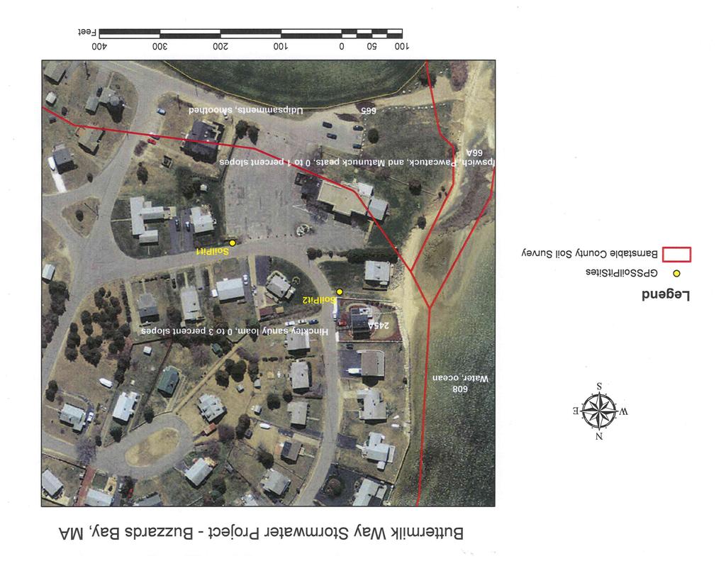
1 1 On-Site Soils Investigation Buttermilk Way Storm water Treatment Project Buzzards Bay. MA February 28 th, 2012 Glenn Stanisewski, Resource Soil Scientist, USDA-NRCS, West Wareham, MA Introduction: The purpose of this on-site visit was to evaluate the soil at two predetermined locations for the installation of a subsurface storm water treatment system at Taylor Point in the town of Buzzards Bay. Currently untreated storm water runoff is entering Onset Bay and Butler Cove resulting in the closing of shellfish beds. Participants: Bernie Taber Soil Conservationist, NRCS West Wareham Service Center, and Glenn Stanisewski Resource Soil Scientist, NRCS West Wareham Service Center. Evaluation: The investigation involved describing the soil profile at the two desired locations to a depth of 65 inches (Figure 1). The town of Buzzards Bay Public Works department excavated the soil pits to a depth of six feet using a backhoe (Figure 2). Figure 1: GPS locations of soil pits (yellow dots).

2 Figure 2: Soil pit #1 backhoe trench. 2
3 3 Results: Soil Pit #1 GPS Point 131 Sandy Fill material over a Carver loamy coarse sand natural soil Soil Survey Mapunit: 245A Hinckley sandy loam, 0 to 3 percent slopes Soil Parent Material: Glacial Till Glacial Outwash X Alluvium Eolian Outwash Lacustrine Fill X Organic Landform: Ridge Terrace X Esker Moraine Drumlin Depression Swale Drainageway Floodplain Dune Kame X Upland Slope Shape: Convex Concave Linear X Undulating Slope Gradient (%): 1 Elevation: 18 ft. GPS WP & Coordinates: WP131: N Lat W Long. Depth Horizon Color Texture Consistence Structure RMF s % Rock Frags. by Volume 0-9 ^A1 10YR 2/2 Very dark grayish Loamy sand Loose Weak fine & medium granular 9-14 ^A2 10YR 2/2 Very dark grayish ^Bw 10YR 4/4 Yellowish Loamy sand Coarse sandy loam Loose Very friable Weak fine granular Weak fine subangular blocky Ab 10YR 3/1 Very dark gray Eb 10YR 6/1 Gray Loamy coarse sand Coarse sand Loose Single grain Loose Single grain Bwb 7.5YR 4/4 Brown Sand Loose Single grain C1b 10YR 5/4 Yellowish C2b 10YR 5/4 Yellowish Sand Loose Single grain Gravelly sand Loose Single grain 15% gravel Additional Notes (% surface stones, rock outcrop, etc.): Standing water observed in the trench at 65 inches from the surface. There is approximately 1.5 ft. of sandy fill over a loamy coarse sand Carver soil type.
 separated by tees.")
4 Figure 3: Soil pit #1 profile showing ^A1, ^A2, ^Bw, Ab, Eb, and Bwb horizons (top to bottom) separated by tees. 4
5 5 Soil Pit #2 - GPS Point 132 Thin layer of fill material over a Hinckley loamy sand soil Soil Survey Mapunit: 245A Hinckley sandy loam, 0 to 3 percent slopes Soil Parent Material: Glacial Till Glacial Outwash X Alluvium Eolian Outwash Lacustrine Fill X Organic Landform: Ridge Terrace X Esker Moraine Drumlin Depression Swale Drainageway Floodplain Dune Kame X Upland Slope Shape: Convex Concave Linear X Undulating Slope Gradient (%): 0-1 Elevation: 18 ft. GPS WP & Coordinates: WP132: N Lat W Long. Depth Horizon Color Texture Consistence Structure RMF s % Rock Frags. by Volume 0 3 ^A 10YR 3/2 Loamy sand Loose Single grain Very dark grayish 3 5 ^M Black Impermeable Asphalt Rigid Massive 5 7 ^C 10YR 4/4 Yellowish 7 12 A 10YR 3/2 Very dark grayish AE 10YR 4/2 Dark Grayish Brown Bhs 7.5YR 4/4 Brown & 5 YR 3/4 Dark Reddish Brown C1 7.5YR 4/4 Brown C2 10YR 6/4 Light yellowish Gravelly sand (road base) Loose Single grain 15% fine gravel Loamy sand Loose Single grain 5% fine gravel Sand Loose Single grain 5% fine gravel Very Gravelly Sand Loose Single grain 35% gravel Very Gravelly Coarse Sand Loose Single grain 45% gravel Sand Loose Single grain 5% fine gravel Additional Notes (% surface stones, rock outcrop, etc.): Saturation observed in trench at 89 inches from surface. Bhs horizon had many, prominent, fine, medium, and coarse 5YR 3/4 masses of iron accumulation.
 separated by tees.")
6 Figure 6: Soil pit#2 profile showing ^A, ^M, ^C, A, AE, Bhs, C1 and C2 horizons (top to bottom) separated by tees. 6
 separated by tees. 7")
7 Figure 7: Close up of Soil Pit site #2 showing fill material (^A, ^M, ^C horizons) separated by tees. 7
8 8 Discussion: The soil described at Site #1 had between 1.5 feet and 2.0 feet of sandy fill material over a natural sandy glacial outwash soil known as Carver. The fill material is associated with the construction of the Massachusetts Maritime Academy s Capt. Charles Hurley library and parking lot which included a lot of land leveling in addition to the fill material (mapped as 665 Udipsamments, smoothed in the soil survey report). There were no indications of a seasonal high water table in soil pit #1 to a depth of 65 inches. Saturation was observed in the trench at a depth of 65 inches. Like the Carver soil, this soil is Excessively well drained with a Soil Hydrologic Group A designation. The soil described at Site #2 was on the town s Right of Way (Beach Way) which is a public access point to the bay and a small beach area. The soil profile had a very thin layer of fill material (seven inches thick) that is associated with the construction of a paved walk way leading down to the beach. In recent years adjoining private landowners had installed sod over the asphalt covering it up (Figure 7). There were no indications of a seasonal high water table in soil pit #2 to a depth of 65 inches. Saturation was observed in the trench at a depth of 89 inches. The natural soil profile had a subsurface Bhs horizon (at inches) that showed masses of iron accumulation consistent with spodic soil development. The natural soil profile fit the description of the Hinckley soil series that was identified on the soil survey map (mapunit 245A). Hinckley is an Excessively well drained sandy and gravelly glacial outwash soil with a Soil Hydrologic Group A designation. Summary and Conclusions: Based on this on-site investigation there were no indicators of a seasonal high water table within the upper five feet for either soil pit sites. There appears to be no water table limitations for the installation of a subsurface storm water treatment system. Additional Attachments 1. Soil Pit Location Map 2. Copies of original soil data sheets
9
10
11
Soil Surveys. What are the most important properties to consider in a taxonomic system used for making a soil survey?
 Soil Surveys What are the most important properties to consider in a taxonomic system used for making a soil survey? What is a Soil Survey? Inventory of soil resources Delineation of spatial distribution
Geology and New England Landscapes
 Geology and New England Landscapes Jim Turenne, CPSS USDA-NRCS Warwick, RI. http://nesoil.com Why Geology? Provides the big picture of site conditions. Major part of soil formation (parent material and
Maggie Payne Jim Turenne
 Maggie Payne Jim Turenne USDA-NRCS 60 Quaker Lane, Suite 46 Warwick, RI. 02886 401-822-8832 maggie.payne@ri.usda.gov U.S. Department of Agriculture 1935: Soil Conservation Service (SCS) Natural Resources
Parent Materials. & some of Seattle s soils
 Parent Material & some of Seattle s soils ESRM 311/SEFS 507 Week 3 SOILS = f(cl, r, o, p, t) Parent Materials 1) Sedentary a) residual (bedrock weathered in place) b) organic 2) Transported by a) gravity
Jim Turenne. Soils on Social Media
 Jim Turenne USDA-NRCS 60 Quaker Lane, Suite 46 Warwick, RI. 02886 401-822-8832 Jim.turenne@ri.usda.gov Soils on Social Media www.twitter.com/soilsne www.fb.com/soilsne www.nesoil.com U.S. Department of
Custom Soil Resource Report for Forrest County, Mississippi
 United States Department of Agriculture Natural Resources Conservation Service A product of the National Cooperative Soil Survey, a joint effort of the United States Department of Agriculture and other
TEXTURE ANALYSIS. Unknown 1 Unknown 2. Unknown 3 6O 6O O Z 14X 10Z X X 8Z
 Unknown 1 Unknown 2 TEXTURE ANALYSIS Unknown 3 O 2O 10Z X X 8Z O 2X O Z 14X X 2O 6O 6O Parent Material & some of Seattle s soils ESRM 311/SEFS 507 Week 3 SOILS = f(cl, r, o, p, t) Parent Materials 1) Sedentary
Soils of Rhode Island
 Soils of Rhode Island Jim Turenne, RI State Soil Scientist USDA-NRCS 60 Quaker Ln. Suite 46 Warwick, RI. 02886 401-822-8830 http://nesoil.com Jim.turenne@ri.usda.gov About NRCS Established as the Soil
Soils of the GLBRC Marginal Land Experiment (MLE) Sites
 Sites") KBS LTER Special Publication Soils of the GLBR Marginal Land Experiment (MLE) Sites. S. Kasmerchak and R. Schaetzl Department of Geography, Environmental, and Spatial Sciences Michigan State University
KBS LTER Special Publication Soils of the GLBR Marginal Land Experiment (MLE) Sites. S. Kasmerchak and R. Schaetzl Department of Geography, Environmental, and Spatial Sciences Michigan State University
Standards and Procedures for Site Specific Soil Mapping in Rhode Island. Pg 1
 Standards and Procedures for Site Specific Soil Mapping in Rhode Island Pg 1 The Task Take This and Create This The Task Take This and Create This and a Report Pg 2 How is this different than the RI Soil
Soil Map Boulder County Area, Colorado (Planet Blue Grass) Web Soil Survey National Cooperative Soil Survey
 Web Soil Survey National Cooperative Soil Survey") 475910 476000 476090 476180 476270 476360 105 16' 21'' W 476450 476540 476630 476720 476810 4453350 4453440 4453260 4453350 4453170 4453260 4453080 4453170 4453080 475820 475910 4452990 476000 476090 476180
475910 476000 476090 476180 476270 476360 105 16' 21'' W 476450 476540 476630 476720 476810 4453350 4453440 4453260 4453350 4453170 4453260 4453080 4453170 4453080 475820 475910 4452990 476000 476090 476180
Lowest and Youngest Terrace : Soil Pit #4
 Lowest and Youngest Terrace : Soil Pit #4 Observations : Where : Huntington Terraces Climate : Cloudy, mid 60 s Our soil pit was the lowest of the 4 sites The pit site was located on the right side of
Soil Map Polk County, Florida
 Soil Map Polk County, Florida 28 9' 21'' 28 8' 23'' 3113000 3113200 3113400 3113600 3113800 3114000 3114200 3114400 3114600 81 51' 19'' 81 51' 19'' 416000 416000 ± 416200 416200 68 416400 68 416400 7 13
12- TOL MLRA Soil Survey Area Approximately 15,000,000 Acres
 !@ 12- TOL MLRA Soil Survey Area Approximately 15,000,000 Acres Office Location: Tolland, Connecticut Staff: Donald Parizek Acting Soil Survey Office Party Leader Jacob Isleib Soil Scientist Marissa Theve
Monitoring and modelling hydrological fluxes in support of nutrient cycling studies in Amazonian rain forest ecosystems Tobon-Marin, C.
 UvA-DARE (Digital Academic Repository) Monitoring and modelling hydrological fluxes in support of nutrient cycling studies in Amazonian rain forest ecosystems Tobon-Marin, C. Link to publication Citation
HEBER D. LESSIG U.S. Soil Conservation Service, Box 248, Lisbon, Ohio
 THE SOILS DEVELOPED ON WISCONSIN AND ILLINOIAN- AGE GLACIAL OUTWASH TERRACES ALONG LITTLE BEAVER CREEK AND THE ADJOINING UPPER OHIO VALLEY, COLUMBIANA COUNTY, OHIO HEBER D. LESSIG U.S. Soil Conservation
 UNIT DESCRIPTIONS: Artificial Fill, Undocumented (Afu): Locally derived sandy silt and silty sand, locally with clay and varying amounts of gravel and man-made debris. Abundant concrete rubble, in places
MINERALOGICAL ALTERATIONS OF SOIL IRRIGATED WITH ACIDIC MINE WATER IN THE ALAMOSA RIVER BASIN
 MINERALOGICAL ALTERATIONS OF SOIL IRRIGATED WITH ACIDIC MINE WATER IN THE ALAMOSA RIVER BASIN by Stephanie J. Connolly Steve W. Blecker Grant E. Cardon Eugene Kelly Colorado State University, Department
Introduction to Soil Science and Wetlands Kids at Wilderness Camp
 Introduction to Soil Science and Wetlands Kids at Wilderness Camp Presented by: Mr. Brian Oram, PG, PASEO B.F. Environmental Consultants http://www.bfenvironmental.com and Keystone Clean Water Team http://www.pacleanwater.org
HYDRIC SOILS. Background
 Background HYDRIC SOILS Soils consist of natural bodies that occur on a landform within a landscape and have properties that result from the integrated effects of climate and living organisms, acting on
MAFF Ministry of IfiriLE Agriculture Fisheries and Food
 MAFF Ministry of IfiriLE Agriculture Fisheries and Food STATEMENT OF PHYSICAL CHARACTERISTICS AND AGRICULTURAL LAND CLASSIFICATION UPSLAND, KIRKLINGTON NORTH YORKSHIRE EXTRACTION OF SAND AND GRAVEL MARCH
NDWRCDP Disclaimer This work was supported by the National Decentralized Water Resources Capacity Development Project (NDWRCDP) with funding provided
 with funding provided") Glacial Landforms NDWRCDP Disclaimer This work was supported by the National Decentralized Water Resources Capacity Development Project (NDWRCDP) with funding provided by the U.S. Environmental Protection
Glacial Landforms NDWRCDP Disclaimer This work was supported by the National Decentralized Water Resources Capacity Development Project (NDWRCDP) with funding provided by the U.S. Environmental Protection
RALPH SIMMONS STATE FOREST 2016 LAND MANAGEMENT PLAN EXHIBITS
 RALPH SIMMONS STATE FOREST 2016 LAND MANAGEMENT PLAN EXHIBITS EXHIBIT A Location Map Exhibit A EXHIBIT B Management Accomplishment Summary for RSSF EXHIBIT C Proximity to Other Public Lands Exhibit C
2017 NACTA Contest FAQs for 2-Year and 4-Year Universities
 2017 NACTA Contest FAQs for 2-Year and 4-Year Universities 1. Have you determined how many practice days there will be? a. We plan on having 10 practice sites. They will be open on Tuesday, Wednesday,
BURIED SOILS OF GLOBE HILL, UPPER OHIO VALLEY
 BURIED SOILS OF GLOBE HILL, UPPER OHIO VALLEY HEBER D. LESSIG Soil Scientist, Box 248, Lisbon, Ohio A terrace, 5 mi downstream from Wellsville, Ohio, standing about 200 ft above the Ohio River, was recently
SOIL PROFILE STUDY GUIDE
 2017 USDA, Natural Resources Conservation Service Yuri Plowden Ecological Site Specialist SOIL PROFILE STUDY GUIDE The purpose of this study guide is to help familiarize you with different characteristics
6W9}* Appendix 2 to report No. P62 SOIL RESOURCES MAP OF TH E MPEKETONIAREA (LAMU AND TANA RIVER DISTRICTS) 40" 40 E LEGEND ISWC U8RAWY _& Jl W*g*n)ng
 40 40 E LEGEND ISWC U8RAWY _& Jl W*g*n)ng") 6W9}* Appendix 2 to report No. P62 SOIL RESOURCES MAP OF TH E MPEKETONIAREA (LAMU AND TANA RIVER DISTRICTS) 40" 40 E LEGEND ISWC U8RAWY _& Jl W*g*n)ng«ft, Tlw 9MtWt&nât COASTAL PLAINS (slopes less than
6W9}* Appendix 2 to report No. P62 SOIL RESOURCES MAP OF TH E MPEKETONIAREA (LAMU AND TANA RIVER DISTRICTS) 40" 40 E LEGEND ISWC U8RAWY _& Jl W*g*n)ng«ft, Tlw 9MtWt&nât COASTAL PLAINS (slopes less than
Geology of the Black River and Paw Paw River Watersheds. Dr. Tara Kneeshaw Grand Valley State University Department of Geology
 Geology of the Black River and Paw Paw River Watersheds Dr. Tara Kneeshaw Grand Valley State University Department of Geology Two Rivers Coalition September 11, 2013 There s nothing boring about Michigan
NACTA 2013 Soils Judging-2 Year Division
 Department of Animal and Food Sciences NACTA 2013 Soils Judging-2 Year Division Date: April 5, 2013 Contact: Dr. Richard Zartman richard.zartman@ttu.edu Rules: 1.Each team will consist of four (4) members
Soil Formation. Parent Material. Time. Climate
 Soil Formation Parent Material Time Climate Topography Biota Main Objectives 1. Gain a general understanding of soil formation processes 2. Understand the importance of mineral weathering in soil formation
Custom Soil Resource Report Soil Map
 121 3' 56'' W Custom Soil Resource Report Soil Map 121 2' 49'' W 45 16' 39'' N 5013800 5014000 5014200 5014400 5014600 5014800 5015000 5015200 5015400 5015600 651800 652000 652200 652400 652600 652800
Michigan s Geology and Groundwater
 Michigan s Geology and Groundwater Ralph J. Haefner Deputy Director U.S. Geological Survey Michigan-Ohio Water Science Center Lansing, Michigan Outline About the USGS Geology 101 Michigan s geology Bedrock
For Sale at $437,500.00
 We are pleased to present Carlson Farm 72.43 ± Acres Garden City Township, Blue Earth County For Sale at $437,500.00 Listing Agent: Darrell Hylen, ALC Office: 507-345-LAND (5263) Toll Free: 800-730-LAND
Custom Soil Resource Report for St. Lucie County, Florida
 United States Department of Agriculture Natural Resources Conservation Service A product of the National Cooperative Soil Survey, a joint effort of the United States Department of Agriculture and other
Soil Profiles (West, Ch. 8)
") Geology 229 Engineering Geology Lecture 24 Soil Profiles (West, Ch. 8) We have just finished the discussion of rock weathering. One direct consequence of weathering is the formation of the soil profile.
Geology 229 Engineering Geology Lecture 24 Soil Profiles (West, Ch. 8) We have just finished the discussion of rock weathering. One direct consequence of weathering is the formation of the soil profile.
Hydrogeological Assessment for Part of Lots 2 and 3, Concession 5, Township of Thurlow, County of Hastings 1.0 INTRODUCTION. 1.
 February 10,2017 25506400 Ontario Ltd. Foxboro, ON Attention: Brad Newbatt Re: Hydrogeological Assessment for Part of Lots 2 and 3, Concession 5, Township of Thurlow, County of Hastings 1.0 INTRODUCTION
4. Soils and soil conditions
 4. Soils and soil conditions 4.1 General characteristics 4.1.1 Soil-forming processes Most soils of the Bardenas area show no distinct characteristics of soil development. Except in the ancient alluvium
Curtis Monger USDA-NRCS Developments in Soil Taxonomy
 Curtis Monger USDA-NRCS Developments in Soil Taxonomy rice ANTHROPOCENE? Ca Curtis Monger USDA-NRCS Developments in Soil Taxonomy rice ANTHROPOCENE? Soil sustainability differs across the landscape. Ca
East Okoboji Lakefront Technical Assessment
 East Okoboji Lakefront Technical Assessment For Iowa Department of Natural Resources Fisheries Bureau December 15, 2011 Prepared by Deborah Quade and Jason Vogelgesang Iowa Department of Natural Resources
MASS MOVEMENTS, WIND, AND GLACIERS
 Date Period Name MASS MOVEMENTS, WIND, AND GLACIERS SECTION.1 Mass Movements In your textbook, read about mass movements. Use each of the terms below just once to complete the passage. avalanche creep
Custom Soil Resource Report for Bucks County, Pennsylvania
 United States Department of Agriculture Natural Resources Conservation Service A product of the National Cooperative Soil Survey, a joint effort of the United States Department of Agriculture and other
For Sale at: $136,000.00
 We are pleased to present Rachey Hunting & Rec 80 ± Acres Medo Township, Blue Earth County SUBJECT PROPERTY For Sale at: $136,000.00 Listing Agent:Charles Wingert Office: 507-345-LAND (5263) Toll Free:
Depth to the Apparent Water Table in 17 New York Soils from 1963 to 1970*
 NEW YORK'S FOOD AND LIFE SCIENCES BULLETIN NO. 13, MARCH 1972 CORNELL UNIVERSITY AGRICULTURAL EXPERIMENT STATION, NEW YORK STATE COLLEGE OF AGRICULTURE AND LIFE SCIENCES, A STATUTORY COLLEGE OF THE STATE
Custom Soil Resource Report for Gillespie County, Texas
 United States Department of Agriculture Natural Resources Conservation Service A product of the National Cooperative Soil Survey, a joint effort of the United States Department of Agriculture and other
Custom Soil Resource Report for Island County, Washington
 United States Department of Agriculture Natural Resources Conservation Service A product of the National Cooperative Soil Survey, a joint effort of the United States Department of Agriculture and other
Supplementary Material: Crop & Pasture Science, 2013, 64(12),
,") 10.1071/CP13168_AC CSIRO 2013 Supplementary Material: Crop & Pasture Science, 2013, 64(12), 1182 1194. Hydrological and water-use efficiency implications of geomorphological stratification in palæochannels
10.1071/CP13168_AC CSIRO 2013 Supplementary Material: Crop & Pasture Science, 2013, 64(12), 1182 1194. Hydrological and water-use efficiency implications of geomorphological stratification in palæochannels
Custom Soil Resource Report for Pinal County, Arizona, Western Part
 United States Department of Agriculture Natural Resources Conservation Service A product of the National Cooperative Soil Survey, a joint effort of the United States Department of Agriculture and other
Custom Soil Resource Report for Valley County, Montana
 United States Department of Agriculture Natural Resources Conservation Service A product of the National Cooperative Soil Survey, a joint effort of the United States Department of Agriculture and other
Mass Movements, Wind, and Glaciers
 Mass Movements,, and Glaciers SECTION 8.1 Mass Movement at Earth s Surface In your textbook, read about mass movement. Use each of the terms below just once to complete the passage. avalanche creep landslide
LANDFORM ANALYSIS AND SOIL RESOURCE INVENTORY USING REMOTE SENSING TECHNIQUE IN A WATERSHED OF UTTARANCHAL, INDIA
 LANDFORM ANALYSIS AND SOIL RESOURCE INVENTORY USING REMOTE SENSING TECHNIQUE IN A WATERSHED OF UTTARANCHAL, INDIA S.K.Mahapatra *, D. Martin, R.D.Sharma, S.P. Singh and J.P.Sharma National Bureau of Soil
Class Schedule and Assignments
 Class Schedule and Assignments Course Title: Soil Morphology and Mapping (PLNTSOIL 597T) Instructor: Time: Peter Fletcher (www.pfdigsoil@gmail.com) Home phone: (774) 202-5695 Cell phone: (508) 524-1397
HYDROGEOLOGIC EVALUATION of REDUCED ISOLATION DISTANCE from WELL to WASTEWATER PIPING
 HYDROGEOLOGIC EVALUATION of REDUCED ISOLATION DISTANCE from WELL to WASTEWATER PIPING PECOR FAMILY GAME ROOM 598 Black Willow Lane, Charlotte, Vermont TO: FR: Raymond III and Dominique Pecor, Owners; Chris
NACTA. 2-Year Soils Contest Official Rules. Contest Directors: Dr. Brian Parr (270)
") NACTA Judging Conference 2019 2-Year Soils Contest Official Rules Friday, April 12 th Location and Time to Be Determined Contest Directors: Dr. Brian Parr (270) 809-2966 bparr@murraystate.edu Dr. Michelle
NACTA Judging Conference 2019 2-Year Soils Contest Official Rules Friday, April 12 th Location and Time to Be Determined Contest Directors: Dr. Brian Parr (270) 809-2966 bparr@murraystate.edu Dr. Michelle
Soil Formation. Lesson Plan: NRES B2-4
 Soil Formation Lesson Plan: NRES B2-4 1 Anticipated Problems 1. What are five different factors that affect soil formation? 2. What are some different types of parent material that affect soils? 3. What
ATTACHMENT A PRELIMINARY GEOTECHNICAL SUMMARY
 ATTACHMENT A PRELIMINARY GEOTECHNICAL SUMMARY Kevin M. Martin, P.E. KMM Geotechnical Consultants, LLC 7 Marshall Road Hampstead, NH 0384 603-489-6 (p)/ 603-489-8 (f)/78-78-4084(m) kevinmartinpe@aol.com
Figure DR3. Constraints on the depth of the hiatus surface based on 10 Be concentration of middle core sample.
 GSA Data Repository Item 2018099 Del Vecchio, J., DiBiase, R.A., Denn, A.R., Bierman, P.R., Caffee, M.W., and Zimmerman, S.R., 2018, Record of coupled hillslope and channel response to Pleistocene erosion
Aperio Property Consultants, llc E. Grand Ave. Aurora, CO Phone (303) Contact: Aaron Thompson
 Contact: Aaron Thompson") Preliminary Development Plan PD Land Suitability Analysis YOUR STORAGE CENTER AT CASTLE ROCK Castle Rock, Colorado PREPARED FOR: YOUR STORAGE CENTER CASTLE ROCK, LLC 2407 Morningview Trail. Castle Rock,
Preliminary Development Plan PD Land Suitability Analysis YOUR STORAGE CENTER AT CASTLE ROCK Castle Rock, Colorado PREPARED FOR: YOUR STORAGE CENTER CASTLE ROCK, LLC 2407 Morningview Trail. Castle Rock,
Aqua Dome Express Car Wash
 Aqua Dome Express Car Wash Stormwater Design Calculations Prepared by: 6997 Professional Parkway East, Suite B Lakewood Ranch, Florida 34240 (941) 444-6644 www.morrisengineering.net Prepared for: Florida
Custom Soil Resource Report Soil Map
 77 35' 22'' W Custom Soil Resource Report Soil Map 77 35' 0'' W 282170 282220 282270 282320 282370 282420 282470 282520 282570 282620 40 59' 2'' N 40 58' 52'' N 4539900 4539950 4540000 4540050 4540100
Appendix I SOIL RATING CHART. (Storie soil Index Rating = factor A* factor B* factor C* factor X) FACTOR A- Rating on character of Physical Profile
 FACTOR A- Rating on character of Physical Profile") Appendix I SOIL RATING CHART (Storie soil Index Rating = factor A* factor B* factor C* factor X) FACTOR A- Rating on character of Physical Profile Sr. No Particulars Percentage I Soil on recent alluvial
Appendix I SOIL RATING CHART (Storie soil Index Rating = factor A* factor B* factor C* factor X) FACTOR A- Rating on character of Physical Profile Sr. No Particulars Percentage I Soil on recent alluvial
NACTA COLLEGIATE SOILS CONTEST RULES FOUR YEAR DIVISION
 NACTA 2010 NACTA COLLEGIATE SOILS CONTEST RULES FOUR YEAR DIVISION Date: April 17, 2010 Time: 7:00 a.m. Location: Meet at Redlands main Campus Back Parking Lot and travel to pit site Faculty Contact: Sam
Custom Soil Resource Report for Wright County, Minnesota
 United States Department of Agriculture Natural Resources Conservation Service A product of the National Cooperative Soil Survey, a joint effort of the United States Department of Agriculture and other
Custom Soil Resource Report for Blanco and Burnet Counties, Texas
 United States Department of Agriculture Natural Resources Conservation Service A product of the National Cooperative Soil Survey, a joint effort of the United States Department of Agriculture and other
SOILS OF THE HIGH TERRACE REMNANTS IN THE UPPER OHIO VALLEY
 SOILS OF THE HIGH TERRACE REMNANTS IN THE UPPER OHIO VALLEY HEBER D. LESSIG Soil Conservation Service, U. S. Department of Agriculture, Box 248, Lisbon, Ohio INTRODUCTION Soils on the high terrace remnants
Custom Soil Resource Report for Multnomah County Area, Oregon
 United States Department of Agriculture Natural Resources Conservation Service A product of the National Cooperative Soil Survey, a joint effort of the United States Department of Agriculture and other
MEMORANDUM FOR SWG
 MEMORANDUM FOR SWG-2007-1623 Subject: Jurisdictional Determination (JD) for SWG-2007-1623 on Interdunal Wetlands Adjacent to Traditional Navigable Waters (TNWs) Summary The U.S. Environmental Protection
Rising Sea Simulation in Buzzards Bay! Via the Augmented Reality Sandbox
 Rising Sea Simulation in Buzzards Bay! Via the Augmented Reality Sandbox Teacher Copy Concepts: Contour Maps Buzzards Bay Estuary Sea Level change Hurricanes Storm surge/coastal Flooding Human development
GEOLOGY AND SOILS Introduction
 4.13 GEOLOGY AND SOILS 4.13.1 Introduction This chapter presents an overview of the physical environment found within the study area of the South Coast Rail alternatives, focusing on physical geography,
GEOTECHNICAL REPORT. Matanuska-Susitna Borough. Parks Highway Connections Museum Drive. Matanuska-Susitna Borough, Alaska.
 Matanuska-Susitna Borough GEOTECHNICAL REPORT Parks Highway Connections Museum Drive Matanuska-Susitna Borough, Alaska March 2, 20 Prepared By: John Thornley, PE Geotechnical Engineer 333 Arctic Blvd.,
4. What type of glacier forms in a sloping valley between rock walls? a. firn glacier b. ice sheet c. cirque d. alpine glacier
 Multiple Choice Questions 1. The term means the loss of snow and ice by evaporation and melting. a. sublimation b. ablation c. erosion d. abrasion 2. What condition must be met for a glacier to begin flowing
MATRIX COLOR TEXTURE STRUCTURE CONSISTENCE REDOX FEATURES NOTES / OBSERVATIONS (IN.) O 0-1. granular friable None. λa
 O 0-1. granular friable None. λa") SITE IDENTIFICATION: Test Pit #1 DRAINAGE CLASS: Poorly Drained SOIL SERIES (CLOSEST MATCH): Scantic HYDRIC CLASSIFICATION: National A11, NE VI TO LIMITING FACTOR: SSWWD 12E 0 to swt (9 for design of replacement)
SITE IDENTIFICATION: Test Pit #1 DRAINAGE CLASS: Poorly Drained SOIL SERIES (CLOSEST MATCH): Scantic HYDRIC CLASSIFICATION: National A11, NE VI TO LIMITING FACTOR: SSWWD 12E 0 to swt (9 for design of replacement)
Custom Soil Resource Report for Falls County, Texas
 United States Department of Agriculture Natural Resources Conservation Service A product of the National Cooperative Soil Survey, a joint effort of the United States Department of Agriculture and other
Custom Soil Resource Report for Yates County, New York
 United States Department of Agriculture Natural Resources Conservation Service A product of the National Cooperative Soil Survey, a joint effort of the United States Department of Agriculture and other
Custom Soil Resource Report for San Luis Obispo County, California, Paso Robles Area
 United States Department of Agriculture Natural Resources Conservation Service A product of the National Cooperative Soil Survey, a joint effort of the United States Department of Agriculture and other
 Photo 1 - Southerly view across 2700 parking lot toward existing building. Multi-residential building borders western side of property in upper right of view. Photo 2 - Southerly view across 2750 parking
Erosion and Deposition in a Juniper Woodland: The Chicken or the Egg?
 This file was created by scanning the printed publication. Errors identified by the software have been corrected; however, some errors may remain. Erosion and Deposition in a Juniper Woodland: The Chicken
Custom Soil Resource Report for Berkshire County, Massachusetts
 B. United States Department of Agriculture Natural Resources Conservation Service A product of the National Cooperative Soil Survey, a joint effort of the United States Department of Agriculture and other
Precision Soil Map for Future Vineyards 55 Acre Site
 Precision Soil Map for Future Vineyards 55 Acre Site Rockyford Road Yamhill County, Oregon For: Mike Long June 16, 2008 By Andy Gallagher Soil Scientist INTRODUCTION AND BACKGROUND Soil diversity and soil
GEOL.3250 Geology for Engineers Glacial Geology
 GEOL.3250 Geology for Engineers Glacial Geology NAME Part I: Continental Glaciation Continental glaciers are large ice sheets that cover substantial portions of the land area. In the region of accumulation
How & Where does infiltration work? Summary of Geologic History Constraints/benefits for different geologic units
 June 26, 2007: Low Impact Development 1 Associated Earth Sciences, Inc. Associated Earth Sciences, Inc. Presented by: Matthew A. Miller, PE April 24, 2012 How & Where does infiltration work? Summary of
SITE EVALUATION REPORT FOR THE WASTEWATER RECLAMATION TEST SITE Colorado School of Mines, Golden, Colorado
 SITE EVALUATION REPORT FOR THE WASTEWATER RECLAMATION TEST SITE, Golden, Colorado Prepared by Kathryn S. Lowe and Robert L. Siegrist Environmental Science & Engineering Division, Golden, Colorado June
Custom Soil Resource Report for Highlands County, Florida
 United States Department of Agriculture Natural Resources Conservation Service A product of the National Cooperative Soil Survey, a joint effort of the United States Department of Agriculture and other
Custom Soil Resource Report for Southampton County, Virginia
 United States Department of Agriculture Natural Resources Conservation Service A product of the National Cooperative Soil Survey, a joint effort of the United States Department of Agriculture and other
Preliminary soil survey of the NATL Old Field Plots
 Preliminary soil survey of the NATL Old Field Plots The preliminary soil survey consisted of completing auger borings at 25 m intervals and included auger borings at total of 46 points. The borings were
Master Horizons. O horizon A horizon E horizon B horizon C horizon R horizon W horizon O A E
 Soil Horizons Master Horizons O horizon A horizon E horizon B horizon C horizon R horizon W horizon O A E B C R W Master Horizons O horizon predominantly organic matter (litter and humus) A horizon zone
NCSS/NRCS Updates & New Horizon Designation for ^Anthropogenic Soils. Jim Turenne, CPSS Assistant State Soil Scientist RI USDA NRCS
 NCSS/NRCS Updates & New Horizon Designation for ^Anthropogenic Soils Jim Turenne, CPSS Assistant State Soil Scientist RI USDA NRCS http://nesoil.com NCSS / NRCS Updates Major reorganization of the NCSS
Custom Soil Resource Report for Clackamas County Area, Oregon
 United States Department of Agriculture Natural Resources Conservation Service A product of the National Cooperative Soil Survey, a joint effort of the United States Department of Agriculture and other
Custom Soil Resource Report for Gem County Area, Idaho
 United States Department of Agriculture Natural Resources Conservation Service A product of the National Cooperative Soil Survey, a joint effort of the United States Department of Agriculture and other
APPENDIX C HYDROGEOLOGIC INVESTIGATION
 Figure B-5.7 Figure B-5.8 Preliminary Geotechnical and Environmental Report Appendix C Hydrogeologic Investigation APPENDIX C HYDROGEOLOGIC INVESTIGATION December 21, 2011 WESTSIDE SUBWAY EXTENSION PROJECT
Custom Soil Resource Report for Clackamas County Area, Oregon
 United States Department of Agriculture Natural Resources Conservation Service A product of the National Cooperative Soil Survey, a joint effort of the United States Department of Agriculture and other
NACTA COLLEGIATE SOILS CONTEST FOUR YEAR DIVISION OFFICIAL RULES AND PROCEDURES
 NACTA COLLEGIATE SOILS CONTEST FOUR YEAR DIVISION OFFICIAL RULES AND PROCEDURES 2012 Table of Contents Contest Rules. 3 Soil Morphology Horizons..... 4 Texture... 7 Color. 8 Structure 8 Consistence...
Custom Soil Resource Report for Northumberland County, Pennsylvania
 United States Department of Agriculture Natural Resources Conservation Service A product of the National Cooperative Soil Survey, a joint effort of the United States Department of Agriculture and other
Custom Soil Resource Report for Okeechobee County, Florida
 United States Department of Agriculture Natural Resources Conservation Service A product of the National Cooperative Soil Survey, a joint effort of the United States Department of Agriculture and other
Feet. SAND; clayey, fine grained; shells are common; rounded quartz grains. SHELLS; muddy; almost no sand, shells and fragments common
 SAND; clayey, fine grained; shells are common; rounded quartz grains SHELLS; muddy; almost no sand, shells and fragments common SAND; back to medium to fine; has a mottled appearance and looks burrowed;
Custom Soil Resource Report for Missoula County Area, Montana
 United States Department of Agriculture Natural Resources Conservation Service A product of the National Cooperative Soil Survey, a joint effort of the United States Department of Agriculture and other
Custom Soil Resource Report for Hill County, Texas
 United States Department of Agriculture Natural Resources Conservation Service A product of the National Cooperative Soil Survey, a joint effort of the United States Department of Agriculture and other
Guidelines for Using the NTCHS Indicators of Hydric Soils. 1.NTCHS Indicators of Hydric Soils (p1)
") Guidelines for Using the NTCHS Indicators of Hydric Soils Outline: 1. Glossary of Terms and Guides Used with Soil Descriptions 2. Soil Plug Extraction Procedure 3. Caveats for Using the Indicators Ref:
Guidelines for Using the NTCHS Indicators of Hydric Soils Outline: 1. Glossary of Terms and Guides Used with Soil Descriptions 2. Soil Plug Extraction Procedure 3. Caveats for Using the Indicators Ref:
3.2.2 Ecological units of the Des Quinze lake proposed biodiversity reserve
 3.2.2 Ecological units of the proposed biodiversity reserve An intact forest mass The proposed biodiversity reserve (see appendix 3) protects terrestrial environments almost exclusively. Proximity of Des
16 January 2018 Job Number: RICHARD NEWMAN C\- CLARK FORTUNE MCDONALD AND ASSOCIATES PO BOX 553 QUEENSTOWN
 16 January 2018 Job Number: 50595 RICHARD NEWMAN C\- CLARK FORTUNE MCDONALD AND ASSOCIATES PO BOX 553 QUEENSTOWN CHANSEN@CFMA.CO.NZ STORMWATER DISPOSAL ASSESSMENT Dear Richard, RDAgritech were requested
GIS Assessment and Modeling to Support Soil Landscape Correlation. Southern Regional Cooperative Soil Survey Conference July 17, 2008
 GIS Assessment and Modeling to Support Soil Landscape Correlation Southern Regional Cooperative Soil Survey Conference July 17, 2008 Sharon W. Waltman Soil Scientist-Spatial Data Analyst Amanda Moore Soil