Supplementary Material: Crop & Pasture Science, 2013, 64(12),
|
|
|
- Toby Robertson
- 5 years ago
- Views:
Transcription
1 /CP13168_AC CSIRO 2013 Supplementary Material: Crop & Pasture Science, 2013, 64(12), Hydrological and water-use efficiency implications of geomorphological stratification in palæochannels in the Northern Murray Darling Basin C. P. Vanags A,C and R. W. Vervoort B,C A School for Science and Math, Vanderbilt University, Tennessee, USA B Hydrology and Geo-Information Sciences Laboratory, Faculty of Agriculture and Environment, The University of Sydney, NSW 2006, Australia. C Corresponding authors. s: willem.vervoort@sydney.edu.au; chris.vanags@vanderbilt.edu
2 Table S1. Profile descriptions for two deep cores outside the palæochannel (Piezo 1) and inside the palæochannel (Piezo 2). Samples were analysed at 0.5 m intervals, and therefore EC and ph measurements are averaged over the thickness of the identified horizon. Depth Description EC 1:5 ph m μs cm -1 Piezo very dark grayish brown (10YR 3/2) clay dark grayish brown (10YR 4/2) clay with common CaCO 3 nodules yellowish brown (10YR 5/4) clay with CaCO 3 nodules and coarse Mn nodules light brownish gray (10YR 6/2) clay light yellowish brown (10YR 6/4) clay loam with common coarse subangular gravel strong brown (7.5 YR 5/6) sandy loam with common coarse subangular gravel Piezo dark brown (7.5YR 3/4) clay dark yellowish brown (10YR 4/4) clay loam dark yellowish brown (10YR 4/6) loam with common thin gravel lenses at 3.3m and grading to coarse sand at 4.0 m dark brown (7.5 YR 4/4) loamy coarse sand to sandy loam, common, thick coarse sand stringers, few thin clay lenses increasing with depth grey (2.5Y 6/1) clay loam with common coarse gravel light brownish gray (2.5Y 6/2) clay with common browish yellow (10YR 6/6) inclusions and common fine gravel pale brown (10YR 6/3) clay loam with common coarse gravel strong brown (7.5YR 5/8) sandy loam with common medium to coarse angular gravel
3 Table S2. Hydraulic properties for the different soil textures in the VS2Di model as interpreted from Table S1. For the channel, nc means no channel and c means palæochannel. Soil depth (m) Channel? Ks (m/day) Specific yield saturated moisture residual moisture alpha topsoil nc topsoil c subsoil c subsoil nc subsoil c subsoil nc Channel c No- Channel nc n
4
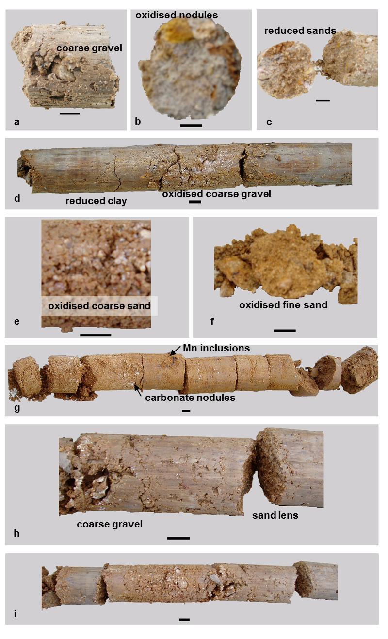
5 Figure S1. Subsections of cores from Piezo 2 (inside the palæochannel). Beneath the channel (a,b,c,d) a reduced layer of clay exists, which contains several deposits of coarse angular gravel and nodules of oxidised material. The top of the palæochannel (e,f,g) shows highly-oxidised fine and coarse sand with manganese inclusions and small carbonate nodules. The thick gravel deposit below the clay (h,i) contains significant amounts of sub-angular to sub-rounded gravel, similar in appearance to the thick deposit of gravel found below.
6 Figure S2. Cross section of the conceptualised palaeochannel system in VS2Di indicating the Soil Texture map with the location of observation points. The scale of the system is in meters. Each colour is a different soil texture (Table S2). Palæochannel data for hydraulic properties are applied in the middle section of the domain (approximately indicated by the black dashed line), while the rest of the domain is parameterised with no-channel hydraulic properties
7 Figure S3. Cross section of the pressure head equilibrium profile after 24 hours of drainage of the initial conditions and at the start of the irrigation infiltration (with a groundwater table at 6 m depth). The colour scale on the left indicates the pressure head in m in the profile being 0 for saturated and negative for drier conditions. Approximate location of the palæochannel sediments is indicated by the dashed black line.
8 Figure S4. Cross sectional profile of the pressure head after 8 hours with 10 mm pressure head of surface irrigation. Colour scale on the left represents pressure heads in m in the profile. Approximate location of the palæochannel sediments is indicated by the dashed black line.
9 Figure S5. Cross sectional profile of the pressure heads at the end of 12 hours of irrigation with 10 mm of pressure head. This is 36 hours in model time. Colour scale represents pressure heads in m in the profile. Approximate location of the palæochannel sediments is indicated by the dashed black line.

10 Figure S6. Cross sectional profile with final simulated pressure heads after 96 hours of transpiration post irrigation, 136 hours in model time. Colour scale represents pressure heads in m in the profile. Approximate location of the palæochannel sediments is indicated by the dashed black line.
Log of Monitoring Well D58B
 Project: Motiva - Monitoring Well and Soil Boring Data Project Location: Delaware City Refinery Project Number: 20240412.W1000 Log of Monitoring Well D58B Sheet 1 of 7 Date(s) Drilled Drilling Method Drill
 UNIT DESCRIPTIONS: Artificial Fill, Undocumented (Afu): Locally derived sandy silt and silty sand, locally with clay and varying amounts of gravel and man-made debris. Abundant concrete rubble, in places
4. Soils and soil conditions
 4. Soils and soil conditions 4.1 General characteristics 4.1.1 Soil-forming processes Most soils of the Bardenas area show no distinct characteristics of soil development. Except in the ancient alluvium
MAFF Ministry of IfiriLE Agriculture Fisheries and Food
 MAFF Ministry of IfiriLE Agriculture Fisheries and Food STATEMENT OF PHYSICAL CHARACTERISTICS AND AGRICULTURAL LAND CLASSIFICATION UPSLAND, KIRKLINGTON NORTH YORKSHIRE EXTRACTION OF SAND AND GRAVEL MARCH
Monitoring and modelling hydrological fluxes in support of nutrient cycling studies in Amazonian rain forest ecosystems Tobon-Marin, C.
 UvA-DARE (Digital Academic Repository) Monitoring and modelling hydrological fluxes in support of nutrient cycling studies in Amazonian rain forest ecosystems Tobon-Marin, C. Link to publication Citation
Evaluation/Monitoring Report No. 259
 SITE 100M EAST OF 16 LEARMORE ROAD CASTLEGORE CASTLEDERG COUNTY TYRONE LICENCE NO.: AE/13/36E NAOMI CARVER 1 Site Specific Information Site Name: 100m east of 16 Learmore Road, Castlederg, Co. Tyrone Townland:
Teelba. Soil summary sheets. Locality and site notes. Site Details
 Teelba Soil summary sheets Locality and site notes The Teelba sites characterise soil and regolith properties in the belah/brigalow and poplar box landscapes on sandstone. Soil properties along two transects
On-Site Soils Investigation. Buttermilk Way Storm water Treatment Project Buzzards Bay. MA. February 28 th, 2012
 1 On-Site Soils Investigation Buttermilk Way Storm water Treatment Project Buzzards Bay. MA February 28 th, 2012 Glenn Stanisewski, Resource Soil Scientist, USDA-NRCS, West Wareham, MA Introduction: The
DETERMINING SOIL PATTERNS IN SINGLETON TRAINING AREA NOT IDENTIFIED BY GEOLOGY AND CATENARY POSITION
 DETERMINING SOIL PATTERNS IN SINGLETON TRAINING AREA NOT IDENTIFIED BY GEOLOGY AND CATENARY POSITION Robert Gourlay and Brian Tunstall 1994 ABSTRACT A prior soil survey of the Singleton Training Area identified
Dashed line indicates the approximate upper limit boundary for natural soils. C L o r O L C H o r O H
 SYMBOL SOURCE 8 9 1 SOIL DATA NATURAL SAMPLE DEPTH WATER PLASTIC LIQUID PLASTICITY NO. CONTENT LIMIT LIMIT INDEX (%) (%) (%) (%) Client: County of Berthoud Project: Project No.: Boring B-2 S-1-5' 6.2 8
Parent Materials. & some of Seattle s soils
 Parent Material & some of Seattle s soils ESRM 311/SEFS 507 Week 3 SOILS = f(cl, r, o, p, t) Parent Materials 1) Sedentary a) residual (bedrock weathered in place) b) organic 2) Transported by a) gravity
Preliminary soil survey of the NATL Old Field Plots
 Preliminary soil survey of the NATL Old Field Plots The preliminary soil survey consisted of completing auger borings at 25 m intervals and included auger borings at total of 46 points. The borings were
Hydro One (Sept 2014) Hydro One (Sept 2014) Hydro One (Sept 2014)
 Hydro One (Sept 2014) Hydro One (Sept 2014)") TABLE 1 WELL CONSTRUCTION DETAILS MOE WWR No Well ID Location Installation Date Status Easting Coordinates Northing Source Elevation Screened Interval Screened Material Borehole Well Stick-up Ground Top
TABLE 1 WELL CONSTRUCTION DETAILS MOE WWR No Well ID Location Installation Date Status Easting Coordinates Northing Source Elevation Screened Interval Screened Material Borehole Well Stick-up Ground Top
Key Reference Site 12
 Key Reference Site 12 Site details MGA Coordinates: 661374 me 7457821 mn Zone 55 Lat/long: -22.98007 S 148.57429 E Primary site: SALTC 349 Geology: Cz - Undifferentiated Cainozoic sediments (colluvial
CRITERIA FOR DEFINING THE SERIES (DAR, 2006)
") CRITERIA FOR DEFINING THE SERIES (DAR, 2006) On the Soils Map of Catalonia (1:25 000), the soil series are defined on the basis of the following hierarchically organised criteria. Classification at the
CRITERIA FOR DEFINING THE SERIES (DAR, 2006) On the Soils Map of Catalonia (1:25 000), the soil series are defined on the basis of the following hierarchically organised criteria. Classification at the
Figure DR3. Constraints on the depth of the hiatus surface based on 10 Be concentration of middle core sample.
 GSA Data Repository Item 2018099 Del Vecchio, J., DiBiase, R.A., Denn, A.R., Bierman, P.R., Caffee, M.W., and Zimmerman, S.R., 2018, Record of coupled hillslope and channel response to Pleistocene erosion
MINERALOGICAL ALTERATIONS OF SOIL IRRIGATED WITH ACIDIC MINE WATER IN THE ALAMOSA RIVER BASIN
 MINERALOGICAL ALTERATIONS OF SOIL IRRIGATED WITH ACIDIC MINE WATER IN THE ALAMOSA RIVER BASIN by Stephanie J. Connolly Steve W. Blecker Grant E. Cardon Eugene Kelly Colorado State University, Department
Bachelor of Biosystems Technology Faculty of Technology South Eastern University of Sri Lanka
 Bachelor of Biosystems Technology Faculty of Technology South Eastern University of Sri Lanka BSE 11042 Principles of Irrigation Furrow Irrigation Running water in small channels (furrows) Water infiltration
Introduction to Soil Science and Wetlands Kids at Wilderness Camp
 Introduction to Soil Science and Wetlands Kids at Wilderness Camp Presented by: Mr. Brian Oram, PG, PASEO B.F. Environmental Consultants http://www.bfenvironmental.com and Keystone Clean Water Team http://www.pacleanwater.org
Key Reference Site 7. Site details. Climate 5. Queensland Key Reference Sites. Site location. Soil and landscape correlation. June 2006 QKRS 7-1
 Key Reference Site 7 Site details MGA Coordinates: 615229 me 7363243 mn Zone 55 Lat/long: -23.83805 S 148.13144 E Primary site: SALTC 342 Geology: PII - Alderabaran Sandstone /shale (Permian), Back Creek
6W9}* Appendix 2 to report No. P62 SOIL RESOURCES MAP OF TH E MPEKETONIAREA (LAMU AND TANA RIVER DISTRICTS) 40" 40 E LEGEND ISWC U8RAWY _& Jl W*g*n)ng
 40 40 E LEGEND ISWC U8RAWY _& Jl W*g*n)ng") 6W9}* Appendix 2 to report No. P62 SOIL RESOURCES MAP OF TH E MPEKETONIAREA (LAMU AND TANA RIVER DISTRICTS) 40" 40 E LEGEND ISWC U8RAWY _& Jl W*g*n)ng«ft, Tlw 9MtWt&nât COASTAL PLAINS (slopes less than
6W9}* Appendix 2 to report No. P62 SOIL RESOURCES MAP OF TH E MPEKETONIAREA (LAMU AND TANA RIVER DISTRICTS) 40" 40 E LEGEND ISWC U8RAWY _& Jl W*g*n)ng«ft, Tlw 9MtWt&nât COASTAL PLAINS (slopes less than
A. V T = 1 B. Ms = 1 C. Vs = 1 D. Vv = 1
 Geology and Soil Mechanics 55401 /1A (2002-2003) Mark the best answer on the multiple choice answer sheet. 1. Soil mechanics is the application of hydraulics, geology and mechanics to problems relating
Geology and Soil Mechanics /1A ( ) Mark the best answer on the multiple choice answer sheet.
 Mark the best answer on the multiple choice answer sheet.") Geology and Soil Mechanics 55401 /1A (2003-2004) Mark the best answer on the multiple choice answer sheet. 1. Soil mechanics is the application of hydraulics, geology and mechanics to problems relating
Geology and Soil Mechanics 55401 /1A (2003-2004) Mark the best answer on the multiple choice answer sheet. 1. Soil mechanics is the application of hydraulics, geology and mechanics to problems relating
Eastwood & Partners St. Andrew's House 23 Kingfield Road Sheffield S11 9AS. Co-ords: Level: Dimensions: Depth 1.50m
 epth (m) 0.0 Kingfield Road S AS Coords: imensions: epth.0m epth Level (m) (m AO) Stratum escription 0.0m.0m TOPSOIL: Brown sandy gravelly with rootlets. Gravel is angular to subrounded fine to coarse
SOIL REPORT FOR BINGARA GORGE DEVELOPMENT SITE Introduction
 SOIL REPORT FOR BINGARA GORGE DEVELOPMENT SITE Introduction On 16 March, 1 April 2016 and 21 September 2016 I undertook soil surveys at Bingara Gorge Development Site, Wilton, and prepared this soil report
PARQUE COLON AGUADILLA (LAND PROPERTY OF MUNICIPIO AGUADA) LOT PROPERTY OF SUNC. ESTEVEZ BW-1 BW-5 BW-2 DB1 BW-3 DB2 BW-4 DB3 GWS-1
 LOT PROPERTY OF SUNC. ESTEVEZ BW-1 BW-5 BW-2 DB1 BW-3 DB2 BW-4 DB3 GWS-1") N 64650 N 64600 N 64550 N 64500 N 64450 N 64400 N 64350 N 64300 N 64250 N 64200 N 64150 N 64100 N 64050 N 64000 N 63950 N 63900 N 63850 N 63800 N 63750 N 63700 N 63650 N 63600 N 63550 N 63500 N 63450 N
N 64650 N 64600 N 64550 N 64500 N 64450 N 64400 N 64350 N 64300 N 64250 N 64200 N 64150 N 64100 N 64050 N 64000 N 63950 N 63900 N 63850 N 63800 N 63750 N 63700 N 63650 N 63600 N 63550 N 63500 N 63450 N
Appendix A: Core descriptions
 Appendix A: Core descriptions Core: Tan0706 1 Water Depth: 2550m Gear: Piston Date Collected: 6/5/07 Date Described: 7/12/10 Description and Comments: 0-23 (2.5Y 6/4), light yellowish brown. Sandy silt.
Lecture 2: Soil Properties and Groundwater Flow
 ENGI 7718 Environmental Geotechniques ENGI 9621 Soil Remediation Engineering Lecture 2: Soil Properties and Groundwater Flow Spring 2011 Faculty of Engineering & Applied Science 1 2.1 Soil properties 2.1.1
Lowest and Youngest Terrace : Soil Pit #4
 Lowest and Youngest Terrace : Soil Pit #4 Observations : Where : Huntington Terraces Climate : Cloudy, mid 60 s Our soil pit was the lowest of the 4 sites The pit site was located on the right side of
Evaluation/Monitoring Report No. 152
 Evaluation/Monitoring Report No. 152 150m west of 7 Portmore Rd. Portmore Lower Ballinderry County Antrim LICENCE NO.: AE/07/241 David McIlreavy 1 Site Specific Information Site Name Townland County :
WELL NUMBER 14-BW03 PAGE 1 OF 5
 WELL 14-BW03 PAGE 1 OF 5 IENT PROJECT DATE STARTED 4/30/14 COMPLETED 5/1/14 GROUND ELEVATION 1157.89 ft HOLE SIZE 9 5/8 inches DRILLING CONTRACTOR Cascade Drilling NORTHING 670592.2 EASTING 1937845.8 DRILLING
STATEMENT OF PHYSICAL CHARACTERISTICS REPORT FOR WELLINGTON, HEREFORD AND WORCESTER MINERALS LOCAL PLAN
 STATEMENT OF PHYSICAL CHARACTERISTICS REPORT FOR WELLINGTON, HEREFORD AND WORCESTER MINERALS LOCAL PLAN M J Wood ADAS Ref: 25/RPT/0039 Resource Planning Team Job No: 164/94 ADAS Statutory Group MAFF Ref:
TEXTURE ANALYSIS. Unknown 1 Unknown 2. Unknown 3 6O 6O O Z 14X 10Z X X 8Z
 Unknown 1 Unknown 2 TEXTURE ANALYSIS Unknown 3 O 2O 10Z X X 8Z O 2X O Z 14X X 2O 6O 6O Parent Material & some of Seattle s soils ESRM 311/SEFS 507 Week 3 SOILS = f(cl, r, o, p, t) Parent Materials 1) Sedentary
Spatial modeling of pesticide emissions to groundwater and surface water in the Belgian context
 11/10/2012 Spatial modeling of pesticide emissions to groundwater and surface water in the Belgian context Bernhard s e-mail : 30 minutes => 20 minutes + 10 minutes discussion and award for best debater!
Weathering is the process that breaks down rock and other substances at Earth s surface
 Chapter 8 Notes Weathering is the process that breaks down rock and other substances at Earth s surface Factors that contribute to weathering Heat Cold Water Ice O 2 & CO 2 in the atmosphere Examples of
Procedure for Determining Near-Surface Pollution Sensitivity
 Procedure for Determining Near-Surface Pollution Sensitivity Minnesota Department of Natural Resources Division of Ecological and Water Resources County Geologic Atlas Program March 2014 Version 2.1 I.
Soil Surveys. What are the most important properties to consider in a taxonomic system used for making a soil survey?
 Soil Surveys What are the most important properties to consider in a taxonomic system used for making a soil survey? What is a Soil Survey? Inventory of soil resources Delineation of spatial distribution
BURIED SOILS OF GLOBE HILL, UPPER OHIO VALLEY
 BURIED SOILS OF GLOBE HILL, UPPER OHIO VALLEY HEBER D. LESSIG Soil Scientist, Box 248, Lisbon, Ohio A terrace, 5 mi downstream from Wellsville, Ohio, standing about 200 ft above the Ohio River, was recently
Feet. Cape May Core #51 Start depth: 240 ft Stop depth: 245 ft Recovery (ft): 5.1 ft Date: 3/21/94 Described by: JVB, KGM, CL. 5.
: 5.1 ft Date: 3/21/94 Described by: JVB, KGM, CL. 5.") SAND; medium to fine sand with abundant silt, homogenous slightly mottled appearance; mica on outside, mostly quartz; few darks; peat layer.9 - ft; cnv - same as above; the last few cores are all the same;
SAND; medium to fine sand with abundant silt, homogenous slightly mottled appearance; mica on outside, mostly quartz; few darks; peat layer.9 - ft; cnv - same as above; the last few cores are all the same;
 TP-1 N61E 0 DARK BROWN SANDY SILT (ML) stiff, wet with roots (Disturbed Surficial Soil) DEPTH (FEET) 5 REDDISH BROWN SANDSTONE intensely fractured, weak to friable, deeply weathered, tight (Franciscan
Rocks and Weathering
 Rocks and Weathering The Effects of Weathering The process of mountain building thrusts rock up to Earth s surface. Weathering is the process that breaks down rock and other substances at Earth s surface.
Correlation of Tills Exposed in Toledo Edison Dam Cut, Ohio
 The Ohio State University Knowledge Bank kb.osu.edu Ohio Journal of Science (Ohio Academy of Science) Ohio Journal of Science: Volume 60, Issue 2 (March, 1960) 1960-03 Correlation of Tills Exposed in Toledo
Curtis Monger USDA-NRCS Developments in Soil Taxonomy
 Curtis Monger USDA-NRCS Developments in Soil Taxonomy rice ANTHROPOCENE? Ca Curtis Monger USDA-NRCS Developments in Soil Taxonomy rice ANTHROPOCENE? Soil sustainability differs across the landscape. Ca
Standards and Procedures for Site Specific Soil Mapping in Rhode Island. Pg 1
 Standards and Procedures for Site Specific Soil Mapping in Rhode Island Pg 1 The Task Take This and Create This The Task Take This and Create This and a Report Pg 2 How is this different than the RI Soil
SUPPLEMENTAL MATERIAL
 SUPPLEMENTAL MATERIAL DESCRIPTIONS OF OTHER STRATIGRAPHIC SECTIONS Cherry Creek In its middle reaches, Cherry Creek meanders between three paired terraces within a narrow bedrock valley. The highest is
LANDFORM ANALYSIS AND SOIL RESOURCE INVENTORY USING REMOTE SENSING TECHNIQUE IN A WATERSHED OF UTTARANCHAL, INDIA
 LANDFORM ANALYSIS AND SOIL RESOURCE INVENTORY USING REMOTE SENSING TECHNIQUE IN A WATERSHED OF UTTARANCHAL, INDIA S.K.Mahapatra *, D. Martin, R.D.Sharma, S.P. Singh and J.P.Sharma National Bureau of Soil
Dundy County Test Hole Logs
 University of Nebraska - Lincoln DigitalCommons@University of Nebraska - Lincoln Conservation and Survey Division Natural Resources, School of 2007 Test Hole Logs Duane A. Eversoll University of Nebraska-Lincoln
Enhanced Characterization of the Mississippi River Valley Alluvial Aquifer Using Surface Geophysical Methods
 Photo by Shane Stocks, U.S. Geological Survey Enhanced Characterization of the Mississippi River Valley Alluvial Aquifer Using Surface Geophysical Methods Presented by Ryan F. Adams US Geological Survey
Assessment of Ground Water in a Part of Coastal West Bengal using Geo-Electrical Method
 Vol. 13, No. 2, pp. 203-210 (2013) Journal of Agricultural Physics ISSN 0973-032X http://www.agrophysics.in Research Article Assessment of Ground Water in a Part of Coastal West Bengal using Geo-Electrical
Master Horizons. O horizon A horizon E horizon B horizon C horizon R horizon W horizon O A E
 Soil Horizons Master Horizons O horizon A horizon E horizon B horizon C horizon R horizon W horizon O A E B C R W Master Horizons O horizon predominantly organic matter (litter and humus) A horizon zone
Influence of Paleochannels on Seepage
 Study 4 Influence of Paleochannels on Seepage Public Draft 2014 Monitoring and Analysis Plan September 2013 August 2012 Influence of Paleochannels on Seepage 1. Statement of Need Historical maps, aerial
Notes: Note. Township of GODSON Report NQ: 12. Diamond Dniiing. Hole NQ Footage Date. July/56. July/56. Aug/56. Aug/56. Claim NQ 487' K ' l-a
 Diamond Dniiing S2F«4NW«194 12 GODSON 010 Township of GODSON Report NQ: 12 Work performed by: KENNCO EXPLORATIONS (CANADA) LTD. Claim NQ Hole NQ Footage Date Note K 25434 l 487' July/56 l-a 48' July/56
Don Elsenheimer, Ph.D Glenn Melchert Minnesota Dept. Natural Resources
 Regional Survey of Gold in Till, Bigfork Greenstone Belt, St. Louis & Itasca Counties, Minnesota: Follow-up Trenching in Areas with Anomalously High Gold Grain Counts Don Elsenheimer, Ph.D Glenn Melchert
Although not essential, a good quality hand lens is a valuable addition to your field kit.
 Field Sediment Card Sediment characteristics are an important element in understanding marine and estuarine environments.there are thus a wide range of people (perhaps you!) who regularly use measurements
DIDSBURY FLOOD STORAGE BASIN, GREATER MANCHESTER
 DIDSBURY FLOOD STORAGE BASIN, GREATER MANCHESTER Archaeological Watching Brief Report Oxford Archaeology North August 2009 Environment Agency Issue No: 2009-10/971 OA North Job No: L10130 NGR: SJ 8415
Notes on Spatial and Temporal Discretization (when working with HYDRUS) by Jirka Simunek
 by Jirka Simunek") Notes on Spatial and Temporal Discretization (when working with HYDRUS) by Jirka Simunek 1. Temporal Discretization Four different time discretizations are used in HYDRUS: (1) time discretizations associated
Notes on Spatial and Temporal Discretization (when working with HYDRUS) by Jirka Simunek 1. Temporal Discretization Four different time discretizations are used in HYDRUS: (1) time discretizations associated
Effective unsaturated hydraulic conductivity for one-dimensional structured heterogeneity
 WATER RESOURCES RESEARCH, VOL. 41, W09406, doi:10.1029/2005wr003988, 2005 Effective unsaturated hydraulic conductivity for one-dimensional structured heterogeneity A. W. Warrick Department of Soil, Water
ψ ae is equal to the height of the capillary rise in the soil. Ranges from about 10mm for gravel to 1.5m for silt to several meters for clay.
 Contents 1 Infiltration 1 1a Hydrologic soil horizons...................... 1 1b Infiltration Process......................... 2 1c Measurement............................ 2 1d Richard s Equation.........................
Soil Profiles (West, Ch. 8)
") Geology 229 Engineering Geology Lecture 24 Soil Profiles (West, Ch. 8) We have just finished the discussion of rock weathering. One direct consequence of weathering is the formation of the soil profile.
Geology 229 Engineering Geology Lecture 24 Soil Profiles (West, Ch. 8) We have just finished the discussion of rock weathering. One direct consequence of weathering is the formation of the soil profile.
SOUTH CERRO AZUL STRATIGRAPHIC SECTION. Upper Cerro Azul flow of the Servilleta Basalt (Tsbcau) Lower Sandlin unit (Tsl)
 Lower Sandlin unit (Tsl)") Figure A3-01 cobbles claysilt general grain size sand pebbles vf f m c vc SOUTH CERRO AZUL STRATIGRAPHIC SECTION Top at 18 m. Upper Cerro Azul flow of the Servilleta Basalt (Tsbcau) 15 Basalt: Very dark
Figure A3-01 cobbles claysilt general grain size sand pebbles vf f m c vc SOUTH CERRO AZUL STRATIGRAPHIC SECTION Top at 18 m. Upper Cerro Azul flow of the Servilleta Basalt (Tsbcau) 15 Basalt: Very dark
Soils of the GLBRC Marginal Land Experiment (MLE) Sites
 Sites") KBS LTER Special Publication Soils of the GLBR Marginal Land Experiment (MLE) Sites. S. Kasmerchak and R. Schaetzl Department of Geography, Environmental, and Spatial Sciences Michigan State University
KBS LTER Special Publication Soils of the GLBR Marginal Land Experiment (MLE) Sites. S. Kasmerchak and R. Schaetzl Department of Geography, Environmental, and Spatial Sciences Michigan State University
Slide #2. What is the drainage pattern that you can see on this hillslope? What hillslope hydrologic phenomenon is well exemplified on this hillslope?
 Geology 22 Process Geomorphology Final Exam Fall, 1999 Name This exam is closed book and closed notes. Take some time to read the questions carefully before you begin writing. Answer the questions concisely
Landscapes & Hydric Soils Bruce Vasilas University of Delaware
 Landscapes & Hydric Soils Bruce Vasilas University of Delaware Hydric soils are defined as soils that formed under conditions of saturation, flooding, or ponding long enough during the growing season to
Appendix I SOIL RATING CHART. (Storie soil Index Rating = factor A* factor B* factor C* factor X) FACTOR A- Rating on character of Physical Profile
 FACTOR A- Rating on character of Physical Profile") Appendix I SOIL RATING CHART (Storie soil Index Rating = factor A* factor B* factor C* factor X) FACTOR A- Rating on character of Physical Profile Sr. No Particulars Percentage I Soil on recent alluvial
Appendix I SOIL RATING CHART (Storie soil Index Rating = factor A* factor B* factor C* factor X) FACTOR A- Rating on character of Physical Profile Sr. No Particulars Percentage I Soil on recent alluvial
16 January 2018 Job Number: RICHARD NEWMAN C\- CLARK FORTUNE MCDONALD AND ASSOCIATES PO BOX 553 QUEENSTOWN
 16 January 2018 Job Number: 50595 RICHARD NEWMAN C\- CLARK FORTUNE MCDONALD AND ASSOCIATES PO BOX 553 QUEENSTOWN CHANSEN@CFMA.CO.NZ STORMWATER DISPOSAL ASSESSMENT Dear Richard, RDAgritech were requested
' International Institute for Land Reclamation and Improvement. 2 Groundwater Investigations. N.A. de Ridder'? 2.1 Introduction. 2.
 2 Groundwater Investigations N.A. de Ridder'? 2.1 Introduction Successful drainage depends largely on a proper diagnosis of the causes of the excess water. For this diagnosis, one must consider: climate,
GLG 471; MICHIGAN STATE UNIVERSITY INSTRUCTOR R.L. VAN DAM PROJECT: ELECTRICAL RESISTIVITY
 GLG 471; MICHIGAN STATE UNIVERSITY INSTRUCTOR R.L. VAN DAM PROJECT: ELECTRICAL RESISTIVITY General information: This is a group (2-3 students) project requiring lab-, computer-, and fieldwork. Work will
Updating the Coupling Algorithm in HYDRUS Package for MODFLOW
 Updating the Coupling Algorithm in HYDRUS Package for MODFLOW SAHILA BEEGUM Guided by Dr. K P Sudheer, Dr. Indumathi M Nambi & Dr. Jirka Šimunek Department of Civil Engineering, Indian Institute of Technology
Appendix F Geotechnical Investigation
 Appendix F Geotechnical Investigation Cie Sucriere de Bel Ombre Ltee Residential Development at Bel Ombre Environmental Impact Assessment F1 Geotechnical Investigation This appendix includes the Factual
The Geology and Soils of the Southern Alice Springs District
 Agnote 316 No. G6 July 2005 Agdex No: 000/506 ISSN No: 0157-8243 The Geology and Soils of the Southern Alice Springs District A. White, formerly Senior Rangeland Production Officer, Alice Springs GEOLOGY
Topic 2 WRB MINERAL SOILS CONDITIONED BY (SUB-) ) HUMID CLIMATE. Albeluvisols, Luvisols and Umbrisols
 ) HUMID CLIMATE. Albeluvisols, Luvisols and Umbrisols") Topic 2 WRB MINERAL SOILS CONDITIONED BY (SUB-) ) HUMID CLIMATE Albeluvisols, Luvisols and Umbrisols Soil Forming Factors Significant period (season) when rainfall exceeds evapo-transpiration: Excess water
Topic 2 WRB MINERAL SOILS CONDITIONED BY (SUB-) ) HUMID CLIMATE Albeluvisols, Luvisols and Umbrisols Soil Forming Factors Significant period (season) when rainfall exceeds evapo-transpiration: Excess water
11/22/2010. Groundwater in Unconsolidated Deposits. Alluvial (fluvial) deposits. - consist of gravel, sand, silt and clay
 deposits. - consist of gravel, sand, silt and clay") Groundwater in Unconsolidated Deposits Alluvial (fluvial) deposits - consist of gravel, sand, silt and clay - laid down by physical processes in rivers and flood plains - major sources for water supplies
Groundwater in Unconsolidated Deposits Alluvial (fluvial) deposits - consist of gravel, sand, silt and clay - laid down by physical processes in rivers and flood plains - major sources for water supplies
Soils of Rhode Island
 Soils of Rhode Island Jim Turenne, RI State Soil Scientist USDA-NRCS 60 Quaker Ln. Suite 46 Warwick, RI. 02886 401-822-8830 http://nesoil.com Jim.turenne@ri.usda.gov About NRCS Established as the Soil
A prehistoric tsunami induced long lasting ecosystem changes on a semi arid. tropical island the case of Boka Bartol (Bonaire, Leeward Antilles)
") A prehistoric tsunami induced long lasting ecosystem changes on a semi arid tropical island the case of Boka Bartol (Bonaire, Leeward Antilles) Max Engel, Helmut Brückner, Peter Frenzel, Sascha Fürstenberg,
A prehistoric tsunami induced long lasting ecosystem changes on a semi arid tropical island the case of Boka Bartol (Bonaire, Leeward Antilles) Max Engel, Helmut Brückner, Peter Frenzel, Sascha Fürstenberg,
1. Water in Soils: Infiltration and Redistribution
 Contents 1 Water in Soils: Infiltration and Redistribution 1 1a Material Properties of Soil..................... 2 1b Soil Water Flow........................... 4 i Incorporating K - θ and ψ - θ Relations
Exploring the uncertainty of soil water holding capacity information
 Exploring the uncertainty of soil water holding capacity information Linda Lilburne*, Stephen McNeill, Tom Cuthill, Pierre Roudier Landcare Research, Lincoln, New Zealand *Corresponding author: lilburnel@landcareresearch.co.nz
Guidelines for Using the NTCHS Indicators of Hydric Soils. 1.NTCHS Indicators of Hydric Soils (p1)
") Guidelines for Using the NTCHS Indicators of Hydric Soils Outline: 1. Glossary of Terms and Guides Used with Soil Descriptions 2. Soil Plug Extraction Procedure 3. Caveats for Using the Indicators Ref:
Guidelines for Using the NTCHS Indicators of Hydric Soils Outline: 1. Glossary of Terms and Guides Used with Soil Descriptions 2. Soil Plug Extraction Procedure 3. Caveats for Using the Indicators Ref:
The potential of GIS in mapping soil health. Tim Brewer 19/11/2104
 The potential of GIS in mapping soil health Tim Brewer 19/11/2104 Horizon Depth (cm) Sand % Silt % Clay % ph Organic Carbon (wt%) Bulk Density (g/cm3) Particle Density (g/cm3) Total Porosity (%) Water
Geology of the Black River and Paw Paw River Watersheds. Dr. Tara Kneeshaw Grand Valley State University Department of Geology
 Geology of the Black River and Paw Paw River Watersheds Dr. Tara Kneeshaw Grand Valley State University Department of Geology Two Rivers Coalition September 11, 2013 There s nothing boring about Michigan
EXTENSION OF A HOTEL IN POIANA BRASOV ON AN INCLINED SLOPE
 Bulletin of the Transilvania University of Braşov Vol. 9 (58) - 2016 Series I: Engineering Sciences EXTENSION OF A HOTEL IN POIANA BRASOV ON AN INCLINED SLOPE M. MĂNTULESCU 1 I. TUNS 2 Abstract: Extension
GEOLOGIC LOG. sandy. coarse-grained, dark-green autochthonous glauconite; minor amount of sand-grade shell debris, foraminifers rare
 OWNER: William E. Hackney o (Rivercliff Subdivision) DRILLER: Pittman wood & Metal Products Co. COUNTY: Nansemond (Driver) VDMR: WWCR: TOTAL DEPTH: 2092 173 607' GEOLOGIC LOG Depth in feet COLUMBIA GROUP
Principles of soil water and heat transfer in JULES
 Principles of soil water and heat transfer in JULES Anne Verhoef 1, Pier Luigi Vidale 2, Raquel Garcia- Gonzalez 1,2, and Marie-Estelle Demory 2 1. Soil Research Centre, Reading (UK); 2. NCAS-Climate,
Environmental Impact Report for the proposed establishment of a New Coal-Fired Power Station in the Lephalale Area, Limpopo Province
 8. GEOLOGY, SOILS AND AGRICULTURAL POTENTIAL 8.1. Geology 8.1.1. Preferred Site Geology Naauwontkomen 509 LQ The geology on Naauwontkomen is similar to that of the neighbouring farm, Eenzaamheid 512 LQ.
Weathering, Erosion and Deposition
 Weathering, Erosion and Deposition Shaping the Earth s Surface Weathering the process of breaking down rocks into smaller fragments Erosion the transport of rock fragments from one location to another
Nitrate Distribution in a Deep, Alluvial Unsaturated Zone: Geologic Control vs. Fertilizer Management
 Nitrate Distribution in a Deep, Alluvial Unsaturated Zone: Geologic Control vs. Fertilizer Management Thomas Harter *, Katrin Heeren, William R. Horwath Department of Land, Air, and Water Resources University
DRILL HOLE # BH-BGC13-FN-01
 DILL HOLE # BH-BGC3-FN-0 Drill Method: Mud otary/coring Depth To ock (m): N/A Page of 7 eviewed by: AJB 0 GAVEL (GW) Fine to coarse, sandy, well graded, dense, max particle size = 30 mm, angular to subrounded,
Journal of Sedimentary Environments Published by Universidade do Estado do Rio de Janeiro SM2: doi: /jse SUPPLEMENTARY MATERIAL
 Appendix 2 Citation: Bergamaschi, S., Duarte, A.C.F., Serrano, J.S., Figueiredo, A.M.B., Vasconcelos, L.C., Oliveira, R.M.A.G., Ade, M.V.B., Pinheiro, A.E.P.P., Martins, M.V.A., 2016. Regional outcrops
LAB 4 FIELD STUDY OF SOIL: DESCRIBING SOIL HORIZON WITH SOIL PROPERTIES
 LAB 4 FIELD STUDY OF SOIL: DESCRIBING SOIL HORIZON WITH SOIL PROPERTIES Learning outcomes The student is able to: 1. describe the soil properties of soil horizons 2. describe the full description of a
Marine Sediments EPSS15 Spring 2017 Lab 4
 Marine Sediments EPSS15 Spring 2017 Lab 4 Why Sediments? Record of Earth s history - Tectonic plate movement - Past changes in climate - Ancient ocean circulation currents - Cataclysmic events 1 Classification
Chemistry of Tiling and Crusting
 Chemistry of Tiling and Crusting Tom DeSutter Assistant Professor of Soil Science NDSU Soil and Soil/Water Training 25 January 2012 What is Dispersion? Soil particles are repelled away from each other
Custom Soil Resource Report for Forrest County, Mississippi
 United States Department of Agriculture Natural Resources Conservation Service A product of the National Cooperative Soil Survey, a joint effort of the United States Department of Agriculture and other
DATE: 5/17/2012. LOGGED BY: Geoff Richards. COMPANY: Tetra Tech EM, Inc. DRILL FOREMAN: Walter
 ATTACHMENT 2 Page 1 of 1 B1 0 1 2 FILL, Dry; brownish red; clayey silt and gravel; ~30% gravel size fragments of dark grey microcrystalline (aphanetic), extrusive, igneous, rock 3 B1-4a 1100 B1-4b-duplicate
Surface Processes. Water Cycle. Evaporation Transpiration Condenstation Precipitation Infiltration Runoff
 s e s s roce S P e c urfa s e s s e c o r P e s c d r a a f C r Su iew Note v e R Water Cycle Evaporation Transpiration Condenstation Precipitation Infiltration Runoff Runoff The moving of water along
LAB 2 IDENTIFYING MATERIALS FOR MAKING SOILS: ROCK AND PARENT MATERIALS
 LAB 2 IDENTIFYING MATERIALS FOR MAKING SOILS: ROCK AND PARENT MATERIALS Learning outcomes The student is able to: 1. understand and identify rocks 2. understand and identify parent materials 3. recognize
Appendix A. Producer Statement Advisory Note
 Appendix A Producer Statement Advisory Note Ref. No. 17095 26 May 2017 PRODUCER STATEMENT CONSTRUCTION REVIEW (PS4) IMPORTANT ADVISORY NOTE The Building Consent Authority (BCA) frequently requires Producer
Weathering, Soil, and Mass Movements
 Tarbuck Lutgens Weathering, Soil, and Mass Movements 5.1 Weathering Mechanical Weathering Mechanical weathering occurs when physical forces break rock into smaller and smaller pieces without changing the
Beneath the sand of the Tanami Desert
 Beneath the sand of the Tanami Desert ARGA 2018, Wallaroo, SA Nadir de Souza Kovacs Ngururrpa program The program area covers the traditional land of the Parna Ngururrpa People in a remote part of the
Chapter 6. Weathering, Erosion, and Soil
 Chapter 6 Weathering, Erosion, and Soil Introduction Rocks and minerals disintegrate and decompose by the processes of physical and chemical weathering. This breakdown occurs because the parent material
Diagnostic Geomorphic Methods for Understanding Future Behavior of Lake Superior Streams What Have We Learned in Two Decades?
 Diagnostic Geomorphic Methods for Understanding Future Behavior of Lake Superior Streams What Have We Learned in Two Decades? Faith Fitzpatrick USGS WI Water Science Center, Middleton, WI fafitzpa@usgs.gov
What Is Water Erosion? Aren t they the same thing? What Is Sediment? What Is Sedimentation? How can Sediment Yields be Minimized?
 Jerald S. Fifield, Ph.D. CISEC HydroDynamics Incorporated Parker, CO 303-841-0377 Aren t they the same thing? What Is Sediment? Soil particles deposited or suspended in water or air The process of depositing