4. Soils and soil conditions
|
|
|
- Eugenia Parsons
- 5 years ago
- Views:
Transcription
1 4. Soils and soil conditions 4.1 General characteristics Soil-forming processes Most soils of the Bardenas area show no distinct characteristics of soil development. Except in the ancient alluvium of the mesas, soil-forming processes have had little time to act upon the very recent parent materials of alluvial and colluvial origin. Moreover, the climate being characterized by a marked aridity, an excess of water rarely occurs owing to the low amount of precipitation and its even distribution. Therefore, except for the soils of the mesas, there is little soil profile development. The soils of the mesas, formed over a much longer period, have diagnostic cambic and calcic, or petrocalcic horizons. The other soils, apart from an ochric epipedon, show the beginnings of argillic, calcic, gypsic and even salic horizons but only in a very incipient stage. Two soil-forming factors are relevant in understanding the origin and extent of the salt-affected soils of the area. These factors are parent material and the relative position of each soil association within the 1 and s cap e. 4. I.2 Parent materials Parent materials can be grouped into three classes. First is the ancient coarse alluvium of the mesas, which consists of well-rounded stones, gravel, and coarse sand. Above this layer a reddish loamy generally stoneless layer occurs. Both the coarse and the reddish layers are rich in calcium carbonate and are salt-free. 45
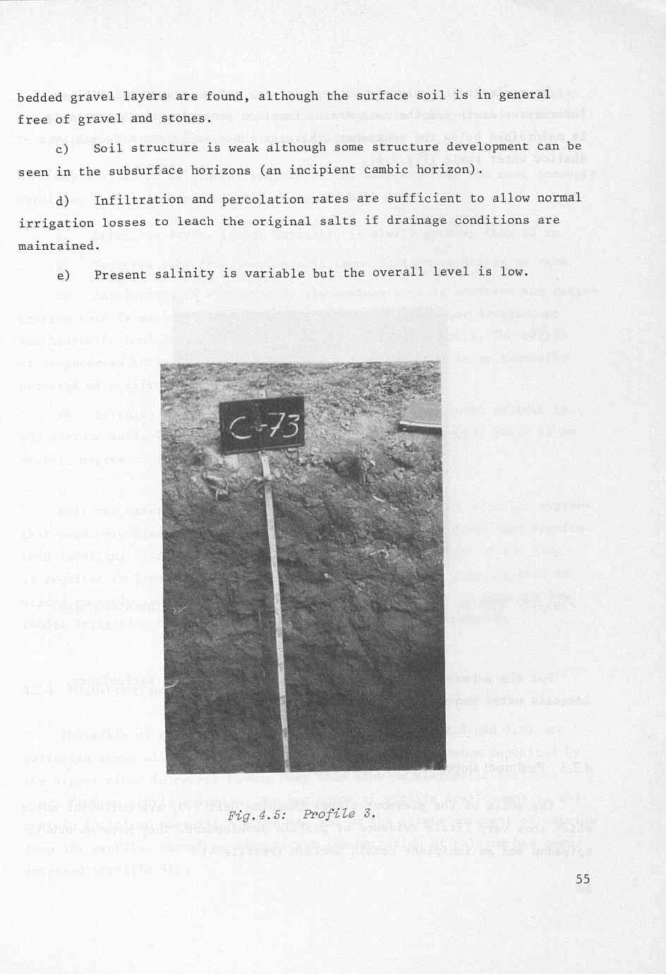
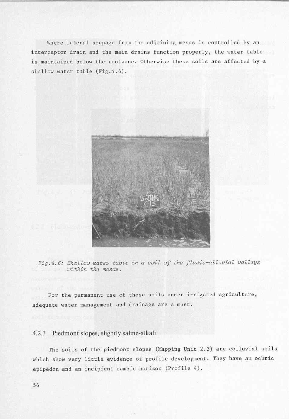
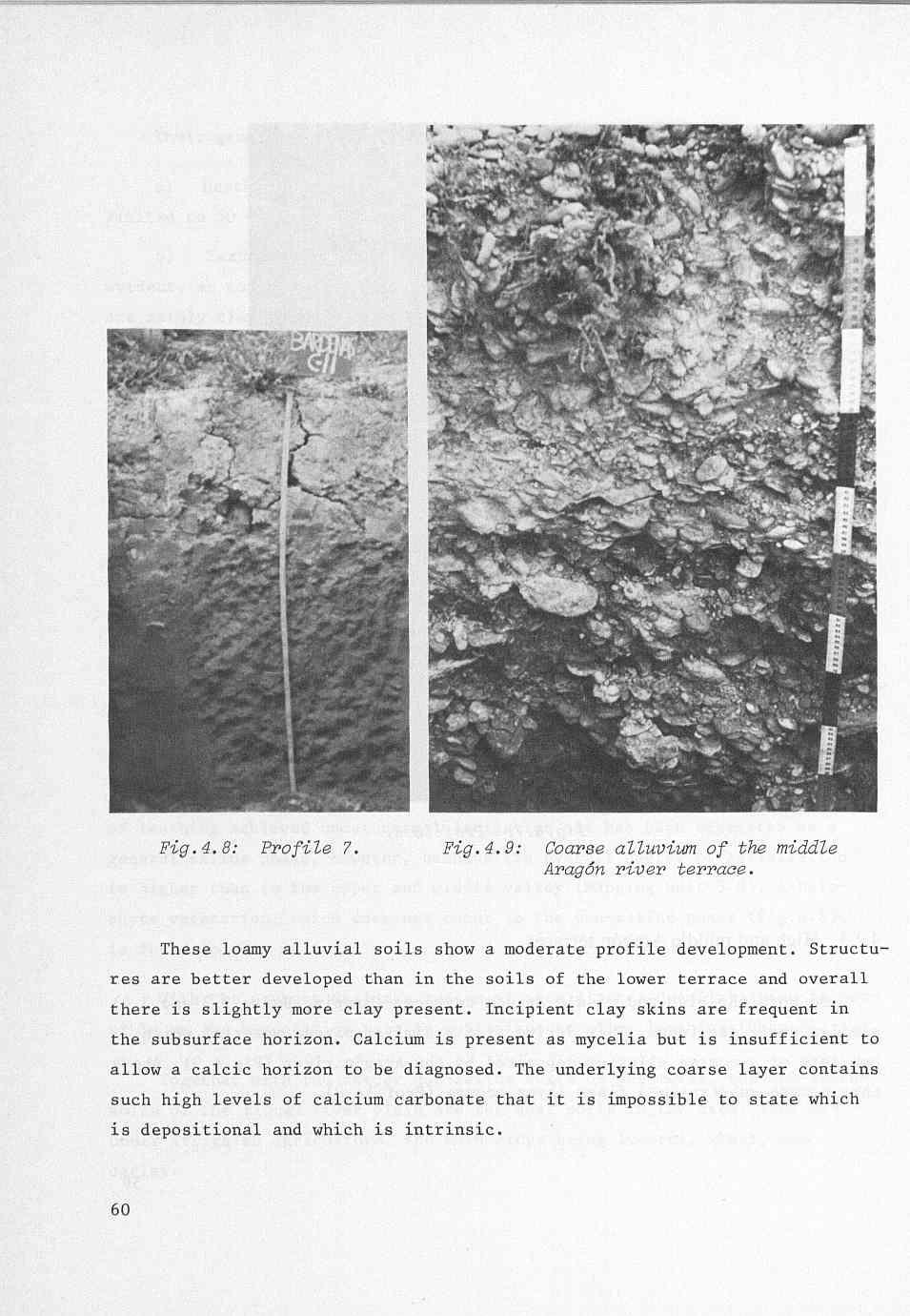
2 Second are the parent materials of alluvial origin brought by the two main water courses flowing through the area - the AragÓn and Riguel rivers - whose catchment areas are respectively outside and just at the edge of the Miocene-Oligocene sedimentation basin. The parent materials of the AragÓn valley soils are salt-free coarse alluvium in the medium and higher terraces and loamy sands in the lower terrace. In the Riguel valley a fine alluvium is found, which consists of clay loam and is salt-free in the upper part of the valley. Both clay content and salinity increase towards the lower end of the valley. A narrow sandy levee not sufficiently wide to be represented on the map can be distinguished. The third class of parent materials are those derived from the saline mudstone and siltstone, which are characterized by a very high percentage of silt. In the alluvial valleys and fans a fine alluvium has been deposited and in the lower parts of the slopes a fine colluvium. Both occur mixed in the fluvio-colluvial valleys. In the upper part of the piedmont slopes the parent material is mainly weathered mudstone. As these rocks are widespread throughout the area, soil texture varies within a narrow range, silt loam and loam being the most common textures. Salinity, though always present in these parent materials, is highly variable. In general the amounts of salts are highest in the low-lying alluvial formations (Chaps.2 and 3). High calcium carbonate content (>40%) is a common property of the soils. In non-saline soils ph varies between 7.5 and 8. In soils with higher sodium content higher ph-values are common (8 to 8.5) Topography The soils of the mesas, fluvial terraces, and alluvial valleys and plains are flat. The eroded plain has an undulating topography with gentle slopes and flat low-lying fluvio-colluvial valleys. Stony ridges and mesa escarpments have a pronounced slope. Topography has had a marked effect on the redistribution of salinity. The colluvial and piedmont slopes have loet salts which have accumulated in the lower flat areas (Chap.3).
3 4.1.4 Land and water management Where the soils of the slopes have been levelled, the original soil profile has been truncated. Sometimes less pervious and more saline layers, previously deep, form the present surface soil. The flat soils of the mesas and alluvial valleys required only a slight smoothing of the land and the present soil represents only a slight re-arrangement of the original profile. Irrigation has also played a role in the redistribution of salts. The percolation losses inherent in surface irrigation have leached the salts from the more permeable soils and carried them to other soils, particularly to soils deficient in natural drainage. 4.2 Mapping units During the reconnaissance survey which formed the basis upon which the soil map was prepared, the physiographic approach was applied. The objective of the reconnaissance survey was to delineate the saline and potentially saline areas for their subsequent reclamation under irrigation. The mapping units are therefore based on those conditions that were relevant to the specific practical agricultural purpose of the survey, namely the salinity hazard and the land reclamation possibilities. The mapping units thus represent landscape units based on the geomorphological features of land forms, slope, elevation and relative situation, parent materials, and drainage conditions. As has been described in the preceding chapters, all these features contribute to soil salinity. The soil map prepared in this way is shown in Figa.4.1 and 4.2. The main mapping unit is a landscape or geomorphological unit. Some subdivisions Were =de on the basis of soil salinity level and drainage conditions. Erosion hazard also had to be added because it is a condition that radically affects the land suitability for irrigation. 47
4 Each mapping unit is equivalent to a broad soil association but with a similar salinity range and similar drainage conditions. Some miscellaneous land types are also included. They indicate land with little or no soils, which serve no purpose for irrigated agriculture, and whose soil conditions were therefore not studied. To standardize the various investigations and to ease correlation with soils of other areas, representative soil profiles were morphometrically classified. Descriptions of soil profiles are in conformity with the Soil Survey Manual (1951). Most of the soil analyses were done in line with those of Agric. Handbook No.60 of the USDA (1955). Soil classification was based on Soil Taxonomy, Agric. Handbook No.936, USDA (1975). Four main zones, each of them related to a drainage basin, can be distinguished on the soil map (Chap.3). The northern "Rough Eroded Plain" has a complicated soil pattern (cross-section in Fig.2.8). It comprises residual siltstone outcrops in the highest position and saline alluvial soils in the low-lying fluvio-colluvial valleys and plains. The transition between the two mapping units is formed by soils of eroded slopes in the upper part of the hills and soils of colluvial slopes in the middle and lower parts of the slope. The north-western part of the area is dominated by the "AragÓn Alluvial Valley" (see cross-section in Fig.2.7) where soils of fluvial terraces are found. In the south this zone is bordered by a high mesa situated outside the irrigation scheme. Between the alluvial soils of the valley and the higher soils of the mesa, transitional soils occur on piedmont slopes. The same soil pattem dominates the south-eastem zone of the area as well (Fig.Z.lO). The soils of the mesas occupy the highest position and the soils of the Riguel alluvial plain the lowest. The soils of the? piedmont slopes form a transition between the two. The south-western major zone of "Piedmont slopes" has a highly irregular 48
5 soil pattern (Fig.2.12). It is composed of residual soils of the stony ridges and miscellaneous land in the highest position, and saline alluvial soils in the low-lying alluvial valleys and fans. Eroded slopes are situated between the residual soils and the depositional ones. The mapping units and their main features for irrigated agriculture are described in the following paragraphs. Fig.4.1: Physiographic soil map of the Bardenas area. Sheet I - Aragbn basin. (&Se map drawn from aerial photographs on an appr&ate scale of 1 : ). For legend, see p
6 L E G E N D PHYSIOGRAPHIC SOIL MAP OF THE BARDENAS AREA Physiographic soil units Residual soils of mesas and hills 1.1 soils of the mesas (sasos) 1.2 soils of the mesas, isolated phase 1.3 rough mountainous land 1.4 siltstone outcrops 1.5 soils of the stony ridges 1.6 stony ridges, eroded phase 1.7 gypsum ridges Eroded soils and badlands 2.1 terrace escarpments 2.2 soils of the piedmont slopes, slightly eroded phase 2.3 soils of the piedmont slopes, slightly saline-alkali phase 2.4 eroded slopes 2.5 erosion valleys 2.6 soils of alluvial fans, eroded phase 2.7 soils of the colluvial slopes Soils of valleys and terraces mixed alluvial land of the Arag6n river soils of the low Arag6n terrace, excessively drained phase soils of the middle Arag6n terrace soils of the high Arag6n terrace, slightly eroded phase soils of the Riguel river plain soils of the Riguel river plain, saline-alkali phase soils of the gypsum valleys soils of the fluvio-colluvial valleys, imperfectly drained and saline-alkali phase soils of the fluvio-colluvial valleys, slightly salinealkali phase soils of the alluvial plains, imperfectly drained and saline-alkali phase soils of alluvial valleys, saline-alkali phase soils of alluvial fans, slightly saline phase soils of alluvial fans, saline-alkali phase SU
7 Fig.4.2: Phgsiogmphic soil map of the Bardenas area. Sheet 11 - Riguel basin. (Base map drm from aerial photographs on an appm~mate scale of I : ). 51
8
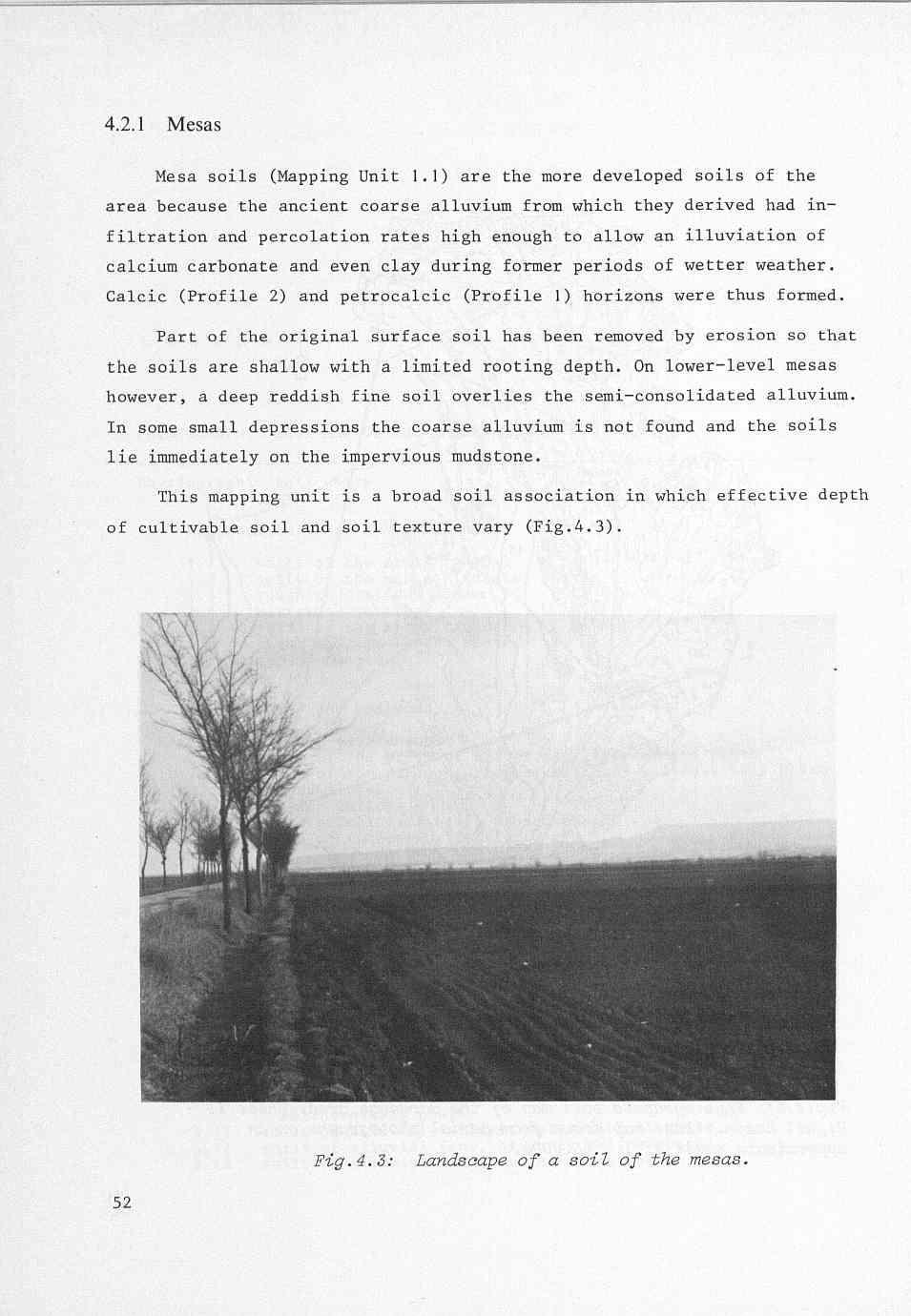
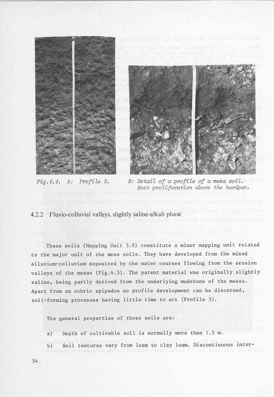
9 As the purpose of the survey was to map saline areas and as this soil association is in general free of salinity, phases of slightly different soils were not defined, except in an isolated phase (1.2) for remnants of eroded mesas which are out of the irrigation command. The general soil properties of the mesa soils are: a) Depth above the petrocalcic horizon varies between 30 and 80 cm. Root proliferation is well developed in the surface soil and even the petro- calcic horizon is occasionally penetrated. b) Textures vary from sandy loam to silt loam, although soils may become more sandy with depth. c) In the shallowest soils the degree of stoniness is high, but in general the surface soil is free of stones and gravel. d) Structure is weakly to moderately developed although the surface soil generally has a strong crumb structure. e) Infiltration and percolation rates are more than adequate to allow water to pass through the soil profile. The transmissivity value is sufficient to permit adequate drainage (Chap.3). Total moisture-holding capacity varies with the soil textures and effective depths of soil. f) Salinity is uncommon but slight salinization can occur in depressions where the coarse alluvium is only shallow over underlying impervious mudstone (Chap.5). g) There is a rapid increase in calcium carbonate content with depth, being highest in the calcic and petrocalcic horizons. h) Soil colour above the calcic and petrocalcic horizons is normally 7.5 YR 4/4. Where the soils of the mesas are moderately deep (Fig.4.4), prosperous irrigated agriculture has been established. Maize, lucerne, sugar-beet, barley, and tomato are the main crops. Effective depth of cultivable soil and moisture-holding capacity are the main soil features on which land suitability for irrigation depends. 53
10
11
12
13 Variation in these soils is considerable as their only-common features are a certain degree of slope and their situation in water-transit areas. In addition an eroded phase (2.2) is distinguished. Any discussion of general properties can only consider the most commonly occurring soils, the general properties of which are: a) Effective depth, though variable, is always greater than 50 cm. b) Textures vary from loam to silt loam. Surface stoniness is rare. c) Development of structure in the surface soil is moderate and infil- tration rate is adequate. The subsoil shows little structure development and hydraulic conductivity is low on the finer textured soils. The degree of compactness increases with depth and the less pervious layer generally consists of a siltstone or mudstone layer. d) Salinity is highly variable. Though it is not always evident in the surface soil, it is frequently encountered in the subsoil. There is an overall degree of intrinsic salinity in this unit (Chap.5). Soil and water management require careful attention. Irrigation systems that need only minor earth moving should be preferred to those that require land levelling. Irrigation with water in excess of the needs of the crop is required to leach salts to deeper layers, but careful water control is needed to avoid secondary salinization by lateral seepage in adjacent low lands. Irrigation by sprinkler could achieve both objectives Riguel river plain The soils of the Riguel river plain (Mapping Units 3.5 and 3.6) are yellowish brown alluvial soils derived from the fine alluvium deposited by the Riguel river in recent times. They thus show no diagnostic horizons apart from an ochric epipedon. The beginning of profile development is evident in incipient subsurface structure and in the slight movement of calcium down the profile, though no significant concentration of calcium has been detected (Profile 5). 57
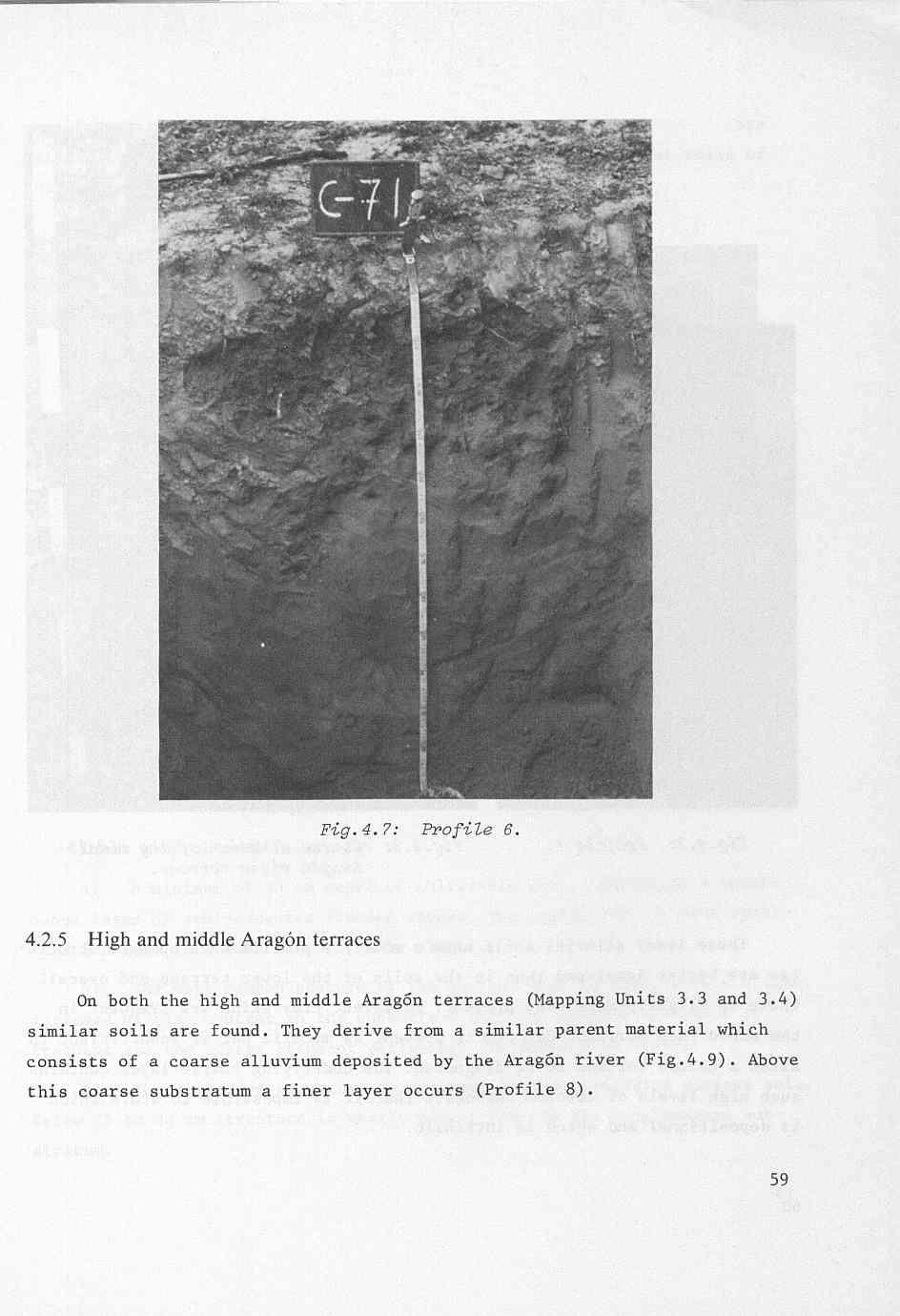
14 Their general properties are: a) Depth is generally greater than 2 m, but root proliferation is limited to 50 cm. b) Textures vary down the profile and signs of stratification are evident, as could be expected in young alluvial soils. The surface textures are mainly clay loam. Stones are rare. c) Structure development is weak and often non-existent, particularly in the subsoil. d) Soil moisture-holding capacity is the highest of all the soils of the studied area. Infiltration and percolation rates, though low, are suf- ficient to allow surface irrigation. In general no water table is found in the upper 3 m (Chap.3). e) The surface soil is free of salts but below 2 m soil salinity increases to an overall value slightly higher than 4 mhos. Profile 5 represents a characteristic soil of the middle valley. The clay content increases in the lower part of the plain (Profile 7). The narrow natural levee of the river consists of very recent sandy soils (Profile 6, Fig.4.7). In the lower valley soil salinity varies in accordance with the amount of leaching achieved under normal irrigation. It has been separated as a general saline phase, however, because its overall degree of salinization is higher than in the upper and middle valley (Mapping unit 3.6). A halo- phyte vegetation, which does not occur in the non-saline phase (Fig.4.8), is found in this unit. With the present drainage system of open ditches desalinization is pos- sible as the percolation rate is sufficient to allow leaching (Chap.5). Together with the deeper non-saline soils of the mesas, the non-saline soils of the Riguelriver plain are the best soils in the area. They are under irrigated agriculture, the main crops being lucerne, wheat, and barley. 58.I
15
16
17
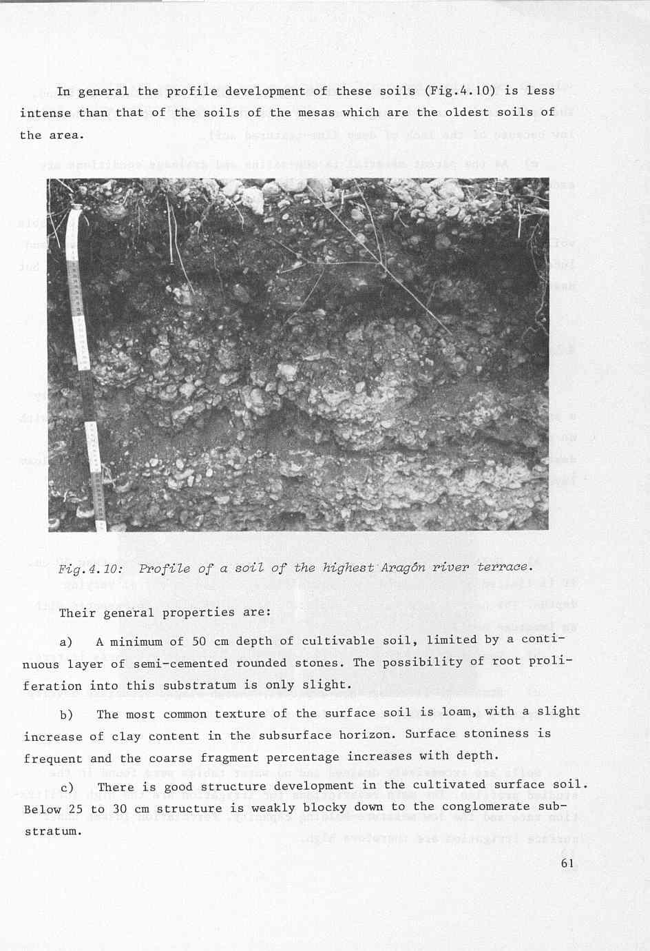
18 d) Internal drainage is extremely good and no water table is found. The infiltration rate is high, and the moisture-holding capacity moderately low because of the lack of deep fine-textured soil. e) As the parent material is non-saline and drainage conditions are excellent, the soils are free of salinity. The main restrictions for irrigated agriculture are depth of cultivable soil and surface stoniness, which prevent the cultivation of sugar beet and lucerne. Cereal crops, maize, and soya bean are cultivated successfully, but need frequent small irrigation applications Low Aragón terrace The soils of the low AragÓn terrace (Mapping Unit 3.2) represent only a small part of the total area. They are deep sandy loam alluvial soils with no profile development (Fig.4.11). Stratification is evident at moderate depth, with gravel and coarse sand layers interbedded between the sandy loam layers (Profile 9). The general properties are: a) Depth of cultivable soil, though variable, is greater than 50 cm. It is limited by the cobbles and gravel layers which appear at varying depths. The coarse alluvium is completely loose, as might be expected with an immature soil. b) Textures vary from loam to sandy loam. Surface stoniness is rare. c) Structure is almost non-existent, though slight structure development appears in the cultivated surface soil. Soils are excessively drained and no water tables were found in the studied profiles. The main restrictions for irrigation are the high infiltration rate and the low moisture-holding capacity. Percolation losses under surface irrigation are therefore high. 62 I
19
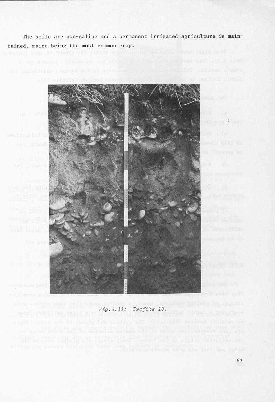
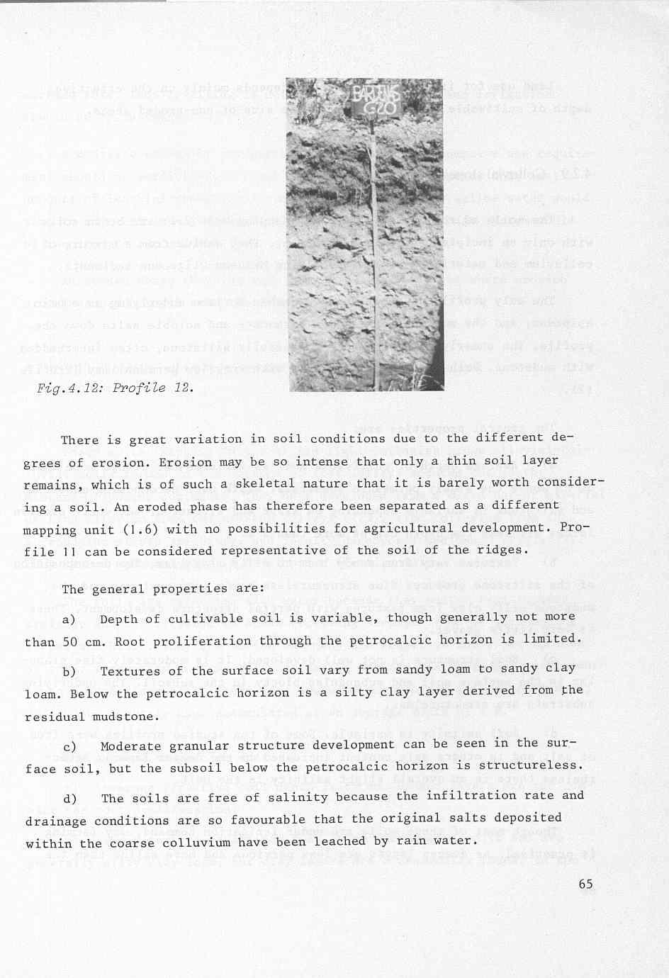
20 4.2.7 Gypsum valleys Some light brown alluvial soils occur within the gypsum valleys (Mapping Unit 3.7). They have no diagnostic horizons but an ochric epipedon and a cambic horizon. Calcium sulphate accumulation in the horizon underlying the cambic horizon is tending to become a gypsic horizon (Profile 10). The general properties are: a) Effective depth of cultivable soil is generally more than 1 m. There are abundant roots in the upper 50 cm. b) Soil texture varies from silty clay loam to clay, with indications of clay movement down the profile. Some gravel layers occur at depth, but in general no lateral continuity of the soil profile exists. c) Some structure development is occurring in the surface soil, but decreases with depth. d) The soils are affected by salinity, sodium chloride being the most common salt. Calcium sulphate accumulations are observed at depth (Chap.5). At present these soils are not cultivated. The observed leaching of calcium sulphate by rain water means that the percolation rate would be sufficient to leach more soluble salts if the amount of leaching water were to be increased with irrigation Stony ridges The soils are derived from an ancient colluvium of coarse fragments. They have developed in the same manner as the mesas soí s and in general consist of similar horizons, namely a reddish sandy clay loam surface soil overlying a cambic horizon which in turn overlies a light yellowish brown petrocalcic horizon (Fig.4.12). The cobbles and gravel of the stony ridges are less rounded than those of the coarse alluvium of the mesas owing to the colluvial origin of the former. Their slopes are greater than on the mesas and they are more severely eroded.
21
22 Land use for irrigated agriculture depends mainly on the effective depth of cultivable soil and the relative size of non-eroded areas Colluvial slopes The soils of the colluvial slopes (Mapping Unit 2.7) are brown soils with only an incipient profile development. They derive from a mixture of colluvium and material from the underlying Miocene-Oligocene sediments. The only profile development is a cambic horizon underlying an ochric epipedon, and the movement of calcium carbonate and soluble salts down the profile. The underlying substratum is generally siltstone, often interbedded with mudstone. Both are saline sediments with very low permeability (Profile 12). The general properties are: a) Average depth of cultivable soil is variable but always more than 50 cm above the slowly permeable substrata. Depth over decomposing mudstone and siltstone is variable depending on slope and situation, but where erosive forces are less the depth can be more than 2 m. b) Textures vary from sandy loam to silty clay loam. The decomposition of the siltstone produces fine structureless sandy loam textures and the mudstone silty clay loam textures with partial structure development. There is very little gravel. c) Soil structure is not well developed. It is moderately fine granular in the surface soil and subangular blocky in the subsoil. The underlying substrata are structureless. d) Soil salinity is variable. Some of the studied profiles were free of salt and in others salt content increased in the deeper layers. Never- theless there is an overall slight salinity in the unit. Though most of these soils are under irrigation command, dry farming is practised. As deeper layers are less pervious and more saline than the 66
MAFF Ministry of IfiriLE Agriculture Fisheries and Food
 MAFF Ministry of IfiriLE Agriculture Fisheries and Food STATEMENT OF PHYSICAL CHARACTERISTICS AND AGRICULTURAL LAND CLASSIFICATION UPSLAND, KIRKLINGTON NORTH YORKSHIRE EXTRACTION OF SAND AND GRAVEL MARCH
Chapter 2. Regional Landscapes and the Hydrologic Cycle
 Chapter 2. Regional Landscapes and the Hydrologic Cycle W. Lee Daniels Department of Crop and Soil Environmental Sciences, Virginia Tech Table of Contents Introduction... 23 Soils and landscapes of the
Monitoring and modelling hydrological fluxes in support of nutrient cycling studies in Amazonian rain forest ecosystems Tobon-Marin, C.
 UvA-DARE (Digital Academic Repository) Monitoring and modelling hydrological fluxes in support of nutrient cycling studies in Amazonian rain forest ecosystems Tobon-Marin, C. Link to publication Citation
Soil Map Boulder County Area, Colorado (Planet Blue Grass) Web Soil Survey National Cooperative Soil Survey
 Web Soil Survey National Cooperative Soil Survey") 475910 476000 476090 476180 476270 476360 105 16' 21'' W 476450 476540 476630 476720 476810 4453350 4453440 4453260 4453350 4453170 4453260 4453080 4453170 4453080 475820 475910 4452990 476000 476090 476180
475910 476000 476090 476180 476270 476360 105 16' 21'' W 476450 476540 476630 476720 476810 4453350 4453440 4453260 4453350 4453170 4453260 4453080 4453170 4453080 475820 475910 4452990 476000 476090 476180
3.3 CLIMATE, GEOLOGY, TOPOGRAPHY, AND SOILS CLIMATE GEOLOGY TOPOGRAPHY
 3.3 CLIMATE, GEOLOGY, TOPOGRAPHY, AND SOILS This section describes the climate, geology, topography, and soil resource characteristics of the Yolo Bypass Wildlife Area (Wildlife Area). Agricultural soil
Soil Map Polk County, Florida
 Soil Map Polk County, Florida 28 9' 21'' 28 8' 23'' 3113000 3113200 3113400 3113600 3113800 3114000 3114200 3114400 3114600 81 51' 19'' 81 51' 19'' 416000 416000 ± 416200 416200 68 416400 68 416400 7 13
Custom Soil Resource Report for Forrest County, Mississippi
 United States Department of Agriculture Natural Resources Conservation Service A product of the National Cooperative Soil Survey, a joint effort of the United States Department of Agriculture and other
SOIL INFORMATION FOR PUMPED WATER STORAGE SCHEME, STEELPOORT VALLEY
 REPORT On contract research for Bohlweki Environmental SOIL INFORMATION FOR PUMPED WATER STORAGE SCHEME, STEELPOORT VALLEY February 2007 By D.G. Paterson ARC-Institute for Soil, Climate and Water, Private
Sediment and sedimentary rocks Sediment
 Sediment and sedimentary rocks Sediment From sediments to sedimentary rocks (transportation, deposition, preservation and lithification) Types of sedimentary rocks (clastic, chemical and organic) Sedimentary
Maggie Payne Jim Turenne
 Maggie Payne Jim Turenne USDA-NRCS 60 Quaker Lane, Suite 46 Warwick, RI. 02886 401-822-8832 maggie.payne@ri.usda.gov U.S. Department of Agriculture 1935: Soil Conservation Service (SCS) Natural Resources
SUPPLEMENTAL MATERIAL
 SUPPLEMENTAL MATERIAL DESCRIPTIONS OF OTHER STRATIGRAPHIC SECTIONS Cherry Creek In its middle reaches, Cherry Creek meanders between three paired terraces within a narrow bedrock valley. The highest is
PHYSIOGRAPHIC POSITION: LOCAT I ON : DATE : LAND USE: PARENT MATERIAL : TOPOGRAPHY : DRAINAGE : SAL IN1 TY : DIAGNOSTIC HORIZONS: CLASSIFICATION:
 P R O F I L E I PHYSIOGRAPHIC POSITION: Mesa (mapping unit 1.1) LOCAT I ON : Carcastillo, Llano de Larrate DATE : August 28, 1976 LAND USE: cereal crops @ry farming) PARENT MATERIAL : ancient general alluvium
Erosion Surface Water. moving, transporting, and depositing sediment.
 + Erosion Surface Water moving, transporting, and depositing sediment. + Surface Water 2 Water from rainfall can hit Earth s surface and do a number of things: Slowly soak into the ground: Infiltration
Lecture 6: Soil Profiles: Diagnostic Horizons
 Lecture 6: Soil Profiles: Diagnostic Horizons Complexity in Soil Profiles Soil Horizons Soils display distinct layering O Horizon: Partially decomposed organic matter (OM) A Horizon: Near surface, mineral
Standards and Procedures for Site Specific Soil Mapping in Rhode Island. Pg 1
 Standards and Procedures for Site Specific Soil Mapping in Rhode Island Pg 1 The Task Take This and Create This The Task Take This and Create This and a Report Pg 2 How is this different than the RI Soil
Custom Soil Resource Report Soil Map
 121 3' 56'' W Custom Soil Resource Report Soil Map 121 2' 49'' W 45 16' 39'' N 5013800 5014000 5014200 5014400 5014600 5014800 5015000 5015200 5015400 5015600 651800 652000 652200 652400 652600 652800
Weathering, Erosion and Deposition
 Weathering, Erosion and Deposition Shaping the Earth s Surface Weathering the process of breaking down rocks into smaller fragments Erosion the transport of rock fragments from one location to another
Soil Surveys. What are the most important properties to consider in a taxonomic system used for making a soil survey?
 Soil Surveys What are the most important properties to consider in a taxonomic system used for making a soil survey? What is a Soil Survey? Inventory of soil resources Delineation of spatial distribution
Supplementary Material: Crop & Pasture Science, 2013, 64(12),
,") 10.1071/CP13168_AC CSIRO 2013 Supplementary Material: Crop & Pasture Science, 2013, 64(12), 1182 1194. Hydrological and water-use efficiency implications of geomorphological stratification in palæochannels
10.1071/CP13168_AC CSIRO 2013 Supplementary Material: Crop & Pasture Science, 2013, 64(12), 1182 1194. Hydrological and water-use efficiency implications of geomorphological stratification in palæochannels
Geology and New England Landscapes
 Geology and New England Landscapes Jim Turenne, CPSS USDA-NRCS Warwick, RI. http://nesoil.com Why Geology? Provides the big picture of site conditions. Major part of soil formation (parent material and
Temperature and Precipitation. Next stage will depend on climate and parent materials
 Next stage will depend on climate and parent materials Rainfall and temperature will determine nature of vegetation Resistance of parent material to weathering will determine rate and type of clay formation,
Appendix I SOIL RATING CHART. (Storie soil Index Rating = factor A* factor B* factor C* factor X) FACTOR A- Rating on character of Physical Profile
 FACTOR A- Rating on character of Physical Profile") Appendix I SOIL RATING CHART (Storie soil Index Rating = factor A* factor B* factor C* factor X) FACTOR A- Rating on character of Physical Profile Sr. No Particulars Percentage I Soil on recent alluvial
Appendix I SOIL RATING CHART (Storie soil Index Rating = factor A* factor B* factor C* factor X) FACTOR A- Rating on character of Physical Profile Sr. No Particulars Percentage I Soil on recent alluvial
Custom Soil Resource Report Soil Map
 77 35' 22'' W Custom Soil Resource Report Soil Map 77 35' 0'' W 282170 282220 282270 282320 282370 282420 282470 282520 282570 282620 40 59' 2'' N 40 58' 52'' N 4539900 4539950 4540000 4540050 4540100
STATEMENT OF PHYSICAL CHARACTERISTICS REPORT FOR WELLINGTON, HEREFORD AND WORCESTER MINERALS LOCAL PLAN
 STATEMENT OF PHYSICAL CHARACTERISTICS REPORT FOR WELLINGTON, HEREFORD AND WORCESTER MINERALS LOCAL PLAN M J Wood ADAS Ref: 25/RPT/0039 Resource Planning Team Job No: 164/94 ADAS Statutory Group MAFF Ref:
Soil Formation. Lesson Plan: NRES B2-4
 Soil Formation Lesson Plan: NRES B2-4 1 Anticipated Problems 1. What are five different factors that affect soil formation? 2. What are some different types of parent material that affect soils? 3. What
Jim Turenne. Soils on Social Media
 Jim Turenne USDA-NRCS 60 Quaker Lane, Suite 46 Warwick, RI. 02886 401-822-8832 Jim.turenne@ri.usda.gov Soils on Social Media www.twitter.com/soilsne www.fb.com/soilsne www.nesoil.com U.S. Department of
SOILS RELATIVE TO GEOLOGY AND LANDFORMS IN WALNUT GULCH EXPERIMENTAL WATERSHED, ARIZONA, USA. W. R. Osterkamp, D. J. Breckenfeld, and J.J.
 SOILS RELATIVE TO GEOLOGY AND LANDFORMS IN WALNUT GULCH EXPERIMENTAL WATERSHED, ARIZONA, USA W. R. Osterkamp, D. J. Breckenfeld, and J.J. Stone ABSTRACT Soils of the Walnut Gulch Experimental Watershed
MINERALOGICAL ALTERATIONS OF SOIL IRRIGATED WITH ACIDIC MINE WATER IN THE ALAMOSA RIVER BASIN
 MINERALOGICAL ALTERATIONS OF SOIL IRRIGATED WITH ACIDIC MINE WATER IN THE ALAMOSA RIVER BASIN by Stephanie J. Connolly Steve W. Blecker Grant E. Cardon Eugene Kelly Colorado State University, Department
The effect of soil physical parameters on soil erosion. Introduction. The K-factor
 Geographical Bulletin 2004. Tom. LIII. No. 1 2. pp.77 84. The effect of soil physical parameters on soil erosion ÁDÁM KERTÉSZ TAMÁS HUSZÁR GERGELY JAKAB 1 Introduction The factor K of the Universal Soil
Weathering, Soil, and Mass Movements
 Tarbuck Lutgens Weathering, Soil, and Mass Movements 5.1 Weathering Mechanical Weathering Mechanical weathering occurs when physical forces break rock into smaller and smaller pieces without changing the
' International Institute for Land Reclamation and Improvement. 2 Groundwater Investigations. N.A. de Ridder'? 2.1 Introduction. 2.
 2 Groundwater Investigations N.A. de Ridder'? 2.1 Introduction Successful drainage depends largely on a proper diagnosis of the causes of the excess water. For this diagnosis, one must consider: climate,
Lab 7: Sedimentary Structures
 Name: Lab 7: Sedimentary Structures Sedimentary rocks account for a negligibly small fraction of Earth s mass, yet they are commonly encountered because the processes that form them are ubiquitous in the
every continent has an extensive dry region! " deserts are as much as 1/3 of Earth s surface!
 deserts! deserts! every continent has an extensive dry region! " deserts are as much as 1/3 of Earth s surface! Hollywood portrayal of vast stretches of sand dune! " Sahara has only 10% covered by sand!
Earth: An Introduction to Physical Geology Weathering and Soil
 Chapter 6 Lecture Earth: An Introduction to Physical Geology Eleventh Edition Weathering and Soil Tarbuck and Lutgens Weathering Weathering involves the physical breakdown and chemical alteration of rock
Laboratory Exercise #4 Geologic Surface Processes in Dry Lands
 Page - 1 Laboratory Exercise #4 Geologic Surface Processes in Dry Lands Section A Overview of Lands with Dry Climates The definition of a dry climate is tied to an understanding of the hydrologic cycle
Lecture 7: Introduction to Soil Formation and Classification
 Lecture 7: Introduction to Soil Formation and Classification Soil Texture and Color Analysis Lab Results Soil A: Topsoil from Prof. Catalano s backyard Soil B: Soil above beach at Castlewood State Park
Introduction to Soil Science and Wetlands Kids at Wilderness Camp
 Introduction to Soil Science and Wetlands Kids at Wilderness Camp Presented by: Mr. Brian Oram, PG, PASEO B.F. Environmental Consultants http://www.bfenvironmental.com and Keystone Clean Water Team http://www.pacleanwater.org
Appendix 2b. NRCS Soil Survey
 Appendix 2b NRCS Soil Survey 118 19' 25'' W Nonirrigated Capability Class Antelope Valley Area, California (Del Sur Solar Site) 118 17' 28'' W 378900 379200 379500 379800 380100 380400 380700 381000 381300
mountain rivers fixed channel boundaries (bedrock banks and bed) high transport capacity low storage input output
 high transport capacity low storage input output") mountain rivers fixed channel boundaries (bedrock banks and bed) high transport capacity low storage input output strong interaction between streams & hillslopes Sediment Budgets for Mountain Rivers Little
mountain rivers fixed channel boundaries (bedrock banks and bed) high transport capacity low storage input output strong interaction between streams & hillslopes Sediment Budgets for Mountain Rivers Little
Monday, October 15 th Grab a textbook! Objective: We will explain the formation of different soils and classify soils according to particle size.
 Soil Mr. Gilmore Monday, October 15 th Grab a textbook! Objective: We will explain the formation of different soils and classify soils according to particle size. Review: 1. The four limestone samples
Bell Ringer. Are soil and dirt the same material? In your explanation be sure to talk about plants.
 Bell Ringer Are soil and dirt the same material? In your explanation be sure to talk about plants. 5.3 Mass Movements Triggers of Mass Movements The transfer of rock and soil downslope due to gravity is
Bachelor of Biosystems Technology Faculty of Technology South Eastern University of Sri Lanka
 Bachelor of Biosystems Technology Faculty of Technology South Eastern University of Sri Lanka BSE 11042 Principles of Irrigation Furrow Irrigation Running water in small channels (furrows) Water infiltration
The first step is accomplished by weathering (disintegration & decomposition) The second step is associated with the action of Soil Forming Factors
 The second step is associated with the action of Soil Forming Factors") Soil formation factors The soil formation is the process of two consecutive stages. 1. The weathering of rock (R) into Regolith 2. The formation of true soil from Regolith The evolution of true soil from
Soil formation factors The soil formation is the process of two consecutive stages. 1. The weathering of rock (R) into Regolith 2. The formation of true soil from Regolith The evolution of true soil from
STUDY GUIDE FOR CONTENT MASTERY. Surface Water Movement
 Surface Water SECTION 9.1 Surface Water Movement In your textbook, read about surface water and the way in which it moves sediment. Complete each statement. 1. An excessive amount of water flowing downslope
Appendix G. Stony Creek Project
 Appendix G Water Stony Creek Project Soil and Water Information Table F1. Descriptive Statistics of Water Quality Data for Blue Ridge Ecoregion Number of Parameter Unit Minimum Maximum Median Mean Observations
Prentice Hall EARTH SCIENCE
 Prentice Hall EARTH SCIENCE Tarbuck Lutgens Chapter 7 Glaciers, Desert, and Wind 7.1 Glaciers Types of Glaciers A glacier is a thick ice mass that forms above the snowline over hundreds or thousands of
11/12/2014. Running Water. Introduction. Water on Earth. The Hydrologic Cycle. Fluid Flow
 Introduction Mercury, Venus, Earth and Mars share a similar history, but Earth is the only terrestrial planet with abundant water! Mercury is too small and hot Venus has a runaway green house effect so
Soil Formation. Parent Material. Time. Climate
 Soil Formation Parent Material Time Climate Topography Biota Main Objectives 1. Gain a general understanding of soil formation processes 2. Understand the importance of mineral weathering in soil formation
O\.OLSSON \ ASSOC I ATES
 O\.OLSSON \ ASSOC I ATES NRCS Soils Report Larry D. Knox Juniper Hills Private Landing Strip ) OAProject No. 012-1776 760 Horizon Drive, Suite 1021 Grand Junction, CO 815061 TEL 970.263.7800 I FAX 970.263.7456
Soil Profiles (West, Ch. 8)
") Geology 229 Engineering Geology Lecture 24 Soil Profiles (West, Ch. 8) We have just finished the discussion of rock weathering. One direct consequence of weathering is the formation of the soil profile.
Geology 229 Engineering Geology Lecture 24 Soil Profiles (West, Ch. 8) We have just finished the discussion of rock weathering. One direct consequence of weathering is the formation of the soil profile.
Soil structure Classification
 Soil structure Classification Soil conditions and characteristics such as water movement, heat transfer, aeration, and porosity are much influenced by structure. In fact, the important physical changes
CRITERIA FOR DEFINING THE SERIES (DAR, 2006)
") CRITERIA FOR DEFINING THE SERIES (DAR, 2006) On the Soils Map of Catalonia (1:25 000), the soil series are defined on the basis of the following hierarchically organised criteria. Classification at the
CRITERIA FOR DEFINING THE SERIES (DAR, 2006) On the Soils Map of Catalonia (1:25 000), the soil series are defined on the basis of the following hierarchically organised criteria. Classification at the
Assessment of Ground Water in a Part of Coastal West Bengal using Geo-Electrical Method
 Vol. 13, No. 2, pp. 203-210 (2013) Journal of Agricultural Physics ISSN 0973-032X http://www.agrophysics.in Research Article Assessment of Ground Water in a Part of Coastal West Bengal using Geo-Electrical
On-Site Soils Investigation. Buttermilk Way Storm water Treatment Project Buzzards Bay. MA. February 28 th, 2012
 1 On-Site Soils Investigation Buttermilk Way Storm water Treatment Project Buzzards Bay. MA February 28 th, 2012 Glenn Stanisewski, Resource Soil Scientist, USDA-NRCS, West Wareham, MA Introduction: The
Chemical Weathering and Soils
 Chemical Weathering and Soils Fresh rocks and minerals that once occupied the outermost position reached their present condition of decay through a complex of interacting physical, chemical, and biological
Lowest and Youngest Terrace : Soil Pit #4
 Lowest and Youngest Terrace : Soil Pit #4 Observations : Where : Huntington Terraces Climate : Cloudy, mid 60 s Our soil pit was the lowest of the 4 sites The pit site was located on the right side of
Mechanical Weathering
 Weathering is the disintegration and decomposition of material at or near the surface. Erosion is the incorporation and transportation of material by a mobile agent, usually water, wind, or ice. Geologists
HW #2 Landscape Travel from A to B 12,
 HW #2 Landscape 2016 Section: Name: ate: 1. ase your answer(s) to the following question(s) on the map below, which represents two bridges that cross the Green River. Letters,, and represent locations
Objectives. Introduction to Soils. Terms to know: What is soil? Study of Soils. The Soil Body 11/9/2012
 Objectives Explain what soil is and where it comes from Define a soil body List examples of the five soil-forming factors Explain how soils develop Introduction to Soils Terms to know: What is soil? Alluvial
Topic 6: Weathering, Erosion and Erosional-Deposition Systems (workbook p ) Workbook Chapter 4, 5 WEATHERING
 Workbook Chapter 4, 5 WEATHERING") Topic 6: Weathering, Erosion and Erosional-Deposition Systems (workbook p. 95-125) Workbook Chapter 4, 5 THE BIG PICTURE: Weathering, erosion and deposition are processes that cause changes to rock material
Topic 6: Weathering, Erosion and Erosional-Deposition Systems (workbook p. 95-125) Workbook Chapter 4, 5 THE BIG PICTURE: Weathering, erosion and deposition are processes that cause changes to rock material
The Earth s Layers. Convection and Hot Spots. The Earth s Layers. The Earth s resources were determined when the planet formed.
 The Earth s resources were determined when the planet formed. Chapter 8 Earth Systems and Resources The Earth s Layers Core- the innermost zone of the planet made of nickel and iron. Mantle- above the
Your web browser (Safari 7) is out of date. For more security, comfort and the best experience on this site: Update your browser Ignore
 is out of date. For more security, comfort and the best experience on this site: Update your browser Ignore") Your web browser (Safari 7) is out of date. For more security, comfort and the best experience on this site: Update your browser Ignore ALLU VIAL FAN colluvial fan, debris cone For the complete encyclopedic
Your web browser (Safari 7) is out of date. For more security, comfort and the best experience on this site: Update your browser Ignore ALLU VIAL FAN colluvial fan, debris cone For the complete encyclopedic
Precision Soil Map for Future Vineyards 55 Acre Site
 Precision Soil Map for Future Vineyards 55 Acre Site Rockyford Road Yamhill County, Oregon For: Mike Long June 16, 2008 By Andy Gallagher Soil Scientist INTRODUCTION AND BACKGROUND Soil diversity and soil
The future of the Lowland Belizean Savannas?.
 The future of the Lowland Belizean Savannas?. Using cluster analysis to explore multivariate spatial patterns in savanna soils PETER FURLEY & SARAH BEADLE UK Belize association 15 th November 2014 Outline
Lecture Outline Wednesday - Friday February 14-16, 2018
 Lecture Outline Wednesday - Friday February 14-16, 2018 Quiz 2 scheduled for Friday Feb 23 (Interlude B, Chapters 6,7) Questions? Chapter 6 Pages of the Past: Sedimentary Rocks Key Points for today Be
Pratice Surface Processes Test
 1. The cross section below shows the movement of wind-driven sand particles that strike a partly exposed basalt cobble located at the surface of a windy desert. Which cross section best represents the
Weathering and Soil Formation. Chapter 10
 Weathering and Soil Formation Chapter 10 Old and New Mountains The Appalachian Mountains appear very different from the Sierra Mountains. The Appalachians are smaller, rounded, gently sloping, and covered
Ecoregions Glossary. 7.8B: Changes To Texas Land Earth and Space
 Ecoregions Glossary Ecoregions The term ecoregions was developed by combining the terms ecology and region. Ecology is the study of the interrelationship of organisms and their environments. The term,
PHYSICAL GEOGRAPHY. By Brett Lucas
 PHYSICAL GEOGRAPHY By Brett Lucas SOILS Soils Soil and Regolith Soil-Forming Factors Soil Components Soil Properties Soil Chemistry Soil Profiles Pedogenic Regimes Global Distribution of Soils Distribution
Environmental Impact Report for the proposed establishment of a New Coal-Fired Power Station in the Lephalale Area, Limpopo Province
 8. GEOLOGY, SOILS AND AGRICULTURAL POTENTIAL 8.1. Geology 8.1.1. Preferred Site Geology Naauwontkomen 509 LQ The geology on Naauwontkomen is similar to that of the neighbouring farm, Eenzaamheid 512 LQ.
The Soils and Land Capability for Agriculture. Land North of Aberdeen, Aberdeenshire
 The Soils and Land Capability for Agriculture Of Land North of Aberdeen, Aberdeenshire Report prepared for Peter Radmall Associates May 2012 Reading Agricultural Consultants Ltd Beechwood Court, Long Toll,
Unit E: Basic Principles of Soil Science. Lesson 2: Understanding Soil Formation
 Unit E: Basic Principles of Soil Science Lesson 2: Understanding Soil Formation Important Terms Alluvium Bedrock Chemical weathering Climate Glacial till Loess Native vegetation Organic matter Outwash
Curtis Monger USDA-NRCS Developments in Soil Taxonomy
 Curtis Monger USDA-NRCS Developments in Soil Taxonomy rice ANTHROPOCENE? Ca Curtis Monger USDA-NRCS Developments in Soil Taxonomy rice ANTHROPOCENE? Soil sustainability differs across the landscape. Ca
Essentials of Geology, 11e
 Essentials of Geology, 11e and s Chapter 5 Instructor Jennifer Barson Spokane Falls Community College Geology 101 Stanley Hatfield Southwestern Illinois College Jennifer Cole Northeastern University Earth
Sediment. Weathering: mechanical and chemical decomposition and disintegration of rock and minerals at the surface
 Sediment Some basic terminology Weathering: mechanical and chemical decomposition and disintegration of rock and minerals at the surface Erosion: removal of weathered rock and minerals from one place to
Chapter 2. Wearing Down Landforms: Rivers and Ice. Physical Weathering
 Chapter 2 Wearing Down Landforms: Rivers and Ice Physical Weathering Weathering vs. Erosion Weathering is the breakdown of rock and minerals. Erosion is a two fold process that starts with 1) breakdown
Weathering The effects of the physical and chemical environment on the decomposition of rocks
 Weathering The effects of the physical and chemical environment on the decomposition of rocks - Igneous rocks form at high temperatures and the constituent minerals reflect the conditions of formation.
LANDFORM ANALYSIS AND SOIL RESOURCE INVENTORY USING REMOTE SENSING TECHNIQUE IN A WATERSHED OF UTTARANCHAL, INDIA
 LANDFORM ANALYSIS AND SOIL RESOURCE INVENTORY USING REMOTE SENSING TECHNIQUE IN A WATERSHED OF UTTARANCHAL, INDIA S.K.Mahapatra *, D. Martin, R.D.Sharma, S.P. Singh and J.P.Sharma National Bureau of Soil
 3 CL PRELIMINARY SOIL MAP OF THE KINANGOP AREA Appendix 2 to Report No.. 34*. "Soils of the.kinangop Area" O" LEGEND LPbP AD M MOUNTAINS AND MAJOR.SCARPS (slopes over 30%) MV Soil.s developed on undifferentiated
RANCHO de DOS PALMAS DAVIS, California, AC +/-
 RANCHO de DOS PALMAS DAVIS, California, 507.28 AC +/- Boundary Transmission Line Pond / Tank Well SCOTT STONE P: (530) 662-4094 sastone57@gmail.com 37874 County Road 28, Woodland, Ca. 95695 The information
RALPH SIMMONS STATE FOREST 2016 LAND MANAGEMENT PLAN EXHIBITS
 RALPH SIMMONS STATE FOREST 2016 LAND MANAGEMENT PLAN EXHIBITS EXHIBIT A Location Map Exhibit A EXHIBIT B Management Accomplishment Summary for RSSF EXHIBIT C Proximity to Other Public Lands Exhibit C
Colluvial debris: Rocks that have fallen down hills. Types of Parent Material
 Weathered Rocks from the lithosphere are the parent materials for soils Nature of the parent material will greatly influence time it takes to make soil and the nature of the soil that is formed Types of
The physical breakdown and chemical alteration of rocks and minerals at or near Earth s surface.
 The physical breakdown and chemical alteration of rocks and minerals at or near Earth s surface. The material that is chemically and mechanically weathered to yield sediment and soil. Regolith consisting
Science EOG Review: Landforms
 Mathematician Science EOG Review: Landforms Vocabulary Definition Term canyon deep, large, V- shaped valley formed by a river over millions of years of erosion; sometimes called gorges (example: Linville
Soil is, by far, the major resource for food production worldwide
 Soil is, by far, the major resource for food production worldwide Soils Function As: 1 Medium for plant growth 2 Recycling system for nutrients and organic waste 3 Habitat for soil organisms 4 System for
Chapter 6 Pages of Earth s Past: Sedimentary Rocks
 Chapter 6 Pages of Earth s Past: Sedimentary Rocks Introduction! Drilling into the bottom of the North Sea, we encounter: " Soft mud and loose sand, silt, pebbles, and shells. Then: " Similar materials
DETERMINING SOIL PATTERNS IN SINGLETON TRAINING AREA NOT IDENTIFIED BY GEOLOGY AND CATENARY POSITION
 DETERMINING SOIL PATTERNS IN SINGLETON TRAINING AREA NOT IDENTIFIED BY GEOLOGY AND CATENARY POSITION Robert Gourlay and Brian Tunstall 1994 ABSTRACT A prior soil survey of the Singleton Training Area identified
Streams. Water. Hydrologic Cycle. Geol 104: Streams
 Streams Why study streams? Running water is the most important geologic agent in erosion, transportation and deposition of sediments. Water The unique physical and chemical properties of water make it
 12 10 8 6 4 2 0 40-50 50-60 60-70 70-80 80-90 90-100 Fresh Water What we will cover The Hydrologic Cycle River systems Floods Groundwater Caves and Karst Topography Hot springs Distribution of water in
residuum resulting from weathering over an extended period of time has vertical layers called soil profile from surface down to fresh parent material
 Soil residuum resulting from weathering over an extended period of time has vertical layers called soil profile from surface down to fresh parent material time to develop soil profile varies with intensity
Figure 1 The map shows the top view of a meandering stream as it enters a lake. At which points along the stream are erosion and deposition dominant?
 1. In which type of climate does chemical weathering usually occur most rapidly? 1. hot and dry 3. cold and dry 2. hot and wet 4. cold and wet 2. Figure 1 The map shows the top view of a meandering stream
Biosphere. All living things, plants, animals, (even you!) are part of the zone of the earth called the biosphere.
 are part of the zone of the earth called the biosphere.") Unit 1 Study Guide Earth s Spheres Biosphere All living things, plants, animals, (even you!) are part of the zone of the earth called the biosphere. Hydrosphere Water covers ¾ of the earth, made up mostly
Unit 1 Study Guide Earth s Spheres Biosphere All living things, plants, animals, (even you!) are part of the zone of the earth called the biosphere. Hydrosphere Water covers ¾ of the earth, made up mostly
Soil Mechanics. Chapter # 1. Prepared By Mr. Ashok Kumar Lecturer in Civil Engineering Gpes Meham Rohtak INTRODUCTION TO SOIL MECHANICS AND ITS TYPES
 Soil Mechanics Chapter # 1 INTRODUCTION TO SOIL MECHANICS AND ITS TYPES Prepared By Mr. Ashok Kumar Lecturer in Civil Engineering Gpes Meham Rohtak Chapter Outlines Introduction to Soil Mechanics, Soil
Surface Water and Stream Development
 Surface Water and Stream Development Surface Water The moment a raindrop falls to earth it begins its return to the sea. Once water reaches Earth s surface it may evaporate back into the atmosphere, soak
PROBLEMS OF CLASSIFYING SOILS WITH SULFIDIC HORIZONS IN PENINSULAR MALAYS IA
 PROBLEMS OF CLASSIFYING SOILS WITH SULFIDIC HORIZONS IN PENINSULAR MALAYS IA S. Paramananthan Department of Agriculture Peninsular Malaysia, and B. Gopinathan Malaysian Agricultural Research and Development
Linking Arid Land Surface Characteristics to Soil Hydrologic and Ecosystem Functions in Mojave Desert Landscapes
 2006-2011 Mission Kearney Foundation of Soil Science: Understanding and Managing Soil-Ecosystem Functions Across Spatial and Temporal Scales Progress Report: 2006022, 1/1/2007-12/31/2007 Linking Arid Land
 UNIT DESCRIPTIONS: Artificial Fill, Undocumented (Afu): Locally derived sandy silt and silty sand, locally with clay and varying amounts of gravel and man-made debris. Abundant concrete rubble, in places
16 January 2018 Job Number: RICHARD NEWMAN C\- CLARK FORTUNE MCDONALD AND ASSOCIATES PO BOX 553 QUEENSTOWN
 16 January 2018 Job Number: 50595 RICHARD NEWMAN C\- CLARK FORTUNE MCDONALD AND ASSOCIATES PO BOX 553 QUEENSTOWN CHANSEN@CFMA.CO.NZ STORMWATER DISPOSAL ASSESSMENT Dear Richard, RDAgritech were requested
The Geology and Soils of the Southern Alice Springs District
 Agnote 316 No. G6 July 2005 Agdex No: 000/506 ISSN No: 0157-8243 The Geology and Soils of the Southern Alice Springs District A. White, formerly Senior Rangeland Production Officer, Alice Springs GEOLOGY
Which map shows the stream drainage pattern that most likely formed on the surface of this volcano? A) B)
 B)") 1. When snow cover on the land melts, the water will most likely become surface runoff if the land surface is A) frozen B) porous C) grass covered D) unconsolidated gravel Base your answers to questions
1. When snow cover on the land melts, the water will most likely become surface runoff if the land surface is A) frozen B) porous C) grass covered D) unconsolidated gravel Base your answers to questions