|
|
|
- Christiana Richards
- 5 years ago
- Views:
Transcription

1

2

3

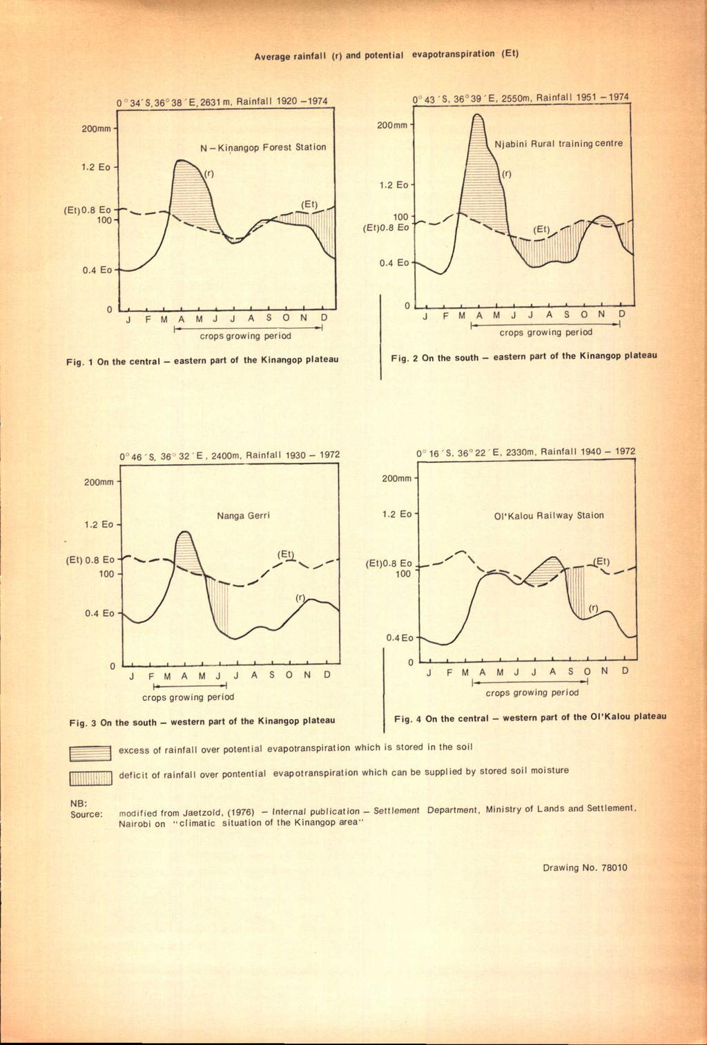
4
5

6

7
8

9
10

11

12

13

14
15

16

17

18
19
20
21

22
23

24

25

26

27

28

29

30

31

32

33
34

35
36
37

38

39
40

41

42
43

44

45

46

47
48

49

50
51

52
53

54

55
56

57

58
59
60
61

62

63
64

65
66

67

68

69

70
71
72

73

74

75

76
77 3 CL PRELIMINARY SOIL MAP OF THE KINANGOP AREA Appendix 2 to Report No.. 34*. "Soils of the.kinangop Area" O" LEGEND LPbP AD M MOUNTAINS AND MAJOR.SCARPS (slopes over 30%) MV Soil.s developed on undifferentiated volcanic rocks I MVcl I complex of well drained, shallow, to moderate I y deep, stony and very rocky soils of varying colour and texture (LITHOSOLS and mollic ANDOSOLS) I y\/c2 J complex of well drained, shallow, stony and very rocky soils of varying colour and texture (LITHOSOLS) H HILLS AND MINOR SCARPS (slopes from s-20%) HI Soils developed on trachytes [_ijiez] we " drained ' shallow, dark reddish brown, rocky clay (LITHOSOLS) HV Soils developed on undifferentiated volcanic rocks HVP J well drained, shallow to moderately deep, dark brown to black, rocky,clay loam to clay (LITHOSOLS and mollic ANDOSOLS) I \\JC I complex, of well drained to imperfectly drained, shallow to deep, rocky to extremely rocky, dark greyish brown to dark brown, firm, clay loam to clay F FOOTSLOPES (slopes from 5-16%) Fl Soils developed on colluvium derived from trachytes [ Fib moderately well drained, very deep, dark reddish brown, firm clay FP Soils developed on colluvium derived from pyroclastic rocks (tuffs) I FP1 well drained to moderately well drained, deep to very deep, very dark greyish brown to dark brown, firm clay [ FP2P I moderately well drained, shallow to moderately deep, dark brown, firm clay FV Soils developed on colluvium derived from undifferentiated volcanic rocks (vertic LUVISOLS, sodic phase) I FVr I well drained,deep to very deep, reddish brown, friable, clay to gravelly clay (ando*-ferric ACRISOLS) L DISSECTED PLATEAUS (S iopes from 2-8%), LP Soils developed on pyroclastic rocks (tuffs) [_J_P_biPj well drained, shallow, dark reddish brown, rocky, sandy clay to clay (LITHOSOLS) I well drained to moderately well drained, shallow, dark reddish. brown to very dark greyish brown, firm clay (eutric CAMBISOLS, lithic LP2P 1 vve " drained to moderately well drained, shallow to moderately deep, dark brown to dark greyish brown, phase) 1 firm clay; in places calcareous, stony and rocky (ca cjc LUVISOLS,partly lithic phase) I LPC1 j complex of: - well drained, deep to very deep, dark brown to very dark greyish brown, very friable to friable, clay loam (humic - imperfectly drained, deep, very dark greyish brown to black,firm,1 calcareous, cracking clay (calcarqîpellic I ^-P^2 j complex of: - moderately well drained, deep,'dark brown to dark greyish brown, firm, calcareous, cracking clay ANDOSOLS) VERTISOLS) TURASHA f I SETTLEMENT L -moderately well drained to imperfectly drained, deep, very dark cracking clay NON-DISSECTED PLATEAUS(siopes from o-5%) greyish brown to black, firm, calcareous, LP Soils developed on pyroclastic rocks (tuffs) LPb moderately well drained, deep, dark reddish brown' to strong brown, mottled, firm clay 1^ L P a 1 imperfectly drained t o poorly drained, deep, very dark greyish brown, mottled, friable to very firm, clay, abruptly underlying 45-55cm of silly clay loam to clay loam, with many iron-manganese concretions at transition (dysfric PLANOSOLS) I LPa2 J poorly drained, deep, very dark greyish brown to very dark grey, mottjed, very firm clay, abruptly underlying 30-4Scm of silty clay loam to clay loam, with common iron-manganese concretions at transition (dystric PLANOSOLS) llpa3 poorly drained, deep, very dark greyish brown to very dark grey, mottled, very firm clay, abruptly underlying 25-45cm of silty loam to clay loam, with many iron-manganese concretions at transition (solodic PLANOSOLS) U UPLANDS(slopes from 2-16%) UV Soils developed on undifferentiated volcanic rocks well drained, very deep, dark reddish brown to very dark greyish brown, friable clay w e H drained, moderately deep to deep, black, friable clay loam, with firm deeper subsoil (mollic A RIVER ALLUVIAL PLAINS AND TERRACES (slopes from 0-2%) ANDOSOLS) ÂÂ Soils developed on alluvium from undifferentiated volcanic rocks [_ AAJ I moderately wel I drained, very deep, dark brown to very dark greyish brown, stratified, firm, calcareous clay (calcaric FLUVISOLS) J A A 2 imperfectly drained to poorly drained, deep, very dark grey to dark greyish brown, mottled, stratified, firm, gravelly sandy clay to clay (dystric FLUVISOLS) B BOTTOMLANDS(slopes from 0-2%) BP Soils developed on alluvium/colluvium from pyroclastic rocks (tuffs) BP1 J imperfectly drained, deep, dark yellowish brown to dark greyish brown, mottled, firm, calcareous clay. (calcic CAMBISOLS) I B P 2 I imperfectly drained to poorly drained, deep, very dark grey to greyish brown, mottled, firm clay V VAL LEYS (slopes from 5-30) %) (eutric GLEYSOLS) VP Soils developed on pyroclastic rocks I VPC I complex of well drained, shallow to moderately deep, dark brown to very dark brown, friable, clay loam to clay The names between parentheses reflect the scientific soil classification according to the FAO/UNESCO legend for their "Soil Map ol the World" programme; prefixes marked with * are tentative terms, awaiting inter - national agreement on nomenclature for in intergrading soil units, KEY LPti P AD.. T5.J.. _ soil mapping symbol.depth class symbol slope class symbol > soil b 0 u n d a r y slope class boundary _ boundary of the surveyed area road motorable track river/drainage way I». dam s building (trading centre) M dairy (milk collecting centre) ;:: cattle dip minor scarp major scarp 100 ha slope 'X i 0-2 j 2-5 : ; i KEY TO SLOPE Cl ASS(; C islope class! sy rrsbo I '^ 'Q' r :r ~ name of macrorelief flat to very yently. undulaling i gently undulating undulating ; rolling i hilly > nor indicated for mountains,major scarps, hills and minor scarps KEY TO DEPTH CLASSES thickness [_ s V md0! + j I,. ~ love'"" pètro--^ name i _ s _ 011 _'_ n c m _ o v e r..: ck J/ plinthite _] j f P ~1 i shallow ; [ ' p' 1 ; ! [ ~~J m o r e t h a n ( i ~~i 120 : L - I moderately deep deep very deep il a complex of depth classes occurs in one unit, only the symbol of the shallowest depth class is indicated TEXTURAL CLASSES - * '*>,,.,., ETHIOPIA G I I H10R0 Shi TLbMtNT m / KENYA \",/ V, NAIROBI "T>M0MBASA /.location of the surveyed area percent sand SCALE 1:100,000 I RfcS 1000 ioo 0 Kija Base map compiled and simplified from Survey of Kenya topographical sheets 1:50,000 Prepared and drawn by Kenya Soil Survey in Nov Drawing No
6W9}* Appendix 2 to report No. P62 SOIL RESOURCES MAP OF TH E MPEKETONIAREA (LAMU AND TANA RIVER DISTRICTS) 40" 40 E LEGEND ISWC U8RAWY _& Jl W*g*n)ng
 40 40 E LEGEND ISWC U8RAWY _& Jl W*g*n)ng") 6W9}* Appendix 2 to report No. P62 SOIL RESOURCES MAP OF TH E MPEKETONIAREA (LAMU AND TANA RIVER DISTRICTS) 40" 40 E LEGEND ISWC U8RAWY _& Jl W*g*n)ng«ft, Tlw 9MtWt&nât COASTAL PLAINS (slopes less than
6W9}* Appendix 2 to report No. P62 SOIL RESOURCES MAP OF TH E MPEKETONIAREA (LAMU AND TANA RIVER DISTRICTS) 40" 40 E LEGEND ISWC U8RAWY _& Jl W*g*n)ng«ft, Tlw 9MtWt&nât COASTAL PLAINS (slopes less than
Classification according to patent rock material/origin, soil distribution and orders
 Classification according to patent rock material/origin, soil distribution and orders Alluvial Soils Shales and Sandstone Soils Limestone Soils Chocolate Hills: Limestone formation Andesite and Basalt
Appendix I SOIL RATING CHART. (Storie soil Index Rating = factor A* factor B* factor C* factor X) FACTOR A- Rating on character of Physical Profile
 FACTOR A- Rating on character of Physical Profile") Appendix I SOIL RATING CHART (Storie soil Index Rating = factor A* factor B* factor C* factor X) FACTOR A- Rating on character of Physical Profile Sr. No Particulars Percentage I Soil on recent alluvial
Appendix I SOIL RATING CHART (Storie soil Index Rating = factor A* factor B* factor C* factor X) FACTOR A- Rating on character of Physical Profile Sr. No Particulars Percentage I Soil on recent alluvial
LEPTOSOLS (LP) Definition of Leptosols
 Definition of Leptosols") LEPTOSOLS (LP) The Reference Soil Group of the Leptosols accommodates very shallow soils over hard rock or highly calcareous material, but also deeper soils that are extremely gravelly and/or stony. Lithosols
LEPTOSOLS (LP) The Reference Soil Group of the Leptosols accommodates very shallow soils over hard rock or highly calcareous material, but also deeper soils that are extremely gravelly and/or stony. Lithosols
Monitoring and modelling hydrological fluxes in support of nutrient cycling studies in Amazonian rain forest ecosystems Tobon-Marin, C.
 UvA-DARE (Digital Academic Repository) Monitoring and modelling hydrological fluxes in support of nutrient cycling studies in Amazonian rain forest ecosystems Tobon-Marin, C. Link to publication Citation
MAFF Ministry of IfiriLE Agriculture Fisheries and Food
 MAFF Ministry of IfiriLE Agriculture Fisheries and Food STATEMENT OF PHYSICAL CHARACTERISTICS AND AGRICULTURAL LAND CLASSIFICATION UPSLAND, KIRKLINGTON NORTH YORKSHIRE EXTRACTION OF SAND AND GRAVEL MARCH
Soil and Terrain conditions for the Upper Tana River catchment, Kenya
 Green Water Credits Report 11 Soil and Terrain conditions for the Upper Tana River catchment, Kenya Koos Dijkshoorn Peter Macharia Jan Huting Peter Maingi Christopher Njoroge (September 21) Kenya Agricultural
4. Soils and soil conditions
 4. Soils and soil conditions 4.1 General characteristics 4.1.1 Soil-forming processes Most soils of the Bardenas area show no distinct characteristics of soil development. Except in the ancient alluvium
Custom Soil Resource Report Soil Map
 77 35' 22'' W Custom Soil Resource Report Soil Map 77 35' 0'' W 282170 282220 282270 282320 282370 282420 282470 282520 282570 282620 40 59' 2'' N 40 58' 52'' N 4539900 4539950 4540000 4540050 4540100
Appendix G. Stony Creek Project
 Appendix G Water Stony Creek Project Soil and Water Information Table F1. Descriptive Statistics of Water Quality Data for Blue Ridge Ecoregion Number of Parameter Unit Minimum Maximum Median Mean Observations
MAP SHEETS 175,176,183 and 184 Appendix 1ato Report No.7"Soils and vegetation of the Tsavo area."
 MP SHEETS 175,176,183 and 184 ppendix 1ato Report No.7"Soils and vegetation of the Tsavo area." R E C O N N I S S N C E S O I L M P O F T H E M T I T O N D E I R E Ministry of griculture-kenyasonsurvey
Soil Map Boulder County Area, Colorado (Planet Blue Grass) Web Soil Survey National Cooperative Soil Survey
 Web Soil Survey National Cooperative Soil Survey") 475910 476000 476090 476180 476270 476360 105 16' 21'' W 476450 476540 476630 476720 476810 4453350 4453440 4453260 4453350 4453170 4453260 4453080 4453170 4453080 475820 475910 4452990 476000 476090 476180
475910 476000 476090 476180 476270 476360 105 16' 21'' W 476450 476540 476630 476720 476810 4453350 4453440 4453260 4453350 4453170 4453260 4453080 4453170 4453080 475820 475910 4452990 476000 476090 476180
Soil and Terrain conditions for the Upper Tana River catchment, Kenya
 Green Water Credits Report 11 b Soil and Terrain conditions for the Upper Tana River catchment, Kenya (Version 1.1) Koos Dijkshoorn Peter Macharia Jan Huting Peter Maingi Christopher Njoroge (February
Custom Soil Resource Report Soil Map
 121 3' 56'' W Custom Soil Resource Report Soil Map 121 2' 49'' W 45 16' 39'' N 5013800 5014000 5014200 5014400 5014600 5014800 5015000 5015200 5015400 5015600 651800 652000 652200 652400 652600 652800
LANDFORM ANALYSIS AND SOIL RESOURCE INVENTORY USING REMOTE SENSING TECHNIQUE IN A WATERSHED OF UTTARANCHAL, INDIA
 LANDFORM ANALYSIS AND SOIL RESOURCE INVENTORY USING REMOTE SENSING TECHNIQUE IN A WATERSHED OF UTTARANCHAL, INDIA S.K.Mahapatra *, D. Martin, R.D.Sharma, S.P. Singh and J.P.Sharma National Bureau of Soil
APPENDIX C. Ref: H-065. Copyright 2003 by Tolko High Level Lumber Division & Footner Forest Products Ltd. All Rights Reserved.
 APPENDIX C Ref: H-065 Copyright 2003 by Tolko High Level Lumber Division & Footner Forest Products Ltd. All Rights Reserved. Biophysical Description of Soils (Soil Inventory) within the FMA of Tolko Industries
Soil Map Polk County, Florida
 Soil Map Polk County, Florida 28 9' 21'' 28 8' 23'' 3113000 3113200 3113400 3113600 3113800 3114000 3114200 3114400 3114600 81 51' 19'' 81 51' 19'' 416000 416000 ± 416200 416200 68 416400 68 416400 7 13
Soil and Terrain Database for the Upper Tana, Kenya
 Soil and Terrain Database for the Upper Tana, Kenya Green Water Credits Report 11 J.A. Dijkshoorn, P.N. Macharia, J.R.M. Huting, P.M. Maingi and C.R.K. Njoroge Green Water Credits Soil and Terrain Database
Soil Factors and their Influence on Within-Field Crop Variability. I: Field Observation of Soil Variation
 Figures for: Soil Factors and their Influence on Within-Field Crop Variability I: Field Observation of Soil Variation R. Earl 1 ; J.C. Taylor 1 ; G.A. Wood 1 ; I. Bradley, I.T. James 1, T. Waine 1 ; J.P.
Standards and Procedures for Site Specific Soil Mapping in Rhode Island. Pg 1
 Standards and Procedures for Site Specific Soil Mapping in Rhode Island Pg 1 The Task Take This and Create This The Task Take This and Create This and a Report Pg 2 How is this different than the RI Soil
Teelba. Soil summary sheets. Locality and site notes. Site Details
 Teelba Soil summary sheets Locality and site notes The Teelba sites characterise soil and regolith properties in the belah/brigalow and poplar box landscapes on sandstone. Soil properties along two transects
SOIL REPORT FOR BINGARA GORGE DEVELOPMENT SITE Introduction
 SOIL REPORT FOR BINGARA GORGE DEVELOPMENT SITE Introduction On 16 March, 1 April 2016 and 21 September 2016 I undertook soil surveys at Bingara Gorge Development Site, Wilton, and prepared this soil report
Soil Types. Detailed
 Soil Science and Soil Physics Lecture 12 Soil Types Detailed Taxonomy according to FAO/UNESCO Basic soil horizons O A E B C R Plant litter at various levels of decomposition and humus - Organic matter)
Custom Soil Resource Report for Forrest County, Mississippi
 United States Department of Agriculture Natural Resources Conservation Service A product of the National Cooperative Soil Survey, a joint effort of the United States Department of Agriculture and other
DATE: 5/17/2012. LOGGED BY: Geoff Richards. COMPANY: Tetra Tech EM, Inc. DRILL FOREMAN: Walter
 ATTACHMENT 2 Page 1 of 1 B1 0 1 2 FILL, Dry; brownish red; clayey silt and gravel; ~30% gravel size fragments of dark grey microcrystalline (aphanetic), extrusive, igneous, rock 3 B1-4a 1100 B1-4b-duplicate
Soil Surveys. What are the most important properties to consider in a taxonomic system used for making a soil survey?
 Soil Surveys What are the most important properties to consider in a taxonomic system used for making a soil survey? What is a Soil Survey? Inventory of soil resources Delineation of spatial distribution
 UNIT DESCRIPTIONS: Artificial Fill, Undocumented (Afu): Locally derived sandy silt and silty sand, locally with clay and varying amounts of gravel and man-made debris. Abundant concrete rubble, in places
TEXTURE ANALYSIS. Unknown 1 Unknown 2. Unknown 3 6O 6O O Z 14X 10Z X X 8Z
 Unknown 1 Unknown 2 TEXTURE ANALYSIS Unknown 3 O 2O 10Z X X 8Z O 2X O Z 14X X 2O 6O 6O Parent Material & some of Seattle s soils ESRM 311/SEFS 507 Week 3 SOILS = f(cl, r, o, p, t) Parent Materials 1) Sedentary
ECoast Homes Pty Ltd: Proposed 76-lot subdivision, Penquite Road, Newstead GEOTECHNICAL ASSESSMENT 7 April 2009
 99 Attachment 11 (8 pages including this page) Interpretation of site geology and soils, laboratory test results, and generalised AS2870 classifications 100 Geological setting The proposed subdivision
SOIL INFORMATION FOR PUMPED WATER STORAGE SCHEME, STEELPOORT VALLEY
 REPORT On contract research for Bohlweki Environmental SOIL INFORMATION FOR PUMPED WATER STORAGE SCHEME, STEELPOORT VALLEY February 2007 By D.G. Paterson ARC-Institute for Soil, Climate and Water, Private
RANCHO de DOS PALMAS DAVIS, California, AC +/-
 RANCHO de DOS PALMAS DAVIS, California, 507.28 AC +/- Boundary Transmission Line Pond / Tank Well SCOTT STONE P: (530) 662-4094 sastone57@gmail.com 37874 County Road 28, Woodland, Ca. 95695 The information
Parent Materials. & some of Seattle s soils
 Parent Material & some of Seattle s soils ESRM 311/SEFS 507 Week 3 SOILS = f(cl, r, o, p, t) Parent Materials 1) Sedentary a) residual (bedrock weathered in place) b) organic 2) Transported by a) gravity
ANDOSOLS and ARENOSOLS
 ANDOSOLS and ARENOSOLS Otto Spaargaren ISRIC World Soil Information Wageningen The Netherlands Definition of Andosols (WRB 2001) Soils having 1. an andic or a vitric horizon starting within 25 cm from
Appendix F Geotechnical Investigation
 Appendix F Geotechnical Investigation Cie Sucriere de Bel Ombre Ltee Residential Development at Bel Ombre Environmental Impact Assessment F1 Geotechnical Investigation This appendix includes the Factual
coosi 3^COMMONWEALTH OP AUSTRALIA
 1940 coosi 3^COMMONWEALTH OP AUSTRALIA DEPARTMENT OF NATIONAL DEVELOPMENT BUREAU OF MINERAL RESOURCES GEOLOGY AND GEOPHYSICS RECORDS: $966/54 019564 REPORT ON PHOTO INTERPRETATION OF MILLUNGERA 1:250,000
STANDARDIZED DATABASE OF LAND EVALUATION FOR AGRICULTURAL PRODUCTION
 STANDARDIZED DATABASE OF LAND EVALUATION FOR AGRICULTURAL PRODUCTION Nguyen Xuan Hai, Pham Thi Ha Nhung, Nguyen Quoc Viet VNU University of Sciences, Nguyen Trai, Hanoi, Vietnam E-Mail: nguyenxuanhai@hus.edu.vn
The Soils and Land Capability for Agriculture. Land North of Aberdeen, Aberdeenshire
 The Soils and Land Capability for Agriculture Of Land North of Aberdeen, Aberdeenshire Report prepared for Peter Radmall Associates May 2012 Reading Agricultural Consultants Ltd Beechwood Court, Long Toll,
On-Site Soils Investigation. Buttermilk Way Storm water Treatment Project Buzzards Bay. MA. February 28 th, 2012
 1 On-Site Soils Investigation Buttermilk Way Storm water Treatment Project Buzzards Bay. MA February 28 th, 2012 Glenn Stanisewski, Resource Soil Scientist, USDA-NRCS, West Wareham, MA Introduction: The
Key Reference Site 12
 Key Reference Site 12 Site details MGA Coordinates: 661374 me 7457821 mn Zone 55 Lat/long: -22.98007 S 148.57429 E Primary site: SALTC 349 Geology: Cz - Undifferentiated Cainozoic sediments (colluvial
Custom Soil Resource Report for Clackamas County Area, Oregon
 United States Department of Agriculture Natural Resources Conservation Service A product of the National Cooperative Soil Survey, a joint effort of the United States Department of Agriculture and other
Custom Soil Resource Report. Soil Map. Map projection: Web Mercator Corner coordinates: WGS84 Edge tics: UTM Zone 14N WGS84. Feet.
 Custom Soil Resource Report Soil Map 3188500 3188700 3188900 3189100 3189300 3189500 3189700 96 43' 30'' W 3188500 3188700 3188900 3189100 3189300 3189500 3189700 96 42' 11'' W 28 48' 59'' N 28 48' 59''
SOILS RELATIVE TO GEOLOGY AND LANDFORMS IN WALNUT GULCH EXPERIMENTAL WATERSHED, ARIZONA, USA. W. R. Osterkamp, D. J. Breckenfeld, and J.J.
 SOILS RELATIVE TO GEOLOGY AND LANDFORMS IN WALNUT GULCH EXPERIMENTAL WATERSHED, ARIZONA, USA W. R. Osterkamp, D. J. Breckenfeld, and J.J. Stone ABSTRACT Soils of the Walnut Gulch Experimental Watershed
3.10 GEOLOGY AND SOILS
 3.10 GEOLOGY AND SOILS This section evaluates the potential impacts of the proposed project on geology, soils, and seismic hazards. This evaluation is based on the Preliminary Geotechnical Investigation
 Photo 1 - Southerly view across 2700 parking lot toward existing building. Multi-residential building borders western side of property in upper right of view. Photo 2 - Southerly view across 2750 parking
Custom Soil Resource Report for Polk County, Oregon
 United States Department of Agriculture Natural Resources Conservation Service A product of the National Cooperative Soil Survey, a joint effort of the United States Department of Agriculture and other
CRUM RANCH AREA MAP YOLO COUNTY, California, AC +/-
 CRUM RANCH AREA MAP YOLO COUNTY, California, 235.59 AC +/- Map data 2016 Google Imagery 2016, CAPCOG, DigitalGlobe, Texas Orthoimagery Program, U.S. Geological Survey, USDA Farm Service Agency Boundary
Relationships between soils and elevation along toposequence in east Cache valley
 Term project for GIS in Water Resources CEE Relationships between soils and elevation along toposequence in east Cache valley Introduction By Hiroaki Shimada Soils have important roles in ecosystem. The
Custom Soil Resource Report for Valley County, Montana
 United States Department of Agriculture Natural Resources Conservation Service A product of the National Cooperative Soil Survey, a joint effort of the United States Department of Agriculture and other
Assistance with magnetic susceptibility measurements Soil samples from the archive of the Agropedology Institute, Sarajevo.
 Assistance with magnetic susceptibility measurements Soil samples from the archive of the Agropedology Institute, Sarajevo. Jacqueline Hannam & Pat Bellamy Report for Institute for the Protection and Security
Custom Soil Resource Report for Victoria County, Texas
 United States Department of Agriculture Natural Resources Conservation Service A product of the National Cooperative Soil Survey, a joint effort of the United States Department of Agriculture and other
BURIED SOILS OF GLOBE HILL, UPPER OHIO VALLEY
 BURIED SOILS OF GLOBE HILL, UPPER OHIO VALLEY HEBER D. LESSIG Soil Scientist, Box 248, Lisbon, Ohio A terrace, 5 mi downstream from Wellsville, Ohio, standing about 200 ft above the Ohio River, was recently
A framework for the 1:1,000,000 soil database of China
 Symposium no. 62 Paper no. 1757 Presentation: poster A framework for the 1:1,000,000 soil database of China SHI X.Z. (1), YU D.S. (1), PAN X.Z. (1), SUN W.X. (1), GONG Z.G. (1), Warner E.D. (2) and Petersen
SOILS OF THE HIGH TERRACE REMNANTS IN THE UPPER OHIO VALLEY
 SOILS OF THE HIGH TERRACE REMNANTS IN THE UPPER OHIO VALLEY HEBER D. LESSIG Soil Conservation Service, U. S. Department of Agriculture, Box 248, Lisbon, Ohio INTRODUCTION Soils on the high terrace remnants
SOIL PROFILE STUDY GUIDE
 2017 USDA, Natural Resources Conservation Service Yuri Plowden Ecological Site Specialist SOIL PROFILE STUDY GUIDE The purpose of this study guide is to help familiarize you with different characteristics
DETERMINING SOIL PATTERNS IN SINGLETON TRAINING AREA NOT IDENTIFIED BY GEOLOGY AND CATENARY POSITION
 DETERMINING SOIL PATTERNS IN SINGLETON TRAINING AREA NOT IDENTIFIED BY GEOLOGY AND CATENARY POSITION Robert Gourlay and Brian Tunstall 1994 ABSTRACT A prior soil survey of the Singleton Training Area identified
Custom Soil Resource Report for Clackamas County Area, Oregon
 United States Department of Agriculture Natural Resources Conservation Service A product of the National Cooperative Soil Survey, a joint effort of the United States Department of Agriculture and other
G470/570 Regional Landscapes of Oregon Basics of Soils and Rock Weathering
 G470/570 Regional Landscapes of Oregon Basics of Soils and Rock Weathering I. SOIL BASICS A. Soils Defined 1. Soils represent the weathered mantle of unconsolidated surficial material that covers land
Precision Soil Map for Future Vineyards 55 Acre Site
 Precision Soil Map for Future Vineyards 55 Acre Site Rockyford Road Yamhill County, Oregon For: Mike Long June 16, 2008 By Andy Gallagher Soil Scientist INTRODUCTION AND BACKGROUND Soil diversity and soil
Evaluation/Monitoring Report No. 259
 SITE 100M EAST OF 16 LEARMORE ROAD CASTLEGORE CASTLEDERG COUNTY TYRONE LICENCE NO.: AE/13/36E NAOMI CARVER 1 Site Specific Information Site Name: 100m east of 16 Learmore Road, Castlederg, Co. Tyrone Townland:
Custom Soil Resource Report for Multnomah County Area, Oregon
 United States Department of Agriculture Natural Resources Conservation Service A product of the National Cooperative Soil Survey, a joint effort of the United States Department of Agriculture and other
Dashed line indicates the approximate upper limit boundary for natural soils. C L o r O L C H o r O H
 SYMBOL SOURCE 8 9 1 SOIL DATA NATURAL SAMPLE DEPTH WATER PLASTIC LIQUID PLASTICITY NO. CONTENT LIMIT LIMIT INDEX (%) (%) (%) (%) Client: County of Berthoud Project: Project No.: Boring B-2 S-1-5' 6.2 8
RECONNAISSANCE SOIL MAP OF THE MTITO ANDEI AREA
 MP SHEETS 75,76,83 and 84 ppendix 2ato Report No.7'Soils and vegetation of the Tsavo area." RECONNSSNCE SOL MP OF THE MTTO NDE RE Ministry of griculture -KenyaSoilSurvey Ministry of Tourism and Wildlife-Tsavo
HEBER D. LESSIG U.S. Soil Conservation Service, Box 248, Lisbon, Ohio
 THE SOILS DEVELOPED ON WISCONSIN AND ILLINOIAN- AGE GLACIAL OUTWASH TERRACES ALONG LITTLE BEAVER CREEK AND THE ADJOINING UPPER OHIO VALLEY, COLUMBIANA COUNTY, OHIO HEBER D. LESSIG U.S. Soil Conservation
Appendix A. Producer Statement Advisory Note
 Appendix A Producer Statement Advisory Note Ref. No. 17095 26 May 2017 PRODUCER STATEMENT CONSTRUCTION REVIEW (PS4) IMPORTANT ADVISORY NOTE The Building Consent Authority (BCA) frequently requires Producer
Custom Soil Resource Report for Bucks County, Pennsylvania
 United States Department of Agriculture Natural Resources Conservation Service A product of the National Cooperative Soil Survey, a joint effort of the United States Department of Agriculture and other
Using the Web Soil Survey Resilience and Resistance Score Sheet Soils Report
 Using the Resilience and Resistance Score Sheet Soils Report 1. Go to http://websoilsurvey.nrcs.usda.gov/app/ and click on the Start WSS button. 2. Create an Area of Interest (AOI) using any of the available
The first step is accomplished by weathering (disintegration & decomposition) The second step is associated with the action of Soil Forming Factors
 The second step is associated with the action of Soil Forming Factors") Soil formation factors The soil formation is the process of two consecutive stages. 1. The weathering of rock (R) into Regolith 2. The formation of true soil from Regolith The evolution of true soil from
Soil formation factors The soil formation is the process of two consecutive stages. 1. The weathering of rock (R) into Regolith 2. The formation of true soil from Regolith The evolution of true soil from
Appendix 4 Detailed Terrain Analysis Report
 Appendix 4 Detailed Terrain Analysis Report Helliwell Provincial Park Ecosystem Based Plan March 2001 Terrain Mapping Introduction Helliwell Park is located on the eastern peninsula of Hornby Island, British
LEGEND BUSINESS ZONE NORTH OF AGRESEARCH BOREHOLE CPT SEISMIC CPT AUGER SCALE. Powells Road TEST PIT AGRESEARCH INNOVATION PARK. Hamilton Ring Road
 LEGEND ra R aku Ru BUSINESS ZONE NORTH OF Powells Road oad AGRESEARCH BOREHOLE CPT SEISMIC CPT AUGER SCALE 3 mm TEST PIT AS121 SCPT12 TP18 BH13 TP15 2 AS125 AS126 TP14 BH12 AGRESEARCH CPT13 TP17 INNOVATION
Maggie Payne Jim Turenne
 Maggie Payne Jim Turenne USDA-NRCS 60 Quaker Lane, Suite 46 Warwick, RI. 02886 401-822-8832 maggie.payne@ri.usda.gov U.S. Department of Agriculture 1935: Soil Conservation Service (SCS) Natural Resources
STATEMENT OF PHYSICAL CHARACTERISTICS REPORT FOR WELLINGTON, HEREFORD AND WORCESTER MINERALS LOCAL PLAN
 STATEMENT OF PHYSICAL CHARACTERISTICS REPORT FOR WELLINGTON, HEREFORD AND WORCESTER MINERALS LOCAL PLAN M J Wood ADAS Ref: 25/RPT/0039 Resource Planning Team Job No: 164/94 ADAS Statutory Group MAFF Ref:
Exhibit RMP-4. Foote Creek Geology and Topography
 Exhibit RMP-4 Foote Creek Geology and Topography Memorandum To: From: CC: Travis Brown, PacifiCorp Daria Drago, P.E., PMP Dr. Deb Luchsinger Date: January 9, 2019 Re: Foote Creek Rim 1 - Geologic Conditions
Custom Soil Resource Report for Clackamas County Area, Oregon, and Marion County Area, Oregon
 United States Department of Agriculture Natural Resources Conservation Service A product of the National Cooperative Soil Survey, a joint effort of the United States Department of Agriculture and other
Weathering, Erosion and Deposition
 Weathering, Erosion and Deposition Shaping the Earth s Surface Weathering the process of breaking down rocks into smaller fragments Erosion the transport of rock fragments from one location to another
Figure 45. Plan of Pukaroro drawn from aerial photograph. K. Jones, drawn by C. Edkins, DOC.
 Figure 45. Plan of Pukaroro drawn from aerial photograph. K. Jones, drawn by C. Edkins, DOC. 101 length, and there are cross-rows forming semi-enclosures. House floors are also present at the southern
KANSAS GEOLOGICAL SURVEY Open File Report LAND SUBSIDENCE KIOWA COUNTY, KANSAS. May 2, 2007
 KANSAS GEOLOGICAL SURVEY Open File Report 2007-22 LAND SUBSIDENCE KIOWA COUNTY, KANSAS Prepared by Michael T. Dealy L.G., Manager, Wichita Operations SITE LOCATION The site was approximately four miles
Collfryn Ring-ditch, Guilsfield, Powys
 CPAT Report No 1122 TRIAL EXCAVATION 2011 THE CLWYD-POWYS ARCHAEOLOGICAL TRUST CPAT Report No 1122 TRIAL EXCAVATION 2011 I Grant December 2011 Report for Cadw The Clwyd-Powys Archaeological Trust 41 Broad
The potential of GIS in mapping soil health. Tim Brewer 19/11/2104
 The potential of GIS in mapping soil health Tim Brewer 19/11/2104 Horizon Depth (cm) Sand % Silt % Clay % ph Organic Carbon (wt%) Bulk Density (g/cm3) Particle Density (g/cm3) Total Porosity (%) Water
Soils of the GLBRC Marginal Land Experiment (MLE) Sites
 Sites") KBS LTER Special Publication Soils of the GLBR Marginal Land Experiment (MLE) Sites. S. Kasmerchak and R. Schaetzl Department of Geography, Environmental, and Spatial Sciences Michigan State University
KBS LTER Special Publication Soils of the GLBR Marginal Land Experiment (MLE) Sites. S. Kasmerchak and R. Schaetzl Department of Geography, Environmental, and Spatial Sciences Michigan State University
Weathering is the process that breaks down rock and other substances at Earth s surface
 Chapter 8 Notes Weathering is the process that breaks down rock and other substances at Earth s surface Factors that contribute to weathering Heat Cold Water Ice O 2 & CO 2 in the atmosphere Examples of
Characteristics and processes associated with the development of Hilly Landscapes
 GRADE 11 GEOGRAPHY SESSION 1: GEOMORPHOLOGY I (TOPOGRAPHY) Key Concepts In this lesson we will focus on summarising what you need to know about: Topography associated with Horizontally Layered Rocks Topography
Lowest and Youngest Terrace : Soil Pit #4
 Lowest and Youngest Terrace : Soil Pit #4 Observations : Where : Huntington Terraces Climate : Cloudy, mid 60 s Our soil pit was the lowest of the 4 sites The pit site was located on the right side of
16 January 2018 Job Number: RICHARD NEWMAN C\- CLARK FORTUNE MCDONALD AND ASSOCIATES PO BOX 553 QUEENSTOWN
 16 January 2018 Job Number: 50595 RICHARD NEWMAN C\- CLARK FORTUNE MCDONALD AND ASSOCIATES PO BOX 553 QUEENSTOWN CHANSEN@CFMA.CO.NZ STORMWATER DISPOSAL ASSESSMENT Dear Richard, RDAgritech were requested
Spatial Variation of Soil Type and Soil Moisture in the Regional Atmospheric Modeling System (U)
") WSRC-TR-2001-00119 (U) Spatial Variation of Soil Type and Soil Moisture in the Regional Atmospheric Modeling System (U) Robert L. Buckley Savannah River Technology Center Publication Date: Westinghouse
WSRC-TR-2001-00119 (U) Spatial Variation of Soil Type and Soil Moisture in the Regional Atmospheric Modeling System (U) Robert L. Buckley Savannah River Technology Center Publication Date: Westinghouse
Key Reference Site 7. Site details. Climate 5. Queensland Key Reference Sites. Site location. Soil and landscape correlation. June 2006 QKRS 7-1
 Key Reference Site 7 Site details MGA Coordinates: 615229 me 7363243 mn Zone 55 Lat/long: -23.83805 S 148.13144 E Primary site: SALTC 342 Geology: PII - Alderabaran Sandstone /shale (Permian), Back Creek
 TP-1 N61E 0 DARK BROWN SANDY SILT (ML) stiff, wet with roots (Disturbed Surficial Soil) DEPTH (FEET) 5 REDDISH BROWN SANDSTONE intensely fractured, weak to friable, deeply weathered, tight (Franciscan
We recommend you cite the published version. The publisher s URL is
 Bridle, A. (2012) The mid-to-late pleistocene palaeos of the Gordano Valley, North Somerset. PhD, University of the West of England. We recommend you cite the published version. The publisher s URL is
Soils of the Lake Naivasha Area, Kenya
 INTERNATIONONAL INSTITUTE FOR AEROSPACE.SURVEY AND EARTH SCIENCES Soils of the Lake Naivasha Area, Kenya Summary of investigations 1997-2000 by the Soil Science Division, International Institute for Aerospace
INTERNATIONAL JOURNAL OF GEOMATICS AND GEOSCIENCES Volume 5, No 2, 2014
 INTERNATIONAL JOURNAL OF GEOMATICS AND GEOSCIENCES Volume 5, No 2, 2014 Copyright by the authors - Licensee IPA- Under Creative Commons license 3.0 Research article ISSN 0976 4380 Integration of high resolution
CRITERIA FOR DEFINING THE SERIES (DAR, 2006)
") CRITERIA FOR DEFINING THE SERIES (DAR, 2006) On the Soils Map of Catalonia (1:25 000), the soil series are defined on the basis of the following hierarchically organised criteria. Classification at the
CRITERIA FOR DEFINING THE SERIES (DAR, 2006) On the Soils Map of Catalonia (1:25 000), the soil series are defined on the basis of the following hierarchically organised criteria. Classification at the
README: LIQUEFACTION SUSCEPTIBILITY MAP OF TETON COUNTY, IDAHO. William M. Phillips Digital Database 6
 WHAT IS LIQUEFACTION? README: LIQUEFACTION SUSCEPTIBILITY MAP OF TETON COUNTY, IDAHO William M. Phillips Digital Database 6 Idaho Geological Survey PO Box 443014 University of Idaho Moscow, ID 83844 3014
DATING AND SOIL ORGANIC MATTER DYNAMICS IN ARCTIC AND SUBARCTIC ECOSYSTEMS
 [RADIOCARBON, VOL. 38, No. 2,19%, P. 241-245] 14C DATING AND SOIL ORGANIC MATTER DYNAMICS IN ARCTIC AND SUBARCTIC ECOSYSTEMS A. E. CHERKINSKY Krueger Enterprises, Inc., Geochron Laboratories Division,
Site 3: Park Road, Katikati: field logs, stratigraphic description, and site description
 Appendix 4.2 Site 3: Park Road, Katikati: field logs, stratigraphic description, and site description Criteria suitability The third site selected was at Park Road Reserve, Katikati (Figure 1). This site
Soils of Rhode Island
 Soils of Rhode Island Jim Turenne, RI State Soil Scientist USDA-NRCS 60 Quaker Ln. Suite 46 Warwick, RI. 02886 401-822-8830 http://nesoil.com Jim.turenne@ri.usda.gov About NRCS Established as the Soil
DRENNAN MAUD (PTY) LTD
 LTD") DRENNAN MAUD (PTY) LTD GEOTECHNICAL ENGINEERS AND ENGINEERING GEOLOGISTS Incorporating Drennan Maud & Partners (Est.1975) and GAP Consulting Reg. No. 2014/038872/07 Durban Head Office Info@drennanmaud.com
DRENNAN MAUD (PTY) LTD GEOTECHNICAL ENGINEERS AND ENGINEERING GEOLOGISTS Incorporating Drennan Maud & Partners (Est.1975) and GAP Consulting Reg. No. 2014/038872/07 Durban Head Office Info@drennanmaud.com
5 th INTERNATIONAL SOIL CLASSIFICATION CONGRESS December 2016, South Africa
 Report 5 th INTERNATIONAL SOIL CLASSIFICATION CONGRESS 2016 1 7 December 2016, South Africa Biol. Silvia Chávez Castellanos Last month, from 1 st to the 7 th of December took place the 5th International
PHYSICAL GEOGRAPHY. By Brett Lucas
 PHYSICAL GEOGRAPHY By Brett Lucas SOILS Soils Soil and Regolith Soil-Forming Factors Soil Components Soil Properties Soil Chemistry Soil Profiles Pedogenic Regimes Global Distribution of Soils Distribution
DATA REPORT GEOTECHNICAL INVESTIGATION GALVESTON CRUISE TERMINAL 2 GALVESTON, TEXAS
 DATA REPORT GEOTECHNICAL INVESTIGATION GALVESTON CRUISE TERMINAL 2 GALVESTON, TEXAS SUBMITTED TO PORT OF GALVESTON 123 ROSENBERG AVENUE, 8TH FLOOR GALVESTON, TEXAS 77553 BY HVJ ASSOCIATES, INC. HOUSTON,
Custom Soil Resource Report for Polk County, Oregon
 United States Department of Agriculture Natural Resources Conservation Service A product of the National Cooperative Soil Survey, a joint effort of the United States Department of Agriculture and other
Custom Soil Resource Report for St. Lucie County, Florida
 United States Department of Agriculture Natural Resources Conservation Service A product of the National Cooperative Soil Survey, a joint effort of the United States Department of Agriculture and other