CRP HEL CRP Ortho Imagery. Tract Cropland Total: acres
|
|
|
- Sheena Whitehead
- 6 years ago
- Views:
Transcription


1 United States Department of Agriculture Madison County, Iowa TH LN T ELMWOOD AVE T ² Common Land Unit Non-Cropland Cropland Wetland Determination Identifiers #*&- Restricted Use Limited Restrictions Tract Boundary PLSS , Ortho Imagery Feet Tract Cropland Total: acres 2017 Program Year Map Created December 01, 2016 Farm 1672 Tract 347 Exempt from ") Compliance Provisions United States Department of Agriculture (USDA) Farm Service Agency (FSA) maps are for FSA Program administration only. This map does not represent a legal survey or reflect actual ownership; rather it depicts the information provided directly from the producer and/or National Agricultural Imagery Program (NAIP) imagery. The producer accepts the data 'as is' and assumes all risks associated with its use. USDA-FSA assumes no responsibility for actual or consequential damage incurred as a result of any user's reliance on this data outside FSA Programs. Wetland identifiers do not represent the size, shape, or specific determination of the area. Refer to your original determination (CPA-026 and attached maps) for exact boundaries and determinations or contact USDA Natural Resources Service (NRCS).
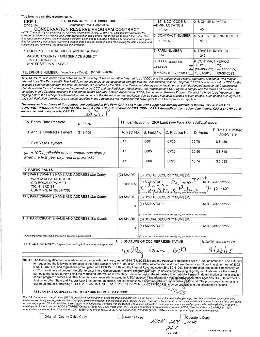
2
3
4 IOWA MADISON Form: FSA-156EZ See Page 2 for non-discriminatory Statements. United States Department of Agriculture Farm Service Agency Abbreviated 156 Farm Record FARM : Prepared : Crop Year : 1672 Jul 5, Operator Name : Farms Associated with Operator : Contract Number(s) : SCHULZ FARMS INC , , , , , , , , , , A Farm Land Data Farmland Cropland DCP Cropland WBP WRP GRP Sugarcane Farm Status Number Of Tracts Active 1 State Other Effective DCP Cropland Double Cropped MPL Acre Election EWP DCP Ag. Related Activity No Crop Election Choice ARC Individual ARC County Price Loss Coverage None CORN None DCP Crop Data Crop Name Base Acres CCC-505 Reduction Acres CTAP Yield PLC Yield HIP Oats Corn TOTAL NOTES Tract Number : Description : BIA Unit Range Number : Status : Wetland Status : WL Violations : Owners : Other Producers : 347 2, 3 field on tract. system being actively applied Tract does not contain a wetland None WANDA M PALMER TRUST DAVID M ROBINSON, RONALD PALMER Tract Land Data Farm Land Cropland DCP Cropland WBP WRP GRP Sugarcane State Other Effective DCP Cropland Double Cropped MPL EWP DCP Ag. Related Activity DCP Crop Data Crop Name Base Acres CCC-505 Reduction Acres CTAP Yield PLC Yield Oats Corn TOTAL NOTES Page: 1 of 2

5 IOWA MADISON Form: FSA-156EZ United States Department of Agriculture Farm Service Agency Abbreviated 156 Farm Record FARM : Prepared : Crop Year : 1672 Jul 5, The U.S. Department of Agriculture (USDA) prohibits discrimination against its customers, employees, and applicants for employment on the basis of race, color, national origin, age, disability, sex, gender identity, religion, reprisal, and where applicable, political beliefs, marital status, familial or parental status, sexual orientation, or all or part of an individual's income is derived from any public assistance program, or protected genetic information in employment or in any program or activity conducted or funded by the Department. (Not all prohibited bases will apply to all programs and/or employment activities.) Persons with disabilities, who wish to file a program complaint, write to the address below or if you require alternative means of communication for program information (e.g., Braille, large print, audiotape, etc.) please contact USDA's TARGET Center at (202) (voice and TDD). Individuals who are deaf, hard of hearing, or have speech disabilities and wish to file either an EEO or program complaint, please contact USDA through the Federal Relay Service at (800) or (800) (in Spanish). If you wish to file a Civil Rights program complaint of discrimination, complete the USDA Program Discrimination Complaint Form, found online at or at any USDA office, or call (866) to request the form. You may also write a letter containing all of the information requested in the form. Send your completed complaint form or letter by mail to U.S. Department of Agriculture, Director, Office of Adjudication, 1400 Independence Avenue, S.W., Washington, D.C , by fax (202) or at program.intake@usda.gov. USDA is an equal opportunity provider and employer. Page: 2 of 2
Abbreviated 156 Farm Record
 MISSOURI HOWARD Form: FSA-156EZ See Page 3 for non-discriminatory Statements. United States Department of Agriculture Farm Service Agency Abbreviated 156 Farm Record FARM : Prepared : Crop Year : 4825
MATHEWS FARM TUNICA MISSISSIPPI 1130 ACRES (+/ ) TUNICA AND DESOTO COUNTY FOR SALE. List Price $6,100,000.
 TUNICA AND DESOTO COUNTY FOR SALE. List Price $6,100,000.") MATHEWS FARM TUNICA MISSISSIPPI 1130 ACRES (+/ ) TUNICA AND DESOTO COUNTY FOR SALE List Price $6,100,000. FARM ACREAGE BREAKDOWN: Map Acres FSA Crop Acres Shop, bins, turn rows, and ditches Tract 1 Main
MATHEWS FARM TUNICA MISSISSIPPI 1130 ACRES (+/ ) TUNICA AND DESOTO COUNTY FOR SALE List Price $6,100,000. FARM ACREAGE BREAKDOWN: Map Acres FSA Crop Acres Shop, bins, turn rows, and ditches Tract 1 Main
YELLOW MEDICINE COUNTY FARMS FOR SALE
 YELLOW MEDICINE COUNTY FARMS FOR SALE Owners Rhea Trusts 790+ acres of high quality cropland in western Yellow Medicine County, MN. The land has been owned by the Rhea family for many years. The land includes
160 Acres of Tillable Land, Alfalfa, Pasture, Building Site, and Rec Area in Sun Prairie Township! Thursday, November 1, 2018 at NOON
 160+/- Acres of McCook County land 160 Acres of Tillable Land, Alfalfa, Pasture, Building Site, and Rec Area in Sun Prairie Township! Thursday, November 1, 2018 at NOON Located from Salem, SD on US HWY
Total Acres: Tillable Acres: Irrigated Acres: All Improvements will be managed by Farmers National Company / CHS.
 GROUP P Parcel # Acres Twp County FSA Farm FSA Tract Tillable Acres Irrigated Acres 14-040-011-022-00 105.00 Lagrange Cass 7797 7858 262.12 72.50 14-040-011-022-10 5.00 Lagrange Cass 7797 7858 w 040-011-022-00
Near Sledge, Mississippi. Please call to arrange a private viewing
 $3,958,000.00 $1,685,000 ($4,010/Acre) ($3,539/Acre) Precision Leveled Cropland 936.7 Total Acres - 598.39 Cropland Acres - 32.54 CRP Acres - 252.7 Timberland Acres (5) Irrigation Wells CRP Income: $6,500
105 (+/-) acres Jefferson County, Arkansas
 acres Jefferson County, Arkansas") offered for sale THE PB 105 A recreational and agricultural investment opportunity. 105 (+/-) acres Jefferson County, Arkansas offered by Licensed in Arkansas, Louisiana, Mississippi, Tennessee and Texas
offered for sale THE PB 105 A recreational and agricultural investment opportunity. 105 (+/-) acres Jefferson County, Arkansas offered by Licensed in Arkansas, Louisiana, Mississippi, Tennessee and Texas
BROWN COUNTY FARMLAND AUCTION
 BROWN COUNTY FARMLAND AUCTION CROP - PASTURE - HUNTING - INVESTMENT 62 Acres +/- TUESDAY, NOVEMBER, 1 :30am Auction Location: The DEC (Dakota Event Center) - Lamont St. - Aberdeen, SD 5401 Mercier & Ravina
What is a published soil survey?
 What is a published soil survey? A soil survey is a detailed report on the soils of an area. The soil survey has maps with soil boundaries and photos, descriptions, and tables of soil properties and features.
Management and Use of LiDAR-derived Information. Elizabeth Cook, GIS Specialist
 Management and Use of LiDAR-derived Information Elizabeth Cook, GIS Specialist Advanced LiDAR Workshop March 15, 2012 50-100 gb/county Now What? Project Deliverables LAS mass point files, classification
PRELIMINARY INFORMATION BOOKLET. Texas TOTAL OF 45,538± ACRES INCLUDING COLORADO, NEBRASKA & ILLINOIS
 OWNERS WILL ENTERTAIN NON-CONTINGENT OFFERS ON PORTFOLIO, BY COUNTY, UNTIL OCTOBER 13. PRELIMINARY INFORMATION BOOKLET Texas TOTAL OF 45,538± ACRES INCLUDING COLORADO, NEBRASKA & ILLINOIS DISCLAIMER: This
Crop Progress. Corn Mature Selected States [These 18 States planted 92% of the 2017 corn acreage]
![Crop Progress. Corn Mature Selected States [These 18 States planted 92% of the 2017 corn acreage]](/thumbs/89/98128758.jpg "Crop Progress. Corn Mature Selected States [These 18 States planted 92% of the 2017 corn acreage]") Crop Progress ISSN: 00 Released October, 0, by the National Agricultural Statistics Service (NASS), Agricultural Statistics Board, United s Department of Agriculture (USDA). Corn Mature Selected s [These
Crop Progress ISSN: 00 Released October, 0, by the National Agricultural Statistics Service (NASS), Agricultural Statistics Board, United s Department of Agriculture (USDA). Corn Mature Selected s [These
² 2015 Program Year. Farm Tract McLeod County, Minnesota 1:4, NHEL NHEL
 United States Department of Agriculture McLeod County, Minnesota Farm 5125 #* 2 3.65 NHEL Tract 2762 1 33.19 NHEL ² 2015 Program Year Map Created November 06, 2014 Common Land Unit Cropland Non-cropland
The Wildland Fire Chemical
 United States Department of Agriculture Forest Service Technology & Development Program Airtanker 157-284-MTDC January 21 51/57 Drop Guides Ground Pattern Performance of the National Guard Black Hawk Helicopter
Soils of Hawai i Dr. Greg Bruland NREM 461
 Soils of Hawai i Dr. Greg Bruland NREM 461 Figure modified from Gavenda et al. 1998 Island Age = million years (mya) Map modified from Gavenda et al. 1998 Island Age = mya 9 of 11 soil orders present Map
Airtanker. Drop Guides
 United States Department of Agriculture Forest Service Technology & Development Program Airtanker 57-2852-MTDC September 2 51/57 Drop Guides Ground Pattern Performance of the Snow Air Tractor with Constant
Custom Soil Resource Report for Clackamas County Area, Oregon
 United States Department of Agriculture Natural Resources Conservation Service A product of the National Cooperative Soil Survey, a joint effort of the United States Department of Agriculture and other
Custom Soil Resource Report for Multnomah County Area, Oregon
 United States Department of Agriculture Natural Resources Conservation Service A product of the National Cooperative Soil Survey, a joint effort of the United States Department of Agriculture and other
i~ ~~r.~~y' FSA Aerial Map Tract 1: Acres: 160 +/EII2NEI/4 of Section 25, To P.M., North, Range 56 West of the 5t
 FSA Aerial Map 160 +/E2E/4 of Section 25, To orth, Range 56 West of the 5t, South Dakot SE1/4W14 of Section 30, To 126 orth, Range 55 West oft P.M.,, South map center: 45 42' 1.15, 97 28' 57.63 scale:
Custom Soil Resource Report for Clackamas County Area, Oregon
 United States Department of Agriculture Natural Resources Conservation Service A product of the National Cooperative Soil Survey, a joint effort of the United States Department of Agriculture and other
Commentary on Factors Affecting Transverse Vibration Using an Idealized Theoretical Equation
 United States Department of Agriculture Forest Service Forest Products Laboratory Research Note FPL RN 076 Commentary on Factors Affecting Transverse Vibration Using an Idealized Theoretical Equation Joseph
Custom Soil Resource Report for Valley County, Montana
 United States Department of Agriculture Natural Resources Conservation Service A product of the National Cooperative Soil Survey, a joint effort of the United States Department of Agriculture and other
Equal Employment Opportunity Data Posted Pursuant to the No FEAR Act
 Page 1 of 7 U. S. Postal Service Equal Employment Opportunity Data Posted Pursuant to Title III of the Notification and Federal Employee Antidiscrimination and Retaliation Act of 2002 (No FEAR Act), Public
Equal Employment Opportunity Data Posted Pursuant to the No FEAR Act
 Page 1 of 7 Eastern Area U. S. Postal Service Equal Employment Opportunity Data Posted Pursuant to Title III of the Notification and Federal Employee Antidiscrimination and Retaliation Act of 2002 (No
The New York City Soil Survey
 The New York City Soil Survey Olga Vargas, USDA-NRCS Soil Scientist May 2018 New York City Soil Survey Program Since 1995 A partnership was established between: NRCS NYC-SWCD Cornell University To address
Equal Employment Opportunity Data Posted Pursuant to the No Fear Act: Army (and below)
") Equal Employment Opportunity Data Posted Pursuant to the No Fear Act: Army (and below) For 4th Quarter 2013 for period ending September, 2013 **This report is based on the Complaint Against hierarchy.**
Equal Employment Opportunity Data Posted Pursuant to the No Fear Act: Army (and below) For 4th Quarter 2013 for period ending September, 2013 **This report is based on the Complaint Against hierarchy.**
U. S. Postal Service
 U. S. Postal Service Equal Employment Opportunity Data Posted Pursuant to Title III of the Notification and Federal Employee Antidiscrimination and Retaliation Act of 2002 (No FEAR Act), Public Law 107-174
Capital Metro Area U. S. Postal Service
 Capital Metro Area U. S. Postal Service Equal Employment Opportunity Data Posted Pursuant to Title III of the Notification and Federal Employee Antidiscrimination and Retaliation Act of 2002 (No FEAR Act),
Pacific Area U. S. Postal Service
 Pacific Area U. S. Postal Service Equal Employment Opportunity Data Posted Pursuant to Title III of the Notification and Federal Employee Antidiscrimination and Retaliation Act of 2002 (No FEAR Act), Public
Western Area U. S. Postal Service
 Western Area U. S. Postal Service Equal Employment Opportunity Data Posted Pursuant to Title III of the Notification and Federal Employee Antidiscrimination and Retaliation Act of 2002 (No FEAR Act), Public
Eastern Area U. S. Postal Service
 Eastern Area U. S. Postal Service Equal Employment Opportunity Data Posted Pursuant to Title III of the Notification and Federal Employee Antidiscrimination and Retaliation Act of 2002 (No FEAR Act), Public
Great Lakes Area U. S. Postal Service
 Great Lakes Area U. S. Postal Service Equal Employment Opportunity Data Posted Pursuant to Title III of the Notification and Federal Employee Antidiscrimination and Retaliation Act of 2002 (No FEAR Act),
Northeast Area U. S. Postal Service
 Northeast Area U. S. Postal Service Equal Employment Opportunity Data Posted Pursuant to Title III of the Notification and Federal Employee Antidiscrimination and Retaliation Act of 2002 (No FEAR Act),
Capital Metro Area U. S. Postal Service
 Capital Metro Area U. S. Postal Service Equal Employment Opportunity Data Posted Pursuant to Title III of the Notification and Federal Employee Antidiscrimination and Retaliation Act of 2002 (No FEAR Act),
Custom Soil Resource Report for Clark County, Washington
 United States Department of Agriculture Natural Resources Conservation Service A product of the National Cooperative Soil Survey, a joint effort of the United States Department of Agriculture and other
Equal Employment Opportunity Data Posted Pursuant to the No Fear Act: Army (and below)
") Equal Employment Opportunity Data Posted Pursuant to the No Fear Act: Army (and below) For 4th Quarter 2016 for period ending September, 2016 **This report is based on the Complaint Against hierarchy.**
Equal Employment Opportunity Data Posted Pursuant to the No Fear Act: Army (and below) For 4th Quarter 2016 for period ending September, 2016 **This report is based on the Complaint Against hierarchy.**
Input Costs Trends for Arkansas Field Crops, AG -1291
 Input Costs Trends for Arkansas Field Crops, 2007-2013 AG -1291 Input Costs Trends for Arkansas Field Crops, 2007-2013 October 2013 AG-1291 Archie Flanders Department of Agricultural Economics and Agribusiness
Equal Employment Opportunity Data Posted Pursuant to the No Fear Act: Army (and below)
") Content Body Navigation Links Connect Portal MicroPact icomplaints System Session will expire in 30 minutes Thu Jan 31 06:51:39 GMT 2019 Report Filter/Options Exit NoFear Module Equal Employment Opportunity
Content Body Navigation Links Connect Portal MicroPact icomplaints System Session will expire in 30 minutes Thu Jan 31 06:51:39 GMT 2019 Report Filter/Options Exit NoFear Module Equal Employment Opportunity
CALIFORNIA AGRICULTURAL PR OPERTIES, IN C. BOWLSBEY 320 LIBERTY ISLAND ROAD BUYER: RASSMUSSEN TRUST
 CALIFORNIA AGRICULTURAL PR OPERTIES, IN C. BOWLSBEY 320 LIBERTY ISLAND ROAD SELLER: BOWLSBEY TRUST BUYER: RASSMUSSEN TRUST LOCATION: The Bowlsbey 320 is located ten (10) miles southeast of the City of
Custom Soil Resource Report for Bell County, Texas
 United States Department of Agriculture Natural Resources Conservation Service A product of the National Cooperative Soil Survey, a joint effort of the United States Department of Agriculture and other
Crop Enterprise Budget Dry Beans, Powell Area
 Crop Enterprise Budget Dry Beans, Powell Area John P. Hewlett, Farm/Ranch Management Extension Specialist Jay Jenkins, Extension Educator Paul A. Burgener, Former Graduate Assistant Jim J. Jacobs, Professor,
2004 Report on Roadside Vegetation Management Equipment & Technology. Project 2156: Section 9
 2004 Report on Roadside Vegetation Management Equipment & Technology Project 2156: Section 9 By Craig Evans Extension Associate Doug Montgomery Extension Associate and Dr. Dennis Martin Extension Turfgrass
No Fear Act Report. Data as end of December - First Quarter of the Fiscal Year Report POC: Air Force Personnel Center, Randolph AFB, TX
 No Fear Act Report Data as end of December - First Quarter of the Fiscal Year Report POC: Air Force Personnel Center, Randolph AFB, TX Complaint Activity Compared Data Number of Complaints Filed in Fiscal
Custom Soil Resource Report for St. Lucie County, Florida
 United States Department of Agriculture Natural Resources Conservation Service A product of the National Cooperative Soil Survey, a joint effort of the United States Department of Agriculture and other
No Fear Act Report. Data as end of December - First Quarter of the Fiscal Year Report POC: Air Force Personnel Center, JBSA-Randolph AFB, TX
 No Fear Act Report Data as end of December - First Quarter of the Fiscal Year Report POC: Air Force Personnel Center, JBSA-Randolph AFB, TX Complaint Activity Compared Data Number of Complaints Filed in
Evaluating Digital Meters for Fire Weather Observations. Greg Lemon, Project Assistant; and Dick Mangan, Program Leader
 Fire Tech Tips United States Department of Agriculture Forest Service Technology & Development Program June 2000 5100 0051-2315 MTDC Evaluating Digital Meters for Fire Weather Observations Greg Lemon,
Understanding China Census Data with GIS By Shuming Bao and Susan Haynie China Data Center, University of Michigan
 Understanding China Census Data with GIS By Shuming Bao and Susan Haynie China Data Center, University of Michigan The Census data for China provides comprehensive demographic and business information
Custom Soil Resource Report for Clackamas County Area, Oregon
 United States Department of Agriculture Natural Resources Conservation Service A product of the National Cooperative Soil Survey, a joint effort of the United States Department of Agriculture and other
INDIAN RIVER STATE COLLEGE INTRODUCTORY CHEMISTRY FALL 2016 PRUITT CAMPUS
 Course Prefix: CHM 1020 (Ref. Num. 219505) Instructor: Dr. Larisa Eads Office: Science Center, N-313, Main Campus Telephone: 772-462-7888 E-mail Address: leads@irsc.edu Lecture: MW, 9:30 AM- 10:45 AM,
Custom Soil Resource Report for Santa Fe Area, New Mexico, Santa Fe County and Part of Rio Arriba County; and Santa Fe County Area, New Mexico
 United States Department of Agriculture Natural Resources Conservation Service A product of the National Cooperative Soil Survey, a joint effort of the United States Department of Agriculture and other
Syllabus for CH-3300 Introduction to Physical Chemistry
 Syllabus for CH-3300 Introduction to Physical Chemistry Overview: This class will introduce concepts of physical chemistry particularly relevant to the medicinal and life sciences. While developing the
Custom Soil Resource Report for Polk County, Oregon
 United States Department of Agriculture Natural Resources Conservation Service A product of the National Cooperative Soil Survey, a joint effort of the United States Department of Agriculture and other
Corn Basis Information By Tennessee Crop Reporting District
 UT EXTENSION THE UNIVERSITY OF TENNESSEE INSTITUTE OF AGRICULTURE AE 05-13 Corn Basis Information By Tennessee Crop Reporting District 1994-2003 Delton C. Gerloff, Professor The University of Tennessee
Colorado Water Supply Outlook Report April 1, 2016
 Colorado Water Supply Outlook Report April 1, 216 Kevin Houck and Allison Franz of the Colorado Water Conservation Board measure the Willow Creek Pass snow course. This snow course recorded 129% of normal
Custom Soil Resource Report for Stevens County, Washington
 United States Department of Agriculture Natural Resources Conservation Service A product of the National Cooperative Soil Survey, a joint effort of the United States Department of Agriculture and other
Esri Image & Mapping Forum 9 July 2017 Geiger-Mode for Conservation Planning & Design by USDA NRCS NGCE
 Esri Image & Mapping Forum 9 July 2017 Geiger-Mode for Conservation Planning & Design by USDA NRCS NGCE For over 75 years, the Natural Resources Conservation Service has been a pioneer in conservation,
 United States Department of Agriculture Natural Resources Conservation Service A product of the National Cooperative Soil Survey, a joint effort of the United States Department of Agriculture and other
MILLS COUNTY, IOWA FARMLAND FOR SALE PRICE REDUCED
 MILLS COUNTY, IOWA FARMLAND FOR SALE PRICE REDUCED Owners: Riverdale Farm Corp. Acres: 302.59 Legal Description: Location: Description: See Attached From I-29/Highway 370 exit, 1 ¾ Miles west on Highway
experience with field mapping and interpretation
 Courses listed below may not be offered or available every term. Please check with the department for a list of available course assignments. We encourage all qualified candidates to submit an application
Custom Soil Resource Report for Coryell County, Texas
 United States Department of Agriculture Natural Resources Conservation Service A product of the National Cooperative Soil Survey, a joint effort of the United States Department of Agriculture and other
Custom Soil Resource Report for Wasco County, Oregon, Northern Part
 United States Department of Agriculture Natural Resources Conservation Service A product of the National Cooperative Soil Survey, a joint effort of the United States Department of Agriculture and other
GIS SERVICE CENTER MAP ORDER FORM
 Steven V. Stenger County Executive Pam Reitz Director of Administration GIS SERVICE CENTER MAP ORDER FORM 1. Print this form. 2. Fill out the form calculate and include the total cost of your order. 3.
2.a.. Physical Factors General Map
 2.a.. Physical Factors General Map General Map: Provide map showing proposed site location within the State and County, depicting road(s) accessing the site. i. Provide information depicting the location
POSITION DESCRIPTION. Position Title: Geographic Information Systems (GIS) Coordinator Department: Engineering
 Coordinator Department: Engineering") POSITION DESCRIPTION Position Title: Geographic Information Systems (GIS) Coordinator Department: Engineering Reports To: Engineering Supervisor FLSA Status: Exempt Date: April 2018 PRIMARY OBJECTIVE OF
POSITION DESCRIPTION Position Title: Geographic Information Systems (GIS) Coordinator Department: Engineering Reports To: Engineering Supervisor FLSA Status: Exempt Date: April 2018 PRIMARY OBJECTIVE OF
BxM9. Throgs Neck, Bronx, and Midtown, Manhattan. Between. Express Service. Bus Timetable. Effective Winter MTA Bus Company
 Bus Timetable Effective Winter 2019 MTA Bus Company BxM9 Express Service Between Throgs Neck, Bronx, and Midtown, Manhattan If you think your bus operator deserves an Apple Award our special recognition
Custom Soil Resource Report for Potter County, Texas
 United States Department of Agriculture Natural Resources Conservation Service A product of the National Cooperative Soil Survey, a joint effort of the United States Department of Agriculture and other
Seed Cotton Program Workshop
 Seed Cotton Program Workshop USDA FSA, LFBF, LSU AgCenter, Mississippi State University Extension Service Thursday, August 16, 2018 Oak Grove, LA Seed Cotton Program Workshop Program Overview and Farm
Custom Soil Resource Report for San Juan Area, Puerto Rico
 United States Department of Agriculture Natural Resources Conservation Service A product of the National Cooperative Soil Survey, a joint effort of the United States Department of Agriculture and other
An Internet-Based Integrated Resource Management System (IRMS)
") An Internet-Based Integrated Resource Management System (IRMS) Third Quarter Report, Year II 4/1/2000 6/30/2000 Prepared for Missouri Department of Natural Resources Missouri Department of Conservation
An Internet-Based Integrated Resource Management System (IRMS) Third Quarter Report, Year II 4/1/2000 6/30/2000 Prepared for Missouri Department of Natural Resources Missouri Department of Conservation
Custom Soil Resource Report for Clackamas County Area, Oregon, and Marion County Area, Oregon
 United States Department of Agriculture Natural Resources Conservation Service A product of the National Cooperative Soil Survey, a joint effort of the United States Department of Agriculture and other
O\.OLSSON \ ASSOC I ATES
 O\.OLSSON \ ASSOC I ATES NRCS Soils Report Larry D. Knox Juniper Hills Private Landing Strip ) OAProject No. 012-1776 760 Horizon Drive, Suite 1021 Grand Junction, CO 815061 TEL 970.263.7800 I FAX 970.263.7456
Mapping Your Land and Introduction to Web Soil Survey. Elizabeth Cook GIS Specialist USDA-NRCS (retired)
") Mapping Your Land and Introduction to Web Soil Survey Elizabeth Cook GIS Specialist USDA-NRCS (retired) Using Geographic Information Systems (GIS), Global Positioning System (GPS), digital aerial photography
Mapping Your Land and Introduction to Web Soil Survey Elizabeth Cook GIS Specialist USDA-NRCS (retired) Using Geographic Information Systems (GIS), Global Positioning System (GPS), digital aerial photography
INDIAN RIVER STATE COLLEGE GENERAL CHEMISTRY I Fall 2016 MUELLER CAMPUS
 Course Prefix: CHM 1045 (Ref. Num. 219034) Instructor: Dr. Larisa Eads Office: Science Center, N-313 Telephone: 772-462-7888 E-Mail: leads@irsc.edu Lecture: F, 9:00 AM- 11:30 AM, D-136 INDIAN RIVER STATE
Denis White NSI Technical Services Corporation 200 SW 35th St. Corvallis, Oregon 97333
 POLYGON OVERLAY TO SUPPORT POINT SAMPLE MAPPING: THE NATIONAL RESOURCES INVENTORY Denis White NSI Technical Services Corporation 200 SW 35th St. Corvallis, Oregon 97333 Margaret Maizel ' American Farmland
Field Indicators of Inlet Controlled Road Stream Crossing Capacity
 D E P A RTMENT OF AGRICUL E TU R United States Department of Agriculture Forest Service Technology & Development Program 7700 Transportation System 2500 Watershed and Air Management October 1997 9777 1807
BxM9. Between Throgs Neck, Bronx, and Midtown, Manhattan. Special Schedule. The Day After Thanksgiving Martin Luther King Day.
 Special Bus Timetable Effective 2018 MTA Bus Company Special Schedule The Day After Thanksgiving Martin Luther King Day BxM9 Express Service Between Throgs Neck, Bronx, and Midtown, Manhattan If you think
Custom Soil Resource Report for Polk County, Oregon
 United States Department of Agriculture Natural Resources Conservation Service A product of the National Cooperative Soil Survey, a joint effort of the United States Department of Agriculture and other
2010 Census Data Release and Current Geographic Programs. Michaellyn Garcia Geographer Seattle Regional Census Center
 2010 Census Data Release and Current Geographic Programs Michaellyn Garcia Geographer Seattle Regional Census Center 2010 Center of Population Located approximately 2.7 miles northeast of Plato, Missouri
[LLNVS01000 L EA0000 LVRCF A 18X MO# ] Notice of Temporary Closure of Public Land in Clark County, Nevada
![[LLNVS01000 L EA0000 LVRCF A 18X MO# ] Notice of Temporary Closure of Public Land in Clark County, Nevada](/thumbs/96/127731372.jpg "[LLNVS01000 L EA0000 LVRCF A 18X MO# ] Notice of Temporary Closure of Public Land in Clark County, Nevada") This document is scheduled to be published in the Federal Register on 03/07/2019 and available online at https://federalregister.gov/d/2019-04135, and on govinfo.gov 4310-HC DEPARTMENT OF THE INTERIOR
This document is scheduled to be published in the Federal Register on 03/07/2019 and available online at https://federalregister.gov/d/2019-04135, and on govinfo.gov 4310-HC DEPARTMENT OF THE INTERIOR
Custom Soil Resource Report for Southampton County, Virginia
 United States Department of Agriculture Natural Resources Conservation Service A product of the National Cooperative Soil Survey, a joint effort of the United States Department of Agriculture and other
Custom Soil Resource Report for Clackamas County Area, Oregon
 United States Department of Agriculture Natural Resources Conservation Service A product of the National Cooperative Soil Survey, a joint effort of the United States Department of Agriculture and other
M A K I N G E X C E L L E N C E I N C L U S I V E
 MEI: M A K I N G E X C E L L E N C E I N C L U S I V E R E L I G I O U S D I V E R S I T Y I N T H E H I R I N G P R O C E S S : P R O M I S I N G P R A C T I C E S F O R R E C R U I T I N G D I V E R
E-Community Check Request Checklist
 E-Community Check Request Checklist The E-Community must complete the following information on each business approved for a loan or grant in order for the Kansas Center of Entrepreneurship (KCFE) to disburse
Arkansas Department of Education. Rules Governing School Choice Act 2015
 Arkansas Department of Education Rules Governing School Choice Act 2015 Keyth Howard Arkansas Department of Education Arkansas Department of Education Rules Governing School Choice Act 2015 Keyth Howard
WORLD GEOGRAPHY GRADE 10
 Parent / Student Course Information SOCIAL STUDIES WORLD GEOGRAPHY GRADE 10 Counselors are available to assist parents and students with course selections and career planning. Parents may arrange to meet
Custom Soil Resource Report for Kern County, California, Northwestern Part
 United States Department of Agriculture Natural Resources Conservation Service A product of the National Cooperative Soil Survey, a joint effort of the United States Department of Agriculture and other
Division of Natural Sciences and Geology Department of Chemistry
 Division of Natural Sciences and Geology Department of Chemistry http://learning.hccs.edu/programs/chemistry Instructor Contact Information CHEM 1111: General Chemistry I Lab Fall 2018 16 Weeks (8.27.2018-12.16.2018)
BxM9. Throgs Neck, Bronx, and Midtown, Manhattan. Between. Express Service. Bus Timetable. Effective Winter MTA Bus Company
 Bus Timetable Effective Winter 2018 MTA Bus Company BxM9 Express Service Between Throgs Neck, Bronx, and Midtown, Manhattan If you think your bus operator deserves an Apple Award our special recognition
Custom Soil Resource Report for Okeechobee County, Florida
 United States Department of Agriculture Natural Resources Conservation Service A product of the National Cooperative Soil Survey, a joint effort of the United States Department of Agriculture and other
Background and Assumptions
 2013 Costs and Returns Estimate Southwest Idaho: Treasure valley Commercial Dry Beans Kathleen Painter Background and Assumptions Southwestern Idaho The University of Idaho s costs and returns estimates
Custom Soil Resource Report for Marion County Area, Oregon
 United States Department of Agriculture Natural Resources Conservation Service A product of the National Cooperative Soil Survey, a joint effort of the United States Department of Agriculture and other
BENTON CLEAN AIR AGENCY 526 S. Clodfelter Road Kennewick, WA 99336
 BENTON CLEAN AIR AGENCY 526 S. Clodfelter Road Kennewick, WA 99336 : (509) 783-1304 -- FAX: (509) 783-6562 E-mail: email@bcaa.net Internet: http://bcaa.net The attached documents are intended to help you
Cripps Ranch 76+/- Acres Orchard Development Opportunity Dixon, CA. Presented By:
 Cripps Ranch 76+/- Acres Orchard Development Opportunity Dixon, CA Presented By: Cripps Ranch 76+/- Acres Orchard Development Opportunity Dixon, CA Location: This property is located at 5663 Dally Road
Custom Soil Resource Report for Livingston Parish, Louisiana
 United States Department of Agriculture Natural Resources Conservation Service A product of the National Cooperative Soil Survey, a joint effort of the United States Department of Agriculture and other
QUARKS AMERICAN BENTO - EMPLOYMENT APPLICATION
 QUARKS AMERICAN BENTO - EMPLOYMENT APPLICATION An Equal Opportunity Employer Quarks American Bento is an Equal Opportunity Employer. Quarks American Bento does not discriminate on the basis of race, religion,
Custom Soil Resource Report for Wright County, Minnesota
 United States Department of Agriculture Natural Resources Conservation Service A product of the National Cooperative Soil Survey, a joint effort of the United States Department of Agriculture and other
3. If charges of µc and 50.0 µc are separated by m of air, what electrostatic force will the charges experience?
 North arolina Testing Program EO Physics Sample Items Goal 9 1. In which of the following cases is the force between the charges the greatest? 2 µ 4 µ 3. If charges of +10.0 µ and 50.0 µ are separated
McHenry County Property Search Sources of Information
 Disclaimer: The information in this system may contain inaccuracies or typographical errors. The information in this system is a digital representation of information derived from original documents; as
California Water Supply Outlook Report
 UNITED STATES DEPARTMENT OF AGRICULTURE NATURAL RESOURCES CONSERVATION SERVICE California Water Supply Outlook Report March, 2017 Photo taken on February 28, 2017 by NRCS. NRCS snow surveyors measuring
For the campaign period from (day candidate filed nomination) 2014/09/08 to 2014/10/27
 2014/09/08 to 2014/10/27") Ministry of Municipal Affairs and Housing Financial Statement Auditor s Report Form 4 Municipal Elections Act, 1996 (Section 78) Instructions: All candidates must complete Boxes A and B. Candidates who
Ministry of Municipal Affairs and Housing Financial Statement Auditor s Report Form 4 Municipal Elections Act, 1996 (Section 78) Instructions: All candidates must complete Boxes A and B. Candidates who