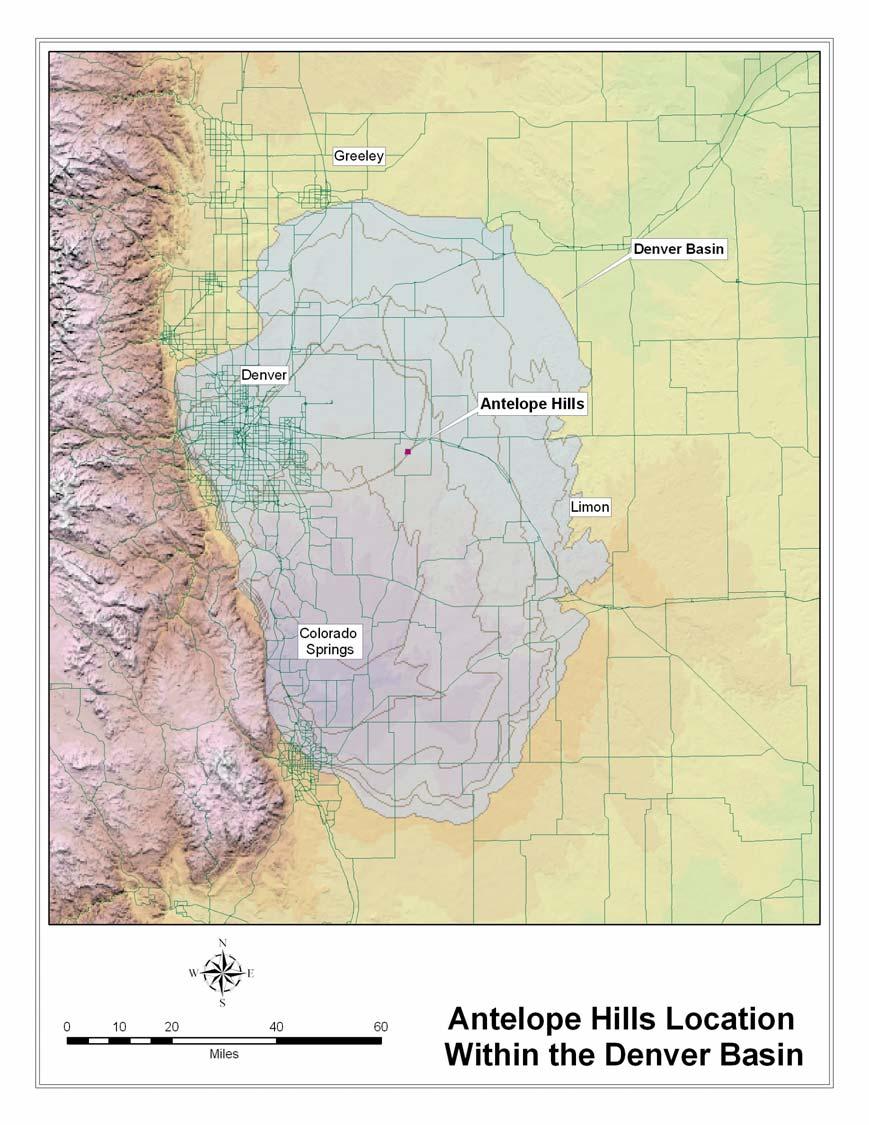
Antelope Hills Directionally Drilled Water Well. Theresa Jehn-Dellaport Jehn Water Consultants, Inc.
|
|
|
- Diana Perry
- 5 years ago
- Views:
Transcription

1 Antelope Hills Directionally Drilled Water Well Theresa Jehn-Dellaport
2 Directional Well Applications Deep Bedrock Aquifers Proven Oil field technology Initial Analysis indicates up to 4 times the production capability More efficient well design Takes advantage of more of the available saturated thickness
3 Discussion Topics Hydrogeology Well Design Permitting Methodology Drilling Completion Development Pumping Test
4 Hydrogeology Sand occurs in horizontal lenses and usually not continuous Depositional Environment East to West
5 Flow in an Anisotropic Aquifer Flow lines do not cross equipotential lines at right angles Estimated that the horizontal conductivity can be up to 10 times that of vertical May also be related to depositional direction
6 U_ARAPAHOE [SGS] U_ARAP_BASE [SGS] L_ARAPAHOE [SGS] L_ARAP_BASE [SGS] LARAMIE [SGS] FXHL [3] MARKER1 [SGS]
7
8 Antelope Hills Small Development, based on ground water Vertical Arapahoe Well Tested 90 gpm Sustained rate 50 to 60 gpm Laramie-Fox Hills higher production,?? Water Quality Need for a higher sustainable rate from the Arapahoe aquifer
9
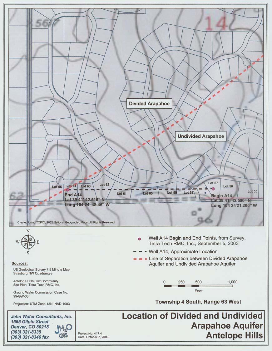
10 Well Design Apply Oil Field Technology Will a directionally drilled oil well design work for water?
11 Oil Field Horizontal Well
12 Oil Field Horizontal Well

13
14 Well Design One sand does not an aquifer make Depositional environment east to west Budget Geophysical log ($$$$!!!!)
15

16
17 Directional Well Goals Arapahoe aquifer is divided Lower aquifer has approximately 3 sand lenses Current vertical well is 60 gpm not sustained Target to increase to 120 gpm sustained
18 Permitting and Variance Approval Permitted as a normal water well permit Directional Portion of the Well Must Remain on the property Must be screened only in the target aquifer Directional Survey of the entire well Geophysical log of the entire well (obtained a variance for Antelope)
19 Methodology More precise than shallow application Use oil field services for the directional drilling Driller provides the equipment Use traditional mud rotary with mud motors Need to keep drilling speed down in water wells for cuttings removal
20
21 Drilling Technology is proprietary to each company used Tools are attached to the bit Also includes a geophysical logging tool on drill stem to determine the formations Signals are sent up the borehole drilling fluid is the conductor for the signal
22 Drilling (Continued) Diaphragm Transducer picks up signal Software translates the signal Based on the magnetic of the earth True north and starting position are critical Traditional mud rotary Use of mud motors and mud pumps
23 Drilling (continued) Slide to build angle, mud motor spins, drill stem does not Rotating maintaining hole TVD Total Vertical Depth TMD Total Measured Depth
24

25
26
27 Completion Screen Gravel Pack? Profile
28 /8-inch Casing Shoe feet (M.D.) inch I.D Lateral Leg SCALE 100 ft 1565 Gilpin St. Denver, CO ANTELOPE HILLS DIRECTIONAL WELL Lithologic Cross-section showing well path and screen placement Job No July 18, 2003 LEGEND Sandstone Layer Shale Layer Screened Interval Cased Interval Arapahoe aquifer Boundary
29

30
31
32 Drilling Issues Rate of Drilling Good Mud Program is Critical Hole Integrity Cuttings Removal
33 Development Use of traditional mud rotary causes significant development concerns Fluids Removal Cautious use of air for development Surge Block Methodology

34
35 Pumping Test Transducers at either end of the well Analysis virtually identical at both ends Compared to vertical Arapahoe Well at site location
36
37 /8-inch Casing Shoe feet (M.D.) inch I.D Lateral Leg SCALE 100 ft 1565 Gilpin St. Denver, CO ANTELOPE HILLS DIRECTIONAL WELL Lithologic Cross-section showing well path and screen placement Job No July 18, 2003 LEGEND Sandstone Layer Shale Layer Screened Interval Cased Interval Arapahoe aquifer Boundary
38
39
40 Dropped from 90 to 80 gpm 80 to 70 gpm 80 to 70 gpm 80 to 70 gpm 70 to 65 gpm Recovery to 80 gpm 70 to 80 gpm 300 Drawdown (ft) Directional Water Level Vertical Water Level Recovery ET (seconds)
41 Recovery Data 48 hr Test Vertical Water Level Directional Water Level Drawdown ET (seconds)
42
43
44
45

46
47 Specific Capacity Existing Vertical Well gpm/ft Directional Well gpm/ft
48 Lessons Learned Development Well Design Oil Field Contractor
49 Next Steps Recharge Increase production Sustainability Modified design

50 /8-inch Casing Shoe feet (M.D.) inch I.D Lateral Leg SCALE 100 ft 1565 Gilpin St. Denver, CO ANTELOPE HILLS DIRECTIONAL WELL Lithologic Cross-section showing well path and screen placement Job No July 18, 2003 LEGEND Sandstone Layer Shale Layer Screened Interval Cased Interval Arapahoe aquifer Boundary
Finding Large Capacity Groundwater Supplies for Irrigation
 Finding Large Capacity Groundwater Supplies for Irrigation December 14, 2012 Presented by: Michael L. Chapman, Jr., PG Irrigation Well Site Evaluation Background Investigation Identify Hydrogeologic Conditions
Alamitos Barrier Improvement Project - UPDATE
 Alamitos Barrier Improvement Project - UPDATE Seal Beach Leisure World Community Meeting Clubhouse 2 August 31, 2016 Orange County Water District Meeting Objectives Overview of OCWD Overview of the Alamitos
MUDLOGGING, CORING, AND CASED HOLE LOGGING BASICS COPYRIGHT. Coring Operations Basics. By the end of this lesson, you will be able to:
 LEARNING OBJECTIVES MUDLOGGING, CORING, AND CASED HOLE LOGGING BASICS Coring Operations Basics By the end of this lesson, you will be able to: Understand why cores are justified and who needs core data
MicroScope. Resistivity- and imagingwhile-drilling
 MicroScope Resistivity- and imagingwhile-drilling service MicroScope Magnify your reservoir Multidepth laterolog resistivity Multidepth borehole images Mud resistivity Azimuthal gamma ray Bit resistivity
Rotary Drilling Rotary Drilling Bits
 GE 343 SUBSURFACE EXPLORATION CH 8 Rock Drilling, Testing, and Sampling Text Ch. 7. Dr. Norbert H. Maerz Missouri University of Science and Technology (573) 341-6714 norbert@mst.edu Instructional Objectives
WELL AND BORING REPORT
 45 0'N 45 0'N South North South North 1905 0 1 Distance in Miles 1: 24,000 (1"=2,000') NAD 1983 UTM Zone 15N Unified maps show subdued modern topo features where corresponding maps of the same year were
Hostile downhole conditions present complex challenges
 Haynesville Shale Hostile downhole conditions present complex challenges Solving challenges. conservative estimates show 168 trillion cubic feet of natural gas Haynesville formation The Haynesville shale
Instructional Objectives
 GE 343 SUBSURFACE EXPLORATION CH 8 Rock Drilling, Testing, and Sampling Text Ch. 7. Dr. Norbert H. Maerz Missouri University of Science and Technology (573) 341-6714 norbert@mst.edu Instructional Objectives
Geophysical Exploration in Water Resources Assessment. John Mundell, P.E., L.P.G., P.G. Ryan Brumbaugh, L.P.G. Mundell & Associates, Inc.
 Geophysical Exploration in Water Resources Assessment John Mundell, P.E., L.P.G., P.G. Ryan Brumbaugh, L.P.G. Mundell & Associates, Inc. Presentation Objective Introduce the use of geophysical survey methods
HOW. HOW vehicle mounted units portable units also available. HOW, WHEN & WHY to Geophysically Log in S.I.?
 HOW, WHEN & WHY to Geophysically Log in S.I.? by Kim Beesley HOW HOW vehicle mounted units portable units also available Access to borehole Depth of borehole sump / rat -hole? 1 HOW? - subject to borehole
PETROPHYSICAL EVALUATION CORE COPYRIGHT. Petrophysical Evaluation Approach and Shaly Sands Evaluation. By the end of this lesson, you will be able to:
 PETROPHYSICAL EVALUATION CORE Petrophysical Evaluation Approach and Shaly Sands Evaluation LEARNING OBJECTIVES By the end of this lesson, you will be able to: Discuss how to approach a petrophysical evaluation
Well Logging Importance in Oil and Gas Exploration and Production
 Well Logging Importance in Oil and Gas Exploration and Production Dr. R. Giri Prasad 1 1 Associate Professor, Dept. of Petroleum Engineering, Aditya Engineering College, hod_pt@aec.edu.in I. INTRODUCTION
Relinquishment Report
 Relinquishment Report Licence P.089 Block 22/15a 2 nd Round Traditional Licence Award (Operator): 100.0% Disclaimer No representation or warranty, express or implied, is or will be made in relation to
KANSAS GEOLOGICAL SURVEY Open File Report LAND SUBSIDENCE KIOWA COUNTY, KANSAS. May 2, 2007
 KANSAS GEOLOGICAL SURVEY Open File Report 2007-22 LAND SUBSIDENCE KIOWA COUNTY, KANSAS Prepared by Michael T. Dealy L.G., Manager, Wichita Operations SITE LOCATION The site was approximately four miles
Shale Development and Hydraulic Fracturing or Frac ing (Fracking) What is it?
 What is it?") P E T R O L E U M E N G I N E E R I N G D E P A R T M E N T Shale Development and Hydraulic Fracturing or Frac ing (Fracking) What is it? Dr. Will Fleckenstein, PE Colorado School of Mines 1 Who is involved
P E T R O L E U M E N G I N E E R I N G D E P A R T M E N T Shale Development and Hydraulic Fracturing or Frac ing (Fracking) What is it? Dr. Will Fleckenstein, PE Colorado School of Mines 1 Who is involved
Petrophysical Data Acquisition Basics. Coring Operations Basics
 Petrophysical Data Acquisition Basics Coring Operations Basics Learning Objectives By the end of this lesson, you will be able to: Understand why cores are justified and who needs core data Identify which
FRACTURE TRACES AND PRODUCTIVITY OF MUNICIPAL WELLS IN THE MADISON LIMESTONE, RAPID CITY, SOUTH DAKOTA
 Proceedings of the South Dakota Academy of Science, Vol. 87 (2008) 261 FRACTURE TRACES AND PRODUCTIVITY OF MUNICIPAL WELLS IN THE MADISON LIMESTONE, RAPID CITY, SOUTH DAKOTA Perry H. Rahn Department of
ILLINOIS GROUNDWATER - BEDROCK
 ILLINOIS GROUNDWATER - BEDROCK Northern Illinois Fresh Water Water Supply Shallow Bedrock Aquifers < 500 depth Deep Bedrock Aquifers > 500 depth Southern Illinois Saline water Oil Fracking Coal Waste injection
Determining In Situ Properties of Claystone Aquitards Using Pore Pressure Responses from Grouted-in Pressure Transducers
 Determining In Situ Properties of Claystone Aquitards Using Pore Pressure Responses from Grouted-in Pressure Transducers Laura A. Smith, S. Lee Barbour, M. Jim Hendry University of Saskatchewan, Saskatoon,
Groundwater Sequence Stratigraphy:
 Groundwater Sequence Stratigraphy: A Geology-based Approach for Developing Accurate and Representative Hydrogeologic Conceptual Models for Successful Groundwater Sustainability Plans Rick Cramer, Burns
Cuyama Basin North Fork Vineyard
 Cuyama Basin North Fork Vineyard Company Background plus Data Insights to Support GSP Development for the Cuyama Basin Presented by Grapevine Capital Partners and Cleath-Harris Geologists April 26th, 2018
The mountain is permeable and fractured: Hydrological Connectivity in the Laramie Range
 WyCHEG Interest Group Meeting, Oct 30, 2017, Laramie, WY The mountain is permeable and fractured: Hydrological Connectivity in the Laramie Range Ye Zhang 1, Brad Carr 1, Shuangpo Ren 2, Andy Parsekian
Geological Survey of Alabama Groundwater Assessment Program
 Geological Survey of Alabama Groundwater Assessment Program Hydrogeologic Characterization and Groundwater Source Development Assessment for Area 2, Southwestern Alabama Gheorghe M. Ponta, Marlon R. Cook,
Ground-Water Exploration in the Worthington Area of Nobles County: Summary of Seismic Data and Recent Test Drilling Results
 Ground-Water Exploration in the Worthington Area of Nobles County: Summary of Seismic Data and Recent Test Drilling Results Jim Berg and Todd Petersen Geophysicists, DNR Waters January 2000 Table of Contents
APPENDIX F OKANAGAN VALLEY SEISMIC SURVEY
 APPENDIX F OKANAGAN VALLEY SEISMIC SURVEY F.1 INTRODUCTION F.2 DISCUSSION OF RESULTS OF 1970 TEST HOLE PROGRAM F.3 CONCLUSIONS 605 APPENDIX F.2 OKANAGAN VALLEY SEISMIC SURVEY By R.M. Lundberg, P. Eng F.1
Module 1 : Site Exploration and Geotechnical Investigation
 Objectives In this section you will learn the following Displacement borings Wash boring Auger boring Rotary drilling Percussion drilling Continuous sampling Boring methods of exploration The boring methods
DRILLING REPORT (DGO-GO-14)
") Commonwealth of Virginia Department of Mines, Minerals, and Energy Division of Gas and Oil P.O. Box 1416; Abingdon, VA 24212 Telephone: (276) 676-5423 Tracking Number: Company: File Number: Operations
Commonwealth of Virginia Department of Mines, Minerals, and Energy Division of Gas and Oil P.O. Box 1416; Abingdon, VA 24212 Telephone: (276) 676-5423 Tracking Number: Company: File Number: Operations
Guideline Petroleum Drilling Regulations (CNR 1150/96)
") Government of Newfoundland and Labrador Department of Natural Resources Guideline Petroleum Drilling Regulations (CNR 1150/96) Topic: Final Well Report Onshore Petroleum Exploratory Wells Ref: Section
Government of Newfoundland and Labrador Department of Natural Resources Guideline Petroleum Drilling Regulations (CNR 1150/96) Topic: Final Well Report Onshore Petroleum Exploratory Wells Ref: Section
Wisconsin s Hydrogeology: an overview
 2012 Soil and Water Conservation Society Conference Stevens Point, WI Feb 9, 2012 Wisconsin s Hydrogeology: an overview Ken Bradbury Wisconsin Geological and Natural History Survey University of Wisconsin-Extension
Horizontal well Development strategy
 Horizontal well Development strategy Pakawas Mangkang Team Member Yoseph Partono Stephan Otero Duangdao Chutanukarn Warin Lobtong Suarporn Ketpreechasawat B8/32 Asset, Thailand Chiangmai, 11 th Nov-13
Heterogeneity Type Porosity. Connected Conductive Spot. Fracture Connected. Conductive Spot. Isolated Conductive Spot. Matrix.
 Porosity Histogram Porosity Contribution 1.3.3.3 Connected 9.8 ohm.m U R D 9 18 7. 5.25 4.38 3.5 2.63 1.75 48 Heterogeneity Distribution Image Orientation, L U 27 36.4.3 X,X72.5 Depth, ft.3 1 Isolated.3
DRILLING REPORT (DGO-GO-14)
") Commonwealth of Virginia Department of Mines, Minerals, and Energy Division of Gas and Oil P.O. Box 1416; Abingdon, VA 24212 Telephone: (276) 676-5423 Tracking Number: Company: File Number: Operations
Commonwealth of Virginia Department of Mines, Minerals, and Energy Division of Gas and Oil P.O. Box 1416; Abingdon, VA 24212 Telephone: (276) 676-5423 Tracking Number: Company: File Number: Operations
THE MINISTRY OF ENERGY AND ENERGY INDUSTRIES MINERALS DIVISION MINE DESIGN TEMPLATE OPERATOR NAME: OPERATOR ADDRESS: PHONE NUMBER: FACSIMILE:
 THE MINISTRY OF ENERGY AND ENERGY INDUSTRIES MINERALS DIVISION MINE DESIGN TEMPLATE 1.0 GENERAL INFORMATION OPERATOR NAME: OPERATOR ADDRESS: PHONE NUMBER: FACSIMILE: NAME OF CONTACT: CELLULAR PHONE: EMAIL
Characterization of Geologic Anomalies Through Horizontal Directional Drilling
 Characterization of Geologic Anomalies Through Horizontal Directional Drilling operators have begun to realize the exploration potential of data obtained from Horizontal Directional Drilling ( HDD ). Localized
TEMPERATURE GEOTHERMAL SYSTEM *.BY. Roger F. Harrison Salt Lake City, Utah. C; K. Blair
 - * f c * -6 9 -.I. lcal '. DEVELOPMENT AND TESTSNG OF A SMALL MODERATE TEMPERATURE GEOTHERMAL SYSTEM *.BY Roger F. Harrison Terra Tek, Inc. Salt Lake City, Utah C; K. Blair Terra Tek, Inc. - Salt Lake
- Groundwater Supply (Fanny Bay to Nanoose Bay)
") I@ Mr. A. P. Kohut Senior Geological Engineer Groundwater Section Date: October 5, 1979 File: NTS 92F Re: Proposed Vancouver Island Fish Hatchery. - Groundwater Supply (Fanny Bay to Nanoose Bay) INTRODUCTION
I@ Mr. A. P. Kohut Senior Geological Engineer Groundwater Section Date: October 5, 1979 File: NTS 92F Re: Proposed Vancouver Island Fish Hatchery. - Groundwater Supply (Fanny Bay to Nanoose Bay) INTRODUCTION
IN SITU SPECIFIC GRAVITY VS GRAIN SIZE: A BETTER METHOD TO ESTIMATE NEW WORK DREDGING PRODUCTION
 IN SITU SPECIFIC GRAVITY VS GRAIN SIZE: A BETTER METHOD TO ESTIMATE NEW WORK DREDGING PRODUCTION Nancy Case O Bourke, PE 1, Gregory L. Hartman, PE 2 and Paul Fuglevand, PE 3 ABSTRACT In-situ specific gravity
David de Courcy-Bower and Samuel Mohr
 Applicability and Limitations of LNAPL Transmissivity as a Metric within Bedrock Formations Insert then choose Picture select your picture. Right click your picture and Send to back. David de Courcy-Bower
IAEA SAFETY STANDARDS Geotechnical Aspects of Site Evaluation and Foundations in NPPs, NS-G-3.6
 IAEA SAFETY STANDARDS Geotechnical Aspects of Site Evaluation and Foundations in NPPs, NS-G-3.6 Regional Workshop on Volcanic, Seismic, and Tsunami Hazard Assessment Related to NPP Siting Activities and
Groundwater in Bedrock Aquifers: Development Considerations
 Slide 1 Groundwater in Bedrock Aquifers: Development Considerations Pelham, New Hampshire October 3, 2016 Building Trust. Engineering Success. Slide 2 OUTLINE Background on groundwater in bedrock aquifers
GeothermEx, Inc. GEOTHERMAL RESERVOIR ASSESSMENT METHODOLOGY FOR THE SCIENTIFIC OBSERVATION HOLE PROGRAM, KILAUEA EAST RIFT ZONE, HAWAII TASK 1 REPORT
 (415) 527 9876 CABLE ADDRESS- GEOTHERMEX TELEX 709152 STEAM UD FAX (415) 527-8164 Geotherm Ex, Inc. RICHMOND. CALIFORNIA 94804-5829 GEOTHERMAL RESERVOIR ASSESSMENT METHODOLOGY FOR THE SCIENTIFIC OBSERVATION
Dunkerrin - Guilfoyles Well
 Water Framework Directive Groundwater Monitoring Programme Site Information Dunkerrin - Guilfoyles Well ImagePath1: Dunkerrin - Guilfoyles Well\IE_SH_G_19_005_a_Pump House_(800_x_600).jpg Dunkerrin/ Guilfoyles
U.S. Department of the Interior Alaska Rural Energy Project
 U.S. Department of the Interior Alaska Rural Energy Project Results from the Coalbed Methane Exploration and Testing Project Wainwright, Alaska 2007-2008 2008 Art Clark U.S. Geological Survey, Denver,
Case Study: University of Connecticut (UConn) Landfill
 Landfill") Case Study: University of Connecticut (UConn) Landfill Problem Statement:» Locate disposal trenches» Identify geologic features and distinguish them from leachate and locate preferential pathways in fractured
Case Study: University of Connecticut (UConn) Landfill Problem Statement:» Locate disposal trenches» Identify geologic features and distinguish them from leachate and locate preferential pathways in fractured
RIG HYDRAULICS. P 1 = Eρ 0.8 Q 1.8 (PV) 0.2. psi or bar. P 1 ρ. = pressure loss, psi or bar = Density, ppg or kg/l = flow rate, gpm, l/min
 0.2. psi or bar. P 1 ρ. = pressure loss, psi or bar = Density, ppg or kg/l = flow rate, gpm, l/min") RIG HYDRAULICS This chapter covers the following items: Pressure losses Surface connection losses Pressure drop across the bit Optimization of bit hydraulics Surface pressure drop Hydraulic criteria Comparison
RIG HYDRAULICS This chapter covers the following items: Pressure losses Surface connection losses Pressure drop across the bit Optimization of bit hydraulics Surface pressure drop Hydraulic criteria Comparison
SASKATCHEWAN STRATIGRAPHY GLACIAL EXAMPLE BOULDERS IN GLACIAL DEPOSITS
 SASKATCHEWAN STRATIGRAPHY GLACIAL EXAMPLE BOULDERS IN GLACIAL DEPOSITS 51 SASKATCHEWAN STRATIGRAPHY GLACIAL SURFICIAL STRATIFIED DEPOSITS 52 SASKATCHEWAN STRATIGRAPHY GLACIAL EXAMPLE OF SEDIMENT DEPOSITION
DEVEX Moving in the Right Direction; Realising Upside Potential in a Mature Field Using Real Time 3D Geo-Steering Technology
 DEVEX 2010 Moving in the Right Direction; Realising Upside Potential in a Mature Field Using Real Time 3D Geo-Steering Technology Authors: Lisa Chisholm, Chevron Upstream Europe David Holbrough, Baker
ARES ENERGY, LTD. SDI Survey Report. Fuhrman-Mascho Andrews County, Texas (Grid North) University 13 #2H VH - Job # KW-204.
 University 13 #2H VH - Job # KW-204.") ARES ENERGY, LTD. Fuhrman-Mascho Andrews County, Texas (Grid North) University 13 #2H VH - Job #320214-KW-204 Survey: Gyro SDI Survey Report 17 February, 2014 SDI SDI Survey Report Company: ARES ENERGY,
ARES ENERGY, LTD. Fuhrman-Mascho Andrews County, Texas (Grid North) University 13 #2H VH - Job #320214-KW-204 Survey: Gyro SDI Survey Report 17 February, 2014 SDI SDI Survey Report Company: ARES ENERGY,
DESIGN OF AN ULTRA-SPEED LAB-SCALE DRILLING RIG FOR SIMULATION OF HIGH SPEED DRILLING OPERATIONS IN HARD ROCKS. *V. Rasouli, B.
 DESIGN OF AN ULTRA-SPEED LAB-SCALE DRILLING RIG FOR SIMULATION OF HIGH SPEED DRILLING OPERATIONS IN HARD ROCKS *V. Rasouli, B. Evans Department of Petroleum Engineering, Curtin University ARRC Building,
Water Framework Directive. Groundwater Monitoring Programme. Site Information. Drum Bingahamstown
 Water Framework Directive Groundwater Monitoring Programme Site Information Drum Bingahamstown ImagePath1: Drum Bingahamstown\IE_WE_G_16_ 1_a_Spring.jpg Drum Binghamstown is a spring that is used for a
R ENW Services - Geophysics & GIS
 Yankton Block 1 Vermillion Block 2 N 2 0 1 Block 3 Elk Point 2 3 4 5 6 MILES Block 4 R20-2002-01 0 1 2 3 4 5 6 7 8 9 10 KILOMETERS Block 5 Figure courtesy of ENW Services - Geophysics & GIS Block 6 Test
Predicting the path ahead
 Predicting the path ahead Horizontal drilling has become a routine procedure in many parts of the world and is particularly popular in the Middle East. Despite increasing familiarity with the techniques,
Downhole Navigation for Oil & Gas Drilling
 Downhole Navigation for Oil & Gas Drilling Martin E. Poitzsch Research Director, Sensor Physics Schlumberger-Doll Research, Cambridge, MA A Division of Schlumberger Ltd. Outline Importance of Accurate
Somenath Kar*, Krishnendu Ghosh*, Arnab Ghosh*, Koushik Sikdar*, Udit Kumar Guru*, Priyanka Bhattacharya*, K.M Sundaram**, G M Chavan**
 P-419 Summary Characterizing the Clay Particle distribution in Deepwater Channel Levee Complex using Borehole Micro Image and Multi Triaxial Induction Measurement: A Case Studies from Eastern Offshore
Guideline REGULATORY REQUIREMENTS FOR FINAL WELL REPORTS ONSHORE TO OFFSHORE WELLS
 Guideline REGULATORY REQUIREMENTS FOR FINAL WELL REPORTS ONSHORE TO OFFSHORE WELLS 1. Introduction The requirement to prepare and submit a Final Well Report is specified by subsection 201(1) of the Newfoundland
Geologic influence on variations in oil and gas production from the Cardium Formation, Ferrier Oilfield, west-central Alberta, Canada
 Geologic influence on variations in oil and gas production from the Cardium Formation, Ferrier Oilfield, west-central Alberta, Canada Marco Venieri and Per Kent Pedersen Department of Geoscience, University
MULTI-DISCIPLINARY TEAMWORK DELIVERS OUTSTANDING KRECHBA HORIZONTAL WELL PERFORMANCE
 6 JOURNEES SCIENTIFIQUES ET TECHNIQUES Hôtel Hilton, 20 to 22 june 2004, Algiers, Algeria MULTI-DISCIPLINARY TEAMWORK DELIVERS OUTSTANDING KRECHBA HORIZONTAL WELL PERFORMANCE FOSTER, L. AIDOO, A. TOURQUI,
RESISTIVITY IMAGING AND BOREHOLE INVESTIGATION OF THE BANTING AREA AQUIFER, SELANGOR, MALAYSIA. A.N. Ibrahim Z.Z.T. Harith M.N.M.
 JOURNAL OF ENVIRONMENTAL HYDROLOGY The Electronic Journal of the International Association for Environmental Hydrology On the World Wide Web at http://www.hydroweb.com VOLUME 11 2003 RESISTIVITY IMAGING
June 9, R. D. Cook, P.Eng. Soils Engineer Special Services Western Region PUBLIC WORKS CANADA WESTERN REGION REPORT ON
 PUBLIC WORKS CANADA WESTERN REGION REPORT ON GEOTECHNICAL INVESTIGATION PROPOSED MARTIN RIVER BRIDGE MILE 306.7 MACKENZIE HIGHWAY Submitted by : R. D. Cook, P.Eng. Soils Engineer Special Services Western
With generous support from:
 Hydrogeology Concepts and Exercise Brought to you by Core Kids, WMU-MGRRE MGRRE Geosciences K-12 Outreach Program With generous support from: In this presentation and data-based exercise students will:
May 4, Mr. Bruce Hampson Town of Wilton Miller-Driscoll School Building Committee 238 Danbury Road Wilton, Connecticut 06897
 May 4, 2015 Mr. Bruce Hampson Town of Wilton Miller-Driscoll School Building Committee 238 Danbury Road Wilton, Connecticut 06897 RE: Focused Soil Investigation Miller-Driscoll School Wilton, CT TRC Project
MIDDLE DEVONIAN PLAY MICHIGAN BASIN OF ONTARIO. Duncan Hamilton
 MIDDLE DEVONIAN PLAY MICHIGAN BASIN OF ONTARIO Duncan Hamilton 1 Middle Devonian Pools of the Michigan Basin 375+ Million Barrels Michigan 45+ million Barrels Ontario 2 Outline of Presentation History
2014 DEVEX Conferences, Aberdeen, May 6 th 2014 Morteza Akbari. 6 th and 7 th May Baker Hughes Incorporated. All Rights. Reserved.
 6 th and 7 th May Analyzing the Correlations in Generalization of the Reservoir Information in a Well Completion Design Optimization using ICD s along the Horizontal section of a Wellbore 2014 DEVEX Conferences,
X,800. X,850 ft. X,900 ft. X,950 ft. X,000 ft. GeoSphere. Reservoir Mapping-While-Drilling Service
 X,800 X,850 ft X,900 ft X,950 ft X,000 ft GeoSphere Reservoir Mapping-While-Drilling Service Discover reservoir mapping-while-drilling...... and reveal subsurface beddings and fluid contacts at the reservoir
Introduction to Formation Evaluation Abiodun Matthew Amao
 Introduction to Formation Evaluation By Abiodun Matthew Amao Monday, September 09, 2013 Well Logging PGE 492 1 Lecture Outline What is formation evaluation? Why do we evaluate formation? What do we evaluate?
The Bakken. A Non-Shale Shale Play. August 2010
 The Bakken A Non-Shale Shale Play August 2010 ConocoPhillips Unconventional Resource Experience in North America CBM San Juan Drunkards Wash Uinta Powder River Horseshoe Canyon Manville Shale Barnett Haynesville
Oil Company Company et al Foothills W6
 800, 555 4 th Avenue SW, Calgary, AB T2P 3E7 Off: 403-234-7625, www.wellsitegeologists.com Cell: 660-9883, Dennis@WellsiteGeologists.com Geological Report for Oil Company Company et al Foothills 06-06-060-06W6
IPTC Abstract. Introduction
 IPTC 14538 Doubling a Marginal Field's Reserves by Understanding the Application of "Enabling" Technology Ong Tee Suan, Newfield Exploration; Mark Lambert, Newfield Sarawak Malaysia Inc; Barry Goodin,
Oola PWS - Carrigmore BH
 Water Framework Directive Groundwater Monitoring Programme Site Information Oola PWS - Carrigmore BH ImagePath1: Oola PWS - Carrigmore BH\OolaPWSCarrigmore1.jpg Oola PWS Carrigmore BH is a borehole used
Coating Requirements for Pipelines Installed by Horizontal Directional Drilling John D. Hair, P.E.*
 Coating Requirements for Pipelines Installed by Horizontal Directional Drilling John D. Hair, P.E.* *President, J. D. Hair & Associates, Inc., 2121 South Columbia Avenue, Suite 101, Tulsa, OK 74114-3502;
Soils, Hydrogeology, and Aquifer Properties. Philip B. Bedient 2006 Rice University
 Soils, Hydrogeology, and Aquifer Properties Philip B. Bedient 2006 Rice University Charbeneau, 2000. Basin Hydrologic Cycle Global Water Supply Distribution 3% of earth s water is fresh - 97% oceans 1%
Exploration, Drilling & Production
 Nontechnical Guide to PETMOLEUM Geology, Exploration, Drilling & Production Third Edition Norman J. Hyne, Ph.D. Contents Preface *i Introduction 1 The Nature of Gas and Oil 1 Petroleum 1 The Chemistry
Strategies for Combating Rock
 Strategies for Combating Rock Tod Michael Trenchless Product Manager, Vermeer Corporation Curt Dubbin Sale Manager HDD Division, Mincon Inc. Strategies for Combating Rock This presentation is intended
Combining geological surface data and geostatistical model for Enhanced Subsurface geological model
 Combining geological surface data and geostatistical model for Enhanced Subsurface geological model M. Kurniawan Alfadli, Nanda Natasia, Iyan Haryanto Faculty of Geological Engineering Jalan Raya Bandung
Multi-target wells: a new concept to improve well economics
 Multi-target wells: a new concept to improve well economics OMV AG, Vienna, Austria ABSTRACT: The Vienna Basin is a sedimentary basin more than 10 km in thickness and composed of more than a dozen hydrocarbon
Hydraulic and Water-Quality Characterization of Fractured-Rock Aquifers Using Borehole Geophysics
 Hydraulic and Water-Quality Characterization of Fractured-Rock Aquifers Using Borehole Geophysics John H. Williams Office of Ground Water Troy, New York Flow in Open Borehole Runkel and others (2003) Ambient
BAUER MeBo Sea Bed Drill Rig
 BAUER MeBo Sea Bed Drill Rig Spotlights BAUER Maritime Experiences 1993 Diamond deposit exploration with a BC cutter in water depth of 160 m (South Africa) Atlantic Ocean 2005 Drilling inside of a monopile
INNOVATIVE TECHNIQUES TO INVESTIGATE CONTAMINATION IN FRACTURED BEDROCK
 INNOVATIVE TECHNIQUES TO INVESTIGATE CONTAMINATION IN FRACTURED BEDROCK Abstract Christopher Gaule 1, Kenneth Goldstein 2, Grant Anderson 3 Watervliet Arsenal, located in Watervliet, New York, is the oldest
Torque and drag modelling for Redhill South-1 in the Northern Perth Basin, Australia
 Petroleum and Mineral Resources 97 Torque and drag modelling for Redhill South-1 in the Northern Perth Basin, Australia S. Smith & V. Rasouli Department of Petroleum Engineering, Curtin University, Australia
Drillworks. DecisionSpace Geomechanics DATA SHEET
 DATA SHEET Drillworks overview DecisionSpace Geomechanics Key features Pre-drill, real-time, and post-drill analyses are all easily performed in one application using the latest data from across the field
FS Original Hole Ft April 26, 2016
 Oilfield Services, Central U.S. Land PathFinder A Schlumberger Company Drilling Group Geo Market Area: South East Texas Basin 3600 BriarPark Houston, Texas 77042 Phone : (713) 789-9600 (Main) Fax : (713)
SITE INVESTIGATION 1
 SITE INVESTIGATION 1 Definition The process of determining the layers of natural soil deposits that will underlie a proposed structure and their physical properties is generally referred to as site investigation.
STRUCTURAL STABILITY ASSESSMENT
 STRUCTURAL STABILITY ASSESSMENT CFR 257.73(d) Bottom Ash Pond Complex Cardinal Plant Brilliant, Ohio October, 2016 Prepared for: Cardinal Operating Company Cardinal Plant Brilliant, Ohio Prepared by: Geotechnical
Water Framework Directive. Groundwater Monitoring Programme. Site Information. Galbally
 Water Framework Directive Groundwater Monitoring Programme Site Information Galbally ImagePath1: Galbally\Galbally1.jpg Galbally source is comprised of 2 boreholes situated in Devonian Old Red Sandstones
EFFECTIVENESS OF HYDROFRACTURE PREDICTION FOR HDD DESIGN
 North American Society for Trenchless Technology (NASTT) No-Dig Show 2010 Chicago, Illinois May 2-7, 2010 Paper F-1-01 EFFECTIVENESS OF HYDROFRACTURE PREDICTION FOR HDD DESIGN Kimberlie Staheli, Ph.D.,
KARST MAPPING WITH GEOPHYSICS AT MYSTERY CAVE STATE PARK, MINNESOTA
 KARST MAPPING WITH GEOPHYSICS AT MYSTERY CAVE STATE PARK, MINNESOTA By Todd A. Petersen and James A. Berg Geophysics Program Ground Water and Climatology Section DNR Waters June 2001 1.0 Summary A new
Applying Stimulation Technology to Improve Production in Mature Assets. Society of Petroleum Engineers
 Applying Stimulation Technology to Improve Production in Mature Assets Alexandr Mocanu Well Production Services, Schlumberger Visegrád, 19 November 2015 Society of Petroleum Engineers 1 Agenda Formation
Cappog Bridge (PW-3)
") Water Framework Directive Groundwater Monitoring Programme Site Information Cappog Bridge (PW-3) ImagePath1: Cappog Bridge\IEGBNI_NB_G_012_18_0 01_A_SiteLocation.jpg Cappog Bridge PW-3 is one of 8 boreholes
Water Framework Directive Groundwater Monitoring Programme Site Information Cappog Bridge (PW-3) ImagePath1: Cappog Bridge\IEGBNI_NB_G_012_18_0 01_A_SiteLocation.jpg Cappog Bridge PW-3 is one of 8 boreholes
Seismoelectric Ground-flow DC-4500 Locator
 Seismoelectric Ground-flow DC-4500 Locator Introduction The seismoelectric survey is a new technology combined the electro kinetic potential method and geophysical technology. It is applied directly to
PHASE II LARAMIE MONITOR WELL PROJECT REPORT
 PHASE II LARAMIE MONITOR WELL PROJECT REPORT June 18, 2015 Submitted to: City of Laramie P.O. Box C Laramie, Wyoming 82073 Prepared by: Bern Hinckley, P.G. Chris Moody, P.G. Hinckley Consulting Wyoming
6.1.6 Sampling, Measurement and Testing. 1) Sampling
 Sampling") 6.1.6 Sampling, Measurement and Testing 1) Sampling In the course of drilling at each borehole, the data of all formations encountered was logged while drilling and a record was made of all variations
6.1.6 Sampling, Measurement and Testing 1) Sampling In the course of drilling at each borehole, the data of all formations encountered was logged while drilling and a record was made of all variations
Horizontal Drilling Pilot In a Shallow Heavy Oil Reservoir in Northwestern Romania. Authors: John Lavelle, Amin Yaghoobi
 Horizontal Drilling Pilot In a Shallow Heavy Oil Reservoir in Northwestern Romania Authors: John Lavelle, Amin Yaghoobi About Suplac Oil Field Discovered 1958 Oil Density 960 kg/m3 (16 API) Viscosity 2300
Water Framework Directive. Groundwater Monitoring Programme. Site Information. Kiltrough PWS
 Water Framework Directive Groundwater Monitoring Programme Site Information Kiltrough PWS ImagePath1: Kiltrough PWS\17_009_Kiltough_P1_SiteLo cation.jpg This monitoring point is a well that is part of
Petrophysical Data and Open Hole Logging Operations Basics COPYRIGHT. Introduction to Petrophysical Data and Open Hole Logging Operations Basics
 Learning Objectives Petrophysical Data and Open Hole Logging Operations Basics Introduction to Petrophysical Data and Open Hole Logging Operations Basics By the end of this lesson, you will be able to:
Advances in Geosteering
 Advances in Geosteering SMART4D While Drilling Geosteering Marcellus Case Study Joint Presentation: Feb 27 th 2014, Houston, TX Rocky Mottahedeh, P.Geol. P.Eng. EOW Report University_31_18_2H Advances
ractical Geomechanics for Oil & Gas Industry
 P ractical Geomechanics for Oil & Gas Industry Practical Geomechanics for Oil and Gas Industry The integrity of the wellbore plays an important role in petroleum operations including drilling, completion
How to Identify and Properly Classify Drill Cuttings
 How to Identify and Properly Classify Drill Cuttings (Creating Useful Borehole Logs) Dave Larson Hydrogeology and Geophysics Section Accurate information about the borehole location and a careful description
GEOPHYSICAL IMAGING TO ENHANCE ANALYSIS, DESIGN AND DRILLING OF LARGE-SCALE GEOTHERMAL SYSTEMS. Abstract
 GEOPHYSICAL IMAGING TO ENHANCE ANALYSIS, DESIGN AND DRILLING OF LARGE-SCALE GEOTHERMAL SYSTEMS John A. Mundell, Mundell & Associates, Inc., Indianapolis, Indiana Gabriel Hebert, Mundell & Associates, Inc.,
Geological Mapping using Geophysics
 Geological Mapping using Geophysics Pugin, A.J.M. and T.H. Larson Illinois State Geological Survey, 615 E Peabody Dr., Champaign, IL 61820; E-mail: A.J.M. Pugin at pugin@isgs.uiuc.edu Mapping Techniques.
INTRODUCTION TO LOGGING TOOLS
 BY: MUHAMMAD ZAHID INTRODUCTION TO LOGGING TOOLS 1- SPONTANEOUS POTENTIAL (SP) The Spontaneous potential survey, (sp) was one of the first measurements, which was carried out, in a well bore. The SP log