Petrophysical Data and Open Hole Logging Operations Basics COPYRIGHT. Introduction to Petrophysical Data and Open Hole Logging Operations Basics
|
|
|
- Anthony King
- 5 years ago
- Views:
Transcription

1 Learning Objectives Petrophysical Data and Open Hole Logging Operations Basics Introduction to Petrophysical Data and Open Hole Logging Operations Basics By the end of this lesson, you will be able to: Understand the role of Petrophysics and why it is critical to the oil and gas business Understand the relationship of Petrophysics to Geology, Geophysics, and Reservoir Engineering Complete basic calculation of oil volume in a reservoir and explain which petrophysical parameters are required Recognize the difference in the Static (Geologic) Model and the Dynamic (Reservoir Simulation) Model Identify key parameters of the Earth Model and what a normal pressure gradient is in psi/ft and ppg 1


2 What is Petrophysics? Petrophysics is derived from the Greek word petra meaning "rock" and physis meaning "nature" As defined by an SPE Reprint, petrophysics is the study of the physical and chemical properties of rocks and their contained fluids. Petrophysics uses rock properties and relationships among these rock properties to identify and evaluate hydrocarbon reservoirs, source rocks, seals and aquifers Gus Archie is the known as the Father of Petrophysics Petrophysics plays a fundamental role in description, characterization and evaluation of rock-fluid packages Why Petrophysics is Fundamental Petrophysics consists of: Geology Petrophysics Reservoir Engineering Mechanical Engineering Drilling Geophysics Geophysics Geology Reservoir Engineering 2


3 Give Me a Few Glue Examples Attic Reservoir hydrocarbons compartmentalization Produces On the inshore out of blocks the Gething of Angola sandstone Fine-grained Series of anastomosing sandstone channels which cut across from each other Contains Each bounding approximately surface of 3 percent the channels potassium serve feldspar as a vertical or lateral A zone permeability that looked barrier like silty shale was first drilled through. It was assumed that the entire package was hydrocarbon bearing As drilling continued, the drilling fluid was carefully engineered and resulted Pressure in tests, an exceptionally repeat formation prolific tests wet or gas drill reservoir. stem tests were run The life Did of not the produce field was uniformly extended by 30 years because it consisted of attic Pressure hydrocarbons. and gas-oil ratios were variable Different reservoirs were identified using core and rock typing Core and log data were integrated to determine continuity and connectivity. What is a Petrophysicist? A petrophysicist is a petrophysical engineer A petrophysicist is responsible for planning, acquiring and interpreting borehole data. Data sources include mudlogs and openhole and cased hole well logs. 3
4 The Petrophysics Continuum Stage or Phase 1. Rank Exploration 2. Field Discovery 3. Field Development 4. Secondary Recovery 5. Tertiary Recovery 6. Field Maintenance 7. Field Abandonment 8. Remediation KNOWLEDGE INCREASE Petrophysical Data Sources Reservoir characterization requires competent integration of data from many sources! Cuttings Hydrocarbon Analysis Cores Logs Fluid/Pressure Tests PROBLEMS INCREASE Key Learning Points Petrophysics Applies at All Levels! 4


5 The Petrophysical Scene Multiple Scales Petrophysics Related Activities Phase Activity Formation Evaluation Method 1. Exploration Define Structure Seismic, Gravity, Magnetics 2. Drilling Drill Well Mud Logging, Coring, MWD, LWD 3. Logging Log Well Open-hole Logs 4. Primary Evaluation Log Analysis and Testing Sidewall Cores. VSP, Wireline FT, DST 5. Analysis Core & Fluid Analysis Laboratory Studies 6. Feedback Refinement of Seismic Model Time/Depth Calibration Integrated Field Study Log/Core Calibration 7. Exploitation Producing Hydrocarbons Material Balance Analysis Production Logging Production Log analysis 8. Secondary Recovery Assisted Lifting Flood Efficiency Analysis Water or Gas Injection Micro-rock Property Analysis 9. Abandonment Economic Decisions Highlighted in yellow are most critical petrophysical phases 5


6 The Hydrocarbon Volume and Petrophysical Data Oil Vol = A*h*(N/G)*porosity*(1-Sw) where: Area A = 1000 sq. ft. Thickness, h = 100 ft Net to Gross, N/G = 60% Porosity = 20% Water Saturation, Sw = 10% What is the oil volume in place in this subsurface reservoir Oil Vol = bbls? And, what inputs are from petrophysical data? HCVOL= A*h* (N/G)*por*(1-Sw) where: A = 1000 sq. ft., h = 100 ft, N/G = 60%, Por = 20%, Sw = 10% HCVOL = 1000 x 100 x.6 x.2 x.9 = ft 3 cu ft x.1781 bbl/ft 3 HCVOL= 1923 bbl oil Oil Vol = 1923 bbls. Key Parameters in Earth Model In order to use logs and cores to understand the Earth; corrections are needed for: Pressure Water Salinity Temperature Water Density Borehole/Formation Environment 6

7 Earth Model: Temperature and Pressure Gradients Geothermal Gradient Gradual increase of temperature with increasing depth (e.g., 1ºF/100ft) Petrophysical Effects Influences on logs Activity level of ions in subsurface waters increase with depth Drilling mud properties can change with depth Certain wireline tools are effective only within certain temperature ranges Influences all facets of well design Earth Model: Pressure Gradients Overburden Pressure gradual increase of pressure with increasing depth in the earth's crust (e.g., 1.1psi/ft) OP = FP + GP Hydrostatic Pressure gradual increase of pressure in a fluid column: 0.43 psi/ft (fresh water) psi/ft ( normal pressured salt water) 0.35 psi/ft for (oil) 0.08psi/ft for gas Petrophysical Effects Fundamental control on phi-k (porosity-permeability) Significant influence on well design Influences logs Certain wireline tools are effective only within certain pressure ranges 7


8 Temperature and Pressure Gradient Summary Important inputs for many petrophysical applications include: Formation Temperature Formation Pressure Fluid Densities These corrected parameters are used for: Log Analysis Completion Planning Producibility Estimates Where Does Petrophysics Fit in Reservoir Analysis? The task for reservoir scientists (geologists, petrophysicists, engineers) is to locate hydrocarbon reservoirs and evaluate the oil and gas recoverable volumes. Requires detailed description, characterization of reservoir rocks and associated seals/aquifers Data Sources Seismic Data 2D, 3D and 4D Geological Interpretation of Facies and Rock Types Petrophysical Data Logs, Cores, Test Data Production Data Fluid Properties Data 8
 5. Mapping, volumetric determination 6.")


9 Petrophysics Integral to Reservoir Analysis 1. Seismic analysis 2. Define container (trap size) 3. Petrophysical characteristics 4. Geologic modeling (and rock typing) 5. Mapping, volumetric determination 6. Model validation 7. Interwell modeling Petrophysics An Important Piece BUT, Only a Piece Petrophysical answers are indirect Also true of static and dynamic reservoir models Engineering Geology Key Learning Points Integrating petrophysics occurs in all steps! When appropriate subsurface data is gathered, the results are valid and lead to good business solutions Petrophysics Geophysics There is never a unique solution but integration of all data narrows down the solutions to a set of valid ones. 9
10 How Does Petrophysics Integrate? (Borehole) Seismic LWD Wireline Logs Reservoir monitoring Mudlog data Core data Static model (Geologic model) Learning Objectives Open hole logs Resistivity Nuclear Acoustic Other Corrections: Invasion Layering Deviation Interpretation models incl. QC & Uncertainty Cased hole logs Nuclear Production logs Other Field studies Dynamic model (Reservoir Simulation model) Understand the role of Petrophysics and why it is critical to the oil and gas business Understand the relationship of Petrophysics to Geology, Geophysics, and Reservoir Engineering Complete basic calculation of oil volume in a reservoir and explain which petrophysical parameters are required Recognize the difference in the Static (Geologic) Model and the Dynamic (Reservoir Simulation) Model Identify key parameters of the Earth Model and what a normal pressure gradient is in psi/ft and ppg 10
11 Learning Objectives Petrophysical Data and Open Hole Logging Operations Basics Open Hole Logging Operations By the end of this lesson, you will be able to: Understand Wireline Logging operations, equipment, and procedures Understand the role of Wireline Logging Engineers and Operators Identify the major components of a wireline logging unit Identify the primary open hole logging tools run for Petrophysical Evaluation List the measurement units for the primary open hole logs Specify the typical logging tools combinations run for Exploration and Development wells 11


12 Wireline Logging Operations Equipment Conventional wireline open hole logs LWD Logging While Drilling Built into drill collars and run near the bit Depth and Log displays Calibrations and Accuracy Wireline Logging Surface Logging Unit Signal Conditioner Transmission Via Cable Sensor Logging Tool 12

13 Wireline Acquisition in 1927 The First Log Data Acquisition Now Typical Land Wireline Unit First well run by Schlumberger in 1927 They devised a way to run electrodes into wellbores filled with water based mud They invented the first electric resistivity log They named it Lateral Log Early logs were manually recorded as station readings The wireline wench was cranked by hand Typical Off-Shore Wireline Unit courtesy of Schlumberger courtesy of Baker Hughes 13


14 Wireline Logging Truck A Modern Logging Unit Wireline Winch Computers 14


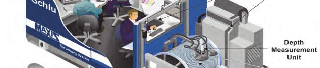


15 Surface Acquisition Unit Well Logs Lower Sheave Wheel Logging truck with Recording equipment Cable Drum Upper Sheave Wheel Rig Blow Out Preventers (BOP) Logging Tool Cap Rock Water Oil 15
 Nuclear (Density, Neutron) Acoustic Nuclear Magnetic Resonance Formation Imaging Sampling (pressures and fluids) 4-Arm")
16 Open Hole Logging Tools Offshore Logging Unit Land (Onshore) Logging Truck Courtesy: Weatherford, Intl. Open Hole Logging Tools Open Hole Logs Resistivity (Laterolog, Induction) Nuclear (Density, Neutron) Acoustic Nuclear Magnetic Resonance Formation Imaging Sampling (pressures and fluids) 4-Arm Dipmeter (pad device) Induction Log with standoffs Density Log (pad device) Sidewall Sample Gun Formation Properties Rock type Porosity Permeability Fluid type (oil, gas, water) Fluid Volume (saturation) Formation tops Fractures 16


17 Log Heading Well and Tool Sketch Short Tool Strings The New Standard Conventional Logging Tools Compact Triple Combo Compact Logging Tools Note: For a Quad Combo add an Acoustic Log 17
18 Learning Objectives Understand Wireline Logging operations, equipment, and procedures Understand the role of Wireline Logging Engineers and Operators Identify the major components of a wireline logging unit Identify the primary open hole logging tools run for Petrophysical Evaluation List the measurement units for the primary open hole logs Specify the typical logging tools combinations run for Exploration and Development wells 18
19 Learning Objectives Petrophysical Data and Open Hole Logging Operations Basics MWD and LWD Acquisition (Measurement and Logging While Drilling) By the end of this lesson, you will be able to: Understand the concept of Measurements While Drilling (MWD) and the difference between MWD and LWD Identify five or more typical MWD and LWD measurements, respectively Understand the terminology used for the different events and sections of a directional drilling well path Describe the downhole placement of the MWD and LWD sensors with respect to the bit 19
 Real time data is useful in highly deviated and")
 Refers to measurements and data used to optimize the drilling process.")
20 MWD and LWD, the Keys to Horizontal Drilling MWD Sensors include: Directional data Weight on the bit (WOB) Torque at the bit Pressure at the bit Tool and Technology Development Applications and Advantages: MWD data include recording real time petrophysical data during drilling LWD is sometimes called formation evaluation while drilling (FEWD) Real time data is useful in highly deviated and horizontal wellbores Measurements made early in invasion process Real time ability to change wellbore trajectories to reach target LWD Tools are run to acquire petrophysical data including: Gamma ray Resistivity Porosity Acoustic Logs specified in the evaluation MWD Tools Measurements While Drilling (MWD) Refers to measurements and data used to optimize the drilling process. Logging While Drilling (LWD) Refers to petrophysical log data that is recorded while drilling. It is an alternative to wireline logging. 20
21 MWD & LWD Tools Have Different Uses Measurement While Drilling (MWD) Tools Uses: Wellbore steering Direction and azimuth Drilling parameters WOB, torque, pressure Correlation resistivity Gamma ray Typical MWD Measurements Logging While Drilling (LWD) Tools Uses: Real time logging of petrophysical parameters: Resistivity, Density, Neutron Porosity, Acoustic, NMR, Formation Imaging LWD density and gamma ray have azimuthal capability LWD can include resistivity-at-bit (RAB) Torque Weight on Bit (WOB) Borehole pressure Borehole Temperature Tool Face Angle Hole Deviation from Vertical Hole Azimuth with respect to Geographic Coordinates Gamma Ray (GR) 21
22 Directional Drilling and Logging Kickoff Point (KOP) MWD Tool String 2 nd Build Section Lateral Horizontal Departure True Vertical Depth Wireline logs are pulled down by gravity Wireline logs can be run in wells drilled with water based muds with hole angles up to about 45 to 50 Wells drilled with synthetic oil based muds (SOBM) run wireline logs in wells with hole angles up to 70 For higher angles, other log conveyance methods must be used Pipe conveyed logging uses special equipment 22
23 Tool & Technology Development Key Technology developments in Well Logging: Computer Processing 1960s Nuclear logging refinements 1970s NMR tools; established in the 60s but took several decades to refine First tool introduced by Numar (now Halliburton) LWD evolved from MWD measurements initially Gamma and Resistivity curve Now full suite of logs as for Wireline can be run on the pipe during the drilling process Key driver has been highly deviated and horizontal wells Early barrier was data transmission to surface Key advance was Mud Pulse Telemetry 80s LWD Measurements Available Resistivity shallow and deep Gamma ray Density Neutron Sonic Borehole imaging NMR (Nuclear Magnetic Resonance) Formation Pressure Fluid Sampler 23


24 Dynamic Invasion Profile Conceptual Drilling mud Invasion front Deep Reading Parallel to Bedding Wireline resistivity logs are typically run after significant exposure times to mud filtrate invasion May require invasion corrections LWD resistivity data is measured soon after drilling Typically does not require invasion corrections Major interpretation issue in shale gas, horizontal completions! 24
25 MWD LWD Summary MWD: Real-time availability of drilling parameters LWD: Real-time availability of petrophysical parameters LWD: Resistivity, density, neutron, sonic and images comparable with wireline measurements LWD: Invasion-free formation resistivity at bit Petrophysical interpretation principles applicable regardless of the logging tool conveyance method Learning Objectives Example: Advantages Triple of LWD Combo data over Wireline data: LWD Tools = $25K per day Real time sonic and Log with resistivity wireline = $500K data can + 2 be days rig time used to predict increasing Deepwater geopressures well takes 2 weeks and alert to drill and rig the rate drillers = $1M to per increase day the In this case, mud LWD weight logging to maintain is less expensive. safe drilling conditions. However, Real if drilling time on resistivity land at 60 and days + $50K porosity per day logs rig can time, improve then wireline logging selecting is less the expensive. whole coring depth. Understand the concept of Measurements While Drilling (MWD) and the difference between MWD and LWD Identify five or more typical MWD and LWD measurements, respectively Understand the terminology used for the different events and sections of a directional drilling well path Describe the downhole placement of the MWD and LWD sensors with respect to the bit 25
26 PetroAcademy TM Foundations of Petrophysics Petrophysical Data and Open Hole Logging Operations Core Mud Logging, Coring and Cased Hole Logging Operations Core Gamma Ray and SP Logging Core Porosity Logging (Density, Neutron and Sonic) Core Formation Testing Core Resistivity Logging Tools and Interpretation Core Petrophysical Evaluation Core Core Analysis Core Knowledge Special Petrophysical Tools: NMR and Image Logs Core 26
Introduction to Formation Evaluation Abiodun Matthew Amao
 Introduction to Formation Evaluation By Abiodun Matthew Amao Monday, September 09, 2013 Well Logging PGE 492 1 Lecture Outline What is formation evaluation? Why do we evaluate formation? What do we evaluate?
Directional Drilling. History
 Directional Drilling Directional drilling is the science of deviating a well bore along a planned course to a subsurface target whose location is a given lateral distance and direction from the vertical.
Well Logging Importance in Oil and Gas Exploration and Production
 Well Logging Importance in Oil and Gas Exploration and Production Dr. R. Giri Prasad 1 1 Associate Professor, Dept. of Petroleum Engineering, Aditya Engineering College, hod_pt@aec.edu.in I. INTRODUCTION
Fundamentals Of Petroleum Engineering FORMATION EVALUATION
 Fundamentals Of Petroleum Engineering FORMATION EVALUATION Mohd Fauzi Hamid Wan Rosli Wan Sulaiman Department of Petroleum Engineering Faculty of Petroleum & Renewable Engineering Universiti Technologi
PETROPHYSICAL EVALUATION CORE COPYRIGHT. Petrophysical Evaluation Approach and Shaly Sands Evaluation. By the end of this lesson, you will be able to:
 PETROPHYSICAL EVALUATION CORE Petrophysical Evaluation Approach and Shaly Sands Evaluation LEARNING OBJECTIVES By the end of this lesson, you will be able to: Discuss how to approach a petrophysical evaluation
Formation Evaluation: Logs and cores
 These powerpoint files were produced for the Earth History class at the Free University Berlin, Department of Geological Sciences The copyright for texts, graphical elements, and images lies with C. Heubeck,
Petrophysical Data Acquisition Basics. Coring Operations Basics
 Petrophysical Data Acquisition Basics Coring Operations Basics Learning Objectives By the end of this lesson, you will be able to: Understand why cores are justified and who needs core data Identify which
COPYRIGHT PETROSKILLS LLC
 RESISTIVITY LOGGING TOOLS AND INTERPRETATION CORE LEARNING OBJECTIVES The Resistivity Logging Tools By the end of this lesson, you will be able to: Explain the tool physics and applications of resistivity
MUDLOGGING, CORING, AND CASED HOLE LOGGING BASICS COPYRIGHT. Coring Operations Basics. By the end of this lesson, you will be able to:
 LEARNING OBJECTIVES MUDLOGGING, CORING, AND CASED HOLE LOGGING BASICS Coring Operations Basics By the end of this lesson, you will be able to: Understand why cores are justified and who needs core data
6. THE BOREHOLE ENVIRONMENT. 6.1 Introduction. 6.2 Overburden Pressures
 6. THE BOREHOLE ENVIRONMENT 6.1 Introduction Wireline logging has a single clearly defined purpose: to give accurate and representative data on the physical properties of the rock formations and fluids
Reservoir Rock Properties COPYRIGHT. Sources and Seals Porosity and Permeability. This section will cover the following learning objectives:
 Learning Objectives Reservoir Rock Properties Core Sources and Seals Porosity and Permeability This section will cover the following learning objectives: Explain why petroleum fluids are found in underground
N121: Modern Petrophysical Well Log Interpretation
 Summary This course presents the principles and methods associated with the petrophysical interpretation of openand cased-hole wireline and LWD well logs. Open-hole topics covered include the use of log
MicroScope. Resistivity- and imagingwhile-drilling
 MicroScope Resistivity- and imagingwhile-drilling service MicroScope Magnify your reservoir Multidepth laterolog resistivity Multidepth borehole images Mud resistivity Azimuthal gamma ray Bit resistivity
Well Logging. Salam Al Rbeawi 2011
 Well Logging Salam Al Rbeawi 2011 Well Logging: Is a technique used for formation evaluation to determine the size of the reservoir and the amount of oil and gas in place. The following parameters can
An Integrated Petrophysical Approach for Shale Gas Reservoirs
 An Integrated Petrophysical Approach for Shale Gas Reservoirs Richard Arnold & Matt Bratovich Baker Hughes Reservoir Development Services 1 2014 B A K E R H U G H E S I N C O R P O R A TED. A LL R I G
Module for: Resistivity Theory (adapted/modified from lectures in PETE 321 (Jensen/Ayers))
)") (PETE 663 Formation Evaluation and the Analysis of Reservoir Performance (Fall 2003)) Module for: Resistivity Theory (adapted/modified from lectures in PETE 321 (Jensen/Ayers)) J. L. Jensen W.B. Ayers
(PETE 663 Formation Evaluation and the Analysis of Reservoir Performance (Fall 2003)) Module for: Resistivity Theory (adapted/modified from lectures in PETE 321 (Jensen/Ayers)) J. L. Jensen W.B. Ayers
LITTLE ABOUT BASIC PETROPHYSICS
 LITTLE ABOUT BASIC PETROPHYSICS Author: MUHAMMAD ZAHID M.Sc (Applied Geology) Specialization in Petrophysics University of Azad Jammu & Kashmir, Muzaffarabad. ENTER Introduction - Determination of Physical
Pressure Regimes in Deep Water Areas: Cost and Exploration Significance Richard Swarbrick and Colleagues Ikon GeoPressure, Durham, England
 Pressure Regimes in Deep Water Areas: Cost and Exploration Significance Richard Swarbrick and Colleagues Ikon GeoPressure, Durham, England FINDING PETROLEUM 26 th September 2012 OUTLINE of PRESENTATION
Somenath Kar*, Krishnendu Ghosh*, Arnab Ghosh*, Koushik Sikdar*, Udit Kumar Guru*, Priyanka Bhattacharya*, K.M Sundaram**, G M Chavan**
 P-419 Summary Characterizing the Clay Particle distribution in Deepwater Channel Levee Complex using Borehole Micro Image and Multi Triaxial Induction Measurement: A Case Studies from Eastern Offshore
Drillworks. DecisionSpace Geomechanics DATA SHEET
 DATA SHEET Drillworks overview DecisionSpace Geomechanics Key features Pre-drill, real-time, and post-drill analyses are all easily performed in one application using the latest data from across the field
Heterogeneity Type Porosity. Connected Conductive Spot. Fracture Connected. Conductive Spot. Isolated Conductive Spot. Matrix.
 Porosity Histogram Porosity Contribution 1.3.3.3 Connected 9.8 ohm.m U R D 9 18 7. 5.25 4.38 3.5 2.63 1.75 48 Heterogeneity Distribution Image Orientation, L U 27 36.4.3 X,X72.5 Depth, ft.3 1 Isolated.3
True 3D measurements for enhanced reservoir quantification. Rt Scanner
 True 3D measurements for enhanced reservoir quantification Rt Scanner Rt Scanner measurements in three dimensions at multiple depths of investigation (DOIs) quantify even low-resistivity laminated pay
ractical Geomechanics for Oil & Gas Industry
 P ractical Geomechanics for Oil & Gas Industry Practical Geomechanics for Oil and Gas Industry The integrity of the wellbore plays an important role in petroleum operations including drilling, completion
Predicting the path ahead
 Predicting the path ahead Horizontal drilling has become a routine procedure in many parts of the world and is particularly popular in the Middle East. Despite increasing familiarity with the techniques,
INTRODUCTION TO LOGGING TOOLS
 BY: MUHAMMAD ZAHID INTRODUCTION TO LOGGING TOOLS 1- SPONTANEOUS POTENTIAL (SP) The Spontaneous potential survey, (sp) was one of the first measurements, which was carried out, in a well bore. The SP log
GEO4270 EXERCISE 2 PROSPECT EVALUATION
 GEO4270 EXERCISE 2 PROSPECT EVALUATION GEO4270 Integrated Basin Analysis and Prospect Evaluation 1. Integrated Seismic (reflection/refraction), Gravity and Magnetics and Basin Modelling Large Scale Structures
Introduction to Oil and Gas Production
 Introduction to Oil and Gas Production Steven Marzuola ATA Energy Conference May 4-6, 2007 Houston Texas Introduction Dope, Joints, Tripping Strippers Casing, Tubing, Liner API - American Petroleum Institute
MUDLOGGING, CORING AND CASED HOLE LOGGING BASICS COPYRIGHT. Cased Hole Logging. By the end of this lesson, you will be able to:
 LEARNING OBJECTIVES MUDLOGGING, CORING AND CASED HOLE LOGGING BASICS Cased Hole Logging By the end of this lesson, you will be able to: Identify common Cased Hole Logs and understand why the data are needed
Sperry Drilling New LWD Technology. Mike Dautel Petrophysics Manager Asia Pacific
 Sperry Drilling New LWD Technology Mike Dautel Petrophysics Manager Asia Pacific Complete LWD Formation Evaluation Azimuthal Gamma Ray Directional Sensors Multi-Depth Resistivity Imaging Azimuthal Density
Reservoir Management Background OOIP, OGIP Determination and Production Forecast Tool Kit Recovery Factor ( R.F.) Tool Kit
 Tool Kit") Reservoir Management Background 1. OOIP, OGIP Determination and Production Forecast Tool Kit A. Volumetrics Drainage radius assumption. B. Material Balance Inaccurate when recovery factor ( R.F.) < 5 to
Reservoir Management Background 1. OOIP, OGIP Determination and Production Forecast Tool Kit A. Volumetrics Drainage radius assumption. B. Material Balance Inaccurate when recovery factor ( R.F.) < 5 to
Introduction to Oil&Gas Well Drilling
 Introduction to Oil&Gas Well Drilling Drilling Introduction to Oil&Gas Well Drilling The term drilling indicates the whole complex of operations necessary to construct wells of circular section applying
region includes nine states and four provinces, covering over 1.4 million square miles. The PCOR Partnership
 Overview of Phase II PCOR Partnership MVA Activities IEAGHG Monitoring Network Meeting Natchez, MS May 6-8, 2010 Steven A. Smith, Energy & Environmental Research Center The Plains CO 2 Reduction (PCOR)
DEVEX Moving in the Right Direction; Realising Upside Potential in a Mature Field Using Real Time 3D Geo-Steering Technology
 DEVEX 2010 Moving in the Right Direction; Realising Upside Potential in a Mature Field Using Real Time 3D Geo-Steering Technology Authors: Lisa Chisholm, Chevron Upstream Europe David Holbrough, Baker
INTRODUCTION TO APPLIED GEOPHYSICS
 INTRODUCTION TO APPLIED GEOPHYSICS Petroleum Geoengineering MSc 2018/19 Semester 1 COURSE COMMUNICATION FOLDER University of Miskolc Faculty of Earth Science and Engineering Institute of Geophysics and
THE UNIVERSITY OF TRINIDAD & TOBAGO
 THE UNIVERSITY OF TRINIDAD & TOBAGO B. A. SC. PETROLEUM ENGINEERING ALTERNATE 2012 FINAL EXAMINATIONS Course Code and Title: Programme: DATE: DURATION: FMEV 2002 - BASIC WELL LOGGING BASc B.A.SC. Petroleum
X,800. X,850 ft. X,900 ft. X,950 ft. X,000 ft. GeoSphere. Reservoir Mapping-While-Drilling Service
 X,800 X,850 ft X,900 ft X,950 ft X,000 ft GeoSphere Reservoir Mapping-While-Drilling Service Discover reservoir mapping-while-drilling...... and reveal subsurface beddings and fluid contacts at the reservoir
Formation Resistivity Measurements Through Casing In The Wells of Bombay Offshore Basin
 5th Conference & Exposition on Petroleum Geophysics, Hyderabad-2004, India PP 101-105 Formation Resistivity Measurements Through Casing In The Wells of Bombay Offshore Basin B. V. Jacob, Naresh Kumar,
Ingrain Laboratories INTEGRATED ROCK ANALYSIS FOR THE OIL AND GAS INDUSTRY
 Ingrain Laboratories INTEGRATED ROCK ANALYSIS FOR THE OIL AND GAS INDUSTRY 3 INGRAIN We Help Identify and Develop the Most Productive Reservoir by Characterizing Rocks at Pore Level and Upscaling to the
SPE DISTINGUISHED LECTURER SERIES is funded principally through a grant of the SPE FOUNDATION
 SPE DISTINGUISHED LECTURER SERIES is funded principally through a grant of the SPE FOUNDATION The Society gratefully acknowledges those companies that support the program by allowing their professionals
Shale Development and Hydraulic Fracturing or Frac ing (Fracking) What is it?
 What is it?") P E T R O L E U M E N G I N E E R I N G D E P A R T M E N T Shale Development and Hydraulic Fracturing or Frac ing (Fracking) What is it? Dr. Will Fleckenstein, PE Colorado School of Mines 1 Who is involved
P E T R O L E U M E N G I N E E R I N G D E P A R T M E N T Shale Development and Hydraulic Fracturing or Frac ing (Fracking) What is it? Dr. Will Fleckenstein, PE Colorado School of Mines 1 Who is involved
Site Characterization & Hydrogeophysics
 Site Characterization & Hydrogeophysics (Source: Matthew Becker, California State University) Site Characterization Definition: quantitative description of the hydraulic, geologic, and chemical properties
Characterization of Fractures from Borehole Images. Sandeep Mukherjee- Halliburton
 Characterization of Fractures from Borehole Images Sandeep Mukherjee- Halliburton Summary Characterization of fractures is an important aspect of formation evaluation. Fractures, when present could alter
geovision Resistivity imaging for productive drilling
 geovision Resistivity imaging for productive drilling geovision Resistivity imaging while drilling helps position wells in the best place in the reservoir in less time. Real-time resistivity measurements
Raptor A New High-Technology, High-Value. Dr. Darryl Trcka Senior Research Scientist Raptor Interpretive Product Manager
 Raptor A New High-Technology, High-Value Pulsed Neutron Measurement from Weatherford Dr. Darryl Trcka Senior Research Scientist Raptor Interpretive Product Manager 2012 Weatherford. All rights reserved.
Identified a possible new offset location where the customer is currently exploring drill options.
 GroundMetrics was hired to conduct a Full-Field Resistivity Survey for an oil and gas producer that needed to make crucial decisions to drive profitability at the location. The results saved them hundreds
Verification of Archie Constants Using Special Core Analysis and Resistivity Porosity Cross Plot Using Picket Plot Method
 Int'l Journal of Computing, Communications & Instrumentation Engg. (IJCCIE) Vol. 4, Issue (207) ISSN 2349-469 EISSN 2349-477 Verification of Archie Constants Using Special Core Analysis and Resistivity
NOTICE CONCERNING COPYRIGHT RESTRICTIONS
 NOTICE CONCERNING COPYRIGHT RESTRICTIONS This document may contain copyrighted materials. These materials have been made available for use in research, teaching, and private study, but may not be used
An Open Air Museum. Success breeds Success. Depth Imaging; Microseismics; Dip analysis. The King of Giant Fields WESTERN NEWFOUNDLAND:
 VOL. 7, NO. 4 2010 GEOSCIENCE & TECHNOLOGY EXPLAINED GEO EXPRO VOL. 7, NO. 4 2010 Success breeds Success geoexpro.com Country Profile: Senegal Ocean Bottom Node Seismic WESTERN NEWFOUNDLAND: An Open Air
Tim Carr - West Virginia University
 Tim Carr - West Virginia University Role of Geology in Field Development Develop static geological model of the reservoir(s) Analyze relevant geoscience and engineering data, integrate them into model
Geologic and Reservoir Characterization and Modeling
 Geologic and Reservoir Characterization and Modeling Scott M. Frailey and James Damico Illinois State Geological Survey Midwest Geologic Sequestration Science Conference November 8 th, 2011 Acknowledgements
COPYRIGHT PETROSKILLS LLC
 RESISTIVITY LOGGING AND INTERPRETATION CORE Invasion and the Borehole Environment Part 1 LEARNING OBJECTIVES By the end of this lesson, you will be able to: Explain mud filtrate invasion and describe the
FIELD-STUDY OF INTEGRATED FORMATION EVALUATION IN THINLY LAMINATED RESERVOIRS
 FIELD-STUDY OF INTEGRATED FORMATION EVALUATION IN THINLY LAMINATED RESERVOIRS Kamlesh Saxena (Reliance Industries Ltd.) and Theodore Klimentos (Schlumberger) Copyright 2004, held jointly by the Society
But these are what we really measure with logs..
 The role of the petrophysicist in reservoir characterization and the analysis of reservoir performance. What do we bring to the table? What do we want to take home? Bob Cluff The Discovery Group Inc. consulting
ECS Elemental Capture Spectroscopy Sonde. Fast, accurate lithology evaluation
 ECS Elemental Capture Spectroscopy Sonde Fast, accurate lithology evaluation Applications n Identify carbonate, gypsum, and anhydrite; quartz, feldspar, and mica; pyrite, siderite, coal, and salt fractions
Downhole Navigation for Oil & Gas Drilling
 Downhole Navigation for Oil & Gas Drilling Martin E. Poitzsch Research Director, Sensor Physics Schlumberger-Doll Research, Cambridge, MA A Division of Schlumberger Ltd. Outline Importance of Accurate
Mechanical Properties Log Processing and Calibration. R.D. Barree
 Mechanical Properties Log Processing and Calibration R.D. Barree Logging for Mechanical Properties Acoustic logs Measure compressional and shear velocity or slowness (1/v) Can be affected by fractures,
Technology of Production from Shale
 Technology of Production from Shale Doug Bentley, European Unconventional, Schlumberger May 29 th, 2012 Johannesburg, South Africa What are Unconventional Reservoirs Shale both Gas & Oil Coal Bed Methane
Stochastic Modeling & Petrophysical Analysis of Unconventional Shales: Spraberry-Wolfcamp Example
 Stochastic Modeling & Petrophysical Analysis of Unconventional Shales: Spraberry-Wolfcamp Example Fred Jenson and Howard Rael, Fugro-Jason Introduction Recent advances in fracture stimulation techniques
Evaluation of Rock Properties from Logs Affected by Deep Invasion A Case Study
 Evaluation of Rock Properties from Logs Affected by Deep Invasion A Case Study Jahan Zeb a, Reece Murrell b a CGG Australia, 1 Ord Street, West Perth, WA 6005 Contact email: Jahan.Zeb@cgg.com b Esso Australia,
Exploration, Drilling & Production
 Nontechnical Guide to PETMOLEUM Geology, Exploration, Drilling & Production Third Edition Norman J. Hyne, Ph.D. Contents Preface *i Introduction 1 The Nature of Gas and Oil 1 Petroleum 1 The Chemistry
Exploring for oil with nuclear physics
 Exploring for oil with nuclear physics Marie-Laure Mauborgne 1,a, Françoise Allioli 1, Chris Stoller 2, Mike Evans 2, Mauro Manclossi 1, and Luisa Nicoletti 1 1 Schlumberger Riboud Product Center, Clamart,
Feasibility and design study of a multicomponent seismic survey: Upper Assam Basin
 P-276 Summary Feasibility and design study of a multicomponent seismic survey: Upper Assam Basin K.L.Mandal*, R.K.Srivastava, S.Saha, Oil India Limited M.K.Sukla, Indian Institute of Technology, Kharagpur
Corporate Houston, TX... (713)
") Allied Wireline Services and Horizontal Wireline Services are proud to announce that we are now one company, dedicated to providing you the highest value wireline services and built on the commitment to
Allied Wireline Services and Horizontal Wireline Services are proud to announce that we are now one company, dedicated to providing you the highest value wireline services and built on the commitment to
PETROPHYSICAL EVALUATION CORE COPYRIGHT. Resistivity, Archie, and Saturation Determination Part 1. By the end of this lesson, you will be able to:
 LEANING OBJECTIVES PETOPHYSICAL EVALUATION COE esistivity, Archie, and Saturation Determination Part 1 By the end of this lesson, you ill be able to: List to or more ays to approach ater saturation, S,
1st SPWLA India Regional Conference Formation Evaluation in Horizontal Wells
 GOING BEYOND GEOMETRICAL DRILLING : A REVIEW OF THE CONTRIBUTION OF LWD MEASUREMENTS TO THE IMPROVEMENT OF WELL PLACEMENT. Jacques R. Tabanou, Jean Michel Denichou, Jack Horkowitz, Dzevat Omeragic, John
Main Challenges and Uncertainties for Oil Production from Turbidite Reservoirs in Deep Water Campos Basin, Brazil*
 Main Challenges and Uncertainties for Oil Production from Turbidite Reservoirs in Deep Water Campos Basin, Brazil* Carlos H. Bruhn 1, Antonio Pinto 1, and Paulo R. Johann 1 Search and Discovery Article
Exploring and Drilling for Oil and Gas. Prepared by Tom Sheeran
 Exploring and Drilling for Oil and Gas What are Oil and Gas? Oil and Gas are substances found within the earth s crust. They are thought to come from decomposed plant and animal matter. Scientists believe
GY 402: Sedimentary Petrology
 UNIVERSITY OF SOUTH ALABAMA GY 402: Sedimentary Petrology Lecture 27: Introduction to Wireline Log Interpretations Instructor: Dr. Douglas W. Haywick Last Time Carbonate Diagenesis Diagenesis 0.5 mm PPL
Measurement, Monitoring and Verification (MMV)
") Measurement, Monitoring and Verification (MMV) Larry Myer USCSC CCS Capacity Building Workshop Charleston, West Virginia October 25, 2011 Outline Why monitor? Information needs Monitoring methods Baselines
Measurement, Monitoring and Verification (MMV) Larry Myer USCSC CCS Capacity Building Workshop Charleston, West Virginia October 25, 2011 Outline Why monitor? Information needs Monitoring methods Baselines
Abstract. 1. Introduction. Geophysics Engineer-Schlumberger 2. M.Sc. Petroleum-PEMEX 3,4 Geologists-PEMEX
 IBP3018 MINIMIZING DRILLING RISKS FOR EXPLORATION WELL IN DEEP WATER USING SEISMIC WHILE DRILLING TECHNOLOGY Sanchez Adrian 1, Mora Alfonso 2 Aguilera Leonardo 3, Gaitan Rito 4 Copyright 2010, Brazilian
New downhole technologies helped develop horizontal thin sand
 Reprinted from: June 2005 issue, pgs 25-33. Used with permission. DRILLING AND COMPLETION TECHNOLOGY SPECIAL FOCUS New downhole technologies helped develop horizontal thin sand Completion of Well Ewan-YH
Oil and Natural Gas Corporation Ltd., VRC(Panvel), WOB, ONGC, Mumbai. 1
, WOB, ONGC, Mumbai. 1") P-259 Summary Data for identification of Porosity Behaviour in Oligocene Lime Stone of D18 Area Of Western Offshore, India V.K. Baid*, P.H. Rao, P.S. Basak, Ravi Kant, V. Vairavan 1, K.M. Sundaram 1, ONGC
P-259 Summary Data for identification of Porosity Behaviour in Oligocene Lime Stone of D18 Area Of Western Offshore, India V.K. Baid*, P.H. Rao, P.S. Basak, Ravi Kant, V. Vairavan 1, K.M. Sundaram 1, ONGC
Microseismicity applications in hydraulic fracturing monitoring
 Available online atwww.scholarsresearchlibrary.com Archives of Applied Science Research, 2016, 8 (4):13-19 (http://scholarsresearchlibrary.com/archive.html) ISSN 0975-508X CODEN (USA) AASRC9 Microseismicity
ractical Geomechanics for Unconventional Resources
 P ractical Geomechanics for Unconventional Resources 24-26 October 2012, Calgary, Canada Practical Geomechanics for Unconventional Resources Nowadays, unconventional resources have been brought into the
Formation Evaluation of an Onshore Oil Field, Niger Delta Nigeria.
 IOSR Journal of Applied Geology and Geophysics (IOSR-JAGG) e-issn: 2321 0990, p-issn: 2321 0982.Volume 4, Issue 6 Ver. II (Nov-Dec. 2016), PP 36-47 www.iosrjournals.org Formation Evaluation of an Onshore
Advances in Elemental Spectroscopy Logging: A Cased Hole Application Offshore West Africa
 Journal of Geography and Geology; Vol. 9, No. 4; 2017 ISSN 1916-9779 E-ISSN 1916-9787 Published by Canadian Center of Science and Education Advances in Elemental Spectroscopy Logging: A Cased Hole Application
Process, Zeit Bay Fields - Gulf of Suez, Egypt*
 PS Pressure Regime Evaluation, Role, and Contribution in Well Planning and Formation Evaluation Process, Zeit Bay Fields - Gulf of Suez, Egypt* Saber Moustafa Selim 1, Khaled Mohamed Abdallah 1, and Khalaf
Risk Factors in Reservoir Simulation
 Risk Factors in Reservoir Simulation Dr. Helmy Sayyouh Petroleum Engineering Cairo University 12/26/2017 1 Sources Of Data Petro-physical Data Water saturation may be estimated from log analysis, capillary
GSWA Lower Lesueur 2D Seismic Survey. A summary on the impact of the new seismic survey on the South West Hub Carbon Capture and Storage Project
 GSWA Lower Lesueur 2D Seismic Survey A summary on the impact of the new seismic survey on the South West Hub Carbon Capture and Storage Project Cautionary Statement Advice and opinions given by Schlumberger
MULTIPLE CHOICE QUESTIONS OIL, GAS, AND PETROCHEMICALS. The Energy and Resources Institute
 MULTIPLE CHOICE QUESTIONS ON OIL, GAS, AND PETROCHEMICALS The Energy and Resources Institute Preface Petroleum as everyone knows consists of hydrocarbons of various molecular weights and other organic
PETROPHYSICAL EVALUATION CORE COPYRIGHT. Saturation Models in Shaly Sands. By the end of this lesson, you will be able to:
 LEARNING OBJECTIVES PETROPHYSICAL EVALUATION CORE Saturation Models in Shaly Sands By the end of this lesson, you will be able to: Explain what a shale is and how to distinguish between a shaly sand and
Petrophysical Charaterization of the Kwale Field Reservoir Sands (OML 60) from Wire-line Logs, Niger Delta, Nigeria. EKINE, A. S.
 from Wire-line Logs, Niger Delta, Nigeria. EKINE, A. S.") JASEM ISSN 1119-8362 All rights reserved Full-text Available Online at wwwbiolineorgbr/ja J Appl Sci Environ Manage December, 2009 Vol 13(4) 81-85 Petrophysical Charaterization of the Kwale Field Reservoir
JASEM ISSN 1119-8362 All rights reserved Full-text Available Online at wwwbiolineorgbr/ja J Appl Sci Environ Manage December, 2009 Vol 13(4) 81-85 Petrophysical Charaterization of the Kwale Field Reservoir
Hydrocarbon Volumetric Analysis Using Seismic and Borehole Data over Umoru Field, Niger Delta-Nigeria
 International Journal of Geosciences, 2011, 2, 179-183 doi:10.4236/ijg.2011.22019 Published Online May 2011 (http://www.scirp.org/journal/ijg) Hydrocarbon Volumetric Analysis Using Seismic and Borehole
Optimizing Drilling Performance by Wellbore Stability and Pore-Pressure Evaluation in Deepwater Exploration T. Klimentos, Schlumberger
 IPTC 10933 Optimizing Drilling Performance by Wellbore Stability and Pore-Pressure Evaluation in Deepwater Exploration T. Klimentos, Schlumberger Copyright 2005, International Petroleum Technology Conference
The Role of Well Logging in Coal-Bed Methane Extraction
 The Role of Well Logging in Coal-Bed Methane Extraction Roger Samworth Research Director, East Leake Weatherford UK Ltd 0 History of Logging For Coal BPB started logging for coal in the late 1960s World-wide
The SPE Foundation through member donations and a contribution from Offshore Europe
 Primary funding is provided by The SPE Foundation through member donations and a contribution from Offshore Europe The Society is grateful to those companies that allow their professionals to serve as
Oil and Natural Gas Corporation Limited, 4th Floor GEOPIC, Dehradun , Uttarakhand
 Sedimentoical Core Samples A Case Study of Western Offshore Basin, India Ashok Soni*, Pradeep Kumar and B.S. Bisht Oil and Natural Gas Corporation Limited, 4th Floor GEOPIC, Dehradun-248195, Uttarakhand
J.V. Herwanger* (Ikon Science), A. Bottrill (Ikon Science) & P. Popov (Ikon Science)
, A. Bottrill (Ikon Science) & P. Popov (Ikon Science)") 29829. One 4D geomechanical model and its many applications J.V. Herwanger* (Ikon Science), A. Bottrill (Ikon Science) & P. Popov (Ikon Science) Main objectives (i) Field case study demonstrating application
29829. One 4D geomechanical model and its many applications J.V. Herwanger* (Ikon Science), A. Bottrill (Ikon Science) & P. Popov (Ikon Science) Main objectives (i) Field case study demonstrating application
Steven K. Henderson, Ph.D.
 Steven K. Henderson, Ph.D. Texas Tech University Bob L. Herd Department of Petroleum Engineering Box 43111 Lubbock, TX 79409-3111 806.834.6388 steven.henderson@ttu.edu Licensure Certified Petroleum Geologist
Petroleum Engineering 620 Fluid Flow in Petroleum Reservoirs Petrophysics Lecture 6 Electrical Properties of Reservoir Rocks
 Formation Factor F R R o w a m From: Keelan, D.: "Special Core Analysis," Core Laboratories Report (1982). From: Jorden, J.R. and Campbell, F.L.: Well Logging Electric and Acoustic Logging, SPE Monograph
Seismic Driven Pore Pressure Prediction
 Seismic Driven Pore Pressure Prediction Joanne Wang 2016, PARADIGM. ALL RIGHTS RESERVED. Today s Topics PPP technology overview Suit-for-purpose seismic velocity analysis A workflow example PPP in 1D and
So I have a Seismic Image, But what is in that Image?
 P-513 So I have a Seismic Image, But what is in that Image? Dr. Nader C. Dutta, Schlumberger Introduction and background Migration involves repositioning of returned signals in a seismic experiment to
Formation Pore Pressure and Fracture Pressure Estimating from Well Log in One of the Southern Iranian Oil Field
 Formation Pore Pressure and Fracture Pressure Estimating from Well Log in One of the Southern Iranian Oil Field * Mohammadreza Zare-Reisabadi, Mehdi Bahremandi Research Institute of Petroleum Industry
The SPE Foundation through member donations and a contribution from Offshore Europe
 Primary funding is provided by The SPE Foundation through member donations and a contribution from Offshore Europe The Society is grateful to those companies that allow their professionals to serve as
Cracking the carbonate code
 Cracking the carbonate code Carbonate reservoirs are the most complex reservoirs in existence, and the Middle East is the place to find them. The complexity and unpredictability of carbonates has frequently
Imaging complex structure with crosswell seismic in Jianghan oil field
 INTERPRETER S CORNER Coordinated by Rebecca B. Latimer Imaging complex structure with crosswell seismic in Jianghan oil field QICHENG DONG and BRUCE MARION, Z-Seis, Houston, Texas, U.S. JEFF MEYER, Fusion
SPE These in turn can be used to estimate mechanical properties.
 SPE 96112 Pressure Effects on Porosity-Log Responses Using Rock Physics Modeling: Implications on Geophysical and Engineering Models as Reservoir Pressure Decreases Michael Holmes, SPE, Digital Formation,
Geological and Petrophysical Evaluation for an Oil Well
 American Journal of Oil and Chemical Technologies: Volume X. Issue X. XXX Petrotex Library Archive American Journal of Oil and Chemical Technologies Journal Website: http://www.petrotex.us/xxxxxxxx Geological
APPLIED GEOPHYSICS. MS in Petroleum Engineering. Semester 1, 2018/19 COURSE COMMUNICATION FOLDER
 APPLIED GEOPHYSICS MS in Petroleum Engineering Semester 1, 2018/19 COURSE COMMUNICATION FOLDER University of Miskolc Faculty of Earth Science and Engineering Institute of Geophysics and Geoinformatics
Petrophysics. Theory and Practice of Measuring. Properties. Reservoir Rock and Fluid Transport. Fourth Edition. Djebbar Tiab. Donaldson. Erie C.
 Petrophysics Theory and Practice of Measuring Reservoir Rock and Fluid Transport Properties Fourth Edition Djebbar Tiab Erie C. Donaldson ELSEVIER AMSTERDAM BOSTON HEIDELBERG LONDON NEW YORK OXFORD PARIS