With generous support from:
|
|
|
- Brent Carter
- 5 years ago
- Views:
Transcription


1 Hydrogeology Concepts and Exercise Brought to you by Core Kids, WMU-MGRRE MGRRE Geosciences K-12 Outreach Program With generous support from:
2 In this presentation and data-based exercise students will: Learn about a critical natural resource - water Learn about the science used by the professionals who manage our water resources. Learn about the subsurface geology of Michigan and that of their locale Learn to access public databases on natural resources compiled by the State of Michigan
3 Hydrogeology Concepts The water cycle or hydrologic cycle shows the continuous movement of water on, above, and db below the Earth s surface.
4 Hydrogeology Concepts Hydrology is the scientific study of the properties, distribution, and effects of water on the earth's surface, in the soil and underlying rocks, and in the atmosphere. Hydrogeologists g study the distribution and movement of water below the Earth's surface, especially the distribution of groundwater, it s flow, and groundwater quality.
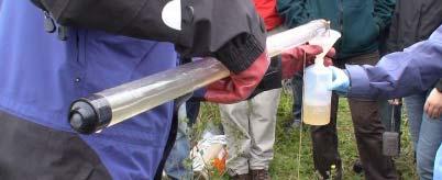
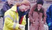
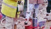
5 Hydrogeologists & Hydrologists In Action
6 Hydrogeology Concepts Hydrogeologists need to understand what is under the ground surface in Michigan to know more about groundwater supplies here. Michigan is underlain by thousands of feet of bedrock, but most drinking water supplies are found in the uppermost few hundred feet. Geologic storage locations holding water are termed aquifers.


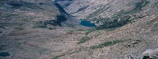


7 Glaciers Shaped Michigan s Surface Adapted from Charles Barker, 2005


8 Grand Canyon Rock Layer Thickness vs. Michigan Bedrock Thicknesses Layers of Rock of the Grand Canyon Layers of Rock Under Michigan Depth in Feet Below the Surface -0-1,000-2,000-3,000-4,000-5,000-6,000-7,000-8,000-9,000-10,000-11,000-12,000-13,000-14,000-15,000


9 Bedrock Layers Deposited Prior to Glaciation The bedrock of Michigan was deposited in a basin which h appears similar to as set of nested bowls. Modified from S. E. Wilson, 2006 Adapted from Olcott, 1992, and modified from Robinson, 2004
10 Hydrogeology Concepts Hydrogeologists study rocks and their properties to understand how water moves underground. These properties include: Consolidated vs. unconsolidated aquifer material Type and shape of the grains making up the aquifer How the material affects water flow Potential environments of deposition

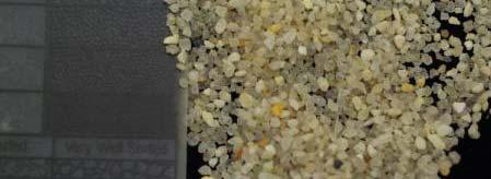
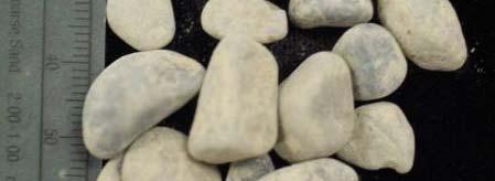
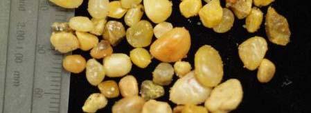


11 Some Examples of Unconsolidated Sediments Medium Sand Pebbles/Gravel Coarse Sand Clay Very Fine Sand Fine Sand Silt
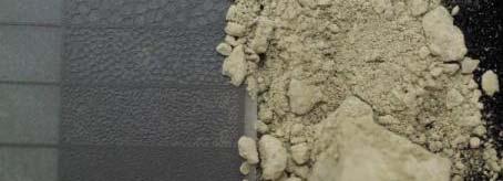
12 When unconsolidated sediments become lithified they are called Consolidated Sediments or Rocks Insert images from penn sandstones, etc. Sandstone Siltstone
13 Hydrogeology Concepts Porosity is the amount of space between the grains of sediment in unconsolidated or consolidated aquifer materials. The amount of pore space is determined by the shape, size, and sorting of the grains and any cements holding the grains together. The greater the pore space, the more porous the material is.


14 Sediment Grain Shape Analysis Tool From Jones & Jones, 2003 Grain roundness affects how sediments fit together when compacted or lithified. Sorting is a measure of the distribution of different sized sediments in a material. Poorly sorted sediments have grains of many different sizes present. Well-sorted sediments have grains of similar sizes. Larger grains may float in a matrix of smaller grains.
15 Hydrogeology Concepts When the pores of a material are connected together, water and other fluids can flow through the material. The more fluids that can pass through the pores, the more permeable a material is. Rocks are porous, but may not be considered permeable depending upon the characteristics of the pores and how they are connected.
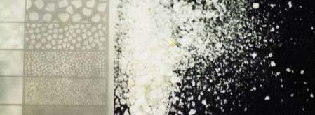
16 Sediment: Sand Rock: Sandstone
17 Hydrogeology Concepts Water stored in the pores of unconsolidated and consolidated material is affected by gravity and pressure. The water table level at any location is an example of these effects. Pollution is a major threat to the relatively shallow nature of the water table and unconfined aquifers in many parts of Michigan.
18 Hydrogeologic Vocabulary: From Jones & Jones, 2002 Zone of aeration is where pores are filled mostly with air. Zone of saturation is where pores are filled with fluids. Water table is the boundary between the two zones.
19 Hydrogeology Concepts In Michigan, aquifers in unconsolidated, glacial sediments are termed unconfined aquifers. Easier to access, shallower More prone to pollution Bedrock aquifers are usually confined, or bounded by other rock units that do not allow as much or any water to pass. May be harder to access, but less easily polluted If too deep may be briny


20 Glacial Sediments and Bedrock Aquifers Modified from W. R. Farrand, 1982 Modified from the Institute of Water Research, 1987


21 From Jones & Jones, 2002 From Jones & Jones, 2002 Unconfined Aquifer Hydrogeologic Vocabulary: Confined Aquifer Pumping wells affect the water in the pores of the aquifer surrounding them forming a cone of depression. In confined conditions, i water pressure from recharge in higher elevation areas can force wells to flow aboveground in lower-lying areas. These are called artesian wells or springs.
22 Hydrogeology Concepts Once hydrogeologists understand the aquifer material and the general geology of the area, they may assign an environment of deposition to the materials making up the aquifer. This understanding may give them clues about water quality, quantity, and availability.


23 Depositional Environment Affects Aquifers Example Deltaic deposits can be sandy or muddy and are home to many kinds of plants. Lithification turns sands to sandstone, and muds to mudstone and siltstone. The sandstones may be good water-bearing source rocks. The mudstones and siltstones may be barriers to water flow. Organic material trapped in the rocks from swampy areas may cause poor water quality from the release of gases from decayed vegetation.
24 Humans Contaminate Groundwater in Many Ways From Jones & Jones, 2003
25 Humans Contaminate Groundwater in Many Ways An illustration of salt-water encroachment, this can also occur in areas where deep bedrock aquifers are briny, like in Michigan s rock formations deposited from seas.
26 Exercise: Water Wells & Lithology Brought to you by Core Kids, WMU- MGRRE Geosciences K-12 Outreach Program Exercise created by Niah Venable, Amanda Walega and Susan Grammer with web content tb by Niah hv Venable A special thanks to 8 th grade teacher Becky Dalecki, Portage North Middle School and to the 8 th th grade science teachers and students t at Mattawan Middle School. With generous support from:
27 This exercise can be adapted for: High school students wishing to do an independent project using real data from their local area. Middle school students whose teachers can lead them through accessing data and constructing stratigraphic columns as a class according to the instructions on this website. Later elementary students who can use this exercise to visualize what is underground in their area.
28 Exercise Steps 1. Choose an area of interest (e.g. Charlotte, MI) 2. Find the corresponding topographic map 3. Find water well data from the area of interest 4. Interpret water well driller s logs 5C 5. Create lihl lithologic i columns 6. Calculate the Well Elevation 7. Create stratigraphic columns 8. Create cross-sections sections for comparison
29 1. Pick an Area of Interest For this example we will look at water wells around Charlotte, MI. Charlotte is located in Eaton County. First we need to get a topographic map of the area near Charlotte. This map will give us political and landform information such as section numbers and elevation contours for use in this project.


30 2. Find a Topo Map Browse to the State of Michigan, Department of Natural Resources homepage: From there browse to Publications and Maps, then Online Maps. Go to Topographic Quadrangles by Location. Use the dropdown list to find the county, in this case it is Eaton. A quick link to this page is: Click Download.


31 2. Find a Topo Map cont. The next screen shows s a green and yellow version of a political map with the locations of cities and towns with a blue grid overlay of the quadrangle names. Click on the quad labeled Charlotte in Eaton and Carmel townships.


32 2. Find a Topo Map cont. A pdf of the Charlotte quadrangle will open in Adobe Acrobat. We can save this and use as-is or copy and zoom to a portion of the map using MS Word or image handling software.


33 3. Find Water Well Data Browse to the State of Michigan, Department of Environmental Quality homepage: ihi From there click Water, then browse to Drinking Water, to Wt Water Well WllC Construction, ti then click on Scanned Water Well Record Retrieval System. A quick kli link to this page is: logs/


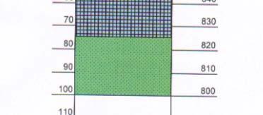
34 3. Find Water Well Data cont. The information used to find the topo and the map itself provide the county, township and section data we need to search the well retrieval database. We are interested in Eaton County so two searches need to be done by township, one for Eaton in sections 6, 18 and d19 19; and one for Carmel in sections 12, 13, and 24. We will omit section 7 of Et Eaton township, due to an absence of usable logs.

")


35 3. Find Water Well Data cont. After selecting the county, township(s) and section(s) of interest, we will be able to review a pdf file containing the scanned images of driller s reports from each area. The pdf driller s reports or logs will look like this. The number of logs available for each section varies.
36 4. Interpreting Driller s Logs The driller s log header contains well location information and often a hand-drawn drawn map with street names, which may prove useful flifh the quarter-quarter location information is not recorded, or recorded incorrectly.
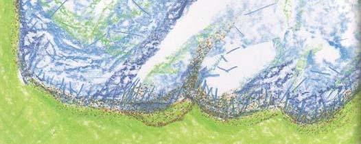
37 4. Interpreting Driller s Logs cont. The driller s log lithology information is listed by type of material, thickness of each unit, and total depth. The formation descriptions are more likely to be generic than scientific. The total drilled depth of this well is 100 feet bl below the surface.
38 4. Interpreting Driller s Logs cont. Other information provided by the driller s log is the owner of the well, the depth, the completion date and how the well was completed. It will also list possible sources of contamination, pump type, and who drilled the well. The static water level is equal to the depth to the water table, in this case it was encountered 36 feet below the surface.
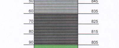
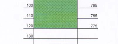
39 5. Creating Lithologic Columns Lithologic i or stratigraphic columns can be created from driller s logs using the formation descriptions provided by the driller and the depths to and the thicknesses of each unit. From 0-12 feet below the surface the driller encountered clay. From 12 to 16 feet below the surface they found sand. From 16 to 54 feet below the surface they found clay. From 54 to 60 feet below was gravel. From 60 to 100 feet below the surface they found sandrock, most likely the sandstones of the Saginaw Aquifer.
40 5. Creating Lithologic Columns cont. A basic form created in Excel is useful for plotting lithogy and other well information for viewing as a lithologic or stratigraphic column. The lithologic key can be modified depending on the type of earth material encountered in the wells.


41 5. Creating Lithologic Columns cont. Using the driller s log Hammond depths below the surface as a guide, we plot the lithologic l i types on the column with the lithologic key yp patterns and colors as fill. Next, we mark the water level l on the column using the symbol from the key.


42 6. Calculate the Well Elevation To calculate the well elevation values in feet above sea level and to convert the lithogic column to a stratigraphic column, we must first determine the well surface elevation. This is done using a topographic map since most of the driller s r reports do not provide well elevations.
43 6. Calculate the Well Elevation cont. Using the topo map of Charlotte and the location information provided in the driller s report we find that t the example well is located here. Contour lines in this area range between 910 feet and 920 feet above sea level. Interpolating the location between the two contours gives us a value of 918 feet above sea level.


44 6. Calculate the Well Elevation cont. We record the well elevation in the blank to the right. And then place the value on the top line of fth the scale on the right side of the lithology column. Next we subtract the depths in ten foot increments e from the elevation value until the bottom of the well is reached.
45 7. Create Multiple Strat Columns To compare the hydrogeology from several wells around the Charlotte area we must create more stratigraphic columns. Repeat steps 3 through 6 to create these columns. For this example we will use driller s logsfrom Eaton township, sections 18 and 19, and Carmel township, sections 12, 13, and 24. We will mark the locations of all the wells on the topo map for reference.


46 7. Multiple Strat Columns cont. Hammond All of the wells are now marked on the topographic p map for reference. Well elevation values have been picked from the map and used to convert the lithologic columns to stratigraphic columns. Mishler Porter Burt Archer City
47 7. Multiple Strat Columns cont. Once the stratigraphic columns are created, a depth datum is picked. The depth datum is used to compare the lithology and water levels in all wells at corresponding depths. Well Name and Elevation Range: Hammond: ft. Burt: ft. City: ft. Archer: ft. Porter: ft. Mischler: ft. The depth datum should be 880 feet above sea level l since all wells intersect that depth.


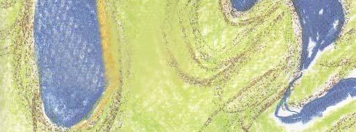
48 8. Cross-Section Creation The geographic area covered by the wells can be divided into two cross-sectional sectional lines running approximately North to South They are labeled A to A and B to B. A B A B


49 8. Cross Section Creation cont. The wells in each cross-section section can be compared by lining them up on the datum value. 880 ft. A A ~ 1.5 mi. ~ 1 mi.


50 8. Cross Section Creation cont. It is important to remember the distances between wells when making cross-sectional sectional comparisons. 880 ft. B B ~ 1.75 mi. ~ 2 mi.
51 9. Interpretation The cross-sections sections combined with the well locations on the topo map give a spatial comparison of the earth materials encountered at depth and how those materials vary over a distance between wells. The wells are about 1 to 2 miles apart and the relief between the highest and lowest wells is 55 feet. Static water levels range between a max elevation just under 900 ft. to just over 875 ft.
52 9. Interpretation cont. The glacial sediments found above the sandstone and shale bedrock in this area show variation in type and thickness from well to well, which is typical of these kinds of materials. Generally though, the glacial deposits in the A- A wells consist of clay and gravels, while the deposits in the B-B B wells are mainly sand and clay.
53 9. Interpretation cont. The Charlotte wells show no significant variation in static water levels. Dramatic variations in static water levels could be due to draw down effects in heavy-use areas. The sandstone and shale bedrock elevations vary by 60 ft for all wells, but for each cross section, the variation is between feet.
54 10. Summary Topographic maps and water well driller s logs can be used to examine the near-surface geology of Michigan. The driller s logs are also useful for determining depth to the water table, potential nearby contamination i hazards, and other information. i The data needed for these exercises is readily available on the internet from State of Michigan sources.
Groundwater Hydrology
 EXERCISE 12 Groundwater Hydrology INTRODUCTION Groundwater is an important component of the hydrologic cycle. It feeds lakes, rivers, wetlands, and reservoirs; it supplies water for domestic, municipal,
Geology and Natural Resources
 Geology and Natural Resources Brought to you by: Western Michigan University Department of Geosciences and The Michigan Geological Repository for Research and Education s K-12 Outreach Program Core Kids
EPS 50 - Lab 10: Groundwater Flow and Glaciers
 Name: EPS 50 - Lab 10: Groundwater Flow and Glaciers Part 1: Groundwater Flow Part 2: Darcy s Law Part 3: Glacial Deposits and Flow -Chapter 17, p. 478-492: Hydrology of Groundwater -Chapter 17, p. 485-486:
Follow this and additional works at: Part of the Geology Commons
 Western Michigan University ScholarWorks at WMU Michigan Geological Repository for Research and Education Geosciences 2016 Geology of Michigan William B. Harrison III Michigan Geological Repository for
How to Identify and Properly Classify Drill Cuttings
 How to Identify and Properly Classify Drill Cuttings (Creating Useful Borehole Logs) Dave Larson Hydrogeology and Geophysics Section Accurate information about the borehole location and a careful description
Land subsidence due to groundwater withdrawal in Hanoi, Vietnam
 Land Subsidence (Proceedings of the Fifth International Symposium on Land Subsidence, The Hague, October 1995). 1AHS Publ. no. 234, 1995. 55 Land subsidence due to groundwater withdrawal in Hanoi, Vietnam
Soils, Hydrogeology, and Aquifer Properties. Philip B. Bedient 2006 Rice University
 Soils, Hydrogeology, and Aquifer Properties Philip B. Bedient 2006 Rice University Charbeneau, 2000. Basin Hydrologic Cycle Global Water Supply Distribution 3% of earth s water is fresh - 97% oceans 1%
Chapter 13. Groundwater
 Chapter 13 Groundwater Introduction Groundwater is all subsurface water that completely fills the pores and other open spaces in rocks, sediments, and soil. Groundwater is responsible for forming beautiful
Lab 9: Petroleum and groundwater
 Geology 101 Name(s): Lab 9: Petroleum and groundwater Petroleum (oil) is a multi-component liquid refined to generate different hydrocarbons, such as heptane (a component of gasoline) and waxes. For the
RESISTIVITY IMAGING AND BOREHOLE INVESTIGATION OF THE BANTING AREA AQUIFER, SELANGOR, MALAYSIA. A.N. Ibrahim Z.Z.T. Harith M.N.M.
 JOURNAL OF ENVIRONMENTAL HYDROLOGY The Electronic Journal of the International Association for Environmental Hydrology On the World Wide Web at http://www.hydroweb.com VOLUME 11 2003 RESISTIVITY IMAGING
1 Water Beneath the Surface
 CHAPTER 16 1 Water Beneath the Surface SECTION Groundwater KEY IDEAS As you read this section, keep these questions in mind: What are two properties of aquifers? How is the water table related to the land
KANSAS GEOLOGICAL SURVEY Open File Report LAND SUBSIDENCE KIOWA COUNTY, KANSAS. May 2, 2007
 KANSAS GEOLOGICAL SURVEY Open File Report 2007-22 LAND SUBSIDENCE KIOWA COUNTY, KANSAS Prepared by Michael T. Dealy L.G., Manager, Wichita Operations SITE LOCATION The site was approximately four miles
FORENSIC GEOLOGY A CIVIL ACTION
 NAME 89.215 - FORENSIC GEOLOGY A CIVIL ACTION I. Introduction In 1982 a lawsuit was filed on behalf of eight Woburn families by Jan Schlictmann. The suit alleged that serious health effects (childhood
Prof. Stephen A. Nelson EENS 111. Groundwater
 Page 1 of 8 Prof. Stephen A. Nelson EENS 111 Tulane University Physical Geology This page last updated on 20-Oct-2003 is water that exists in the pore spaces and fractures in rock and sediment beneath
STUDY GUIDE FOR CONTENT MASTERY. Movement and Storage of Groundwater
 Groundwater SECTION 10.1 Movement and Storage of Groundwater In your textbook, read about the hydrosphere, precipitation and groundwater, and groundwater storage. Use the following terms to complete the
Surface Processes Focus on Mass Wasting (Chapter 10)
") Surface Processes Focus on Mass Wasting (Chapter 10) 1. What is the distinction between weathering, mass wasting, and erosion? 2. What is the controlling force in mass wasting? What force provides resistance?
Surface Processes Focus on Mass Wasting (Chapter 10) 1. What is the distinction between weathering, mass wasting, and erosion? 2. What is the controlling force in mass wasting? What force provides resistance?
Groundwater. (x 1000 km 3 /y) Reservoirs. Oceans Cover >70% of Surface. Groundwater and the. Hydrologic Cycle
 Reservoirs. Oceans Cover >70% of Surface. Groundwater and the. Hydrologic Cycle") Chapter 13 Oceans Cover >70% of Surface Groundwater and the Hydrologic Cycle Oceans are only 0.025% of Mass Groundwater Groundwater is liquid water that lies in the subsurface in fractures in rocks and
Chapter 13 Oceans Cover >70% of Surface Groundwater and the Hydrologic Cycle Oceans are only 0.025% of Mass Groundwater Groundwater is liquid water that lies in the subsurface in fractures in rocks and
Finding Large Capacity Groundwater Supplies for Irrigation
 Finding Large Capacity Groundwater Supplies for Irrigation December 14, 2012 Presented by: Michael L. Chapman, Jr., PG Irrigation Well Site Evaluation Background Investigation Identify Hydrogeologic Conditions
ADVENTURES IN WATER DEVELOPED BY LOUISVILLE WATER COMPANY
 ADVENTURES IN WATER DEVELOPED BY LOUISVILLE WATER COMPANY Tunneling for Water explains the science behind a first-of-its-kind project in the world! Louisville Water Company is the first water utility
11/22/2010. Groundwater in Unconsolidated Deposits. Alluvial (fluvial) deposits. - consist of gravel, sand, silt and clay
 deposits. - consist of gravel, sand, silt and clay") Groundwater in Unconsolidated Deposits Alluvial (fluvial) deposits - consist of gravel, sand, silt and clay - laid down by physical processes in rivers and flood plains - major sources for water supplies
Groundwater in Unconsolidated Deposits Alluvial (fluvial) deposits - consist of gravel, sand, silt and clay - laid down by physical processes in rivers and flood plains - major sources for water supplies
Section 3. Slopes and Landscapes. What Do You See? Think About It. Investigate. Learning Outcomes
 Chapter 4 Surface Processes Section 3 Slopes and Landscapes What Do You See? Learning Outcomes In this section, you will Calculate the angle of repose for different kinds of soils and other granular materials.
RIVERS, GROUNDWATER, AND GLACIERS
 RIVERS, GROUNDWATER, AND GLACIERS Delta A fan-shaped deposit that forms when a river flows into a quiet or large body of water, such as a lake, an ocean, or an inland sea. Alluvial Fan A sloping triangle
How Do Geology and Physical Streambed Characteristics Affect Water Quality?
 Teacher s Guide How Do Geology and Physical Streambed Characteristics Affect Water Quality? Lesson Description In this lesson, the students research a dynamic, vertical dimension of a watershed - the geological
PDF HOW DO CLASTIC SEDIMENTARY ROCKS FORM EBOOK
 06 February, 2018 PDF HOW DO CLASTIC SEDIMENTARY ROCKS FORM EBOOK Document Filetype: PDF 457.68 KB 0 PDF HOW DO CLASTIC SEDIMENTARY ROCKS FORM EBOOK The rock fragments that form clastic sedimentary rocks
Structure contours on Bone Spring Formation (Lower Permian), Delaware Basin
, Delaware Basin") Structure contours on Bone Spring Formation (Lower Permian), Delaware Basin By Ronald F. Broadhead and Lewis Gillard New Mexico Bureau of Geology and Mineral Resources, a division of New Mexico Tech, Socorro
Structure contours on Bone Spring Formation (Lower Permian), Delaware Basin By Ronald F. Broadhead and Lewis Gillard New Mexico Bureau of Geology and Mineral Resources, a division of New Mexico Tech, Socorro
Connecticut's Aquifers
 Page 1 of 5 DEP Search: Connecticut's Aquifers The technical definition of the word "aquifer" is: any geologic formation capable of yielding significant quantities of water to wells. By that definition,
Essentials of Geology, 11e
 Essentials of Geology, 11e Groundwater Chapter 10 Instructor Jennifer Barson Spokane Falls Community College Geology 101 Stanley Hatfield Southwestern Illinois Co Jennifer Cole Northeastern University
Sediment and sedimentary rocks Sediment
 Sediment and sedimentary rocks Sediment From sediments to sedimentary rocks (transportation, deposition, preservation and lithification) Types of sedimentary rocks (clastic, chemical and organic) Sedimentary
GEOL.3250 Geology for Engineers Glacial Geology
 GEOL.3250 Geology for Engineers Glacial Geology NAME Part I: Continental Glaciation Continental glaciers are large ice sheets that cover substantial portions of the land area. In the region of accumulation
Seismic Reflection Imaging across the Johnson Ranch, Valley County, Idaho
 Seismic Reflection Imaging across the Johnson Ranch, Valley County, Idaho Report Prepared for the Skyline Corporation Lee M. Liberty Center for Geophysical Investigation of the Shallow Subsurface (CGISS)
A method for three-dimensional mapping, merging geologic interpretation, and GIS computation
 A method for three-dimensional mapping, merging geologic interpretation, and GIS computation Soller, David R., U.S. Geological Survey, 908 National Center, Reston, VA 20192 and Richard C. Berg, Illinois
EPS 50 Lab 4: Sedimentary Rocks
 Name: EPS 50 Lab 4: Sedimentary Rocks Grotzinger and Jordan, Chapter 5 Introduction In this lab we will classify sedimentary rocks and investigate the relationship between environmental conditions and
What is a water table? What is an aquifer? What is the difference between a spring and a well?
 CHAPTER 11 3 Water Underground SECTION The Flow of Fresh Water BEFORE YOU READ After you read this section, you should be able to answer these questions: What is a water table? What is an aquifer? What
Chapter 14. Groundwater
 Chapter 14 Groundwater Importance of groundwater! Groundwater is water found in the pores of soil and sediment, plus narrow fractures in bedrock! Groundwater is the largest reservoir of fresh water that
Tim Carr - West Virginia University
 Tim Carr - West Virginia University Exploration s Ultimate Goal is to Answer Four Questions: Where to Drill? What to Expect? How Certain? How Profitable? Location & Depth HC Volumes Chance of Success
5. Which surface soil type has the slowest permeability rate and is most likely to produce flooding? A) pebbles B) sand C) silt D) clay A) B) C) D)
 pebbles B) sand C) silt D) clay A) B) C) D)") 1. During a heavy rainstorm, soil samples A and B both became saturated with water. However, 10 minutes after the storm ended, the soils appeared as shown below. Which statement best explains the observed
1. During a heavy rainstorm, soil samples A and B both became saturated with water. However, 10 minutes after the storm ended, the soils appeared as shown below. Which statement best explains the observed
A Standardized Digital Well-Record Database for the Glaciated U.S.
 A Standardized Digital Well-Record Database for the Glaciated U.S. Randy Bayless and Les Arihood U.S. Geological Survey, Indiana Water Science Center, Indianapolis, IN Howard Reeves U.S. Geological Survey,
Groundwater. (x 1000 km 3 /y) Oceans Cover >70% of Surface. Groundwater and the. Hydrologic Cycle
 Oceans Cover >70% of Surface. Groundwater and the. Hydrologic Cycle") Chapter 17 Oceans Cover >70% of Surface Groundwater and the Hydrologic Cycle Vasey s Paradise, GCNP Oceans are only 0.025% of Mass Groundwater Groundwater is liquid water that lies in the subsurface in
Chapter 17 Oceans Cover >70% of Surface Groundwater and the Hydrologic Cycle Vasey s Paradise, GCNP Oceans are only 0.025% of Mass Groundwater Groundwater is liquid water that lies in the subsurface in
To get you thinking Explain how these different layers of rock formed? Why are these layers different colors? Sedimentary Rocks
 To get you thinking Explain how these different layers of rock formed? Why are these layers different colors? Sedimentary Rocks Bryce Canyon, Utah Badlands, South Dakota Weathering Whenever rock is exposed
Geology 101, Spring 2008
 Geology 101, Spring 2008 Name(s): Lab 10: Groundwater and resource extraction Groundwater As many parts of the world are becoming increasingly aware, groundwater is an economic resource, as strategic and
Geology 103 Planet Earth (QR II), Laboratory Exercises 1. Groundwater
, Laboratory Exercises 1. Groundwater") Geology 103 Planet Earth (QR II), Laboratory Exercises 1 Student Name: Section: Karst Landform: Groundwater Anyone who has viewed Chinese landscape scroll paintings will recognize that the mountains are
Geology 103 Planet Earth (QR II), Laboratory Exercises 1 Student Name: Section: Karst Landform: Groundwater Anyone who has viewed Chinese landscape scroll paintings will recognize that the mountains are
NC Earth Science Essential Standards
 NC Earth Science Essential Standards EEn. 2.1 Explain how processes and forces affect the Lithosphere. EEn. 2.1.1 Explain how the rock cycle, plate tectonics, volcanoes, and earthquakes impact the Lithosphere.
Section I: Multiple Choice Select the best answer to each question. Mark your final answer on the answer sheet. (1 pt each)
") Sedimentary Rocks & Surface Processes Quest Name: Earth Science 2013 Block: Date: Section I: Multiple Choice Select the best answer to each question. Mark your final answer on the answer sheet. (1 pt each)
Sedimentary Rocks & Surface Processes Quest Name: Earth Science 2013 Block: Date: Section I: Multiple Choice Select the best answer to each question. Mark your final answer on the answer sheet. (1 pt each)
Evolution of the conceptual hydrogeologic and ground-water flow model for Las Vegas Valley, Clark County, Nevada
 Evolution of the conceptual hydrogeologic and ground-water flow model for Las Vegas Valley, Clark County, Nevada Geological Society of America Annual Meeting November 14, 2 David J. Donovan Southern Nevada
Ground-Water Exploration in the Worthington Area of Nobles County: Summary of Seismic Data and Recent Test Drilling Results
 Ground-Water Exploration in the Worthington Area of Nobles County: Summary of Seismic Data and Recent Test Drilling Results Jim Berg and Todd Petersen Geophysicists, DNR Waters January 2000 Table of Contents
Reservoirs and Production
 Lesson Plan Page 1 Topic: Reservoirs and production Topic Overview: Porosity refers to the percentage of holes (pores) in the rock. Permeability is the ability of fluids to travel through porous rocks.
Airborne Geophysics to Map Groundwater. Bill Brown
 Airborne Geophysics to Map Groundwater Bill Brown bb@skytem.com A 6 borehole represents 1 millionth of an acre Aquifer Materials An aquifer is an underground layer of water bearing permeable rock, rock
UNIT 4: Earth Science Chapter 21: Earth s Changing Surface (pages )
") CORNELL NOTES Directions: You must create a minimum of 5 questions in this column per page (average). Use these to study your notes and prepare for tests and quizzes. Notes will be turned in to your teacher
CORNELL NOTES Directions: You must create a minimum of 5 questions in this column per page (average). Use these to study your notes and prepare for tests and quizzes. Notes will be turned in to your teacher
GEOL 380: Earthquake Hazards in the Puget Sound Region (in class and assignment) Due in class Wednesday, Nov 109th
 Due in class Wednesday, Nov 109th") GEOL 380: Earthquake Hazards in the Puget Sound Region (in class and assignment) Due in class Wednesday, Nov 109th The purpose of this exercise/assignment is for you to gain practice and experience in
GEOL 380: Earthquake Hazards in the Puget Sound Region (in class and assignment) Due in class Wednesday, Nov 109th The purpose of this exercise/assignment is for you to gain practice and experience in
Core Description, Stratigraphic Correlation, and Mapping of Pennsylvanian Strata in the Appalachians
 Core Description, Stratigraphic Correlation, and Mapping of Pennsylvanian Strata in the Appalachians The remaining laboratory sessions for the semester will be collected into a series of exercises designed
Chapter 14: Groundwater. Fig 14.5b
 Chapter 14: Groundwater Fig 14.5b OBJECTIVES Recognize that groundwater is a vital source of accessible freshwater. Describe how groundwater forms below the water table. Explain the origin of aquifers,
Mark S. Nordberg Geology and Groundwater Investigations Section North Central Region Office California Department of Water Resources
 Mark S. Nordberg Geology and Groundwater Investigations Section North Central Region Office California Department of Water Resources Ukiah Drought Workshop July 29, 2009 Groundwater 101 Groundwater is
Land and Water Study Guide
 Land and Water Study Guide Answer Key Part 1 States of Matter 1. What are the three states of matter for water? Give several examples for each. Solid Ice cube (non water examples = candy bar and a log).
Lecture Outline Wednesday - Friday February 14-16, 2018
 Lecture Outline Wednesday - Friday February 14-16, 2018 Quiz 2 scheduled for Friday Feb 23 (Interlude B, Chapters 6,7) Questions? Chapter 6 Pages of the Past: Sedimentary Rocks Key Points for today Be
elevationgain # lateral distan ce&
 Geology 101 Name(s): Lab 9: Streams and floods Geomorphology is the study of the way in which the environment is continually reshaping the Puget Sound (and the world's) landscape. Running water is a major
' International Institute for Land Reclamation and Improvement. 2 Groundwater Investigations. N.A. de Ridder'? 2.1 Introduction. 2.
 2 Groundwater Investigations N.A. de Ridder'? 2.1 Introduction Successful drainage depends largely on a proper diagnosis of the causes of the excess water. For this diagnosis, one must consider: climate,
UNIT 4 SEDIMENTARY ROCKS
 UNIT 4 SEDIMENTARY ROCKS WHAT ARE SEDIMENTS Sediments are loose Earth materials (unconsolidated materials) such as sand which are transported by the action of water, wind, glacial ice and gravity. These
C) D) 3. Which graph best represents the relationship between soil particle size and the rate at which water infiltrates permeable soil?
 D) 3. Which graph best represents the relationship between soil particle size and the rate at which water infiltrates permeable soil?") 1. Which earth material covering the surface of a landfill would permit the least amount of rainwater to infiltrate the surface? A) silt B) clay C) sand D) pebbles 2. Which graph best represents the relationship
1. Which earth material covering the surface of a landfill would permit the least amount of rainwater to infiltrate the surface? A) silt B) clay C) sand D) pebbles 2. Which graph best represents the relationship
Evaluation of Subsurface Formation of Pabna District, Bangladesh
 IOSR Journal of Applied Geology and Geophysics (IOSR-JAGG) e-issn: 2321 0990, p-issn: 2321 0982.Volume 1, Issue 4 (Sep. Oct. 2013), PP 30-36 Evaluation of Subsurface Formation of Pabna District, Bangladesh
,Baynes Lake. TO...?&.?...A 2...KO.?'!!&... Sr. *logical Engineer
 > i evernment OF BRITISH COLUMBIA a TO...?&.?...A 2....KO.?'!!&... Sr. *logical Engineer... Grou,,water. Section Hydrology Division Wat.er... In~.~s.tiga.ti.On.s..Branck.... 5 u BJECT...C;.roun.dw.ater...Snve
Hydrogeological Assessment for Part of Lots 2 and 3, Concession 5, Township of Thurlow, County of Hastings 1.0 INTRODUCTION. 1.
 February 10,2017 25506400 Ontario Ltd. Foxboro, ON Attention: Brad Newbatt Re: Hydrogeological Assessment for Part of Lots 2 and 3, Concession 5, Township of Thurlow, County of Hastings 1.0 INTRODUCTION
3. Based on your observations on the questions above, circle the characteristics of a good sediment for an aquifer:
 Geology 101 Name(s): Lab 10: Groundwater and petroleum Groundwater As many parts of the world are becoming increasingly aware, groundwater is an economic resource, as strategic and necessary as petroleum
Florida s Karst Geology
 Florida s Karst Geology Orange Creek Basin Interagency Working Group Public Workshop, November 5 th, 2015 Harley Means, P.G. Assistant State Geologist Florida Geological Survey Karst Karst a type of topography
WATER ON AND UNDER GROUND. Objectives. The Hydrologic Cycle
 WATER ON AND UNDER GROUND Objectives Define and describe the hydrologic cycle. Identify the basic characteristics of streams. Define drainage basin. Describe how floods occur and what factors may make
HYDROGEOLOGICAL PROPERTIES OF THE UG2 PYROXENITE AQUIFERS OF THE BUSHVELD COMPLEX
 R. Gebrekristos, P.Cheshire HYDROGEOLOGICAL PROPERTIES OF THE UG2 PYROXENITE AQUIFERS OF THE BUSHVELD COMPLEX R. Gebrekristos Digby Wells Environmental P. Cheshire Groundwater Monitoring Services Abstract
Structure contours on Abo Formation (Lower Permian) Northwest Shelf of Permian Basin
 Northwest Shelf of Permian Basin") Structure contours on Abo Formation (Lower Permian) Northwest Shelf of Permian Basin By Ronald F. Broadhead 1, Lewis Gillard 1, and Nilay Engin 2 1 New Mexico Bureau of Geology and Mineral Resources, a
Structure contours on Abo Formation (Lower Permian) Northwest Shelf of Permian Basin By Ronald F. Broadhead 1, Lewis Gillard 1, and Nilay Engin 2 1 New Mexico Bureau of Geology and Mineral Resources, a
Dave Barnes Department of Geosciences Western Michigan University 1903 W. Michigan Ave. Kalamazoo, MI,
 Subsurface Techniques in Stratigraphic Analysis: The Berea Sandstone in the Williams Oil Field, Bay and Midland Co., MI; Log Correlation; Stratigraphic Cross Sections; Structure, Lithology and Facies Mapping
Sediment. Weathering: mechanical and chemical decomposition and disintegration of rock and minerals at the surface
 Sediment Some basic terminology Weathering: mechanical and chemical decomposition and disintegration of rock and minerals at the surface Erosion: removal of weathered rock and minerals from one place to
Chapter 6 Pages of Earth s Past: Sedimentary Rocks
 Chapter 6 Pages of Earth s Past: Sedimentary Rocks Introduction! Drilling into the bottom of the North Sea, we encounter: " Soft mud and loose sand, silt, pebbles, and shells. Then: " Similar materials
THE HOUSTON MUSEUM OF NATURAL SCIENCE ONLINE CURRICULUM WIESS ENERGY HALL 3 RD GRADE 5 TH GRADE GENEROUSLY SUPPORTED BY PWC
 THE HOUSTON MUSEUM OF NATURAL SCIENCE ONLINE CURRICULUM WIESS ENERGY HALL 3 RD GRADE 5 TH GRADE GENEROUSLY SUPPORTED BY PWC Dear Educator, Thank you for downloading the free, online curriculum available
Name: KEY OBJECTIVES HYDROLOGY:
 Name: KEY OBJECTIVES Correctly define: abrasion, capillarity, deposition, discharge, erosion, evapotranspiration, hydrology, impermeable, infiltration, meander, permeable, porosity, water table, weathering,
Chapter 8 Fetter, Applied Hydrology 4 th Edition, Geology of Groundwater Occurrence
 Chapter 8 Fetter, Applied Hydrology 4 th Edition, 2001 Geology of Groundwater Occurrence Figure 8.42. Alluvial Valleys ground-water region. Fetter, Applied Hydrology 4 th Edition, 2001 Fetter, Applied
The Niagara Escarpment extends from western New York, through the GTA all the way up to Manitoulin Island and into Michigan and Wisconsin.
 is southern Ontario s most prominent topographic feature, extending more than 500 kilometres from western New York, through Niagara Falls and the western part of the Greater Toronto Area (GTA), and north
Geology 252, Historical Geology, California State University, Los Angeles - professor: Dr. Alessandro Grippo
 LAB # 1 - CLASTIC ROCKS Background: - Mechanical and Chemical Weathering - Production of Clastic Sediment - Classification of Sediment according to size: Gravel, Sand, Silt, Clay - Erosion, Transportation
Pre-Lab Reading Questions ES202
 ES202 The are designed to encourage students to read lab material prior to attending class during any given week. Reading the weekly lab prior to attending class will result in better grade performance
Your web browser (Safari 7) is out of date. For more security, comfort and. the best experience on this site: Update your browser Ignore
 is out of date. For more security, comfort and. the best experience on this site: Update your browser Ignore") Your web browser (Safari 7) is out of date. For more security, comfort and Activitydevelop the best experience on this site: Update your browser Ignore Extracting Gas from Shale How is natural gas extracted
Your web browser (Safari 7) is out of date. For more security, comfort and Activitydevelop the best experience on this site: Update your browser Ignore Extracting Gas from Shale How is natural gas extracted
Wisconsin s Hydrogeology: an overview
 2012 Soil and Water Conservation Society Conference Stevens Point, WI Feb 9, 2012 Wisconsin s Hydrogeology: an overview Ken Bradbury Wisconsin Geological and Natural History Survey University of Wisconsin-Extension
Reservoirs and Production
 Lesson Plan - Page 1 Topic Reservoirs and Production Source Oil and Natural Gas, pages 24-25, 26-27 Objective The students will learn that porosity refers to the percentage of holes (pores) in the rock.
Our File: 92 F/1, 92 F/8. Numerous licenced springs occur north of the B.C. Hydro right-of-way on. Water Management Branch
 J.C. Foweraker, Head Groundwater Section Water Management Branch Date: May 23, 1986 Our File: 92 F/1, 92 F/8 Re: Groundwater - D.L. 117. Nanoose District As requested by Mr. B. Hollingshead, Regional Water
13. Sedimentary Rocks I (p )
") 13. Sedimentary Rocks I (p. 194-208) Sediment Deposition Weathering results in rock being broken down into smaller fragments, called regolith. This regolith is then broken down to form soil. The regolith
13. Sedimentary Rocks I (p. 194-208) Sediment Deposition Weathering results in rock being broken down into smaller fragments, called regolith. This regolith is then broken down to form soil. The regolith
Geophysical Surveys for Groundwater Modelling of Coastal Golf Courses
 1 Geophysical Surveys for Groundwater Modelling of Coastal Golf Courses C. RICHARD BATES and RUTH ROBINSON Sedimentary Systems Research Group, University of St. Andrews, St. Andrews, Scotland Abstract
Groundwater in Bayfield County
 Groundwater in Bayfield County Presented to Bayfield County Large Scale Livestoc Study Committee April 23, 2015 Madeline Gotowitz Hydrogeologist Groundwater in Bayfield County Groundwater basics Hydrogeology
Cuyama Basin North Fork Vineyard
 Cuyama Basin North Fork Vineyard Company Background plus Data Insights to Support GSP Development for the Cuyama Basin Presented by Grapevine Capital Partners and Cleath-Harris Geologists April 26th, 2018
Procedure for Determining Near-Surface Pollution Sensitivity
 Procedure for Determining Near-Surface Pollution Sensitivity Minnesota Department of Natural Resources Division of Ecological and Water Resources County Geologic Atlas Program March 2014 Version 2.1 I.
AWRA PMAS Engineers Club of Philadelphia. A Geologic Perspective on Stormwater
 AWRA PMAS Engineers Club of Philadelphia A Geologic Perspective on Stormwater Toby J. Kessler, P.G. Hydrogeologist Trevor G. Woodward, P.G. Engineering Geologist September 10, 2014 Gilmore & Associates,
Biosphere. All living things, plants, animals, (even you!) are part of the zone of the earth called the biosphere.
 are part of the zone of the earth called the biosphere.") Unit 1 Study Guide Earth s Spheres Biosphere All living things, plants, animals, (even you!) are part of the zone of the earth called the biosphere. Hydrosphere Water covers ¾ of the earth, made up mostly
Unit 1 Study Guide Earth s Spheres Biosphere All living things, plants, animals, (even you!) are part of the zone of the earth called the biosphere. Hydrosphere Water covers ¾ of the earth, made up mostly
Sedimentary Rocks. Origin, Properties and Identification. Geology Laboratory GEOL 101 Lab Ray Rector - Instructor
 Sedimentary Rocks Origin, Properties and Identification Geology Laboratory GEOL 101 Lab Ray Rector - Instructor Sedimentary Rock Origin and Identification Lab Pre-Lab Internet Link Resources 1) http://www.rockhounds.com/rockshop/rockkey/index.html
WESTCARB Phase I Results Review
 WESTCARB Phase I Results Review Arizona Geologic Characterization Errol Montgomery Principal Errol L. Montgomery & Associates (520) 881-4912 emontgomery@elmontgomery.com November 9, 2005 Site Characterization
Lab 7: Sedimentary Structures
 Name: Lab 7: Sedimentary Structures Sedimentary rocks account for a negligibly small fraction of Earth s mass, yet they are commonly encountered because the processes that form them are ubiquitous in the
Section 11.1 pp Where Mountains Form
 Section 11.1 pp. 236 237 Where Mountains Form Chapter 11 Set a Purpose: TE, p. 236 Reading Study Guide, p. 36 Discussion: TE, p. 236 Differentiating ion Reading Support: TE, p. 236 Visual Teaching Interpret
Geologic Mapping Regional Tournament Trial Event
 Geologic Mapping Regional Tournament Trial Event A TEAM OF UP TO: 2 Team Name AVAILABLE TIME: 50 min Required Materials: Each team MUST have a protractor, ruler, non-programmable calculator, colored pencils,
Sedimentary Rocks. Origin, Properties and Identification. Physical Geology GEOL 100. Ray Rector - Instructor
 Sedimentary Rocks Origin, Properties and Identification Physical Geology GEOL 100 Ray Rector - Instructor Sedimentary Rock Origin and Identification Lab Pre-Lab Internet Link Resources 1) http://www.rockhounds.com/rockshop/rockkey/index.html
P.R. SPRING AND HILL CREEK TAR SAND AREAS A RESOURCE ASSESSMENT (IN PROGRESS)
") P.R. SPRING AND HILL CREEK TAR SAND AREAS A RESOURCE ASSESSMENT (IN PROGRESS) presented by WALLY GWYNN - Utah Geological Survey at the Western U.S. Oil Sands Technology Transfer Meeting February 22, 2008
P.R. SPRING AND HILL CREEK TAR SAND AREAS A RESOURCE ASSESSMENT (IN PROGRESS) presented by WALLY GWYNN - Utah Geological Survey at the Western U.S. Oil Sands Technology Transfer Meeting February 22, 2008
Mapping Earth. How are Earth s surface features measured and modeled?
 Name Mapping Earth How are Earth s surface features measured and modeled? Before You Read Before you read the chapter, think about what you know about maps Record your thoughts in the first column Pair
STUDY GUIDE FOR CONTENT MASTERY. Surface Water Movement
 Surface Water SECTION 9.1 Surface Water Movement In your textbook, read about surface water and the way in which it moves sediment. Complete each statement. 1. An excessive amount of water flowing downslope
GLG Chapter 7 Sedimentary Environments & Rocks
 GLG 101 - Chapter 7 Sedimentary Environments & Rocks Name Note, Oct 11: I ll be writing this study sheet over the next few days. Each day I will add questions until the entire chapter is done, hopefully
ENVIRONMENTAL EFFECTS OF GROUNDWATER WITHDRAWAL IN SOUTH NYÍRSÉG
 PhD thesis ENVIRONMENTAL EFFECTS OF GROUNDWATER WITHDRAWAL IN SOUTH NYÍRSÉG János Szanyi Szeged, 2004 ENVIRONMENTAL EFFECTS OF GROUNDWATER WITHDRAWAL IN SOUTH NYÍRSÉG Preliminaries, the aims of the dissertation
GEOLOGICAL LOG INTERPRETATION TUTORIAL
 GEOLOGICAL LOG INTERPRETATION TUTORIAL Text and Figures by Geoff Bohling and John Doveton The following pages will familiarize you with the basics of the geological interpretation of common logs as they
SECTION 4 TABLES. 1 Summary of Hydrogeologic Parameters for Various Stratigraphic Units FIGURES
 SECTION 4 4.0 OVERVIEW OF GEOLOGY AND HYDROGEOLOGY... 13 4.1 Comparison of East and West Sides of Study Area... 15 4.2 Bedrock Sequence... 17 4.3 Mancos Shale (Upper Cretaceous)... 18 4.4 Mesaverde Formation
 12 10 8 6 4 2 0 40-50 50-60 60-70 70-80 80-90 90-100 Fresh Water What we will cover The Hydrologic Cycle River systems Floods Groundwater Caves and Karst Topography Hot springs Distribution of water in