SECTION 4 TABLES. 1 Summary of Hydrogeologic Parameters for Various Stratigraphic Units FIGURES
|
|
|
- Louise Parks
- 5 years ago
- Views:
Transcription
1 SECTION OVERVIEW OF GEOLOGY AND HYDROGEOLOGY Comparison of East and West Sides of Study Area Bedrock Sequence Mancos Shale (Upper Cretaceous) Mesaverde Formation (Upper Cretaceous) Cozette Member (Upper Cretaceous) Rollins Sandstone Member (Upper Cretaceous) Coal-Bearing Member Sandstones Coal Seams Burned Zones in the Coal-Bearing Member Barren Member of the Mesaverde Formation (Upper Cretaceous) Ohio Creek Member of the Mesaverde Formation (Upper Cretaceous) Wasatch Formation (Tertiary) Green River Formation (Eocene) Uinta Formation (Eocene) Basalt Dikes, Dike-like Bodies and Sills Basalt Flows Unconsolidated Deposits Geology Hydrogeology of Unconsolidated Deposits Faults and Fractures TABLES 1 Summary of Hydrogeologic Parameters for Various Stratigraphic Units FIGURES 3 Schematic Cross Section South Flank of Grand Mesa Color Shaded Relief Image of Study Area... 16
2 4.0 OVERVIEW OF GEOLOGY AND HYDROGEOLOGY The hydrogeologic characteristics of the rock units that occur in the Grand Mesa, Cedaredge and Paonia areas directly control the movement of groundwater and the interaction of groundwater and surface water in the study area. Different authors cite slightly different thicknesses for the units. This report, for the most part, uses USGS figures (Brooks 1983) and the geologic maps prepared by C. Richard Dunrud, P.E. and other USGS staff (USGS Coal Investigations Maps C- 115 and 116 [Dunrud 1989a, 1989b], Map C-109 [Dunrud 1987] and Map C-97A [Ellis and Freeman 1984]). The descriptions below are based on the literature cited at the back of this report, coupled with the observations of Messrs. Dunrud and Rold and WWE staff. Exhibit 4 provides a geologic map of the study area, as published by the USGS. Figure 3 is a simplified schematic geologic cross section, while Exhibits 5 & 6 provide detailed geologic cross sections, the locations of which appear on Exhibit 4. The detailed geologic cross sections provided as Exhibits 5 and 6 demonstrate the stratigraphic relationship between bedrock formations. The east/west section (Exhibit 5) located on a line north of Cedaredge provides sub-surface details including fault offsets and lithologic changes between the numerous coal resource test holes used to create the cross section. These wells and their associated lithologies were extracted from information compiled by Dunrud (1989a, 1989b). Exhibit 6 (the north/south section) provides a scaled version of Figure 3. This exhibit shows the downward dip, or tilt, of the bedrock formations in comparison to the increasing elevation towards the north. Throughout the discussion that follows, the west side of the study area is used in reference to the vicinity of Cedaredge, while the east side of the study area is used in reference to the vicinity of Paonia Reservoir Wright Water Engineers Page 13
3
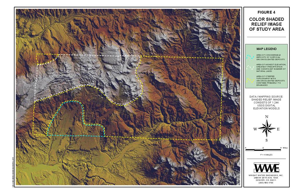
4 4.1 Comparison of East and West Sides of Study Area It is important to recognize that there are topographic, hydrologic and shallow hydrogeologic differences from the east side of the study area (roughly Paonia Reservoir) to the west side (roughly Cedaredge), as noted in various documents. Brooks (1983) states that: A greater area of bedrock in the Cedaredge study area is overlain by thick, unconsolidated Quaternary deposits than in the Paonia area. This is due to the differences in topography of the two areas. The Cedaredge study area in western Delta County is rugged, but not nearly as steep as the Paonia study area in the eastern part of the county. The steeper slopes and greater stream gradients in eastern Delta County create a greater potential for sediment transport in streams, resulting in the erosion of surficial deposits from local valley walls and cliff fronts facing the North Fork of the Gunnison River, and exposure of the underlying bedrock... The Mesaverde Formation and overlying unconsolidated Quaternary deposits are more saturated in the Cedaredge study area than in the Paonia study area. Mr. Bruce Bertram also describes these differences in his June 2002 report as follows: There is a significant difference in the existing surface terrain (topography) between the eastern project area near Paonia and the western project area near Cedaredge. The valleys narrow and are surrounded by very steep slopes in the eastern area and contain few if any of the outwash alluvium terraces that begin to dominate the lower slopes of the Grand Mesa toward the west. Specific recognizable terraces are: (among others) Pitkin Mesa, Hanson Mesa, Rogers Mesa, Redlands Mesa, Cedar Mesa, and numerous smaller mesas (having minimal alluvium caps) around the Cedaredge area. The significant difference at Cedaredge is the entire Surface Creek Valley is for the most part a large outwash of alluvium beginning high in the scrub oak and lower aspen levels of the Grand Mesa tapering out but not disappearing until reaching the Gunnison River. There are increased occurrences of springs and successful shallow (most less than 300 ft) water wells in areas covered with the outwash alluvium. Figure 4 graphically represents the differences in surface topography across the study area by use of a colored-shaded relief image. Although the surficial characteristics differ across the study area, there is relatively little difference in the hydrogeology of the bedrock formations as discussed in the sections which follow Wright Water Engineers Page 15
5
6 4.2 Bedrock Sequence The discussion that follows generally describes the geologic and hydrogeologic conditions in terms of the Cedaredge area, which includes the general vicinity of the Town of Cedaredge in the western side of the study area, and the Paonia Reservoir area in the eastern side of the study area. The overall study area is located along the southern edge (and southeastern part) of the Piceance Basin (Hettinger and Kirschbaum 2002). The bedrock, as measured on top of the Rollins Sandstone (Dunrud 1989a; Dunrud 1989b, based on structural contours), dips northward at 2.5 to 3.5 degrees in the Paonia Reservoir area and 2.5 to 4.5 degrees in the Cedaredge area. Faults and fractures that occur in the study area are discussed in Section The bedrock from the Paonia Reservoir area (including the Upper West Muddy Creek area) to the Cedaredge area (including the Hells Kitchen-Grand Mesa areas) ranges from Cretaceous to Tertiary in age. Described from oldest to youngest (ascending order), the bedrock consists of the following (please also refer to Exhibits 5 & 6 for geologic cross sections, which are shown on Exhibit 4, Geologic Map of Study Area): 1. Mancos Shale, with a total thickness of as much as 5,000 feet. 2. Sandstones, mudstones, and claystones of the Mesaverde Formation, which ranges in thickness from about 2,400 to 2,800 feet (excluding the Cozette Member present in the Cedaredge area) to as much as 3,200 feet thick beneath Grand Mesa, which includes the Cozette Member and a tongue of Mancos Shale. 3. Claystone, siltstone, and sandstone of the Wasatch Formation, 1,000 to 2,500 feet thick. 4. Marlstone, oil shale, siltstone and sandstone of the Green River Formation, about 1,000 feet thick. 5. Siltstone, sandstone and claystone of the Uinta Formation, from a few hundred to perhaps 1,000 to 1,200 feet thick Wright Water Engineers Page 17
 This unit underlies the Mesaverde Formation (see Figure 3) and consists primarily of gray shale and mudstone.")
7 6. Layered basaltic volcanic rocks that cap Grand Mesa, 200 to 800 feet thick. Each of the geologic units listed above is discussed in more detail below. 4.3 Mancos Shale (Upper Cretaceous) This unit underlies the Mesaverde Formation (see Figure 3) and consists primarily of gray shale and mudstone. There are local, yellowish-gray bentonitic clay zones and sandy limestone beds in its upper part, particularly in the Cedaredge-Hotchkiss area. A tongue of Mancos Shale also occurs between the Cozette Member of the Mesaverde Formation and the overlying Rollins Sandstone (Photo 1). Photo 1 An outcrop of the Mancos Shale (gray shale and overlying yellowish, bentonitic clay), looking eastward across Cottonwood Creek. At this location, the Mancos Shale is overlain by permeable, unconsolidated alluvial deposits; springs are located at the contact between the Mancos Shale and the overlying alluvial deposits (right center). In general, the Mancos Shale and mudstone contain little water, because there is very little open pore space within the bedrock. The Mancos Shale normally provides a basal hydrologic seal for the overlying rocks of the Mesaverde Formation. However, some water of poor quality may be locally present in the upper 10 to 20 feet of fractured, weathered sub-crops, particularly beneath water-bearing, unconsolidated deposits. Within the study area, several permitted Mancos Shale water wells provide domestic water supplies Wright Water Engineers Page 18
 and Cedaredge (west side) areas are both described below. Photo 2 Bedrock exposure of the Mesaverde Formation east of Somerset.")
8 4.4 Mesaverde Formation (Upper Cretaceous) The Mesaverde Formation member units vary somewhat, particularly with regard to thickness, based on location within the study area. The Paonia Reservoir (east side of study area) and Cedaredge (west side) areas are both described below. Photo 2 Bedrock exposure of the Mesaverde Formation east of Somerset. The upper part of the Coal-Bearing Member is beneath the lower, lenticular sandstone (bottom), followed by the Barren Member (center) and the Ohio Creek Member (top) where the more massive sandstones are located. In the Paonia Reservoir area (Photo 2), the Mesaverde Formation (also called the Williams Fork Formation by Hettinger and Kirschbaum 2002) is subdivided into four members (Dunrud 1989a) listed from bottom to top: 1. Basal Rollins Sandstone Member 80 to 200 feet thick, 2. Coal-Bearing Member 300 to 650 feet thick, Wright Water Engineers Page 19
9 3. Barren Member 750 to 1,000 feet thick, and 4. Ohio Creek Member 500 to 900 feet thick. In the Cedaredge area, the Mesaverde Formation includes five members, excluding a tongue of Mancos Shale (Dunrud 1989b). These members (also listed from bottom to top) include: 1. Basal Cozette Member a few feet thick to about 150 feet thick, a tongue of Mancos Shale 200 to 425 feet thick, 2. Rollins Sandstone Member 80 to 200 feet thick, 3. Coal-Bearing Member about 300 feet thick in the Cedaredge area to approximately 700 feet thick beneath Grand Mesa, 4. Barren Member 1,000 to 1,200 feet thick, and 5. Ohio Creek Member 900 to 1,100 feet thick. These members are discussed in more detail below. An overview of hydrogeologic parameters for various stratigraphic units in the Mesaverde Formation and the overlying unconsolidated deposits is provided in Table Wright Water Engineers Page 20
10 Table 1 Summary of Hydrogeologic Parameters for Various Stratigraphic Units Hydrostratigraphic Unit Sub-Unit Thickness (ft) Brooks (1983) 1 Brooks and Ackerman (1985) 2 Transmissivity Dissolved Sample Yield Conductance Solids (ft 2 /day) Storativity 3 Points (gpm) (µs/cm) (mg/l) Dominant Cation Dominant Anion Alluvium (Stevens Gulch) to to 0.2 Quaternary deposits Unconsolidated -- 1, Springs Mesaverde Formation (upper) Mesaverde Formation (lower) Mesaverde Formation (lower) Barren Member Rollins Sandstone Coal Beds to to Wells 1 to to 3, to 2,970 Calcium Bicarbonate 19 Wells Up to to to 305 Calcium Bicarbonate 0.7 to to 5, to 3,360 Sodium Bicarbonate and Sulfate Information contained in USGS Report titled Hydrology and Subsidence Potential of Proposed Coal-Lease Tracts in Delta County, Colorado (Brooks 1983). Information contained in USGS Report titled Reconnaissance of Groundwater Resources in the Lower Gunnison River Basin, Southwestern Colorado (Brooks and Ackerman 1985). Defined in a water-bearing unit as the ratio of the volume of water that a given mass of saturated rock or soil will yield by gravity to the volume of that mass. (Also referred to as storage coefficient. ) Wright Water Engineers Page 21
11 4.4.1 Cozette Member (Upper Cretaceous) This unit consists of fine to very fine-grained sandstone and siltstone, and is light tan to pale yellowish orange to gray. The sandstone thins eastward, as shown in Exhibit 5. It also becomes finer grained eastward and downward in the section. The thickness ranges from a few feet north of the town of Hotchkiss to about 50 feet in the Hells Kitchen area west of the town of Cedaredge to about 150 feet thick beneath Grand Mesa. The top of the Cozette Member was used by Dunrud (1989b) as the datum for the coal sections in the Cedaredge area, as did Gill and Hail (1975). Information on the porosity/permeability of the Cozette Member is not readily available. However, the sandstone interstices are expected to be filled with calcareous, clay cement similar to the basal portion of the Rollins Sandstone (discussed below). Permeability and water availability would therefore likely be low, but may locally have sufficient hydrologic connection with unconsolidated deposits to allow for domestic water well uses Rollins Sandstone Member (Upper Cretaceous) This member often consists of a basal part containing inter-layered, silty sandstones and mudstones, and an upper part, which is thickly layered to massive. The sandstone is fine to very fine-grained to silty, and tan to light gray. This geologic unit is considered to be a shore face sandstone of marine origin (Hettinger and Kirschbaum 2002). The member, which is 80 to 200 feet thick, becomes coarser grained, contains more quartz, and is locally light gray to very light gray in the upper part (Photo 3). Calcareous and siliceous cement and clay commonly fill the space among sand grains in the lower part. Bertram (2002) offered the same observation: The Rollins Sandstone contains visible clay and calcareous matrix cementation of varying amounts throughout the western area Wright Water Engineers Page 22

12 Photo 3 Outcrop of the Rollins Sandstone (background) located northwest of the town of Cedaredge. The upper white, more permeable, sandstone cap is underlain by tan, less permeable, sandstone. The upper 50 to 70 feet of the Rollins Sandstone locally tongues into the overlying Coal-Bearing Member. The basal part of the unit, which is locally gradational with the underlying tongue of Mancos Shale, is less prominent westward. Elongate limonite concretions are locally common in the upper part (Hettinger and Kirschbaum 2002, Dunrud 1989a; Dunrud 1989b). Although some references identify the Rollins Sandstone as a potential regional aquifer, mining experience and domestic water well records from the Colorado SEO clearly demonstrate that the Rollins Sandstone is not a regional aquifer in the study area (see Section 6.0 for a discussion of the term aquifer ). As discussed in Section 6, there are a relatively small number of low capacity domestic wells which are completed into the lower Mesaverde Formation and the Rollins Sandstone, mainly near Cedaredge. WWE s analysis indicates that many of these wells are recharged from the nearby unconsolidated surficial deposits, and that the water bearing areas of the Rollins Sandstone are limited in extent. Bertram (2002) refers to localized white sand lenses atop the Rollins Sandstone: There are 2-3 visible local occurrences of a white sand lens deposited above the top of the Rollins Sandstone. The white sands are a very pure and porous true beach sand 5 to 20 feet thick extending laterally along strike 200 to 1,200 feet and an unknown distance down dip under the surface. There are known springs and wet coal mines associated with these sands. Whereas near the same location and elevation the Rollins sand immediately below is void of water at the outcrop Wright Water Engineers Page 23
13 Within the study area, the Rollins Sandstone has limited springs or surface flow associated with it, particularly where the matrix is well cemented or filled with clay such as in the Paonia Reservoir area. In the eastern portion of the study area, coal mining experience indicates that the Rollins Sandstone is highly cemented and a poor water producer Coal-Bearing Member The Coal-Bearing Member of the Mesaverde Formation consists of a sequence of inter-bedded sandstones, mudstones, shales, siltstones, and coal seams. This unit includes the Bowie Shale Member and the overlying Paonia Shale Member of Lee (1912), Collins (1976), and Hettinger and Kirschbaum (2002) in the Paonia Reservoir area, but only the Bowie Shale Member of Lee (1912) in the Cedaredge area. This member ranges in thickness from 650 to about 700 feet in the Terror Creek and Grand Mesa areas to approximately 300 feet in the Cedaredge area (Dunrud 1989a; Dunrud 1989b). The sandstones, coal seams and the burned zones of this member are discussed separately below Sandstones The sandstones, which are as much as 100 feet thick in the eastern part of the study area, become thinner and less continuous westward. The sandstones, which are light yellowish brown to tan, are fine to very fine-grained, and usually contain a calcareous-clay matrix. The sandstone between the C and lower D coal seams in the Hubbard Creek area, however, locally contains open pore space in the upper part, and higher permeability. The mudstone, siltstone, and shale, which are mostly light gray to dark gray in color, thin and thicken as the sandstones thicken and thin. The sandstones commonly are of low to very low permeability, because the pore space is filled with calcareous clays. Exceptions include the sandstone between the C and lower D seams in the Bear-Hubbard Creek area Wright Water Engineers Page 24
SECTION 4 TABLES. 1 Summary of Hydrogeologic Parameters for Various Stratigraphic Units FIGURES
 SECTION 4 4.0 OVERVIEW OF GEOLOGY AND HYDROGEOLOGY... 13 4.1 Comparison of East and West Sides of Study Area... 15 4.2 Bedrock Sequence... 17 4.3 Mancos Shale (Upper Cretaceous)... 18 4.4 Mesaverde Formation
Seismic Reflection Imaging across the Johnson Ranch, Valley County, Idaho
 Seismic Reflection Imaging across the Johnson Ranch, Valley County, Idaho Report Prepared for the Skyline Corporation Lee M. Liberty Center for Geophysical Investigation of the Shallow Subsurface (CGISS)
Cretaceous, Dakota Formation, Terra Cotta Member South Side of I-70, Salina County, Kansas
 Cretaceous, Dakota Formation, Terra Cotta Member South Side of I-70, Salina County, Kansas Written By: Steven D.J. Baumann G-102010-1A Outcrop looking southeast Photo taken by: Steven Baumann on 10-20-2010
=%REPORT RECONNAISSANCE OF CHISHOLM LAKE PROSPECT. October 25, 1977
 =%REPORT ON FIELD RECONNAISSANCE OF CHISHOLM LAKE PROSPECT October 25, 1977 Bruce D. Vincent Imperial Oil Limited, Minerals - Coal, CALGARY, ALBERTA CHISHOLM LAKE PROSPECT Introduction The Chisholm Lake
Structural Geology Lab. The Objectives are to gain experience
 Geology 2 Structural Geology Lab The Objectives are to gain experience 1. Drawing cross sections from information given on geologic maps. 2. Recognizing folds and naming their parts on stereoscopic air
Betsy Stevenson and Allison Mohrs (Skagit County Planning and Development Services) Jenny Baker, The Nature Conservancy
 Jenny Baker, The Nature Conservancy") TC Fisher Slough Final Design and Permitting Subject: Well Review Memorandum To: From: Betsy Stevenson and Allison Mohrs (Skagit County Planning and Development Services) Jenny Baker, The ature Conservancy
TC Fisher Slough Final Design and Permitting Subject: Well Review Memorandum To: From: Betsy Stevenson and Allison Mohrs (Skagit County Planning and Development Services) Jenny Baker, The ature Conservancy
Steve Cumella 1. Search and Discovery Article # (2009) Posted July 30, Abstract
 Posted July 30, Abstract") AV Geology of the Piceance Basin Mesaverde Gas Accumulation* Steve Cumella 1 Search and Discovery Article #110106 (2009) Posted July 30, 2009 *Adapted from oral presentation at AAPG Annual Convention,
AV Geology of the Piceance Basin Mesaverde Gas Accumulation* Steve Cumella 1 Search and Discovery Article #110106 (2009) Posted July 30, 2009 *Adapted from oral presentation at AAPG Annual Convention,
Follow this and additional works at: Part of the Geology Commons
 Western Michigan University ScholarWorks at WMU Michigan Geological Repository for Research and Education Geosciences 2016 Geology of Michigan William B. Harrison III Michigan Geological Repository for
P.R. SPRING AND HILL CREEK TAR SAND AREAS A RESOURCE ASSESSMENT (IN PROGRESS)
") P.R. SPRING AND HILL CREEK TAR SAND AREAS A RESOURCE ASSESSMENT (IN PROGRESS) presented by WALLY GWYNN - Utah Geological Survey at the Western U.S. Oil Sands Technology Transfer Meeting February 22, 2008
P.R. SPRING AND HILL CREEK TAR SAND AREAS A RESOURCE ASSESSMENT (IN PROGRESS) presented by WALLY GWYNN - Utah Geological Survey at the Western U.S. Oil Sands Technology Transfer Meeting February 22, 2008
Structural Geology Lab. The Objectives are to gain experience
 Geology 2 Structural Geology Lab The Objectives are to gain experience 1. Drawing cross sections from information given on geologic maps. 2. Recognizing folds and naming their parts on stereoscopic air
Information Pamphlet 8 WATER LEVELS IN THE UPPER WEST BENCH ALLUVIAL AQUIFER, RED LODGE, MONTANA
 Ground Water Assessment Program Information Pamphlet 8 WATER LEVELS IN THE UPPER WEST BENCH ALLUVIAL AQUIFER, RED LODGE, MONTANA Camela Carstarphen, Thomas Patton, and John I. LaFave View of Remington
Sediment and sedimentary rocks Sediment
 Sediment and sedimentary rocks Sediment From sediments to sedimentary rocks (transportation, deposition, preservation and lithification) Types of sedimentary rocks (clastic, chemical and organic) Sedimentary
Geology and Soils. Technical Memorandum
 Geology and Soils Technical Memorandum TO: FDOT FROM: HDR, Inc. DATE: February 2013 PROJECT: St Johns River Crossing FPID No: 208225-3-21-01 Clay, Duval, and St. Johns Counties; Florida Geology and soils
Geologic Mapping Regional Tournament Trial Event
 Geologic Mapping Regional Tournament Trial Event A TEAM OF UP TO: 2 Team Name AVAILABLE TIME: 50 min Required Materials: Each team MUST have a protractor, ruler, non-programmable calculator, colored pencils,
Soils, Hydrogeology, and Aquifer Properties. Philip B. Bedient 2006 Rice University
 Soils, Hydrogeology, and Aquifer Properties Philip B. Bedient 2006 Rice University Charbeneau, 2000. Basin Hydrologic Cycle Global Water Supply Distribution 3% of earth s water is fresh - 97% oceans 1%
Groundwater Resources of Missouri. Cynthia Brookshire, R. G.
 Groundwater Resources of Missouri Cynthia Brookshire, R. G. GROUNDWATER... Water beneath the Earth s surface within a zone of saturation AQUIFER... A geologic formation or group of formations that are
Sacramento Valley Groundwater Basin, Sutter Subbasin
 Sacramento Valley Groundwater Basin, Sutter Subbasin Groundwater Basin Number: 5-21.62 County: Sutter Surface Area: 234,400 acres (366 square miles) Boundaries and Hydrology The Sutter Subbasin lies in
The Geology of Sebago Lake State Park
 Maine Geologic Facts and Localities September, 2002 43 55 17.46 N, 70 34 13.07 W Text by Robert Johnston, Department of Agriculture, Conservation & Forestry 1 Map by Robert Johnston Introduction Sebago
Dakota Sandstone. of the Moxa Arch and Surrounding Green River Basin
 Dakota Sandstone of the Moxa Arch and Surrounding Green River Basin Dakota Sandstones of the Green River Basin Overview The Dakota sandstones of the Moxa Arch and surrounding Green River Basin remain attractive
Connecticut's Aquifers
 Page 1 of 5 DEP Search: Connecticut's Aquifers The technical definition of the word "aquifer" is: any geologic formation capable of yielding significant quantities of water to wells. By that definition,
THE QUATERNARY GEOLOGY OF NEWARK BAY AND KILL VAN KULL CHANNEL, NEW YORK AND NEW JERSEY. and
 THE QUATERNARY GEOLOGY OF NEWARK BAY AND KILL VAN KULL CHANNEL, NEW YORK AND NEW JERSEY Stephanie Beda, W. Bruce Ward, William Murphy, Robert Fleming, Gary Fleming, Beckett Boyd Earthworks LLC 27 Glen
Geotechnical Aspects of the Ohio River Bridges Project
 Geotechnical Aspects of the Ohio River Bridges Project Mark A. Litkenhus, PE Sr. Geotechnical Engineer Stephen H. Bickel, PE Sr. Geotechnical Engineer STGEC Ohio River Bridges at Louisville Geotechnical
General Geologic Setting and Seismicity of the FHWA Project Site in the New Madrid Seismic Zone
 General Geologic Setting and Seismicity of the FHWA Project Site in the New Madrid Seismic Zone David Hoffman University of Missouri Rolla Natural Hazards Mitigation Institute Civil, Architectural & Environmental
LINGUAU DEPOSITION IN THE WOODBINE SANDS ALONG COPPERAS BRANCH, DENTON COUNTY. TEXAS: A STUDY IN MARINE SEDIMENTATION
 LINGUAU DEPOSITION IN THE WOODBINE SANDS ALONG COPPERAS BRANCH, DENTON COUNTY. TEXAS: A STUDY IN MARINE SEDIMENTATION Ellis W. Shuler and Olin M. Millican The lack of outcrops in three dimensions often
Evolution of the conceptual hydrogeologic and ground-water flow model for Las Vegas Valley, Clark County, Nevada
 Evolution of the conceptual hydrogeologic and ground-water flow model for Las Vegas Valley, Clark County, Nevada Geological Society of America Annual Meeting November 14, 2 David J. Donovan Southern Nevada
Michigan s Geology and Groundwater
 Michigan s Geology and Groundwater Ralph J. Haefner Deputy Director U.S. Geological Survey Michigan-Ohio Water Science Center Lansing, Michigan Outline About the USGS Geology 101 Michigan s geology Bedrock
ENGLE COAL FIELD. David E. Tabet
 OPEN FILE REPORT 115 SUMMARY OF THE GEOLOGY OF THE ENGLE COAL FIELD by David E. Tabet THE ENGLE COAL FIELD Introduction The Engle coal field (Lee, 1905), named for the small town of Engle along the Santa
11/22/2010. Groundwater in Unconsolidated Deposits. Alluvial (fluvial) deposits. - consist of gravel, sand, silt and clay
 deposits. - consist of gravel, sand, silt and clay") Groundwater in Unconsolidated Deposits Alluvial (fluvial) deposits - consist of gravel, sand, silt and clay - laid down by physical processes in rivers and flood plains - major sources for water supplies
Groundwater in Unconsolidated Deposits Alluvial (fluvial) deposits - consist of gravel, sand, silt and clay - laid down by physical processes in rivers and flood plains - major sources for water supplies
GROUNDWATER SYSTEMS IN DELTA COUNTY, COLORADO: SURFACE CREEK VALLEY AREA
 GROUNDWATER SYSTEMS IN DELTA COUNTY, COLORADO: SURFACE CREEK VALLEY AREA GIS-Based Hydrological and Environmental Systems Analysis and Formulation of Conceptual Site Models Authors: Dr. Kenneth E. Kolm,
Essentials of Geology, 11e
 Essentials of Geology, 11e Groundwater Chapter 10 Instructor Jennifer Barson Spokane Falls Community College Geology 101 Stanley Hatfield Southwestern Illinois Co Jennifer Cole Northeastern University
Geology and New England Landscapes
 Geology and New England Landscapes Jim Turenne, CPSS USDA-NRCS Warwick, RI. http://nesoil.com Why Geology? Provides the big picture of site conditions. Major part of soil formation (parent material and
Mark S. Nordberg Geology and Groundwater Investigations Section North Central Region Office California Department of Water Resources
 Mark S. Nordberg Geology and Groundwater Investigations Section North Central Region Office California Department of Water Resources Ukiah Drought Workshop July 29, 2009 Groundwater 101 Groundwater is
ENGINEER S CERTIFICATION OF FAULT AREA DEMONSTRATION (40 CFR )
") PLATTE RIVER POWER AUTHORITY RAWHIDE ENERGY STATION BOTTOM ASH TRANSFER (BAT) IMPOUNDMENTS LARIMER COUNTY, CO ENGINEER S CERTIFICATION OF FAULT AREA DEMONSTRATION (40 CFR 257.62) FOR COAL COMBUSTION RESIDUALS
PLATTE RIVER POWER AUTHORITY RAWHIDE ENERGY STATION BOTTOM ASH TRANSFER (BAT) IMPOUNDMENTS LARIMER COUNTY, CO ENGINEER S CERTIFICATION OF FAULT AREA DEMONSTRATION (40 CFR 257.62) FOR COAL COMBUSTION RESIDUALS
Groundwater Hydrology
 EXERCISE 12 Groundwater Hydrology INTRODUCTION Groundwater is an important component of the hydrologic cycle. It feeds lakes, rivers, wetlands, and reservoirs; it supplies water for domestic, municipal,
Structural Geology of the Mountains
 Structural Geology of the Mountains Clinton R. Tippett Shell Canada Limited, Calgary, Alberta clinton.tippett@shell.ca INTRODUCTION The Southern Rocky Mountains of Canada (Figure 1) are made up of several
GEOLOGY OF TODMORDEN MOOR 2 BACKGROUND
 GEOLOGY OF TODMORDEN MOOR 2 BACKGROUND 1) THE CARBONIFEROUS SERIES OF ROCKS The rocks of the Todmorden district are of the Carboniferous Series and were first laid down in an ancient sea, which covered
Lower Skinner Valley Fill Sandstones: Attractive Exploration Targets on the Northeast Oklahoma Platform*
 Lower Skinner Valley Fill Sandstones: Attractive Exploration Targets on the Northeast Oklahoma Platform* By Jim Puckette 1 Search and Discovery Article #10050 (2003) *Adapted from presentation to Tulsa
Cuyama Basin North Fork Vineyard
 Cuyama Basin North Fork Vineyard Company Background plus Data Insights to Support GSP Development for the Cuyama Basin Presented by Grapevine Capital Partners and Cleath-Harris Geologists April 26th, 2018
Chapter 13. Groundwater
 Chapter 13 Groundwater Introduction Groundwater is all subsurface water that completely fills the pores and other open spaces in rocks, sediments, and soil. Groundwater is responsible for forming beautiful
Geologic Considerations of Shallow SAGD Caprock; Seal Capacity, Seal Geometry and Seal Integrity, Athabasca Oilsands, Alberta Canada
 Geologic Considerations of Shallow SAGD Caprock; Seal Capacity, Seal Geometry and Seal Integrity, Athabasca Oilsands, Alberta Canada Gordon T. Stabb, Michael Webb Durando Resources Corp, Suncor Energy
Chapter 2. Regional Landscapes and the Hydrologic Cycle
 Chapter 2. Regional Landscapes and the Hydrologic Cycle W. Lee Daniels Department of Crop and Soil Environmental Sciences, Virginia Tech Table of Contents Introduction... 23 Soils and landscapes of the
Sedimentary rocks. Mechanical Weathering. Weathering. Chemical weathering. Rates of weathering. Fossil Fuel Resources. Two kinds of weathering
 Sedimentary rocks Fossil Fuel Resources Exam next Tuesday February 14 Bring Scantron and Review Questions About 75% of all rock outcrops on the continents Important to reconstruct much of Earth's history
A Geological Tour of Tumbledown Mountain, Maine
 Maine Geologic Facts and Localities April, 1998 A Geological Tour of Tumbledown Mountain, Maine 44 45 3.21 N, 70 32 50.24 W Text by Robert G. Marvinney, Department of Agriculture, Conservation & Forestry
PREDICTION OF ACID MINE DRAINAGE POTENTIAL FROM COAL MINES
 PREDICTION OF ACID MINE DRAINAGE POTENTIAL FROM COAL MINES Arthur W. Rose, Professor of Geochemistry Eugene G. Williams, Professor of Geology Richard R. Parizek, Professor of Hydrogeology Acid mine drainage
Sediment. Weathering: mechanical and chemical decomposition and disintegration of rock and minerals at the surface
 Sediment Some basic terminology Weathering: mechanical and chemical decomposition and disintegration of rock and minerals at the surface Erosion: removal of weathered rock and minerals from one place to
Cape Breton Island Mineral Inventory Studies: A Sandstone Quarry Development Opportunity at Graham River (NTS 11F/14), Inverness County
, Inverness County") Report of Activities 2001 23 Cape Breton Island Mineral Inventory Studies: A Sandstone Quarry Development Opportunity at Graham River (NTS 11F/14), Inverness County G. J. DeMont and J. E. Hawken Compilation
Report of Activities 2001 23 Cape Breton Island Mineral Inventory Studies: A Sandstone Quarry Development Opportunity at Graham River (NTS 11F/14), Inverness County G. J. DeMont and J. E. Hawken Compilation
LITHOLOGIC FACIES OF A PORTION OF THE STILLWATER FORMATION DON B. GOULD
 118 PROCEEDINGS OF THE OKLAHOMA a LITHOLOGIC FACIES OF A PORTION OF THE STILLWATER FORMATION DON B. GOULD University of Iowa, Iowa City, Iowa The Permian rocks of the world are noted for their unusual
Critical Aquifer Recharge Area Susceptibility Index Methodology
 Prepared for 207 4th Ave. N. Kelso, WA 98626 Prepared by Parametrix 700 NE Multnomah, Suite 1000 Portland, OR 97232-4110 T. 503.233.2400 T. 360.694.5020 F. 1.855.542.6353 www.parametrix.com July 5, 2016
KRIS wsbssm. IBHiiilll
 KRIS wsbssm IBHiiilll Digitized by the Internet Archive in 2012 with funding from University of Illinois Urbana-Champaign http://archive.org/details/engineeringaspec34ekbl STATE OF ILLINOIS HENRY HORNER,
4.5 GEOLOGY AND SOILS
 4.5.1 Setting 4.5 GEOLOGY AND SOILS a. Regional Geology. The is located in the south central Santa Cruz Mountains in the heart of the Central Coast ranges of California. This is a seismically active region
The Geology and Hydrogeology of the Spyhill Area
 The Geology and Hydrogeology of the Spyhill Area Clare North (WorleyParsons Komex) and Martin Ortiz (The City of Calgary) 2-Jul-08 Outline Background Site Location Existing Information New Work Geology
Continental Landscapes
 Continental Landscapes Landscape influenced by tectonics, climate & differential weathering Most landforms developed within the last 2 million years System moves toward an equilibrium Continental Landscapes
THE STRUCTURE AND THICKNESS OF THE CLINTON AND BEREA FORMATIONS IN THE VICINITY OF WOOSTER, OHIO
 THE STRUCTURE AND THICKNESS OF THE CLINTON AND BEREA FORMATIONS IN THE VICINITY OF WOOSTER, OHIO KARL VER STEEG College of Wooster INTRODUCTION AND ACKNOWLEDGMENTS The data used in the construction of
Wisconsin s Hydrogeology: an overview
 2012 Soil and Water Conservation Society Conference Stevens Point, WI Feb 9, 2012 Wisconsin s Hydrogeology: an overview Ken Bradbury Wisconsin Geological and Natural History Survey University of Wisconsin-Extension
Geologic Map of the Hatch Quadrangle, Doña County, New Mexico
 Geologic Map of the Hatch Quadrangle, Doña County, New Mexico By William R. Seager May 1995 New Mexico Bureau of Geology and Mineral Resources Open-file Digital Geologic Map OF-GM 213 Scale 1:24,000 This
Groundwater. (x 1000 km 3 /y) Reservoirs. Oceans Cover >70% of Surface. Groundwater and the. Hydrologic Cycle
 Reservoirs. Oceans Cover >70% of Surface. Groundwater and the. Hydrologic Cycle") Chapter 13 Oceans Cover >70% of Surface Groundwater and the Hydrologic Cycle Oceans are only 0.025% of Mass Groundwater Groundwater is liquid water that lies in the subsurface in fractures in rocks and
Chapter 13 Oceans Cover >70% of Surface Groundwater and the Hydrologic Cycle Oceans are only 0.025% of Mass Groundwater Groundwater is liquid water that lies in the subsurface in fractures in rocks and
Groundwater. (x 1000 km 3 /y) Oceans Cover >70% of Surface. Groundwater and the. Hydrologic Cycle
 Oceans Cover >70% of Surface. Groundwater and the. Hydrologic Cycle") Chapter 17 Oceans Cover >70% of Surface Groundwater and the Hydrologic Cycle Vasey s Paradise, GCNP Oceans are only 0.025% of Mass Groundwater Groundwater is liquid water that lies in the subsurface in
Chapter 17 Oceans Cover >70% of Surface Groundwater and the Hydrologic Cycle Vasey s Paradise, GCNP Oceans are only 0.025% of Mass Groundwater Groundwater is liquid water that lies in the subsurface in
Soil Profiles (West, Ch. 8)
") Geology 229 Engineering Geology Lecture 24 Soil Profiles (West, Ch. 8) We have just finished the discussion of rock weathering. One direct consequence of weathering is the formation of the soil profile.
Geology 229 Engineering Geology Lecture 24 Soil Profiles (West, Ch. 8) We have just finished the discussion of rock weathering. One direct consequence of weathering is the formation of the soil profile.
Hydrogeology of the San Agustin Plains
 Hydrogeology of the San Agustin Plains Alex Rinehart, Daniel Koning and Stacy Timmons New Mexico Bureau of Geology New Mexico Tech 16 August 2017 62nd New Mexico Water Conference Acknowledgments Community
IV. ENVIRONMENTAL IMPACT ANALYSIS G. GEOLOGY AND SOILS
 IV. ENVIRONMENTAL IMPACT ANALYSIS G. GEOLOGY AND SOILS The following section is based upon the City of El Segundo General Plan and General Plan EIR and addresses the following geologic issues: soil erosion,
NOA ASSESSMENT HARRIS QUARRY MENDOCINO COUNTY, CALIFORNIA TABLE OF CONTENTS
 NOA ASSESSMENT HARRIS QUARRY MENDOCINO COUNTY, CALIFORNIA TABLE OF CONTENTS Introduction... 1 Scope of Services... 1 Project Location and Description... 1 Geologic Setting... 1 Regional Geology... 1 Site
Page 1. Name:
 Name: Questions 1 through 3 refer to the following: The diagrams below represent two rock outcrops found several miles apart in New York State. Individual rock layers are lettered, and fossils and rock
FRACTURE TRACES AND PRODUCTIVITY OF MUNICIPAL WELLS IN THE MADISON LIMESTONE, RAPID CITY, SOUTH DAKOTA
 Proceedings of the South Dakota Academy of Science, Vol. 87 (2008) 261 FRACTURE TRACES AND PRODUCTIVITY OF MUNICIPAL WELLS IN THE MADISON LIMESTONE, RAPID CITY, SOUTH DAKOTA Perry H. Rahn Department of
The Welsh Borderland. Geologically recent surface deposits. The Welsh Borderland
 The Welsh Borderland This account provides a broad perspective of the geology of the Welsh Borderland region which comprises the southeast of Powys, southern Shropshire, northern Gwent, the western half
The Geology of the Marginal Way, Ogunquit, Maine
 Maine Geologic Facts and Localities February, 2002 The Geology of the Marginal Way, Ogunquit, Maine 43 14 23.88 N, 70 35 18.36 W Text by Arthur M. Hussey II, Bowdoin College and Robert G. Marvinney,, Department
Evaluation of Subsurface Formation of Pabna District, Bangladesh
 IOSR Journal of Applied Geology and Geophysics (IOSR-JAGG) e-issn: 2321 0990, p-issn: 2321 0982.Volume 1, Issue 4 (Sep. Oct. 2013), PP 30-36 Evaluation of Subsurface Formation of Pabna District, Bangladesh
2016 U.S. Geological Survey Assessment of Continuous Oil and Gas Resources in the Mancos Shale of the Piceance Basin
 2016 U.S. Geological Survey Assessment of Continuous Oil and Gas Resources in the Mancos Shale of the Piceance Basin U.S. Department of the Interior U.S. Geological Survey Uinta-Piceance Province Colorado
Galilee Basin Mining and Groundwater
 Galilee Basin Mining and Groundwater Impact on the Great Artesian Basin John Hillier Acknowledgements Some diagrams used in this presentation have been obtained from: EIS for proposed mining ventures A
High-resolution Sequence Stratigraphy of the Glauconitic Sandstone, Upper Mannville C Pool, Cessford Field: a Record of Evolving Accommodation
 Page No. 069-1 High-resolution Sequence Stratigraphy of the Glauconitic Sandstone, Upper Mannville C Pool, Cessford Field: a Record of Evolving Accommodation Thérèse Lynch* and John Hopkins, Department
GEOLOGIC MAP OF THE MILES CITY 30 x 60 QUADRANGLE, EASTERN MONTANA. Montana Bureau of Mines and Geology Open File Report MBMG 426
 GEOLOGIC MAP OF THE MILES CITY 30 x 60 QUADRANGLE, EASTERN MONTANA Compiled and mapped by Susan M. Vuke, Stanley J. Luft, Roger B. Colton, and Edward L. Heffern Montana Bureau of Mines and Geology Open
Section 7. Reading the Geologic History of Your Community. What Do You See? Think About It. Investigate. Learning Outcomes
 Chapter 3 Minerals, Rocks, and Structures Section 7 Reading the Geologic History of Your Community What Do You See? Learning Outcomes In this section, you will Goals Text Learning Outcomes In this section,
Geology 12 FINAL EXAM PREP. Possible Written Response Exam Questions
 Geology 12 FINAL EXAM PREP Possible Written Response Exam Questions Use this study guide to prepare for the written response portion of the final exam. Name FINAL EXAM - POSSIBLE WRITTEN RESPONSE QUESTIONS
Land subsidence due to groundwater withdrawal in Hanoi, Vietnam
 Land Subsidence (Proceedings of the Fifth International Symposium on Land Subsidence, The Hague, October 1995). 1AHS Publ. no. 234, 1995. 55 Land subsidence due to groundwater withdrawal in Hanoi, Vietnam
1 st Draft Tullamore GWB Description 6 th January 2004
 Hydrometric Area Local Authority 25 Brosna Offaly & Westmeath Co. Co. s Topography Tullamore GWB: Summary of Initial Characterisation. Associated surface water features Associated terrestrial ecosystem(s)
Ecoregions Glossary. 7.8B: Changes To Texas Land Earth and Space
 Ecoregions Glossary Ecoregions The term ecoregions was developed by combining the terms ecology and region. Ecology is the study of the interrelationship of organisms and their environments. The term,
Ground-Water Exploration in the Worthington Area of Nobles County: Summary of Seismic Data and Recent Test Drilling Results
 Ground-Water Exploration in the Worthington Area of Nobles County: Summary of Seismic Data and Recent Test Drilling Results Jim Berg and Todd Petersen Geophysicists, DNR Waters January 2000 Table of Contents
REPORT OF GEOPHYSICAL SURVEY
 REPORT OF GEOPHYSICAL SURVEY KARST IMAGING STUDY CADIZ INDUSTRIAL PARK CADIZ, TRIGG COUNTY, KY MUNDELL PROJECT NO. M NOVEMBER, South Downey Avenue, Indianapolis, Indiana - Telephone --, Facsimile -- www.mundellassociates.com
Structural Features and Fracture Orientation similarities between outcrops of the Ridgeley Sandstone
 The JUNIATA JOURNAL of GEOLOGY, 1, 1-8 (2014) Original article Structural Features and Fracture Orientation similarities between outcrops of the Ridgeley Sandstone Robert W. Baronner Two outcrops of the
Landslides and Ground Water Permeability with Respect to the. Contact Point of Glacial Lake Vermont and the Champlain Sea
 Landslides and Ground Water Permeability with Respect to the Contact Point of Glacial Lake Vermont and the Champlain Sea Sediments at Town Line Brook, Winooski, VT Michala Peabody Lara Vowles Abstract:
Name: Mid-Year Review #2 SAR
 Name: Mid-Year Review #2 SAR Base your answers to questions 1 through 3 on on the diagram below, which shows laboratory materials used for an investigation of the effects of sediment size on permeability,
Geologic and Structure Contour Map of the Fort Peck Lake East 30 x 60 Quadrangle Eastern Montana. Edith M. Wilde and Robert B.
 Geologic and Structure Contour Map of the Fort Peck Lake East 30 x 60 Quadrangle Eastern Montana By Edith M. Wilde and Robert B. Bergantino Montana Bureau of Mines and Geology Open File Report MBMG 498
Figure 1 The map shows the top view of a meandering stream as it enters a lake. At which points along the stream are erosion and deposition dominant?
 1. In which type of climate does chemical weathering usually occur most rapidly? 1. hot and dry 3. cold and dry 2. hot and wet 4. cold and wet 2. Figure 1 The map shows the top view of a meandering stream
Igneous and Metamorphic Rock Forming Minerals. Department of Geology Mr. Victor Tibane SGM 210_2013
 Igneous and Metamorphic Rock Forming Minerals Department of Geology Mr. Victor Tibane 1 SGM 210_2013 Classification of sedimentary rocks Sedimentary rocks are products of weathered, fragmented or dissolved,
Big Rivers Electric Corporation Disposal of Coal Combustion Residuals (CCR) from Electric Utilities Final Rule CCR Impoundment Liner Assessment Report
 from Electric Utilities Final Rule CCR Impoundment Liner Assessment Report") Big Rivers Electric Corporation Disposal of Coal Combustion Residuals (CCR) from Electric Utilities Final Rule CCR Impoundment Liner Assessment Report CCR Surface Impoundment Information Name: Operator:
Big Rivers Electric Corporation Disposal of Coal Combustion Residuals (CCR) from Electric Utilities Final Rule CCR Impoundment Liner Assessment Report CCR Surface Impoundment Information Name: Operator:
KANSAS GEOLOGICAL SURVEY Open File Report LAND SUBSIDENCE KIOWA COUNTY, KANSAS. May 2, 2007
 KANSAS GEOLOGICAL SURVEY Open File Report 2007-22 LAND SUBSIDENCE KIOWA COUNTY, KANSAS Prepared by Michael T. Dealy L.G., Manager, Wichita Operations SITE LOCATION The site was approximately four miles
Supplementary expert report on groundwater impacts to the Land Court by Dr John Webb
 Coast and Country Association of Queensland Inc. & Ors ats Hancock Coal Pty Ltd, Land Court of Queensland Proceeding MRA713-13 & EPA714-13 Objection to Mining lease and Environmental Authority for Kevin
NC Earth Science Essential Standards
 NC Earth Science Essential Standards EEn. 2.1 Explain how processes and forces affect the Lithosphere. EEn. 2.1.1 Explain how the rock cycle, plate tectonics, volcanoes, and earthquakes impact the Lithosphere.
depression above scarp scarp
 1 LAB 1: FIELD TRIP TO McKINLEYVILLE AND MOUTH OF THE MAD RIVER OBJECTIVES: a. to look at geomorphic and geologic evidence for large scale thrust-faulting of young sediments in the Humboldt Bay region
Prepared By: John Blair Sean Donahue Celeste Hoffman Kimberly Klinkers Megan Slater
 Prepared By: John Blair Sean Donahue Celeste Hoffman Kimberly Klinkers Megan Slater Green River Basin Location Green River Basin Stratigraphic Correlation Chart showing Study Map Units Sample of Existing
Biostratigraphic and Lithostratigraphic Correlation of Sedimentary Strata in the Atlantic Coastal Plain
 Biostratigraphic and Lithostratigraphic Correlation of Sedimentary Strata in the Atlantic Coastal Plain Introduction to the Atlantic Coastal Plain (Please read this page prior to doing the lab) The Atlantic
Photo 119. Ripple marks in the Gordon Lake Formation. Highway 639 at the entrance to Laurentian Lodge.
 in particular of the Bruce Limestone by the Nipissing Diabase, has produced the rocks known as skarns (page 162). Regional metamorphism, particularly in the Massey - Whitefish Falls area, has produced
New Mexico Geological Society
 New Mexico Geological Society Downloaded from: http://nmgs.nmt.edu/publications/guidebooks/19 Vanadium deposits of the Placerville area, San Miguel County, Colorado R. P. Fischer, 1968, pp. 100-103 in:
This file was created by scanning the printed publication. Errors identified by the software have been corrected; however, some errors may remain.
 This file was created by scanning the printed publication. Errors identified by the software have been corrected; however, some errors may remain. GEOLOGY OF TENDERFOOT CREEK EXPERIMENTAL FOREST LITTLE
Chapter 8 Fetter, Applied Hydrology 4 th Edition, Geology of Groundwater Occurrence
 Chapter 8 Fetter, Applied Hydrology 4 th Edition, 2001 Geology of Groundwater Occurrence Figure 8.42. Alluvial Valleys ground-water region. Fetter, Applied Hydrology 4 th Edition, 2001 Fetter, Applied
Sedimentology & Stratigraphy. Thanks to Rob Viens for slides
 Sedimentology & Stratigraphy Thanks to Rob Viens for slides Sedimentology The study of the processes that erode, transport and deposit sediments Sedimentary Petrology The study of the characteristics and
Section I: Multiple Choice Select the best answer to each question. Mark your final answer on the answer sheet. (1 pt each)
") Sedimentary Rocks & Surface Processes Quest Name: Earth Science 2013 Block: Date: Section I: Multiple Choice Select the best answer to each question. Mark your final answer on the answer sheet. (1 pt each)
Sedimentary Rocks & Surface Processes Quest Name: Earth Science 2013 Block: Date: Section I: Multiple Choice Select the best answer to each question. Mark your final answer on the answer sheet. (1 pt each)
Maine Geologic Facts and Localities October, Lobster Lake, Maine. Text by Robert G. Marvinney. Maine Geological Survey
 Maine Geologic Facts and Localities October, 1998 Lobster Lake, Maine 45 o 51 7.91 N, 69 o 30 53.88 W Text by Robert G. Marvinney, Department of Agriculture, Conservation & Forestry 1 Map by Introduction
ENVI.2030L Geologic Time
 Name ENVI.2030L Geologic Time I. Introduction There are two types of geologic time, relative and absolute. In the case of relative time geologic events are arranged in their order of occurrence. No attempt
Merced Subbasin Groundwater Sustainability Plan Hydrogeologic Conceptual Model Draft
 Merced Subbasin Groundwater Sustainability Plan Hydrogeologic Conceptual Model Draft November 2018 TABLE OF CONTENTS SECTION PAGE NO. 1.1 Basin Settings... 4 1.1.1 Hydrogeologic Conceptual Model... 4 1.1.1.1
Groundwater Sensitivity Regions of Kentucky
 Groundwater Sensitivity Regions of Kentucky by Kentucky Department for Environmental Protection Division of Water Groundwater Branch 1994 Interpreted by Joseph A. Ray James S. Webb Phillip W. O'dell Scale