New Mexico Geological Society
|
|
|
- Elinor Fields
- 5 years ago
- Views:
Transcription
, Shomaker, J. W.; [ed.], New Mexico Geological Society 19 th Annual Fall Field Conference Guidebook, 212 p.")
1 New Mexico Geological Society Downloaded from: Vanadium deposits of the Placerville area, San Miguel County, Colorado R. P. Fischer, 1968, pp in: San Juan, San Miguel, La Plata Region (New Mexico and Colorado), Shomaker, J. W.; [ed.], New Mexico Geological Society 19 th Annual Fall Field Conference Guidebook, 212 p. This is one of many related papers that were included in the 1968 NMGS Fall Field Conference Guidebook. Annual NMGS Fall Field Conference Guidebooks Every fall since 1950, the New Mexico Geological Society (NMGS) has held an annual Fall Field Conference that explores some region of New Mexico (or surrounding states). Always well attended, these conferences provide a guidebook to participants. Besides detailed road logs, the guidebooks contain many well written, edited, and peer-reviewed geoscience papers. These books have set the national standard for geologic guidebooks and are an essential geologic reference for anyone working in or around New Mexico. Free Downloads NMGS has decided to make peer-reviewed papers from our Fall Field Conference guidebooks available for free download. Non-members will have access to guidebook papers two years after publication. Members have access to all papers. This is in keeping with our mission of promoting interest, research, and cooperation regarding geology in New Mexico. However, guidebook sales represent a significant proportion of our operating budget. Therefore, only research papers are available for download. Road logs, mini-papers, maps, stratigraphic charts, and other selected content are available only in the printed guidebooks. Copyright Information Publications of the New Mexico Geological Society, printed and electronic, are protected by the copyright laws of the United States. No material from the NMGS website, or printed and electronic publications, may be reprinted or redistributed without NMGS permission. Contact us for permission to reprint portions of any of our publications. One printed copy of any materials from the NMGS website or our print and electronic publications may be made for individual use without our permission. Teachers and students may make unlimited copies for educational use. Any other use of these materials requires explicit permission.
2 This page is intentionally left blank to maintain order of facing pages.
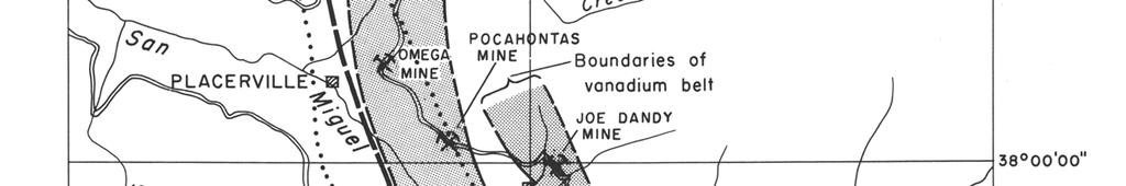
3 100 VANADIUM DEPOSITS OF THE PLACERVILLE AREA, SAN MIGUEL COUNTY, COLORADO' By R. P. FISCHER U.S. Geological Survey, Denver, Colo. INTRODUCTION The vanadium deposits of the Placerville area were discovered about Production totals about 240,000 tons of ore, which averaged a little more than 2 percent V205, and which probably yielded about 4,000 short tons of V20 5 in concentrates, representing a little less than 5 percent of the total domestic production of vanadium. Most of this ore was mined between 1910 and 1920, but some of it was produced during World War II and some since that war. Most of the ore contains, in addition to vanadium, 1 to 2 pounds of U30 8 per ton, and some of this has been recovered as a byproduct of the ore mined since about The vanadium deposits and general geology of the Placerville area were described by Hess (1911) and by Fischer and others (1947), and the geology of three quadrangles covering most of the area has been studied in detail by Bush and others (1959, 1960, and 1961 ). GEOLOGY Most of the Placerville area is underlain by nearly horizontal sedimentary beds of Permian to Cretaceous age, which have been intruded by Tertiary igneous rocks and cut by numerous faults. The vanadium deposits occur in the Entrada Sandstone of Late Jurassic age. The Cutler Formation of Permian age is the oldest formation exposed in the Placerville area. About 1,000 feet of Cutler beds crop out along the lower slopes of the San Miguel River valley and tributaries near Placerville. The formation is composed dominantly of lenticular beds of arkosic sandstone and conglomerate and a small proportion of thin siltstone and limestone beds. Most of these beds are purplish red. The Dolores Formation of Late Triassic age is separated from the Cutler by a disconformity of small relief. The Dolores consists of irregularly interbedded sandstone and siltstone, some conglomerate composed mainly of limestone pebbles, and a little mudstone and limestone. Brick red is the dominant color. The formation is nearly 600 feet thick. The Entrada Sandstone of Late Jurassic age is 40 to 75 feet thick in the area. It is composed entirely of light-colored sandstone, which is uniformly fine grained except for a small proportion of coarse, well-rounded sand grains in the lower part of the formation. From a distance the outcrop of the Entrada suggests that it is a single thick stratum, but actually the upper 5 to 20 feet of the formation 1. Publication authorized by the Director, U.S. Geological Survey. is rather thinly and evenly bedded and tends to form a ledgy cliff whereas the lower part is massively crossbedded and forms a steep slope or rounded cliff. The Entrada lies on a disconformity of small relief, and in places its contact with the underlying Dolores Formation is sharp, but elsewhere it is inconspicuous due to reworked material. The Wanakah Formation, also of Late Jurassic age, lies on the Entrada with a plane contact. It is composed of three members, of which the Pony Express Limestone Member is the lowest. This limestone is thin bedded, dark gray, fine grained, with a petroliferous odor from freshly broken surfaces. It is 10 to 15 feet thick several miles east of Placerville, but it thins to a depositional edge along a line that trends slightly west of north and crosses the San Miguel River valley at Placerville. The Pony Express is overlain by the Bilk Creek Sandstone Member, which averages about 30 feet thick and is composed of light-colored, fine-grained sandstone, similar to but slightly softer than the Entrada. The upper member of the Wanakah Formation is called the marl member and is composed of gray or red limy siltstone and a few thin beds of sandstone and silty limestone; the marl member averages about 50 feet thick in the Placerville area. The Morrison Formation is also of Late Jurassic age and is conformable with the Wanakah Formation. The Morrison is about 700 feet thick and is divided into two units of about equal thickness. The lower unit, the Salt Wash Sandstone Member, consists of reddish mudstone and light-brownish sandstone, mainly interbedded in layers several tens of feet thick, whereas the upper unit, the Brushy Basin Shale Member, consists dominantly of varicolored mudstone with some thin sandstone beds and a few lenses of conglomeratic sandstone. Beds of Cretaceous age in the Placerville area comprise three formations, the Burro Canyon Formation, the Dakota Sandstone, and the Mancos Shale in ascending order. The Burro Canyon consists of conglomeratic sandstone that occurs in thick channel-fill lenses, but these lenses are present in only a few places in the area. The Dakota Sandstone, on the other hand, was originally continuous over the area and caps the slopes of all the valleys in the area. The Dakota consists of beds of sandstone, in part conglomeratic, and shale. The Mancos is composed of darkgray shale and sparse thin beds of limestone, and it occurs only as poorly exposed erosional remnants on the mesa tops in the area. Several igneous dikes are conspicuous along the valley of the San Miguel River near Placerville and sills, laccoliths, and plugs are present nearby. These igneous rocks are varied in type, but they are dominantly intermediate
4
5
6 NEW MEXICO GEOLOGICAL SOCIETY NINETEENTH FIELD CONFERENCE 103 in composition. They are probably related to the intrusive rocks in the San Juan Mountains and are of middle to late Tertiary age. The sedimentary rocks in the Placerville area are nearly flat, but they are tilted by minor flexures and broken by numerous faults. All the faults are normal and dip steeply; displacements range from a few feet to as much as 700 feet. Most faults trend northward or northwestward. The faults and the igneous dikes are probably contemporaneous. VANADIUM DEPOSITS The vanadium deposits in the Placerville area occur in the upper part of the Entrada Sandstone and consist of sandstone impregnated with vanadium minerals. Roscoelite, the vanadium mica, is the principal ore mineral. It occurs as minute flakes that coat the sand grains and partly or completely fill the pore spaces between grains. Minor amounts of montroseite, a hydrous vanadium oxide, occur in high-grade ore. These minerals impart a greenish-gray color to the sandstone, and the color darkens as the vanadium content increases. Carnotite, the yellow hydrous uranium vanadate, is the only secondary mineral common in the deposits, and it occurs only sparsely at and near the surface where the ore is oxidized; no primary uranium mineral has been recognized. The vanadium deposits in the area occur as a continuously mineralized layer in two apparently separate belts. One belt is about 11/2 miles wide and extends for at least 9 miles from the point where the Entrada outcrop crosses Leopard Creek southward to where the Entrada crosses Big Bear Creek (fig. A). It is not known how much farther this belt might extend to the north and south of these points, for the Entrada is not exposed for many miles in these directions. The second belt is exposed for only about 11/2 miles along the Entrada outcrop north and east of Sawpit (fig. A), and therefore, its limits are not well known. In both belts the vanadium-bearing layer generally lies nearly parallel to the even bedding in the upper part of the Entrada Sandstone, but in detail the layer is wavy or undulant and crosses the bedding, ranging stratigraphically from the top of the Entrada to as much as 25 feet below the top. In most places the layer is only 3 to 6 inches thick, but it is clearly recognized by its greenish-gray color, although it is too thin and low grade to be mined. Locally, however, this layer thickens rather abruptly, forming lenticular or tabular masses that are minable. Individual ore bodies have a wide range in size. The small ones are only several feet across and a couple of feet thick and contain only a few tons of ore, whereas the large ones are a few hundred feet across and 2 to 20 feet thick and contain many thousand tons of ore. Ore bodies are diverse in plan but dominantly are roughly circular or irregularly elliptic. The long axes of the elongate bodies tend to be about perpendicular to the long axis of the principal belt. The ore bodies seem to be irregularly scattered within this belt, and no geologic relations that seem to control the localization of these bodies have been recognized. Figure B shows the ore bodies that were found at the outcrop and by drifting in the Fall Creek mine; it is assumed that if these drifts had been driven along other lines they would have found other ore bodies and probably just about as much ore. A thin, ill-defined layer of light-green sandstone, colored by a finely disseminated chromium-bearing mineral, lies a few feet below the vanadium-bearing layer in the Leopard Creek-Big Bear Creek belt and extends about a mile west of it (fig. A), forming a belt similar to the vanadium belt. Like the principal vanadium-ore mineral, the chromiumbearing mineral is micaceous and occupies the sandstone pores. This layer has no commercial value, for its average content is only a few hundredths percent Cr20 3, but it is a useful horizon marker. Like the vanadium-uranium and uranium deposits in sandstone in other parts of the Colorado Plateau region, the origin of the vanadium deposits in the Placerville area is unknown. The ore minerals obviously were emplaced after the Entrada Sandstone was deposited, for the vanadium-bearing layer crosses the sandstone bedding. On the other hand, this layer is displaced by faults, and almost certainly it formed before regional deformation. In some respects the pattern of the layer resembles a slightly uneven water table, or the contact between two ground waters of different composition, so possibly mineralization occurred under ground-water conditions. In the Placerville area the western depositional edge of the Pony Express Limestone Member, which lies on the Entrada, coincides closely with the western edge of the Leopard Creek-Big Bear Creek belt (fig. A); possibly the geochemical environment along the edge of this limestone during its deposition or sometime afterward influenced the localization of the vanadium and associated metals. LITERATURE CITED Bush, A. L. Bromfield, C. S., Marsh, 0. T., and Taylor, R. B., 1961, Preliminary geologic map of the Gray Head quadrangle, San Miguel County, Colorado: U.S. Geol. Survey Mineral Inv. Map MF-176. Bush, A. L., Bromfield, C. S., and Pierson, C. T., 1959, Areal geology of the Placerville quadrangle, San Miguel County, Colorado: U.S. Geol. Survey Bull E, p Bush, A. L., Marsh, 0. T., and Taylor, R. B., 1960, Areal geology of the Little Cone quadrangle, Colorado: U.S. Geol. Survey Bull G, p Fischer, R. P., Haff, J. C., and Rominger, J. R., 1947, Vanadium deposits near Placerville, San Miguel County, Colorado: Colorado Sci. Soc. Proc., v. 15, no. 3, p Hess, F. L., 1911, Notes on the vanadium deposits near Placerville, Colorado: U. S. Geol. Survey Bull. 530, p
New Mexico Geological Society
 New Mexico Geological Society Downloaded from: http://nmgs.nmt.edu/publications/guidebooks/43 Volcanic geology of the Rio Puerco necks R. Bruce Hallett, 1992, pp. 135-144 in: San Juan Basin IV, Lucas,
New Mexico Geological Society
 New Mexico Geological Society Downloaded from: http://nmgs.nmt.edu/publications/guidebooks/26 Direct-current soundings on the La Mesa surface near Kilbourne and Hunts Holes, New Mexico Dallas B. Jackson
New Mexico Geological Society
 New Mexico Geological Society Downloaded from: http://nmgs.nmt.edu/publications/guidebooks/9 Summary of coal resources of the Black Mesa coal field, Arizona R. B. O'Sullivan, 1958, pp. 169-171 in: Black
New Mexico Geological Society
 New Mexico Geological Society Downloaded from: http://nmgs.nmt.edu/publications/guidebooks/19 Multiple intrusions in the San Miguel Mountains, Colorado Calvin S. Bromfield and Alfred L. Bush, 1968, pp.
New Mexico Geological Society
 New Mexico Geological Society Downloaded from: http://nmgs.nmt.edu/publications/guidebooks/26 Tectonic significance of the Pony Hills, Luna County, New Mexico LeRoy L. Corbitt and Fred L. Nials, 1975,
New Mexico Geological Society
 New Mexico Geological Society Downloaded from: http://nmgs.nmt.edu/publications/guidebooks/29 Laramide thrust faulting, Klondike Hills, southwestern New Mexico LeRoy L. Corbitt, F. L. Nials, and R. J.
=%REPORT RECONNAISSANCE OF CHISHOLM LAKE PROSPECT. October 25, 1977
 =%REPORT ON FIELD RECONNAISSANCE OF CHISHOLM LAKE PROSPECT October 25, 1977 Bruce D. Vincent Imperial Oil Limited, Minerals - Coal, CALGARY, ALBERTA CHISHOLM LAKE PROSPECT Introduction The Chisholm Lake
New Mexico Geological Society
 New Mexico Geological Society Downloaded from: http://nmgs.nmt.edu/publications/guidebooks/25 Structure of the Guadalupe Box area, Sandoval County, New Mexico Harvey R. DuChene, 1974, pp. 131-135 in: Ghost
Structural Geology Lab. The Objectives are to gain experience
 Geology 2 Structural Geology Lab The Objectives are to gain experience 1. Drawing cross sections from information given on geologic maps. 2. Recognizing folds and naming their parts on stereoscopic air
1. How many unconformities exist in each column? Note that it is not the same number, necessarily, for each column!
 Geology 103 Name(s): Lab 5: Sequence stratigraphy Introduction: In the previous lab, you were able to illustrate Walther s Law by showing how transgressive rock sequences mirrored the offshore facies sequence.
New Mexico Geological Society
 New Mexico Geological Society Downloaded from: http://nmgs.nmt.edu/publications/guidebooks/32 Rio Blanco Oil Shale Company Tract C-a, Rio Blanco County, Colorado: Summary of geology and current development
Nortec Minerals announces Option to acquire 100% interest in the Cottonwood Vanadium-Uranium Project, Utah
 Nortec Minerals announces Option to acquire 100% interest in the Cottonwood Vanadium-Uranium Project, Utah Vancouver, BC / The Newswire / March 8, 2019 (the Company or Nortec ) (TSXV: NVT): Nortec announces
Page 1. Name:
 Name: Questions 1 through 3 refer to the following: The diagrams below represent two rock outcrops found several miles apart in New York State. Individual rock layers are lettered, and fossils and rock
New Mexico Geological Society
 New Mexico Geological Society Downloaded from: http://nmgs.nmt.edu/publications/guidebooks/25 Outline of the igneous geology of the Jemez Mountain volcanic field A. M. Kudo, 1974, pp. 287-289 in: Ghost
New Mexico Geological Society
 New Mexico Geological Society Downloaded from: http://nmgs.nmt.edu/publications/guidebooks/28 Influences of structure on Jurassic depositional patterns and uranium occurrences, northwestern New Mexico
ENGLE COAL FIELD. David E. Tabet
 OPEN FILE REPORT 115 SUMMARY OF THE GEOLOGY OF THE ENGLE COAL FIELD by David E. Tabet THE ENGLE COAL FIELD Introduction The Engle coal field (Lee, 1905), named for the small town of Engle along the Santa
New Mexico Geological Society
 New Mexico Geological Society Downloaded from: http://nmgs.nmt.edu/publications/guidebooks/13 Paleontological reconnaissance of subsurface Pennsylvanian in southern pache and Navajo Counties, rizona Donald
New Mexico Geological Society
 New Mexico Geological Society Downloaded from: http://nmgs.nmt.edu/publications/guidebooks/28 Geohydrology of the Westwater Canyon Member, Morrison Formation, of the southern San Juan Basin, New Mexico
SECTION 4 TABLES. 1 Summary of Hydrogeologic Parameters for Various Stratigraphic Units FIGURES
 SECTION 4 4.0 OVERVIEW OF GEOLOGY AND HYDROGEOLOGY... 13 4.1 Comparison of East and West Sides of Study Area... 15 4.2 Bedrock Sequence... 17 4.3 Mancos Shale (Upper Cretaceous)... 18 4.4 Mesaverde Formation
New Mexico Geological Society
 New Mexico Geological Society Downloaded from: http://nmgs.nmt.edu/publications/guidebooks/32 Geology of the Lisbon Valley Uranium district, southeastern Utah Gary C. Huber, 1981, pp. 177-182 in: Western
New Mexico Geological Society
 New Mexico Geological Society Downloaded from: http://nmgs.nmt.edu/publications/guidebooks/34 Recent measurements of crustal deformation related to the Socorro magma body, New Mexico Shawn Larsen and Robert
New Mexico Geological Society
 New Mexico Geological Society Downloaded from: http://nmgs.nmt.edu/publications/guidebooks/35 Structural anomalies in the Espanola Basin Bruce A. Black, 1984, pp. 59-62 in: Rio Grande Rift (Northern New
New Mexico Geological Society
 New Mexico Geological Society Downloaded from: http://nmgs.nmt.edu/publications/guidebooks/19 Pennsylvanian correlations in southwestern Colorado Sherman A. Wengerd and Ernest Szabo, 1968, pp. 159-164
Cretaceous, Dakota Formation, Terra Cotta Member South Side of I-70, Salina County, Kansas
 Cretaceous, Dakota Formation, Terra Cotta Member South Side of I-70, Salina County, Kansas Written By: Steven D.J. Baumann G-102010-1A Outcrop looking southeast Photo taken by: Steven Baumann on 10-20-2010
KRIS wsbssm. IBHiiilll
 KRIS wsbssm IBHiiilll Digitized by the Internet Archive in 2012 with funding from University of Illinois Urbana-Champaign http://archive.org/details/engineeringaspec34ekbl STATE OF ILLINOIS HENRY HORNER,
GEOLOGY OF THE NICOLA GROUP BETWEEN MISSEZULA LAKE AND ALLISON LAKE
 GEOLOGY OF THE NICOLA GROUP BETWEEN MISSEZULA LAKE AND ALLISON LAKE (92H/15E. 10E1 By V. A. Preto INTRODUCTION Mapping was continued southward from the area covered in 1973 and an additional 55 square
New Mexico Geological Society
 New Mexico Geological Society Downloaded from: http://nmgs.nmt.edu/publications/guidebooks/18 Ground water in the Window Rock-Lukachukai areas, Navajo Indian Reservation, Arizona and New Mexico Robert
New Mexico Geological Society
 New Mexico Geological Society Downloaded from: http://nmgs.nmt.edu/publications/guidebooks/27 Structural framework of the southern Raton Basin, New Mexico Lee A. Woodward and D. O. Snyder, 1976, pp. 125-127
New Mexico Geological Society
 New Mexico Geological Society Downloaded from: http://nmgs.nmt.edu/publications/guidebooks/30 Structure and stratigraphy of the Hagan embayment--a new look Bruce A. Black, 1979, pp. 101-105 in: Santa Fe
New Mexico Geological Society
 New Mexico Geological Society Downloaded from: http://nmgs.nmt.edu/publications/guidebooks/18 Geomorphology and structure in the Grants mineral belt Robert A. Laverty, 1967, pp. 188-194 in: Defiance, Zuni,
New Mexico Geological Society
 New Mexico Geological Society Downloaded from: http://nmgs.nmt.edu/publications/guidebooks/30 Geochronologic and rare-earth study of the Embudo granite and related rocks Marcia E. Register and D. G. Brookins,
New Mexico Geological Society
 New Mexico Geological Society Downloaded from: http://nmgs.nmt.edu/publications/guidebooks/16 The Cameron Creek laccolith: a trap-door intrustion near Silver City, New Mexico Walden P. Pratt and William
New Mexico Geological Society
 New Mexico Geological Society Downloaded from: http://nmgs.nmt.edu/publications/guidebooks/23 Structural interpretation of the fractures associated with the Bonita Fault D. W. Stearns, 1972, pp. 161-164
Structural Geology Lab. The Objectives are to gain experience
 Geology 2 Structural Geology Lab The Objectives are to gain experience 1. Drawing cross sections from information given on geologic maps. 2. Recognizing folds and naming their parts on stereoscopic air
ENVI.2030L Geologic Time
 Name ENVI.2030L Geologic Time I. Introduction There are two types of geologic time, relative and absolute. In the case of relative time geologic events are arranged in their order of occurrence. No attempt
Outcrops from Every Continent and 20 Countries in 140 Contributions. Tor H. Nilsen, Roger D. Shew, Gary S. Steffens, and Joseph R.J. Studlick.
 Paper VIII Tor H. Nilsen, Roger D. Shew, Gary S. Steffens, and Joseph R.J. Studlick Editors Outcrops from Every Continent and 20 Countries in 140 Contributions http://bookstore.aapg.org Length ~ 23 m (75.5
Robert S. Sawin Stratigraphic Research Section Kansas Geological Survey. Open-File Report
 Copies of Archived Correspondence Pertinent to the Decision to Classify the Exposure at Point of Rocks, Morton County, Kansas, as Jurassic by the Kansas Geological Survey in 1967 Robert S. Sawin Stratigraphic
GEOLOGY OF COLORADO NATIONAL MONUMENT
 GEOLOGY OF COLORADO NATIONAL MONUMENT Annabelle Foos, Geology Department, University of Akron Introduction 1 Colorado National Monument is a land of towering red sandstone monoliths and deep sheer-walled
THE STRUCTURE AND THICKNESS OF THE CLINTON AND BEREA FORMATIONS IN THE VICINITY OF WOOSTER, OHIO
 THE STRUCTURE AND THICKNESS OF THE CLINTON AND BEREA FORMATIONS IN THE VICINITY OF WOOSTER, OHIO KARL VER STEEG College of Wooster INTRODUCTION AND ACKNOWLEDGMENTS The data used in the construction of
SOUTH CERRO AZUL STRATIGRAPHIC SECTION. Upper Cerro Azul flow of the Servilleta Basalt (Tsbcau) Lower Sandlin unit (Tsl)
 Lower Sandlin unit (Tsl)") Figure A3-01 cobbles claysilt general grain size sand pebbles vf f m c vc SOUTH CERRO AZUL STRATIGRAPHIC SECTION Top at 18 m. Upper Cerro Azul flow of the Servilleta Basalt (Tsbcau) 15 Basalt: Very dark
Figure A3-01 cobbles claysilt general grain size sand pebbles vf f m c vc SOUTH CERRO AZUL STRATIGRAPHIC SECTION Top at 18 m. Upper Cerro Azul flow of the Servilleta Basalt (Tsbcau) 15 Basalt: Very dark
LITHOLOGIC FACIES OF A PORTION OF THE STILLWATER FORMATION DON B. GOULD
 118 PROCEEDINGS OF THE OKLAHOMA a LITHOLOGIC FACIES OF A PORTION OF THE STILLWATER FORMATION DON B. GOULD University of Iowa, Iowa City, Iowa The Permian rocks of the world are noted for their unusual
Geology 252, Historical Geology, California State University, Los Angeles - professor: Dr. Alessandro Grippo
 LAB # 1 - CLASTIC ROCKS Background: - Mechanical and Chemical Weathering - Production of Clastic Sediment - Classification of Sediment according to size: Gravel, Sand, Silt, Clay - Erosion, Transportation
1 Hfli. ^^Hi. 11 mw\i. mmsisi i lull I. IMMRrtHttiifHmiititlK. RibWh. llml ''.' 1 ffililsiillsll8 ill. iiiinitsim IK«
 l i. :,, v. i :! 1.» r =,
REPORT OF GEOLOGICAL MAPPING ON THE MICHEL COAL LICENSE #5177. LOCATION: KOOTENAY LAND DISTRICT NTS 82-G-7 4Y028 Lat f Long.
 i *. REPORT OF GEOLOGICAL MAPPING ON THE MICHEL COAL LICENSE #5177 LOCATION: KOOTENAY LAND DISTRICT NTS 82-G-7 4Y028 Lat. 114 40f Long. ESSO RESOURCES CANADA LIMITED WARD E. KILBY WORK: OCTOBER 17 - OCTOBER
Data Repository item
 Data Repository (B25407): Localities and descriptions of measured sections of study areas Table 1. Localities of the measured sedimentary sections in the NW Sichuan Basin Section Number Stratigraphy Locality
 27 Figure 7 Poorly cleaved, massive, light-weathering Bomoseen graywacke outcrop located on Brandon Mountain Road. Figure 8 Photomicrograph of Bomoseen graywacke. Subangular, poorly sorted quartz grains
PRECAMBRIAN CRYSTALLINE AQUIFER (METAMORPHIC ROCKS)
") HAYWARD QUADRANGLE: Groundwater Production by Aquifer In the 56-square-mile area of the Hayward Quadrangle, groundwater is produced from metamorphic crystalline rocks of the Precambrian basement (in the
HAYWARD QUADRANGLE: Groundwater Production by Aquifer In the 56-square-mile area of the Hayward Quadrangle, groundwater is produced from metamorphic crystalline rocks of the Precambrian basement (in the
Section 5. Rock Units and Your Community. What Do You See? Think About It. Investigate. Learning Outcomes
 Chapter 3 Minerals, Rocks, and Structures Section 5 Rock Units and Your Community What Do You See? Learning Outcomes In this section, you will Recognize that rocks are arranged in Earth s crust as well-defined
454/01 GEOLOGY GL4 EXTENSION GEOLOGY. P.M. FRIDAY, 14 June (2 Hours)
") WELSH JOINT EDUCATION COMMITTEE General Certificate of Education Advanced CYD-BWYLLGOR ADDYSG CYMRU Tystysgrif Addysg Gyffredinol Uwch 454/01 GEOLOGY GL4 EXTENSION GEOLOGY P.M. FRIDAY, 14 June 2002 (2
WELSH JOINT EDUCATION COMMITTEE General Certificate of Education Advanced CYD-BWYLLGOR ADDYSG CYMRU Tystysgrif Addysg Gyffredinol Uwch 454/01 GEOLOGY GL4 EXTENSION GEOLOGY P.M. FRIDAY, 14 June 2002 (2
EPS 50 Lab 6: Maps Topography, geologic structures and relative age determinations
 Name: EPS 50 Lab 6: Maps Topography, geologic structures and relative age determinations Introduction: Maps are some of the most interesting and informative printed documents available. We are familiar
New Mexico Geological Society
 New Mexico Geological Society Downloaded from: http://nmgs.nmt.edu/publications/guidebooks/9 The Shinarump Member of the Chinle Formation Charles G. Evensen, 1958, pp. 95-97 in: Black Mesa Basin (Northeastern
a) Piedmont: e) Monument: f) Plateau: g) Mesa: h) Butte: i) Playa: j) Perennial Stream:
 Piedmont: e) Monument: f) Plateau: g) Mesa: h) Butte: i) Playa: j) Perennial Stream:") Name: Lab day: Tuesday Wednesday CEEES/SC 10110L-20110L Planet Earth Laboratory Laboratory #11: Arid Environments & Landforms Readings: See handout at http://www.nd.edu/~cneal/physicalgeo/lab-deserts/index.html.
Name: Lab day: Tuesday Wednesday CEEES/SC 10110L-20110L Planet Earth Laboratory Laboratory #11: Arid Environments & Landforms Readings: See handout at http://www.nd.edu/~cneal/physicalgeo/lab-deserts/index.html.
Geological History of the Grand Canyon
 Geological History of the Grand Canyon For a copy of this assignment, print a copy of this web page. The Project Your job is to write a short paper that describes the geological history of the Grand Canyon
Some Geological Features at Smalls Falls, Maine
 Maine Geologic Facts and Localities July, 2005 Some Geological Features at Smalls Falls, Maine 44 51 30.47 N, 70 30 58.74 W Text by Robert Marvinney, Department of Agriculture, Conservation & Forestry
LINGUAU DEPOSITION IN THE WOODBINE SANDS ALONG COPPERAS BRANCH, DENTON COUNTY. TEXAS: A STUDY IN MARINE SEDIMENTATION
 LINGUAU DEPOSITION IN THE WOODBINE SANDS ALONG COPPERAS BRANCH, DENTON COUNTY. TEXAS: A STUDY IN MARINE SEDIMENTATION Ellis W. Shuler and Olin M. Millican The lack of outcrops in three dimensions often
/ h / -) S D /O I. <$il - imptecjiyid-rej) hs>c/c. J. Wallace Gwynn Assisted By -Bilt-Oalness. MINERS unuivrin TTTinnnnur n nir innr OCCURRENCES
 S D /O I. <$il - imptecjiyid-rej) hs>c/c. J. Wallace Gwynn Assisted By -Bilt-Oalness. MINERS unuivrin TTTinnnnur n nir innr OCCURRENCES") / h / -) S D /O I f CAPITOL REEF c/c MINERS unuivrin TTTinnnnur n nir innr OCCURRENCES By J. Wallace Gwynn Assisted By -Bilt-Oalness 1967 CAPITOL REEF-MINERS MOUNTAIN BITUMINOUS
/ h / -) S D /O I f CAPITOL REEF c/c MINERS unuivrin TTTinnnnur n nir innr OCCURRENCES By J. Wallace Gwynn Assisted By -Bilt-Oalness 1967 CAPITOL REEF-MINERS MOUNTAIN BITUMINOUS
NEW MEXICO INSTITUTE OF MINING 8c TECHNOLOGY E J Workman, President STATE BUREAU OF MINES Sc MINERAL RESOURCES Eugene Callaghan, Director THE REGENTS
 BULLETIN 31 Geology of the Thoreau Quadrangle, McKinley and Valencia Counties, New Mexico BY CLAY T. SMITH Structure, stratigraphy, and mineral and groundwater resources of a part of the northeast flank
Geology 12 FINAL EXAM PREP. Possible Written Response Exam Questions
 Geology 12 FINAL EXAM PREP Possible Written Response Exam Questions Use this study guide to prepare for the written response portion of the final exam. Name FINAL EXAM - POSSIBLE WRITTEN RESPONSE QUESTIONS
P.R. SPRING AND HILL CREEK TAR SAND AREAS A RESOURCE ASSESSMENT (IN PROGRESS)
") P.R. SPRING AND HILL CREEK TAR SAND AREAS A RESOURCE ASSESSMENT (IN PROGRESS) presented by WALLY GWYNN - Utah Geological Survey at the Western U.S. Oil Sands Technology Transfer Meeting February 22, 2008
P.R. SPRING AND HILL CREEK TAR SAND AREAS A RESOURCE ASSESSMENT (IN PROGRESS) presented by WALLY GWYNN - Utah Geological Survey at the Western U.S. Oil Sands Technology Transfer Meeting February 22, 2008
BUREAU OF MINERAL RESOURCES GEOLOGY AND GEOPHYSICS
 COMMONWEALTH OF AUSTRALIA DEPARTMENT OF NATIONAL DEVELOPMENT BUREAU OF MINERAL RESOURCES GEOLOGY AND GEOPHYSICS RECORDS: 1 9 67/77 PHOTO-INTERPRETATION OF BURKETOWN 1:250,000 SCALE SHEET QUEENSLAND. by
Stratigraphy and structure of the Ganson Hill area: northern Taconic Allochthon
 University at Albany, State University of New York Scholars Archive Geology Theses and Dissertations Atmospheric and Environmental Sciences 1985 Stratigraphy and structure of the Ganson Hill area: northern
Soils, Hydrogeology, and Aquifer Properties. Philip B. Bedient 2006 Rice University
 Soils, Hydrogeology, and Aquifer Properties Philip B. Bedient 2006 Rice University Charbeneau, 2000. Basin Hydrologic Cycle Global Water Supply Distribution 3% of earth s water is fresh - 97% oceans 1%
GEOLOGIC MAPS PART II
 EARTH AND ENVIRONMENT THROUGH TIME LABORATORY - EES 1005 LABORATORY FIVE GEOLOGIC MAPS PART II Introduction Geologic maps of orogenic belts are much more complex than maps of the stable interior. Just
MEMO. TO: Dennis Lapoint CC: FROM: Eriaan Wirosono DATE: April, 20 th 2014 SUBJECT: Exploration activity report March-April 2014_EW
 TO: Dennis Lapoint CC: FROM: Eriaan Wirosono DATE: April, 20 th 2014 SUBJECT: Exploration activity report March-April 2014_EW MEMO 1. Highlights and Productivity Overview pan sampling on target Areas 1
Name. GEOL.5220 Structural Geology Faults, Folds, Outcrop Patterns and Geologic Maps. I. Properties of Earth Materials
 I. Properties of Earth Materials GEOL.5220 Structural Geology Faults, Folds, Outcrop Patterns and Geologic Maps Name When rocks are subjected to differential stress the resulting build-up in strain can
THE TOPOGRAPHY AND GEOLOGY OF THE GRAND PORTAGE^
 THE TOPOGRAPHY AND GEOLOGY OF THE GRAND PORTAGE^ Few areas within the boundaries of Minnesota are of greater historical interest than the region surrounding the Grand Portage, which long before the first
GLY 155 Introduction to Physical Geology, W. Altermann. Press & Siever, compressive forces. Compressive forces cause folding and faulting.
 Press & Siever, 1995 compressive forces Compressive forces cause folding and faulting. faults 1 Uplift is followed by erosion, which creates new horizontal surface. lava flows Volcanic eruptions cover
New Mexico Geological Society
 New Mexico Geological Society Downloaded from: http://nmgs.nmt.edu/publications/guidebooks/27 Tonstein occurrences in the Raton coal field, Colfax County, New Mexico Bruce F. Bohor and C. L. Pillmore,
Geologic Map of the Hatch Quadrangle, Doña County, New Mexico
 Geologic Map of the Hatch Quadrangle, Doña County, New Mexico By William R. Seager May 1995 New Mexico Bureau of Geology and Mineral Resources Open-file Digital Geologic Map OF-GM 213 Scale 1:24,000 This
Structural Geology of the Mountains
 Structural Geology of the Mountains Clinton R. Tippett Shell Canada Limited, Calgary, Alberta clinton.tippett@shell.ca INTRODUCTION The Southern Rocky Mountains of Canada (Figure 1) are made up of several
3. GEOLOGY. 3.1 Introduction. 3.2 Results and Discussion Regional Geology Surficial Geology Mine Study Area
 3. GEOLOGY 3.1 Introduction This chapter discusses the baseline study of the geology and mineralization characteristics of the mine study area. The study consolidates existing geological data and exploration
Dakota Sandstone. of the Moxa Arch and Surrounding Green River Basin
 Dakota Sandstone of the Moxa Arch and Surrounding Green River Basin Dakota Sandstones of the Green River Basin Overview The Dakota sandstones of the Moxa Arch and surrounding Green River Basin remain attractive
Continental Landscapes
 Continental Landscapes Landscape influenced by tectonics, climate & differential weathering Most landforms developed within the last 2 million years System moves toward an equilibrium Continental Landscapes
N. J. Macala. C ONTENT S. LIST OF PLATES.
 REPORT ON WATER SUikLY AT MANBULLOO STATION, NORTHERN TERRITORY. by N. J. Macala. Records 1957/62. C ONTENT S. Page. Introduction. 1. General Geology, 1. Hydrology. 1. New Bore Sites Selected. 2. Reference.
Data Repository item DATA REPOSITORY
 Data Repository item 2003053 1 DATA REPOSITORY Stable isotope and trace-element geochemistry of the basal Bouse Formation carbonate, southwestern USA: Implications for the Pliocene uplift history of the
ENGINEER S CERTIFICATION OF FAULT AREA DEMONSTRATION (40 CFR )
") PLATTE RIVER POWER AUTHORITY RAWHIDE ENERGY STATION BOTTOM ASH TRANSFER (BAT) IMPOUNDMENTS LARIMER COUNTY, CO ENGINEER S CERTIFICATION OF FAULT AREA DEMONSTRATION (40 CFR 257.62) FOR COAL COMBUSTION RESIDUALS
PLATTE RIVER POWER AUTHORITY RAWHIDE ENERGY STATION BOTTOM ASH TRANSFER (BAT) IMPOUNDMENTS LARIMER COUNTY, CO ENGINEER S CERTIFICATION OF FAULT AREA DEMONSTRATION (40 CFR 257.62) FOR COAL COMBUSTION RESIDUALS
Excerpts from RockTalk V o l. 9, No. 2
 Excerpts from RockTalk V o l. 9, No. 2 Pure elemental uranium is a slightly radioactive metal, silvery white in color and dense (almost as dense as gold). Elemental uranium metal does not occur in nature
!'f \, w. Alan Stewart Colorado Exploration Company, Golden STRUCTURE OF THE FOOTHILLS AREA WEST OF DENVER, COLORADO. Introduction
 STRUCTURE OF THE FOOTHLLS AREA WEST OF DENVER, COLORADO w. Alan Stewart Colorado Exploration Company, Golden ntroduction i ; The dominant structural features west of Denver and along the mountain front
 UNIT DESCRIPTIONS: Artificial Fill, Undocumented (Afu): Locally derived sandy silt and silty sand, locally with clay and varying amounts of gravel and man-made debris. Abundant concrete rubble, in places
New Mexico Geological Society
 New Mexico Geological Society Downloaded from: http://nmgs.nmt.edu/publications/guidebooks/1 Jurassic formations of parts of Utah, Colorado and New Mexico William B. Hoover, 1950, pp. 76-81 in: San Juan
City of Fort Collins: Geology Staff Training, June 2012
 1 City of Fort Collins: Geology Staff Training, June 2012 Levels of Analysis Descriptive (What do you see, feel, hear, etc..) This rock is made of round grains of quartz. Interpretive-- (The detective
In this lab, we will study and analyze geologic maps from a few regions, including the Grand Canyon, western Wyoming, and coastal California.
 Name: Lab Section: work in groups, but each person turns in his/her own GEOSCIENCE 001 LAB UNDERSTANDING GEOLOGIC MAPS Geologic maps are colorful and even beautiful, but they also contain an amazing amount
URANIUM RESOURCES IN NEW MEXICO. Virginia T. McLemore New Mexico Bureau of Geology and Mineral Resources, New Mexico Tech, Socorro, NM
 URANIUM RESOURCES IN NEW MEXICO Virginia T. McLemore New Mexico Bureau of Geology and Mineral Resources, New Mexico Tech, Socorro, NM Purpose Describe the uranium industry in New Mexico, with emphasis
FIELD GUIDE TO THE GEOLOGY ALONG THE OLD KILN TRAIL Boulder, Colorado City of Boulder Open Space and Mountain Parks
 FIELD GUIDE TO THE GEOLOGY ALONG THE OLD KILN TRAIL Boulder, Colorado City of Boulder Open Space and Mountain Parks Sue E. Hirschfeld, Ph.D. On the Old Kiln Trail you will be walking through geologic time
Rock Identification Lab, 60 Points This is a BIG lab! Work carefully and thoroughly
 Rock Identification Lab, 60 Points This is a BIG lab! Work carefully and thoroughly Name: Date: Period: Lab Skills and Objectives 1. You will examine, classify, and identify several samples of igneous,
New Mexico Geological Society
 New Mexico Geological Society Downloaded from: http://nmgs.nmt.edu/publications/guidebooks/34 Magma bodies in the Rio Grande rift in central New Mexico Allan R. Sanford, 1983, pp. 123-125 in: Socorro Region
SIEVING FOR CLAST SIZE Teacher s Guide
 SIEVING FOR CLAST SIZE Teacher s Guide ABSTRACT: Students take samples from two different geological layers and sieve for clast size mass data. They will also make sketches of some of the clasts and describe
General Geology Lab #7: Geologic Time & Relative Dating
 General Geology 89.101 Name: General Geology Lab #7: Geologic Time & Relative Dating Purpose: To use relative dating techniques to interpret geological cross sections. Procedure: Today we will be interpreting
BUREAU OF MINERAL RESOURCES GEOLOGY AND GEOPHYSICS.
 Copy for Chief Geophysioira COMMONWEALTH OF AUSTRALIA. DEPARTMENT OF NATIONAL DEVELOPMENT. BUREAU OF MINERAL RESOURCES GEOLOGY AND GEOPHYSICS. RECORDS. 196 2/25 REPORT ON KUMBRUF GOLD PROSPECT MADANGDISTRICT,
SL GEOLOGY AND MINING. Coal bearing strata in the project area are referable primarily to the Allegheny Group of
 SL-145-1 GEOLOGY AND MINING Coal bearing strata in the project area are referable primarily to the Allegheny Group of Pennsylvania age. These rocks occur as dissected remnants overlying the ridge-forming
UNDERSTANDING GEOLOGIC M APS
 Name: Lab Section: work in groups, but each person turns in his/her own GEOSCIENCE 001 L AB UNDERSTANDING GEOLOGIC M APS Geologic maps are colorful and even beautiful, but they also contain an amazing
Black Point & Bihler Point
 Black Point & Bihler Point Conglomerate Photo: looking north toward end of Black Point (south of post 1) All of the rocks in this photo are conglomerate. Both Black Point and Bihler Point are formed from
GEOL 02: Historical Geology Lab 14: Topographic Maps. Name: Date:
 GEOL 02: Historical Geology Lab 14: Topographic Maps Name: Date: A topographic map is a two dimensional (flat) representation (model) of a three dimensional land surface (landscape). It shows landforms
New Mexico Geological Society
 New Mexico Geological Society Downloaded from: http://nmgs.nmt.edu/publications/guidebooks/16 Some aspects of the Kneeling Nun rhyolite tuff David L. Giles, 1965, pp. 164-166 in: Southwestern New Mexico
UmllluIfiW, SfOLOGICAL SURVEY
 UmllluIfiW, SfOLOGICAL SURVEY 3 3051 00005 8770 Digitized by the Internet Archive in 2012 with funding from University of Illinois Urbana-Champaign http://archive.org/details/heavymineralsini01shro s
SUPPLEMENTAL MATERIAL
 SUPPLEMENTAL MATERIAL DESCRIPTIONS OF OTHER STRATIGRAPHIC SECTIONS Cherry Creek In its middle reaches, Cherry Creek meanders between three paired terraces within a narrow bedrock valley. The highest is
GEOLOGY OF TODMORDEN MOOR 2 BACKGROUND
 GEOLOGY OF TODMORDEN MOOR 2 BACKGROUND 1) THE CARBONIFEROUS SERIES OF ROCKS The rocks of the Todmorden district are of the Carboniferous Series and were first laid down in an ancient sea, which covered
Deep Time: How Old Is Old?
 Deep Time: How Old Is Old? Updated by: Rick Oches, Professor of Geology & Environmental Sciences Bentley University Waltham, Massachusetts Based on slides prepared by: Ronald L. Parker, Senior Geologist
Learning Target: I can create a foldable about the geologic principles that are used to relatively date rock sequences.
 Geologic Principles Learning Target: I can create a foldable about the geologic principles that are used to relatively date rock sequences. 1 Geologic Principles Foldable You will need 3 pieces of paper
Chapter 2. Regional Landscapes and the Hydrologic Cycle
 Chapter 2. Regional Landscapes and the Hydrologic Cycle W. Lee Daniels Department of Crop and Soil Environmental Sciences, Virginia Tech Table of Contents Introduction... 23 Soils and landscapes of the