New Mexico Geological Society
|
|
|
- Felix Hancock
- 6 years ago
- Views:
Transcription
, Shomaker, J. W.; [ed.], New Mexico Geological Society 19 th Annual Fall Field Conference Guidebook, 212 p.")
1 New Mexico Geological Society Downloaded from: Pennsylvanian correlations in southwestern Colorado Sherman A. Wengerd and Ernest Szabo, 1968, pp in: San Juan, San Miguel, La Plata Region (New Mexico and Colorado), Shomaker, J. W.; [ed.], New Mexico Geological Society 19 th Annual Fall Field Conference Guidebook, 212 p. This is one of many related papers that were included in the 1968 NMGS Fall Field Conference Guidebook. Annual NMGS Fall Field Conference Guidebooks Every fall since 1950, the New Mexico Geological Society (NMGS) has held an annual Fall Field Conference that explores some region of New Mexico (or surrounding states). Always well attended, these conferences provide a guidebook to participants. Besides detailed road logs, the guidebooks contain many well written, edited, and peer-reviewed geoscience papers. These books have set the national standard for geologic guidebooks and are an essential geologic reference for anyone working in or around New Mexico. Free Downloads NMGS has decided to make peer-reviewed papers from our Fall Field Conference guidebooks available for free download. Non-members will have access to guidebook papers two years after publication. Members have access to all papers. This is in keeping with our mission of promoting interest, research, and cooperation regarding geology in New Mexico. However, guidebook sales represent a significant proportion of our operating budget. Therefore, only research papers are available for download. Road logs, mini-papers, maps, stratigraphic charts, and other selected content are available only in the printed guidebooks. Copyright Information Publications of the New Mexico Geological Society, printed and electronic, are protected by the copyright laws of the United States. No material from the NMGS website, or printed and electronic publications, may be reprinted or redistributed without NMGS permission. Contact us for permission to reprint portions of any of our publications. One printed copy of any materials from the NMGS website or our print and electronic publications may be made for individual use without our permission. Teachers and students may make unlimited copies for educational use. Any other use of these materials requires explicit permission.
2 This page is intentionally left blank to maintain order of facing pages.
3 PENNSYLVANIAN CORRELATIONS IN SOUTHWESTERN COLORADO By SHERMAN A. WENGERD University of New Mexico, Albuquerque, New Mexico 159 ERNEST SZABO Denver, Colorado, and Albuquerque, New Mexico INTRODUCTION Private research by the authors, both independently and in collaboration, has resulted in a practical subdivision of the Pennsylvanian stratal section of the entire region of the Paradox basin and its surrounding shelves. The sediment increments of Early to early Middle Pennsylvanian age are known to be bounded by widely correlative time markers regardless of the lithology of the sediment increment. Recognition of these markers requires the availability of gamma ray-neutron or sonic logs; however, they can be recognized on excellent electric logs and sample logs in many wells. PURPOSE The purpose of this short paper is to extend our wellestablished correlations from nearby wells in the Paradox basin to the outcrop section to be examined during the field trip in the Animas Canyon north of Durango, Colorado. This section has been studied by many geologists and an historical review of the published studies was presented by Wengerd (1957). It has been suggested by the American Stratigraphic Commission (1961) that no new names be given stratal units in regional and local society guidebooks, and we have suggested no new names; all are in articles already published. What we have done is tighten up the correlation network by shifting the names about a bit. This short paper is thus only a preview of a formal article which may be published later in the Bulletin of the American Association of Petroleum Geologists. SEDIMENTATIONAL SUBDIVISION The Lower Pennsylvanian section of the Paradox region consists of an heterogenous sequence of rock types whose detailed study on gamma ray-neutron and sample logs shows that the sequence can be subdivided into sendimentational units which have vertical individuality and great lateral persistence. Although the log character of each unit is relatively constant, it may appear expanded or compressed, reflecting changes in thickness. These sediment increments, bounded by correlative time markers, can be recognized over a wide area, greatly facilitating log correlations. CYCLE CORRELATION The saline facies of the Lower Pennsylvanian consists of a sequence of cycles as described by Herman and Barkell (1957, p. 867) and later correlated by Hite (1960). Regional correlation of gamma ray-neutron logs shows the presence of 29 cycles near the middle of the basin, and suggests the possibility that five other cycles may be developed immediately above the Molas Formation in the area north of the Continental, Scorup No. 1 (T. 47 N., R. 18 W., Sec. 8, Colorado ). Stratigraphic nomenclature has not been a serious problem in this area of the basin, due in part to the ease with which salt cycles can be correlated, and in part to lack of interest in the economic potential of the area. STRATIGRAPHIC NOMENCLATURE The stratigraphic nomenclature of the shelf area of the Paradox basin was acceptably simplified by a nomenclature committee of the Four Corners Geological Society ( Malin, 1958), and subsequent additions within the framework created by this committee have meshed well. Certain discrepancies in unit boundaries between the base of the Barker Creek and the top of the Molas Formation can be resolved very easily. These discrepancies are the result of projecting correlations from the area of salt deposition to the sequence along the shelf margin. These correlations show the need for adjusting formation boundaries to coincide with major breaks in cyclic deposition. Beyond these minor adjustments, any complaint of stratigraphic nomenclatural complexity resolves itself into an academic debate between the proponents of time-stratigraphic nomenclature and those favoring the rock-stratigraphic approach. A dual system is both awkward and unnecessary, and the problem may be resolved rather easily by regional correlations of wells which penetrated the Lower Pennsylvanian sequence. SEDIMENTARY UNITS The cycles of the basin center area are members of certain gross units bounded by time markers which can be projected into the sequence of the shelf margin. These markers coincide with the boundaries of certain zones proposed by Malin (1958) and other workers. Any of the stratal sequences, between thin marker units, produces a distinctive log character which can be identified and mapped throughout much of the Paradox region. It has been proposed ( Szabo, 1968, p. 15) that the Paradox Formation, as used by Wengerd (1962, p. 280) be elevated to group status and that the stratigraphic units currently called "pay
4

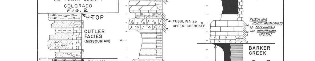
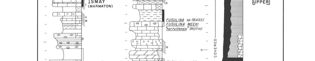
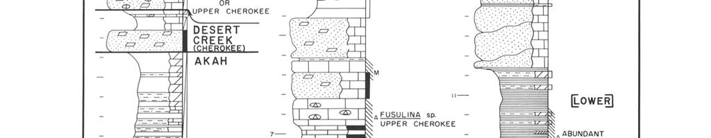
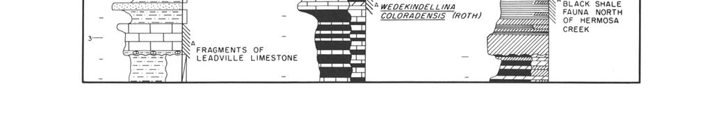
5 NEW MEXICO GEOLOGICAL SOCIETY-NINETEENTH FIELD CONFERENCE 161 zones" or zones be raised to formation rank. This change is in agreement with Articles 6 and 9 in the Code of Stratigraphic Nomenclature (American Commission on Stratigraphic Nomenclature, 1961, p ) and since the proposed units are mappable formations whose boundaries coincide with the boundaries of time-stratigraphic units, the stage-substage nomenclature of Baars and others (1967, p. 401) appears to represent unnecessary terminology. A more utilitarian nomenclature is presented in Table 1. LIME RIDGE PROBLEM The greatest single change recommended here is the substitution of the name Lime Ridge for strata of Atokan age. This time slice had been discussed as pre-desmoinesian by Clair (1952, p. 37) and was later designated as the Lime Ridge Formation (Clair, 1958, p. 34 ). This required restriction of the Pinkerton Trail Formation to the basal part of the Desmoinesian. Other stratigraphers have included Atokan strata of quite different lithologic characteristics in the Pinkerton Trail (Clair, 1958, Wengerd and Matheny, 1958, Wengerd, 1962, Baars and others 1967), but Clair (1952 and 1958 ) recognized an important unconformity below which are found pre-desmoinesian strata of greater-than-usually-recognized economic potential. These pre-desmoinesian strata include the Pinkerton Trail Formation as first defined by Wengerd and Strickland (1954, p ). Well-exposed sections at Pinkerton Creek Trail across the Encantado cliffs, and along the road to Rico across the Hermosa cliffs at Columbine, plus time-marker controlled correlation in Paradox wells suggest that the name "Pinkerton Trail" should be applied to cycles 25 through 29 of earliest Desmoinesian age, as recommended in this paper. For the following reasons, we suggest that Pinkerton Trail of the original type locality be called Lime Ridge, which includes the Molas facies, and that Pinkerton Trail Formation be moved up into the basal Desmoinesian, as a valid mappable formation below the Alkali Gulch: 1. Clair (1952) set the stage by calling these beds pre- Desmoinesian. 2. Wengerd and Strickland (1954) found both Atokan and Desmoinesian fossils in pre-paradox strata at the Hermosa Mountain locality. 3. This change agrees with Baars and others (1967) that Fusulinella is Atokan. 4. Agreement is offered with Clair who established a type locality for pre-desmoinesian strata in the subsurface of Lime Ridge anticline on the Monument upwarp in Utah (1952) and named these strata the Lime Ridge (1958). 5. We see the validity of this adjustment to eliminate confusion in the stratigraphic nomenclature of the Paradox shelf areas. MOLAS FACIES The Molas facies is a "residual soil" zone recognized in the Paradox region both north and south of the Uncompahgre upleft. In outcrops, it is recognized as far southeastward as Cedro Canyon, east of Albuquerque, New Mexico. Regional correlation of the Molas reveals that a marine shale unit laterally equivalent to the Molas is present in the subsurface near Price, Utah (Szabo, 1968, p. 23), in a part of the section originally referred to as th Manning Canyon Formation (Sadlick, 1956, p. 74). This marine section is probably equivalent, in part, to the Belden Formation of Morrowan age in northwestern Colorado and northeastern Utah. MAPPABLE FORMATIONS Use of the proposed stratigraphic nomenclature in the Paradox region permits the mapping of units of formational rank bounded by time-stratigraphic surfaces. The nomenclature is also compatible with fusulinid zonations proposed by Baars and others (1967, p. 402) if Lime Ridge is substituted for Pinkerton Trail in the Fusulinella zone. Correlation of selected logs in southwestern Colorado, using the proposed nomenclature, is presented in Figure 1. The Reynolds, Point Lookout No. 1, T. 36N., R. 14 W., Sec. 18, Montezuma County, Colorado, is considered to be an ideal (but not necessarily typical) log for the study of these proposed formation tops in this area. HERMOSA MOUNTAIN SECTION The position of subsurface formation intercepts has been projected to the surface section measured at the Hermosa Mountain locality by Wengerd and Strickland (1954, p ). The projected position of these tops is shown in Figure 2 in this paper. Between 1957 and 1958, correlation of the Animas Canyon section of Pennsylvanian strata evolved in response to more finite subdivision of equivalent beds in the subsurface as more wells were drilled, and as more names were added to define the stratal section (Wengerd, 1957, Wengerd and Matheny, 1958, Wengerd, 1962). Figure 2 shows the latest specific correlations with names applied which have been published previously. The time-markers utilized are adequately controlled by fusulinid determinations from the

6
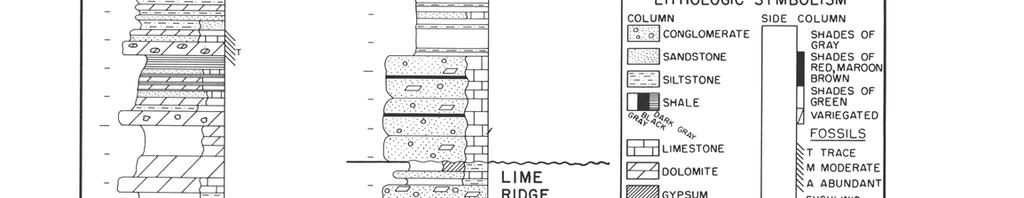
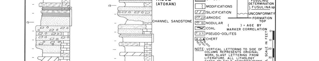
7
8 164 NEW MEXICO GEOLOGICAL SOCIETY NINETEENTH FIELD CONFERENCE Hermosa Mountain section itself and from numerous wells in the Paradox basin. Several striking conditions are mentioned below, without detailed explanation. 1. The lower Cutler red-beds are doubtless of Pennsylvanian age, a suggestion made by Roth, Thompson, Bass, and Wengerd in earlier publications not referenced here. 2. The Ismay is higher in the section than anyone had dared to suggest previously; clearly a function of closeness to source of terrestrial elastics from the emerging Uncompahgre uplife. 3. Most of the Ismay elastics are non-arkosic quartzose sandstones. 4. Coarse elastics of the Desert Creek through Lime Ridge Formations are predominantly arkosic granulites, believed to be from the San Luis highland to the northeast, rather than from the later Uncompahgre to the north and northwest. 5. The Desert Creek section is very thin, presaging either a slow initial rise of sea bottom to decrease sedimentational space as the Uncompahgre began to lift, or pre-ismay erosion of a previously deposited, thicker Desert Creek. 6. If all the coarse elastics are arbitrarily deleted from the section, the stratal section is somewhat similar to that in some parts of the southwestern sedimentational slope of the Paradox basin. 7. Sandstone and granulite channels in the Lime Ridge Formation show the positive tendency of the mobile border of the San Luis uplift just prior to the ponderous subsidence of Paradox evaporite basin, wherein the predominant evaporite deposits are of Pinkerton Trail, Alkali Gulch, Barker Creek, Akah, and Desert Creek age. 8. There can be little doubt that the coarse elastics of the Paradox group are distal, high, steep-shelf equivalents of thick salt lentils; these elastic sediment incursions took place cyclically as this eastern mobile border pulsed upward, simultaneous with basinal subsidence, while salt was being deposited in the Paradox basin. REFERENCES American Commission on Stratigraphic Nomenclature, 1961, Code of stratigraphic nomenclature Am. Assoc. Petroleum Geologists Bull., v. 45, p Baars, D. L., Parker, J. W., and Chronic, J., 1967, Revised stratigraphic nomenclature of Pennsylvanian System, Paradox basin: Am. Assoc. Petroleum Geologists Bull., v. 51, no. 3, p Clair, J. R., 1952, Paleozoic rocks of the southern Paradox basin; in Geological Symposium of the Four Corners region, Four Corners Geol. Soc., Clair, J. R., 1958, Stratigraphy of the Pennsylvanian of the Paradox basin; in Symposium on Pennsylvanian rocks of Colorado and adjacent areas, Rocky Mountain Assoc. Geologists, p Herman, G., and Barkell, C. A., 1957, Pennsylvanian stratigraphy and production zones, Paradox salt basin : Am. Assoc. Petroleum Geologists, Bull., v.41, No. 5, p Hite, R. J., 1960, Stratigraphy of the saline facies of the Paradox member of the Hermosa Formation; in Geology of the Paradox basin fold and fault belt, Four Corners Geol. Soc. Guidebook, 3rd Field Conf. p Malin, W. J., 1958, A preliminary informal system of nomenclature for a part of the Pennsylvanian of the Paradox basin; in Geology of the Paradox basin, Intermountain Assoc. Petroleum Geologists Guidebook, 9th Ann. Field Conf., p Sadlick, W., Some Upper Devonian Mississippian problems in eastern Utah; in Geology and economic deposits of east central Utah, Intermountain Assoc. Petroleum Geologists Guidebook, 7th Field Conf. p Szabo, E., 1968, Pennsylvanian paleotectonics of the Paradox region in parts of Utah, Arizona, New Mexico, and Colorado: unpublished doctoral dissertation, University of New Mexico, 137 p. Wengerd, S. A., and Strickland, J. W., 1954, Pennsylvanian Stratigraphy of Paradox salt basin. Four Corners region, Colorado and Utah: Am. Assoc. Petroleum Geologists Bull., v. 38, no. 10, p Wengerd, S. A., 1957, Permo-Pennsylvanian strata of the western San Juan Mountains, Colorado; in Guidebook of Southwestern San Juan Mountains, New Mexico Geol. Soc., 8th Field Conf., p Wengerd, S. A., and Matheny, M. L., 1958, Pennsylvanian system of Four Corners region Am. Assoc. Petroleum Geologists Bull., v. 42, no. 9, p Wengerd, S. A., 1962, Pennsylvanian sedimentation in Paradox basin Four Corners region; in Pennsylvanian System in the United States, Am. Assoc. Petroleum Geologists, p
New Mexico Geological Society
 New Mexico Geological Society Downloaded from: http://nmgs.nmt.edu/publications/guidebooks/43 Volcanic geology of the Rio Puerco necks R. Bruce Hallett, 1992, pp. 135-144 in: San Juan Basin IV, Lucas,
New Mexico Geological Society
 New Mexico Geological Society Downloaded from: http://nmgs.nmt.edu/publications/guidebooks/26 Direct-current soundings on the La Mesa surface near Kilbourne and Hunts Holes, New Mexico Dallas B. Jackson
New Mexico Geological Society
 New Mexico Geological Society Downloaded from: http://nmgs.nmt.edu/publications/guidebooks/29 Laramide thrust faulting, Klondike Hills, southwestern New Mexico LeRoy L. Corbitt, F. L. Nials, and R. J.
New Mexico Geological Society
 New Mexico Geological Society Downloaded from: http://nmgs.nmt.edu/publications/guidebooks/13 Paleontological reconnaissance of subsurface Pennsylvanian in southern pache and Navajo Counties, rizona Donald
New Mexico Geological Society
 New Mexico Geological Society Downloaded from: http://nmgs.nmt.edu/publications/guidebooks/9 Pennsylvanian paleogeography of Arizona Kay Havenor and Willard D. Pyr, 1958, pp. 78-81 in: Black Mesa Basin
New Mexico Geological Society
 New Mexico Geological Society Downloaded from: http://nmgs.nmt.edu/publications/guidebooks/35 Structural anomalies in the Espanola Basin Bruce A. Black, 1984, pp. 59-62 in: Rio Grande Rift (Northern New
New Mexico Geological Society
 New Mexico Geological Society Downloaded from: http://nmgs.nmt.edu/publications/guidebooks/25 Structure of the Guadalupe Box area, Sandoval County, New Mexico Harvey R. DuChene, 1974, pp. 131-135 in: Ghost
New Mexico Geological Society
 New Mexico Geological Society Downloaded from: http://nmgs.nmt.edu/publications/guidebooks/26 Tectonic significance of the Pony Hills, Luna County, New Mexico LeRoy L. Corbitt and Fred L. Nials, 1975,
New Mexico Geological Society
 New Mexico Geological Society Downloaded from: http://nmgs.nmt.edu/publications/guidebooks/32 Rio Blanco Oil Shale Company Tract C-a, Rio Blanco County, Colorado: Summary of geology and current development
New Mexico Geological Society
 New Mexico Geological Society Downloaded from: http://nmgs.nmt.edu/publications/guidebooks/28 Pre-carboniferous paleotectonics of the San Juan Basin, New Mexico G. M. Stevenson and D. L. Baars, 1977, pp.
New Mexico Geological Society
 New Mexico Geological Society Downloaded from: http://nmgs.nmt.edu/publications/guidebooks/34 Recent measurements of crustal deformation related to the Socorro magma body, New Mexico Shawn Larsen and Robert
New Mexico Geological Society
 New Mexico Geological Society Downloaded from: http://nmgs.nmt.edu/publications/guidebooks/33 Paleozoic history of the Albuquerque trough--implications for basement control on the Rio Grande rift Donald
New Mexico Geological Society
 New Mexico Geological Society Downloaded from: http://nmgs.nmt.edu/publications/guidebooks/27 Structural framework of the southern Raton Basin, New Mexico Lee A. Woodward and D. O. Snyder, 1976, pp. 125-127
Structural Geology Lab. The Objectives are to gain experience
 Geology 2 Structural Geology Lab The Objectives are to gain experience 1. Drawing cross sections from information given on geologic maps. 2. Recognizing folds and naming their parts on stereoscopic air
New Mexico Geological Society
 New Mexico Geological Society Downloaded from: http://nmgs.nmt.edu/publications/guidebooks/28 Geohydrology of the Westwater Canyon Member, Morrison Formation, of the southern San Juan Basin, New Mexico
New Mexico Geological Society
 New Mexico Geological Society Downloaded from: http://nmgs.nmt.edu/publications/guidebooks/9 Summary of coal resources of the Black Mesa coal field, Arizona R. B. O'Sullivan, 1958, pp. 169-171 in: Black
Case Study of the Structural and Depositional-Evolution Interpretation from Seismic Data*
 Case Study of the Structural and Depositional-Evolution Interpretation from Seismic Data* Yun Ling 1, Xiangyu Guo 1, Jixiang Lin 1, and Desheng Sun 1 Search and Discovery Article #20143 (2012) Posted April
New Mexico Geological Society
 New Mexico Geological Society Downloaded from: http://nmgs.nmt.edu/publications/guidebooks/19 Vanadium deposits of the Placerville area, San Miguel County, Colorado R. P. Fischer, 1968, pp. 100-103 in:
Dakota Sandstone. of the Moxa Arch and Surrounding Green River Basin
 Dakota Sandstone of the Moxa Arch and Surrounding Green River Basin Dakota Sandstones of the Green River Basin Overview The Dakota sandstones of the Moxa Arch and surrounding Green River Basin remain attractive
New Mexico Geological Society
 New Mexico Geological Society Downloaded from: http://nmgs.nmt.edu/publications/guidebooks/27 Subsurface Paleozoic stratigraphy of the northeastern New Mexico basin and arch complex J. Wayland Roberts,
New Mexico Geological Society
 New Mexico Geological Society Downloaded from: http://nmgs.nmt.edu/publications/guidebooks/30 Structure and stratigraphy of the Hagan embayment--a new look Bruce A. Black, 1979, pp. 101-105 in: Santa Fe
New Mexico Geological Society
 New Mexico Geological Society Downloaded from: http://nmgs.nmt.edu/publications/guidebooks/19 Character of part of the Hermosa Formation (Pennsylvanian), San Juan Mountains, Colorado W. Arch Girdley, 1968,
New Mexico Geological Society
 New Mexico Geological Society Downloaded from: http://nmgs.nmt.edu/publications/guidebooks/25 Outline of the igneous geology of the Jemez Mountain volcanic field A. M. Kudo, 1974, pp. 287-289 in: Ghost
Lower Skinner Valley Fill Sandstones: Attractive Exploration Targets on the Northeast Oklahoma Platform*
 Lower Skinner Valley Fill Sandstones: Attractive Exploration Targets on the Northeast Oklahoma Platform* By Jim Puckette 1 Search and Discovery Article #10050 (2003) *Adapted from presentation to Tulsa
IP 121 ILLINOIS PETROLEUJM Illinois Institute of Natdral Resources STATE GEOWGICA SURVEY DIVISION' Jack A. Simon. Chief
 IP 121 ILLINOIS PETROLEUJM 121 1981 Illinois Institute of Natdral Resources STATE GEOWGICA SURVEY DIVISION' Jack A. Simon. Chief Stevenson, D. L. (David L.) Geologic structure of the base of the New Albany
New Mexico Geological Society
 New Mexico Geological Society Downloaded from: http://nmgs.nmt.edu/publications/guidebooks/32 Summary of Paleozoic stratigraphy and history of western Colorado and eastern Utah John A. Campbell, 1981,
New Mexico Geological Society
 New Mexico Geological Society Downloaded from: http://nmgs.nmt.edu/publications/guidebooks/23 Structural interpretation of the fractures associated with the Bonita Fault D. W. Stearns, 1972, pp. 161-164
Cretaceous Shelf Sandstones and Shelf Depositional Sequences, Western Interior Basin, Utah, Colorado and New Mexico
 Cretaceous Shelf Sandstones and Shelf Depositional Sequences, Western Interior Basin, Utah, Colorado and New Mexico Salt Lake City, Utah to Albuquerque, New Mexico June 30-July 7, 1989 Field Trip Guidebook
Outcrop to subsurface stratigraphy of the Pennsylvanian Hermosa Group southern Paradox Basin U.S.A.
 Louisiana State University LSU Digital Commons LSU Doctoral Dissertations Graduate School 2002 Outcrop to subsurface stratigraphy of the Pennsylvanian Hermosa Group southern Paradox Basin U.S.A. Alan Lee
New Mexico Geological Society
 New Mexico Geological Society Downloaded from: http://nmgs.nmt.edu/publications/guidebooks/32 Potential petroleum resources of northeastern Utah and northwestern Colorado Albert F. Sanborn, 1981, pp. 255-266
New Mexico Geological Society
 New Mexico Geological Society Downloaded from: http://nmgs.nmt.edu/publications/guidebooks/30 Geochronologic and rare-earth study of the Embudo granite and related rocks Marcia E. Register and D. G. Brookins,
New Mexico Geological Society
 New Mexico Geological Society Downloaded from: http://nmgs.nmt.edu/publications/guidebooks/18 Geomorphology and structure in the Grants mineral belt Robert A. Laverty, 1967, pp. 188-194 in: Defiance, Zuni,
Sequence Stratigraphy. Historical Perspective
 Sequence Stratigraphy Historical Perspective Sequence Stratigraphy Sequence Stratigraphy is the subdivision of sedimentary basin fills into genetic packages bounded by unconformities and their correlative
New Mexico Geological Society
 New Mexico Geological Society Downloaded from: http://nmgs.nmt.edu/publications/guidebooks/32 Geology of the Lisbon Valley Uranium district, southeastern Utah Gary C. Huber, 1981, pp. 177-182 in: Western
Plate tectonics model for the continental collisions during Late Paleozoic
 Alleghanian orogeny During Late Paleozoic, northwestern Africa collided with southeastern North America, causing the Alleghanian orogeny, and building the Appalachian mountains. The orogeny began during
New Mexico Geological Society
 New Mexico Geological Society Downloaded from: http://nmgs.nmt.edu/publications/guidebooks/26 Tertiary floras from the Rio Grande Rift Daniel I. Axelrod, 1975, pp. 85-88 in: Las Cruces Country, Seager,
1. How many unconformities exist in each column? Note that it is not the same number, necessarily, for each column!
 Geology 103 Name(s): Lab 5: Sequence stratigraphy Introduction: In the previous lab, you were able to illustrate Walther s Law by showing how transgressive rock sequences mirrored the offshore facies sequence.
STRATIGRAPHIC CORRELATION OF THE LATE PENNSYLVANIAN- EARLY PERMIAN STRATA IN THE DELAWARE BASIN
 STRATIGRAPHIC CORRELATION OF THE LATE PENNSYLVANIAN- EARLY PERMIAN STRATA IN THE DELAWARE BASIN An Undergraduate Research Scholars Thesis by KIKE KOMOLAFE and KAELA DEMMERLE Submitted to the Undergraduate
Structural Geology Lab. The Objectives are to gain experience
 Geology 2 Structural Geology Lab The Objectives are to gain experience 1. Drawing cross sections from information given on geologic maps. 2. Recognizing folds and naming their parts on stereoscopic air
Stratigraphy and Hydrocarbon Production from Pennsylvanian Age Granite Wash Reservoirs in the Western Anadarko Basin, Oklahoma and Texas
 Stratigraphy and Hydrocarbon Production from Pennsylvanian Age Granite Wash Reservoirs in the Western Anadarko Basin, Oklahoma and Texas John Mitchell, Managing Partner/Consulting Geologist Fall River
REPORT OF INVESTIGATION NO. 37 UTAH GEOLOGICAL AND MINERALOGICAL SURVEY
 REPORT OF INVESTIGATION NO. 37 UTAH GEOLOGICAL AND MINERALOGICAL SURVEY DETERMINATION OF OIL.SHALE POTENTIAL GREEN RIVER FORMATION, UINTA BASIN NORTHEAST UTAH Prepared by Howard R..Ritzma Petroleum Geologist
New Mexico Geological Society
 New Mexico Geological Society Downloaded from: http://nmgs.nmt.edu/publications/guidebooks/21 Thrust faults of Florida Mountains, New Mexico, and their regional tectonic significance LeRoy L. Corbitt and
GLY 155 Introduction to Physical Geology, W. Altermann. Press & Siever, compressive forces. Compressive forces cause folding and faulting.
 Press & Siever, 1995 compressive forces Compressive forces cause folding and faulting. faults 1 Uplift is followed by erosion, which creates new horizontal surface. lava flows Volcanic eruptions cover
Seismic stratigraphy, some examples from Indian Ocean, interpretation of reflection data in interactive mode
 Seismic stratigraphy, some examples from Indian Ocean, interpretation of reflection data in interactive mode K. S. Krishna National Institute of Oceanography, Dona Paula, Goa-403 004. krishna@nio.org Seismic
The Impact of Parasequence Stacking Patterns on Vertical Connectivity Between Wave-Dominated, Shallow Marine Parasequences, Book Cliffs, Eastern Utah
 The Impact of Parasequence Stacking Patterns on Vertical Connectivity Between Wave-Dominated, Shallow Marine Parasequences, Book Cliffs, Eastern Utah MALCOLM J. ARNOT and TIMOTHY R. GOOD* MALCOLM J. ARNOT
THE NEW HARMONY GROUP (LOWER DEVONIAN)
") 2001. Proceedings of the Indiana Academy of Science 1 10:23-27 THE NEW HARMONY GROUP (LOWER DEVONIAN) REVISITED 1 John B. Droste and Alan S. Horowitz Department of Geological Sciences, Indiana : University,
2001. Proceedings of the Indiana Academy of Science 1 10:23-27 THE NEW HARMONY GROUP (LOWER DEVONIAN) REVISITED 1 John B. Droste and Alan S. Horowitz Department of Geological Sciences, Indiana : University,
Deep Time: How Old Is Old?
 Deep Time: How Old Is Old? Updated by: Rick Oches, Professor of Geology & Environmental Sciences Bentley University Waltham, Massachusetts Based on slides prepared by: Ronald L. Parker, Senior Geologist
Overview of Selected Shale Plays in New Mexico*
 Overview of Selected Shale Plays in New Mexico* Ron Broadhead 1 Search and Discovery Article #10627 (2014)** Posted August 18, 2014 *Adapted from presentation at RMAG luncheon meeting, Denver, Colorado,
Sequence Biostratigraphy and Depositional Modelling of the Pennsylvanian-Permian Belloy Formation Peace River Embayment, Alberta Canada
 Page No. 104-1 Sequence Biostratigraphy and Depositional Modelling of the Pennsylvanian-Permian Belloy Formation Peace River Embayment, Alberta Canada Lindsay A. Dunn* and Charles M. Henderson Applied
New Mexico Geological Society
 New Mexico Geological Society Downloaded from: http://nmgs.nmt.edu/publications/guidebooks/29 Pennsylvanian and Early Permian depositional framework, southeastern Arizona Charles A. Ross, 1978, pp. 193-200
Depositional Sequences Sequences
 Depositional Sequences Transgressive and Regressive packages can be bound by unconformities Because sediment can only be preserved during net aggradation and progradation All other times there is either
Geothermal Gradients and Geothermal Opportunities in the Piceance Basin, Colorado
 Geothermal Gradients and Geothermal Opportunities in the Piceance Basin, Colorado Paul Morgan, Colorado Geological Survey, 1313 Sherman Street, Room 715, Denver, CO 80203: morgan@mines.edu 1. Abstract
New Mexico Geological Society
 New Mexico Geological Society Downloaded from: http://nmgs.nmt.edu/publications/guidebooks/34 Magma bodies in the Rio Grande rift in central New Mexico Allan R. Sanford, 1983, pp. 123-125 in: Socorro Region
When last we left off. Western Cordillera NA. Cretaceous. Cretaceous, continued. Cretaceous to present
 When last we left off Western Cordillera NA Cretaceous to present Wild and weird things happened in the murky past of the Archean and precambrian Cambrian through Devonian development of deep water sediments
Sequence Stratigraphic Analysis of Mixed, Reefal Carbonate and Siliciclastic Systems. Ashton Embry. Geological Survey of Canada.
 Sequence Stratigraphic Analysis of Mixed, Reefal Carbonate and Siliciclastic Systems Ashton Embry Geological Survey of Canada Outline Sequence Stratigraphy Sequence Surfaces and Sequence Boundaries for
GY 112L Earth History
 GY 112L Earth History Lab 2 Vertical Successions and Sequences of Events GY 112L Instructors: Douglas Haywick, James Connors, Mary Anne Connors Department of Earth Sciences, University of South Alabama
Structural Style in the Peel Region, NWT and Yukon
 Structural Style in the Peel Region, NWT and Yukon Adriana Taborda* Husky Energy and University of Calgary, Calgary, AB Adriana.Taborda@huskyenergy.ca and Deborah Spratt University of Calgary, Calgary,
Quarterly Report April 1 - June 30, By: Shirley P. Dutton. Work Performed Under Contract No.: DE-FC22-95BC14936
 DE-FC22-95BC14936--18 Application of Advanced Reservoir Characterization, Simulation, and Production Optimization Strategies to Maximize Recovery in Slope, and Basin Clastic Reservoirs, West Texas (Delaware
Basin & Range / Mojave Desert
 Basin & Range / Mojave Desert Basin & Range vs. Great Basin 1 2/20/2016 An overview of the last horst Basin and Range / Mojave Desert Summary: Granitic, volcanic, marine sedimentary, non marine sedimentary,
New Mexico Geological Society
 New Mexico Geological Society Downloaded from: http://nmgs.nmt.edu/publications/guidebooks/27 Depositional environments and trace fossils of the Trinidad Sandstone, southern Raton Basin, New Mexico Charles
Abstract. Introduction. Regional Setting. GCSSEPM to be published December 2003
 Shelf Margin Deltas and Associated Deepwater Deposits: Implications on Reservoir Distribution and Hydrocarbon Entrapment, Block VI-1, Ulleung Basin, East Sea, South Korea Sneider, John S. Sneider Exploration,
NOTICE CONCERNING COPYRIGHT RESTRICTIONS
 NOTICE CONCERNING COPYRIGHT RESTRICTIONS This document may contain copyrighted materials These materials have been made available for use in research, teaching, and private study, but may not be used for
SOUTHWESTERN SAN JUAN MOUNTAINS COLORADO EIGHTH FIELD CONFERENCE SEPTEMBER 5, 6 & 7, 1957
 NEW MEXICO GEOLOGICAL SOCIETY Guidebook I OF SOUTHWESTERN SAN JUAN MOUNTAINS COLORADO EIGHTH FIELD CONFERENCE SEPTEMBER 5, 6 & 7, 1957 N E W M E X I C O G E O L O G I C A L S O C I E T Y * E I G H T H
CHAPTER 2. GEOLOGIC SETTING Martin K. Dubois
 CHAPTER 2. GEOLOGIC SETTING Martin K. Dubois Regional Geology The Hugoton field lies on the west side of the Hugoton embayment of the Anadarko basin and is bounded to the northwest by the Las Animas arch
New Mexico Geological Society
 New Mexico Geological Society Downloaded from: http://nmgs.nmt.edu/publications/guidebooks/28 Influences of structure on Jurassic depositional patterns and uranium occurrences, northwestern New Mexico
The Hickory Sandstone, South-Central Texas
 The Hickory Sandstone, South-Central Texas Goals of the project The research question for the Hickory Sandstone project is just like that for the Jackfork Group project: how were the rocks of the Hickory
Structural Geology of the Mountains
 Structural Geology of the Mountains Clinton R. Tippett Shell Canada Limited, Calgary, Alberta clinton.tippett@shell.ca INTRODUCTION The Southern Rocky Mountains of Canada (Figure 1) are made up of several
New Mexico Geological Society
 New Mexico Geological Society Downloaded from: http://nmgs.nmt.edu/publications/guidebooks/24 Structural framework and tectonic evolution of the Four Corners region of the Colorado Plateau Lee A. Woodward,
The McCully gas field in southern New Brunswick was discovered in the year 2000 on a joint drilling exploration venture by Corridor Resources Inc.
 1 The McCully gas field in southern New Brunswick was discovered in the year 2000 on a joint drilling exploration venture by Corridor Resources Inc. and Potash Corporation of Saskatchewan. Located about
Bulletin of Earth Sciences of Thailand. Controls on Reservoir Geometry and Distribution, Tantawan Field, Gulf of Thailand.
 Controls on Reservoir Geometry and Distribution, Tantawan Field, Gulf of Thailand Atchara Praidee Petroleum Geoscience Program, Department of Geology, Faculty of Science, Chulalongkorn University, Bangkok
New Mexico Geological Society
 New Mexico Geological Society Downloaded from: http://nmgs.nmt.edu/publications/guidebooks/31 Seismicity in the Basin and Range province of Texas and northeastern Chihuahua, Mexico David B. Dumas, 1980,
Geology Stratigraphic Correlations (Lab #4, Winter 2010)
") Name: Answers Reg. lab day: Tu W Th Geology 1023 Stratigraphic Correlations (Lab #4, Winter 2010) Introduction Stratigraphic correlation is the process of comparing rocks at one locality with related rocks
Name: Answers Reg. lab day: Tu W Th Geology 1023 Stratigraphic Correlations (Lab #4, Winter 2010) Introduction Stratigraphic correlation is the process of comparing rocks at one locality with related rocks
EGAS. Ministry of Petroleum
 EGAS Ministry of Petroleum EGAS Ministry of Petroleum About The Block Location: N. El Arish offshore block is located in the extreme eastern part of the Egypt s economic water border and bounded from the
LAS ANIMAS ARCH PROVINCE (040)
") LAS ANIMAS ARCH PROVINCE (040) By C. William Keighin INTRODUCTION The Las Animas Arch of southeastern Colorado is a north-northeast striking structural high, bounded on the south by the Apishipa Uplift.
LAS ANIMAS ARCH PROVINCE (040) By C. William Keighin INTRODUCTION The Las Animas Arch of southeastern Colorado is a north-northeast striking structural high, bounded on the south by the Apishipa Uplift.
FY 2008 Annual Technical Report for NCRDS State Cooperative Program
 FY 2008 Annual Technical Report for NCRDS State Cooperative Program SUBSURFACE JURASSIC AND CRETACEOUS GAS-SHALE SAMPLES, HAYNESVILLE AND BOSSIER FORMATIONS (SABINE UPLIFT), AND EAGLEFORD GROUP (RIO GRANDE
The Green River and Wasatch formations in the Lake Uinta, and
 DCA ~280m Oil-stained Sandstone Consortium Proposal: Lacustrine Reservoirs from Deep to Shallow: Facies Distribution, Architecture, and Source Rock Formation Green River Formation, Utah & Colorado Microbial
BALOCHISTAN FOLDBELT BASIN
 INTRODUCTION BALOCHISTAN FOLDBELT BASIN The Kharan-3 block is located in the Kharan Trough of Balochistan Basin. GEOLOGICAL SETTING The Balochistan Province is an Upper Cretaceous to Recent structurally
Sequence Stratigraphy: An Applied Workshop
 Sequence Stratigraphy: An Applied Workshop Instructor: Prof. Octavian Catuneanu Level: Intermediate Duration: 5 days Course Description and Objectives This workshop presents the concepts and practical
Stephanie B. Gaswirth and Kristen R. Mara
 U.S. Geological Survey Assessment of Undiscovered Resources in the Bakken and Three Forks Formations, Williston Basin, North Dakota, Montana, and South Dakota, 2013 Stephanie B. Gaswirth and Kristen R.
New Mexico Geological Society
 New Mexico Geological Society Downloaded from: http://nmgs.nmt.edu/publications/guidebooks/19 Coal-bearing formations in the western part of the San Juan basin of New Mexico Edward C. Beaumont, 1968, pp.
Calcite Cements in Middle Devonian Dunedin Formation:
 Geochemistry of the Fracture-Filling Dolomite and Calcite Cements in Middle Devonian Dunedin Formation: Implication for the Strata Dolomitization Model Sze-Shan Yip 1, Hairuo Qing 1 and Osman Salad Hersi
Southern Songkhla Basin, Gulf of Thailand
 Architecture and Depositional Environment of Fluvial Systems of Southern Songkhla Basin, Gulf of Thailand Toan Manh Do Petroleum Geoscience Program, Department of Geology, Faculty of Science, Chulalongkorn
Lab 2 Geological Time and Fossil Samples
 Geol G308 Paleontology and Geology of Indiana Name: Lab 2 Geological Time and Fossil Samples This lab has two components: understanding geological time scales and choosing fossil samples from the IU Paleontology
GEOLOGY MEDIA SUITE Chapter 8
 UNDERSTANDING EARTH, SIXTH EDITION GROTZINGER JORDAN GEOLOGY MEDIA SUITE Chapter 8 Clocks in Rocks Timing the Geologic Record 2010 W.H. Freeman and Company Stratigraphy and fossils Figure 8.4 (page 172)
CENTRAL UTAH: A NEW OIL AND GAS PROVINCE
 CENTRAL UTAH: A NEW OIL AND GAS PROVINCE By Floyd and Mike By: Floyd Moulton and Mike Pinnell Wolverine Discovery Eastern Limit of Thrusting Presentation Outline Regional Setting Paleozoic Source Rock
Answers: Internal Processes and Structures (Isostasy)
") Answers: Internal Processes and Structures (Isostasy) 1. Analyse the adjustment of the crust to changes in loads associated with volcanism, mountain building, erosion, and glaciation by using the concept
Answers: Internal Processes and Structures (Isostasy) 1. Analyse the adjustment of the crust to changes in loads associated with volcanism, mountain building, erosion, and glaciation by using the concept
Bulletin of Earth Sciences of Thailand. Evaluation of the Petroleum Systems in the Lanta-Similan Area, Northern Pattani Basin, Gulf of Thailand
 Evaluation of the Petroleum Systems in the Lanta-Similan Area, Northern Pattani Basin, Gulf of Thailand Sirajum Munira Petroleum Geoscience Program, Department of Geology, Faculty of Science, Chulalongkorn
Outline 16: The Mesozoic World: Formation of Oil Deposits (with a side trip to the Devonian Marcellus Shale)
") Outline 16: The Mesozoic World: Formation of Oil Deposits (with a side trip to the Devonian Marcellus Shale) The first commercial oil well was drilled by Colonel Edwin Drake in Titusville, Pennsylvania,
Outline 16: The Mesozoic World: Formation of Oil Deposits (with a side trip to the Devonian Marcellus Shale) The first commercial oil well was drilled by Colonel Edwin Drake in Titusville, Pennsylvania,
Risk Factors in Reservoir Simulation
 Risk Factors in Reservoir Simulation Dr. Helmy Sayyouh Petroleum Engineering Cairo University 12/26/2017 1 Sources Of Data Petro-physical Data Water saturation may be estimated from log analysis, capillary
In this lab, we will study and analyze geologic maps from a few regions, including the Grand Canyon, western Wyoming, and coastal California.
 Name: Lab Section: work in groups, but each person turns in his/her own GEOSCIENCE 001 LAB UNDERSTANDING GEOLOGIC MAPS Geologic maps are colorful and even beautiful, but they also contain an amazing amount
OIL AND GAS POTENTIAL AND REASONABLE FORESEEABLE DEVELOPMENT (RFD) SCENARIOS IN THE SAN JUAN NATIONAL FOREST AND BLM PUBLIC LANDS, COLORADO
 SCENARIOS IN THE SAN JUAN NATIONAL FOREST AND BLM PUBLIC LANDS, COLORADO") OIL AND GAS POTENTIAL AND REASONABLE FORESEEABLE DEVELOPMENT (RFD) SCENARIOS IN THE SAN JUAN NATIONAL FOREST AND BLM PUBLIC LANDS, COLORADO Prepared By: Prepared By:. 36 West Main Street Cortez, Colorado
OIL AND GAS POTENTIAL AND REASONABLE FORESEEABLE DEVELOPMENT (RFD) SCENARIOS IN THE SAN JUAN NATIONAL FOREST AND BLM PUBLIC LANDS, COLORADO Prepared By: Prepared By:. 36 West Main Street Cortez, Colorado
Name. GEOL.5220 Structural Geology Faults, Folds, Outcrop Patterns and Geologic Maps. I. Properties of Earth Materials
 I. Properties of Earth Materials GEOL.5220 Structural Geology Faults, Folds, Outcrop Patterns and Geologic Maps Name When rocks are subjected to differential stress the resulting build-up in strain can
Issues Related to Oklahoma Coalbed- Methane Activity,
 Figure 1. Map of the eastern Oklahoma coalfield (modified from Friedman, 1974). Issues Related to Oklahoma Coalbed- Methane Activity, 1988 2008 Brian J. Cardott Oklahoma Geological Survey INTRODUCTION
4. Carboniferous Zone Play Results
 C H A P T E R F O U R 4. Carboniferous Zone Play Results 4. Geological Overview In the WCSB, there were two main depositional areas during Carboniferous time the Peace River Embayment in northwestern Alberta,
New Mexico Geological Society
 New Mexico Geological Society Downloaded from: http://nmgs.nmt.edu/publications/guidebooks/54 The Middle Jurassic Entrada Sandstone in northeastern Arizona and adjacent areas Robert B. O'Sullivan, 2003,
ENVI.2030L Geologic Time
 Name ENVI.2030L Geologic Time I. Introduction There are two types of geologic time, relative and absolute. In the case of relative time geologic events are arranged in their order of occurrence. No attempt
USGS: USGS: NEIC NEIC
 Triggered Earthquakes in North-Central Arkansas and their Relationship to Class II UIC Wells Scott M. Ausbrooks, The Arkansas Geological Survey Steve Horton, Ph.D., CERI at University i of Memphis Contributors:
Robert S. Sawin Stratigraphic Research Section Kansas Geological Survey. Open-File Report
 Copies of Archived Correspondence Pertinent to the Decision to Classify the Exposure at Point of Rocks, Morton County, Kansas, as Jurassic by the Kansas Geological Survey in 1967 Robert S. Sawin Stratigraphic
Follow this and additional works at: Part of the Geology Commons
 Western Michigan University ScholarWorks at WMU Michigan Geological Repository for Research and Education Geosciences 2016 Geology of Michigan William B. Harrison III Michigan Geological Repository for
Contractor Name and Address: Oxy USA, Inc. (Oxy), Midland, Texas OBJECTIVES
, Midland, Texas OBJECTIVES") 1 F TITLE: APPLICATION OF RESERVOIR CHARACTERIZATION AND ADVANCED TECHNOLOGY TO IMPROVE RECOVERY AND ECONOMICS IN A LOWER QUALITY SHALLOW SHELF CARBONATE RESERVOIR Cooperative Agreement No.: DE - FC22-948C14990
1 F TITLE: APPLICATION OF RESERVOIR CHARACTERIZATION AND ADVANCED TECHNOLOGY TO IMPROVE RECOVERY AND ECONOMICS IN A LOWER QUALITY SHALLOW SHELF CARBONATE RESERVOIR Cooperative Agreement No.: DE - FC22-948C14990