a) Piedmont: e) Monument: f) Plateau: g) Mesa: h) Butte: i) Playa: j) Perennial Stream:
|
|
|
- Meagan Carter
- 5 years ago
- Views:
Transcription
1 Name: Lab day: Tuesday Wednesday CEEES/SC 10110L-20110L Planet Earth Laboratory Laboratory #11: Arid Environments & Landforms Readings: See handout at This lab is out of 52 points. 1) What do the following terms mean/refer to? (10) a) Piedmont: b) Pediment: c) Bajada: d) Inselberg: e) Monument: f) Plateau: g) Mesa: h) Butte: i) Playa: j) Perennial Stream: 2) The map (on pages 3 & 4) represents a portion of Bennetts Well, California, 1:62,500 quadrangle. This is in the heart of Death Valley. The lowest elevation in the United States, 282 feet below sea level, occurs within this quadrangle. Because Death Valley is below sea level, all of the drainage in this area flows into the valley no streams flow out! The Amargosa River flows North when it flows at all. Rainfall averages about 5 centimeters or 2 inches per year, but it commonly comes in big storms after years of virtually no rain. Most erosion occurs during these storms. a) Most valleys form as erosion moves loose material and streams transport it out of the valley. But that cannot happen here. The valley was formed by faulting and the faults are still active. Movement on a near-vertical fault on one side of the valley caused that side of the valley to drop. On which side of the valley is this fault [Assume North is to the top of the page]? Cite at least two pieces of evidence to back your choice. (3) 1
2 b) What name is given to the landform between the valley and the mountain front on the west side of the map? (1) What is the gradient of this feature, in feet/mile, between BM -242 (negative 242) on the road and the 19 in Section 19 to the west (both highlighted by red arrows)? (4) 2

3 WEST SIDE 3

4 EAST SIDE 4
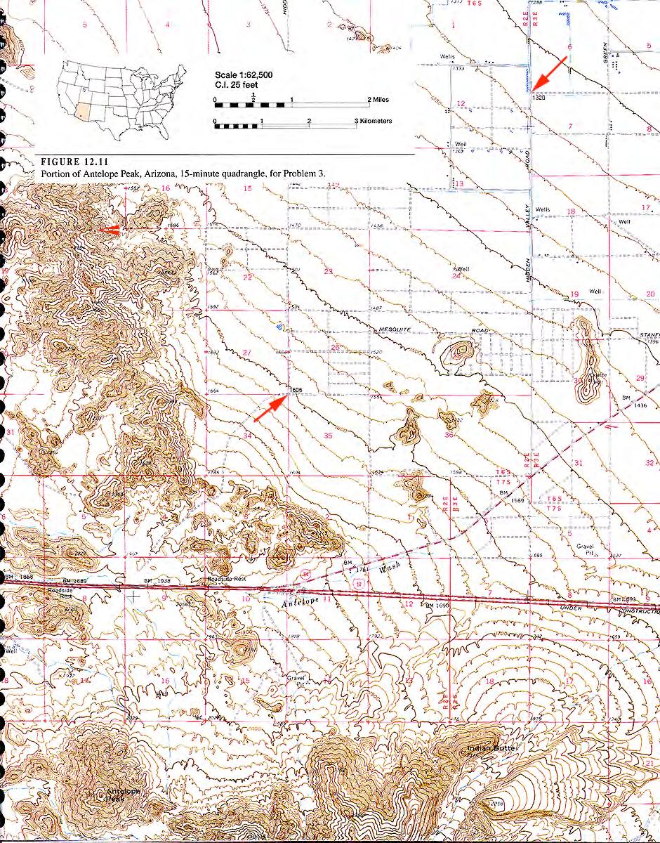
5 3) The map on Page 7 is a portion of the Antelope Peak, Arizona, quadrangle. U.S. Interstate 8 crosses the area on its way from San Diego, California, to Tucson, Arizona. The area is within the Basin and Range province, but the basin-bounding faults have long since been covered by alluvium. The piedmont is extensive and occupies a large part of the map area. The rocks exposed in the mountains in this quadrangle are mostly metamorphic and igneous rocks of Precambrian age. a) How does the map-view shape of the mountain front differ from the mountain fronts in the previous map and why? (3) b) Determine the gradient in feet/mile along a line extending from the southwest corner of Section 26 (near the center of the map) to the southwest corner of Section 6 (northeast corner of the map) (both are highlighted by red arrows). (4) How does the general contour pattern on the piedmont differ from the contour pattern on the western side of the map in Question 1 and why? (3) c) Note that the piedmont area north of the interstate is punctuated with a few hills to the northeast of the mountain front. What are they and how did they form? (3) What part of the piedmont lies between these hills and the mountain front? Explain. [Note: Figure 12.4 will be useful to look at]. (4) d) Based on the differences you have observed between the Antelope Peak and Death Valley areas, which area appears to have been subjected to erosion for the longest period without rejuvenation (for example, by tectonic activity or change in base level)? Give 2 pieces of evidence supporting your answer. (4) 5
6 e) Note the water wells in the northeast part of the map. In what part of the piedmont are they likely to be located? Why? (3) What is the probable origin of the groundwater tapped by the wells? Explain. (3) 6
7 7
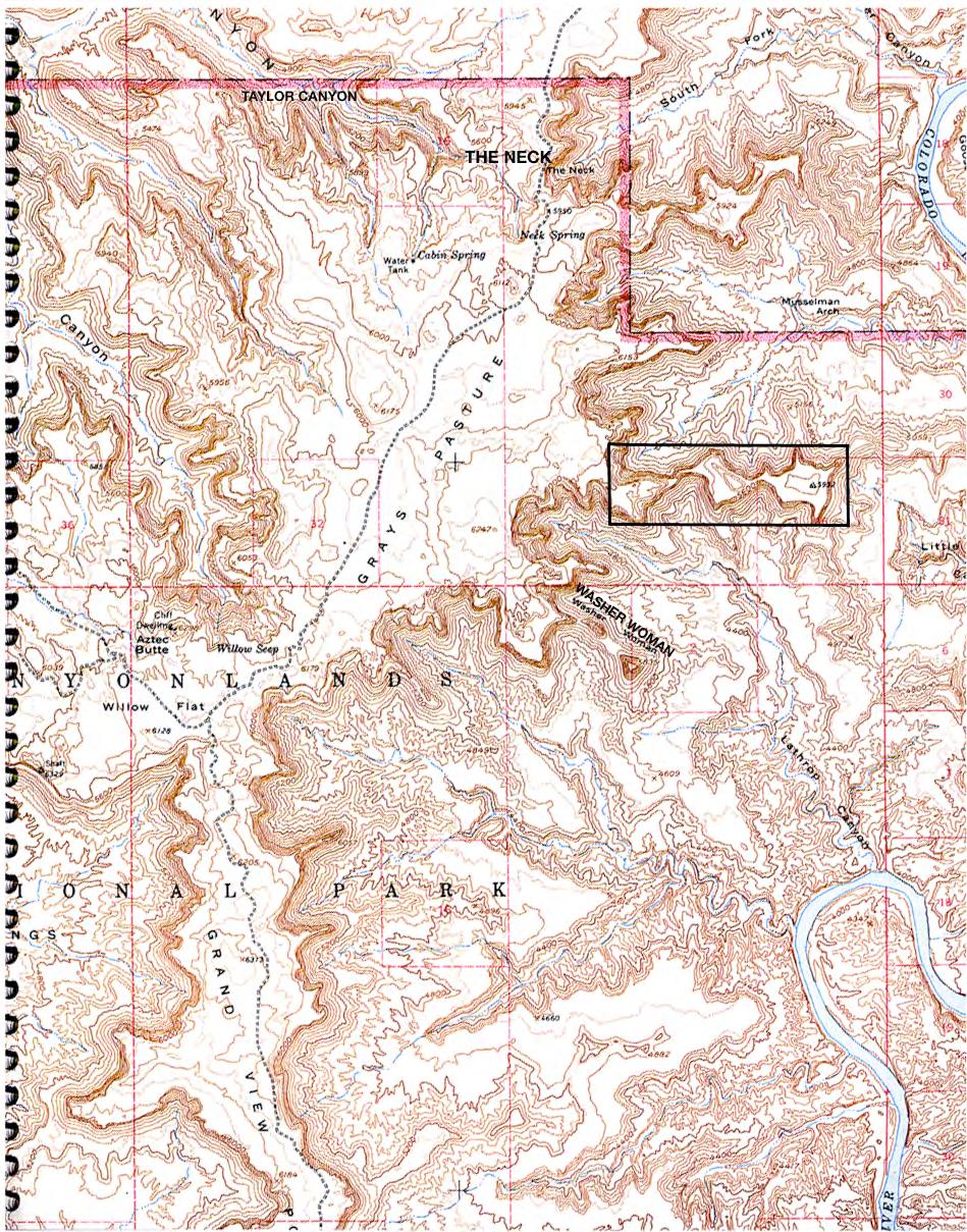
8 4) The map on Page 9 is a portion of the Upheaval Dome, Utah, 1:62,500 quadrangle. It is within Canyonlands National Park, an area with beautiful canyons cut by the Colorado and Green Rivers. Reddish sedimentary rocks, with nearly flat-lying layers, are carved into a series of cliffs and benches that gradually descend to the two rivers. a) Locate The Neck on the road just northeast of Grays Pasture. The Neck connects the plateau to the north to an area known as Island in the Sky. Island in the Sky is the Yshaped, relatively flat area that includes Grays Pasture, Grand View Point, and the unnamed area to the west. What is the approximate width of The Neck (in miles)? (2) With the head of Taylor Canyon to the west, and the South Fork of Shafer Canyon to the east, what erosional process will occur and what does the future hold in store for The Neck? (2) Should your prediction come true, what kind of landform will the Island-in-the-Sky area become? (1) b) Extending to the east of Grays Pasture are three, small, rather flat areas bounded by steep cliffs and connected by necks (outlined by a black box); the high point on the easternmost area is marked with its elevation of 5,932 feet. What landform name would be given to these areas if the necks were to be severed by erosion? Assume that their base is at 4,500 feet. (1) c) Washer Woman is just southeast of Grays Pasture. What type of landform is just south of the word Woman? (1) 8
9 9
Laboratory Exercise #4 Geologic Surface Processes in Dry Lands
 Page - 1 Laboratory Exercise #4 Geologic Surface Processes in Dry Lands Section A Overview of Lands with Dry Climates The definition of a dry climate is tied to an understanding of the hydrologic cycle
Continental Landscapes
 Continental Landscapes Landscape influenced by tectonics, climate & differential weathering Most landforms developed within the last 2 million years System moves toward an equilibrium Continental Landscapes
Geology 101 Lab Worksheet: Topographic Maps
 Geology 101 Lab Worksheet: Topographic Maps Name: Refer to the Topographic Maps Lab for the information you need to complete this worksheet (http://commons.wvc.edu/rdawes/g101ocl/labs/topomapslab.html).
2. What type of rocks would you expect in this area, based on the topography? What is your reasoning?
 Geology 101 Bonus Lab Name Topographic maps are useful in helping us interpret the history of the landscape of an area. The questions below are designed to help you learn to interpret topographic maps.
Physical Geology, 15/e
 Lecture Outlines Physical Geology, 15/e Plummer, Carlson & Hammersley Deserts & Wind Action Physical Geology 15/e, Chapter 13 Deserts Desert any arid region that receives less than 25 cm of precipitation
Unit 7.2 W.E.D. & Topography Test
 Name: Score: Unit 7.2 W.E.D. & Topography Test 1. 2. 3. 4. 5. 6. 7. 8. 9. 10. 11. 12. 13. 14. 15. 16. 17. 18. 19. 20. 21. 22. 23. 24. 25. 1. The formation of mountains is due mainly to while the destruction
Structural Geology Lab. The Objectives are to gain experience
 Geology 2 Structural Geology Lab The Objectives are to gain experience 1. Drawing cross sections from information given on geologic maps. 2. Recognizing folds and naming their parts on stereoscopic air
The Little Colorado River
 The Little Colorado River The Little Colorado River Junction of the Little Colorado River and the Colorado Grand Falls of the Little Colorado River The relief/topo map at the right shows the junction of
CASE STUDY #9 - Brushy Fork Dam, Sugar Grove, West Virginia
 CASE STUDY #9 - Brushy Fork Dam, Sugar Grove, West Virginia Brushy Fork Dam is a flood control structure built by the Soil Conservation Service southeast of the city of Franklin in Pendleton County, West
Structural Geology Lab. The Objectives are to gain experience
 Geology 2 Structural Geology Lab The Objectives are to gain experience 1. Drawing cross sections from information given on geologic maps. 2. Recognizing folds and naming their parts on stereoscopic air
STAAR Science Tutorial 40 TEK 8.9C: Topographic Maps & Erosional Landforms
 Name: Teacher: Pd. Date: STAAR Science Tutorial 40 TEK 8.9C: Topographic Maps & Erosional Landforms TEK 8.9C: Interpret topographic maps and satellite views to identify land and erosional features and
What type of land feature is located at Point A? A Cliff B Delta C Mountain D Valley
 1 What type of land feature is located at Point A? A Cliff B Delta C Mountain D Valley Alfred Wegener s theory of continental drift was 2 not accepted by scientists when the theory was first proposed.
Landforms and Rock Structure
 Landforms and Rock Structure Rock Structure as a Landform Control Landforms of Horizontal Strata and Coastal Plains Landforms of Warped Rock Layers Landforms Developed on Other Land-Mass Types Landforms
Earth s Layers. Earth s Surface
 CHAPTER 1 LESSON 3 Earth s Layers Earth s Surface Key Concepts What are Earth s major landforms and how do they compare? What are the major landform regions of the United States? What do you think? Read
Landforms. Why does the land look like it does? 1. Controlled by water 2. Controlled by the rocks
 Landforms Why does the land look like it does? 1. Controlled by water 2. Controlled by the rocks Landforms Made by Running Water Stream erosion The evolution of a river system Entrenched meanders Fluvial
every continent has an extensive dry region! " deserts are as much as 1/3 of Earth s surface!
 deserts! deserts! every continent has an extensive dry region! " deserts are as much as 1/3 of Earth s surface! Hollywood portrayal of vast stretches of sand dune! " Sahara has only 10% covered by sand!
Decoding Topographic Maps
 Name: Date: 1. Base your answer(s) to the following question(s) on the topographic map below and on your knowledge of Earth science. Letters A through F represent locations on the map. What is the contour
Laboratory Exercise #2 Introduction to Quadrangle Maps
 page - Laboratory Exercise #2 Introduction to Quadrangle Maps A. Introduction to Quadrangle Maps The United States Geological Survey has developed a nationwide series of quadrangle maps that cover small
UNIT 3 GEOLOGY VOCABULARY FLASHCARDS THESE KEY VOCABULARY WORDS AND PHRASES APPEAR ON THE UNIT 3 CBA
 UNIT 3 GEOLOGY VOCABULARY FLASHCARDS THESE KEY VOCABULARY WORDS AND PHRASES APPEAR ON THE UNIT 3 CBA A map that shows Earth s Topographic Map surface topography, which is Earth s shape and features Contour
Basin & Range / Mojave Desert
 Basin & Range / Mojave Desert Basin & Range vs. Great Basin 1 2/20/2016 An overview of the last horst Basin and Range / Mojave Desert Summary: Granitic, volcanic, marine sedimentary, non marine sedimentary,
Midterm Review. Nata/Lee
 Name: 1. Which statement best supports the theory that all the continents were once a single landmass? (1) Rocks of the ocean ridges are older than those of the adjacent sea floor. (2) Rock and fossil
Notes and Summary pages:
 Topographic Mapping 8.9C Interpret topographical maps and satellite views to identify land and erosional features and predict how these shapes may be reshaped by weathering ATL Skills: Communication taking
***When doing the lab report write-up, be sure to follow the guidelines.***
 Topographic Maps Lab Vocabulary: topography - study of the shapes and features of the earth's surface elevation - height above sea level bench mark - a point that has been accurately measured for its position
Elevations are in meters above mean sea level. Scale 1:2000
 12.001 LAB 7: TOPOGRAPHIC MAPS Due: Monday, April 11 PART I: CONTOURING AND PROFILES (20 PTS) 1. Contour this area map using a 5 meter contour interval. Remember some fundamental rules of contour lines,
The United States & Canada. A Regional Study of Anglo America
 A Regional Study of Anglo America Landform Regions of the United States & Canada world leaders in agricultural and industrial production because of... VAST LANDS stretch from the Atlantic Ocean on the
Relative Age-dating -- Discovery of Important Stratigraphic Principles
 Roger Steinberg Assistant Professor of Geology Del Mar College 101 Baldwin Corpus Christi, TX 78404 361-698-1665 rsteinb@delmaredu Abstract: When piecing together the geologic history of the Earth, geologists
Earth and Space: Topographic Maps Satellite Images
 Earth and Space: Topographic Maps Satellite Images Earth and Space: Formative Assessment Activities for Earth and Space Topographic Maps Satellite Images Teacher Pages Purpose The purpose of this station
Lab 9: Eolian and Arid Region Landforms
 Name: Lab 9: Eolian and Arid Region Landforms The objective of this lab is to familiarize yourself with a few basic desert and eolian landforms. Answer the following problems completely. You may need to
NEW YORK S NATURAL WONDERS
 Landscapes and Drainage Patterns NEW YORK S NATURAL WONDERS New York is not one of the largest states of the United States, nor does it have any large national parks to rival Yosemite or the Grand Canyon.
Relative Age-dating -- Discovery of Important Stratigraphic Principles Y
 R Steinberg DMC/4-08 EARTH HISTORY 1404 Example 1: Y S P Q Four different rock units (layers of different rock types), labeled Y, S, P, and Q, are seen in a road cut, as shown schematically above: 1) Are
44H1749S SCIENCE ACTIVITY HEADS IN, HEARTS IN. Creating Landforms. Instructions for Set-Up. Activity Preparation
 HEADS IN, HEARTS IN Creating Landforms Instructions for Set-Up Supplies Guide for Families handout 15 clear plastic standup displays (optional) Landforms handouts 13 disposable cookie sheets, 9-inch by
Upper Owyhee Watershed Assessment
 * Owyhee Watershed Council and Scientific Ecological Services The upper Owyhee subbasin is located in parts of three states: the southeastern corner of Oregon, the southwestern corner of Idaho, and north
8 th Grade Science Plate Tectonics and Topography Review
 8 th Grade Science Plate Tectonics and Topography Review #1 Scientists believe that the land masses of Earth were once joined together as one supercontinent called. A: Australia B: Wegner C: Pangaea D:
What is a landform? These shapes (except for bodies of water) on the earth s surface are all examples of landforms.
 on the earth s surface are all examples of landforms.") Landforms What is a landform? These shapes (except for bodies of water) on the earth s surface are all examples of landforms. archipelago a large group of many islands. The Hawaiian Islands Lighthouse
Landforms What is a landform? These shapes (except for bodies of water) on the earth s surface are all examples of landforms. archipelago a large group of many islands. The Hawaiian Islands Lighthouse
Topographic Maps and Landforms Geology Lab
 Topographic Maps and Landforms Geology Lab Ray Rector: Instructor Today s Lab Activities 1) Discussion of Last Week s Lab 2) Lecture on Topo Maps and Elevation Contours 3) Construct Topographic Maps and
Laboratory Exercise #2 Introduction to Quadrangle Maps
 page - 1 Laboratory Exercise #2 Introduction to Quadrangle Maps A. Introduction to Quadrangle Maps The United States Geological Survey has developed a nationwide series of quadrangle maps that cover small
Module 10: Resources and Virginia Geology Topic 4 Content: Virginia Geology Notes
 Virginia is composed of a very diverse landscape that extends from the beaches and barrier islands all of the way to the highly elevated Appalachian Plateau. Geologists have discovered ancient shallow
Unit 1: Geography. For additional information, refer to this website: 1 G e o g r a p h y
 Unit 1: Geography For additional information, refer to this website: http://mryoungtms.weebly.com/ 1 G e o g r a p h y Continents and Oceans SOL USI. 2a Essential Understanding: Continents are large land
MAPPING THE EARTH HOW DO YOU FIND A LOCATION ON THE EARTH?
 MAPPING THE EARTH HOW DO YOU FIND A LOCATION ON THE EARTH? UNIT TOPICS TOPIC 1: LATITUDE & LONGITUDE TOPIC 2: FIELD MAPS TOPIC 3: TOPOGRAPHIC MAPS TOPIC 4: NYS LANDSCAPES TOPIC 1: LATITUDE & LONGITUDE
What is a landform? These shapes (except for bodies of water) on the earth s surface are all examples of landforms.
 on the earth s surface are all examples of landforms.") Landforms What is a landform? These shapes (except for bodies of water) on the earth s surface are all examples of landforms. archipelago a large group of many islands. The Hawaiian Islands Lighthouse
Landforms What is a landform? These shapes (except for bodies of water) on the earth s surface are all examples of landforms. archipelago a large group of many islands. The Hawaiian Islands Lighthouse
Name: Mid-Year Review #2 SAR
 Name: Mid-Year Review #2 SAR Base your answers to questions 1 through 3 on on the diagram below, which shows laboratory materials used for an investigation of the effects of sediment size on permeability,
(version 3) I. HumAN -Environment Interaction
 I. HumAN -Environment Interaction") (version 3) I. HumAN -Environment Interaction A. Landforms 1. Earth s topography is made up of many different types of landforms. 2. While the planet is covered primarily with water, the four major types
(version 3) I. HumAN -Environment Interaction A. Landforms 1. Earth s topography is made up of many different types of landforms. 2. While the planet is covered primarily with water, the four major types
Rivers. Regents Earth Science Weathering & Erosion
 Regents Earth Science Weathering & Erosion Name: Rivers Use your notes, the handout Weathering and Erosion and your review book to answer the following questions on Rivers. Be sure to read the information
LAB N - FLUVIAL PROCESSES AND LANDSCAPES
 LAB N - FLUVIAL PROCESSES AND LANDSCAPES Introduction The objective of this lab is to familiarize the student with the work of running water (streams and rivers) and the landforms that they create. Materials
Page 1. Name:
 Name: 1) Which property would best distinguish sediment deposited by a river from sediment deposited by a glacier? thickness of sediment layers age of fossils found in the sediment mineral composition
Lab Topographic Maps. Name: Partner: Purpose. Background Information
 Lab Topographic Maps Name: Partner: Purpose The purpose of this lab is to familiarize you with graphic representations of the Earth s surface primarily maps. Simple line maps show the spatial relationship
EROSIONAL FEATURES. reflect
 reflect Have you ever looked at the land around you and wondered what processes shaped what you see? Perhaps you see mountains, valleys, rivers, or canyons. Do you know how long these geologic features
Erosional Features. What processes shaped this landscape?
 Have you ever looked at the land around you and wondered what processes shaped what you see? Perhaps you see mountains, valleys, rivers, or canyons. Do you know how long these geologic features have been
Pratice Surface Processes Test
 1. The cross section below shows the movement of wind-driven sand particles that strike a partly exposed basalt cobble located at the surface of a windy desert. Which cross section best represents the
Directed Reading. Section: How Mountains Form MOUNTAIN RANGES AND SYSTEMS. Skills Worksheet
 Skills Worksheet Directed Reading Section: How Mountains Form 1. How high is Mount Everest? a. about 1980 km above sea level b. more than 8 km below sea level c. more than 8 km above sea level d. more
Geologic Time Grand Canyon National Park
 Chapter 8: Geologic Time & the Grand Canyon Geologic Time Grand Canyon National Park Colorado Plateau nearly-horizontal rocks lifted feet above sea level River drains Mtns Who was John Wesley Powell? Label
Approximately how many inches of average yearly precipitation does Rochester, New York, receive?
 1. Base your answer to the following question on the isoline map below, which shows the average yearly precipitation, in inches, across New York State. Approximately how many inches of average yearly precipitation
12. LANDFORMS OF MASS WASTING
 Geomorphology 12. LANDFORMS OF MASS WASTING 40 Points The objective of this lab exercise is to learn how to identify landslides and earth flows using stereo-aerial photos in conjunction with topographic
5. The topographic map below shows a lake and two rivers.
 Mapping A B1 1. The diagram below shows latitude measurements every 10 degrees and longitude measurements every 15 degrees. What is the latitude and longitude of point X? 5. The topographic map below shows
Tuesday, September 05, 2017 Planet Earth
 Tuesday, September 05, 2017 Planet Earth Objective: Describe the solar system and Earth s location in it. Identify Earth s shape. Discuss Earth s structure. List Earth s landforms Do Now: What is a compass
Name. 4. The diagram below shows a soil profile formed in an area of granite bedrock. Four different soil horizons, A, B, C, and D, are shown.
 Name 1. In the cross section of the hill shown below, which rock units are probably most resistant to weathering? 4. The diagram below shows a soil profile formed in an area of granite bedrock. Four different
GY 301: Geomorphology Lab 3: Introduction to Topographic Maps; Coastal Geomorphology
 Name: Raw score: /65 Percentage: /100% GY 301: Geomorphology Your Task: Today s lab is your first opportunity to closely examine topographic maps. You will be asked to answer various questions about map
Copyright McGraw-Hill Education. All rights reserved. No reproduction or distribution without the prior written consent of McGraw-Hill Education
 Copyright McGraw-Hill Education. All rights reserved. No reproduction or distribution without the prior written consent of McGraw-Hill Education Tibetan Plateau and Himalaya -southern Asia 11.00.a VE 10X
In this lab, we will study and analyze geologic maps from a few regions, including the Grand Canyon, western Wyoming, and coastal California.
 Name: Lab Section: work in groups, but each person turns in his/her own GEOSCIENCE 001 LAB UNDERSTANDING GEOLOGIC MAPS Geologic maps are colorful and even beautiful, but they also contain an amazing amount
Pre-Lab Reading Questions ES202
 ES202 The are designed to encourage students to read lab material prior to attending class during any given week. Reading the weekly lab prior to attending class will result in better grade performance
What is weathering and how does it change Earth s surface? Answer the question using
 7 th Grade Lesson What is weathering and how does it change Earth s surface? Answer the question using the sentence frame. You have 4 minutes. Weathering is. This changes the Earth s surface because. 1
5. Compare the density of the oceanic crust to continental crust. 6. What kind of plate boundary is this? convergent
 The youngest rock is in the middle (at ridge) and it gets older on either side as you move away in a symmetrical pattern. 1. How does the age of the seafloor compare on either side of the ridge? A = youngest
Characteristics and processes associated with the development of Hilly Landscapes
 GRADE 11 GEOGRAPHY SESSION 1: GEOMORPHOLOGY I (TOPOGRAPHY) Key Concepts In this lesson we will focus on summarising what you need to know about: Topography associated with Horizontally Layered Rocks Topography
Cattaraugus Creek: A Story of Flowing Water and the Geology of the Channel It Flows Through Presentation to West Valley Citizen Task Force 4/27/16
 Cattaraugus Creek: A Story of Flowing Water and the Geology of the Channel It Flows Through Presentation to West Valley Citizen Task Force 4/27/16 Raymond C. Vaughan, Ph.D. What happens if you drop a
TOPOGRAPHIC RELIEF MAP of NYS. LANDFORMS of NYS. Landforms. Creation of NYS Landforms 9/22/2011
 TOPOGRAPHIC RELIEF MAP of NYS LANDFORMS of NYS Prof. Anthony Grande AFG 2011 Landforms The basis of present-day landforms (surface features) is the bedrock geology that has been worked on by the forces
Grade 5 Hands on Science Weathering, Erosion and Deposition
 Grade 5 Hands on Science Weathering, Erosion and Deposition Objective: To demonstrate and investigate the effect of weathering, water and wind erosion and the subsequent deposition into landforms. Background:
Topographic Maps. More than a Road Map
 Topographic Maps More than a Road Map What is a Topographic Map? Scaled representation of features on the surface of the Earth such as roads, rivers, and plains Provides information about land elevations
Read Across America. Listen as I read for facts about Volcanoes. In the Shadow of the Volcano
 Read Across America Listen as I read for facts about Volcanoes. In the Shadow of the Volcano Constructive & Destructive Processes Earth s surface is always changing. Blowing wind and flowing water causes
Guided Notes Topographic Maps
 Guided Notes Topographic Maps Map scale Straight line distance Curved line distance Rules of Isolines Contour Lines Hachured Lines Possible elevations Slope & Gradient Direction of River Flow Topographic
FOSSILS IN YOUR BACKYARD
 MOR BACKYARD 12 Activity Overview BIG IDEA OBJECTIVE BACKGROUND Millions of years ago, dinosaurs roamed all over our planet Why is it then that we only find dinosaurs in certain geographical locations?
Mount Everest and the Gobi Desert
 Mount Everest and the Gobi Desert 1 Mount Everest is part of the mountain chain known as the Himalaya. Adventurers from all over the world come to try to climb it. Mount Everest is the highest mountain
Which particle of quartz shows evidence of being transported the farthest distance by the stream? A) B) C) D)
 B) C) D)") 1. Base your answer to the following question on the block diagram below, which represents the landscape features associated with a meandering stream. WX is the location of a cross section. Location A
1. Base your answer to the following question on the block diagram below, which represents the landscape features associated with a meandering stream. WX is the location of a cross section. Location A
 Page 1 of 9 Name: Base your answer to the question on the diagram below. The arrows show the direction in which sediment is being transported along the shoreline. A barrier beach has formed, creating a
Geography Definitions/Sentences
 Geography Definitions/Sentences 1. BEACH 1. The shore of a body of water, especially when sandy or pebbly. 2. The sand or pebbles on a shore. The zone above the water line at a shore of a body of water,
Regents Earth Science Unit 1 Earth Dimensions
 Regents Earth Science Unit 1 Earth Dimensions www. BarnesWeb.org 2014-15 edition Name: Name: OBJECTIVES Correctly define: isolines, gradient, topographic map, contour interval, hachured lines, profile,
Space. Earth. EARTH and EARTH and SPACE SPACE. Earth. William B. Rice
 Space Earth rth EARTH and EARTH and SPACE SPACE SCIENCE Earth is covered with mountains, canyons, and oceans. These landforms change over time. Mountains are made. Valleys may become deeper. Earth s landforms
Changes over Time: Destructive Processes
 1 Name Date Changes over Time: Destructive Processes Earth s surface is always changing. Blowing wind and flowing water causes some changes. Moving rock deep inside Earth causes other changes. These processes
Section 10.1 The Nature of Volcanic Eruptions This section discusses volcanic eruptions, types of volcanoes, and other volcanic landforms.
 Chapter 10 Section 10.1 The Nature of Volcanic Eruptions This section discusses volcanic eruptions, types of volcanoes, and other volcanic landforms. Reading Strategy Previewing Before you read the section,
SESSION 9: CLIMATE AND WEATHER, FLUVIAL PROCESSES AND MAPWORK
 SESSION 9: CLIMATE AND WEATHER, FLUVIAL PROCESSES AND MAPWORK KEY CONCEPTS: In this session we will: Integrate theory and mapwork. Look specifically at how climate and weather and fluvial processes can
Possible Confusion in Identifying Surficial Planation Surfaces
 Appendix 15 Possible Confusion in Identifying Surficial Planation Surfaces Planation surfaces generally are easy to recognize (see Chapter 32), when we remember they have been modified by both Flood and
Ge Problem Set 1
 Ge 101 2012 Problem Set 1 This problem set covers basic techniques in structural geology, geomorphology and the construction of cross sections. Questions 2 and 3 are simple exercises; 1 and 4 are reallife
a division of Teacher Created Materials
 Sample Pages from a division of Teacher Created Materials Thanks for checking us out. Please call us at 877-777-3450 with questions or feedback, or to order this product. You can also order this product
East Penn School District Curriculum and Instruction
 East Penn School District Curriculum and Instruction Curriculum for: Geology of National Parks Course(s): Geology of the National Parks Grades: 10-12 Department: Science Length of Period (average minutes):
Each basin is surrounded & defined by a drainage divide (high point from which water flows away) Channel initiation
 Channel initiation") DRAINAGE BASINS A drainage basin or watershed is defined from a downstream point, working upstream, to include all of the hillslope & channel areas which drain to that point Each basin is surrounded &
DRAINAGE BASINS A drainage basin or watershed is defined from a downstream point, working upstream, to include all of the hillslope & channel areas which drain to that point Each basin is surrounded &
Extra Credit Assignment (Chapters 4, 5, 6, and 10)
") GEOLOGY 306 Laboratory Instructor: TERRY J. BOROUGHS NAME: Extra Credit Assignment (Chapters 4, 5, 6, and 10) For this assignment you will require: a calculator and metric ruler. Chapter 4 Objectives:
GEOLOGY 306 Laboratory Instructor: TERRY J. BOROUGHS NAME: Extra Credit Assignment (Chapters 4, 5, 6, and 10) For this assignment you will require: a calculator and metric ruler. Chapter 4 Objectives:
Chapter 10: Volcanoes and Other Igneous Activity Section 1: The Nature of Volcanic Eruptions I. Factors Affecting Eruptions Group # Main Idea:
 Chapter 10: Volcanoes and Other Igneous Activity Section 1: The Nature of Volcanic Eruptions I. Factors Affecting Eruptions Group # A. Viscosity Group # B. Dissolved Gases Group # II. Volcanic Material
Physiographic Provinces (West, Ch. 13)
") Geology 229 Engineering Geology Lecture 13 Physiographic Provinces (West, Ch. 13) The definition of the term Physiography Physiography (n.) The science which treats of the earth's exterior physical features,
Geology 229 Engineering Geology Lecture 13 Physiographic Provinces (West, Ch. 13) The definition of the term Physiography Physiography (n.) The science which treats of the earth's exterior physical features,
Surface Process Hazards Unit 2: Landscape Feature Scavenger Hunt
 Surface Process Hazards Unit 2: Landscape Feature Scavenger Hunt Sarah Hall (College of the Atlantic) and Becca Walker (Mt. San Antonio College) The following pages each have a series of questions about
Unit 3 Review - Surface Processes
 Unit 3 Review - Surface Processes 1. Why is the surface of Mercury covered with meteor impact craters, while Earth s surface has relatively few craters? A) Mercury is larger than Earth, so it gets hit
SCI-5 KES 5.7 Geology Post-test Exam not valid for Paper Pencil Test Sessions
 SCI-5 KES 5.7 Geology Post-test Exam not valid for Paper Pencil Test Sessions [Exam ID:1D5NLH 1 Earth's crust is made of plates that move slowly. This movement changes the appearance of the Earth's crust
Earth Science. STREAM DRAINAGE PATTERNS (start by reading the first page of these notes!)
") Name _ Earth Science STREAM DRAINAGE PATTERNS (start by reading the first page of these notes!) WHAT IS A DRAINAGE PATTERN? Streams seek the lowest path as they move downhill, and they tend to erode their
Name _ Earth Science STREAM DRAINAGE PATTERNS (start by reading the first page of these notes!) WHAT IS A DRAINAGE PATTERN? Streams seek the lowest path as they move downhill, and they tend to erode their
ENGINEER S CERTIFICATION OF FAULT AREA DEMONSTRATION (40 CFR )
") PLATTE RIVER POWER AUTHORITY RAWHIDE ENERGY STATION BOTTOM ASH TRANSFER (BAT) IMPOUNDMENTS LARIMER COUNTY, CO ENGINEER S CERTIFICATION OF FAULT AREA DEMONSTRATION (40 CFR 257.62) FOR COAL COMBUSTION RESIDUALS
PLATTE RIVER POWER AUTHORITY RAWHIDE ENERGY STATION BOTTOM ASH TRANSFER (BAT) IMPOUNDMENTS LARIMER COUNTY, CO ENGINEER S CERTIFICATION OF FAULT AREA DEMONSTRATION (40 CFR 257.62) FOR COAL COMBUSTION RESIDUALS
2. PHYSICAL SETTING FINAL GROUNDWATER MANAGEMENT PLAN. 2.1 Topography. 2.2 Climate
 FINAL GROUNDWATER MANAGEMENT PLAN 2. PHYSICAL SETTING Lassen County is a topographically diverse area at the confluence of the Cascade Range, Modoc Plateau, Sierra Nevada and Basin and Range geologic provinces.
A) greatest in diameter at the Equator C) 53 N B) Albany D) 13.8 billion years B) cosmic background radiation
 greatest in diameter at the Equator C) 53 N B) Albany D) 13.8 billion years B) cosmic background radiation") 1. Measurements taken from space show the Earth to be A) greatest in diameter at the Equator B) greatest in diameter at the poles C) a perfect sphere D) pear shaped 2. The diagram below represents an observer
1. Measurements taken from space show the Earth to be A) greatest in diameter at the Equator B) greatest in diameter at the poles C) a perfect sphere D) pear shaped 2. The diagram below represents an observer
Geomorphology Final Exam Study Guide
 Geomorphology Final Exam Study Guide Geologic Structures STRUCTURAL GEOLOGY concerned with shapes, arrangement, interrelationships of bedrock units & endogenic (within) forces that cause them. Tectonic
B. Topographic maps are also called. contour maps
 Topographic Maps Introduction A. Topographic maps are essential tools in geologic and engineering studies because they show the configuration of Earth's surface in remarkable detail and permit one to measure
Prentice Hall EARTH SCIENCE
 Prentice Hall EARTH SCIENCE Tarbuck Lutgens Chapter 7 Glaciers, Desert, and Wind 7.1 Glaciers Types of Glaciers A glacier is a thick ice mass that forms above the snowline over hundreds or thousands of
discussion of North America s physical features, including its landforms and bodies of
 Chapter 7 Natural Environments of North America Chapter 7 focuses on the natural environments of North America. The chapter opens with a discussion of North America s physical features, including its landforms
4. The map below shows a meandering stream. Points A, B, C, and D represent locations along the stream bottom.
 1. Sediment is deposited as a river enters a lake because the A) velocity of the river decreases B) force of gravity decreases C) volume of water increases D) slope of the river increases 2. Which diagram
APPENDIX A GLOSSARY. Appendix A.1
 APPENDIX A GLOSSARY Appendix A.1 Appendix A.2 Back Bearing A back bearing is measured from the object to your position. It is the exact opposite of a direct bearing. Base Line An imaginary line on the