Topographic Maps and Landforms Geology Lab
|
|
|
- Osborn Wright
- 5 years ago
- Views:
Transcription
1 Topographic Maps and Landforms Geology Lab Ray Rector: Instructor
2 Today s Lab Activities 1) Discussion of Last Week s Lab 2) Lecture on Topo Maps and Elevation Contours 3) Construct Topographic Maps and Profiles 4) Analyze Topographic Maps of Yosemite Valley 5) Prepare for Next Week s Lab Recommended Pre-Lab Web Activities 1) Visualizing Earth s Topography 2) Understanding Topographic Maps 3) Making a Simple Contour Map
3 Purpose of Today s Lab 1) Become familiar with the fundamentals of topographic maps and landforms 2) Preparation for next week s lab on Structural Geology and Using and Making Geologic Maps Learning Outcomes When you are finished today, you should be able to: 1) familiar the concepts of scale, location (latitude and longitude), elevations, depths and contour lines. 2) identify the type, shape, and steepness of landforms 3) create s simple contour map from elevation point data 4) draw a cross-section profile
4 Many Types of Maps 1) Topographic Maps 2) Bathymetry Maps 3) Nautical Charts 4) Geology Maps 5) Road Maps 6) Political Maps 7) Climate Maps 8) Ecosystem Maps Surface Height Maps
5 What is a Topographic Map? 1) An abstract, 2-dimensional, scaled-down graphic representation of the shape of the land. 2) Topo maps illustrate location, scale, width, length, and height of land surfaces. 3) Elevations of land surface are symbolized by contour lines which signify lines of equal elevation (termed isopleths). 4) Topo maps also show other features like rivers, streams, trails, roads, and buildings. Next: Let s compare a Topo map to a Bathymetric Chart?

6 A Topographic Map Images the Ground

7 Example of a Topographic Map Close-up View


8 Example of a Orthoquad Map
9 Importance of Topographic Maps to Geologists and Geographers 1) Navigation and Orienteering 2) Geologic Studies Geologic Mapping and Sampling 3) Geographic Studies 4) Engineering Projects
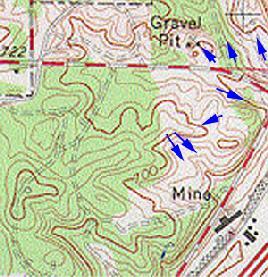
10 Key Concepts of Topographic Maps 1) Map Projection 2) Compass Directions N-S, E-W 3) Location Longitude-Latitude and UTM 4) Map Scale Fractional, Verbal and Bar 5) Magnetic Declination 6) Map Series / Map Name 7) Map Symbols 8) Elevation Contour Lines

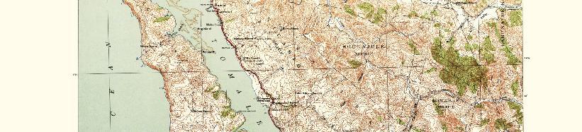
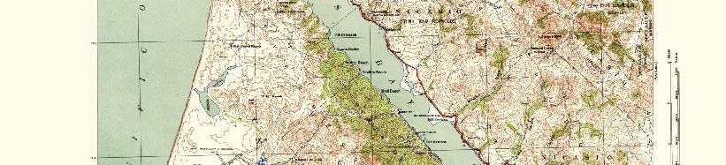
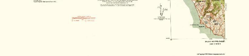
11 Point Reyes 19 x 15 Quadrangle
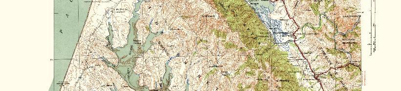
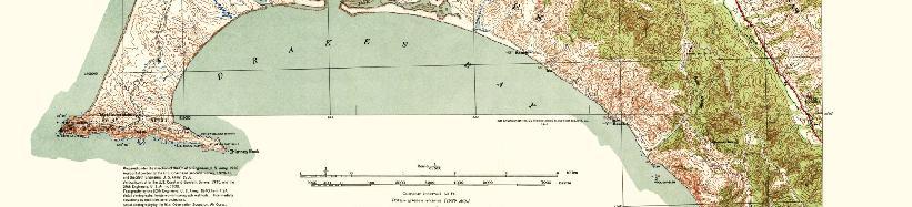
12 Drakes Bay 7.5 x 7.5 Quadrangle

13 Map Projections 1) Transferring a Curved Surface to a Flat Surface Cannot avoid distortion Numerous methods Each method has a specific type of distortion Each method preserves a correct aspect of the earth s surface

14 Map Projections 1) Transferring a Curved Surface to a Flat Surface Cannot avoid distortion Numerous methods Each method has a specific type of distortion Each method preserves a correct aspect of the earth s surface


15 Various Map Projections 1) Preserve Direction/Angle Directions preserved Area is distorted Example is Mercator Popular projection 2) Preserve Area-Shape Preserves area size and shape Direction/angle is distorted Example is Albers Less popular projection


16 Geographic Orientation of Maps 1) Compass direction of maps: True North points toward Top Due South points toward Bottom Due East points to the Right Due West points to the Left 2) Note that a compass points to Magnetic North Magnetic declination information should be found in the map legend = true north MN = magnetic north GN = grid north


17 Finding One s Position on the Earth s Surface Latitude and Longitude: A Global Coordinate System Lines of Latitude: N S Position Latitude: Equator = 0o Poles = 90o N and S Longitude: Prime Meridian = 0o IDL = 180o W and E Lines of Longitude: W E Position


18 Finding One s Position on the Earth s Surface Latitude and Longitude: A Global Coordinate System Lines of Longitude Lines of Latitude

19 Universal Transverse Mercator (UTM): Another Global Coordinate System Earth Divided into 60 6º degree Longitudinal UTM Zones

20 Finding One s Position on the Earth s Surface Universal Transverse Mercator (UTM): Another Global Coordinate System UTM Zones Easting Northing: The number of meters north of the equator the location lies UTM map grid is divided Easting: The number of meters into 1000 meter squares. This may be printed or east from the west side of the not printed over the map local zone the location lies


21 Universal Transverse Mercator (UTM): Another Global Coordinate System UTM Zones, Northing and Easting on a Topo Map Northing values on the sides of the map Easting values on the top and bottom of the map Using a UTM Grid template overlay on a Topo Map
22 Map Scale 1) All maps are drawn to a specific scale 2) Distances on the map are proportional to distances on the ground 3) For example, 1 inch distance on a map with a 1:62,500 scale will represent 62,5000 inches of real ground distance, which translate to about 1 inch to 1 mile. 4) There are three ways to express map scale: Fractional scale: 1:62,500 Verbal scale: 1 inch (map) equals 1 mile (ground) Bar scale: 5) Only bar scale stays accurate if the map shrunk or enlarged
23 Map Series Examples USGS Topographic Maps 7.5-minute maps 15-minute maps 1:100,000-scale series County map series 1:250,000-scale series State map series National park map series Shaded-relief maps Topographic-bathymetric maps Antarctic maps NOAA Bathymetry Maps Coastal Fishing Global Lakes Multibeam NOS surveys Trackline

24 Understanding Contour Lines 1) Contours are imaginary lines that join points of equal elevation on the surface of the land above or below a reference surface, such as sea level. Click Me 2) Contours make it possible to measure the height of mountains, depths of the ocean bottom, and steepness of slopes.

25 Map with Topography and Bathymetry
26 How to Make a Simple Contour Map 1) Start with a set of locations that have been measured for a certain surface attribute: Ex: elevation or water depth 2) Set a contour interval, based on range of values mapped 3) Draw a contour line for each interval multiple 4) Each contour must be drawn between higher and lower point values or on exact values 5) Interpolate between the high and low value where the contour line should be positioned Click here for Internet example
27 Contouring Exercises
28 Contouring Exercises
29 Contouring Exercises
 Bull s Eye contour pattern indicate a peak or basin Center of bull s eye is highest point =")
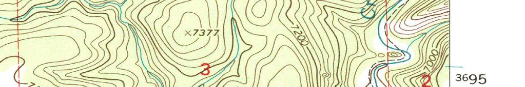
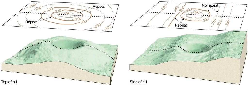
30 Rules of Contour Line 1) Contour lines never cross 2) Widely spaced contours indicate a gradual slope 3) Tightly-spaced lines indicate a steep slope 4) V -shaped contour pattern indicate either a valley or ridge line The V points toward higher area = valley The V points toward lower area = ridge 5) Bull s Eye contour pattern indicate a peak or basin Center of bull s eye is highest point = peak Center of bull s eye is lowest point = basin
31

32 Example for Understanding Contour Rules Valleys Peak Ridges Not Steep Steep
 Valleys 3) Steep terrain 5) Peak tops 2) Ridges 4) Not Steep terrain 6) Total relief of")
33 Can You Point Out These Features? 1) Valleys 3) Steep terrain 5) Peak tops 2) Ridges 4) Not Steep terrain 6) Total relief of map Question: Which way does the river flow? North or South?
34

35 Contours Line Patterns and Landforms Match the Contours Line Patterns with the Hill Shape
 Distance from One Point to Another along a Straight Line 2) Converting from Map Distance to Real Ground Distance Going From Point \"A\" to")
36 Determining Map Bearing and Distance Understand Map Direction 1) Cardinal Directions 2) Azimuth versus Quadrant Notation 3) Difference between True Bearing Versus Magnetic Bearing Understand Map Distance 1) Distance from One Point to Another along a Straight Line 2) Converting from Map Distance to Real Ground Distance Going From Point "A" to "B"
 Measure the bearing as either an azimuth or a quadrant")
37 Determining True Bearing from One Location Point to Another Three Basic Steps 1) Locate your present position 2) Locate the position you want to establish a bearing to 3) Use a properly positioned protractor to determine the true bearing from your location to the other position 4) Measure the bearing as either an azimuth or a quadrant bearing
 Measure the bearing as either an azimuth or a quadrant")
38 Determining Magnetic Bearing from One Location Point to Another Four Basic Steps 1) Locate your present position 2) Locate the position you want to establish a bearing to 3) Use a properly positioned compass to determine the magnetic compass bearing from your location to the other position 4) Measure the bearing as either an azimuth or a quadrant bearing
 Plot the bearing lines on your map with the bearing lines crossing through the sighted landforms 4) Where the bearing lines intersect is your triangulated")
39 Determining Your Location Using Triangulation Four Basic Steps 1) Locate several local prominent landforms by sight, such as a peak top or 2) Take (shoot) a compass bearing to each landform and note value 3) Plot the bearing lines on your map with the bearing lines crossing through the sighted landforms 4) Where the bearing lines intersect is your triangulated location
40 Creating Topographic Profiles Three Basic Steps 1) Copying contour map data onto paper strip 2) Transferring paper strip contour data onto labeled profile graph as a set of dots 3) Connecting the dots together as a smooth line
41 Poway, Ca 7 ½ Minute Topo Map
42 Creating a Topographic Profile Step 1 Mark and label a continuous set of elevation/depth contour points along a predetermined transverse across the map onto a strip of paper You will then use the strip of paper with the contour information to create a crosssection profile of the map transverse on a piece of graph paper
43 Creating a Topographic Profile Step 2 Transfer contour info from strip of paper onto properly labeled graph paper as a set of dots that mark elevation or depth Step 3 Connect profile elevation or depth dots with a smooth line this is your profile
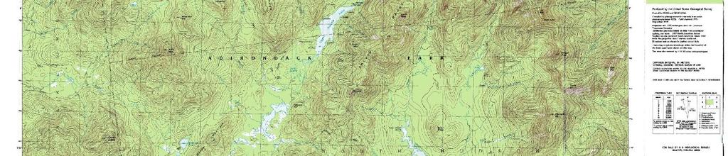
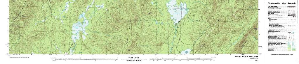
44 Yosemite Valley Topography
")
 El Capitan to Cathedral")
45 Yosemite Valley Topographic Map Cross-Section Profiles 1) Mount Watkins to Clouds Rest 2) El Capitan to Cathedral Rocks


46 Views of Yosemite Valley

47 Views of Yosemite Valley

48 Views of Yosemite Valley

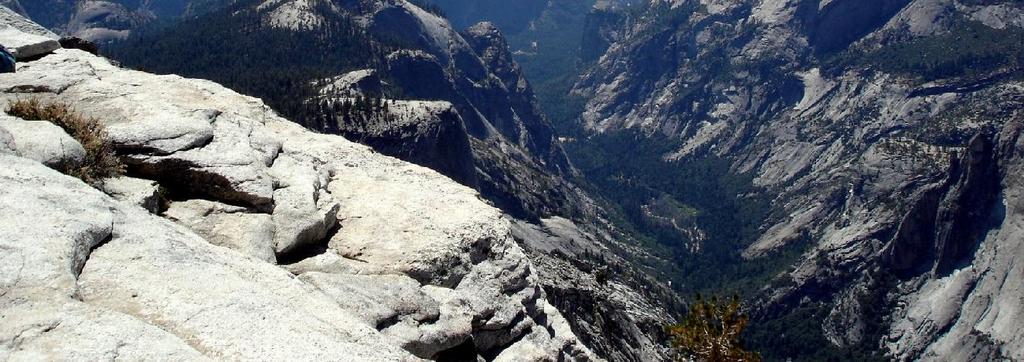
49 Views of Yosemite Valley

50 Views of Yosemite Valley
51 Head s-up for Next Week s Lab Structure and Earthquakes Next Week s Lab Activities 1) Strike and Dip 2) Folds and Faults 3) Measure Epicenter and Magnitude 4) Ground Motion Experiment 5) Measure Fault Displacement Preparation Recommended Pre-Lab Web Activities (Click on Link) 1) Learn About Earthquakes - USGS Site 2) Virtual Earthqauke! 3) World ocean bottom features and Tectonic plate boundaries
52 Head s-up for Next Week s Lab Topographic Maps II Next Week s Lab Activities 1) Yosemite Valley Topo Map 2) Location, Distance and Bearing 3) Triangulating for Location 4) Create Topographic Profile
Chapter 3 Models of the Earth. 3.1 Finding Locations on the Earth. 3.1 Objectives
 Chapter 3 Models of the Earth 3.1 Finding Locations on the Earth 3.1 Objectives Explain latitude and longitude. How can latitude and longitude be used to find locations on Earth? How can a magnetic compass
Compass Basics. Quick Map Basics Review For Compass Use
 Compass Basics Quick Map Basics Review For Compass Use A topographic map tells you where things are and how to get to them, whether you're hiking, biking, hunting, fishing, or just interested in the world
APPENDIX A GLOSSARY. Appendix A.1
 APPENDIX A GLOSSARY Appendix A.1 Appendix A.2 Back Bearing A back bearing is measured from the object to your position. It is the exact opposite of a direct bearing. Base Line An imaginary line on the
Navigating with Map & Compass. Nevada County Sheriff s Search & Rescue
 Navigating with Map & Compass Nevada County Sheriff s Search & Rescue Objectives Very Practical Teach you how to go from point A to point B Go from the wilderness (real world) to a map and visa versa Agenda
What is a map? A Map is a two or three-dimensional model or representation of the Earth s surface. 2-Dimensional map
 What is a map? A Map is a two or three-dimensional model or representation of the Earth s surface. 2-Dimensional map What is a Map Projection? Planar Projection Projection A Projection is a mathematical
Using Map and Compass Together
 Using Map and Compass Together In situations where you foresee a potential evacuation on foot, where there are no roads, and no indication as to the direction of travel (i.e., road signs), it is recommended
Mapping Earth. How are Earth s surface features measured and modeled?
 Name Mapping Earth How are Earth s surface features measured and modeled? Before You Read Before you read the chapter, think about what you know about maps Record your thoughts in the first column Pair
Laboratory Exercise #2 Introduction to Quadrangle Maps
 page - Laboratory Exercise #2 Introduction to Quadrangle Maps A. Introduction to Quadrangle Maps The United States Geological Survey has developed a nationwide series of quadrangle maps that cover small
Laboratory Exercise #2 Introduction to Quadrangle Maps
 page - 1 Laboratory Exercise #2 Introduction to Quadrangle Maps A. Introduction to Quadrangle Maps The United States Geological Survey has developed a nationwide series of quadrangle maps that cover small
Basic Map Skills for the Outdoors
 Geography 80-20 80% of what there is to know, for 20% of the sweat Basic Map Skills for the Outdoors Map Scale Map source: US Geological Survey Four ways to indicate map scale: Representative fraction
Butte County Fire Department
 Butte County Fire Department Basic Land Navigation Verification Sheet I verify that Print Supervisor s name has completed the Print Employee s name Basic Land Navigation self study guide on. Date Attached
Topographic Map Series:
 DEFINITION OF A MAP A MAP IS A GEOGRAPHIC PREPRESENTATION OF A PORTION OF THE EARTH S SURFACE DRAWN TO SCALE, AS SEEN FROM ABOVE. IT S USES COLORS, SYMBOLS AND LABELS TO REPRESENT FEATURES FOUND ON THE
Lab Topographic Maps. Name: Partner: Purpose. Background Information
 Lab Topographic Maps Name: Partner: Purpose The purpose of this lab is to familiarize you with graphic representations of the Earth s surface primarily maps. Simple line maps show the spatial relationship
B. Topographic maps are also called. contour maps
 Topographic Maps Introduction A. Topographic maps are essential tools in geologic and engineering studies because they show the configuration of Earth's surface in remarkable detail and permit one to measure
Topographic Maps Self-Instruction Lab (2016 edition) Geology 100 David Harbor s Section. 12 inches x 1 mile
 Geology 100 David Harbor s Section. 12 inches x 1 mile") Topographic Maps Name Self-Instruction Lab (2016 edition) Geology 100 David Harbor s Section Topographic maps are an important aid for a geologist, but maps are also useful for hikers, bicyclists, and
Topographic Maps Name Self-Instruction Lab (2016 edition) Geology 100 David Harbor s Section Topographic maps are an important aid for a geologist, but maps are also useful for hikers, bicyclists, and
AS 410 Land Navigation. Chpt 4-1
 AS 410 Land Navigation Chpt 4-1 Overview Types of Maps Map Legends / Scales Latitude and Longitude Orienteering Why? Why important to learn how to read a compass and map? No cell phone coverage Mountain
USING THE MILITARY LENSATIC COMPASS
 USING THE MILITARY LENSATIC COMPASS WARNING This presentation is intended as a quick summary, and not a comprehensive resource. If you want to learn Land Navigation in detail, either buy a book; or get
Name Class Date. For each pair of terms, explain how the meanings of the terms differ.
 Skills Worksheet Chapter Review USING KEY TERMS For each pair of terms, explain how the meanings of the terms differ. 1. true north and magnetic north 2. latitude and longitude 3. equator and prime meridian
King County Explorer Search and Rescue. Course B Map & Compass
 King County Explorer Search and Rescue Course B Map & Compass Disclaimer The intent of this presentation is to provide a basic overview of maps, compasses, and location finding. It is not meant to be a
MAPPING THE EARTH HOW DO YOU FIND A LOCATION ON THE EARTH?
 MAPPING THE EARTH HOW DO YOU FIND A LOCATION ON THE EARTH? UNIT TOPICS TOPIC 1: LATITUDE & LONGITUDE TOPIC 2: FIELD MAPS TOPIC 3: TOPOGRAPHIC MAPS TOPIC 4: NYS LANDSCAPES TOPIC 1: LATITUDE & LONGITUDE
Earth Science Unit 1 Test
 Earth Science Unit 1 Test Multiple Choice Identify the choice that best completes the statement or answers the question. 1. The study of meteorology involves the study of a. climate. c. animals. b. outer
Different types of maps and how to read them.
 Different types of maps and how to read them. A map is a picture or representation of the Earth's surface, showing how things are related to each other by distance, direction, and size. Maps have been
Date: UNI. world. *Dedicated to
 Name: Date: UNI IT THREE 2D and 3D model s of the natural world *Dedicated to Name: Date: ABSTRACT T AND RATIONALE A topographic map is a type of map that depicts the detail and quantitative representation
56H. This system allows definition of points on the Earth s surface to within 100 meters. Page 20. Navigation Systems Basics of Maps
 Grid References Many maps are provided with the standard grid overlaying them. This provides a simple and accurate method for finding features on the map. It is a network of intersecting parallel lines
REVISION: MAPWORK 18 SEPTEMBER 2014
 REVISION: MAPWORK 18 SEPTEMBER 2014 Lesson Description In this lesson we revise: Various mapwork calculations Summary Relative Position Bearing is the angular (angle) distance between two points True Bearing
EPSS 15. Spring Introduction to Oceanography. Laboratory #1 Maps, Cross-sections, Vertical Exaggeration, Graphs, and Contour Skills 4/7/17
 EPSS 15 Spring 2017 Introduction to Oceanography Laboratory #1 Maps, Cross-sections, Vertical Exaggeration, Graphs, and Contour Skills MAPS Provide valuable interface to explore the geography of the world
Latitude and Longitude
 U n i t 3 M a p p i n g P a g e 1 Latitude and Longitude Note: These coordinates are always expressed LATITUDE/LONGITUDE!!! Coordinate System: Using and to find your position on Earth. LATITUDE LATITUDE
Chapter 3 SECTION 1 OBJECTIVES
 Chapter 3 SECTION 1 OBJECTIVES Distinguish between latitude and longitude and locate coordinates on maps. Explain how latitude and longitude can be used to locate places on Earth s surface. Explain the
Butte County Fire Department
 Butte County Fire Department Basic Land Navigation Verification Sheet I verify that Print Supervisor's name Print Employee's name has completed the Basic Land Navigation self study guide on Date Attached
Introduction to Contour Maps
 Your web browser (Safari 7) is out of date. For more security, comfort and Activityengage the best experience on this site: Update your browser Ignore Introduction to Contour Maps What information does
Map Reading & Compass Use
 Spring 2013 Kestrel Land Trust Page 2 / 10 Contents Map Basics... 3 Map Types... 3 Terrain Association... 4 Estimating Distance: Pacing... 4 Contour Lines... 5 Navigating with a Compass... 6 Compass Types...
CHAPTER EXIT CHAPTER. Models of Earth. 3.1 Modeling the Planet. 3.2 Mapmaking and Technology. 3.3 Topographic Maps CHAPTER OUTLINE
 EXIT CHAPTER.1 Modeling the Planet.2 Mapmaking and Technology. Topographic Maps CHAPTER OUTLINE CHAPTER.1 Modeling the Planet A flat of Earth is a convenient tool, but it can distort the shape, distance,
What Is a Globe? Hemispheres. Main Idea Globes and maps provide different ways of showing features of the earth. Terms to Know
 r Main Idea Globes and maps provide different ways of showing features of the earth. Terms to Know hemisphere latitude longitude scale bar scale relief elevation contour line What Is a Globe? A globe is
Mapping Earth. Technology and Mapmaking
 CHAPTER 1 LESSON 2 Mapping Earth Technology and Mapmaking Key Concepts What can a topographic map tell you about the shape of Earth s surface? What can you learn from geologic maps about the rocks near
1. Label a few examples of lines of latitude and lines of longitude on the globe above left.
 Oceanography 2 Location, Direction, and Distance on Nautical Charts Please read Appendix III in the textbook for reference. Learning Objectives for the first nautical chart Lab 1. Use the latitude-longitude
Earth Science Regents Reading Topographic Maps
 Earth Science Regents Reading Topographic Maps Name Period Quick Tutorial on Degrees, Minutes, and Seconds of Latitude and Longitude A degree of latitude on the surface of the earth is about 70 miles long.
Your work from these three exercises will be due Thursday, March 2 at class time.
 GEO231_week5_2012 GEO231, February 23, 2012 Today s class will consist of three separate parts: 1) Introduction to working with a compass 2) Continued work with spreadsheets 3) Introduction to surfer software
USING THE MILITARY LENSATIC COMPASS
 USING THE MILITARY LENSATIC COMPASS WARNING This presentation is intended as a quick summary, and not a comprehensive resource. If you want to learn Land Navigation in detail, either buy a book; or get
Class Notes: Mapping the Earth
 Name: Date: Period: Mapping the Earth The Physical Setting: Earth Science Class Notes: Mapping the Earth I. Latitude and Longitude Map -! Latitude -! Also called These lines intersect Equator -! The North
Mapping Our World Chapter 2
 Mapping Our World Chapter 2 Section 2.1: Latitude and Longitude Maps are flat models of threedimensional objects. For thousands of years people have used maps to define borders and to find places. With
Lab # - Ocean Bottom Topography. Background Information:
 Name Lab Grade /10 Date Period Lab # - Ocean Bottom Topography Background Information: Ocean depth varies markedly from one location to another. Over large areas water depth is less than 200m (650 ft);
STAAR Science Tutorial 40 TEK 8.9C: Topographic Maps & Erosional Landforms
 Name: Teacher: Pd. Date: STAAR Science Tutorial 40 TEK 8.9C: Topographic Maps & Erosional Landforms TEK 8.9C: Interpret topographic maps and satellite views to identify land and erosional features and
Topographic Maps Lab 1
 Topographic Maps Lab 1 I. Objectives 1. Construct a material model of typical terrain found in a landscape. 2. Construct a topographic map corresponding to the terrain model. 3. Learn how to interpret
Orienteering Maps & Map Reading Latitude and Longitude Scale
 Orienteering Maps & Map Reading A map is a two-dimensional representation of the three-dimensional world you'll be hiking in. All maps will have some basic features in common and map reading is all about
Geology 101 Lab Worksheet: Topographic Maps
 Geology 101 Lab Worksheet: Topographic Maps Name: Refer to the Topographic Maps Lab for the information you need to complete this worksheet (http://commons.wvc.edu/rdawes/g101ocl/labs/topomapslab.html).
Regents Earth Science Unit 1 Earth Dimensions
 Regents Earth Science Unit 1 Earth Dimensions www. BarnesWeb.org 2014-15 edition Name: Name: OBJECTIVES Correctly define: isolines, gradient, topographic map, contour interval, hachured lines, profile,
Map Skills and Geographic Tools
 Name: Period: Map Skills and Geographic Tools TEKS: 8.9C interpret topographic maps and satellite views to identify land and erosional features and predict how these features may be reshaped by weathering
Topographic Maps: Background
 Topographic Maps: Background Introduction From Dr. Terry Swanson, University of Washington, ESS 101 Lab, Geologic Techniques, and Dr. David Kendrick, Hobart and William Smith Colleges, Geneva, NY Geoscientists
Team Name. Name(s) SSSS Unome Geologic Mapping Test Packet p1
 SSSS Unome Geologic Mapping Test Packet p1") Scioly Summer Study Session 2018-2019 Geologic Mapping Test Packet Written by Unome Instructions 1) This test is based on the 2016 rules for Geologic Mapping. 2) This test is out of 115 points. Questions
Scioly Summer Study Session 2018-2019 Geologic Mapping Test Packet Written by Unome Instructions 1) This test is based on the 2016 rules for Geologic Mapping. 2) This test is out of 115 points. Questions
GEOL 02: Historical Geology Lab 14: Topographic Maps. Name: Date:
 GEOL 02: Historical Geology Lab 14: Topographic Maps Name: Date: A topographic map is a two dimensional (flat) representation (model) of a three dimensional land surface (landscape). It shows landforms
Name Date Class. a. High elevation and high relief b. High elevation and level surface c. Flat land and low relief
 Exploring Earth s Surface (pp. 21 27) This section describes factors that determine the shape of Earth s land surface. The section also describes how scientists divide Earth into four spheres. Use Target
Topographic Maps. Take Notes as you view the slides
 Topographic Maps Take Notes as you view the slides Lesson Objectives Define a topographic map and state its uses. Describe how contour lines show the elevations, shape, and slope of the land. Identify
Ch2&3 Test. Multiple Choice Identify the choice that best completes the statement or answers the question.
 Ch2&3 Test Multiple Choice Identify the choice that best completes the statement or answers the question. 1. Earth s circumference is about 40,000 km, and its shape is a. an oval. c. a perfect sphere.
A map is a small-scale flat-surface representation of some portion of the earth s surface.
 MAPS AND CHARTS A map is a small-scale flat-surface representation of some portion of the earth s surface. A representation that is designed for plotting navigational information is called a chart. Often
AP Human Geography Chapter 1: Thinking Geographically Key Issue 1: How do Geographers describe where things are?
 AP Human Geography Chapter 1: Thinking Geographically Key Issue 1: How do Geographers describe where things are? Studying Human Geography Physical Geography Physical geography deals with Earth s natural
Activities: Map and Compass
 Activities: Map and Compass Determining General Directions Modified with permission from Outdoor Living Skills Series: Map and Compass, Missouri Department of Conservation Overview: Students use the sun
From Science Olympiad Student Center
 1 of 10 3/5/13 8:18 AM Forums Wiki Test Exchange Image Gallery Score Tracker Road Scholar From Science Olympiad Student Center In Road Scholar, Forum Threads Tests There are no images available for this
Navigation. Longitude and Latitude Foundations of Navigation. MTPs:
 Navigation 3.01 Foundations of Navigation References: FTGU pages 177-178, 184-190 Transport Canada Study and Reference Guide Glider Pilot Canada Flight Training Manual Pilot Navigation http://en.wikipedia.org/wiki/transverse_mercator_projection#spherical_transverse_mercator
Topographic Maps. More than a Road Map
 Topographic Maps More than a Road Map What is a Topographic Map? Scaled representation of features on the surface of the Earth such as roads, rivers, and plains Provides information about land elevations
GEOL.3250 Geology for Engineers Plate Tectonics - Geomagnetism, Earthquakes, and Gravity
 Name GEOL.3250 Geology for Engineers Plate Tectonics - Geomagnetism, Earthquakes, and Gravity I. Geomagnetism The earth's magnetic field can be viewed as a simple bar magnet located near the center of
NAME DATE TOPOGRAPHIC MAPS. Activity 1: Topographic Map Investigation I: More Than a Road Map
 NAME DATE PARTNER(S) TOPOGRAPHIC MAPS Now you have seen how topographic maps can be generated to present the elevation of a terrain. Let s look at some topographic maps and learn how to interpret them.
California Cadet Corps Curriculum on Maps and Navigation. Map Reading LEADERS KNOW THE WAY
 California Cadet Corps Curriculum on Maps and Navigation Map Reading LEADERS KNOW THE WAY 5/22/2017 Map Reading Agenda A1. Introduction to Maps A2. Topographical Map Basics A3. Elevation and Terrain Features
Introduction to Cartography Part I
 Introduction to Cartography Part I Introduction to Cartography Maps vs. Globes General Types of Maps Standard Map Features Maps versus Globes Map: a representation of the world, or part of it, in two dimensions
Chapter 1: The World of Geography
 Chapter 1: The World of Geography Chapter 1: What is Geography? *It is the study of our earth; our home. OR *Anything that can be mapped! *Geography mixes up the physical and human aspects of our world
Practice Packet Topic 2: Measuring Earth
 Practice Packet Topic 2: Measuring Earth Vocabulary: Lesson 1: Lesson 2: Name: Lesson 3: Mini Lesson: Latitude Longitude Pre-Test 1. To locate exact places on the earth, one must look at a. The intersecting
Directed Reading. Section: Types of Maps
 Skills Worksheet Directed Reading Section: Types of Maps 1. What are some of the characteristics of an area shown on maps used by Earth scientists? a. types of animals, types of plants, types of minerals
1/28/16. EGM101 Skills Toolbox. Map types. Political Physical Topographic Climate Resource Road. Thematic maps (use one of the above as backdrop)
") EGM101 Skills Toolbox Map types Political Physical Topographic Climate Resource Road Thematic maps (use one of the above as backdrop) Map Types Deriving information from maps Hydrographic Geological Soils
EGM101 Skills Toolbox Map types Political Physical Topographic Climate Resource Road Thematic maps (use one of the above as backdrop) Map Types Deriving information from maps Hydrographic Geological Soils
The Tacoma Mountaineers Wilderness Navigation
 The Tacoma Mountaineers Wilderness Navigation Navigation Fundamentals Navigation in mountainous terrain and wilderness areas requires a set of skills, of which using a map and compass is only one part.
***When doing the lab report write-up, be sure to follow the guidelines.***
 Topographic Maps Lab Vocabulary: topography - study of the shapes and features of the earth's surface elevation - height above sea level bench mark - a point that has been accurately measured for its position
UNIT 1C. USING TOPOGRAPHIC MAPS WHERE IN THE WORLD... ARE YOU?
 UNIT 1C. USING TOPOGRAPHIC MAPS WHERE IN THE WORLD... ARE YOU? TIME 60-90 minutes LEVEL All BENCHMARKS Next Generation Science Standards MS-LS1.D Science & Engineering Practices Developing and Using Models
About places and/or important events Landmarks Maps How the land is, hills or flat or mountain range Connected to maps World Different countries
 What do you think you know about geography? About places and/or important events Landmarks Maps How the land is, hills or flat or mountain range Connected to maps World Different countries What do you
Unit I: Earth Dimensions. Review Book pp.19-30
 Unit I: Earth Dimensions Review Book pp.19-30 Objective #1 Describe the actual shape of the Earth and explain 3 pieces of evidence for its actual shape. Earth s Shape The Earth appears to be the shape
What Do You See? FOR 274: Forest Measurements and Inventory. Area Determination: Frequency and Cover
 What Do You See? Message of the Day: Many options exist to determine the size, area, or extent of a feature on a landscape FOR 274: Forest Measurements and Inventory Lecture 7: Measures of Land Area Frequency
EPS 50 Lab 6: Maps Topography, geologic structures and relative age determinations
 Name: EPS 50 Lab 6: Maps Topography, geologic structures and relative age determinations Introduction: Maps are some of the most interesting and informative printed documents available. We are familiar
Background Information
 Oceanography LAB #1: Marine Charts and Navigation Background Information Latitude and Longitude A coordinate is an address a means of designating location. Most coordinate systems involve a network of
Introduction to Geoinformatics I
 Introduction to Geoinformatics I MAP CONCEPT Definition: 1) A map is a visual representation of an area a symbolic depiction highlighting relationships between elements of that space such as objects, regions,
Chapter 1 Overview of Maps
 Chapter 1 Overview of Maps In this chapter you will learn about: Key points when working with maps General types of maps Incident specific maps Map legend and symbols Map sources A map is a navigational
Map and Compass Skills
 Map and Compass Skills Grade levels: 5-12 In a Nutshell Given a map and compass, students will be able to find a location on the map, chart a course to that location with the compass, and find that location
Notes and Summary pages:
 Topographic Mapping 8.9C Interpret topographical maps and satellite views to identify land and erosional features and predict how these shapes may be reshaped by weathering ATL Skills: Communication taking
Elevations are in meters above mean sea level. Scale 1:2000
 12.001 LAB 7: TOPOGRAPHIC MAPS Due: Monday, April 11 PART I: CONTOURING AND PROFILES (20 PTS) 1. Contour this area map using a 5 meter contour interval. Remember some fundamental rules of contour lines,
Chapter 02 Maps. Multiple Choice Questions
 Chapter 02 Maps Multiple Choice Questions 1. Every projection has some degree of distortion because A. a curved surface cannot be represented on a flat surface without distortion. B. parallels and meridians
Adventure Racing Navigation Supplies. Table Top Adventure Race & Navigation Challenge. Preview
 Adventure Racing Navigation Supplies Table Top Adventure Race & Navigation Challenge 12 Navigation Challenges for Map and Compass Navigation Volume 1. June 2009 Presented by AR Navigation Supplies, Inc.
Field Trip to Tempe Butte
 Synopsis Field Trip to Tempe Butte So far you have been identifying rocks and mapping their locations without actually going there. Now it is your chance to put it all together and see real rocks out in
Maps and Map Projections
 38 The Global Positioning System The Global Positioning System (GPS) is a modern technology for determining a location on Earth. This high-tech system was originally created for military applications but
Unit 1: Basics of Geography Test Review
 Name Date Period Unit 1: Basics of Geography Test Review Directions: Reading the following sections and complete the questions, charts, and diagrams. Types of Maps Maps that have a particular theme are
Ge Problem Set 1
 Ge 101 2012 Problem Set 1 This problem set covers basic techniques in structural geology, geomorphology and the construction of cross sections. Questions 2 and 3 are simple exercises; 1 and 4 are reallife
ENVI.2030L - Plate Tectonics - Geomagnetism, Earthquakes, and Gravity
 I. Geomagnetism Name ENVI.2030L - Plate Tectonics - Geomagnetism, Earthquakes, and Gravity The earth's magnetic field can be viewed as a simple bar magnet located near the center of the earth and inclined
MAP STUDY: INTERPRETATION OF SURVEY MAPS
 MAP STUDY: INTERPRETATION OF SURVEY MAPS Types and Elements of Maps Maps are drawn to represent the Earth on a piece of paper. Maps are used widely to represent the Earth. Maps use signs and symbols in
Projections and Coordinate Systems
 Projections and Coordinate Systems Overview Projections Examples of different projections Coordinate systems Datums Projections Overview Projections and Coordinate Systems GIS must accurately represent
Georeferencing, Map Projections, Cartographic Concepts. -Coordinate Systems -Datum
 Georeferencing, Map Projections, Cartographic Concepts -Map Projections -Coordinate Systems -Datum Map projection is "the process of systematically transforming positions on the Earth's spherical surface
5. The topographic map below shows a lake and two rivers.
 Mapping A B1 1. The diagram below shows latitude measurements every 10 degrees and longitude measurements every 15 degrees. What is the latitude and longitude of point X? 5. The topographic map below shows
LAND NAVIGATION 2-1. DEFINITION
 LAND NAVIGATION MAPS Cartography is the art and science of expressing the known physical features of the earth graphically by maps and charts. No one knows who drew, molded, laced together, or scratched
Introduction to Geography
 Introduction to Geography ropic of Cancer 3½ N Arctic Circle 90 N Prime Meridian 0 Arctic Ocean Mississippi R. Appalachian Mts. Europe Rocky Mountains N. America Atlantic Gulf of Ocean Mexico Caribbean
Three-D Visualization: Hands-on Bathymetry and Topography Activities
 Three-D Visualization: Hands-on Bathymetry and Topography Activities Sheryl Braile, Happy Hollow School West Lafayette, IN sjbraile@gmail.com Larry Braile, Purdue University West Lafayette, IN braile@purdue.edu,
1/28/16. EGM101 Skills Toolbox. Oblate spheroid. The shape of the earth Co-ordinate systems Map projections. Geoid
 EGM101 Skills Toolbox Oblate spheroid The shape of the earth Co-ordinate systems Map projections The geoid is the shape that the surface of the oceans would take under the influence of Earth's gravitation
Basic Land Navigation. Clark County Sheriff Core Comp Rev. # Land Navigation
 Basic Land Navigation Clark County Sheriff Core Comp Rev. # 2018 1 Land Navigation Requirement Through written evaluation the applicant will demonstrate knowledge of land navigation involved in Search
Use your text to define the following term. Use the terms to label the figure below. Define the following term.
 Mapping Our World Section. and Longitude Skim Section of your text. Write three questions that come to mind from reading the headings and the illustration captions.. Responses may include questions about
2. What does the map scale tell the map reader? a ratio between the actual distance on the ground and the length given to that distance on a map
 AP Human Geography - Damon Name Unit 1 - Intro to Human Geography Hour Map and Globe Skills Review Note: All links in this packet are found on our Wikispace under Map and Globe Skills Review First, read
Essential Questions What are the major physical components of the world, and how are they represented on a map? 3.4
 Third Grade Social Studies Unit One Six Weeks GEOGRAPHY Originally compiled by Russellville In order for students to understand that geography influences the development of a region as well as the interactions
Map Skills Unit. Note taking unit
 Map Skills Unit Note taking unit Introduction To learn about the Earth, we are going to learn about two geographic tools you can use.globes and maps. Globe A globe is a round model of the planet Earth