New Mexico Geological Society
|
|
|
- Corey Chandler
- 5 years ago
- Views:
Transcription

1 New Mexico Geological Society Downloaded from: Direct-current soundings on the La Mesa surface near Kilbourne and Hunts Holes, New Mexico Dallas B. Jackson and Robert J. Bisdorf, 1975, pp in: Las Cruces Country, Seager, W. R.; Clemons, R. E.; Callender, J. F.; [eds.], New Mexico Geological Society 26 th Annual Fall Field Conference Guidebook, 376 p. This is one of many related papers that were included in the 1975 NMGS Fall Field Conference Guidebook. Annual NMGS Fall Field Conference Guidebooks Every fall since 1950, the New Mexico Geological Society (NMGS) has held an annual Fall Field Conference that explores some region of New Mexico (or surrounding states). Always well attended, these conferences provide a guidebook to participants. Besides detailed road logs, the guidebooks contain many well written, edited, and peer-reviewed geoscience papers. These books have set the national standard for geologic guidebooks and are an essential geologic reference for anyone working in or around New Mexico. Free Downloads NMGS has decided to make peer-reviewed papers from our Fall Field Conference guidebooks available for free download. Non-members will have access to guidebook papers two years after publication. Members have access to all papers. This is in keeping with our mission of promoting interest, research, and cooperation regarding geology in New Mexico. However, guidebook sales represent a significant proportion of our operating budget. Therefore, only research papers are available for download. Road logs, mini-papers, maps, stratigraphic charts, and other selected content are available only in the printed guidebooks. Copyright Information Publications of the New Mexico Geological Society, printed and electronic, are protected by the copyright laws of the United States. No material from the NMGS website, or printed and electronic publications, may be reprinted or redistributed without NMGS permission. Contact us for permission to reprint portions of any of our publications. One printed copy of any materials from the NMGS website or our print and electronic publications may be made for individual use without our permission. Teachers and students may make unlimited copies for educational use. Any other use of these materials requires explicit permission.
2 This page is intentionally left blank to maintain order of facing pages.
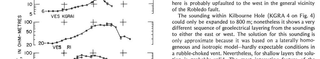
3 New Mexico Geol. Soc. Guidebook, 26th Field Conf., Las Cruces Country, DIRECT-CURRENT SOUNDINGS ON THE LA MESA SURFACE NEAR KILBOURNE AND HUNTS HOLES, NEW MEXICO by DALLAS B. JACKSON and ROBERT J. BISDORF U.S. Geological Survey Denver, Colorado This paper is a resume of a profile of resistivity soundings made on the La Mesa surface in southwestern Dona Ana County, New Mexico, from 3 mi west of Kilbourne Hole to 2 mi northwest of Lanark (Fig. 1). The resistivity profile con- sisted of eight soundings, including one in Kilbourne Hole. A ninth sounding, not shown on the profile, was made in Hunts Hole. The only geoelectrical control available in the study area was from the Texaco S. H. Weaver-Federal 1 well (King and others, 1971) at the east end of the profile. Resistivities for the various geoelectrical units recognized in the Texaco well were used along the line to the west as faithfully as possible, changes in the geoelectrical layer resistivities being made only when demanded by theoretical curve matches to the field sounding data. All the vertical electrical soundings (VES) were made with a collinear Schlumberger array using direct current (Keller and Frischknecht, 1966). The VES curves were interpreted using the U.S.G.S. automatic resistivity interpretation program and operations with Dar Zarrouk curves as described by Zohdy (1974 a, b, and 1975). An example of a set of field data, its computed theoretical curve, and the layered resistivity model for VES 3 is shown in Figure 2. Field data for the remainder of the soundings are shown in Figure 3. The interpretation of the geoelectrical layering along the sounding profile is shown in Figure 4. The Texaco well was used as a base from which soundings along the profile toward the west were interpreted. Figure 5 shows the correlation between the geoelectrical layers interpreted for VES M4 and the deep induction log for the Texaco well. Although no ascending terminal branch was recorded on VES M4, such a branch was seen on every sounding from R5 to R2. It is rea sonable to expect that if VES M4 could have been expanded to larger current electrode spacings, a rising terminal branch would have been recorded. The rising branches on VES 5 through VES 2 evidently reflect the presence of the top of a Tertiary volcanic sequence. By assuming a 30 ohm-m layer (the approximate resistivity recorded on the deep induction log near the top of the volcanic sequence identified on the Texaco well log by King and others, 1971) beneath VES M4 a model was calculated that gave a geoelectrical layering compatible with the electric log and that also fitted the sounding curve. The upper geoelectrical layers that vary from 30 to 230 ohm-m at VES M4 roughly correspond to sedimentary rock above the water table. At depths greater than about 120 m the sedimentary rocks are water saturated and the resistivity decreases accordingly. At depths below 375 m to the top of the Tertiary volcanic rocks the resistivity decreases markedly to about 2.4 ohm-m, although the lithologic log of the Texaco well does not show such an abrupt change in lithology. The most likely explanation for such a resistivity decrease is either an approximate five-fold increase in the pore water salinity or a large increase in the amount of clay and shale in the section that somehow was not recorded in the lithologic log. A third possibility, less likely, is an abrupt increase in water temperature. The 2.4 ohm-m layer is an excellent geoelectric marker and can be traced easily as far west as VES R2 on the east edge of Kilbourne Hole. Between VES M4 and VES R2 the base of the 2.2 to 2.4 ohm-m layer deepens by about 400 m, giving an apparent dip of 1 to 2 degrees west. The lowest unit shown in Figure 4 represents electrical basement.
4

5
New Mexico Geological Society
 New Mexico Geological Society Downloaded from: http://nmgs.nmt.edu/publications/guidebooks/43 Volcanic geology of the Rio Puerco necks R. Bruce Hallett, 1992, pp. 135-144 in: San Juan Basin IV, Lucas,
New Mexico Geological Society
 New Mexico Geological Society Downloaded from: http://nmgs.nmt.edu/publications/guidebooks/34 Recent measurements of crustal deformation related to the Socorro magma body, New Mexico Shawn Larsen and Robert
New Mexico Geological Society
 New Mexico Geological Society Downloaded from: http://nmgs.nmt.edu/publications/guidebooks/29 Laramide thrust faulting, Klondike Hills, southwestern New Mexico LeRoy L. Corbitt, F. L. Nials, and R. J.
New Mexico Geological Society
 New Mexico Geological Society Downloaded from: http://nmgs.nmt.edu/publications/guidebooks/35 Structural anomalies in the Espanola Basin Bruce A. Black, 1984, pp. 59-62 in: Rio Grande Rift (Northern New
New Mexico Geological Society
 New Mexico Geological Society Downloaded from: http://nmgs.nmt.edu/publications/guidebooks/25 Structure of the Guadalupe Box area, Sandoval County, New Mexico Harvey R. DuChene, 1974, pp. 131-135 in: Ghost
New Mexico Geological Society
 New Mexico Geological Society Downloaded from: http://nmgs.nmt.edu/publications/guidebooks/32 Rio Blanco Oil Shale Company Tract C-a, Rio Blanco County, Colorado: Summary of geology and current development
New Mexico Geological Society
 New Mexico Geological Society Downloaded from: http://nmgs.nmt.edu/publications/guidebooks/13 Paleontological reconnaissance of subsurface Pennsylvanian in southern pache and Navajo Counties, rizona Donald
New Mexico Geological Society
 New Mexico Geological Society Downloaded from: http://nmgs.nmt.edu/publications/guidebooks/26 Tertiary floras from the Rio Grande Rift Daniel I. Axelrod, 1975, pp. 85-88 in: Las Cruces Country, Seager,
New Mexico Geological Society
 New Mexico Geological Society Downloaded from: http://nmgs.nmt.edu/publications/guidebooks/26 Tectonic significance of the Pony Hills, Luna County, New Mexico LeRoy L. Corbitt and Fred L. Nials, 1975,
New Mexico Geological Society
 New Mexico Geological Society Downloaded from: http://nmgs.nmt.edu/publications/guidebooks/30 Geochronologic and rare-earth study of the Embudo granite and related rocks Marcia E. Register and D. G. Brookins,
New Mexico Geological Society
 New Mexico Geological Society Downloaded from: http://nmgs.nmt.edu/publications/guidebooks/25 Outline of the igneous geology of the Jemez Mountain volcanic field A. M. Kudo, 1974, pp. 287-289 in: Ghost
New Mexico Geological Society
 New Mexico Geological Society Downloaded from: http://nmgs.nmt.edu/publications/guidebooks/9 Summary of coal resources of the Black Mesa coal field, Arizona R. B. O'Sullivan, 1958, pp. 169-171 in: Black
New Mexico Geological Society
 New Mexico Geological Society Downloaded from: http://nmgs.nmt.edu/publications/guidebooks/34 Magma bodies in the Rio Grande rift in central New Mexico Allan R. Sanford, 1983, pp. 123-125 in: Socorro Region
New Mexico Geological Society
 New Mexico Geological Society Downloaded from: http://nmgs.nmt.edu/publications/guidebooks/19 Vanadium deposits of the Placerville area, San Miguel County, Colorado R. P. Fischer, 1968, pp. 100-103 in:
New Mexico Geological Society
 New Mexico Geological Society Downloaded from: http://nmgs.nmt.edu/publications/guidebooks/19 Pennsylvanian correlations in southwestern Colorado Sherman A. Wengerd and Ernest Szabo, 1968, pp. 159-164
New Mexico Geological Society
 New Mexico Geological Society Downloaded from: http://nmgs.nmt.edu/publications/guidebooks/23 Structural interpretation of the fractures associated with the Bonita Fault D. W. Stearns, 1972, pp. 161-164
New Mexico Geological Society
 New Mexico Geological Society Downloaded from: http://nmgs.nmt.edu/publications/guidebooks/31 Seismicity in the Basin and Range province of Texas and northeastern Chihuahua, Mexico David B. Dumas, 1980,
New Mexico Geological Society
 New Mexico Geological Society Downloaded from: http://nmgs.nmt.edu/publications/guidebooks/27 Structural framework of the southern Raton Basin, New Mexico Lee A. Woodward and D. O. Snyder, 1976, pp. 125-127
New Mexico Geological Society
 New Mexico Geological Society Downloaded from: http://nmgs.nmt.edu/publications/guidebooks/34 Hydrological investigations near Socorro, New Mexico, using electrical resistivity George R. Jiracek, 1983,
New Mexico Geological Society
 New Mexico Geological Society Downloaded from: http://nmgs.nmt.edu/publications/guidebooks/18 Geomorphology and structure in the Grants mineral belt Robert A. Laverty, 1967, pp. 188-194 in: Defiance, Zuni,
New Mexico Geological Society
 New Mexico Geological Society Downloaded from: http://nmgs.nmt.edu/publications/guidebooks/30 Structure and stratigraphy of the Hagan embayment--a new look Bruce A. Black, 1979, pp. 101-105 in: Santa Fe
New Mexico Geological Society
 New Mexico Geological Society Downloaded from: http://nmgs.nmt.edu/publications/guidebooks/27 Depositional environments and trace fossils of the Trinidad Sandstone, southern Raton Basin, New Mexico Charles
Please be sure to save a copy of this activity to your computer!
 Thank you for your purchase Please be sure to save a copy of this activity to your computer! This activity is copyrighted by AIMS Education Foundation. All rights reserved. No part of this work may be
Groundwater Assessment in Apapa Coast-Line Area of Lagos Using Electrical Resistivity Method
 Journal of Emerging Trends in Engineering and Applied Sciences (JETEAS) 2 (4): 673-679 Scholarlink Research Institute Journals, 2011 (ISSN: 2141-7016) jeteas.scholarlinkresearch.org Groundwater Assessment
Geology Stratigraphic Correlations (Lab #4, Winter 2010)
") Name: Answers Reg. lab day: Tu W Th Geology 1023 Stratigraphic Correlations (Lab #4, Winter 2010) Introduction Stratigraphic correlation is the process of comparing rocks at one locality with related rocks
Name: Answers Reg. lab day: Tu W Th Geology 1023 Stratigraphic Correlations (Lab #4, Winter 2010) Introduction Stratigraphic correlation is the process of comparing rocks at one locality with related rocks
New Mexico Geological Society
 New Mexico Geological Society Downloaded from: http://nmgs.nmt.edu/publications/guidebooks/28 Geohydrology of the Westwater Canyon Member, Morrison Formation, of the southern San Juan Basin, New Mexico
A surficial. P^HiHI waste disposal site, Bureau County, Illinois. east of the Sheffield low-level radioactive. electrical resistivity survey
 ISGS CONTRACT/GRANT REPORT 1981-6 WATER RESOURCES DIVISION/USGS P^HiHI 100240 557.09773 IL6cr 1981-6 A surficial electrical resistivity survey east of the Sheffield low-level radioactive waste disposal
Geophysical Study of the Sedimentary Cover in Darb El-Arbeen, South Western Desert, Egypt
 Memoirs of the Faculty of Engineering, Kyushu University, Vol.68, No.1, March 2008 Geophysical Study of the Sedimentary Cover in Darb El-Arbeen, South Western Desert, Egypt by MOHAMED ABDEL ZAHER *, SULTAN
FOREWORD C. E. CHAPIN W. E. ELSTON. Frontispiece: Socorro Peak from campus of New Mexico Institute of Mining and Technology (Photo by H. L.
 .. st ^ :%''L.: FOREWORD This volume has been prepared for the spring meeting of the New Mexico Geological Society, May 17-20, 1978. Previous spring meetings of the Society have generally consisted of
New Mexico Geological Society
 New Mexico Geological Society Downloaded from: http://nmgs.nmt.edu/publications/guidebooks/25 Landslides on "Brazos Pass" Warren Bennett, 1974, pp. 359-363 in: Ghost Ranch, Siemers, C. T.; Woodward, L.
Seismic Reflection Imaging across the Johnson Ranch, Valley County, Idaho
 Seismic Reflection Imaging across the Johnson Ranch, Valley County, Idaho Report Prepared for the Skyline Corporation Lee M. Liberty Center for Geophysical Investigation of the Shallow Subsurface (CGISS)
Structural Geology Lab. The Objectives are to gain experience
 Geology 2 Structural Geology Lab The Objectives are to gain experience 1. Drawing cross sections from information given on geologic maps. 2. Recognizing folds and naming their parts on stereoscopic air
Placer Gold Deposits Of Nevada (Original Geological Survey Bulletins) By Maureen G. Johnson READ ONLINE
 By Maureen G. Johnson READ ONLINE") Placer Gold Deposits Of Nevada (Original Geological Survey Bulletins) By Maureen G. Johnson READ ONLINE Johnson Placer Gold Deposits of Nevada by Maureen G Placer Gold Deposits of Arizona (Original Geological
Placer Gold Deposits Of Nevada (Original Geological Survey Bulletins) By Maureen G. Johnson READ ONLINE Johnson Placer Gold Deposits of Nevada by Maureen G Placer Gold Deposits of Arizona (Original Geological
Morenikeji P. Anjorin, B.Tech. 1 and Martins O. Olorunfemi, Ph.D. 2*
 A Short Note on Comparative Study of Schlumberger and Half Schlumberger Arrays in Vertical Electrical Sounding in a Basement Complex Terrain of Southwest Nigeria. Morenikeji P. Anjorin, B.Tech. 1 and Martins
Analysis of electrical resistivity data for the determination of aquifer depth at Sapele RD in Benin city
 Available online at www.pelagiaresearchlibrary.com Advances in Applied Science Research, 203, 4(6):268-276 ISSN: 0976-860 CODEN (USA): AASRFC Analysis of electrical resistivity data for the determination
GEOL4714 Final Exam Fall 2005, C. H. Jones instructor
 GEOL4714 Final Exam Fall 2005 p. 1 GEOL4714 Final Exam Fall 2005, C. H. Jones instructor Name: Student ID #: Feel free to use the back of the sheets for answers needing more space. (1) (10 pts) For each
NOTICE CONCERNING COPYRIGHT RESTRICTIONS
 NOTICE CONCERNING COPYRIGHT RESTRICTIONS This document may contain copyrighted materials These materials have been made available for use in research, teaching, and private study, but may not be used for
Assessment of Ground Water in a Part of Coastal West Bengal using Geo-Electrical Method
 Vol. 13, No. 2, pp. 203-210 (2013) Journal of Agricultural Physics ISSN 0973-032X http://www.agrophysics.in Research Article Assessment of Ground Water in a Part of Coastal West Bengal using Geo-Electrical
New Mexico Geological Society
 New Mexico Geological Society Downloaded from: http://nmgs.nmt.edu/publications/guidebooks/33 Geochemical studies of discharge water from a uranium acid-leach process Patrick A. Longmire and Douglas G.
Structural Geology Lab. The Objectives are to gain experience
 Geology 2 Structural Geology Lab The Objectives are to gain experience 1. Drawing cross sections from information given on geologic maps. 2. Recognizing folds and naming their parts on stereoscopic air
OTC OTC PP. Abstract
 OTC OTC-19977-PP Using Modern Geophysical Technology to Explore for Bypassed Opportunities in the Gulf of Mexico R.A. Young/eSeis; W.G. Holt, G. Klefstad/ Fairways Offshore Exploration Copyright 2009,
New Mexico Geological Society
 New Mexico Geological Society Downloaded from: http://nmgs.nmt.edu/publications/guidebooks/35 Seismicity of the Rio Grande rift in northern New Mexico, 1973-1983 Daniel J. Cash and Joyce J. Wolff, 1984,
Determining the Relationship between Resistivity, Water and Hydrocarbon Saturation of Rock Formation Using Composite Well Logs
 Determining the Relationship between Resistivity, Water and Hydrocarbon Saturation of Rock Formation Using Composite Well Logs Doi:10.5901/ajis.2013.v2n13p119 Absract Mamudu Afizu Department of Physics,
Geophysical Investigation: A Case Study of Basement Complex, Nigeria
 Geophysical Investigation: A Case Study of Basement Complex, Nigeria Adiela U.P 1, Ayodele Moses Oyewole 2 and Omoirabor Omoleomo 3 1 Department of Petroleum Engineering, Nigerian Agip Oil Company, Port
Geophysical Investigation of the Precambrian Marble Occurrence in Itobe Area, Central Nigeria
 British Journal of Applied Science & Technology 4(13): 1891-1904, 2014 SCIENCEDOMAIN international www.sciencedomain.org Geophysical Investigation of the Precambrian Marble Occurrence in Itobe Area, Central
Geophysics Course Introduction to DC Resistivity
 NORAD supported project in MRRD covering Capacity Building and Institutional Cooperation in the field of Hydrogeology for Faryab Province Afghanistan Geophysics Course Introduction to DC Resistivity By
New Mexico Geological Society
 New Mexico Geological Society Downloaded from: http://nmgs.nmt.edu/publications/guidebooks/63 Upper Cretaceous dinosaur footprints from Grant County, New Mexico Spencer G. Lucas and Charles A. Ferguson,
Application of Transient Electromagnetics for the Investigation of a Geothermal Site in Tanzania
 Application of Transient Electromagnetics for the Investigation of a Geothermal Site in Tanzania Gerlinde Schaumann, Federal Institute for Geosciences and Natural Resources (BGR), Stilleweg 2, 30655 Hannover,
Investigation IV: Seasonal Precipitation and Seasonal Surface Runoff in the US
 Investigation IV: Seasonal Precipitation and Seasonal Surface Runoff in the US Purpose Students will consider the seasonality of precipitation and surface runoff and think about how the time of year can
Electrical Resistivity Survey Forground Water At Eye Zheba Village, Off Bida - Minna Road
 OSR Journal of Applied Geology and Geophysics (OSR-JAGG) e-ssn: 2321 0990, p-ssn: 2321 0982.Volume 3, ssue 2 Ver. (Mar - Apr. 2015), PP 49-53 www.iosrjournals.org Electrical Resistivity Survey Forground
EVALUATION OF GROUNDWATER POTENTIAL USING ELECTRICAL RESISTIVITY METHOD IN OKENUGBO AREA, AGO - IWOYE, SOUTHWESTERN, NIGERIA.
 EVALUATION OF GROUNDWATER POTENTIAL USING ELECTRICAL RESISTIVITY METHOD IN OKENUGBO AREA, AGO - IWOYE, SOUTHWESTERN, NIGERIA. OLADUNJOYE H.T., 1 ODUNAIKE R.K., 1 OGUNSOLA P 1. OLALEYE O.A. 2 1 DEPARTMENT
MRD 228 METADATA. Official Name of the Data Set or Information Holding: Physiography of Southern Ontario
 MRD 228 METADATA GENERAL INFORMATION Official Name of the Data Set or Information Holding: Physiography of Southern Ontario Acronyms are Used to Identify the Data Set or Information Holding: MRD228 Describe
AN INTEGRATED GEOPHYSICAL INVESTIGATION OF A SPRING IN IBUJI, IGBARA-OKE, SOUTHWESTERN NIGERIA.
 Ife Journal of Science vol. 13, no. 1 (2011) AN INTEGRATED GEOPHYSICAL INVESTIGATION OF A SPRING IN IBUJI, IGBARA-OKE, SOUTHWESTERN NIGERIA. 63 Bayode S. * and Akpoarebe O. Department of Applied Geophysics,
fregonruleco. 1 U.S.A. 2
 3 5 fregonruleco. 1 U.S.A. 2 557.09773 IL6cr 1985-1 Qojl ^^\ ISGS CONTRACT/GRANT REPORT 1985-1 GEOPHYSICAL STUDIES AT THE SHEFFIELD LOW-LEVEL RADIOACTIVE WASTE DISPOSAL FACILITY TO EVALUATE POTENTIAL PATHWAYS
PROCEEDINGS, INDONESIAN PETROLEUM ASSOCIATION Thirty-Ninth Annual Convention and Exhibition, May 2015
 IPA15-SG-089 PROCEEDINGS, INDONESIAN PETROLEUM ASSOCIATION Thirty-Ninth Annual Convention and Exhibition, May 2015 STRUCTURAL INTERPRETATION OF TECTONICALLY ASSOCIATED NORMAL AND REVERSE FAULTS OF BUKIT
New Mexico Geological Society
 New Mexico Geological Society Downloaded from: http://nmgs.nmt.edu/publications/guidebooks/16 Geologic structure pattern of Grant County, New Mexico Frederick D. Trauger, 1965, pp. 184-187 in: Southwestern
P.R. SPRING AND HILL CREEK TAR SAND AREAS A RESOURCE ASSESSMENT (IN PROGRESS)
") P.R. SPRING AND HILL CREEK TAR SAND AREAS A RESOURCE ASSESSMENT (IN PROGRESS) presented by WALLY GWYNN - Utah Geological Survey at the Western U.S. Oil Sands Technology Transfer Meeting February 22, 2008
P.R. SPRING AND HILL CREEK TAR SAND AREAS A RESOURCE ASSESSMENT (IN PROGRESS) presented by WALLY GWYNN - Utah Geological Survey at the Western U.S. Oil Sands Technology Transfer Meeting February 22, 2008
A Case Study of High-Resolution Gravity and Wenner-Schlumberger Resistivity for Geotechnical Engineering: An Example from North Jordan
 Research Journal of Applied Sciences, Engineering and Technology 5(4): 1377-1382-, 2013 ISSN: 2040-7459; e-issn: 2040-7467 Maxwell Scientific Organization, 2013 Submitted: July 09, 2012 Accepted: August
New Mexico Geological Society
 New Mexico Geological Society Downloaded from: http://nmgs.nmt.edu/publications/guidebooks/27 Tonstein occurrences in the Raton coal field, Colfax County, New Mexico Bruce F. Bohor and C. L. Pillmore,
Vertical Electrical Sounding Survey for Groundwater Exploration in Parts of Anyigba and its Environs, in the Anambra Basin of Nigeria
 British Journal of Applied Science & Technology 4(): 978-988, 204 SCIENCEDOMAIN international www.sciencedomain.org Vertical Electrical Sounding Survey for Groundwater Exploration in Parts of and its Environs,
New Mexico Geological Society
 New Mexico Geological Society Downloaded from: http://nmgs.nmt.edu/publications/guidebooks/19 Multiple intrusions in the San Miguel Mountains, Colorado Calvin S. Bromfield and Alfred L. Bush, 1968, pp.
Hydrogeophysical investigation in selected parts of Irepodun/Ifelodun local government area of Ekiti State, Southwestern Nigeria
 Vol. 5(7), pp. 200-207, July, 2013 DOI: 10.5897/JGMR2013.0183 ISSN 2006 9766 2013 Academic Journals http://www.academicjournals.org/jgmr Journal of Geology and Mining Research Full Length Research Paper
Earth Science Section 12 Volcano Workbook Answers File Type
 Earth Science Section 12 Volcano Workbook Answers File Type We have made it easy for you to find a PDF Ebooks without any digging. And by having access to our ebooks online or by storing it on your computer,
Geophysical Investigation of Ground Water Using Vertical Electrical Sounding and Seismic Refraction Methods
 International Journal of Petroleum and Petrochemical Engineering (IJPPE) Volume 2, Issue 1, 2016, PP 6-11 ISSN 2454-7980 (Online) www.arcjournals.org Geophysical Investigation of Ground Water Using Vertical
New Mexico Geological Society
 New Mexico Geological Society Downloaded from: http://nmgs.nmt.edu/publications/guidebooks/26 Geology of the central Organ Mountains Dona Aña County, New Mexico Thomas G. Glover, 1975, pp. 157-161 in:
Robert S. Sawin Stratigraphic Research Section Kansas Geological Survey. Open-File Report
 Copies of Archived Correspondence Pertinent to the Decision to Classify the Exposure at Point of Rocks, Morton County, Kansas, as Jurassic by the Kansas Geological Survey in 1967 Robert S. Sawin Stratigraphic
Last Updated HYDROLOGIC ATLAS OF THE BLACK HILLS, PENNINGTON COUNTY, SOUTH DAKOTA
 Last Updated 10-29-2015 HYDROLOGIC ATLAS OF THE BLACK HILLS, PENNINGTON COUNTY, SOUTH DAKOTA INTRODUCTION The following is a brief outline of ground water characteristics in Pennington County, South Dakota.
Scholars Research Library. Geophysical investigation of effects of topographic complexities on groundwater potential in Ibusa, Delta State Nigeria
 Available online at www.scholarsresearchlibrary.com Scholars Research Library Archives of Physics Research, 010, 1 (3):6-71 (http://scholarsresearchlibrary.com/archive.html) ISSN 0976-0970 CODEN (USA):
Geophysical Investigation of a Suspected Foundation Failure at Ogbomoso, Southwestern, Nigeria.
 Geophysical Investigation of a Suspected Foundation Failure at Ogbomoso, Southwestern, Nigeria. Enoch E. Sangodiji, M.Sc. and Martins O. Olorunfemi, Ph.D. Department of Applied Geophysics, Federal University
Vertical electrical sounding (VES) for subsurface geophysical investigation in Kanigiri area, Prakasam district, Andhra Pradesh, India
 for subsurface geophysical investigation in Kanigiri area, Prakasam district, Andhra Pradesh, India") Available online at www.pelagiaresearchlibrary.com Advances in Applied Science Research, 2014, 5(5):82-86 ISSN: 0976-8610 CODEN (USA): AASRFC Vertical electrical sounding (VES) for subsurface geophysical
Available online at www.pelagiaresearchlibrary.com Advances in Applied Science Research, 2014, 5(5):82-86 ISSN: 0976-8610 CODEN (USA): AASRFC Vertical electrical sounding (VES) for subsurface geophysical
New Mexico Geological Society
 New Mexico Geological Society Downloaded from: http://nmgs.nmt.edu/publications/guidebooks/24 Structural framework and tectonic evolution of the Four Corners region of the Colorado Plateau Lee A. Woodward,
GM 1.4. SEG/Houston 2005 Annual Meeting 639
 storage recovery project in Leyden, Colorado Kristofer Davis *, Yaoguo Li, Michael Batzle, and Bob Raynolds** Center for Gravity, Electrical, and Magnetic Studies, Department of Geophysics, Colorado School
New Mexico Geological Society
 New Mexico Geological Society Downloaded from: http://nmgs.nmt.edu/publications/guidebooks/55 Field geophysical training of astronauts in the Taos region P. W. Dickerson, 2004, pp. 278-281 in: Geology
New Mexico Geological Society
 New Mexico Geological Society Downloaded from: http://nmgs.nmt.edu/publications/guidebooks/29 Late Cenozoic vertebrate faunas, southeastern Arizona Everett Lindsay, 1978, pp. 269-275 in: Land of Cochise
DETECTION OF GROUNDWATER POLLUTION USING RESISTIVITY IMAGING AT SERI PETALING LANDFILL, MALAYSIA
 JOURNAL OF ENVIRONMENTAL HYDROLOGY The Electronic Journal of the International Association for Environmental Hydrology On the World Wide Web at http://www.hydroweb.com VOLUME 8 2000 DETECTION OF GROUNDWATER
ELECTRICAL RESISTIVITY SURVEY OF INTREPID POTASH INJECTION WELL SITE: EDDY COUNTY, NEW MEXICO
 NCKRI REPORT OF INVESTIGATION 3 ELECTRICAL RESISTIVITY SURVEY OF INTREPID POTASH INJECTION WELL SITE: EDDY COUNTY, NEW MEXICO www.nckri.org NATIONAL CAVE AND KARST RESEARCH INSTITUTE REPORT OF INVESTIGATION
A Joint European GIS Under Construction: The 1:5 Million International Geological Map of Europe and Adjacent Areas (IGME 5000)
") Abstract 2001 Annual Conference of the International Association for Mathematical Geology Technical Program - Session I (Poster) Building National and Regional Geologic Map Databases A Joint European GIS
Abstract 2001 Annual Conference of the International Association for Mathematical Geology Technical Program - Session I (Poster) Building National and Regional Geologic Map Databases A Joint European GIS
THE UNIVERSITY OF TRINIDAD & TOBAGO
 THE UNIVERSITY OF TRINIDAD & TOBAGO B. A. SC. PETROLEUM ENGINEERING ALTERNATE 2012 FINAL EXAMINATIONS Course Code and Title: Programme: DATE: DURATION: FMEV 2002 - BASIC WELL LOGGING BASc B.A.SC. Petroleum
New Mexico Geological Society
 New Mexico Geological Society Downloaded from: http://nmgs.nmt.edu/publications/guidebooks/19 Joint analysis applied to structures of the Silverton volcanic center Schwarz, Frederick P., Jr., 1968, pp.
Activity Plotting Earthquake Epicenters an activity for seismic discovery
 Note: this is not an activity from the TOTLE workshop, but is a good prerequisite to the triangulation activity that follows. Activity Plotting Earthquake Epicenters an activity for seismic discovery x
Vertical Electrical Sounding (Ves) For The Determination Of Under Ground Resistivity In Part Of Nigeria Wilberforce Island,Amassoma, Bayelsa State
 For The Determination Of Under Ground Resistivity In Part Of Nigeria Wilberforce Island,Amassoma, Bayelsa State") IOSR Journal of Research & Method in Education (IOSR-JRME) e-issn: 2320 7388,p-ISSN: 2320 737X Volume 7, Issue 2 Ver. III (Mar. - Apr. 2017), PP 53-61 www.iosrjournals.org Vertical Electrical Sounding
IOSR Journal of Research & Method in Education (IOSR-JRME) e-issn: 2320 7388,p-ISSN: 2320 737X Volume 7, Issue 2 Ver. III (Mar. - Apr. 2017), PP 53-61 www.iosrjournals.org Vertical Electrical Sounding
Geophysical Investigation of Foundation Condition of A Site in Ikere- Ekiti, Ekiti State, South-Western Nigeria
 Australian Journal of Basic and Applied Sciences, 5(9): 1852-1857, 2011 ISSN 1991-8178 Geophysical Investigation of Foundation Condition of A Site in Ikere- Ekiti, Ekiti State, South-Western Nigeria 1
First Technical Report Geophysical experiments near Kajiado town
 First Technical Report Geophysical experiments near Kajiado town Synthesis Report of First case study within the ISGEAG VIA Water project By: Michel Groen *), Harry Rolf **), and Ammon Muiti ***) *) Acacia
A Preliminary Geophysical Reconnaissance Mapping of Emirau Ground Water Resource, Emirau Island, New Ireland Province, PNG
 A Preliminary Geophysical Reconnaissance Mapping of Emirau Ground Water Resource, Emirau Island, New Ireland Province, PNG Geological Survey Division of Mineral Resources Authority (MRA) Papua New Guinea
INTEGRATION OF BOREHOLE INFORMATION AND RESISTIVITY DATA FOR AQUIFER VULNERABILITY
 INTEGRATION OF BOREHOLE INFORMATION AND RESISTIVITY DATA FOR AQUIFER VULNERABILITY ANDERS V. CHRISTIANSEN 1, ESBEN AUKEN 1 AND KURT SØRENSEN 1 1 HydroGeophysics Group, Aarhus University, Finlandsgade 8,
Formation Evaluation: Logs and cores
 These powerpoint files were produced for the Earth History class at the Free University Berlin, Department of Geological Sciences The copyright for texts, graphical elements, and images lies with C. Heubeck,
KARST MAPPING WITH GEOPHYSICS AT MYSTERY CAVE STATE PARK, MINNESOTA
 KARST MAPPING WITH GEOPHYSICS AT MYSTERY CAVE STATE PARK, MINNESOTA By Todd A. Petersen and James A. Berg Geophysics Program Ground Water and Climatology Section DNR Waters June 2001 1.0 Summary A new
Ground-Water Exploration in the Worthington Area of Nobles County: Summary of Seismic Data and Recent Test Drilling Results
 Ground-Water Exploration in the Worthington Area of Nobles County: Summary of Seismic Data and Recent Test Drilling Results Jim Berg and Todd Petersen Geophysicists, DNR Waters January 2000 Table of Contents
REPEATABILITY OBSERVATIONS FROM A 2D TIME-LAPSE SEISMIC SURVEY. Abstract
 REPEATABILITY OBSERVATIONS FROM A 2D TIME-LAPSE SEISMIC SURVEY Downloaded 07/03/14 to 129.237.143.21. Redistribution subject to SEG license or copyright; see Terms of Use at http://library.seg.org/ Shelby
Assignment 2: Unit Plan 5 days
 GEOS898 UNL History on the Rocks Assignment 2: Unit Plan 5 days Mark Shearer Lincoln Southwest, Lincoln, NE 2008 1 Sedimentary Rocks Grade level: 9 th -10 th Purpose: This unit lesson will give students
POTASH DRAGON CHILE GEOPHYSICAL SURVEY TRANSIENT ELECTROMAGNETIC (TEM) METHOD. LLAMARA and SOLIDA PROJECTS SALAR DE LLAMARA, IQUIQUE, REGION I, CHILE
 METHOD. LLAMARA and SOLIDA PROJECTS SALAR DE LLAMARA, IQUIQUE, REGION I, CHILE") POTASH DRAGON CHILE GEOPHYSICAL SURVEY TRANSIENT ELECTROMAGNETIC (TEM) METHOD LLAMARA and SOLIDA PROJECTS SALAR DE LLAMARA, IQUIQUE, REGION I, CHILE OCTOBER 2012 CONTENT Page I INTRODUCTION 1 II FIELD
POTASH DRAGON CHILE GEOPHYSICAL SURVEY TRANSIENT ELECTROMAGNETIC (TEM) METHOD LLAMARA and SOLIDA PROJECTS SALAR DE LLAMARA, IQUIQUE, REGION I, CHILE OCTOBER 2012 CONTENT Page I INTRODUCTION 1 II FIELD
GEOL 220A Geologic Field Experiences: West Virginia Spring Term, 2008
 GEOL 220A Geologic Field Experiences: West Virginia Spring Term, 2008 Dr. Fred Soster Office: 216 Julian S&M e-mail: fsoster@depauw.edu Phone: 658-4670 Meeting Times: 2:15-3:15 p.m., Monday & Wednesday;
RESISTIVITY IMAGING IN EASTERN NEVADA USING THE AUDIOMAGNETOTELLURIC METHOD FOR HYDROGEOLOGIC FRAMEWORK STUDIES. Abstract.
 RESISTIVITY IMAGING IN EASTERN NEVADA USING THE AUDIOMAGNETOTELLURIC METHOD FOR HYDROGEOLOGIC FRAMEWORK STUDIES Darcy K. McPhee, U.S. Geological Survey, Menlo Park, CA Louise Pellerin, Green Engineering,
Case Study: University of Connecticut (UConn) Landfill
 Landfill") Case Study: University of Connecticut (UConn) Landfill Problem Statement:» Locate disposal trenches» Identify geologic features and distinguish them from leachate and locate preferential pathways in fractured
Case Study: University of Connecticut (UConn) Landfill Problem Statement:» Locate disposal trenches» Identify geologic features and distinguish them from leachate and locate preferential pathways in fractured
PROBLEM SET #X. 2) Draw a cross section from A-A using the topographic profile provided on page 3.
 Draw a cross section from A-A using the topographic profile provided on page 3.") PROBLEM SET #X PART A: The geologic map on page 3 is from an area consisting of faulted Miocene sedimentary rocks. There are two major faults exposed here: the Rattlesnake fault and the Jackrabbit fault.
PROBLEM SET #X PART A: The geologic map on page 3 is from an area consisting of faulted Miocene sedimentary rocks. There are two major faults exposed here: the Rattlesnake fault and the Jackrabbit fault.
Inductive source induced polarization David Marchant, Eldad Haber and Douglas W. Oldenburg, University of British Columbia
 David Marchant, Eldad Haber and Douglas W. Oldenburg, University of British Columbia Downloaded /9/3 to 37.8.7.. Redistribution subject to SEG license or copyright; see Terms of Use at http://library.seg.org/
Activity - Using GPS Data and Geologic Markers to Track Plate Motion
 Name: Date: Hour: Activity - Using GPS Data and Geologic Markers to Track Plate Motion Section Points Received Points Possible Part A Analysis 4.5 Part B Analysis 11.5 Total 16 Introduction: GPS satellites
1-D Electrical Resistivity Survey For Groundwater In Ketu-Adie Owe, Ogun State, Nigeria.
 IOSR Journal of Applied Geology and Geophysics (IOSR-JAGG) e-issn: 2321 0990, p-issn: 2321 0982.Volume 3, Issue 5 Ver. I (Sep. - Oct. 2015), PP 75-82 www.iosrjournals.org 1-D Electrical Resistivity Survey
GY 402: Sedimentary Petrology
 UNIVERSITY OF SOUTH ALABAMA GY 402: Sedimentary Petrology Lecture 27: Introduction to Wireline Log Interpretations Instructor: Dr. Douglas W. Haywick Last Time Carbonate Diagenesis Diagenesis 0.5 mm PPL
GLG 471; MICHIGAN STATE UNIVERSITY INSTRUCTOR R.L. VAN DAM PROJECT: ELECTRICAL RESISTIVITY
 GLG 471; MICHIGAN STATE UNIVERSITY INSTRUCTOR R.L. VAN DAM PROJECT: ELECTRICAL RESISTIVITY General information: This is a group (2-3 students) project requiring lab-, computer-, and fieldwork. Work will