MAPPING AND RESERVOIR CHARACTERIZATION OF GEOLOGIC INTERVALS FOR NGL STORAGE APPLICATIONS
|
|
|
- Irma Sharp
- 5 years ago
- Views:
Transcription
1 MAPPING AND RESERVOIR CHARACTERIZATION OF GEOLOGIC INTERVALS FOR NGL STORAGE APPLICATIONS Robin V. Anthony 1, Doug Patchen 2, Jessica Moore 3, Michael Solis 4 1 PA DCNR, Bureau of Topographic & Geologic Survey 2 Appalachian Oil and Natural Gas Research Consortium, West Virginia University 3 West Virginia Geological and Economic Survey 4 Ohio Geologic Survey, Ohio Department of Natural Resources 1
2 2 BACKGROUND Marcellus and Utica Shale Natural Gas Liquids (NGL s) produced in the tri-state area of OH, PA and WV NGL s can support a global petrochemical industry Strategic location to plastics manufacturing centers Regional cooperation agreement signed in 2015 Subsurface storage will be a necessary component Appalachian Oil & Natural Gas Research Consortium formed to evaluate subsurface storage potential

3 3 AREA OF INTEREST Correlate stratigraphy Map thickness & structure Characterize the reservoir Development and application of rating and ranking criteria
4 4 THREE OPTIONS FOR NGL STORAGE Mined-rock caverns (carbonate rock) Solution-mined caverns (bedded salt) Depleted gas fields (siliciclastic units)
5 5 GEOLOGIC INTERVALS Mined-rock caverns Greenbrier Limestone ( 40 ft thick; 1, ft deep) Salt caverns Salina Group salts ( 100 ft thick) Depleted gas reservoirs or storage fields Keener to Berea sandstones Upper Devonian sandstones (Venango, Bradford, Elk) Oriskany Sandstone Newburg sandstone Clinton/Medina Group Rose Run-Gatesburg sandstones
6 6 GEOLOGIC INTERVALS Mined-rock caverns Greenbrier Limestone ( 40 ft thick; 1, ft deep) Salt caverns Salina Group salts ( 100 ft thick) Depleted gas reservoirs or storage fields Keener to Berea sandstones Upper Devonian sandstones (Venango, Bradford, Elk) Oriskany Sandstone Newburg sandstone Clinton/Medina Group Rose Run-Gatesburg sandstones
7 7 GEOLOGIC INTERVALS Mined-rock caverns Greenbrier Limestone ( 40 ft thick; 1, ft deep) Salt caverns Salina Group salts ( 100 ft thick) Depleted gas reservoirs or storage fields Keener to Berea sandstones Upper Devonian sandstones (Venango, Bradford, Elk) Oriskany Sandstone Newburg sandstone Clinton/Medina Group Rose Run-Gatesburg sandstones
8 8 GEOLOGIC INTERVALS Mined-rock caverns Greenbrier Limestone ( 40 ft thick; 1, ft deep) Salt caverns Salina Group salts ( 100 ft thick) Depleted gas reservoirs or storage fields Keener to Berea sandstones Upper Devonian sandstones (Venango, Bradford, Elk) Oriskany Sandstone Newburg sandstone Clinton/Medina Group Rose Run-Gatesburg sandstones
9 9 GEOLOGIC INTERVALS Mined-rock caverns Greenbrier Limestone ( 40 ft thick; 1, ft deep) Salt caverns Salina Group salts ( 100 ft thick) Depleted gas reservoirs or storage fields Keener to Berea sandstones Upper Devonian sandstones (Venango, Bradford, Elk) Oriskany Sandstone Newburg sandstone Clinton/Medina Group Rose Run-Gatesburg sandstones
10 RESERVOIR CHARACTERIZATION Unique characterization each type of storage container Depth structure maps Thickness isopach maps Extent facies evaluation Preliminary assessment Environments of deposition, post-depositional processes 10
11 420 Ma Late Silurian 11


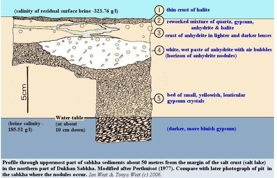
12 Modern Analog: Persian Gulf Sabkha 12


13 The Salina is a bedded salt Core Samples a: Coarse halite crystals with evenly disseminated black anhydrite pieces that give the sample a dark gray color; b: post-lithification fracture includes some salt crystals along the fracture zone; c: brown-gray calcareous shale, thinly laminated, sometimes wavy, partially replaced by salt & pepper carbonate(?)-anhydrite mixture. The shale is interbedded with the carbonate-anhydrite beds. Geophysical Logs Well penetrating the F4 Salt, where lithologies tied into the geophysical log identify zones of anhydrite and dolomite.

14 14 SOLUTION-MINED CAVERNS SALINA SALT Cavern size limited by salt thickness Salt itself forms sealing mechanism for this type of container Need thick intervals of pure salt Need large area to create cavern with buffer zone between cavern and edge of salt Thickness, purity and extent are key factors
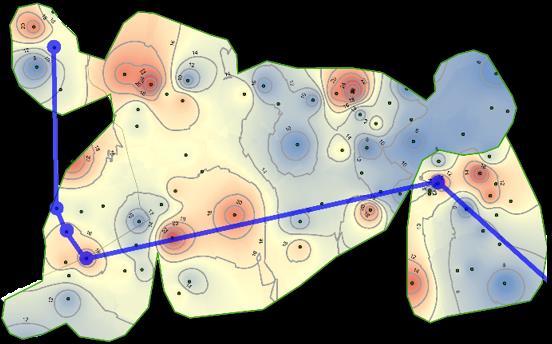
15 SALINA F4 SALT THICKNESS Only Salina salt deposit likely to occur in thicknesses 100 ft. Four areas with net thickness 100 ft.
16 SALINA F4 SALT THICKNESS Only Salina salt deposit likely to occur in thicknesses 100 ft. Four areas with net thickness 100 ft.

17 SALINA F4 SALT THICKNESS Only Salina salt deposit likely to occur in thicknesses 100 ft. Four areas with net thickness 100 ft.
18 SALINA F4 SALT DEPTH Below deepest occurrence of fresh drinking water Few gas wells penetrate salt, so limits vertical migration routes Increase in salt plasticity limits lower cavern depth to <7,000 Area Average Depth (ft) 5,300 6,200 6,650 6,600 Depths to top of F4 Salt relative to Mean Sea Level (MSL) range from -3,700 to -6,000 feet

19 19 SW-NE CROSS SECTION ALONG STRIKE F4 Salt Salt Interbedded dolomite and anhydrite


20 Cross Section AREA 1 F4 Salt Salt Interbedded dolomite and anhydrite Isopach


21 Cross Section AREA 3 F4 Salt Salt Interbedded dolomite and anhydrite Isopach
22 SALINA SALT CAVERNS Mapped net thickness of upper F4 salt (conservative approach) Identified four areas where upper F4 salt >100 ft Salt thickness changes abruptly east and west of the main trend Anhydrite and dolomite increases outside the 100 ft. footprint foot lower salt present below the persistent dolomite anhydrite layer Important to leave buffer zone between caverns and edge of salt basin Pressure, temperature, and cavern shape affect cavern stability 22

23 420 Ma Late Silurian 23
24 NEWBURG Modern Analog: U.S. East Coast (Massachusetts) Coastal Sand Bodies 24
 Coastal")

25 NEWBURG Modern Analog: U.S. East Coast (Massachusetts) Coastal Sand Bodies 25

26 26 NEWBURG: example of depleted gas fields in a sandstone reservoir Porosity / permeability Geophysical logs


27 27 NEWBURG: example of depleted gas fields in a sandstone reservoir Porosity / permeability Thin-section analyses
28 28 NEWBURG: example of depleted gas fields in a sandstone reservoir Thickness (gross isopach map) Areal extent (updip dry holes & wells with salt water downdip delineate container extents) Close to pipeline infrastructure Seals (upper, lower and lateral)
 Close to pipeline infrastructure Seals (upper, lower and")
29 29 NEWBURG: example of depleted gas fields in a sandstone reservoir Thickness (gross isopach map) Areal extent (updip dry holes & wells with salt water downdip delineate container extents) Close to pipeline infrastructure Seals (upper, lower and lateral)
30 30 NEWBURG: example of depleted gas fields in a sandstone reservoir Thickness (gross isopach map) Areal extent (updip dry holes & wells with salt water downdip delineate container extents) Close to pipeline infrastructure Seals (upper, lower and lateral)
31 31 NEWBURG: example of depleted gas fields in a sandstone reservoir Thickness (gross isopach map) Areal extent (updip dry holes & wells with salt water downdip delineate container extents) Close to pipeline infrastructure Seals (upper, lower and lateral)


32 NEWBURG: North Ripley Field W-E Cross-Section Newburg Sandstone 32


33 33 NEWBURG: Net Thickness NW-SE Cross-Section Rocky Fork and Cooper Creek Newburg Sandstone
34 NEWBURG: Depleted Sandstone Reservoirs Field Average producing depth (ft) Average pay thickness (ft)* Pressure (psi) Porosity (%) Permeability (md)* Initial pressure (psi) Trap type North Ripley 5, , ,329 Stratigraphic/ Structural Rocky Fork 5, , ,435 Stratigraphic/ Structural Cooper Creek 5, , ,491 Stratigraphic/ structural Kanawha Forest 5, , ,329 Structural *from Patchen (1996) Good peak storage: High porosity and permeability in thin sandstone reservoir yields small container with high deliverability Updip dry holes (sand pinchout) & wells with salt water downdip structurally delineate lateral container extents Evaporites and carbonates make good vertical seals Close to pipeline infrastructure 34

35 325 Ma Late Mississippian 35


36 Modern Analog: Bahama Banks Carbonate Platform Wynn,
.")
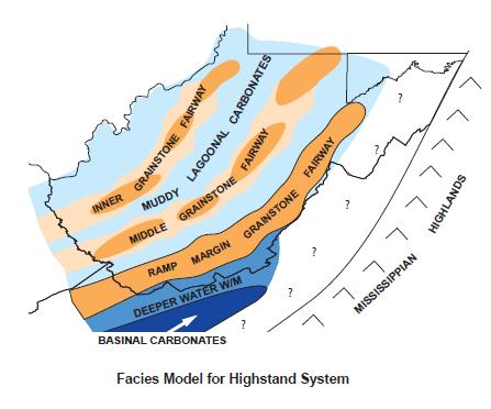
37 37 GREENBRIER LIMESTONE (MINED-ROCK CAVERNS) Characterize facies using geophysical logs (RHOB, DPHI, PE) and drillers descriptions Carbonate ramp environment of deposition Schematic illustration of Mississippian facies distribution of the Appalachian basin (Wynn, 2003). The main facies types within the AOI were deposited in inner- to mid-ramp settings.
 Prepare regional structure")

38 38 GREENBRIER LIMESTONE (MINED-ROCK CAVERNS) Prepare regional structure and isopach contour maps Optimum net thicknesses 40 ft Optimum depths 1,800 2,000 ft
39 39 GREENBRIER LIMESTONE (MINED-ROCK CAVERNS) Prepare regional structure and isopach contour maps Optimum net thicknesses 40 ft Optimum depths 1,800 2,000 ft

40 40 Wynn, 2003 Wynn, 2003
41 GREENBRIER MINED-ROCK CAVERNS Identified three main facies; mapped net thickness of each Upper grainstone (top seal) Lime mudstone (mine) Lower grainstone (bottom seal) 41
42 42 GREENBRIER LIMESTONE THREE FACIES Appalachian Storage Hub (ASH) Study Appalachian Storage Hub (ASH) Study Appalachian Storage Hub (ASH) Study Figure 7. Net thickness map of the Greenbrier lime mudstone facies package.
43 43 GREENBRIER LIMESTONE THREE FACIES Appalachian Storage Hub (ASH) Study Appalachian Storage Hub (ASH) Study Appalachian Storage Hub (ASH) Study Figure 7. Net thickness map of the Greenbrier lime mudstone facies package.

44 Trap integrities of Mined Rock Fields Grainstone facies Lime mudstone facies Good Trap No top Trap Good Trap No bottom Trap Okay Trap No Trap
45 45 MINED-ROCK CAVERNS: GREENBRIER LIMESTONE Not all limestones are the same They differ in grain size, pore space, etc. due to variations in where and how they were deposited Our goal was to find the best type of limestone for storage lithology is important! A mined-rock cavern needs a good seal, so overlying/underlying unit properties are also important
46 46 SUMMARY - POINTS TO CONSIDER Examined three categories of storage options, mined caverns, solution caverns, depleted siliclastic reservoirs Storage capacity and deliverability will ultimately depend on the NGL product(s) Storage capacity and deliverability may require more than one facility and/or more than one geologic container per facility Optimal reservoir types may (or may not) be co-located above or below one another

47 47 CORRELATION DIAGRAM AREA OF INTEREST


48 48 CORRELATION DIAGRAM AREA OF INTEREST

49 49 CORRELATION DIAGRAM AREA OF INTEREST


50 50 ACKNOWLEDGEMENTS AONGRC Douglas Patchen, Jessica Moore, Philip Dinterman, Mohammad Fakhari, Michael Solis, Gary Daft, Kristin Carter, Katherine Schmid, Brian Dunst, Antonette Markowski and Stephen Shank Benedum Foundation Industry Partners AEP, Antero Resources, Blue Racer, Charleston Area Alliance, Chevron, Dominion, EQT, First Energy/Team NEO, Mountaineer NGL Storage LLC, Noble Energy, Southwestern Energy, XTO Energy and the West Virginia Oil & Natural Gas Association West Virginia University WVU Foundation, WVU Research Corporation, National Research Center for Coal and Energy and WVU Corporate Relations Office Advisory Group THANK YOU! Project website available at Robin Anthony Geoscientist Pennsylvania Geological Survey (Pittsburgh, PA)
GEOLOGIC FINDINGS OF THE BENEDUM FOUNDATION S APPALACHIAN STORAGE HUB STUDY
 1 GEOLOGIC FINDINGS OF THE BENEDUM FOUNDATION S APPALACHIAN STORAGE HUB STUDY Kristin M. Carter, P.G., C.P.G. Assistant State Geologist Pennsylvania Geological Survey (Pittsburgh, PA) krcarter@pa.gov ACKNOWLEDGEMENTS
Dr. Douglas Patchen WVU Energy Institute s NRCCE Director, Appalachian Region for PTTC PSU Extension Webinar January 18, 2018
 GEOLOGIC OPTIONS FOR SUBSURFACE STORAGE OF UTICA MARCELLUS NGLS Dr. Douglas Patchen WVU Energy Institute s NRCCE Director, Appalachian Region for PTTC PSU Extension Webinar January 18, 2018 DISTRIBUTION
Evaluating Suitability of Appalachian Basin Reservoirs for NGLs Storage Jessica Moore, West Virginia Geological & Economic Survey
 1 THE APPALACHIAN STORAGE HUB STUDY: Evaluating Suitability of Appalachian Basin Reservoirs for NGLs Storage Jessica Moore, West Virginia Geological & Economic Survey 2 ASH STUDY OUR GOAL Complete a geologic
APPALACHIAN STORAGE HUB (ASH) PROJECT. Semi-Annual Meeting March 14, 2017 WVU Erickson Alumni Center
 PROJECT. Semi-Annual Meeting March 14, 2017 WVU Erickson Alumni Center") APPALACHIAN STORAGE HUB (ASH) PROJECT Semi-Annual Meeting March 14, 2017 WVU Erickson Alumni Center STRATEGY 2: STRATIGRAPHIC CORRELATION Kyle Metz Energy Resources Group, Ohio Department of Natural Resources
APPALACHIAN STORAGE HUB (ASH) PROJECT Semi-Annual Meeting March 14, 2017 WVU Erickson Alumni Center STRATEGY 2: STRATIGRAPHIC CORRELATION Kyle Metz Energy Resources Group, Ohio Department of Natural Resources
A GEOLOGIC STUDY TO DETERMINE THE POTENTIAL TO CREATE AN APPALACHIAN STORAGE HUB FOR NATURAL GAS LIQUIDS FINAL REPORT
 A GEOLOGIC STUDY TO DETERMINE THE POTENTIAL TO CREATE AN APPALACHIAN STORAGE HUB FOR NATURAL GAS LIQUIDS FINAL REPORT Project Start Date: August 1, 2016 Project End Date: July 31, 2017 APPALACHIAN OIL
APPALACHIAN STORAGE HUB (ASH) FOR LIQUID ETHANE. QUARTERLY REPORT August 2016 October Submitted By
 FOR LIQUID ETHANE. QUARTERLY REPORT August 2016 October Submitted By") APPALACHIAN STORAGE HUB (ASH) FOR LIQUID ETHANE QUARTERLY REPORT August 2016 October 2016 Submitted By APPALACHIAN OIL & NATURAL GAS RESEARCH CONSORTIUM National Research Center for Coal & Energy Ohio
APPALACHIAN STORAGE HUB (ASH) FOR LIQUID ETHANE QUARTERLY REPORT August 2016 October 2016 Submitted By APPALACHIAN OIL & NATURAL GAS RESEARCH CONSORTIUM National Research Center for Coal & Energy Ohio
APPALACHIAN STORAGE HUB (ASH) FOR LIQUID ETHANE. QUARTERLY REPORT November 2016 January Submitted By
 FOR LIQUID ETHANE. QUARTERLY REPORT November 2016 January Submitted By") APPALACHIAN STORAGE HUB (ASH) FOR LIQUID ETHANE QUARTERLY REPORT November 2016 January 2017 Submitted By APPALACHIAN OIL & NATURAL GAS RESEARCH CONSORTIUM National Research Center for Coal & Energy Ohio
APPALACHIAN STORAGE HUB (ASH) FOR LIQUID ETHANE QUARTERLY REPORT November 2016 January 2017 Submitted By APPALACHIAN OIL & NATURAL GAS RESEARCH CONSORTIUM National Research Center for Coal & Energy Ohio
MIDDLE DEVONIAN PLAY MICHIGAN BASIN OF ONTARIO. Duncan Hamilton
 MIDDLE DEVONIAN PLAY MICHIGAN BASIN OF ONTARIO Duncan Hamilton 1 Middle Devonian Pools of the Michigan Basin 375+ Million Barrels Michigan 45+ million Barrels Ontario 2 Outline of Presentation History
Mapping and Reservoir Characterization of Geologic Intervals for NGL Storage Applications*
 Mapping and Reservoir Characterization of Geologic Intervals for NGL Storage Applications* Kristin Carter 1, Douglas Patchen 2, Jessica Moore 3, Mohammad Fakhari 4, Gary Daft 3, Phillip Dinterman 3, Michael
Fusselman/Devonian Study. of the Midland Basin, Texas
 Fusselman/Devonian Study of the Midland Basin, Texas Fusselman-Devonian Study of the Midland Basin, Texas Overview The Fusselman-Devonian study of the Midland Basin is designed to enhance both exploration
Relationships of the Ordovician. Appalachian Basin. June 21, 2011
 Regional Stratigraphic and Facies Relationships of the Ordovician Utica/Point i t Pleasant Interval in the Appalachian Basin June 21, 2011 Ron Riley and Mark Baranoski Stratigraphic Correlation Chart Modified
Sequence Stratigraphy of the Upper Cretaceous Niobrara Formation, A Bench, Wattenberg Field, Denver Julesburg Basin, Colorado*
 Sequence Stratigraphy of the Upper Cretaceous Niobrara Formation, A Bench, Wattenberg Field, Denver Julesburg Basin, Colorado* Lisa E. Remington LaChance 1 and Mark C. Robinson 1 Search and Discovery Article
OVERVIEW OF THE ROGERSVILLE SHALE IN WEST VIRGINIA. Philip Dinterman West Virginia Geological & Economic Survey May 11, 2017
 OVERVIEW OF THE ROGERSVILLE SHALE IN WEST VIRGINIA Philip Dinterman West Virginia Geological & Economic Survey May 11, 2017 ACKNOWLEDGEMENT Dave Harris, John Hickman, Kentucky Geological Survey DATA NOTE
Sedimentology and Stratigraphy of Lower Smackover Tight Oil Carbonates: Key to Predictive Understanding of Reservoir Quality and Distribution
 Integrated Reservoir Solutions Sedimentology and Stratigraphy of Lower Smackover Tight Oil Carbonates: Key to Predictive Understanding of Reservoir Quality and Distribution Roger J. Barnaby Presented at
Tim Carr - West Virginia University
 Tim Carr - West Virginia University Elements Source Rock Migration Route Reservoir Rock Seal Rock Trap Processes Generation Migration Accumulation Preservation 2 Reservoir Porous & Permeable Rock Suitable
Appalachian Oil and Natural Gas Research Consortium P.O. Box 6064 Morgantown, WV Natural Gas RD&D Contractor s Review Meeting
 DOE/MC/28 176-95/C0468 Atlas of Major Appalachian Basin Gas Plays Authors: K. Aminian K. Avary M. Baranoski K. Flaherty M. Humphreys R. Smosna Con tractor: Appalachian Oil and Natural Gas Research Consortium
OIL AND GAS PLAYS OF THE MICHIGAN BASIN, SOUTHERN ONTARIO. Terry Carter, Consulting Geologist London, Ontario
 OIL AND GAS PLAYS OF THE MICHIGAN BASIN, SOUTHERN ONTARIO Terry Carter, Consulting Geologist London, Ontario 1 Ontario Petroleum Industries Oil and Natural Gas 1250 oil wells, 1200 gas wells, annual production
The Sequence Stratigraphic and Paleogeograhic Distribution of Reservoir-Quality Dolomite, Madison Formation, Wyoming and Montana
 The Sequence Stratigraphic and Paleogeograhic Distribution of Reservoir-Quality Dolomite, Madison Formation, Wyoming and Montana TAURY SMITH AND GREGOR EBERLI The primary aim of this study is to show the
APPENDIX C GEOLOGICAL CHANCE OF SUCCESS RYDER SCOTT COMPANY PETROLEUM CONSULTANTS
 APPENDIX C GEOLOGICAL CHANCE OF SUCCESS Page 2 The Geological Chance of Success is intended to evaluate the probability that a functioning petroleum system is in place for each prospective reservoir. The
THE STRUCTURE AND THICKNESS OF THE CLINTON AND BEREA FORMATIONS IN THE VICINITY OF WOOSTER, OHIO
 THE STRUCTURE AND THICKNESS OF THE CLINTON AND BEREA FORMATIONS IN THE VICINITY OF WOOSTER, OHIO KARL VER STEEG College of Wooster INTRODUCTION AND ACKNOWLEDGMENTS The data used in the construction of
MRCSP Geologic Field Tests
 Power Plant Depth (ft bgs) 0 Injection Test Well 1,000 2,000 3,000 4,000 5,000 6,000 7,000 8,000 Storage Formation 9,000 10,000 11,000 12,000 13,000 MRCSP R.E. Burger Site Geologic Field Tests in the Appalachian
Methodology: Ranking, Site Assessments & Volumetrics
 Methodology: Ranking, Site Assessments & Volumetrics INTRODUCTION Queensland CO 2 Storage Atlas Aim to identify with highest possible certainty prospective basins for geological storage in onshore Queensland
Identification of Future Oil Potential From Upper Devonian Venango Sandstones in the Central Appalachians
 Identification of Future Oil Potential From Upper Devonian Venango Sandstones in the Central Appalachians Eric Ober, Craig Eckert January 23, 2014 Overview History of Oil Drilling In West Virginia Geology
Geologic Characterization of Stratigraphic Sequences in the Upper Ohio River Valley for Determination of Brine Storage Capacity
 Mark Moody Senior Field Geologist Columbus, Ohio Geologic Characterization of Stratigraphic Sequences in the Upper Ohio River Valley for Determination of Brine Storage Capacity 1 Outline Brine disposal
Bulletin of Earth Sciences of Thailand. Evaluation of the Petroleum Systems in the Lanta-Similan Area, Northern Pattani Basin, Gulf of Thailand
 Evaluation of the Petroleum Systems in the Lanta-Similan Area, Northern Pattani Basin, Gulf of Thailand Sirajum Munira Petroleum Geoscience Program, Department of Geology, Faculty of Science, Chulalongkorn
Minnelusa Play: The impact of tectonics and an ancient dune field on production
 Minnelusa Play: The impact of tectonics and an ancient dune field on production Steven G. Fryberger ENHANCED OIL RECOVERY INSTITUTE Permian Tectonic Map of Wyoming 200 miles after Inden, et al, 1996 PermoPennsylvanian
North Dakota Geological Survey
 Review of Hydrocarbon Production from the Stonewall and lower Interlake Formations: western North Dakota Williston Basin Timothy O. Nesheim North Dakota Geological Survey North Dakota Geological Survey
High-resolution Sequence Stratigraphy of the Glauconitic Sandstone, Upper Mannville C Pool, Cessford Field: a Record of Evolving Accommodation
 Page No. 069-1 High-resolution Sequence Stratigraphy of the Glauconitic Sandstone, Upper Mannville C Pool, Cessford Field: a Record of Evolving Accommodation Thérèse Lynch* and John Hopkins, Department
Outline 16: The Mesozoic World: Formation of Oil Deposits (with a side trip to the Devonian Marcellus Shale)
") Outline 16: The Mesozoic World: Formation of Oil Deposits (with a side trip to the Devonian Marcellus Shale) The first commercial oil well was drilled by Colonel Edwin Drake in Titusville, Pennsylvania,
Outline 16: The Mesozoic World: Formation of Oil Deposits (with a side trip to the Devonian Marcellus Shale) The first commercial oil well was drilled by Colonel Edwin Drake in Titusville, Pennsylvania,
Brine Disposal Reservoirs in the Appalachian Basin: Injection Performance and Geological Properties
 Brine Disposal Reservoirs in the Appalachian Basin: Injection Performance and Geological Properties Joel Sminchak, John Miller, and Neeraj Gupta Battelle, Columbus, Ohio Ground Water Protection Council
Relinquishment Report for Licence Number P1356, Block 48/8c March 2008
 Relinquishment Report for Licence Number P1356, Block 48/8c March 2008 Table of Contents 1.0 Header...3 2.0 Synopsis...3 3.0 Exploration Activities...4 4.0 Prospectivity Analysis...11 5.0 Conclusions...12
Dakota Sandstone. of the Moxa Arch and Surrounding Green River Basin
 Dakota Sandstone of the Moxa Arch and Surrounding Green River Basin Dakota Sandstones of the Green River Basin Overview The Dakota sandstones of the Moxa Arch and surrounding Green River Basin remain attractive
Geology of the Gull Lake North ASP Flood, Upper Shaunavon Formation, Southwest Saskatchewan
 Geology of the Gull Lake North ASP Flood, Upper Shaunavon Formation, Southwest Saskatchewan By Sid Leggett, Husky Energy (sid.leggett@huskyenergy.com) Acknowledgements Husky Energy Members of the Gull
MUHAMMAD S TAMANNAI, DOUGLAS WINSTONE, IAN DEIGHTON & PETER CONN, TGS Nopec Geological Products and Services, London, United Kingdom
 Geological and Geophysical Evaluation of Offshore Morondava Frontier Basin based on Satellite Gravity, Well and regional 2D Seismic Data Interpretation MUHAMMAD S TAMANNAI, DOUGLAS WINSTONE, IAN DEIGHTON
Exploration, Drilling & Production
 Nontechnical Guide to PETMOLEUM Geology, Exploration, Drilling & Production Third Edition Norman J. Hyne, Ph.D. Contents Preface *i Introduction 1 The Nature of Gas and Oil 1 Petroleum 1 The Chemistry
Depositional Model and Distribution of Marginal Marine Sands in the Chase Group, Hugoton Gas Field, Southwest Kansas and Oklahoma Panhandle
 Depositional Model and Distribution of Marginal Marine Sands in the Chase Group, Hugoton Gas Field, Southwest Kansas and Oklahoma Panhandle Nathan D. Winters, Martin K. Dubois, and Timothy R. Carr Kansas
RELINQUISHMENT REPORT. UK Traditional Licence P Blocks 12/16b & 12/17b. First Oil Expro Limited (Operator, 46.67%)
") RELINQUISHMENT REPORT UK Traditional Licence P.1887 Blocks 12/16b & 12/17b First Oil Expro Limited (Operator, 46.67%) Nautical Petroleum Limited (26.67%) North Sea Energy (UK NO2) Limited (26.67%) February
RELINQUISHMENT REPORT UK Traditional Licence P.1887 Blocks 12/16b & 12/17b First Oil Expro Limited (Operator, 46.67%) Nautical Petroleum Limited (26.67%) North Sea Energy (UK NO2) Limited (26.67%) February
Yeso Formation along the Northwest Shelf, Southeast New Mexico, USA; Conventional or Unconventional Reservoir Development?*
 Yeso Formation along the Northwest Shelf, Southeast New Mexico, USA; Conventional or Unconventional Reservoir Development?* Matthew Wasson 1, Ron Luongo 1, Reed Stiles 1, and Mark Trees 1 Search and Discovery
Evan K. Franseen, Dustin Stolz, Robert H. Goldstein, KICC, Department of Geology, University of Kansas
 Reservoir Character of the Avalon Shale (Bone Spring Formation) of the Delaware Basin, West Texas and Southeast New Mexico: Effect of Carbonate-rich Sediment Gravity Flows Evan K. Franseen, Dustin Stolz,
Steve Cumella 1. Search and Discovery Article # (2009) Posted July 30, Abstract
 Posted July 30, Abstract") AV Geology of the Piceance Basin Mesaverde Gas Accumulation* Steve Cumella 1 Search and Discovery Article #110106 (2009) Posted July 30, 2009 *Adapted from oral presentation at AAPG Annual Convention,
AV Geology of the Piceance Basin Mesaverde Gas Accumulation* Steve Cumella 1 Search and Discovery Article #110106 (2009) Posted July 30, 2009 *Adapted from oral presentation at AAPG Annual Convention,
Subsurface Maps. K. W. Weissenburger. Isopach. Isochore. Conoco, Inc. Ponca City, Oklahoma, U.S.A.
 Subsurface Maps K. W. Weissenburger Conoco, Inc. Ponca City, Oklahoma, U.S.A. INTRODUCTION Reservoir properties are mapped to promote optimal field development. Subsurface maps dictate well placement and
Shale Gas in Ohio Leveraging Existing Infrastructure in Emerging Shale Plays
 Shale Gas in Ohio Leveraging Existing Infrastructure in Emerging Shale Plays Chad Zamarin Chief Operating Officer NiSource Midstream Services Ohio Gas Association 2013 Market Conditions Conference July
Burket/Geneseo Shale Appalachia s little brother to the Marcellus & Utica
 Burket/Geneseo Shale Appalachia s little brother to the Marcellus & Utica Gregory Wrightstone Presented at: WrightstoneEnergy.com October 8, 2015 Pittsburgh Association of Petroleum Geologists Pittsburgh,
Core Description, Stratigraphic Correlation, and Mapping of Pennsylvanian Strata in the Appalachians
 Core Description, Stratigraphic Correlation, and Mapping of Pennsylvanian Strata in the Appalachians The remaining laboratory sessions for the semester will be collected into a series of exercises designed
Stephanie B. Gaswirth and Kristen R. Mara
 U.S. Geological Survey Assessment of Undiscovered Resources in the Bakken and Three Forks Formations, Williston Basin, North Dakota, Montana, and South Dakota, 2013 Stephanie B. Gaswirth and Kristen R.
Reservoir Rock Properties COPYRIGHT. Sources and Seals Porosity and Permeability. This section will cover the following learning objectives:
 Learning Objectives Reservoir Rock Properties Core Sources and Seals Porosity and Permeability This section will cover the following learning objectives: Explain why petroleum fluids are found in underground
An Overview of Carbon Sequestration in Pennsylvania. John A. Harper Pennsylvania Geological Survey
 An Overview of Carbon Sequestration in Pennsylvania John A. Harper Pennsylvania Geological Survey Are you sure you re comfortable? Let s dive right in! Principal Global CO2 Sequestration Targets Terrestrial
Economic Geology Unconventional Energy Research
 Bureau of Economic Geology Unconventional Energy Research Overview for CEE meeting December, 2011 QAd2349x BUREAU OF ECONOMIC GEOLOGY Oldest research unit of The University of Texas at Austin Geological
Relinquishment Report
 Relinquishment Report Licence P1403 Block 13/22d Chevron North Sea Limited Korean National Oil Company Chevron North Sea Limited December 2009 1 SYNOPSIS... 3 2 INTRODUCTION. 3 2.1 Licence Terms.. 3 2.2
Source Sink Pipeline
 An Overview of Carbon Storage presented by Robert J. Finley Advanced Energy Technology Initiative Illinois State Geological Survey University of Illinois USA IEA Summer School Longyearbyen, Norway August,
Trapping Mechanisms along North Similan and Lanta Trends, Pattani Basin, Gulf of Thailand
 Trapping Mechanisms along North Similan and Lanta Trends, Pattani Basin, Gulf of Thailand Piyaporn Aukkanit Petroleum Geoscience Program, Department of Geology, Faculty of Science, Chulalongkorn University,
Core Analysis and Correlation to Seismic Attributes, Weyburn Midale Pool, Southeastern Saskatchewan
 Core Analysis and Correlation to Seismic Attributes, Weyburn Midale Pool, Southeastern Saskatchewan Nicole M. Pendrigh 1 Pendrigh, N.M. (2004): Core analysis and correlation to seismic attributes, Weyburn
MIDWEST REGIONAL CARBON SEQUESTRATION PARTNERSHIP PHASE II STORAGE CAPACITY POTENTIAL OVERVIEW
 FINAL MIDWEST REGIONAL CARBON SEQUESTRATION PARTNERSHIP PHASE II STORAGE CAPACITY POTENTIAL OVERVIEW SUMMARY OF PHASE II TOPICAL REPORTS DOE-NETL Cooperative Agreement DE-FC26-05NT42589 Submitted by: Battelle
An Overview of the Tapia Canyon Field Static Geocellular Model and Simulation Study
 An Overview of the Tapia Canyon Field Static Geocellular Model and Simulation Study Prepared for Sefton Resources Inc. Jennifer Dunn, Chief Geologist Petrel Robertson Consulting Ltd. Outline Background
Geologic Considerations of Shallow SAGD Caprock; Seal Capacity, Seal Geometry and Seal Integrity, Athabasca Oilsands, Alberta Canada
 Geologic Considerations of Shallow SAGD Caprock; Seal Capacity, Seal Geometry and Seal Integrity, Athabasca Oilsands, Alberta Canada Gordon T. Stabb, Michael Webb Durando Resources Corp, Suncor Energy
Integrated 3D Geological Model of the Mississippian Devonian Bakken Formation, Elm Coulee, Williston Basin: Richland County, Montana
 Integrated 3D Geological Model of the Mississippian Devonian Bakken Formation, Elm Coulee, Williston Basin: Richland County, Montana Adrian Almanza Colorado School of Mines Outline Location Stratigraphy
ECS Elemental Capture Spectroscopy Sonde. Fast, accurate lithology evaluation
 ECS Elemental Capture Spectroscopy Sonde Fast, accurate lithology evaluation Applications n Identify carbonate, gypsum, and anhydrite; quartz, feldspar, and mica; pyrite, siderite, coal, and salt fractions
Exploration / Appraisal of Shales. Petrophysics Technical Manager Unconventional Resources
 Exploration / Appraisal of Shales Rick Lewis Petrophysics Technical Manager Unconventional Resources Organic Shale Factors Controlling Gas Reservoir Quality Conventional sandstone Mineral framework Gas
Lower Skinner Valley Fill Sandstones: Attractive Exploration Targets on the Northeast Oklahoma Platform*
 Lower Skinner Valley Fill Sandstones: Attractive Exploration Targets on the Northeast Oklahoma Platform* By Jim Puckette 1 Search and Discovery Article #10050 (2003) *Adapted from presentation to Tulsa
11/22/2010. Groundwater in Unconsolidated Deposits. Alluvial (fluvial) deposits. - consist of gravel, sand, silt and clay
 deposits. - consist of gravel, sand, silt and clay") Groundwater in Unconsolidated Deposits Alluvial (fluvial) deposits - consist of gravel, sand, silt and clay - laid down by physical processes in rivers and flood plains - major sources for water supplies
Groundwater in Unconsolidated Deposits Alluvial (fluvial) deposits - consist of gravel, sand, silt and clay - laid down by physical processes in rivers and flood plains - major sources for water supplies
ENHANCEMENT OF THE APPALACHIAN BASIN DEVONIAN SHALE RESOURCE BASE IN THE GRI HYDROCARBON MODEL. GRI Contract No
 ENHANCEMENT OF THE APPALACHIAN BASIN DEVONIAN SHALE RESOURCE BASE IN THE GRI HYDROCARBON MODEL GRI Contract No. 5095-890-3478 Prepared for: Gas Research Institute 1600 Wilson Boulevard Suite 900 Arlington,
Core Technology for Evaluating the Bakken
 Core Technology for Evaluating the Bakken Fundamentals for Reservoir Quality Assessment and Completion Analysis John Kieschnick and Roberto Suarez-Rivera TerraTek 1 Topics Covered Core Technology Changes
Evaluation of Petrophysical Properties of an Oil Field and their effects on production after gas injection
 Evaluation of Petrophysical Properties of an Oil Field and their effects on production after gas injection Abdolla Esmaeili, National Iranian South Oil Company (NISOC), Iran E- mail: esmaily_ab@yahoo.com
Exploring the Marcellus Shale using ArcGIS 3D Analyst
 Exploring the Marcellus Shale using ArcGIS 3D Analyst Advanced GIS GEOG/ES 490 Wednesday, May 5, 2010 Matthew M. Brown Project Background The Marcellus Shale is a subsurface rock formation that has recently
Geotechnical Aspects of the Ohio River Bridges Project
 Geotechnical Aspects of the Ohio River Bridges Project Mark A. Litkenhus, PE Sr. Geotechnical Engineer Stephen H. Bickel, PE Sr. Geotechnical Engineer STGEC Ohio River Bridges at Louisville Geotechnical
EAS 233 Geologic Structures and Maps Winter Miscellaneous practice map exercises. 1. Fault and separation:
 Miscellaneous practice map exercises 1. Fault and separation: With respect to Map 1, what are (a) the orientation of the fault, and (b) the orientation of bedding in the units cut by the fault. (c) Mark
Midwest Regional Carbon Sequestration Partnership
 Midwest Regional Carbon Sequestration Partnership DOE/NETL Cooperative Agreement # DE-FC26-0NT42589 Neeraj Gupta, Battelle (gupta@battelle.org) Carbon Storage R&D Review Meeting Transforming Technology
Petroleum Potential of the Application Area L12-4
 Petroleum Potential of the Application Area L12-4 The Application Area (L12-4) is underlain by the western Officer Basin, beneath the Gunbarrel Basin. The general basin architecture is outlined in Figure
DEVONIAN OIL AND GAS PLAYS OF THE MICHIGAN BASIN
 DEVONIAN OIL AND GAS PLAYS OF THE MICHIGAN BASIN William B. Harrison, III Michigan Geological Repository for Research and Education (MGRRE) Western Michigan University-Michigan Geological Survey 1 Devonian
Geology and Natural Resources
 Geology and Natural Resources Brought to you by: Western Michigan University Department of Geosciences and The Michigan Geological Repository for Research and Education s K-12 Outreach Program Core Kids
Origin and Evolution of Formation Waters in the West-Central Part of the Alberta Basin
 Page No. 004-1 Origin and Evolution of Formation Waters in the West-Central Part of the Alberta Basin Karsten Michael* University of Alberta, 1-26 ESB, Edmonton, AB T6G 2E3 karsten@ualberta.ca and Stefan
RPSEA Research Project Overview
 RPSEA Research Project Overview September 28, 2011 PTTC/DOE/RSPEA Gas Shales Workshop Charlotte Schroeder Secure Energy for America Secure Energy for America RPSEA A non profit corporation formed by a
Update on Trenton Black River Playbook Study-New York State Museum
 Update on Trenton Black River Playbook Study-New York State Museum Taury Smith, Rich Nyahay, Rick Bray, Courtney Lugert, Rose Schulze and Brian Slater New York State Museum Task 4: Geochemistry Task 1
Tim Carr - West Virginia University
 Tim Carr - West Virginia University J. Jacquet, Marcellus Shale Education and Training Center 2 3 en.wikipedia.org/wiki/image:hubbert_peak_oil_plot.svg en.wikipedia.org/wiki/image:hubbert.jpg en.wikipedia.org/wiki/image:hubbert.jpg
How to Log Core (With Examples from the Williston Basin of Southeast Saskatchewan)
") How to Log Core (With Examples from the Williston Basin of Southeast Saskatchewan) D.M.Kent ( D.M.Kent Geological Consulting Ltd., Regina, Sask.), and J.H.Lake, (Lake Geological Services Inc, Swift Current,
How to Log Core (With Examples from the Williston Basin of Southeast Saskatchewan) D.M.Kent ( D.M.Kent Geological Consulting Ltd., Regina, Sask.), and J.H.Lake, (Lake Geological Services Inc, Swift Current,
EGAS. Ministry of Petroleum
 EGAS Ministry of Petroleum EGAS Ministry of Petroleum About The Block Location: N. Thekah offshore block is located at about 56 km to the north of the Mediterranean shore line, 85 km to the north west
Risk Factors in Reservoir Simulation
 Risk Factors in Reservoir Simulation Dr. Helmy Sayyouh Petroleum Engineering Cairo University 12/26/2017 1 Sources Of Data Petro-physical Data Water saturation may be estimated from log analysis, capillary
ROCKS OF THE LAKE CAYUGA BASIN, NEW YORK
 Bedrock Correlation Name: Introduction: The Finger Lakes Region of New York State is underlain by rocks of Devonian Age. Use your reference tables to determine the types of rocks that outcrop around the
Follow this and additional works at: Part of the Geology Commons
 Western Michigan University ScholarWorks at WMU Michigan Geological Repository for Research and Education Geosciences 2016 Geology of Michigan William B. Harrison III Michigan Geological Repository for
Western Kentucky CO 2 Storage Test
 Western Kentucky CO 2 Storage Test Principal Investigators: Rick Bowersox - Lexington Dave Williams - Henderson KGS First Friday Seminar Lexington, Kentucky March 4, 2011 The project proceeded in two phases:
Characterization of the Helderberg Group as a geologic seal for CO 2 sequestration
 Characterization of the Helderberg Group as a geologic seal for CO 2 sequestration J. Eric Lewis, Ronald R. McDowell, Katharine Lee Avary, and Kristin M. Carter ABSTRACT The Midwest Regional Carbon Sequestration
THE MARCELLUS SHALE GAS PLAY Geology, Development, and Water-Resource Impact Mitigation
 THE MARCELLUS SHALE GAS PLAY Geology, Development, and Water-Resource Impact Mitigation John H. Williams New York Water Science Center Troy, New York https://profile.usgs.gov/jhwillia/ Marcellus shale
Update on the Berea Sandstone Oil Play in Kentucky
 Update on the Berea Sandstone Oil Play in Kentucky Stephen F. Greb, David C. Harris, Thomas M. (Marty) Parris, Cortland F. Eble, and Brandon C. Nuttall Kentucky Geological Survey, University of Kentucky
Unconventional Oil Plays Opportunity vs Risk
 Unconventional Oil Plays Opportunity vs Risk EnerCom s London Oil & Gas Conference 4 June 14, 2012 Sofitel London Danny D. Simmons 1000 BOPD - What a great well! 10,000 1,000 BOPD 100 10 12/2009 1/2010
Hydrocarbon Volumetric Analysis Using Seismic and Borehole Data over Umoru Field, Niger Delta-Nigeria
 International Journal of Geosciences, 2011, 2, 179-183 doi:10.4236/ijg.2011.22019 Published Online May 2011 (http://www.scirp.org/journal/ijg) Hydrocarbon Volumetric Analysis Using Seismic and Borehole
Sediment. Weathering: mechanical and chemical decomposition and disintegration of rock and minerals at the surface
 Sediment Some basic terminology Weathering: mechanical and chemical decomposition and disintegration of rock and minerals at the surface Erosion: removal of weathered rock and minerals from one place to
THE NEW HARMONY GROUP (LOWER DEVONIAN)
") 2001. Proceedings of the Indiana Academy of Science 1 10:23-27 THE NEW HARMONY GROUP (LOWER DEVONIAN) REVISITED 1 John B. Droste and Alan S. Horowitz Department of Geological Sciences, Indiana : University,
2001. Proceedings of the Indiana Academy of Science 1 10:23-27 THE NEW HARMONY GROUP (LOWER DEVONIAN) REVISITED 1 John B. Droste and Alan S. Horowitz Department of Geological Sciences, Indiana : University,
The Giant Continuous Oil Accumulation in the Bakken Petroleum System, Williston Basin
 The Giant Continuous Oil Accumulation in the Bakken Petroleum System, Williston Basin Stephen A. Sonnenberg Department of Geology and Geological Engineering Colorado School of Mines Williston Basin Conference
Shale Diagenesis and Permeability: Examples from the Barnett Shale and the Marcellus Formation*
 Shale Diagenesis and Permeability: Examples from the Barnett Shale and the Marcellus Formation* Christopher M. Prince 1, Deborah D. Steele 2, Rafael Zelaya 3, and Charles A. Devier 1 Search and Discovery
Water Resources and Natural Gas Production from the Marcellus Shale. Daniel J. Soeder Hydrologist U.S. Geological Survey
 Water Resources and Natural Gas Production from the Marcellus Shale Daniel J. Soeder Hydrologist U.S. Geological Survey So who is Dan Soeder, and what does he know about shale? I grew up in northeastern
EGAS. Ministry of Petroleum
 EGAS Ministry of Petroleum EGAS Ministry of Petroleum About The Block Location: N. El Arish offshore block is located in the extreme eastern part of the Egypt s economic water border and bounded from the
The Kingfisher Field, Uganda - A Bird in the Hand! S R Curd, R Downie, P C Logan, P Holley Heritage Oil plc *
 A Bird in the Hand! EXTENDED ABSTRACT The Kingfisher Field, Uganda - A Bird in the Hand! Heritage Oil plc * The Kingfisher Field lies on Uganda s western border beneath Lake Albert, situated in the western
GEOLOGICAL LOG INTERPRETATION TUTORIAL
 GEOLOGICAL LOG INTERPRETATION TUTORIAL Text and Figures by Geoff Bohling and John Doveton The following pages will familiarize you with the basics of the geological interpretation of common logs as they
Subsurface Geology and Resource Exploration
 LAB 11. Subsurface Geology and Resource Exploration Locating earth resources such as aluminum, copper, gold and gemstones has been an important job for geologists for a long time. This lab deals with the
Delineating a sandstone reservoir at Pikes Peak, Saskatchewan using 3C seismic data and well logs
 Delineating a sandston reservoir at Pikes Peak Delineating a sandstone reservoir at Pikes Peak, Saskatchewan using 3C seismic data and well logs Natalia L. Soubotcheva and Robert R. Stewart ABSTRACT To
Assessing the Effect of Realistic Reservoir Features on the Performance of Sedimentary Geothermal Systems
 GRC Transactions, Vol. 39, 205 Assessing the Effect of Realistic Reservoir Features on the Performance of Sedimentary Geothermal Systems Luis E. Zerpa, JaeKyoung Cho, and Chad Augustine 2 Colorado School
Serica Energy (UK) Limited. P.1840 Relinquishment Report. Blocks 210/19a & 210/20a. UK Northern North Sea
 Limited. P.1840 Relinquishment Report. Blocks 210/19a & 210/20a. UK Northern North Sea") Serica Energy (UK) Limited P.1840 Relinquishment Report Blocks 210/19a & 210/20a UK Northern North Sea January 2013 1 Header Licence: P.1840 Round: Licence Type: 26th Round Traditional "Drill-or-Drop"
Serica Energy (UK) Limited P.1840 Relinquishment Report Blocks 210/19a & 210/20a UK Northern North Sea January 2013 1 Header Licence: P.1840 Round: Licence Type: 26th Round Traditional "Drill-or-Drop"
Chapter 6 Sedimentary and Metamorphic Rock
 Chapter 6 Sedimentary and Metamorphic Rock Weathering and Erosion Wherever rock is exposed at Earth s surface, it is continuously being broken down by weathering a set of physical and chemical processes
SCOOP Woodford. Regional Field Study
 SCOOP Woodford Regional Field Study OVERVIEW The Woodford shale is an organic rich siliceous shale formation of late Devonian and early Mississippian age deposited throughout most of the Anadarko basin
NORTHEAST EL HAMD BLOCK
 NORTHEAST EL HAMD BLOCK NORTHEAST EL HAMD BLOCK LOCATION : The block is locating in the eastern side of the central part of the Gulf of Suez basin west and south of Belayim fields. NORTHEAST EL HAMD BLOCK