Petroleum Potential of the Application Area L12-4
|
|
|
- Aleesha Baker
- 5 years ago
- Views:
Transcription

1 Petroleum Potential of the Application Area L12-4 The Application Area (L12-4) is underlain by the western Officer Basin, beneath the Gunbarrel Basin. The general basin architecture is outlined in Figure 1, which shows a northwest trending trough approximately 6 km deep. The relative depth contours (from the FrOG Tech SEEBASE database: courtesy of FrOG Tech Pty Ltd) are approximate base MesoProterozoic sediments of the Gunbarrel Basin and western Officer Basin. Figure 1: SEEBASE interpretive basement depth in relation to the Application Area Figure 1 also shows the approximate location of the Western Australian Release Areas L12-3, -4 and -5 (red lines). The basin outlines (blue lines) are derived from P. Haines (2012) - Geology and petroleum prospectivity of State Acreage Release Areas L12-3, L12-4 and L12-5, Officer Basin, Western Australia.
. This application is for Area L12-4.")
2 Geological Setting and Stratigraphy The extent of the western Officer Basin, beneath the Gunbarrel Basin, is also shown in Figure 2, which includes the basin outlines and location of Officer Basin release areas, also taken from P Haines (2012). This application is for Area L12-4. Figure 2

3 Figure 3: Figure 3 shows the regional stratigraphy of the Officer and Gunbarrel basins in South Australia and Western Australia. The area of interest is shown by the blue box.
. This is a detail of the previous Figure (3). The key source rock intervals lie in the Steptoe Formation, the Hussar Formation and the Browne Formation.")
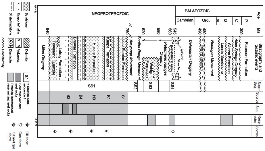
4 Figure 4 Figure 4 shows simplified stratigraphy and petroleum systems of the Neoproterozoic (Supersequence 1) of the western and central Officer Basin across the Release Areas (modified after Grey et al., 2005 and Haines et al., 2008). This is a detail of the previous Figure (3). The key source rock intervals lie in the Steptoe Formation, the Hussar Formation and the Browne Formation. Other authors include horizons within the Kanpa Formation as source intervals (see previous Figure). These formations also have indicator hydrocarbon shows, suggesting limited migration, which the Applicants further suggest makes these zones suitable shale gas/oil targets.

5 Previous Hydrocarbon Shows Table 1 shows petroleum exploration and stratigraphic wells within, and select wells and mineral drill holes adjacent to State Acreage Release Areas L12-3, L12-4 and L12-5. Shows relevant to this Application are highlighted in yellow. Data extracted from Western Australian Petroleum and Geothermal Information Management System (WAPIMS) and well completion reports and included in the Release Package. The Applicants note the strong presence of hydrocarbon shows in and around the Application Area L12-4 from within the Neoproterozoic section. These hydrocarbon occurrences provide the backbone of this Application. Figure 5 also shows the stratigraphy, but in relation to the tectonic movements in the southern Central Australia region, as well as the known distribution of hydrocarbon source, seal and reservoir rocks (from G.M. Carlsen, A.P. Simeonova and S.N. Apak, 2003). The most consistent distribution of both shows and source rocks is from Supersequence 1 (SS1) in the mid Neoproterozoic.
6 Figure 5
7 Figure 6 Figure 6 shows the detailed gamma log and lithology from GSWA Empress 1/1A (38kms west of Release Area L12-4). Whilst there are no reports of hydrocarbon shows in this particular well, the target shale horizons, for the purpose of this Application, are shown by the oil/gas symbol in the: lower Kanpa Formation; lower Hussar Formation; and mid to lower Browne Formation. The Lupton Formation (Supersequence 3) is shown in cross section B- B (below; Figure 13) as unconformably overlying a thinner Steptoe Formation, which in this figure would appear to have been included with the Kanpa Formation. The Applicants identify almost 400m of net shale in this well section, which will thicken in the troughs to the northeast. The Applicants are led to conclude that the shale gas/oil model is applicable in this basin.
8 The presumed or interpreted environments of deposition of the Kanpa and Browne Formations, in particular, are shown in Figure 7. The presence of anoxic zone shales and mudstones is of particular relevance to this Application. Figure 7 Source rock models are shown for the Neoproterozoic Kanpa and Browne formations, western Officer Basin, modified after Elphinstone and Gorter (1991) and Stein et al (1986) indicating: 1) preservation of organically rich laminae (volumetrically minor); 2) thick mudstone deposition (significant clastic dilution and oxidation); 3) proposed site of thick source rock deposition; and 4) deep water anoxic deposits. In summary, the slowly subsiding ramp margin setting of the Browne, Hussar and Kanpa formations, with widespread shallow-marine to sabkha depositional environments, was an area of high organic productivity. Rapid transport of organic matter into dysoxic to anoxic waters is critical to entrain hydrogen-rich organic material.


9 Basin Structure Figure 8 Figure 9
is absent and Supersequence 4 strata unconformably overlies the Supersequence 1.")
, in relation to existing seismic data and wells, as well as the Application Area L12-4.")
10 Figure 8 shows a NE-SW seismic line passing near to Kanpa 1A. It shows the general trough structure and the salt-lubricated thrust fault in the Browne Formation, and erosion of Supersequence 1 strata. Supersequence 3 strata (Wahgu Fm)is absent and Supersequence 4 strata unconformably overlies the Supersequence 1. Figure 9 shows a composite seismic section through Yowalga 3 and Browne 2 wells and erosion of Supersequence 1 strata between salt emplacements in the Yowalga area. Figure 10 shows the location of two orthogonal interpretive cross sections (Figures 11 & 12), in relation to existing seismic data and wells, as well as the Application Area L12-4. The oil and gas symbols on the cross sections shows where the Applicants will target the shale gas/oil approach to exploring this Permit. Figure 10: Location Map Interpretive Cross Sections

11 Application Area L12-4 Figure 11

12 Application Area L12-4 Figure 12
13 Petroleum Source Potential The Applicants acknowledge the summary presented by S.N. Apak, K.A.R. Ghori, G.M. Carlsen & M.K. Stevens (2003) Basin development with implications for Petroleum Trap Styles of the Neoprotorezoic Officer Basin, Western Australia. This analysis follows. Thin but organic-rich beds with excellent to fair oil generating potential (together with good reservoir and seal rocks) are present in the basin. Oil and gas prone source beds with fair to excellent hydrocarbon-generating potential are found in Browne 1 and 2, Empress 1/1A, Hussar 1, Kanpa 1A, LDDH 1, NJD 1, and Yowalga 3, as indicated by total organic carbon, Rock-Eval pyrolysis and rock extract analyses. Source rocks are generally mature, with the measured maturity ranging from immature to over-mature as indicated by organic petrology and Rock-Eval pyrolysis. A significantly thick part of the Neoproterozoic succession in Yowalga 3 ( m) is presently within the oil window. The present-day depth to the top of the oil window in Kanpa 1A and Yowalga 3 (Yowalga area) is about 1000 m deeper than in Hussar 1 (Gibson area; Ghori, 1998a, b). Figure 13 (from G.M. Carlsen, A.P. Simeonova and S.N. Apak, 2003) shows source rock characterisation: a) Petroleum generating potential as a function of organic richness versus potential yield, for samples interpreted as reliable; b) type of kerogen as a function of Tmax vs hydrogen index, from Rock-Eval pyrolysis; c) type of kerogen as a function of oil proneness (C5-C31 alkanes + alkenes) versus gas-oil generation index (C1-C5)/C6+) from pyrolysis-gas chromatography, (from Ghori, 2002).
14 Figure 13 Hydrocarbon Maturity in WA Release Area L12-4 The petroleum maturity of the western Officer Basin has been modelled by Ghori (2002; Modelling the hydrocarbon generative history of the Officer Basin, Western Australia). Geohistory modelling was used to analyse different geological and thermal scenarios for the evolution of the Officer Basin. It is important to determine the timing of hydrocarbon generation and the sensitivity to variations in thermal and erosional history. The Applicants have selected the Kanpa-1A model as indicative of the Application Area L12-4. This is shown in Figure 14. Maturation stages and their corresponding vitrinite reflectance values are as follows: immature zone, less than 0.5% Ro;

15 early mature for oil, 0.5% to 0.7% Ro; mid mature for oil, with some gas, 0.7% to 1.0% Ro; late mature, for oil with gas, 1.0% of 1.3% Ro; and mainly gas generation, over 1.3% Ro. The deepest equivalent vitrinite reflectance value is considered to represent the maximum maturity attained in the wells because the T max values are consistently lower than the equivalent vitrinite reflectance values in this area. The modelling suggests that the lower Kanpa Formation, and the underlying Hussar and Browne formations in Kanpa-1A, are within the mature zone for oil and gas generation. Geohistory diagram: KANPA-1A Figure 14 At this stage in the data review, the Applicants cannot reconcile the difference in indicative maturity between measured vitrinite reflectance and T max values. Conclusion: Summary of Petroleum Prospectivity in WA Release Area L12-4 The petroleum prospectivity of the western Officer Basin has been discussed by Perincek (1998), Ghori (1998, 2002, 2007), Carlsen et al. (1999, 2003), Apak and Moors (2000), Apak et al. (2002), D Ercole et al. (2005), and Simeonova and Lasky (2005). In particular, the following summary is drawn from Haines (2012) - Geology and petroleum prospectivity of State Acreage Release Areas L12-3, L12-4 and L12-5, Officer Basin, Western Australia.
16 Based on these studies, the Applicants assess the key prospectivity of the Release Areas, particularly Area L12-4, as largely restricted to sources in the early to middle Neoproterozoic Buldya Group. Although hydrocarbon shows have been small, the Neoproterozoic of the western Officer Basin shows similarities to Neoproterozoic Basins in Oman and Russia (Ghori et al., 2009). As part of the former Centralian Superbasin, the succession is also very similar to the nearby Amadeus Basin, which has recorded more significant Neoproterozoic oil and gas occurrences, including the sub-economic Dingo gasfield. There may also be similarities to the indicative shale gas/oil plays in the McArthur Basin, Northern Territory. Potential source rocks have been identified within the Browne, Kanpa, and Hussar Formations, and possibly the Steptoe Formation. If the richest of these, as identified in WMC NJD 1, thickens northeast and extends into deeper and more mature locations within the Release Areas, where it has the potential to source volumes of hydrocarbons. The widespread, though minor, hydrocarbon shows in wells across the western Officer Basin (including Kanpa 1/1A in the Application Area, L12-4) indicate that some volumes of hydrocarbons have been generated. There may have been some migration, although the Applicants do not consider this to be highly significant. Much may have remained in source shales the basis for the shale gas/oil concept being pursued by the Applicants. Maturity modelling suggests that the most significant hydrocarbon traps formed before most of the potential source rocks entered the oil window, and much of the prospective section within the thicker parts of the western Officer Basin remains in the oil-maturation window today (Ghori, 1998, 2002). The northeastern third of the Release Areas (north and east of the Western Platform Zone) is likely to be more prospective due to somewhat thicker successions. Clearly, a contingent resource assessment is virtually impossible on the limited data available. However, a basic review of the parameters suggests a resource in the range of 5 to 10tcf of gas, possibly larger.
L.K. Carr 1, R.J. Korsch 1, A.J. Mory 2, R.M. Hocking 2, S.K. Marshall 1, R.D. Costelloe 1, J. Holzschuh 1, J.L. Maher 1. Australia.
 STRUCTURAL AND STRATIGRAPHIC ARCHITECTURE OF WESTERN AUSTRALIA S FRONTIER ONSHORE SEDIMENTARY BASINS: THE WESTERN OFFICER AND SOUTHERN CARNARVON BASINS L.K. Carr 1, R.J. Korsch 1, A.J. Mory 2, R.M. Hocking
APPENDIX C GEOLOGICAL CHANCE OF SUCCESS RYDER SCOTT COMPANY PETROLEUM CONSULTANTS
 APPENDIX C GEOLOGICAL CHANCE OF SUCCESS Page 2 The Geological Chance of Success is intended to evaluate the probability that a functioning petroleum system is in place for each prospective reservoir. The
Liberty Petroleum Corporation. Liberty Petroleum Corporation L-12-5 Review
 Liberty Petroleum Corporation L-12-5 Liberty Petroleum Corporation Western Australia Officer Basin Location: Officer Basin Australia Block size: 5,600,000 Acres Operator: Liberty chosen as preferred explorer,
DEPARTMENT OF MINERALS AND ENERGY PETROLEUM SOURCE-ROCK POTENTIAL AND THERMAL HISTORY OF THE OFFICER BASIN, WESTERN AUSTRALIA RECORD 1998/3
 RECORD 1998/3 GOVERNMENT OF WESTERN AUSTRALIA PETROLEUM SOURCE-ROCK POTENTIAL AND THERMAL HISTORY OF THE OFFICER BASIN, WESTERN AUSTRALIA by K. A. R. Ghori GEOLOGICAL SURVEY OF WESTERN AUSTRALIA DEPARTMENT
BACK TO BASICS WHY THE TORRES BASIN COULD BE A COMPANY MAKER Papua New Guinea :PPL326 A Frontier Basin
 BACK TO BASICS WHY THE TORRES BASIN COULD BE A COMPANY MAKER Papua New Guinea :PPL326 A Frontier Basin 1 Tertiary Carbonate/Clastic Prospects and Leads PNG_LNG Facility PPL326 has a large number of over
A comparison of structural styles and prospectivity along the Atlantic margin from Senegal to Benin. Peter Conn*, Ian Deighton* & Dario Chisari*
 A comparison of structural styles and prospectivity along the Atlantic margin from Senegal to Benin Overview Peter Conn*, Ian Deighton* & Dario Chisari* * TGS, Millbank House, Surbiton, UK, KT6 6AP The
Bulletin of Earth Sciences of Thailand. Evaluation of the Petroleum Systems in the Lanta-Similan Area, Northern Pattani Basin, Gulf of Thailand
 Evaluation of the Petroleum Systems in the Lanta-Similan Area, Northern Pattani Basin, Gulf of Thailand Sirajum Munira Petroleum Geoscience Program, Department of Geology, Faculty of Science, Chulalongkorn
GEOLOGY AND PETROLEUM PROSPECTIVITY OF STATE ACREAGE RELEASE AREAS L13-4 AND L13-5, OFFICER BASIN, WESTERN AUSTRALIA
 Government of Western Australia Department of State Development GEOLOGY AND PETROLEUM PROSPECTIVITY OF STATE ACREAGE RELEASE AREAS L13-4 AND L13-5, OFFICER, WESTERN AUSTRALIA by Geological Survey of Western
SAND DISTRIBUTION AND RESERVOIR CHARACTERISTICS NORTH JAMJUREE FIELD, PATTANI BASIN, GULF OF THAILAND
 SAND DISTRIBUTION AND RESERVOIR CHARACTERISTICS NORTH JAMJUREE FIELD, PATTANI BASIN, GULF OF THAILAND Benjawan KIinkaew Petroleum Geoscience Program, Department of Geology, Faculty of Science, Chulalongkorn
Relinquishment Report. Licence P2016 Block 205/4c
 Relinquishment Report Licence P2016 Block 205/4c September 2016 JX Nippon Exploration and Production (U.K.) Limited Idemitsu Petroleum UK Ltd. Table of Contents 1. Licence Information... 1 2. Licence Synopsis...
Maturity Modeling of Gomin and South Gomin fields Southern Pattani Basin, Gulf of Thailand
 Maturity Modeling of Gomin and South Gomin fields Southern Pattani Basin, Gulf of Thailand Patinya Jaithan Petroleum Geoscience Program, Department of Geology, Faculty of Science, Chulalongkorn University,
Relinquishment Report
 Relinquishment Report Licence P1403 Block 13/22d Chevron North Sea Limited Korean National Oil Company Chevron North Sea Limited December 2009 1 SYNOPSIS... 3 2 INTRODUCTION. 3 2.1 Licence Terms.. 3 2.2
Petroleum geology framework, West Coast offshore region
 Petroleum geology framework, West Coast offshore region James W. Haggart* Geological Survey of Canada, Vancouver, BC jhaggart@nrcan.gc.ca James R. Dietrich Geological Survey of Canada, Calgary, AB and
Evaluation of Neocomian Shale source rock In Komombo Basin, Upper Egypt
 Evaluation of Neocomian Shale source rock In Komombo Basin, Upper Egypt Abdelhady, A. 1, Darwish, M. 2, El Araby, A. 3 and Hassouba, A. 4 1 DEA Egypt, Cairo, Egypt 2 Geology Department, Faculty of Science,
Figure 1 Extensional and Transform Fault Interaction, Influence on the Upper Cretaceous Hydrocarbon System, Equatorial Margin, West Africa.
 Figure 1 Extensional and Transform Fault Interaction, Influence on the Upper Cretaceous Hydrocarbon System, Equatorial Margin, West Africa. Presented to the 10th PESGB/HGS Conference on Africa E + P September
Triassic of the Barents Sea shelf: depositional environments and hydrocarbon potential. Daria A. Norina 1,2
 Triassic of the Barents Sea shelf: depositional environments and hydrocarbon potential Daria A. Norina 1,2 1 TOTAL (Paris, France) 2 The work is a part of PhD thesis conducted in Petroleum Department,
RWE Dea UK SNS Limited (50%, operator) Dana Petroleum (E&P) Limited (50%)
 Dana Petroleum (E&P) Limited (50%)") 1. Licence Information Licence Number P1726 Licence Round 25 th (2008) Licence Type Traditional Blocks 43/17a & 43/18a Licensees Work Programme RWE Dea UK SNS Limited (50%, operator) Dana Petroleum (E&P)
1. Licence Information Licence Number P1726 Licence Round 25 th (2008) Licence Type Traditional Blocks 43/17a & 43/18a Licensees Work Programme RWE Dea UK SNS Limited (50%, operator) Dana Petroleum (E&P)
Licence P1368: Relinquishment Report (end of 2 nd term) Hurricane Exploration PLC
 Hurricane Exploration PLC") Licence P1368: Relinquishment Report (end of 2 nd term) Hurricane Exploration PLC March 2012 1. Header Licence Number: P1368 Licence Round: 23 rd Licence Type: Frontier Block Numbers: 202/4, 202/5, 204/30,
Licence P1368: Relinquishment Report (end of 2 nd term) Hurricane Exploration PLC March 2012 1. Header Licence Number: P1368 Licence Round: 23 rd Licence Type: Frontier Block Numbers: 202/4, 202/5, 204/30,
Bulletin of Earth Sciences of Thailand. Controls on Reservoir Geometry and Distribution, Tantawan Field, Gulf of Thailand.
 Controls on Reservoir Geometry and Distribution, Tantawan Field, Gulf of Thailand Atchara Praidee Petroleum Geoscience Program, Department of Geology, Faculty of Science, Chulalongkorn University, Bangkok
L.K. Carr 1, R.J. Korsch 1, A.J. Mory 2, R.M. Hocking 2, S.K. Marshall 1, R.D. Costelloe 1, J. Holzschuh 1, J.L. Maher 1
 STRUCTURAL AND STRATIGRAPHIC ARCHITECTURE OF WESTERN AUSTRALIA S FRONTIER ONSHORE SEDIMENTARY BASINS: THE WESTERN OFFICER AND SOUTHERN CARNARVON BASINS L.K. Carr 1, R.J. Korsch 1, A.J. Mory 2, R.M. Hocking
Vail et al., 1977b. AAPG 1977 reprinted with permission of the AAPG whose permission is required for further use.
 Well 5 Well 4 Well 3 Well 2 Well 1 Vail et al., 1977b AAPG 1977 reprinted with permission of the AAPG whose permission is required for further use. Well 5 Well 4 Well 3 Well 2 Well 1 Vail et al., 1977b
MUHAMMAD S TAMANNAI, DOUGLAS WINSTONE, IAN DEIGHTON & PETER CONN, TGS Nopec Geological Products and Services, London, United Kingdom
 Geological and Geophysical Evaluation of Offshore Morondava Frontier Basin based on Satellite Gravity, Well and regional 2D Seismic Data Interpretation MUHAMMAD S TAMANNAI, DOUGLAS WINSTONE, IAN DEIGHTON
Reservoir Type and Main Controlling Factors of Reservoir Forming in Block T of South Buir Sag
 Reservoir Type and Main Controlling Factors of Reservoir Forming in Block T21-7-3 of South Buir Sag Xinyao Wang College of earth science of Northeast Petroleum University, Daqing, Heilongjiang, China Abstract
RELINQUISHMENT REPORT. UK Traditional Licence P Blocks 12/16b & 12/17b. First Oil Expro Limited (Operator, 46.67%)
") RELINQUISHMENT REPORT UK Traditional Licence P.1887 Blocks 12/16b & 12/17b First Oil Expro Limited (Operator, 46.67%) Nautical Petroleum Limited (26.67%) North Sea Energy (UK NO2) Limited (26.67%) February
RELINQUISHMENT REPORT UK Traditional Licence P.1887 Blocks 12/16b & 12/17b First Oil Expro Limited (Operator, 46.67%) Nautical Petroleum Limited (26.67%) North Sea Energy (UK NO2) Limited (26.67%) February
RELINQUISHMENT REPORT. License P1546 Block April 2009
 RELINQUISHMENT REPORT License P1546 Block 110-01 14 April 2009 Sherritt International Oil and Gas Limited 2000, 425-1 st street S.W., Calgary, Alberta Canada T2P 3L8 Telephone (403) 260-2900 Fax (403)
Investigation of Devonian Unconformity Surface Using Legacy Seismic Profiles, NE Alberta
 Investigation of Devonian Unconformity Surface Using Legacy Seismic Profiles, NE Alberta Elahe P. Ardakani and Douglas R. Schmitt Department of Physics, University of Alberta Summary The Devonian Grosmont
RELINQUISHMENT REPORT FOR LICENCE P.1663, BLOCK 29/4b and 29/5e
 RELINQUISHMENT REPORT FOR LICENCE P.1663, BLOCK 29/4b and 29/5e Licence: P.1663 Blocks: 29/4b & 29/5e 25th Round Traditional Licence Operator: Ithaca Energy UK(Ltd) 100% Work Programme Summary The agreed
For personal use only
 19 April 2013 Company Announcements Office ASX Limited 4 th Floor 20 Bridge Street Sydney NSW 2000 CANNING BASIN SPECIAL PROSPECTING AUTHORITY AWARDED AND GAZETTAL BIDS SUBMITTED Oilex awarded a Special
Geology & Geophysics Applied in Industry. EXERCISE 2: A Quick-Look Evaluation
 EXERCISE 2: A Quick-Look Evaluation You have been asked to perform a quick back-of-the-envelope evaluation of the blocks being offered off of Somewhereia. Is there enough potential that our company should
BARAKA SEEKS HELIUM & CONVENTIONAL HYDROCARBON POTENTIAL
 ASX ANNOUNCEMENT/MEDIA RELEASE 21 ST May 2018 BARAKA SEEKS HELIUM & CONVENTIONAL HYDROCARBON POTENTIAL Baraka Energy & Resources Limited (ASX: BKP) (Baraka) or (the Company) having now been recapitalized
Kilometre-Scale Uplift of the Early Cretaceous Rift Section, Camamu Basin, Offshore North-East Brazil*
 Kilometre-Scale Uplift of the Early Cretaceous Rift Section, Camamu Basin, Offshore North-East Brazil* Iain Scotchman 1 and Dario Chiossi 2 Search and Discovery Article #50183 (2009) Posted May 20, 2009
Shale Gas Potential in the Eastern Cordillera of Colombia*
 Shale Gas Potential in the Eastern Cordillera of Colombia* Mario Garcia-Gonzalez 1 Search and Discovery Article #10286 (2010) Posted December 17, 2010 *Adapted from oral presentation at AAPG International
Tetsuya Fujii. Bachelor of Geology, Shinshu University, Japan Master of Geophysics, the University of Tokyo, Japan
 USING 2D AND 3D BASIN MODELLING AND SEISMIC SEEPAGE INDICATORS TO INVESTIGATE CONTROLS ON HYDROCARBON MIGRATION AND ACCUMULATION IN THE VULCAN SUB-BASIN, TIMOR SEA, NORTH-WESTERN AUSTRALIA By Tetsuya Fujii
Licence Relinquishment Report. P.1400 Block 12/30. First Oil Expro Ltd
 Licence Relinquishment Report P.1400 Block 12/30 First Oil Expro Ltd December 2007 Seaward Production Licence P.1400, Block 12/30 Block 12/30 was awarded 100% to Reach Exploration North Sea Ltd as a promote
BALOCHISTAN FOLDBELT BASIN
 INTRODUCTION BALOCHISTAN FOLDBELT BASIN The Kharan-3 block is located in the Kharan Trough of Balochistan Basin. GEOLOGICAL SETTING The Balochistan Province is an Upper Cretaceous to Recent structurally
The McCully gas field in southern New Brunswick was discovered in the year 2000 on a joint drilling exploration venture by Corridor Resources Inc.
 1 The McCully gas field in southern New Brunswick was discovered in the year 2000 on a joint drilling exploration venture by Corridor Resources Inc. and Potash Corporation of Saskatchewan. Located about
Interaction between Faults and Igneous Intrusions in Sedimentary Basins: Insights from 3D Seismic Reflection Data*
 Interaction between Faults and Igneous Intrusions in Sedimentary Basins: Insights from 3D Seismic Reflection Data* Craig Magee¹, Christopher A. Jackson¹, and Nick Schofield² Search and Discovery Article
Tertiary Oil-Prone Coals and Carbonaceous Shales Identified as the Potential Source Rock of the Caracara Sur Oil Field in the Llanos Basin, Colombia*
 Click to view presentation slides (3 mb). Tertiary Oil-Prone Coals and Carbonaceous Shales Identified as the Potential Source Rock of the Caracara Sur Oil Field in the Llanos Basin, Colombia* M.F. García-Mayoral
Geochemical Appraisal using Vitrinite Reflectance and Rock-Eval Data, of Shishtu and Sardar Formations Central Iran
 Geochemical Appraisal using Vitrinite Reflectance and Rock-Eval Data, of Shishtu and Sardar Formations Central Iran Jahangard. A. A, Alizadeh. B, Hosseini. S. H. Department of Geology, Faculty of Earth
Structural Geology of the Mountains
 Structural Geology of the Mountains Clinton R. Tippett Shell Canada Limited, Calgary, Alberta clinton.tippett@shell.ca INTRODUCTION The Southern Rocky Mountains of Canada (Figure 1) are made up of several
Blocks 31, 32, 33, 34, 35 & 36/03 Southeast Offshore Vietnam
 Blocks 31, 32, 33, 34, 35 & 36/03 Southeast Offshore Vietnam Block 31 32 33 34 35 36/03 Area (km 2) 5,036 4,440 4,630 4,700 4,630 2,950 Sea level (m) 20 20-30 30-40 50 50 50 Seismic 2D (km) 1,294 685 431
The Kingfisher Field, Uganda - A Bird in the Hand! S R Curd, R Downie, P C Logan, P Holley Heritage Oil plc *
 A Bird in the Hand! EXTENDED ABSTRACT The Kingfisher Field, Uganda - A Bird in the Hand! Heritage Oil plc * The Kingfisher Field lies on Uganda s western border beneath Lake Albert, situated in the western
Key Elements of the Petroleum Systems of the Rockall and Slyne-Erris Basins
 Key Elements of the Petroleum Systems of the Rockall and Slyne-Erris Basins Bandon Corrib Dooish Atlantic Ireland Conference, Dublin, 1 st - 2 nd November 2016 Rockall and Slyne-Erris Basins Only 11 exploration
STRUCTURAL AND STRATIGRAPHIC ARCHITECTURE OF AUSTRALIA S FRONTIER ONSHORE SEDIMENTARY BASINS: THE ARCKARINGA, OFFICER, AMADEUS, AND GEORGINA BASINS
 STRUCTURAL AND STRATIGRAPHIC ARCHITECTURE OF AUSTRALIA S FRONTIER ONSHORE SEDIMENTARY BASINS: THE ARCKARINGA, OFFICER, AMADEUS, AND GEORGINA BASINS L.K. Carr 1, R.J. Korsch 1, W.V. Preiss 2, S. A. Menpes
Helium currently commands around US$100 per thousand cubic feet, compared to around US$3.00 in Australia for equivalent volumes of natural gas.
 TO: Manager, Company Announcements ASX Limited 280109 CONTACT: John Heugh +61 8 9474 1444 NEW RESULTS SET CENTRAL AUSTRALIA ON COURSE AS POTENTIAL GLOBAL SUPPLIER OF HELIUM GAS New geoscientific data released
PETE/GEOS 445/645 Petroleum Geology 3 credits
 PETE/GEOS 445/645 Petroleum Geology 3 credits Tuesday, Thursday 3:40-5:10 Reichardt 233 Hydrocarbons fuel today s economy, but remain a relatively rare natural resource. The objective of this course is
Tim Carr - West Virginia University
 GEOGRAPHIC EXTENT OF PETROLEUM SYSTEM A Trap Trap Trap A STRATIGRAPHIC EXTENT OF PETROLEUM SYSTEM Petroleum accumulation Top of oil window Bottom of oil window Overburden Seal Reservoir Source Underburden
Overview of Selected Shale Plays in New Mexico*
 Overview of Selected Shale Plays in New Mexico* Ron Broadhead 1 Search and Discovery Article #10627 (2014)** Posted August 18, 2014 *Adapted from presentation at RMAG luncheon meeting, Denver, Colorado,
Ministry of Oil and Minerals Petroleum Exploration & Production Authority BLOCK 85 (Al Uqlah North)
") Ministry of Oil and Minerals Petroleum Exploration & Production Authority BLOCK 85 (Al Uqlah North) The Al Uqlah North Block (85) occupies an area of 597 km 2 in the Sabatayn Basin in the province of Shabwah
Ministry of Oil and Minerals Petroleum Exploration & Production Authority BLOCK 85 (Al Uqlah North) The Al Uqlah North Block (85) occupies an area of 597 km 2 in the Sabatayn Basin in the province of Shabwah
Trapping Mechanisms along North Similan and Lanta Trends, Pattani Basin, Gulf of Thailand
 Trapping Mechanisms along North Similan and Lanta Trends, Pattani Basin, Gulf of Thailand Piyaporn Aukkanit Petroleum Geoscience Program, Department of Geology, Faculty of Science, Chulalongkorn University,
Ministry of Oil and Minerals Petroleum Exploration & Production Authority BLOCK 80 (WADI SARR)
") Ministry of Oil and Minerals Petroleum Exploration & Production Authority BLOCK 80 (WADI SARR) The Wadi Sarr Block (80) occupies an area of 1961 km 2 on the Sayun- Masilah Basin in the central Yemen. Block
Ministry of Oil and Minerals Petroleum Exploration & Production Authority BLOCK 80 (WADI SARR) The Wadi Sarr Block (80) occupies an area of 1961 km 2 on the Sayun- Masilah Basin in the central Yemen. Block
Seismic stratigraphy, some examples from Indian Ocean, interpretation of reflection data in interactive mode
 Seismic stratigraphy, some examples from Indian Ocean, interpretation of reflection data in interactive mode K. S. Krishna National Institute of Oceanography, Dona Paula, Goa-403 004. krishna@nio.org Seismic
Geochemical Evaluation of (Late Jurassic) Naokelekan Formation /Zagros Fold Belt, North Iraq
 Naokelekan Formation /Zagros Fold Belt, North Iraq") Proceeding of 3 rd scientific conference of the College Al-Ahmed Proceeding of 3 rd of Science, University of Baghdad. scientific conference, 2009, PP. 1769-1775 24 to 26 March 2009. Geochemical Evaluation
Proceeding of 3 rd scientific conference of the College Al-Ahmed Proceeding of 3 rd of Science, University of Baghdad. scientific conference, 2009, PP. 1769-1775 24 to 26 March 2009. Geochemical Evaluation
Serica Energy (UK) Limited. P.1840 Relinquishment Report. Blocks 210/19a & 210/20a. UK Northern North Sea
 Limited. P.1840 Relinquishment Report. Blocks 210/19a & 210/20a. UK Northern North Sea") Serica Energy (UK) Limited P.1840 Relinquishment Report Blocks 210/19a & 210/20a UK Northern North Sea January 2013 1 Header Licence: P.1840 Round: Licence Type: 26th Round Traditional "Drill-or-Drop"
Serica Energy (UK) Limited P.1840 Relinquishment Report Blocks 210/19a & 210/20a UK Northern North Sea January 2013 1 Header Licence: P.1840 Round: Licence Type: 26th Round Traditional "Drill-or-Drop"
Sedimentary Cycle Best Practice: Potential Eo-Oligocene Sediments in Western Indonesia*
 Sedimentary Cycle Best Practice: Potential Eo-Oligocene Sediments in Western Indonesia* Mellinda Arisandy 1 and I Wayan Darma 1 Search and Discovery Article #11008 (2017)** Posted November 6, 2017 *Adapted
Geological interpretation of seismic. Arrowie Basin, South Australia
 Geological interpretation of seismic reflection lines 08GA-A1 and 09TE-01: Arrowie Basin, South Australia L.K. Carr 1, R.J. Korsch 1, J. Holzschuh 1, Geological R.D. interpretation Costelloe 1, A.J. Meixner
RWE Dea UK SNS Limited (50%), Faroe Petroleum (UK) Limited
, Faroe Petroleum (UK) Limited") 1. Licence information Licence Number P1975 Licence Round 27 th (2012) Licence Type Traditional Blocks 3/28c & 9/3e Licensees Work Programme 2. Synopsis RWE Dea UK SNS Limited (50%), Faroe Petroleum (UK)
1. Licence information Licence Number P1975 Licence Round 27 th (2012) Licence Type Traditional Blocks 3/28c & 9/3e Licensees Work Programme 2. Synopsis RWE Dea UK SNS Limited (50%), Faroe Petroleum (UK)
Depositional History and Petroleum Potential of Ombilin Basin, West Sumatra - Indonesia, Based on Surface Geological Data*
 Depositional History and Petroleum Potential of Ombilin Basin, West Sumatra - Indonesia, Based on Surface Geological Data* Yahdi Zaim 1, Litto Habrianta 2, Chalid I. Abdullah 1, Aswan 1, Yan Rizal 1, Nurcahyo
Stratigraphic Plays in Active Margin Basin: Fluvio-Deltaic Reservoir Distribution in Ciputat Half Graben, Northwest Java Basin*
 Stratigraphic Plays in Active Margin Basin: Fluvio-Deltaic Reservoir Distribution in Ciputat Half Graben, Northwest Java Basin* Ary Wahyu Wibowo 1, Astri Pujianto 1, Wisnu Hindadari 1, Arief Wahidin Soedjono
Determination of Geothermal Gradient in the Eastern Niger Delta Sedimentary Basin from Bottom Hole Temperatures
 Journal of Earth Sciences and Geotechnical Engineering, vol. 4, no. 3, 2014, 109-114 ISSN: 1792-9040 (print), 1792-9660 (online) Scienpress Ltd, 2014 Determination of Geothermal Gradient in the Eastern
Orphan Basin, Offshore Newfoundland: New seismic data and hydrocarbon plays for a dormant Frontier Basin
 Orphan Basin, Offshore Newfoundland: New seismic data and hydrocarbon plays for a dormant Frontier Basin Jerry Smee* G&G Exploration Consulting, 301 400-3rd Avenue SW, Calgary, AB, T2P 4H2 Sam Nader, Paul
Blocks: 53/15b, 53/19, 53/20, 54/11 & 54/16. Promote Licence P1252 Two Year Report
 Blocks: 53/15b, 53/19, 53/20, 54/11 & 54/16 Promote Licence P1252 Two Year Report Wintershall Noordzee BV October 2006 Contents Contents 1 List of Figures and Tables...2 1. Licence details and work commitments...3
Update on Prospectivity Studies of the Georgina and Cooper Basins
 Update on Prospectivity Studies of the Georgina and Cooper Basins Dianne Edwards, Lisa Hall, Bridget Ayling and the Onshore Energy Systems Group, Resources Division Northern Territory, Queensland and South
Oil & Gas. From exploration to distribution. Week 1 V05 Origin of hydrocarbon resources part 1. Jean-Pierre Deflandre
 Oil & Gas From exploration to distribution Week 1 V05 Origin of hydrocarbon resources part 1 Jean-Pierre Deflandre W1V5 Origin of hydrocarbon resources1 p. 1 Introduction to hydrocarbon resources You will
Bulletin of Earth Sciences of Thailand
 Quantitative Seismic Geomorphology of Early Miocene to Pleistocene Fluvial System of Northern Songkhla Basin, Gulf of Thailand Oanh Thi Tran Petroleum Geoscience Program, Department of Geology, Faculty
EGAS. Ministry of Petroleum
 EGAS Ministry of Petroleum EGAS Ministry of Petroleum About The Block Location: N. El Arish offshore block is located in the extreme eastern part of the Egypt s economic water border and bounded from the
Education Days Moscow Closing Session
 Education Days Moscow 2013 Basin and Petroleum Systems Modelling: Applications for Conventional and Unconventional Petroleum Exploration Risk and Resource Assessments By Dr Bjorn Wygrala Schlumberger 21-22
Licence P.185, Blocks 30/11b and 30/12b Relinquishment Report February 2015
 1. General Licence: P.185 Round: 4 th (1972) Licence Type: Traditional Blocks: 30/11b (part) and 30/12b (part) Equity: Talisman Sinopec Energy UK Limited 60%, Centrica North Sea Oil Limited 40% Work Programme:
Case Study of the Structural and Depositional-Evolution Interpretation from Seismic Data*
 Case Study of the Structural and Depositional-Evolution Interpretation from Seismic Data* Yun Ling 1, Xiangyu Guo 1, Jixiang Lin 1, and Desheng Sun 1 Search and Discovery Article #20143 (2012) Posted April
Maturity assessment of Middle Cambrian organic-rich rocks in the southern Georgina Basin using geochemical and petrographic comparisons
 Maturity assessment of Middle Cambrian organic-rich rocks in the southern Georgina Basin using geochemical and petrographic comparisons Chris Boreham 1, Jane Newman 2 and Dianne Edwards 1 1 Onshore Energy
GEOCHEMISTRY OF OIL AND SOURCE ROCKS AND PETROLEUM POTENTIAL OF THE WESTERN PART OF THE BALTIC SYNECLISE Zdanaviciute, O., Dakhnova, M. V.
 GEOCHEMISTRY OF OIL AND SOURCE ROCKS AND PETROLEUM POTENTIAL OF THE WESTERN PART OF THE BALTIC SYNECLISE Zdanaviciute, O., Dakhnova, M. V., Zheglova,T. P. Content of the talk Geological framework Data
Relinquishment Report. for. Licence P1605, Block 220/27
 Relinquishment Report for Licence P1605, Block 220/27 November 2013 Licence P.1605 Relinquishment Report August 2012 1 of 11 CONTENT 1 Introduction 2 - Exploration Summary 2.1 Exploration Activity 2.2
Ministry of Oil and Minerals Petroleum Exploration & Production Authority BLOCK 6 (Iryam)
") Ministry of Oil and Minerals Petroleum Exploration & Production Authority BLOCK 6 (Iryam) The Iryam Block (6) occupies an area of 3,911 km 2 in the Sabatayn Basin in the province of Shabwah in central
Ministry of Oil and Minerals Petroleum Exploration & Production Authority BLOCK 6 (Iryam) The Iryam Block (6) occupies an area of 3,911 km 2 in the Sabatayn Basin in the province of Shabwah in central
High-resolution Sequence Stratigraphy of the Glauconitic Sandstone, Upper Mannville C Pool, Cessford Field: a Record of Evolving Accommodation
 Page No. 069-1 High-resolution Sequence Stratigraphy of the Glauconitic Sandstone, Upper Mannville C Pool, Cessford Field: a Record of Evolving Accommodation Thérèse Lynch* and John Hopkins, Department
The Paleozoic Hudson Bay Basin in Northern Canada: New Insights Into Hydrocarbon Potential of the Last North-America Conventional Frontier Basin*
 The Paleozoic Hudson Bay Basin in Northern Canada: New Insights Into Hydrocarbon Potential of the Last North-America Conventional Frontier Basin* Denis Lavoie 1, Nicolas Pinet 1, Jim Dietrich 2 and Zhuoheng
Energy potential of the Millungera Basin: a newly discovered basin in North Queensland
 Energy potential of the Millungera Basin: a newly discovered basin in North Queensland Russell Korsch 1, H. Struckmeyer 1, A. Kirkby 1, L Hutton 2, L Carr 1, K. Hoffmann 2, R. Chopping 1, I. Roy 1, M.
Comment on: Cenozoic evolution of the eastern Danish North Sea by M. Huuse, H. Lykke-Andersen and O. Michelsen, [Marine Geology 177, 243^269]
![Comment on: Cenozoic evolution of the eastern Danish North Sea by M. Huuse, H. Lykke-Andersen and O. Michelsen, [Marine Geology 177, 243^269]](/thumbs/93/112023617.jpg "Comment on: Cenozoic evolution of the eastern Danish North Sea by M. Huuse, H. Lykke-Andersen and O. Michelsen, [Marine Geology 177, 243^269]") Marine Geology 186 (2002) 571^575 Discussion Comment on: Cenozoic evolution of the eastern Danish North Sea by M. Huuse, H. Lykke-Andersen and O. Michelsen, [Marine Geology 177, 243^269] P. Japsen, T.
Marine Geology 186 (2002) 571^575 Discussion Comment on: Cenozoic evolution of the eastern Danish North Sea by M. Huuse, H. Lykke-Andersen and O. Michelsen, [Marine Geology 177, 243^269] P. Japsen, T.
Dr. Kenneth B. Taylor, P.G.
 North Carolina Forestry Association 2013 Annual Meeting October 3, 2013 Shale Gas 101: Natural Gas Exploration / Development: A North Carolina Perspective presented by Dr. Kenneth B. Taylor, P.G. State
OIL INDIA LIMITED, GEOPHYSICS DEPARTMENT, DULIAJAN, ASSAM.
 J. P. Singh, M. K. Gupta & Akshaya Kumar, Oil India Limited, Duliajan. jpsingh@oilindia.in Summary Oil exploration in Upper Assam commenced with the discovery of the Digboi oilfield more than 100 years
For personal use only
 12 October 2012 Companies Announcement Office Australian Securities Exchange Limited 10th Floor, 20 Bond Street SYDNEY NSW 2000 ADVENT ENERGY LTD SHALE GAS DATA RELEASE MEC Resources Limited (ASX:MMR)
Petroleum Systems (Part One) Source, Generation, and Migration
 Source, Generation, and Migration") Petroleum Systems (Part One) Source, Generation, and Migration GEOL 4233 Class January 2008 Petroleum Systems Elements Source Rock Migration Route Reservoir Rock Seal Rock Trap Processes Generation Migration
Petroleum Systems (Part One) Source, Generation, and Migration GEOL 4233 Class January 2008 Petroleum Systems Elements Source Rock Migration Route Reservoir Rock Seal Rock Trap Processes Generation Migration
P1125 Relinquishment Report for Blocks 30/23a, 30/27a and 30/28a
 P1125 Relinquishment Report for Blocks 30/23a, 30/27a and 30/28a Header Licence Number P1125 Licence Round 21st Round Licence Type Traditional Production Licence Block Numbers 30/23a, 30/27a and 30/28a
Hydrocarbon Charge Analysis of the SECC Block, Columbus Basin, Trinidad and Tobago
 Transactions of the 16 th Caribbean Geological Conference, Barbados. Caribbean Journal of Earth Science, 39 (2005), 21-27. Geological Society of Jamaica. Hydrocarbon Charge Analysis of the SECC Block,
Neogene Uplift of The Barents Sea
 Neogene Uplift of The Barents Sea W. Fjeldskaar A. Amantov Tectonor/UiS, Stavanger, Norway FORCE seminar April 4, 2013 The project (2010-2012) Funding companies Flat Objective The objective of the work
Image: G. Parker. Presenters: Henry Chan, Kayla Ireland, Mara Morgenstern, Jessica Palmer, Megan Scott
 Image: G. Parker Presenters: Henry Chan, Kayla Ireland, Mara Morgenstern, Jessica Palmer, Megan Scott Is the Ross Formation a suitable analog for sand-rich turbidite plays in passive margin basins? Play:
Meandering Miocene Deep Sea Channel Systems Offshore Congo, West Africa
 Meandering Miocene Deep Sea Channel Systems Offshore Congo, West Africa S. Baer* (PGS), J. E. Comstock (PGS), K. Vrålstad (PGS), R. Borsato (PGS), M. Martin (PGS), J.P. Saba (SNPC), B. Débi-Obambé (SNPC)
AAPG European Region Annual Conference Paris-Malmaison, France November RESOURCES PERSPECTIVES of the SOUTHERN PERMIAN BASIN AREA
 AAPG European Region Annual Conference Paris-Malmaison, France 23-24 November 2009 RESOURCES PERSPECTIVES of the SOUTHERN PERMIAN BASIN AREA J.C. DOORNENBAL, TNO Built, Environment and Geosciences, Geological
1. LICENCE INFORMATION. P209 Block 9/29a ALL. U.K. Block 9/29a (Part Block) Operator/Partners TAQA Bratani Ltd 81%, RWE DEA UK 19%
 Operator/Partners TAQA Bratani Ltd 81%, RWE DEA UK 19%") 1. LICENCE INFORMATION Licence P209 Block 9/29a ALL Licence Round 4th round Blocks U.K. Block 9/29a (Part Block) Licence Type Traditional (Production) Well Operator TAQA Bratani Ltd Operator/Partners TAQA
1. LICENCE INFORMATION Licence P209 Block 9/29a ALL Licence Round 4th round Blocks U.K. Block 9/29a (Part Block) Licence Type Traditional (Production) Well Operator TAQA Bratani Ltd Operator/Partners TAQA
Aptian/Albian Reservoir Development in the Jeanne d Arc Basin, Offshore Eastern Canada
 Aptian/Albian Reservoir Development in the Jeanne d Arc Basin, Offshore Eastern Canada Jonathan Marshall, Statoil Canada Ltd. Calgary, Alberta, Canada. jomars@statoil.com Introduction: The Jeanne d Arc
Depositional Environments and Hydrocarbon Potential of Northern Ionian Sea
 Depositional Environments and Hydrocarbon Potential of Northern Ionian Sea Vasiliki Kosmidou George Makrodimitras Nick Papatheodorou Contents Area of Interest Studied Dataset Workflow SWIT and Paleolatitude
Distribution of Overpressure and its Prediction in Saurashtra Dahanu Block, Western Offshore Basin, India*
 Distribution of Overpressure and its Prediction in Saurashtra Dahanu Block, Western Offshore Basin, India* Kanak R. Nambiar 1, B.K. Singh 2, R.N. Goswami 2, and K.R.K. Singh 2 Search and Discovery Article
Block 43B - Onshore Oman
 Block 43B - Onshore Oman SUMMARY Block 43B is an 11,967 km 2 area located along the coastal area of Oman north of the Hajar Mountains. This is an unexplored region, both geographically and stratigraphically.
EGAS. Ministry of Petroleum
 EGAS Ministry of Petroleum EGAS Ministry of Petroleum About The Block Location: N. Thekah offshore block is located at about 56 km to the north of the Mediterranean shore line, 85 km to the north west
Lower Skinner Valley Fill Sandstones: Attractive Exploration Targets on the Northeast Oklahoma Platform*
 Lower Skinner Valley Fill Sandstones: Attractive Exploration Targets on the Northeast Oklahoma Platform* By Jim Puckette 1 Search and Discovery Article #10050 (2003) *Adapted from presentation to Tulsa
FALCON AGG inversion to constrain 3D geological models in the Glyde Sub-Basin, Northern Territory
 FALCON AGG inversion to constrain 3D geological models in the Glyde Sub-Basin, Northern Territory Peter Kovac 1, Luke Titus 2, Carlos Cevallos 3, Josh Bluett 2, Fabio Vergara 3 1 CGG GravMag Solutions,
Relinquishment Report. for. Licences: P.1596 (Blocks 205/3, 205/4a) P.1836 (Block 205/2b) P.1837 (Block 205/5b)
 P.1836 (Block 205/2b) P.1837 (Block 205/5b)") Relinquishment Report for Licences: P.1596 (Blocks 205/3, 205/4a) P.1836 (Block 205/2b) P.1837 (Block 205/5b) November 2013 1 of 9 CONTENT 1. Header 2. Synopsis 3. Exploration Activities 4. Prospectivity
Relinquishment Report for Licences: P.1596 (Blocks 205/3, 205/4a) P.1836 (Block 205/2b) P.1837 (Block 205/5b) November 2013 1 of 9 CONTENT 1. Header 2. Synopsis 3. Exploration Activities 4. Prospectivity
UK Onshore Licence PEDL 153 Relinquishment Report September 2010
 UK Onshore Licence PEDL 153 September 2010 Licence Details Licence Number : PEDL 153 Licence Round : UK 12 th Onshore Licensing Round Effective Date: 1 October 2004 Licence Type : Petroleum Exploration
PETROLEUM GEOSCIENCES GEOLOGY OR GEOPHYSICS MAJOR
 PETROLEUM GEOSCIENCES GEOLOGY OR GEOPHYSICS MAJOR APPLIED GRADUATE STUDIES Geology Geophysics GEO1 Introduction to the petroleum geosciences GEO2 Seismic methods GEO3 Multi-scale geological analysis GEO4
Devonian Petroleum Systems and Exploration Potential, Southern Alberta, Part 3 Core Conference
 Devonian Petroleum Systems and Exploration Potential, Southern Alberta, Part 3 Core Conference Andy Mort (1), Leonard Stevens (2), Richard Wierzbicki (2) Abstract Part 1: Devonian Petroleum Systems Dr.
B.C. s Offshore Oil and Gas: a Guide to the Geology and Resources.
 B.C. s Offshore Oil and Gas: a Guide to the Geology and Resources. Introduction Beneath the offshore regions of British Columbia are four moderately large, geologically young sedimentary basins (Figure