Update on Trenton Black River Playbook Study-New York State Museum
|
|
|
- Elvin Joseph
- 5 years ago
- Views:
Transcription


1 Update on Trenton Black River Playbook Study-New York State Museum Taury Smith, Rich Nyahay, Rick Bray, Courtney Lugert, Rose Schulze and Brian Slater New York State Museum
2 Task 4: Geochemistry Task # # # # # # 1 2 Sampling from all five states Sample preparation and shipping Stable Isotope Analysis Trace Element Analysis Strontium Isotope Analysis Fluid Inclusion Analysis Data Integration and Interpretation Final report preparation?? Have sampled NY and Ohio, will ample WV tomorrow. Plan to sample KY and PA in the next two month Have prepared all NY and Ohio samples Have sent NY samples for all analyses and received results for stable isotopes and strontium isotopes
3 Accomplishments to Date All surveys given access to New York subsurface database this includes tops, scanned logs, completion reports, core photos, more Over 150 TBR wells digitized hope to have 350 more done in the next two months Have constructed isopach maps in of Ordovician intervals Have done extensive sampling for geochemistry in Ohio and NY
4 Sampling for Geochemistry Visited Ohio and met with members of Ohio and PA Surveys Thanks Mark and Ron for your hospitality and great intro and organization Took 428 samples for stable isotope analysis for both dolomite and 13 C stratigraphy Will analyze approximately 25 samples for strontium isotopes and 150 samples for trace elements Also took approximately 25 samples for fluid inclusion analysis
5 Sampling for Geochemistry Have also taken about 150 samples from three cores in New York, sent them out and received some results Should receive all data from NY geochemistry and fluid inclusions in next month
6 Sampling for Geochemistry Going to try to sample cuttings from some OH wells for 13C If this works, I encourage other surveys to send cuttings from wells where T-BR contact is hard to pick
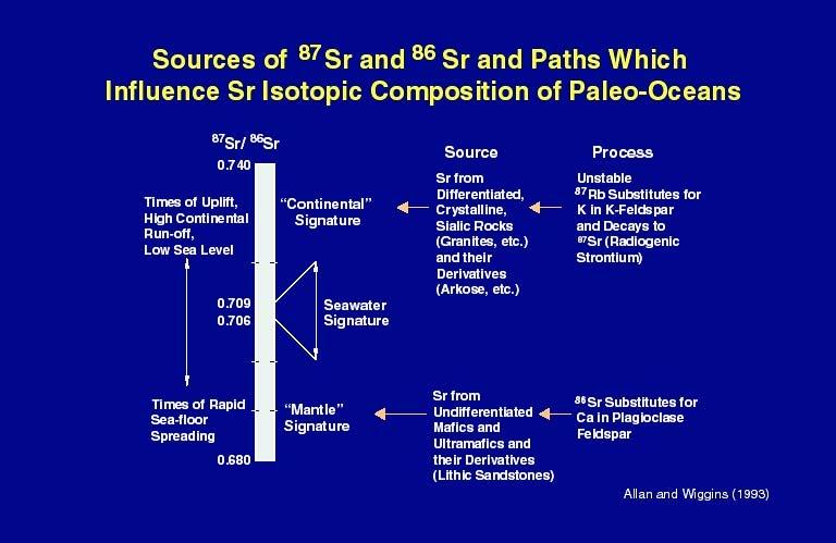
7 Davies, 2000 Oxygen isotopes are generally light (negative) in hydrothermal dolomites
8 Stable Isotopes δ13c Saddle Dolomite Matrix Dolomite Matrix Dolomite Limestone Matrix Saddle Dolomite Series δ18o
9

10 Davies, 2000 Hydrothermal dolomites typically plot as more radiogenic than seawater for the time the rocks were deposited True for TBR (barely)
11 Davies, 2000
12 Salinity of the fluid that made the dolomite can be determined from fluid inclusions TBR dolomite averages around 20 wt% (6 times normal seawater) Davies, 2000

13 Davies, 2000 With fluid inclusion data and stable isotopes, it is possible to determine the composition of the fluid which then makes direct interpretation of temperature from stable isotopes possible
 Homogenization Temperature (C) 250 200 150 100 50 0 Median 112.")
14 Homogenization Temperatures, Saddle Dolomite, Bowling Green Fault Zone (around 350 meters, probably never buried more than 1Km) Trenton (currently at 1200 ft) probably never buried more than 1 km on Findlay Arch (50ºC) Homogenization Temperature (C) Median 112.5C These temperatures suggest that TBR is truly hydrothermal, Homogenization temps>ambient temperature ever was
15 Task # # # # # # 1 2 Sampling from all five states Sample preparation and shipping Stable Isotope Analysis Trace Element Analysis Strontium Isotope Analysis Fluid Inclusion Analysis Data Integration and Interpretation Final report preparation?? Sampling all matrix and saddle dolomites and also taking samples at regular intervals for carbon isotope stratigraphy A little behind schedule, but we should be able to catch up now that we are (hopefully) getting paid


16 Dolomitized Grainstone Facies dolomite from near margin in SW Ohio


17 Fault zone in Black River. Interval around fault is dolomitized and massive calcite occurs in actual fault zone (Prudential Well)

18 Saddle dolomite cemented breccia, Spitler well, Trenton Formation, Bowling Green fault Zone

19 Post saddle dolomite blocky, calcite, Spitler well

20 Saddle dolomite in horizontal clay seam; horizontal vugs also very common


21 Cap dolomite, Top Trenton, near bowling Green Fault zone Fe stained
 Note geopetal distribution of sulfides to base of voids and saddle dolomite to tops- this was seen throughout not sure what it means Breccia is within Trenton and is thought")
22 Dolomite- and Fe-sulfidecemented breccia (First published in Wickstrom et al., 1992) Note geopetal distribution of sulfides to base of voids and saddle dolomite to tops- this was seen throughout not sure what it means Breccia is within Trenton and is thought (by me) to be a hydraulic or fault-related breccia, not a karst breccia GB well, Bowling Green Fault Zone

23 Piper, margin southwest of BG fault, Black River, looks like fracture propogating through soft sediment in shallow marine facies This suggests that the rock was not lithified and therefore pretty shallowly buried at the time of fracturing
24 Evidence for Shallow Burial at the Time of Alteration What are the implications of horizontal vugs and fractures? Horizontal fractures common from surface down to about 1500 feet, then vertical fractures take over Seismic shows faults dying out in Trenton or Utica in many cases Seismites abundant in Trenton Soft sediment deformation around fractures and faults Findlay Arch area probably never buried more than 1 km yet everything looks the same there
25 Margin Carbonate Platform Shale Basin Modified from Wickstrom et al., 1992 Contours =Trenton Limestone thickness in feet Dolomitization in Trenton occurs along margin with shale basin, around intraplatform wrench faults and at fault intersections

26 Pervasively dolomitized Modified from Wickstrom et al., 1992 Trenton Black River Facies Dolomite Reservoirs in Indiana and Ohio Pervasively dolomitized over large area but is probably all faultcontrolled hydrothermal dolomite Q: Can pervasive dolomitization be hydrothermal in origin?

27 33 outcrops of HTD in KY Orientation of hydrothermal dolomite reservoirs and some Mid-Late Ordovician structures, Eastern US
28
29 Trenton time Facies Map from Wickstrom et al., 1992 Shale Shale Shale Possible margin play This may explain the facies dolomite of Keith, 1985 in NW Ohio and Indiana (which is probably also hydrothermal in origin)
30 Could the Sebree Trough be a clay filled channel discharging from mountains? Channel may have formed in subtle low and suppressed or halted carbonate production Where else would clay come from?
31 Black River Isopach The Black River thins from the Finger Lakes Area to the East and to the northeast Feet The basin axis trends N-S then NE-SW

32 Trenton Isopach Onset of tectonic activity related to Taconic Orogeny leads to great thickness differences in Trenton Top Trenton in thickest area is laterally equivalent to Utica
33 Lorraine-Utica Isopach (Siltstone and shale overlying TBR) This map shows inverse relationship to Trenton thickness map with Utica thin where Trenton is thick Possible margin play in NY Foreland Basin
34 Lorraine-Utica Isopach Purple dots are wells with dolomite in top Black River (based on logs). Dolomite does occur in BR in basin, need more wells in margin!
35 Naylor et al., 1986 Dolomitization around Reidel Shears over right lateral strikeslip fault in Ordovician of New York


36 limestone limestone Lst Lst dolomite Dol Ordovician Tribes Hill Formation outcrop, Mohawk Valley, New York
Update on Geochemistry and Diagenetic Models. Taury Smith, Richard Nyahay and Reservoir Characterization Group
 Update on Geochemistry and Diagenetic Models Taury Smith, Richard Nyahay and Reservoir Characterization Group Biggest Well Onshore US in 2004: One of [Fortuna s] New York wells (Reed #1) produced at more
Outcrop Analog Lower Paleozoic Hydrothermal Dolomite Reservoirs, Mohawk Valley, New York
 Outcrop Analog Lower Paleozoic Hydrothermal Dolomite Reservoirs, Mohawk Valley, New York Fortuna Energy Inc. Richard Nyahay, Brian Slater, and Taury Smith New York State Museum Introduction Trenton Black
Detailed Sedimentology and Inorganic Geochemistry of the Dolgeville Formation and Utica Group of the Central Mohawk Valley, NY
 Detailed Sedimentology and Inorganic Geochemistry of the Dolgeville Formation and Utica Group of the Central Mohawk Valley, NY Daniel Miserendino Jeffrey T. Pietras Introduction and Purpose Drill cores
Calcite Cements in Middle Devonian Dunedin Formation:
 Geochemistry of the Fracture-Filling Dolomite and Calcite Cements in Middle Devonian Dunedin Formation: Implication for the Strata Dolomitization Model Sze-Shan Yip 1, Hairuo Qing 1 and Osman Salad Hersi
Relationships of the Ordovician. Appalachian Basin. June 21, 2011
 Regional Stratigraphic and Facies Relationships of the Ordovician Utica/Point i t Pleasant Interval in the Appalachian Basin June 21, 2011 Ron Riley and Mark Baranoski Stratigraphic Correlation Chart Modified
Sediment and sedimentary rocks Sediment
 Sediment and sedimentary rocks Sediment From sediments to sedimentary rocks (transportation, deposition, preservation and lithification) Types of sedimentary rocks (clastic, chemical and organic) Sedimentary
Trenton-Black River (TBR) hydrothermal dolomite (HTD) reservoir model
 hydrothermal dolomite (HTD) reservoir model") The Ontario phase of the Trenton-Black River (TBR) hydrothermal dolomite (HTD) play: Historical context and contributions to a modern exploration model Terry Carter, Ministry of Natural Resources, London,
The Ontario phase of the Trenton-Black River (TBR) hydrothermal dolomite (HTD) play: Historical context and contributions to a modern exploration model Terry Carter, Ministry of Natural Resources, London,
Structural Deformation and Karst in the Devonian Waterways Formation: Examples from Outcrops along the Athabasca River*
 Structural Deformation and Karst in the Devonian Waterways Formation: Examples from Outcrops along the Athabasca River* Chris L. Schneider 1 and Matthias Grobe 2 Search and Discovery Article #51073 (2015)
The Sequence Stratigraphic and Paleogeograhic Distribution of Reservoir-Quality Dolomite, Madison Formation, Wyoming and Montana
 The Sequence Stratigraphic and Paleogeograhic Distribution of Reservoir-Quality Dolomite, Madison Formation, Wyoming and Montana TAURY SMITH AND GREGOR EBERLI The primary aim of this study is to show the
Hydrothermal Systems as Analogs for Breached hdtraps and Subsurface Healing: Outcrop and Subsurface Examples and Escape Mechanisms
 Hydrothermal Systems as Analogs for Breached hdtraps and Subsurface Healing: Outcrop and Subsurface Examples and Escape Mechanisms David Bowen, David Lageson, Lee Spangler (Montana State University) Bryan
Upper Ordovician reefs in the Hudson Bay Basin: Porosity evolution and hydrocarbon charge
 Upper Ordovician reefs in the Hudson Bay Basin: Porosity evolution and hydrocarbon charge Denis Lavoie 1, Ariane Castagner 2, Omid Haeri Ardakani 3, André Desrochers 2 1 Geological Survey of Canada, Québec
Is It Likely That Fracking the Organic-Rich Utica Shale Beneath Bowling Green, OH Would Be Environmentally Safe?
 Is It Likely That Fracking the Organic-Rich Utica Shale Beneath Bowling Green, OH Would Be Environmentally Safe? Dr. Robert K. Vincent Prof. Emeritus, Dept. of Geology Bowling Green State University How
Sequence Stratigraphy of the Upper Cretaceous Niobrara Formation, A Bench, Wattenberg Field, Denver Julesburg Basin, Colorado*
 Sequence Stratigraphy of the Upper Cretaceous Niobrara Formation, A Bench, Wattenberg Field, Denver Julesburg Basin, Colorado* Lisa E. Remington LaChance 1 and Mark C. Robinson 1 Search and Discovery Article
Fusselman/Devonian Study. of the Midland Basin, Texas
 Fusselman/Devonian Study of the Midland Basin, Texas Fusselman-Devonian Study of the Midland Basin, Texas Overview The Fusselman-Devonian study of the Midland Basin is designed to enhance both exploration
Depositional History and Petroleum Potential of Ombilin Basin, West Sumatra - Indonesia, Based on Surface Geological Data*
 Depositional History and Petroleum Potential of Ombilin Basin, West Sumatra - Indonesia, Based on Surface Geological Data* Yahdi Zaim 1, Litto Habrianta 2, Chalid I. Abdullah 1, Aswan 1, Yan Rizal 1, Nurcahyo
11/22/2010. Groundwater in Unconsolidated Deposits. Alluvial (fluvial) deposits. - consist of gravel, sand, silt and clay
 deposits. - consist of gravel, sand, silt and clay") Groundwater in Unconsolidated Deposits Alluvial (fluvial) deposits - consist of gravel, sand, silt and clay - laid down by physical processes in rivers and flood plains - major sources for water supplies
Groundwater in Unconsolidated Deposits Alluvial (fluvial) deposits - consist of gravel, sand, silt and clay - laid down by physical processes in rivers and flood plains - major sources for water supplies
Ladyfern, N.E.B.C.: Major Gas Discovery in the Devonian Slave Point Formation
 Page No. 112-1 Ladyfern, N.E.B.C.: Major Gas Discovery in the Devonian Slave Point Formation Thomas Boreen and Kelvin Colquhoun, Apache Canada Ltd., Calgary, Alberta ABSTRACT The Upper Devonian Slave Point
Geologic Structure and Seismic Analysis
 Geologic Structure and Seismic Analysis Kentucky Geological Survey James A. Drahovzal, John B. Hickman and Paul D. Lake Trenton Black-River Research Consortium September 9, 2004 Pittsburgh, PA Structure
Geological Framework for Natural Gas Development in Central New York
 Geological Framework for Natural Gas Development in Central New York Natural Gas Development in Central New York Prepared by: Bruce Selleck Department of Geology Colgate University bselleck@mail.colgate.edu
A large Paleozoic paleokarst system in Spitsbergen Svalbard
 A large Paleozoic paleokarst system in Spitsbergen Svalbard Arild Eliassen, Statoil Classification: Internal Outline Geological setting The Spitsbergen breccias The brecciation process Seismic scale features
Fracture, Fluid Flow and Diagenetic History of the Arbuckle Group
 Fracture, Fluid Flow and Diagenetic History of the Arbuckle Group Robert H. Goldstein, Evan K. Franseen, W. Lynn Watney, Bradley King STATUS: Focused-term near completion, year 3 of 3 TIMING: Began August
Role of Geochemistry in Unconventional Resource Development. Shikha Sharma Dept. of Geology & Geography
 Role of Geochemistry in Unconventional Resource Development Shikha Sharma Dept. of Geology & Geography Role of Geochemistry OPPORTUNITIES HAVE CHANGED SOURCE = RESERVOIR Need for understanding the geological
Geologic Considerations of Shallow SAGD Caprock; Seal Capacity, Seal Geometry and Seal Integrity, Athabasca Oilsands, Alberta Canada
 Geologic Considerations of Shallow SAGD Caprock; Seal Capacity, Seal Geometry and Seal Integrity, Athabasca Oilsands, Alberta Canada Gordon T. Stabb, Michael Webb Durando Resources Corp, Suncor Energy
Origin and Evolution of Formation Waters in the West-Central Part of the Alberta Basin
 Page No. 004-1 Origin and Evolution of Formation Waters in the West-Central Part of the Alberta Basin Karsten Michael* University of Alberta, 1-26 ESB, Edmonton, AB T6G 2E3 karsten@ualberta.ca and Stefan
Lab 7: Sedimentary Structures
 Name: Lab 7: Sedimentary Structures Sedimentary rocks account for a negligibly small fraction of Earth s mass, yet they are commonly encountered because the processes that form them are ubiquitous in the
2003 GCSSEPM Foundation Ed Picou Fellowship Grant for Graduate Studies in the Earth Sciences Recipient
 2003 GCSSEPM Foundation Ed Picou Fellowship Grant for Graduate Studies in the Earth Sciences Recipient Tarek A. El Shayeb University of Texas at Austin Integrated reservoir characterization and 3-D diagenetic
Hydrothermal Dolomitization of Fluid Reservoirs in the Michigan Basin, USA* By David A. Barnes 1, Thomas M. Parris 2, and G.
 Hydrothermal Dolomitization of Fluid Reservoirs in the Michigan Basin, USA* By David A. Barnes 1, Thomas M. Parris 2, and G. Michael Grammer 1 Search and Discovery Article #50087 (2008) Posted July 10,
Follow this and additional works at: Part of the Geology Commons
 Western Michigan University ScholarWorks at WMU Michigan Geological Repository for Research and Education Geosciences 2016 Geology of Michigan William B. Harrison III Michigan Geological Repository for
UNIT 4 SEDIMENTARY ROCKS
 UNIT 4 SEDIMENTARY ROCKS WHAT ARE SEDIMENTS Sediments are loose Earth materials (unconsolidated materials) such as sand which are transported by the action of water, wind, glacial ice and gravity. These
AAPG HEDBERG RESEARCH CONFERENCE
 AAPG HEDBERG RESEARCH CONFERENCE Reservoir Scale Deformation - Characterization and Prediction June 22-28, 1997, Bryce, Utah Stratigraphic Controls on Fracture Distribution in the Austin Chalk: An Example
Seismic Geomorphology and Analysis of the Ordovician Paleokarst Drainage System in the Central Tabei Uplift, Northern Tarim Basin, Western China*
 Seismic Geomorphology and Analysis of the Ordovician Paleokarst Drainage System in the Central Tabei Uplift, Northern Tarim Basin, Western China* Hongliu Zeng 1, Robert Loucks 1, Xavier Janson 1, Quizhong
OVERVIEW OF THE ROGERSVILLE SHALE IN WEST VIRGINIA. Philip Dinterman West Virginia Geological & Economic Survey May 11, 2017
 OVERVIEW OF THE ROGERSVILLE SHALE IN WEST VIRGINIA Philip Dinterman West Virginia Geological & Economic Survey May 11, 2017 ACKNOWLEDGEMENT Dave Harris, John Hickman, Kentucky Geological Survey DATA NOTE
Mg-isotope & REE compositions of the St. George Group carbonates (WNL): Implications for the origin of dolomites & limestones
: Implications for the origin of dolomites & limestones") Mg-isotope & REE compositions of the St. George Group carbonates (WNL): Implications for the origin of dolomites & limestones K. Azmy Azmy et al., 2013. Chemical Geology 365, 64 75. Post-doc fellows Blamey,
Mg-isotope & REE compositions of the St. George Group carbonates (WNL): Implications for the origin of dolomites & limestones K. Azmy Azmy et al., 2013. Chemical Geology 365, 64 75. Post-doc fellows Blamey,
Anthill Resources Yukon - An Update on the Einarson Project
 Anthill Resources Yukon - An Update on the Einarson Project The Eastern Extension of a Carlin-type Gold Trend in the Selwyn Basin Anthill Resources Ltd Yukon Claim Holdings Over 2400 km 2 Property Location
DEVONIAN OIL AND GAS PLAYS OF THE MICHIGAN BASIN
 DEVONIAN OIL AND GAS PLAYS OF THE MICHIGAN BASIN William B. Harrison, III Michigan Geological Repository for Research and Education (MGRRE) Western Michigan University-Michigan Geological Survey 1 Devonian
Bulletin of Earth Sciences of Thailand
 Quantitative Seismic Geomorphology of Early Miocene to Pleistocene Fluvial System of Northern Songkhla Basin, Gulf of Thailand Oanh Thi Tran Petroleum Geoscience Program, Department of Geology, Faculty
Noble Gases Help Trace the Behavior of Hydrocarbons in the Crust*
 Noble Gases Help Trace the Behavior of Hydrocarbons in the Crust* Thomas Darrah 1, Robert J. Poreda 2, and Ronald Perkins 3 Search and Discovery Article #41712 (2015)** Posted October 26, 2015 *Adapted
Summary. Introduction. Observations and Interpretations
 Lower McMurray Formation sinkholes and their fill fabrics: effects of salt dissolution collapse-subsidence across the northern Athabasca oil sands deposit Paul L. Broughton, Chevron Canada Resources, Calgary,
An outcrop analogue for the Williston Basin Bakken hybrid play, the Sappington Formation in southwest Montana:
 An outcrop analogue for the Williston Basin Bakken hybrid play, the Sappington Formation in southwest Montana: Facies, stratigraphic architecture, and controls on porosity distribution Michael Hofmann
IRAQ. Target Exploration. Geodynamic Evolutions of The Sedimentary Basins of. This study is a major reference for Petroleum
 barr Target Exploration Target Exploration Geodynamic Evolutions of The Sedimentary Basins of IRAQ This study is a major reference for Petroleum Explorationists on the tectonics, stratigraphy, sedimentary
Recap and Integrated Rock Mechanics and Natural Fracture Study in the Bakken Formation, Williston Basin
 Recap and Integrated Rock Mechanics and Natural Fracture Study in the Bakken Formation, Williston Basin EERC, 2011 Cosima Theloy PhD Candidate Department of Geology and Geological Engineering Colorado
Climate History, Lake Evolution, and Predicting Organic Richness of the Green River Formation, Piceance Creek Basin, Colorado
 Climate History, Lake Evolution, and Predicting Organic Richness of the Green River Formation, Piceance Creek Basin, Colorado J. Frederick Sarg, Kati Tanavsuu-Milkeviciene, Jufang Feng, and Suriamin Huang
Michael J Kalczynski. Alexander E Gates
 Hydrothermal Mass Transfer and Magnetite Mineralization in Dilational Shear Zones, western Hudson Highlands, NY Michael J Kalczynski & Alexander E Gates Introduction Bedrock geology Shear zones & mineralized
Distinguished Lecturer David A. Ferrill. Sponsored by AAPG Foundation
 Distinguished Lecturer David A. Ferrill Sponsored by AAPG Foundation AAPG Membership Information Benefits: Monthly Receipt of AAPG Explorer & AAPG Bulletin Discounts on Books and Other Publications Registration
Strike-Slip Faults. ! Fault motion is parallel to the strike of the fault.
 Strike-Slip Faults! Fault motion is parallel to the strike of the fault.! Usually vertical, no hanging-wall/footwall blocks.! Classified by the relative sense of motion. " Right lateral opposite block
Seismic Reflection Imaging across the Johnson Ranch, Valley County, Idaho
 Seismic Reflection Imaging across the Johnson Ranch, Valley County, Idaho Report Prepared for the Skyline Corporation Lee M. Liberty Center for Geophysical Investigation of the Shallow Subsurface (CGISS)
How to Log Core (With Examples from the Williston Basin of Southeast Saskatchewan)
") How to Log Core (With Examples from the Williston Basin of Southeast Saskatchewan) D.M.Kent ( D.M.Kent Geological Consulting Ltd., Regina, Sask.), and J.H.Lake, (Lake Geological Services Inc, Swift Current,
How to Log Core (With Examples from the Williston Basin of Southeast Saskatchewan) D.M.Kent ( D.M.Kent Geological Consulting Ltd., Regina, Sask.), and J.H.Lake, (Lake Geological Services Inc, Swift Current,
The Stability Of Fault Systems In The South Shore Of The. St. Lawrence Lowlands Of Québec Implications For Shale Gas Development
 The Stability Of Fault Systems In The South Shore Of The St. Lawrence Lowlands Of Québec Implications For Shale Gas Development John Brodylo, Jean-Yves Chatellier,Guillaume Matton & Michel Rheault Copyright
Geology of the Gull Lake North ASP Flood, Upper Shaunavon Formation, Southwest Saskatchewan
 Geology of the Gull Lake North ASP Flood, Upper Shaunavon Formation, Southwest Saskatchewan By Sid Leggett, Husky Energy (sid.leggett@huskyenergy.com) Acknowledgements Husky Energy Members of the Gull
Lecture Outline Wednesday - Friday February 14-16, 2018
 Lecture Outline Wednesday - Friday February 14-16, 2018 Quiz 2 scheduled for Friday Feb 23 (Interlude B, Chapters 6,7) Questions? Chapter 6 Pages of the Past: Sedimentary Rocks Key Points for today Be
MESOZOIC BASINS. North Carolina Geological Survey
 MESOZOIC BASINS North Carolina Geological Survey The 1823 organic act which created the North Carolina Geological Survey (NCGS) tasked us to examine, describe and map the geology, geologic hazards, and
Structural Controlled Hydrothermal Dolomite Reservoirs in the Precambrian Dengying Formation of the Central Sichuan Basin, Southwestern China*
 Structural Controlled Hydrothermal Dolomite Reservoirs in the Precambrian Dengying Formation of the Central Sichuan Basin, Southwestern China* Feng Mingyou 1,2, Liu Xiaohong 1,2, Qiang Zitong 1, Tao Yanzhong
Cattaraugus Creek: A Story of Flowing Water and the Geology of the Channel It Flows Through Presentation to West Valley Citizen Task Force 4/27/16
 Cattaraugus Creek: A Story of Flowing Water and the Geology of the Channel It Flows Through Presentation to West Valley Citizen Task Force 4/27/16 Raymond C. Vaughan, Ph.D. What happens if you drop a
The geology of the Vermont Valley and the western flank of the Green Mountains between Dorset Mountain and Wallingford, Vermont
 University at Albany, State University of New York Scholars Archive Geology Theses and Dissertations Atmospheric and Environmental Sciences 1992 The geology of the Vermont Valley and the western flank
Cretaceous, Dakota Formation, Terra Cotta Member South Side of I-70, Salina County, Kansas
 Cretaceous, Dakota Formation, Terra Cotta Member South Side of I-70, Salina County, Kansas Written By: Steven D.J. Baumann G-102010-1A Outcrop looking southeast Photo taken by: Steven Baumann on 10-20-2010
Structural Features and Fracture Orientation similarities between outcrops of the Ridgeley Sandstone
 The JUNIATA JOURNAL of GEOLOGY, 1, 1-8 (2014) Original article Structural Features and Fracture Orientation similarities between outcrops of the Ridgeley Sandstone Robert W. Baronner Two outcrops of the
R E F I N I N G T H E A R T O F M I N E R A L E X P L O R A T I O N
 Jupiter Project R E F I N I N G T H E A R T O F M I N E R A L E X P L O R A T I O N Overview A large Carlin-style Au system, at least 4.5 km long and 3.5 km wide, occurs in early Paleozoic limestones and
Devonian Petroleum Systems and Exploration Potential, Southern Alberta, Part 3 Core Conference
 Devonian Petroleum Systems and Exploration Potential, Southern Alberta, Part 3 Core Conference Andy Mort (1), Leonard Stevens (2), Richard Wierzbicki (2) Abstract Part 1: Devonian Petroleum Systems Dr.
Geologic influence on variations in oil and gas production from the Cardium Formation, Ferrier Oilfield, west-central Alberta, Canada
 Geologic influence on variations in oil and gas production from the Cardium Formation, Ferrier Oilfield, west-central Alberta, Canada Marco Venieri and Per Kent Pedersen Department of Geoscience, University
 1-6 Figure 1.3. View of the field area, looking south-southwest. Left side of the picture shows the steep flank of the Green Mountain massif. The Vermont Valley and the Tinmouth Valley are separated by
A Model for Single-Phase Migration of Trenton-Black River Hydrocarbon in the Southern Michigan Basin*
 A Model for Single-Phase Migration of Trenton-Black River Hydrocarbon in the Southern Michigan Basin* Ron DeHaas 1 and Timothy Brock 2 Search and Discovery Article #10306 (2011) Posted March 14, 2011 *Adapted
EPS 50 Lab 4: Sedimentary Rocks
 Name: EPS 50 Lab 4: Sedimentary Rocks Grotzinger and Jordan, Chapter 5 Introduction In this lab we will classify sedimentary rocks and investigate the relationship between environmental conditions and
Shallow marine facies. Outline 13: The Paleozoic World. Shallow marine and terrestrial facies
 Outline 13: The Paleozoic World Shallow marine and terrestrial facies Shallow marine facies Sea level was much higher than today during much of the Paleozoic. Shallow epicontinental seas flooded continental
Rockall Plateau. OCN 201: Shelf Sediments
 Rockall Plateau OCN 201: Shelf Sediments Classification by Size Classification by Mode of Formation Detrital sediments Transported and deposited as particles Derived from weathering of pre-existing rocks
Evidence Linking Surface Lineaments, Deep-Seated Faults and Fracture-Controlled Fluid Movement in the Williston Basin
 Evidence Linking Surface Lineaments, Deep-Seated Faults and Fracture-Controlled Fluid Movement in the Williston Basin Lynden Penner J.D. Mollard and Associates Limited Regina, SK Canada 14 th Williston
Seismic Data and Drilling in Hancock Co., Kentucky February 21, 2008
 Seismic Data and Drilling in Hancock Co., Kentucky February 21, 2008 J.A. Drahovzal 2/21/08 1 Hancock County (H1) Information Provided at 2/7/08 Meeting Depth of Top (t) and Thickness (th) in feet t Kn
SITE SURVEY FOR SITE 410, AN EXAMPLE OF THE USE OF LONG-RANGE SIDE-SCAN SONAR (GLORIA)
") 10. SITE SURVEY FOR SITE 410, AN EXAMPLE OF THE USE OF LONG-RANGE SIDE-SCAN SONAR (GLORIA) R. C. Searle and A. S. Laughton, Institute of Oceanographic Sciences, Wormley, GU8 5UB, UK and B. D. Loncarevic,
10. SITE SURVEY FOR SITE 410, AN EXAMPLE OF THE USE OF LONG-RANGE SIDE-SCAN SONAR (GLORIA) R. C. Searle and A. S. Laughton, Institute of Oceanographic Sciences, Wormley, GU8 5UB, UK and B. D. Loncarevic,
GEOLOGIC MAPS PART II
 EARTH AND ENVIRONMENT THROUGH TIME LABORATORY - EES 1005 LABORATORY FIVE GEOLOGIC MAPS PART II Introduction Geologic maps of orogenic belts are much more complex than maps of the stable interior. Just
APPALACHIAN STORAGE HUB (ASH) PROJECT. Semi-Annual Meeting March 14, 2017 WVU Erickson Alumni Center
 PROJECT. Semi-Annual Meeting March 14, 2017 WVU Erickson Alumni Center") APPALACHIAN STORAGE HUB (ASH) PROJECT Semi-Annual Meeting March 14, 2017 WVU Erickson Alumni Center STRATEGY 2: STRATIGRAPHIC CORRELATION Kyle Metz Energy Resources Group, Ohio Department of Natural Resources
APPALACHIAN STORAGE HUB (ASH) PROJECT Semi-Annual Meeting March 14, 2017 WVU Erickson Alumni Center STRATEGY 2: STRATIGRAPHIC CORRELATION Kyle Metz Energy Resources Group, Ohio Department of Natural Resources
Stratigraphy and structure of the Ganson Hill area: northern Taconic Allochthon
 University at Albany, State University of New York Scholars Archive Geology Theses and Dissertations Atmospheric and Environmental Sciences 1985 Stratigraphy and structure of the Ganson Hill area: northern
Tectonic Implications of Lower Mississippian Fort Payne Carbonate Mounds. Paul L. Scruggs, Bob Hatcher, Gene Lockyear, and Francis Fitzerald
 Tectonic Implications of Lower Mississippian Fort Payne Carbonate Mounds Paul L. Scruggs, Bob Hatcher, Gene Lockyear, and Francis Fitzerald Acknowledgements Gary Bible David Wright Miller Energy Resources
16. Metamorphic Rocks II (p )
") 16. Metamorphic Rocks II (p. 233-242) Causes of Metamorphism The two main processes that occur within a rock during metamorphism are: : physical processes like squeezing and crushing - caused by strong
16. Metamorphic Rocks II (p. 233-242) Causes of Metamorphism The two main processes that occur within a rock during metamorphism are: : physical processes like squeezing and crushing - caused by strong
Overview of Woodford Gas-Shale Play in Oklahoma, 2008 Update
 Oklahoma Gas Shales Conference October 22, 2008 Overview of Woodford Gas-Shale Play in Oklahoma, 2008 Update Brian J. Cardott Oklahoma Geological Survey Number of Wells 300 250 200 Oklahoma Shale-Gas Well
Ordovician. System. Cambrian. System
 443 495 543 Late Middle Early Late Middle Early Ordovician System Cambrian System Earth History, Ch. 13 1 Ch. 13 Review: Early Paleozoic life & Burgess Shale fauna Most animal phyla originated in Cambrian;
Downloaded 10/10/13 to Redistribution subject to SEG license or copyright; see Terms of Use at
 Characterizing a fault-zone and associated fractures using lab experiments and attribute-based seismic analysis: an example from Woodford Shale, Anadarko basin, Oklahoma Zonghu Liao*, Ze ev Reches, and
Update on the Berea Sandstone Oil Play in Kentucky
 Update on the Berea Sandstone Oil Play in Kentucky Stephen F. Greb, David C. Harris, Thomas M. (Marty) Parris, Cortland F. Eble, and Brandon C. Nuttall Kentucky Geological Survey, University of Kentucky
9. SLOPE AND EMBANKMENT FAILURES
 9. SLOPE AND EMBANKMENT FAILURES 9.1 Soil Slope Failures There were some soil slope failures on the banks of roadways and along Ceyhan river (Figures 9.1, 9.2 and 9.3). These are observed Mercimekköy,Yüreğir
Fossils, Geologic Time, Absolute & Relative Dating, and Natural Resources. Chapters 5 & 6
 Fossils, Geologic Time, Absolute & Relative Dating, and Natural Resources Chapters 5 & 6 How Do Fossils Form? Fossils are found in sedimentary rocks like sandstone, limestone, and shale In Virginia, most
The Niobrara Petroleum System, Rocky Mountain Region. Steve Sonnenberg & James Taylor Colorado School of Mines
 The Niobrara Petroleum System, Rocky Mountain Region Steve Sonnenberg & James Taylor Colorado School of Mines The Niobrara-Mancos Oil & Gas Play, Rocky Mountain Region Niobrara and Mancos Production, Rocky
A Regional Diagenetic and Petrophysical Model for the Montney Formation, Western Canada Sedimentary Basin*
 A Regional Diagenetic and Petrophysical Model for the Montney Formation, Western Canada Sedimentary Basin* Noga Vaisblat 1, Nicholas B. Harris 1, Vincent Crombez 2, Tristan Euzen 3, Marta Gasparrini 2,
Maximising the use of publicly available data: porosity and permeability mapping of the Rotliegend Leman Sandstone, Southern North Sea
 Maximising the use of publicly available data: porosity and permeability mapping of the Rotliegend Leman Sandstone, Southern North Sea Claire Imrie & Henk Kombrink 09 May 2018 Overview The Oil and Gas
The McCully gas field in southern New Brunswick was discovered in the year 2000 on a joint drilling exploration venture by Corridor Resources Inc.
 1 The McCully gas field in southern New Brunswick was discovered in the year 2000 on a joint drilling exploration venture by Corridor Resources Inc. and Potash Corporation of Saskatchewan. Located about
GEOLOGY OF TODMORDEN MOOR 2 BACKGROUND
 GEOLOGY OF TODMORDEN MOOR 2 BACKGROUND 1) THE CARBONIFEROUS SERIES OF ROCKS The rocks of the Todmorden district are of the Carboniferous Series and were first laid down in an ancient sea, which covered
=%REPORT RECONNAISSANCE OF CHISHOLM LAKE PROSPECT. October 25, 1977
 =%REPORT ON FIELD RECONNAISSANCE OF CHISHOLM LAKE PROSPECT October 25, 1977 Bruce D. Vincent Imperial Oil Limited, Minerals - Coal, CALGARY, ALBERTA CHISHOLM LAKE PROSPECT Introduction The Chisholm Lake
Search and Discovery Article #10532 (2013)** Posted October 21, Abstract
** Posted October 21, Abstract") Utilizing the Delta Log R Method for Determining Total Organic Carbon of the Niobrara Formation, B Bench, Denver-Julesburg Basin, Colorado and Wyoming* Madeline K. Beitz 1, Robert Cunningham 2, and Lisa
Utilizing the Delta Log R Method for Determining Total Organic Carbon of the Niobrara Formation, B Bench, Denver-Julesburg Basin, Colorado and Wyoming* Madeline K. Beitz 1, Robert Cunningham 2, and Lisa
Chapter 6 Pages of Earth s Past: Sedimentary Rocks
 Chapter 6 Pages of Earth s Past: Sedimentary Rocks Introduction! Drilling into the bottom of the North Sea, we encounter: " Soft mud and loose sand, silt, pebbles, and shells. Then: " Similar materials
Dakota Sandstone. of the Moxa Arch and Surrounding Green River Basin
 Dakota Sandstone of the Moxa Arch and Surrounding Green River Basin Dakota Sandstones of the Green River Basin Overview The Dakota sandstones of the Moxa Arch and surrounding Green River Basin remain attractive
Elevation s Barnett Oil Play: Its Genesis and Why it Works. April 25, 2018
 Elevation s Barnett Oil Play: Its Genesis and Why it Works April 25, 2018 UL Permian Basin Position Posted: 2018 Horizontal Spuds (IHS Energy) UL 2018 Partners Forum - April 25, 2018 2 April 2013 (Elevation
GEOLOGY MEDIA SUITE Chapter 5
 UNDERSTANDING EARTH, SIXTH EDITION GROTZINGER JORDAN GEOLOGY MEDIA SUITE Chapter 5 Sedimentation Rocks Formed by Surface Processes 2010 W.H. Freeman and Company Mineralogy of sandstones Key Figure 5.12
Thickness, Compositional and Textural Variability, and Genesis of El-Lajjun Oil Shale, Central Jordan
 Thickness, Compositional and Textural Variability, and Genesis of El-Lajjun Oil Shale, Central Jordan H Alnawafleh 1, D Large 2 & B Spiro 3 1 Department of Mining Engineering, Al-Hussein Bin Talal University,
in Madison County, New York Natural Gas Development
 Natural Gas Development in Madison County, New York Bruce Selleck Department of Geology Colgate University Hamilton, NY 13346 bselleck@mail.colgate.edu Natural Gas Development in Madison County, New York
ANALYSIS OF SEISMIC PROFILES AND SIDE-SCAN SONAR RECORDS FROM LOWER NEW YORK HARBOR, A PROGRESS REPORT. Roger D. Flood Vicki Lynn Ferrini
 45 ANALYSIS OF SISMIC PROFILS AND SID-SCAN SONAR RCORDS FROM LOWR NW YORK HARBOR, A PROGRSS RPORT Roger D. Flood Vicki Lynn Ferrini Marine Sciences Research Center State University of New York, Stony Brook,
Controls on facies distributions in the Charlie Lake Formation, Peace River Arch, Alberta
 Controls on facies distributions in the Charlie Lake Formation, Peace River Arch, Alberta E.L. Percy 12, C. Frostad 2, A. Juska 2, C. Schmidt 2, C. Sitzler 2, and J.P. Zonneveld 3 University of Calgary,
Constraining the thermal history of carbonate reservoirs
 Constraining the thermal history of carbonate reservoirs Kristin Bergmann Victor P. Starr Assistant Professor Department of Earth, Atmospheric and Planetary Sciences MIT Earth Resources Laboratory 217
Diagenetic processes in the Cenozoic sedimentary formations associated with the Chicxulub Impact Crater, northwestern Yucatan Peninsula, Mexico
 The Second International Conference on Saltwater Intrusion and Coastal Aquifers Monitoring, Modeling, and Management. Mérida, Yucatán, México, March 30 - April 2, 2003 Diagenetic processes in the Cenozoic
WAMUNYU EDWARD MUREITHI I13/2358/2007
 WAMUNYU EDWARD MUREITHI I13/2358/2007 Olkaria geothermal area is situated south of Lake Naivasha on the floor of the southern segment of the Kenya rift. The geology of the Olkaria Geothermal area is subdivided
Geological Overview of the Niobrara Chalk Natural Gas Play
 Geological Overview of the Niobrara Chalk Natural Gas Play W. Lynn Watney Kansas Geological Survey KU Energy Research Center The University of Kansas Lawrence, KS Outline Geologic Setting Paleogeography
BACKGROUND GEOLOGY. Hoaglund 1. Wichita Orogeny to the south (10k 15k uplift) Rapid erosion and deposition of uplifted granitic basement rock ~18,000
 Rapid erosion and deposition of uplifted granitic basement rock ~18,000") POST APPRAISAL OF THE MISSOURIAN HOGSHOOTER HYDROCARBON SYSTEM: IMPLICATIONS FOR FUTURE EXPLOITATION IN THE ANADARKO BASIN STEVE HOAGLUND (GEOLOGIST CHESAPEAKE ENERGY) BACKGROUND GEOLOGY Wichita Orogeny
POST APPRAISAL OF THE MISSOURIAN HOGSHOOTER HYDROCARBON SYSTEM: IMPLICATIONS FOR FUTURE EXPLOITATION IN THE ANADARKO BASIN STEVE HOAGLUND (GEOLOGIST CHESAPEAKE ENERGY) BACKGROUND GEOLOGY Wichita Orogeny
Minnelusa Play: The impact of tectonics and an ancient dune field on production
 Minnelusa Play: The impact of tectonics and an ancient dune field on production Steven G. Fryberger ENHANCED OIL RECOVERY INSTITUTE Permian Tectonic Map of Wyoming 200 miles after Inden, et al, 1996 PermoPennsylvanian
Beneath the Oil Sands: Stratigraphy and Structural Features of the Devonian of Northeast Alberta, Canada*
 Beneath the Oil Sands: Stratigraphy and Structural Features of the Devonian of Northeast Alberta, Canada* Chris L. Schneider 1, Shilong Mei 1, Matthias Grobe 1, and Kristine Haug 1 Search and Discovery