Seismic Geomorphology and Analysis of the Ordovician Paleokarst Drainage System in the Central Tabei Uplift, Northern Tarim Basin, Western China*
|
|
|
- Jeffrey Hunt
- 6 years ago
- Views:
Transcription
1 Seismic Geomorphology and Analysis of the Ordovician Paleokarst Drainage System in the Central Tabei Uplift, Northern Tarim Basin, Western China* Hongliu Zeng 1, Robert Loucks 1, Xavier Janson 1, Quizhong Wang 2, Yiping Xia 2, Bingheng Yuan 2, Ligui Xu 2 Search and Discovery Article #50468 (2011) Posted September 19, 2011 *Adapted from oral presentation at AAPG Annual Convention and Exhibition, Houston, Texas, USA, April 10-13, BEG, University of Texas at Austin, Austin, TX. (hongliu.zeng@beg.utexas.edu) 2 BGP Inc., CNPC, Zhuozhou, China. Abstract High-quality 3D seismic data acquired in the central Tabei Uplift, Tarim Basin, western China, provide a rare opportunity to characterize in exceptional detail the 3D geomorphology of a deeply buried (5,500-6,500 m) Ordovician unconformity and the related paleokarst drainage system. An integrated approach was applied that emphasized integration of seismic data with available conventional core, wireline logs, and age-equivalent outcrops. The exceptional quality of the seismic data allowed a seismic detection limit of karsted features of less than m horizontally and 6 m vertically. Interpreted geomorphologic and depositional elements include fluvial channels and canyons, fluvial valleys, sinkholes, and tower karsts and hills. The modern tower karst-drainage system in Guilin, China, is very similar to the mapped Ordovician karst-drainage system and is used as a modern analog. Interaction between the surface karst-drainage system and the shallowsubsurface cave-passage system is evidenced by the observation that surface canyons appear to initiate in areas associated with intense sinkhole development. Also, surface river valleys tend to correspond to dip-oriented surface depressions partly related to near-surface cave collapse. During burial into the deeper subsurface, the combination of intrastratal collapse (karsted strata) and suprastratal collapse (postkarst deposited strata) created large damage zones hundreds of meters thick and kilometers wide. Coalesced-collapsed paleocave systems can be interpreted from the unique circular pattern of faults (observed in map view) that are associated with seismic bright spots. Copyright AAPG. Serial rights given by author. For all other rights contact author directly.
2 Reference Loucks, R.G., 1999, Paleocave carbonate reservoirs; origins, burial-depth modifications, spatial complexity, and reservoir implications: AAPG Bulletin, v. 83/11, p
3 Seismic Geomorphology and Analysis of the Ordovician Paleokarst Drainage System in the Central Tabei Uplift, Northern Tarim Basin, Western China Hongliu Zeng 1, Bob Loucks 1, Xavier Janson 1, Guizhong Wang 2, Yiping Xia 2, Bingheng Yuan 2, and Ligui Xu 2 1 : BEG, The University of Texas at Austin 2 : BGP, CNPC, China

4 Tarim Basin: study areas 530,000 sq. km
5 Presentation outline 1. Data and geologic background 2. Interpretation of paleodrainage system and nearsurface karst features at Ordovician unconformity 3. Interpretation of deeply buried, collapsed paleocave systems in Ordovician (equivalent to Ellenburger in USA)


6 3D seismic data quality 25 Hz at 7000 m! (typically Hz)
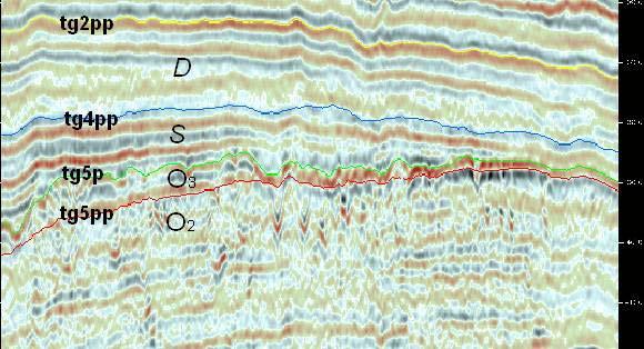
7 Stratigraphy ~6,000m Karst

8 Well-seismic correlation


9 Karst models (modified from Loucks, 1999) 2 1 At/near surface 3 4 After burial

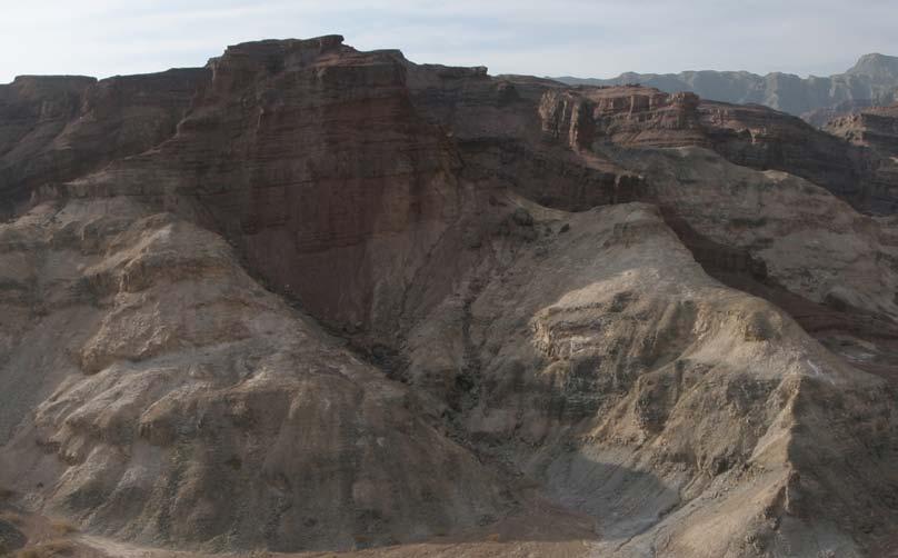
10 Outcrop photo of Ordovician unconformity


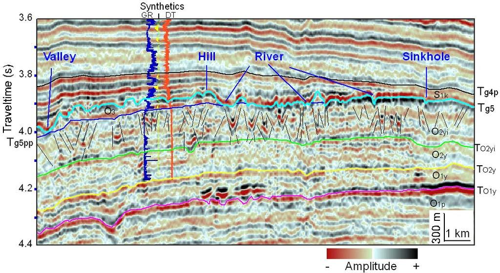
11 Paleotopography of Ordovician unconformity S N Deeper shallower N Canyon Sinkhole Karst tower valley 1 km

12 3D relief map of Ordovician unconformity


13 Modern Guilin Karst is a good analog ~150 m 100 m

14 Seismic modeling

15 Drainage system is related to nearsurface depressions and faults

16 Canyons are related to surface sinkholes
 are")

17 Surface canyons (channels) are clearly related to near-surface collapsed caves

18 Cave sediments correlate to bright spots

19 Outcrop photo of Ordovician cave breccia and sediments
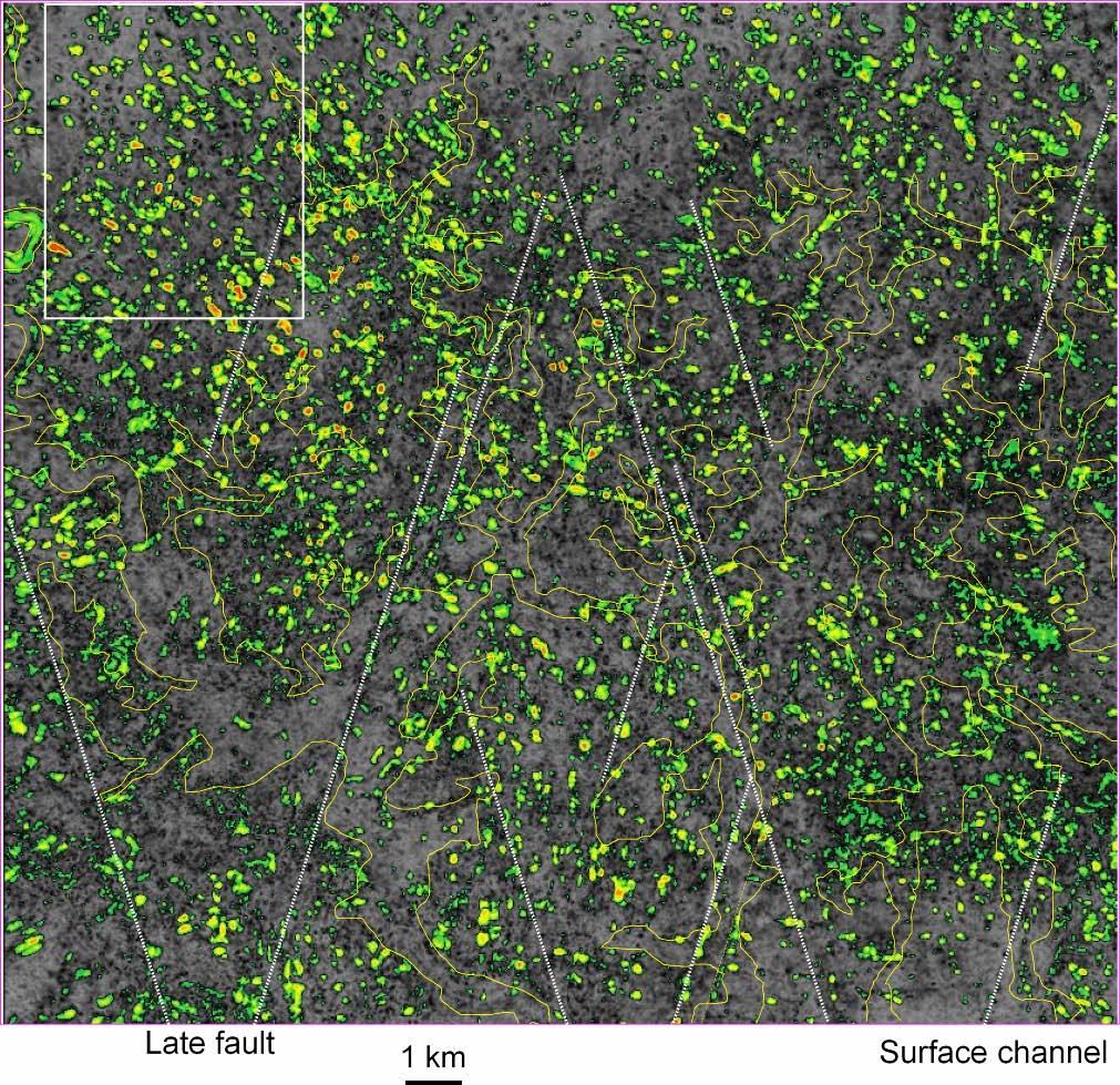
20 Distribution of bright spots

21 Interpretation of collapsed paleocave complexes (vertical slice) Size


22 Interpretation of karst-related faults using continuity (coherence) attribute

 500")
23 Interpretation of collapsed paleocave complexes (3D) Bright spot (cave sediments) 500 m Cave 30 m 100 m
24 Conclusions 1. Data quality is critical for identification of paleokarst system buried in a great depth in great detail 2. Integration (core, outcrop, and seismic) is the key for successful interpretation of complex paleocave systems 3. Surface drainage system, sinkholes, collapse features, and cave sediments are major evidence of paleocave system in the study area 4. Seismic geomorphology can be helpful in predicting paleokarst systems using 3D seismic data
25 Acknowledgments 1. BGP of CNPC is thanked for providing funds and data for the study 2. Landmark Graphics is thanked for donating seismic interpretation software
The Development of Palaeokarst Systems in the Middle Miocene Carbonate Reservoir, South Song Hong Basin
 The Development of Palaeokarst Systems in the Middle Miocene Carbonate Reservoir, South Song Hong Basin Phong Van Phung 1 *, Anh Vu The 1 and Tung Nguyen Thanh 1 1 Vietnam Petroleum Institute, Hanoi City,
Case Study of the Structural and Depositional-Evolution Interpretation from Seismic Data*
 Case Study of the Structural and Depositional-Evolution Interpretation from Seismic Data* Yun Ling 1, Xiangyu Guo 1, Jixiang Lin 1, and Desheng Sun 1 Search and Discovery Article #20143 (2012) Posted April
Conditional Simulation of Subseismic Mega Karstic Features
 Conditional Simulation of Subseismic Mega Karstic Features Amir H. Hosseini and Clayton V. Deutsch The prediction of the location and size of mega karstic features such as sinkholes and caves in carbonate
The Comparison between Full-Stack Data and Pure P-Wave Data on Deeply Buried Ordovician Paleokarst Reservoir Prediction
 Earth Science Research; Vol. 5, No. 1; 2016 ISSN 1927-0542 E-ISSN 1927-0550 Published by Canadian Center of Science and Education The Comparison between Full-Stack Data and Pure P-Wave Data on Deeply Buried
Characterizing Seal Bypass Systems at the Rock Springs Uplift, Southwest Wyoming, Using Seismic Attribute Analysis*
 Characterizing Seal Bypass Systems at the Rock Springs Uplift, Southwest Wyoming, Using Seismic Attribute Analysis* Yuri Ganshin 1 and Fred McLaughlin 1 Search and Discovery Article #80483 (2015)** Posted
Seismic Attributes and Their Applications in Seismic Geomorphology
 Academic article Seismic Attributes and Their Applications in Seismic Geomorphology Sanhasuk Koson, Piyaphong Chenrai* and Montri Choowong Department of Geology, Faculty of Science, Chulalongkorn University,
Osareni C. Ogiesoba and Angela K. Eluwa. Bureau of Economic Geology, University of Texas at Austin, Burnet Rd., Austin Texas 78759
 Structural Styles of Eocene Jackson and Oligocene Vicksburg Formations within the Rio Grande and Houston Embayments near the San Marcos Arch, Refugio and Calhoun Counties, South Texas Gulf Coast Osareni
Downloaded 01/06/15 to Redistribution subject to SEG license or copyright; see Terms of Use at
 Application of wide-azimuth 3D seismic attributes to predict the microfractures in Block MA area for shale gas exploration in South China Yusheng Zhang* 1, Gang Yu 1, Ximing Wang 1, Xing Liang 2, and Li
A large Paleozoic paleokarst system in Spitsbergen Svalbard
 A large Paleozoic paleokarst system in Spitsbergen Svalbard Arild Eliassen, Statoil Classification: Internal Outline Geological setting The Spitsbergen breccias The brecciation process Seismic scale features
Effects of Tides on Deltaic Deposition: Causes and Responses*
 Effects of Tides on Deltaic Deposition: Causes and Responses* Piret Plink-Bjorklund 1 Search and Discovery Article #50626 (2012)** Posted June 25, 2012 *Adapted from oral presentation at AAPG Annual Convention
Stratigraphic Trap Identification Based on Restoration of Paleogeophology and Further Division of System Tract: A Case Study in Qingshui Subsag*
 Stratigraphic Trap Identification Based on Restoration of Paleogeophology and Further Division of System Tract: A Case Study in Qingshui Subsag* Cao Laisheng 1, Yu Lin 1, Liu Jianlun 1, Xiang Sheng 1,
Integrating Core, Well Logs and Seismic Interpretation to Improve Understanding of Albian Patch Reefs, Maverick Basin, SW Texas * By Enzo S.
 Integrating Core, Well Logs and Seismic Interpretation to Improve Understanding of Albian Patch Reefs, Maverick Basin, SW Texas * By Enzo S. Aconcha 1 Search and Discovery Article #50104 (2008) Posted
Although most karstic regions
 Urban Geophysics: Geophysical Signature of Mount Bonnell Fault and Its Karstic Features in Austin, TX by Mustafa Saribudak, Environmental Geophysics Associates, Austin, TX Although most karstic regions
A Model for Single-Phase Migration of Trenton-Black River Hydrocarbon in the Southern Michigan Basin*
 A Model for Single-Phase Migration of Trenton-Black River Hydrocarbon in the Southern Michigan Basin* Ron DeHaas 1 and Timothy Brock 2 Search and Discovery Article #10306 (2011) Posted March 14, 2011 *Adapted
Migration Lag - What is it and how it affects Charge Risk and Fluid Properties*
 Migration Lag - What is it and how it affects Charge Risk and Fluid Properties* Zhiyong He 1 Search and Discovery Article #42014 (2017)** Posted February 20, 2017 *Adapted from oral presentation given
Global Opportunities for Offshore CCS : Assessing Offshore Storage on Continental Shelves
 Global Opportunities for Offshore CCS : Assessing Offshore Storage on Continental Shelves International Workshop on Offshore Geological CO 2 Storage Austin, Texas April 19 20, 2016 Dr. Tip Meckel, Research
Steve Cumella 1. Search and Discovery Article # (2009) Posted July 30, Abstract
 Posted July 30, Abstract") AV Geology of the Piceance Basin Mesaverde Gas Accumulation* Steve Cumella 1 Search and Discovery Article #110106 (2009) Posted July 30, 2009 *Adapted from oral presentation at AAPG Annual Convention,
AV Geology of the Piceance Basin Mesaverde Gas Accumulation* Steve Cumella 1 Search and Discovery Article #110106 (2009) Posted July 30, 2009 *Adapted from oral presentation at AAPG Annual Convention,
Update on Trenton Black River Playbook Study-New York State Museum
 Update on Trenton Black River Playbook Study-New York State Museum Taury Smith, Rich Nyahay, Rick Bray, Courtney Lugert, Rose Schulze and Brian Slater New York State Museum Task 4: Geochemistry Task 1
OIL INDIA LIMITED, GEOPHYSICS DEPARTMENT, DULIAJAN, ASSAM.
 J. P. Singh, M. K. Gupta & Akshaya Kumar, Oil India Limited, Duliajan. jpsingh@oilindia.in Summary Oil exploration in Upper Assam commenced with the discovery of the Digboi oilfield more than 100 years
Fractured Volcanic Reservoir Characterization: A Case Study in the Deep Songliao Basin*
 Fractured Volcanic Reservoir Characterization: A Case Study in the Deep Songliao Basin* Desheng Sun 1, Ling Yun 1, Gao Jun 1, Xiaoyu Xi 1, and Jixiang Lin 1 Search and Discovery Article #10584 (2014) Posted
Sequence Stratigraphy of the Upper Cretaceous Niobrara Formation, A Bench, Wattenberg Field, Denver Julesburg Basin, Colorado*
 Sequence Stratigraphy of the Upper Cretaceous Niobrara Formation, A Bench, Wattenberg Field, Denver Julesburg Basin, Colorado* Lisa E. Remington LaChance 1 and Mark C. Robinson 1 Search and Discovery Article
Search and Discovery Article #10532 (2013)** Posted October 21, Abstract
** Posted October 21, Abstract") Utilizing the Delta Log R Method for Determining Total Organic Carbon of the Niobrara Formation, B Bench, Denver-Julesburg Basin, Colorado and Wyoming* Madeline K. Beitz 1, Robert Cunningham 2, and Lisa
Utilizing the Delta Log R Method for Determining Total Organic Carbon of the Niobrara Formation, B Bench, Denver-Julesburg Basin, Colorado and Wyoming* Madeline K. Beitz 1, Robert Cunningham 2, and Lisa
Structural Deformation and Karst in the Devonian Waterways Formation: Examples from Outcrops along the Athabasca River*
 Structural Deformation and Karst in the Devonian Waterways Formation: Examples from Outcrops along the Athabasca River* Chris L. Schneider 1 and Matthias Grobe 2 Search and Discovery Article #51073 (2015)
Bulletin of Earth Sciences of Thailand
 Quantitative Seismic Geomorphology of Early Miocene to Pleistocene Fluvial System of Northern Songkhla Basin, Gulf of Thailand Oanh Thi Tran Petroleum Geoscience Program, Department of Geology, Faculty
Search and Discovery Article #40536 (2010) Posted June 21, 2010
 Posted June 21, 2010") Modern Examples of Mass Transport Complexes, Debrite and Turbidite Associations: Geometry, Stratigraphic Relationships and Implications for Hydrocarbon Trap Development* Fabiano Gamberi 1, Marzia Rovere
Modern Examples of Mass Transport Complexes, Debrite and Turbidite Associations: Geometry, Stratigraphic Relationships and Implications for Hydrocarbon Trap Development* Fabiano Gamberi 1, Marzia Rovere
Applications of Borehole Imaging to Hydrocarbon Exploration and Production
 Applications of Borehole Imaging to Hydrocarbon Exploration and Production Instructor: Philippe MONTAGGION / NExT, Schlumberger Title: Petroleum Geology Consultant Specialty: Borehole Imaging, Petroleum
The Geology of the Arbuckle Group in the Midcontinent: Sequence Stratigraphy, Reservoir Development, and the Potential for Hydrocarbon Exploration*
 The Geology of the Arbuckle Group in the Midcontinent: Sequence Stratigraphy, Reservoir Development, and the Potential for Hydrocarbon Exploration* Richard D. Fritz 1, Patrick Medlock 2, Michael J. Kuykendall
SEG/San Antonio 2007 Annual Meeting
 ; Application to Forth Worth Basin Suat Aktepe, Kurt J. Marfurt, Center for Applied Geosciences and Energy, Dept. of Geosciences, University of Houston Summary By definition, the focus of seismic exploration
The Late Tertiary Deep-Water Siliciclastic System of the Levant Margin - An Emerging Play Offshore Israel*
 The Late Tertiary Deep-Water Siliciclastic System of the Levant Margin - An Emerging Play Offshore Israel* Michael A. Gardosh 1, Yehezkel Druckman 2 and Binyamin Buchbinder 2 Search and Discovery Article
Summary. Introduction. Observations and Interpretations
 Lower McMurray Formation sinkholes and their fill fabrics: effects of salt dissolution collapse-subsidence across the northern Athabasca oil sands deposit Paul L. Broughton, Chevron Canada Resources, Calgary,
entered a rapid development phase. Annual increased proven reserves are above 500 billion cubic meters (bcm) from 2003, and annual natural gas product
 from 2003, and annual natural gas product") (), entered a rapid development phase. Annual increased proven reserves are above 500 billion cubic meters (bcm) from 2003, and annual natural gas production has increased from 50bcm in 2000 to nearly
(), entered a rapid development phase. Annual increased proven reserves are above 500 billion cubic meters (bcm) from 2003, and annual natural gas production has increased from 50bcm in 2000 to nearly
Pitfalls of seismic interpretation in prestack time- vs. depthmigration
 2104181 Pitfalls of seismic interpretation in prestack time- vs. depthmigration data Tengfei Lin 1, Hang Deng 1, Zhifa Zhan 2, Zhonghong Wan 2, Kurt Marfurt 1 1. School of Geology and Geophysics, University
Apache Egypt Companies. The introduction of 3D seismic techniques three decades ago greatly enhanced our
 Structure architecture interpretation of the middle Frio Formation using 3D seismic attributes and well logs: an example from the Texas Gulf Coast of the United States HAMED EL-MOWAFY 1 and KURT J. MARFURT
A.K. Khanna*, A.K. Verma, R.Dasgupta, & B.R.Bharali, Oil India Limited, Duliajan.
 P-92 Application of Spectral Decomposition for identification of Channel Sand Body in OIL s operational area in Upper Assam Shelf Basin, India - A Case study A.K. Khanna*, A.K. Verma, R.Dasgupta, & B.R.Bharali,
Using Curvature to Map Faults, Fractures
 Using Curvature to Map Faults, Fractures by SATINDER CHOPRA and KURT J. MARFURT Editor s note: Chopra is with Arcis Corp., Calgary, Canada; Marfurt is with the University of Oklahoma. Both are AAPG members.
Aquifers, Faults, Subsidence, and Lightning Databases
 Aquifers, Faults, Subsidence, and Lightning Databases K. S. Haggar, L. Denham, H.R. Nelson, Jr. Dynamic Measurement, LLC NOGS 1 OUTLINE 1. Introduction and Theory 2. Geologic Setting in Texas Study Area
11/22/2010. Groundwater in Unconsolidated Deposits. Alluvial (fluvial) deposits. - consist of gravel, sand, silt and clay
 deposits. - consist of gravel, sand, silt and clay") Groundwater in Unconsolidated Deposits Alluvial (fluvial) deposits - consist of gravel, sand, silt and clay - laid down by physical processes in rivers and flood plains - major sources for water supplies
Groundwater in Unconsolidated Deposits Alluvial (fluvial) deposits - consist of gravel, sand, silt and clay - laid down by physical processes in rivers and flood plains - major sources for water supplies
Stratigraphic Architecture and Key Stratigraphic Surfaces Formed by Punctuated Flow Events - An Experiment on Fluviodeltaic Responses*
 Click to view movie-steady State Click to view movie-high Flow 1 Click to view movie- Low Flow 1 Click to view movie-high Flow Click to view movie-low Flow Note: If video clips do not function properly,
Seismic modeling evaluation of fault illumination in the Woodford Shale Sumit Verma*, Onur Mutlu, Kurt J. Marfurt, The University of Oklahoma
 Seismic modeling evaluation of fault illumination in the Woodford Shale Sumit Verma*, Onur Mutlu, Kurt J. Marfurt, The University of Oklahoma Summary The Woodford Shale is one of the more important resource
Vail et al., 1977b. AAPG 1977 reprinted with permission of the AAPG whose permission is required for further use.
 Well 5 Well 4 Well 3 Well 2 Well 1 Vail et al., 1977b AAPG 1977 reprinted with permission of the AAPG whose permission is required for further use. Well 5 Well 4 Well 3 Well 2 Well 1 Vail et al., 1977b
An Amplitude-Based Modeling Method and its Application on the Impedance Inversion in Heterogeneous Paleokarst Carbonate Reservoirs
 Earth Science Research; Vol. 5, No. 2; 2016 ISSN 1927-0542 E-ISSN 1927-0550 Published by Canadian Center of Science and Education An Amplitude-Based Modeling Method and its Application on the Impedance
Holocene Lower Mississippi River Avulsions: Autogenic Versus Allogenic Forcing*
 Holocene Lower Mississippi River Avulsions: Autogenic Versus Allogenic Forcing* Eric Prokocki 1,2 Search and Discovery Article #50330 (2010) Posted October 14, 2010 *Adapted from oral presentation at AAPG
AAPG International Conference: October 24-27, 2004; Cancun, Mexico
 and Seismic Attributes in the Continental Shelf of Eastern Mexico Khaled Fouad, L. Frank Brown, Jr., William A. Ambrose, Dallas Dunlap, Bureau of Economic Geology, Jackson School of Geosciences, The University
Distribution of Overpressure and its Prediction in Saurashtra Dahanu Block, Western Offshore Basin, India*
 Distribution of Overpressure and its Prediction in Saurashtra Dahanu Block, Western Offshore Basin, India* Kanak R. Nambiar 1, B.K. Singh 2, R.N. Goswami 2, and K.R.K. Singh 2 Search and Discovery Article
Drainage Systems in Rift Basins: Implications for Reservoir Quality*
 Drainage Systems in Rift Basins: Implications for Reservoir Quality* Stephen Schwarz 1 and Lesli Wood 2 Search and Discovery Article #30477 (2016)** Posted December 5, 2016 *Adapted from oral presentation
Application of Borehole Imaging to Evaluate Porosity and Permeability in Carbonate Reservoirs: from Example from Permian Basin*
 Application of Borehole Imaging to Evaluate Porosity and Permeability in Carbonate Reservoirs: from Example from Permian Basin* D.V. (Vivek) Chitale 1, Clive Johnson 2, Hunter Manley 3, David Entzminger
Exploration Significance of Unconformity Structure on Subtle Pools. 1 Vertical structure characteristics of unconformity
 Exploration Significance of Unconformity Structure on Subtle Pools Wu Kongyou (China University of Petroleum,College of Geo-Resources and Information,Shandong Qingdao 266555) Abstract: Vertical structure
By: Jared T. Freiburg Illinois State Geological Survey 5/17/ cm
 Current Research on the Mt. Simon Geology; Refining the Lower Mt. Simon Depositional Interpretation By: Jared T. Freiburg Illinois State Geological Survey freiburg@illinois.edu 5/17/2016 2.5 cm Collaborators
Cenozoic Extensional Basin Development and Sedimentation in SW Montana
 Cenozoic Extensional Basin Development and Sedimentation in SW Montana Robert C. Thomas Department of Environmental Sciences, The University of Montana Western, Dillon, MT 59725, (406) 683-7615, r_thomas@umwestern.edu
Shallow P and S velocity structure, Red Deer, Alberta
 Shallow P and S velocity structure, Red Deer, Alberta P & S velocity structure Don C. Lawton, Meredith A. McArthur, Rachel T. Newrick and Sarah E. Trend ABSTRACT A multioffset vertical seismic profile
Summary. (a) (b) Introduction
 (b) Introduction") er well in AC 818, Gulf of Mexico Cam Kanhalangsy, Nick Golubev, Jurgen Johann Zach, Daniel Baltar*, EMGS Americas Summary We present anisotropic 2.5D inversion examples illustrating the possibility to
er well in AC 818, Gulf of Mexico Cam Kanhalangsy, Nick Golubev, Jurgen Johann Zach, Daniel Baltar*, EMGS Americas Summary We present anisotropic 2.5D inversion examples illustrating the possibility to
Caspian Sea Geohazard Features
 Caspian Sea Geohazard Features Lev MERKLIN and Victoria PUTANS P.P.Shirshov Institute of oceanology, Russian Academy of Sciences 117997, Moscow, Nakhimovsky prospekt, 36 E-mail: lmerklin@ocean.ru HYDRO-2010
Quantitative Seismic Geomorphology of Fluvial Systems of the Pleistocene to Recent in the Malay Basin, Southeast Asia*
 Quantitative Seismic Geomorphology of Fluvial Systems of the Pleistocene to Recent in the Malay Basin, Southeast Asia* Faisal Alqahtani 1, Christopher Jackson 1, Howard Johnson 1, Alex Davis 2, and Ammar
Reservoir Modelling of a Bioclastic Calcarenite Complex on Favignana, Southern Italy: The Application of Multi-point Statistics*
 Reservoir Modelling of a Bioclastic Calcarenite Complex on Favignana, Southern Italy: The Application of Multi-point Statistics* Robert Kil 1 and Andrea Moscariello 2,3 Search and Discovery Article #50548
Seismic Expressions of Submarine Channel - Levee Systems and Their Architectural Elements
 Seismic Expressions of Submarine Channel - Levee Systems and Their Architectural Elements Summary D.V. Ramana, Santanu De* and Kalyanbrata Datta KDMIPE, ONGC, Dehradun E-mail- devvenram@rediffmail.com
Osareni C. Ogiesoba 1. Search and Discovery Article #10601 (2014)** Posted May 31, 2014
** Posted May 31, 2014") Seismic Multiattribute Analysis for Shale Gas/Oil within the Austin Chalk and Eagle Ford Shale in a Submarine Volcanic Terrain, Maverick Basin, South Texas* Osareni C. Ogiesoba 1 Search and Discovery Article
Seismic Multiattribute Analysis for Shale Gas/Oil within the Austin Chalk and Eagle Ford Shale in a Submarine Volcanic Terrain, Maverick Basin, South Texas* Osareni C. Ogiesoba 1 Search and Discovery Article
II CENTRAL & NORTH ATLANTIC CONJUGATE MARGINS CONFERENCE
 http://metododirecto.pt/cm2010 IB: 978-989-96923-1-2 Volume VI p. 167-171 II CETRAL & ORTH ATLATIC COJUGATE MARGI COFERECE Hydrocarbon Prospectivity of a ew Deepwater Petroleum Province, Offshore enegal
The Sequence Stratigraphic and Paleogeograhic Distribution of Reservoir-Quality Dolomite, Madison Formation, Wyoming and Montana
 The Sequence Stratigraphic and Paleogeograhic Distribution of Reservoir-Quality Dolomite, Madison Formation, Wyoming and Montana TAURY SMITH AND GREGOR EBERLI The primary aim of this study is to show the
The coherence cube. MIKE BAHORICH Amoco Corporation Denver, CO. Faults parallel to strike. Conventional amplitude time
 3-D seismic discontinuity for faults and stratigraphic features: The coherence cube MIKE BAHORICH Amoco Corporation Denver, CO STEVE FARMER Amoco Corporation Tulsa, OK Seismic data are usually acquired
THE NORPHLET SANDSTONE AND OTHER PETROLEUM PLAYS ALONG AND OUTBOARD OF THE FLORIDA ESCARPMENT, EASTERN GULF OF MEXICO
 THE NORPHLET SANDSTONE AND OTHER PETROLEUM PLAYS ALONG AND OUTBOARD OF THE FLORIDA ESCARPMENT, EASTERN GULF OF MEXICO Glyn Roberts 1, Joe Erickson 2 1 Consultant, Bedford, UK; 2 Spectrum, Houston, TX.
Geoscience 001 Fall Rock Identification and Contextual Interpretation
 Geoscience 00 Fall 2005 Rock Identification and Contextual Interpretation The purpose of this week s lab is to gain some more experience and practice in identifying rocks and then interpreting the geologic
Quantitative Seismic Interpretation An Earth Modeling Perspective
 Quantitative Seismic Interpretation An Earth Modeling Perspective Damien Thenin*, RPS, Calgary, AB, Canada TheninD@rpsgroup.com Ron Larson, RPS, Calgary, AB, Canada LarsonR@rpsgroup.com Summary Earth models
Pre-stack inversion for caved carbonate reservoir prediction: A case study from Tarim Basin, China
 Pet.Sci.(211)8:415-421 DOI 1.17/s12182-11-159-4 415 Pre-stack inversion for caved carbonate reservoir prediction: A case study from Tarim Basin, China Zhang Yuanyin 1, Sam Zandong Sun 1, Yang Haijun 2,
Seismic Reflection Profiling: An Effective Exploration Tool in the Athabasca Basin? An Interim Assessment
 Seismic Reflection Profiling: An Effective Exploration Tool in the Athabasca Basin? An Interim Assessment D.J. White 1, B. Roberts 1, C. Mueller 1, Z. Hajnal 2, I. Gyorfi 2, B. Reilkoff 2, R. Koch 3, and
Economic Geology Unconventional Energy Research
 Bureau of Economic Geology Unconventional Energy Research Overview for CEE meeting December, 2011 QAd2349x BUREAU OF ECONOMIC GEOLOGY Oldest research unit of The University of Texas at Austin Geological
Controls on clastic systems in the Angoche basin, Mozambique: tectonics, contourites and petroleum systems
 P2-2-13 Controls on clastic systems in the Angoche basin, Mozambique: tectonics, contourites and petroleum systems Eva Hollebeek, Olivia Osicki, Duplo Kornpihl Schlumberger, London, UK Introduction Offshore
Multiattributes and Seismic Interpretation of Offshore Exploratory Block in Bahrain A Case Study
 Multiattributes and Seismic Interpretation of Offshore Exploratory Block in Bahrain A Case Study Suresh Thampi, Aqeel Ahmed, Yahya Al-Ansari, Ali Shehab, Ahmed Fateh, Anindya Ghosh, Ghada Almoulani. The
Southern Songkhla Basin, Gulf of Thailand
 Architecture and Depositional Environment of Fluvial Systems of Southern Songkhla Basin, Gulf of Thailand Toan Manh Do Petroleum Geoscience Program, Department of Geology, Faculty of Science, Chulalongkorn
Summary. Introduction
 Xian Qiang*, Liu Yonglei, Lv Dong, An Haiting, He Xiaosong, Li Haiyin, Xiao Yong, Zhou Chenguang, Xu Jianyang, Dong Lei,and Mao Xianyu,BGP,CNPC Summary Although high density, FAZ(Full azimuth) seismic
surface uplift of fault-related folds rely primarily on their limbs and associated
 Finite and Quaternary shortening calculation Finite shortening Models commonly used to constrain the structural evolution, shortening, and surface uplift of fault-related folds rely primarily on their
Characteristics of stratigraphic structure and oil-gas-water distribution by logging data in Arys oilfield
 31 1 2012 3 GLOBAL GEOLOGY Vol. 31 No. 1 Mar. 2012 1004 5589 2012 01 0162 09 100101 4 P618. 130. 2 P631. 8 A doi 10. 3969 /j. issn. 1004-5589. 2012. 01. 020 Characteristics of stratigraphic structure and
EMERGENCY INVESTIGATION OF EXTREMELY LARGE SINKHOLES, MAOHE, GUANGXI, CHINA
 EMERGENCY INVESTIGATION OF EXTREMELY LARGE SINKHOLES, MAOHE, GUANGXI, CHINA Mingtang Lei, Xiaozhen Jiang, Zhende Guan Institute of Karst Geology, CAGS, Guilin, China, mingtanglei@hotmail.com Yongli Gao
Quantitative Relation of the Point BarWidth and Meander Belt Width of Subsurface Reservoir
 Advances in Petroleum Exploration and Development Vol. 13, No. 1, 2017, pp. 17-24 DOI:10.3968/9465 ISSN 1925-542X [Print] ISSN 1925-5438 [Online] www.cscanada.net www.cscanada.org Quantitative Relation
Casablanca Field, a depleted karstic oil reservoir for geological storage of CO2
 Casablanca Field, a depleted karstic oil reservoir for geological storage of CO2 Virginie Mignot 1, Yann Le Gallo **1, Jean-Claude Lecomte 1, Tristan Euzen 1, Tomas Vallaure 2, Juan Mallo 2 1 Institut
We A Multi-Measurement Integration Case Study from West Loppa Area in the Barents Sea
 We-16-12 A Multi-Measurement ntegration Case Study from West Loppa Area in the Barents Sea. Guerra* (WesternGeco), F. Ceci (WesternGeco), A. Lovatini (WesternGeco), F. Miotti (WesternGeco), G. Milne (WesternGeco),
Geometric attributes such as coherence and curvature are
 SATINDER CHOPRA, Arcis Seismic Solutions, Calgary, Canada KURT J. MARFURT, University of Oklahoma, Norman, USA Geometric attributes such as coherence and curvature are commonly used for mapping structural
The Late Quaternary Rio Grande Delta A Distinctive, Underappreciated Geologic System
 The Late Quaternary Rio Grande Delta A Distinctive, Underappreciated Geologic System Thomas E. Ewing 1 and Juan L. Gonzalez 2 1 Frontera Exploration Consultants, 19240 Redland Rd., Ste. 250, San Antonio,
 Tutors: Huw Williams & Paul Davies (Reservoir Geology Consultants Limited) Duration: A six day field and classroom-based reservoir geology and modelling course in Grand Junction, Colorado and Green River,
The McCully gas field in southern New Brunswick was discovered in the year 2000 on a joint drilling exploration venture by Corridor Resources Inc.
 1 The McCully gas field in southern New Brunswick was discovered in the year 2000 on a joint drilling exploration venture by Corridor Resources Inc. and Potash Corporation of Saskatchewan. Located about
Sequence Stratigraphy: An Applied Workshop
 Sequence Stratigraphy: An Applied Workshop Instructor: Prof. Octavian Catuneanu Level: Intermediate Duration: 5 days Course Description and Objectives This workshop presents the concepts and practical
Hydrocarbon Charge Analysis of the SECC Block, Columbus Basin, Trinidad and Tobago
 Transactions of the 16 th Caribbean Geological Conference, Barbados. Caribbean Journal of Earth Science, 39 (2005), 21-27. Geological Society of Jamaica. Hydrocarbon Charge Analysis of the SECC Block,
Geophysical Methods for Screening and Investigating Utility Waste Landfill Sites in Karst Terrain
 Geophysical Methods for Screening and Investigating Utility Waste Landfill Sites in Karst Terrain Gary Pendergrass, PE, RG, F.NSPE Principal Geological Engineer Kansas City Geotechnical Conference 2017
Enhancing Reservoir Characterization using Lightning Strike Data
 Enhancing Reservoir Characterization using Lightning Strike Data H. Roice Nelson, Jr., Dr. Jim Siebert, & Les R. Denham Dynamic Measurement LLC Outline Lighting Databases: a new geophysical data type Idea
Maturity Modeling of Gomin and South Gomin fields Southern Pattani Basin, Gulf of Thailand
 Maturity Modeling of Gomin and South Gomin fields Southern Pattani Basin, Gulf of Thailand Patinya Jaithan Petroleum Geoscience Program, Department of Geology, Faculty of Science, Chulalongkorn University,
Application of Multi-Attributes and Spectral Decomposition with RGB blending for understanding the strati-structural features: A Case study
 10 th Biennial International Conference & Exposition P 262 Application of Multi-Attributes and Spectral Decomposition with RGB blending for understanding the strati-structural features: A Case study Summary
The Paleozoic Hudson Bay Basin in Northern Canada: New Insights Into Hydrocarbon Potential of the Last North-America Conventional Frontier Basin*
 The Paleozoic Hudson Bay Basin in Northern Canada: New Insights Into Hydrocarbon Potential of the Last North-America Conventional Frontier Basin* Denis Lavoie 1, Nicolas Pinet 1, Jim Dietrich 2 and Zhuoheng
GIS Project: Study on Gulf of Mexico basin provenance in Lower Miocene
 GIS Project: Study on Gulf of Mexico basin provenance in Lower Miocene Introduction Background: The Lower Miocene of the Gulf of Mexico (GOM) Basin is a transitional unit from many respects. It is a time
Search and Discovery Article # (2015) Posted April 20, 2015
 Posted April 20, 2015") Considering the Vertical Variation in Rock Mechanical Properties of a Lithologic Zone Using Laboratory Derived Data Is it Time for Geomechanical Stratigraphy?* Douglas E. Wyatt 1, Jesse Hampton 1, Dandan
Considering the Vertical Variation in Rock Mechanical Properties of a Lithologic Zone Using Laboratory Derived Data Is it Time for Geomechanical Stratigraphy?* Douglas E. Wyatt 1, Jesse Hampton 1, Dandan
Today you will be able to: Utilize the SEVEN rules of rock age identification to describe the geologic age of this rock sequence!
 Mr. Sandomenico Welcome!!!! Today we will begin a new unit! The Earth s History!!!!! Today you will be able to: Utilize the SEVEN rules of rock age identification to describe the geologic age of this rock
Meandering Miocene Deep Sea Channel Systems Offshore Congo, West Africa
 Meandering Miocene Deep Sea Channel Systems Offshore Congo, West Africa S. Baer* (PGS), J. E. Comstock (PGS), K. Vrålstad (PGS), R. Borsato (PGS), M. Martin (PGS), J.P. Saba (SNPC), B. Débi-Obambé (SNPC)
Investigation of Devonian Unconformity Surface Using Legacy Seismic Profiles, NE Alberta
 Investigation of Devonian Unconformity Surface Using Legacy Seismic Profiles, NE Alberta Elahe P. Ardakani and Douglas R. Schmitt Department of Physics, University of Alberta Summary The Devonian Grosmont
3-D ground-penetrating radar surveys on a frozen river lagoon
 3-D ground-penetrating radar surveys on a frozen river lagoon Monica Moldoveanu and Robert R. tewart ABTRACT Ground-penetrating radar (GPR) surveys were acquired at Bowness Park, Calgary to characterize
Arthur Saller 1. Search and Discovery Article #51393 (2017)** Posted June 26, Abstract
** Posted June 26, Abstract") PS Mixed Carbonates and Siliciclastics North of the Mahakam Delta, Offshore East Kalimantan, Indonesia* Arthur Saller 1 Search and Discovery Article #51393 (2017)** Posted June 26, 2017 *Adapted from poster
PS Mixed Carbonates and Siliciclastics North of the Mahakam Delta, Offshore East Kalimantan, Indonesia* Arthur Saller 1 Search and Discovery Article #51393 (2017)** Posted June 26, 2017 *Adapted from poster
Seismic stratigraphy, some examples from Indian Ocean, interpretation of reflection data in interactive mode
 Seismic stratigraphy, some examples from Indian Ocean, interpretation of reflection data in interactive mode K. S. Krishna National Institute of Oceanography, Dona Paula, Goa-403 004. krishna@nio.org Seismic
: Morondava Basin, Offshore Madagascar New Long Offset Seismic Data highlights the Petroleum Prospectivity of this Emerging Frontier Basin.
 1555684: Morondava Basin, Offshore Madagascar New Long Offset Seismic Data highlights the Petroleum Prospectivity of this Emerging Frontier Basin. Glyn Roberts(1); Trond Christoffersen(2); Huang Weining(3).
Colombia s Offshore*
 PS A Seismic-Structural Interpretation, on the Identification of Possible Causes in the Formation of Gas Chimneys in Colombia s Offshore* Tatiana Mayorga 1, Andrés E. Calle 2, Freddy M. Niño 2, Jorge Rubiano
CONTRIBUTION OF SATELLITE IMAGERY TO SEARCH CLUES OF SURFACE DRAINAGE WITHIN AAC
 Pléiades Days, 2014 CONTRIBUTION OF SATELLITE IMAGERY TO SEARCH CLUES OF SURFACE DRAINAGE WITHIN 1. Methods, remote sensing 2. Applications of achieved results 3. Contact : Sébastien RUCQUOI & Christelle
Delineating Karst features using Advanced Interpretation
 P-152 Asheesh Singh, Sibam Chakraborty*, Shafique Ahmad Summary We use Amplitude, Instantaneous Phase, Trace Envelope and Dip of Maximum Similarity Attributes as a tool to delineate Karst induced features
S. Mangal, G.L. Hansa, S. R. Savanur, P.H. Rao and S.P. Painuly Western Onshore Basin, ONGC, Baroda. INTRODUCTION
 5th Conference & Exposition on Petroleum Geophysics, Hyderabad-2004, India PP 782-787 Identification of Shallow Gas Prospects from DHI and Inversion Studies of 2D Seismic Data, Kosamba Oil field, South
Comment on: Cenozoic evolution of the eastern Danish North Sea by M. Huuse, H. Lykke-Andersen and O. Michelsen, [Marine Geology 177, 243^269]
![Comment on: Cenozoic evolution of the eastern Danish North Sea by M. Huuse, H. Lykke-Andersen and O. Michelsen, [Marine Geology 177, 243^269]](/thumbs/93/112023617.jpg "Comment on: Cenozoic evolution of the eastern Danish North Sea by M. Huuse, H. Lykke-Andersen and O. Michelsen, [Marine Geology 177, 243^269]") Marine Geology 186 (2002) 571^575 Discussion Comment on: Cenozoic evolution of the eastern Danish North Sea by M. Huuse, H. Lykke-Andersen and O. Michelsen, [Marine Geology 177, 243^269] P. Japsen, T.
Marine Geology 186 (2002) 571^575 Discussion Comment on: Cenozoic evolution of the eastern Danish North Sea by M. Huuse, H. Lykke-Andersen and O. Michelsen, [Marine Geology 177, 243^269] P. Japsen, T.