in Madison County, New York Natural Gas Development
|
|
|
- Jason Shepherd
- 5 years ago
- Views:
Transcription

1 Natural Gas Development in Madison County, New York Bruce Selleck Department of Geology Colgate University Hamilton, NY
2 Natural Gas Development in Madison County, New York Prepared by: Bruce Selleck Department of Geology Colgate University Natural gas is a fossil fuel that is derived from ancient, buried organic matter. Natural gas is a mixture of methane, ethane, propane and butane, and is found in many sedimentary rocks. For the gas to be extracted in commercially viable amounts, a source of gas, a natural reservoir system and a caprock or seal on the reservoir must all exist. Natural gas wells have been drilled in Madison County since the late 19 th century. Small fields in the Towns of Brookfield and Lebanon saw active drilling on and off from 1920 to the 1950 s. The rising price of gas and the availability of sophisticated seismic exploration methods have driven renewed exploration and development over the last decade. The pages that follow provide basic information about the occurrence of natural gas in Madison County, focusing particularly on the fields in the Town of Lebanon, which currently produce the great majority of gas extracted in the county.
 Grenville Province Basement Genesee Group SW NE Devonian Ordovician Silurian Black River and Trenton Groups Oswego SS Potsdam Sandstone Beekmantown Group Syracuse Fm Utica Shale")
3 Proterozoic (1.1 billion years old) Grenville Province Basement Genesee Group SW NE Devonian Ordovician Silurian Black River and Trenton Groups Oswego SS Potsdam Sandstone Beekmantown Group Syracuse Fm Utica Shale Oswego SS Hamilton Group Onondaga Limestone Herkimer SS Appalachian Plateau Rock strata in central New York dip gently to the southwest. This cross-section exaggerates the dip and shows the sedimentary units and their ages. The oldest rocks in New York are the 1.1 billion year old metamorphic and igneous rocks of the Adirondacks. These ancient rocks contain no oil or gas, but host ore deposits for metals such as iron, titanium, lead and zinc, and minerals such as talc wollastonite and garnet. The red pattern indicates rock units that may serve as reservoir beds in central and western New York. These units contain gas only where the right combination of caprock and source beds is found. Mohawk Valley Adirondacks Bruce Selleck 4/5/07 Helderberg Group West Falls Group Oriskany SS


4 Gas and Oil Fields in Central and Western New York (NYSERDA) This map depicts the distribution of gas and oil fields in New York State. Virtually all of the historical development has been in the western part of the state. No oil has been recovered from wells east of the Finger Lakes region, but there is considerable potential for natural gas. All of the oil and gas in New York is found in Paleozoic sedimentary rocks which were deposited from 520 to 300 million years ago. Most of these rocks were laid down in a sedimentary basin - the Appalachian Basin that stretched across eastern north America from Nova Scotia to Alabama

5 Most gas wells in Madison County tap reservoirs in the Oswego Sandstone. The Utica Shale that underlies the sandstone is the source bed for the gas. Minor fold structures in the sandstone help to trap the gas in commercial quantities. Wells in the Town of Lebanon are developed in a minor fold structure where the sandstone is unusually thick. The overlying Ilion Shale forms a seal on the reservoir sandstone. Wells are typically deep. Deeper wells (greater than 10,000 feet) in the eastern Finger Lakes region have encountered large reservoirs in the Trenton-Black River Group trend. Trenton-Black River discoveries are related to deep fault structures and have proven difficult to locate, but very profitable when exploited. Genesee Group Hamilton Group Oriskany Sandstone Onondaga Limestone Helderberg Group Oriskany Sandstone Vernon Shale gas Syracuse Formation Oneida Conglomerate Ilion Shale Cobleskill Limestone Oswego Herkimer Sandstone Sandstone Utica Shale pinch-out of Oswego Sandstone Schematic model of the Bradley Brook Natural Gas Field Bruce Selleck 4/5/07

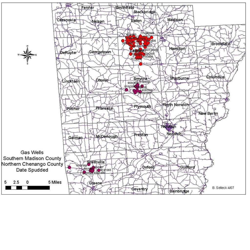
6 Gas exploration and development on private lands require that the landowner sell or lease mineral rights and access rights to their property. Landowners are strongly advised to consult a lawyer to review any contract before signing. Modern seismic exploration involves laying out a grid of geophones (earth sound sensors) which receive sound reflections from subsurface rock layers. The sound source may be an explosive device, or more commonly thumper trucks which use hydraulics and compressed air systems to bump the ground. The information from the geophone grid is then processed by high-speed computers to produce 2-D and 3-D cross-sections of subsurface structures. Advances in computer processing and software have made this sort of exploration more common over the last 15 years. Production was reported for 23 gas wells in Madison County in producing wells were located in the town of Lebanon; 4 in the town of Eaton.
 http://openlearn.open.ac.uk/file.")
7 The map on the left shows the proposed routes for Vibroseis exploration in the towns of Lebanon, Smyrna and Plymouth Typical Seismic Section (not from the Lebanon area)


8 Symonds Farm, Lebanon Road April 16, engineer/facts/99-029f3.gif White Eagle-1 Hill Road, Town of Eaton Drilling of a gas well requires construction of a drilling pad and access roads, and moving in and out of heavy equipment. Development of the well may involve installation of casing and cement sheath, and treatment of the producing formation to increase gas flow into the well. The above-ground equipment is not visually obtrusive; pipelines, valves and compressor facilities pose some safety risk. Properly designed and maintained wells do not offer significant environmental hazard.
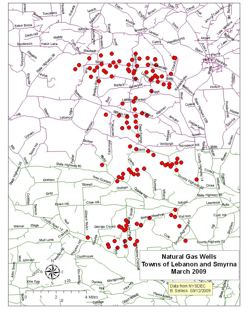
9 Gas wells in the Town of Lebanon Exploration and development of natural gas wells can have negative impacts on local infrastructure. Heavy drilling equipment may damage roads, culverts and bridges. Property owners should understand the legal framework of lease agreements and carefully document all exploration and development activity that takes place on their land. The Chenango County Farm Bureau has an informative website for property owners considering natural gas lease agreements. ( /issues/oil_lease/leasing2.htm)
10 Gas wells in the Town of Lebanon Landowners with producing gas wells may receive a proportion of the gas produced in addition to a royalty for the gas sold by the operator. Landowners near a producing well may be allocated some part of the royalty depending on proximity to the well and area of land owned within a defined spacing distance. Spacing is controlled by the characteristics of the reservoir unit, and is set legally by the NYS Department of Environmental Conservation (NYSDEC)
11
12 Gas Wells Drilled Town of Lebanon, Madison County Year 20 wells drilled in 2006 Bruce Selleck 4/5/ Number of Wells Spudded
13 $10.00 $9.00 $8.00 $7.00 $6.00 $5.00 $4.00 $3.00 $2.00 $1.00 $0.00 Average US January Wellhead Price of Natural Gas $8.66 $6.82 $5.21 $5.92 $4.43 $3.40 $2.60 $2.50 $2.23 $2.28 $2.23 $1.77 $1.74 $1.74 $1.62 $ Bruce Selleck 4/5/07
14 Natural Gas Production Madison County Town of Lebanon Year Bruce Selleck 1/09/09 MCF Natural Gas Produced
15 $1,600,000 $1,400,000 $1,200,000 $1,000,000 $800,000 $600,000 $400,000 $200,000 $0 Value of Production* *based on January of year average price U.S. Madison County Town of Lebanon Taxes Assessed Taxes Assessed = ~3.2% of production value $31,258 $34,878 $47, Well head value Bruce Selleck 10/25/07 Year
16 Year Madison County Production MCF Madison County Value Town Lebanon Production MCF Town Lebanon Value January wellhead gas price $105, $97,342 $ $169, $154,434 $ $317, $317,688 $ $451, $435,570 $ $1,405, $1,366,005 $ $718, $692,365 $ $1,063, $1,063,887 $ $1,390, $1,356,085 $ $1,396, $1,378,451 $ $2,115, $2,085,051 $8.66 Average household consumption of gas for domestic heating (only) in in the Northeastern US was 74.7 MCF (costing $1299 at a delivered price of $17.39 per MCF) (from The MCF produced in Madison County in 2006 would heat approximately 3,269 average households in the northeastern US; the delivered value of the gas produced was worth about $4,250,000.
17

 to assure reasonable formation pressure and")

18 Marcellus Shale Gas Potential Natural gas production in Madison County is almost entirely from the Oswego Sandstone- Herkimer Sandstone-Oneida Conglomerate interval. While there has been much speculation about the potential for natural gas development from the Marcellus Shale, the most likely areas for development are south of Madison County, where the Marcellus is at depths great enough (>1500 feet) to assure reasonable formation pressure and reservoir integrity. The map on the left shows areas in southern Madison and Chenango County where the Marcellus Shale unit lies at depths great enough (red color contours) for likely development. Areas with green contours have Marcellus Shale at depths less than 1500 feet. The Utica Shale, another potential shale gas target, underlies all of Madison and Chenango County. No Utica Shale gas has yet been developed in New York or adjacent areas.
 in Tioga County has been one of the most productive natural gas fields in the Appalachian Basin.")

19 Trenton-Black River reservoirs may exist at greater depths beneath the current levels of Oswego-Herkimer Sandstone exploration in Madison and Chenango Counties. The Glodes Corners Field (discovered in 1991) in Tioga County has been one of the most productive natural gas fields in the Appalachian Basin. These reservoirs occur at depths of 10,000 to 12,000 feet below the surface. Trenton-Black River reservoirs have not yet been discovered in Madison County, but may be present. A deep well drilled in the town of Stockbridge in 2005 tested a possible Trenton- Black River reservoir, but the flow of gas was not economic.
Natural Gas Development. Environmental Health and
 Environmental Health and Natural Gas Development Bruce Selleck Department of Geology Colgate University Hamilton, NY 13346 bselleck@mail.colgate.edu (map courtesy NYSDEC) Proterozoic (1.1 billion years
Geological Framework for Natural Gas Development in Central New York
 Geological Framework for Natural Gas Development in Central New York Natural Gas Development in Central New York Prepared by: Bruce Selleck Department of Geology Colgate University bselleck@mail.colgate.edu
Subsurface Geology and Resource Exploration
 LAB 11. Subsurface Geology and Resource Exploration Locating earth resources such as aluminum, copper, gold and gemstones has been an important job for geologists for a long time. This lab deals with the
Regents Earth Science
 Regents Earth Science Earth s History Name Section Rock Correlation Lab Lab# Introduction: The Cayuga Lake Basin contains one of the scenic Finger Lakes of central New York State. During the Devonian Period,
MESOZOIC BASINS. North Carolina Geological Survey
 MESOZOIC BASINS North Carolina Geological Survey The 1823 organic act which created the North Carolina Geological Survey (NCGS) tasked us to examine, describe and map the geology, geologic hazards, and
OIL AND GAS PLAYS OF THE MICHIGAN BASIN, SOUTHERN ONTARIO. Terry Carter, Consulting Geologist London, Ontario
 OIL AND GAS PLAYS OF THE MICHIGAN BASIN, SOUTHERN ONTARIO Terry Carter, Consulting Geologist London, Ontario 1 Ontario Petroleum Industries Oil and Natural Gas 1250 oil wells, 1200 gas wells, annual production
Structural Features and Fracture Orientation similarities between outcrops of the Ridgeley Sandstone
 The JUNIATA JOURNAL of GEOLOGY, 1, 1-8 (2014) Original article Structural Features and Fracture Orientation similarities between outcrops of the Ridgeley Sandstone Robert W. Baronner Two outcrops of the
C) use of nuclear power D) number of volcanic eruptions
 use of nuclear power D) number of volcanic eruptions") 3121-1 - Page 1 Name: 1) The graph below shows the change in carbon dioxide concentration in parts per million (ppm) in Earth's atmosphere from 1960 to 1990. The most likely cause of the overall change
3121-1 - Page 1 Name: 1) The graph below shows the change in carbon dioxide concentration in parts per million (ppm) in Earth's atmosphere from 1960 to 1990. The most likely cause of the overall change
Unconformities are depositional contacts that overlie rocks distinctly older than they are. They are often called gaps in the sedimentary record.
 UNCONFORMITIES Unconformities are depositional contacts that overlie rocks distinctly older than they are. They are often called gaps in the sedimentary record. The contact represents time when no sediment
ROCKS OF THE LAKE CAYUGA BASIN, NEW YORK
 Bedrock Correlation Name: Introduction: The Finger Lakes Region of New York State is underlain by rocks of Devonian Age. Use your reference tables to determine the types of rocks that outcrop around the
INTRODUCTION TABLE OF CONTENTS. Energy Symposium Master Drillers 8/12/2010. Shale Operations Charlie Scott 1. Operations in Pennsylvania & Shale Plays
 Operations in Pennsylvania & Shale Plays I. INTRODUCTION II. GENERAL DESCRIPTION OF A SHALE PLAY A. WHAT IS A SHALE PLAY B. WHERE ARE THEY C. WHAT MAKES THEM DIFFERENT III. MARCELLUS PLAY A. AREA B. HISTORY
Structural Geology of the Mountains
 Structural Geology of the Mountains Clinton R. Tippett Shell Canada Limited, Calgary, Alberta clinton.tippett@shell.ca INTRODUCTION The Southern Rocky Mountains of Canada (Figure 1) are made up of several
Seismic Data and Drilling in Hancock Co., Kentucky February 21, 2008
 Seismic Data and Drilling in Hancock Co., Kentucky February 21, 2008 J.A. Drahovzal 2/21/08 1 Hancock County (H1) Information Provided at 2/7/08 Meeting Depth of Top (t) and Thickness (th) in feet t Kn
Unconventional Natural Gas A Brief Review for Instituto Petroquimica Argentina
 October 5, 2010 Unconventional Natural Gas A Brief Review for Instituto Petroquimica Argentina William L. Tittle Principal and Director of Strategy Americas and Asia Raul Arias Alvarez Senior Consultant
PALEOGEOGRAPHY of NYS. Definitions GEOLOGIC PROCESSES. Faulting. Folding 9/6/2012. TOPOGRAPHIC RELIEF MAP of NYS GRADATIONAL TECTONIC
 TOPOGRAPHIC RELIEF MAP of NYS PALEOGEOGRAPHY of NYS Prof. Anthony Grande AFG 2012 Definitions GEOLOGIC PROCESSES Geography: study of people living on the surface of the earth. Geology: the scientific study
TOPOGRAPHIC RELIEF MAP of NYS. LANDFORMS of NYS. Landforms. Creation of NYS Landforms 9/22/2011
 TOPOGRAPHIC RELIEF MAP of NYS LANDFORMS of NYS Prof. Anthony Grande AFG 2011 Landforms The basis of present-day landforms (surface features) is the bedrock geology that has been worked on by the forces
Mineral activities within Rich County, Utah
 Natural Resources and Environmental Issues Volume 14 Bear Lake Basin Article 10 1-1-2007 Mineral activities within Rich County, Utah Patsy Palacios SJ & Jessie E Quinney Natural Resources Research Library,
1. Canadian Energy Use
 1 Unit 3 Energy 2 1. Canadian Energy Use Why are Canadians the sixth highest energy users in the world? Our major industries are energy intensive, overall industry consumes 31% of all energy in Canada.
Is It Likely That Fracking the Organic-Rich Utica Shale Beneath Bowling Green, OH Would Be Environmentally Safe?
 Is It Likely That Fracking the Organic-Rich Utica Shale Beneath Bowling Green, OH Would Be Environmentally Safe? Dr. Robert K. Vincent Prof. Emeritus, Dept. of Geology Bowling Green State University How
DETRITAL ZIRCON GEOCHRONOLOGY AND PROVENANCE OF MIDDLE AND UPPER DEVONIAN STRATA, NORTHERN APPALACHIAN BASIN OF NEW YORK STATE
 DETRITAL ZIRCON GEOCHRONOLOGY AND PROVENANCE OF MIDDLE AND UPPER DEVONIAN STRATA, NORTHERN APPALACHIAN BASIN OF NEW YORK STATE SELLECK, Bruce W. 1, CHIARENZELLI, Jeff 2, KRATZMANN, David J. 2, CHRISTOFFERSEN,
L.O: HOW GEOLOGISTS SEQUENCE EVENTS IN EARTH'S GEOLOGIC HISTORY IF NOT OVERTURNED, OLDEST ON BOTTOM, YOUNGEST ON TOP
 L.O: HOW GEOLOGISTS SEQUENCE EVENTS IN EARTH'S GEOLOGIC HISTORY IF NOT OVERTURNED, OLDEST ON BOTTOM, YOUNGEST ON TOP 1. Unless a series of sedimentary rock layers has been overturned, the bottom rock layer
Follow this and additional works at: Part of the Geology Commons
 Western Michigan University ScholarWorks at WMU Michigan Geological Repository for Research and Education Geosciences 2016 Geology of Michigan William B. Harrison III Michigan Geological Repository for
Fossils, Geologic Time, Absolute & Relative Dating, and Natural Resources. Chapters 5 & 6
 Fossils, Geologic Time, Absolute & Relative Dating, and Natural Resources Chapters 5 & 6 How Do Fossils Form? Fossils are found in sedimentary rocks like sandstone, limestone, and shale In Virginia, most
Michigan s Geology and Groundwater
 Michigan s Geology and Groundwater Ralph J. Haefner Deputy Director U.S. Geological Survey Michigan-Ohio Water Science Center Lansing, Michigan Outline About the USGS Geology 101 Michigan s geology Bedrock
Terrain Units PALEOGEOGRAPHY: LANDFORM CREATION. Present Geology of NYS. Detailed Geologic Map of NYS
 NYS TOPOGRAPHY Why so? PALEOGEOGRAPHY: LANDFORM CREATION Prof. Anthony Grande AFG 014 Present Geology of NYS Detailed Geologic Map of NYS Generalized Geology Detailed Geology Hot links to the fold out
The McCully gas field in southern New Brunswick was discovered in the year 2000 on a joint drilling exploration venture by Corridor Resources Inc.
 1 The McCully gas field in southern New Brunswick was discovered in the year 2000 on a joint drilling exploration venture by Corridor Resources Inc. and Potash Corporation of Saskatchewan. Located about
Kirkwood Gas Coalition Broome County New York Geologic Overview
 Kirkwood Gas Coalition Broome County New York Geologic Overview Zaengle Geoscience LLC Don Zaengle Geologist P.O. Box 242 14 Chase St. Worcester N.Y. 12197 Office: 607-397-8513 Cell: 607-434-3166 zaengledn@netscape.net
LANDFORMS of NYS. Landforms. Exercise 4 9/13/2012. TOPOGRAPHIC RELIEF MAP of NYS. Physiographic map of NYS and vicinity showing Surface Features
 TOPOGRAPHIC RELIEF MAP of NYS LANDFORMS of NYS Prof. Anthony Grande AFG 2012 Landforms REMINDER: The basis of present-day landforms (surface features) is the bedrock geology that has been worked on by
Name HW - Landscapes
 Name HW - Landscapes 1. New York s Tug Hill landscape region is classified as a plateau because this region has a A) high elevation with distorted bedrock B) high elevation with nearly horizontal layers
Module 10: Resources and Virginia Geology Topic 4 Content: Virginia Geology Notes
 Virginia is composed of a very diverse landscape that extends from the beaches and barrier islands all of the way to the highly elevated Appalachian Plateau. Geologists have discovered ancient shallow
Lines-of-Evidence Approach to the Evaluation of Stray Gas Incidents
 Lines-of-Evidence Approach to the Evaluation of Stray Gas Incidents Lisa Molofsky, Ann Smith, John Connor, Shahla Farhat GSI Environmental Inc. Tom Wagner, Albert Wylie Cabot Oil and Gas Corporation GSI
Running Head: Fracking Analysis in North Carolina 1 COST BENEFIT ANALYSIS OF FRACKING IN NORTH CAROLINA. Matthew B. Aupperle
 Running Head: Fracking Analysis in North Carolina 1 COST BENEFIT ANALYSIS OF FRACKING IN NORTH CAROLINA Matthew B. Aupperle Quantitative methods in Rocks and Minerals Steve Teeter Summer Ventures in Science
MUHAMMAD S TAMANNAI, DOUGLAS WINSTONE, IAN DEIGHTON & PETER CONN, TGS Nopec Geological Products and Services, London, United Kingdom
 Geological and Geophysical Evaluation of Offshore Morondava Frontier Basin based on Satellite Gravity, Well and regional 2D Seismic Data Interpretation MUHAMMAD S TAMANNAI, DOUGLAS WINSTONE, IAN DEIGHTON
Portion of the Grand Canyon
 Landscapes Packet 9 Your Name Group Members Score Minutes Standard 4 Key Idea 2 Performance Indicator 2.1 Use the concepts of density and heat energy to explain observations of weather patterns, seasonal
Tectonic Framework of New York State
 Tectonic Framework of New York State Kurt Hollocher Union College Geology Department Talk given for the UCALL program Union College, Schenectady, NY April 3, 2007 New York State Geological Highway Map.
Page 1. Name:
 Name: Questions 1 through 3 refer to the following: The diagrams below represent two rock outcrops found several miles apart in New York State. Individual rock layers are lettered, and fossils and rock
OVERVIEW OF THE ROGERSVILLE SHALE IN WEST VIRGINIA. Philip Dinterman West Virginia Geological & Economic Survey May 11, 2017
 OVERVIEW OF THE ROGERSVILLE SHALE IN WEST VIRGINIA Philip Dinterman West Virginia Geological & Economic Survey May 11, 2017 ACKNOWLEDGEMENT Dave Harris, John Hickman, Kentucky Geological Survey DATA NOTE
Outline 16: The Mesozoic World: Formation of Oil Deposits (with a side trip to the Devonian Marcellus Shale)
") Outline 16: The Mesozoic World: Formation of Oil Deposits (with a side trip to the Devonian Marcellus Shale) The first commercial oil well was drilled by Colonel Edwin Drake in Titusville, Pennsylvania,
Outline 16: The Mesozoic World: Formation of Oil Deposits (with a side trip to the Devonian Marcellus Shale) The first commercial oil well was drilled by Colonel Edwin Drake in Titusville, Pennsylvania,
State the principle of uniformitarianism. Explain how the law of superposition can be used to determine the relative age of rocks.
 Objectives State the principle of uniformitarianism. Explain how the law of superposition can be used to determine the relative age of rocks. Compare three types of unconformities. Apply the law of crosscutting
Plan of Development Mountain Valley Pipeline Project. APPENDIX P Plan for Unanticipated Discovery of Paleontological Resources
 APPENDIX P Plan for Unanticipated Discovery of Paleontological Resources Appendix P Plan for Unanticipated Discovery of Paleontological Resources Prepared by: TABLE OF CONTENTS 1.0 INTRODUCTION... 1 1.1
CARTER METALLURGICAL COAL PROJECT. Endurance Gold Corporation (EDG)
") CARTER METALLURGICAL COAL PROJECT McDOWELL COUNTY, WEST VIRGINIA Endurance Gold Corporation (EDG) Endurance Resources Inc. (ERI) Prepared by: Duncan McIvor, President and CEO Endurance Gold Corporation
CARTER METALLURGICAL COAL PROJECT McDOWELL COUNTY, WEST VIRGINIA Endurance Gold Corporation (EDG) Endurance Resources Inc. (ERI) Prepared by: Duncan McIvor, President and CEO Endurance Gold Corporation
THE MARCELLUS SHALE GAS PLAY Geology, Development, and Water-Resource Impact Mitigation
 THE MARCELLUS SHALE GAS PLAY Geology, Development, and Water-Resource Impact Mitigation John H. Williams New York Water Science Center Troy, New York https://profile.usgs.gov/jhwillia/ Marcellus shale
Drilling & Developing the Marcellus Shale
 Drilling & Developing the Marcellus Shale Presented by the Independent Oil and Gas Association of Pennsylvania at the Pennsylvania State Association of Township Supervisors Annual Meeting, May 12, 2008,
Unconventional Shale Gas & Conventional Opportunities in the Quebec Lowlands, Quebec Canada. Exploration Assets Management, LLC Wylie Texas 75098
 Unconventional Shale Gas & Conventional Opportunities in the Quebec Lowlands, Quebec Canada Exploration Assets Management, LLC Wylie Texas 75098 Jim Morabito 25 October, 2011 The Leap to Quebec Utica Shale
Analysis Of Light Hydrocarbons In Soil-Gases, Lost River Region West Virginia: Relation To Stratigraphy And Geological Structures.
 Analysis Of Light Hydrocarbons In Soil-Gases, Lost River Region West Virginia: Relation To Stratigraphy And Geological Structures. Harbert, W., Jones, V. T., Izzo, J, and Anderson, T. H. Department of
ENVI.2030L Geologic Time
 Name ENVI.2030L Geologic Time I. Introduction There are two types of geologic time, relative and absolute. In the case of relative time geologic events are arranged in their order of occurrence. No attempt
TIARO COAL JOINT VENTURE IRWIN RIVER COAL & COAL SEAM GAS QUEENSLAND TCJV AND WEST AUSTRALIAN COAL SEAM GAS PROJECT
 Suite 2, Mezanine Level, 35-37 Havelock Street WestPerth WA 6000 Telephone (08) 9481 8668 Facsimile: (08) 9322 7211 ASX ANNOUNCEMENT/MEDIA RELEASE 30th September 2008 TIARO COAL JOINT VENTURE IRWIN RIVER
SL GEOLOGY AND MINING. Coal bearing strata in the project area are referable primarily to the Allegheny Group of
 SL-145-1 GEOLOGY AND MINING Coal bearing strata in the project area are referable primarily to the Allegheny Group of Pennsylvania age. These rocks occur as dissected remnants overlying the ridge-forming
For personal use only
 Date: 18 February 2019 ASX Code: WEL Directors John Kopcheff Non-Executive Chairman Neville Henry Managing Director Peter Allchurch Non-Executive Director James Hodges Non-Executive Director Larry Liu
Petroleum geology framework, West Coast offshore region
 Petroleum geology framework, West Coast offshore region James W. Haggart* Geological Survey of Canada, Vancouver, BC jhaggart@nrcan.gc.ca James R. Dietrich Geological Survey of Canada, Calgary, AB and
Your web browser (Safari 7) is out of date. For more security, comfort and the best experience on this site: Update your browser Ignore
 is out of date. For more security, comfort and the best experience on this site: Update your browser Ignore") Your web browser (Safari 7) is out of date. For more security, comfort and the best experience on this site: Update your browser Ignore BEDRO CK For the complete encyclopedic entry with media resources,
Your web browser (Safari 7) is out of date. For more security, comfort and the best experience on this site: Update your browser Ignore BEDRO CK For the complete encyclopedic entry with media resources,
IVANHOE COMMENCES RESOURCE DELINEATION DRILLING AT NARIIN SUKHAIT COAL PROJECT IN MONGOLIA S SOUTH GOBI
 January 12, 2005 IVANHOE COMMENCES RESOURCE DELINEATION DRILLING AT NARIIN SUKHAIT COAL PROJECT IN MONGOLIA S SOUTH GOBI ULAANBAATAR, MONGOLIA Ivanhoe Mines Chairman Robert Friedland and President John
Continental Landscapes
 Continental Landscapes Landscape influenced by tectonics, climate & differential weathering Most landforms developed within the last 2 million years System moves toward an equilibrium Continental Landscapes
Potential for Shale Gas in Georgia:
 Potential for Shale Gas in Georgia: Preliminary Study for Feasibility Analysis of Shale Gas Exploration in Georgia Prepared for: AEAI under Grant Agreement #ECI GA R2 48 Georgia Energy Capacity Initiative
Tuesday 6 June 2017 Afternoon
 Oxford Cambridge and RSA Tuesday 6 June 2017 Afternoon A2 GCE GEOLOGY F794/01 Environmental Geology *6783378785* Candidates answer on the Question Paper. OCR supplied materials: None Other materials required:
28 th ROUND OF UK OFFSHORE LICENSING
 28 th ROUND OF UK OFFSHORE LICENSING RELINQUISHMENT REPORT LICENSE P2266 Block 47/6 Swift Exploration Ltd Stelinmatvic Industries Ltd April 2017 1 Location Licence P2266 Block 47/6 in the UK Southern Gas
GEOL 02: Historical Geology Lab 14: Topographic Maps. Name: Date:
 GEOL 02: Historical Geology Lab 14: Topographic Maps Name: Date: A topographic map is a two dimensional (flat) representation (model) of a three dimensional land surface (landscape). It shows landforms
Structural Geology Lab. The Objectives are to gain experience
 Geology 2 Structural Geology Lab The Objectives are to gain experience 1. Drawing cross sections from information given on geologic maps. 2. Recognizing folds and naming their parts on stereoscopic air
Tax ID = ac Athens Township, Bradford County, PA. Geologic Summary
 Tax ID =9-19-62 215ac Athens Township, Bradford County, PA Geologic Summary Zaengle Geoscience LLC Don Zaengle Geologist P.O. Box 242 14 Chase St. Worcester N.Y. 12197 DISCLAIMER Information on the subject
Evaluating Suitability of Appalachian Basin Reservoirs for NGLs Storage Jessica Moore, West Virginia Geological & Economic Survey
 1 THE APPALACHIAN STORAGE HUB STUDY: Evaluating Suitability of Appalachian Basin Reservoirs for NGLs Storage Jessica Moore, West Virginia Geological & Economic Survey 2 ASH STUDY OUR GOAL Complete a geologic
Cape Breton Island Mineral Inventory Studies: A Sandstone Quarry Development Opportunity at Graham River (NTS 11F/14), Inverness County
, Inverness County") Report of Activities 2001 23 Cape Breton Island Mineral Inventory Studies: A Sandstone Quarry Development Opportunity at Graham River (NTS 11F/14), Inverness County G. J. DeMont and J. E. Hawken Compilation
Report of Activities 2001 23 Cape Breton Island Mineral Inventory Studies: A Sandstone Quarry Development Opportunity at Graham River (NTS 11F/14), Inverness County G. J. DeMont and J. E. Hawken Compilation
Subsurface Geology of the Kennebec River
 Maine Geologic Facts and Localities July, 1998 Subsurface Geology of the Kennebec River 43 54 40.75 N, 69 48 29.01 W Text by Daniel B. Locke, Department of Agriculture, Conservation & Forestry 1 Map by
PHYSIOGRAPHIC REGIONS OF THE LOWER 48 UNITED STATES
 PHYSIOGRAPHIC REGIONS OF THE LOWER 48 UNITED STATES LAURENTIAN UPLAND 1. Superior Upland ATLANTIC PLAIN 2. Continental Shelf (not on map) 3. Coastal Plain a. Embayed section b. Sea Island section c. Floridian
1 of 5 12/10/2018, 2:38 PM
 1 of 5 12/10/2018, 2:38 PM The depth of the rock layer that serves as the disposal site for wastewater produced during unconventional oil extraction plays a significant role in whether that disposal triggers
Name: Date: Use the following to answer question 2.
 Name: Date: 1. Which of the following statements regarding the scientific method is false? A) A hypothesis must be agreed upon by more than one scientist. B) A theory is a hypothesis that has withstood
ALPHA GOLD PROJECT 1
 ALPHA GOLD PROJECT 1 Alpha Gold Project Over 1,000 acre property targeting the intersection of the 50 Moz Cortez Gold Trend and the regional scale Pine Valley Garden Valley anticline Anticlinal Crest preserved
The United States & Canada. A Regional Study of Anglo America
 A Regional Study of Anglo America Landform Regions of the United States & Canada world leaders in agricultural and industrial production because of... VAST LANDS stretch from the Atlantic Ocean on the
Devonian Petroleum Systems and Exploration Potential, Southern Alberta, Part 3 Core Conference
 Devonian Petroleum Systems and Exploration Potential, Southern Alberta, Part 3 Core Conference Andy Mort (1), Leonard Stevens (2), Richard Wierzbicki (2) Abstract Part 1: Devonian Petroleum Systems Dr.
PHYSICAL GEOGRAPHY: An overview. Definitions. Faulting. Folding GEOLOGIC PROCESSES 9/17/2013 TOPOGRAPHIC RELIEF
 TOPOGRAPHIC RELIEF PHYSICAL GEOGRAPHY: An overview Prof. Anthony Grande AFG 0913 2 Definitions GEOLOGIC PROCESSES Geography: Study of people living on the surface of the earth. Geology: the study of the
Geology 12 FINAL EXAM PREP. Possible Written Response Exam Questions
 Geology 12 FINAL EXAM PREP Possible Written Response Exam Questions Use this study guide to prepare for the written response portion of the final exam. Name FINAL EXAM - POSSIBLE WRITTEN RESPONSE QUESTIONS
Unconventional Reservoir Development: The Role of Geoscience from a State Regulator s Perspective
 Unconventional Reservoir Development: The Role of Geoscience from a State Regulator s Perspective Nick Tew Alabama State Geologist and Oil and Gas Supervisor President, American Geosciences Institute Geological
Presentation to the NATIONAL BUYER / SELLER FORUM March 24, Brad J. Hayes Petrel Robertson Consulting Ltd.
 Presentation to the NATIONAL BUYER / SELLER FORUM March 24, 2010 Brad J. Hayes Petrel Robertson Consulting Ltd. Canada s Gas Resources the Picture in 2010 This gas resource picture is only a snapshot because
Geography 3202 Unit 4 S.C.O. 4.3 & 4.5. Primary Resource Activities Offshore Oil And Gas
 Geography 3202 Unit 4 S.C.O. 4.3 & 4.5 Primary Resource Activities Offshore Oil And Gas Factors Affecting The Decision To Recover Offshore Oil And Gas (4.3.1) Physical Factors 1. Ocean Related Factors
For personal use only
 Vail Project Primer Contact: Tim Hoops Managing Director tim.hoops@strata-x.com www.strata-x.com Why is Strata-X drilling in Illinois? Illinois is a Proven and Mature Oil Provence Production dates back
Exploring Eastern Africa. East Africa Oil and Gas Summit, 2014 March 2014
 Exploring Eastern Africa East Africa Oil and Gas Summit, 2014 March 2014 1 Exploring Eastern Africa Who is Rift Energy? Why East Africa? History of an exploration asset: Block L19 Kenya Growing the portfolio
The Nubian Sandstone Aquifer System. Martina Müller Claudia Dengler Felix Leicht
 The Nubian Sandstone Aquifer System Martina Müller Claudia Dengler Felix Leicht Geography Transboundary groundwater system beneath the north-eastern Sahara total extension of over 2.2 Mio km² Shared between
Petroleum Systems (Part One) Source, Generation, and Migration
 Source, Generation, and Migration") Petroleum Systems (Part One) Source, Generation, and Migration GEOL 4233 Class January 2008 Petroleum Systems Elements Source Rock Migration Route Reservoir Rock Seal Rock Trap Processes Generation Migration
Petroleum Systems (Part One) Source, Generation, and Migration GEOL 4233 Class January 2008 Petroleum Systems Elements Source Rock Migration Route Reservoir Rock Seal Rock Trap Processes Generation Migration
Risk Evaluation. Todd Shipman PhD, Alberta Geological Survey/Alberta Energy Regulator November 17 th,2017 Induced Seismicity Workshop, Yellowknife NWT
 Risk Evaluation Todd Shipman PhD, Alberta Geological Survey/Alberta Energy Regulator November 17 th,2017 Induced Seismicity Workshop, Yellowknife NWT Risk Management Approach to Induced Seismicity Establishing
Western Kentucky CO 2 Storage Test
 Western Kentucky CO 2 Storage Test Principal Investigators: Rick Bowersox - Lexington Dave Williams - Henderson KGS First Friday Seminar Lexington, Kentucky March 4, 2011 The project proceeded in two phases:
THIS IS A NEW SPECIFICATION
 THIS IS A NEW SPECIFICATION ADVANCED GCE GEOLOGY Environmental Geology F794 * OCE / 12441* Candidates answer on the Question Paper OCR Supplied Materials: None Other Materials Required: Electronic calculator
Black Road, Tax ID = , 22.7 ac Wilmot Township, Bradford County, PA. Geologic Summary
 Black Road, Tax ID = 58-127-66, 22.7 ac Wilmot Township, Bradford County, PA Geologic Summary Zaengle Geoscience LLC Don Zaengle Geologist P.O. Box 242 14 Chase St. Worcester N.Y. 12197 DISCLAIMER Information
ENGINEER S CERTIFICATION OF FAULT AREA DEMONSTRATION (40 CFR )
") PLATTE RIVER POWER AUTHORITY RAWHIDE ENERGY STATION BOTTOM ASH TRANSFER (BAT) IMPOUNDMENTS LARIMER COUNTY, CO ENGINEER S CERTIFICATION OF FAULT AREA DEMONSTRATION (40 CFR 257.62) FOR COAL COMBUSTION RESIDUALS
PLATTE RIVER POWER AUTHORITY RAWHIDE ENERGY STATION BOTTOM ASH TRANSFER (BAT) IMPOUNDMENTS LARIMER COUNTY, CO ENGINEER S CERTIFICATION OF FAULT AREA DEMONSTRATION (40 CFR 257.62) FOR COAL COMBUSTION RESIDUALS
Introduction Geology
 Introduction The Wild Horse Anticline is located in the prolific Bighorn Basin of Wyoming about 5 miles northeast of the town of Basin. This structure demonstrates excellent fourway closure encompassing
Geologic Resources. Geologic Resources and Society. Geologic Resources and Society
 Geologic Resources Our entire society rests upon - and is dependent upon - our water, our land, our forests, and our minerals. How we use these resources influences our health, security, economy, and well-being.
CENTRAL UTAH: A NEW OIL AND GAS PROVINCE
 CENTRAL UTAH: A NEW OIL AND GAS PROVINCE By Floyd and Mike By: Floyd Moulton and Mike Pinnell Wolverine Discovery Eastern Limit of Thrusting Presentation Outline Regional Setting Paleozoic Source Rock
Section 7. Reading the Geologic History of Your Community. What Do You See? Think About It. Investigate. Learning Outcomes
 Chapter 3 Minerals, Rocks, and Structures Section 7 Reading the Geologic History of Your Community What Do You See? Learning Outcomes In this section, you will Goals Text Learning Outcomes In this section,
An Analytic Approach to Sweetspot Mapping in the Eagle Ford Unconventional Play
 An Analytic Approach to Sweetspot Mapping in the Eagle Ford Unconventional Play Murray Roth*, Transform Software and Services, Denver, Colorado, Murray@transformsw.com Michael Roth, Transform Software
For Sale - 56 Acre Sandstone Quarry State Route 511, Oberlin/Kipton, OH 44075
 14647 State Route 511, Oberlin/Kipton, OH 44075 56 ACRES Vermilion Rd Gifford Rd Haigh Rd 44 Summary The Kipton sandstone quarry is included in 56 acre tract owned by Terry A. Johnson, of Huron, Ohio.
3/5/05 Dr. Stewart 1
 I. Physiography of Appalachian Mountains A. Introduction 1. These mountains extend from NE Canada to Georgia 2. They are the remains of a deeply eroded, ancient mountain chain once larger than the Himalayans
GEOLOGICAL TIME / DATING TECHNIQUES
 DATE DUE: INSTRUCTOR: TERRY J. BOROUGHS Geology 305 NAME: SECTION: GEOLOGICAL TIME / DATING TECHNIQUES Instructions: Read each question carefully before selecting the BEST answer. Provide specific and
Lab 9: Petroleum and groundwater
 Geology 101 Name(s): Lab 9: Petroleum and groundwater Petroleum (oil) is a multi-component liquid refined to generate different hydrocarbons, such as heptane (a component of gasoline) and waxes. For the
AGENDA HIGHT LIGHT OF INDONESIA EXPLORATION ACTIVITY BACKGROUND
 AGENDA Background - Hight Light of Indonesia Exploration Activity - Obstacles - Exploration Opportunity - Exploration Strategy Definition - Exploration Incentives - New Field NELLI EKAYANTI New Field Determining
September 28, Michael James Murphy PROPOSAL FOR DECISION PROCEDURAL HISTORY
 September 28, 2007 Rule 37 Case No. 86316 APPLICATION OF EARTH SCIENCE EXPLORATION, INC. TO CONSIDER AN EXCEPTION TO STATEWIDE RULE 37 FOR THE JACKSON LEASE, WELL NO. 1A, CATTAIL HOLLOW (CONGL.), SMYRNA
=%REPORT RECONNAISSANCE OF CHISHOLM LAKE PROSPECT. October 25, 1977
 =%REPORT ON FIELD RECONNAISSANCE OF CHISHOLM LAKE PROSPECT October 25, 1977 Bruce D. Vincent Imperial Oil Limited, Minerals - Coal, CALGARY, ALBERTA CHISHOLM LAKE PROSPECT Introduction The Chisholm Lake
5. Compare the density of the oceanic crust to continental crust. 6. What kind of plate boundary is this? convergent
 The youngest rock is in the middle (at ridge) and it gets older on either side as you move away in a symmetrical pattern. 1. How does the age of the seafloor compare on either side of the ridge? A = youngest
CHAPTER 7 GEOLOGY AND SOILS
 CHAPTER 7 GEOLOGY AND SOILS 7.1 General Geology of the Area Based on the Geological map compiled by Cornec (2002) the area consists of Miocene/Pleistocene deposits as seen in figure 7.1. These are geologically
Petroleum Potential of the Application Area L12-4
 Petroleum Potential of the Application Area L12-4 The Application Area (L12-4) is underlain by the western Officer Basin, beneath the Gunbarrel Basin. The general basin architecture is outlined in Figure
A Review of Three North American Shale Plays: Learnings from Shale Gas Exploration in the Americas*
 A Review of Three North American Shale Plays: Learnings from Shale Gas Exploration in the Americas* David Waldo 1 Search and Discovery Article #80214 (2012)** Posted May 28, 2012 *Adapted from oral presentation
Sequence Stratigraphy of the Upper Cretaceous Niobrara Formation, A Bench, Wattenberg Field, Denver Julesburg Basin, Colorado*
 Sequence Stratigraphy of the Upper Cretaceous Niobrara Formation, A Bench, Wattenberg Field, Denver Julesburg Basin, Colorado* Lisa E. Remington LaChance 1 and Mark C. Robinson 1 Search and Discovery Article
Western Kentucky Deep Saline Reservoir CO 2 Storage Test. Principal Investigators: J. Richard Bowersox - Lexington David A. Williams - Henderson
 Western Kentucky Deep Saline Reservoir CO 2 Storage Test Principal Investigators: J. Richard Bowersox - Lexington David A. Williams - Henderson August 12, 2008 Electric power generating and industrial