Geological Framework for Natural Gas Development in Central New York
|
|
|
- Alfred Marshall Summers
- 6 years ago
- Views:
Transcription

1 Geological Framework for Natural Gas Development in Central New York
2 Natural Gas Development in Central New York Prepared by: Bruce Selleck Department of Geology Colgate University Natural gas is a fossil fuel that is derived from ancient, buried organic matter. Natural gas is a mixture of methane, ethane, propane and butane, and is found in many sedimentary rocks. For the gas to be extracted in commercially viable amounts a natural reservoir system is required. This presentation focuses on the natural gas developments in Central New York, with special emphasis on new reservoir systems that are being tapped. The application of horizontal drilling, and potentially, hydrofracturing technologies, in shale gas reservoirs has opened potential development in areas that have previously seen little or no activity. This presentation includes some information regarding environmental concerns related to oil and gas development. A more detailed analysis of these issues can be found at


3


4 New England Appalachian Mountains Adirondack Mountains Appalachian Basin Lake Ontario Lake Erie
 Trenton-B.R. This map depicts the distribution of gas and oil fields in New York State in 1980.")

5 Gas and Oil Fields in Central and Western New York circa Marcellus? Herkimer Utica? (NYSERDA) Trenton-B.R. This map depicts the distribution of gas and oil fields in New York State in Virtually all of the historical development has been in the western part of the state. No oil has been recovered from wells east of the Finger Lakes region, but there is considerable potential for natural gas. All of the oil and gas in New York is found in Paleozoic sedimentary rocks which were deposited from 520 to 300 million years ago. Most of these rocks were laid down in a sedimentary basin - the Appalachian Basin that stretched across eastern north America from Nova Scotia to Alabama.
6 What is natural gas? Hydrocarbons are C-H compounds with C-H and C-C bonds. Breaking of these bonds by oxidation (combustion) releases heat energy Most common petroleum and gas hydrocarbons are alkanes, with the general formula - C n H 2n+2 Natural gas has the lowest carbon footprint of any fossil fuel and is made up mostly of methane - - CH 4, with some ethane C 2 H 6, propane - C 3 H 8 and butane - C 4 H 10 Heavier alkanes - pentane, hexane, heptane, octane, etc - are liquid at surface temperatures and pressures Liquid petroleum is a mixture of C 5 to C 30 alkanes, plus aromatics (e.g. benzene) and alkenes Methane is also produced by a variety of biological processes at the earth s surface methane from surface biological systems is rarely accompanied by ethane, propane or butane methane from biological systems can be distinguished from natural gas (petroleum system) methane using carbon and hydrogen stable isotope fingerprinting Petroleum system natural gas is usually associated with minor liquid hydrocarbons (wet gas with condensate) Dry gas systems are most common in sedimentary rocks that have been heated above 140ºC Brine (formation water) is produced from most natural gas wells and must be safely disposed of


7
8 organic matter 20 o C H:C ratio carbon dioxide evolved (decarboxlyation) methane evolved km buried 1.0 kerogen 60 o C 2.0 petroleum liquids 90 o C 120 o C asphalt, bitumen 200 o C Where does it come from? 5.0
9 Summary of Natural Gas Production in NYS and Chenango County 2008 (DEC Data) The most common unit of measure for natural gas is the MCF 1 MCF = 1000 cubic feet of gas at surface temperature and pressure. This is approximately equal to 1,000,000 BTU 1 Therm = 100,000 BTU MCF is approximately 1000 Therm A typical residence in the NE US would consume ~73 MCF for domestic heating in one year In 2008: NYS consumed 1,190,341,000 MCF of natural gas NYS produced 50,320,077 MCF of natural gas = 4.2% of consumption 7790 natural gas wells in NY had production reported the top 100 producing wells accounted for 70% of the states production 76 of the top 100 wells produced gas from the Trenton-Black River reservoir system other producing formations in the top 100 Theresa (5 wells); Oneida (5); Herkimer (4) Chenango County in 2008: 427,609 MCF (=~ $3,000,000 at January 2008 wellhead price of $6.99/MCF) 18 wells top producer at ~95,000 MCF is a Herkimer well

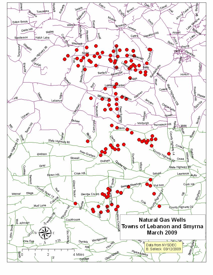
10 Subsurface exploration prior to drilling depends on seismic data. Modern seismic exploration technology allows developers to precisely target the highest-quality portions of reservoir formations. Grids of seismic data are used to construct 3-D subsurface seismic sections. The map on the left shows routes for Vibroseis exploration in the towns of Lebanon, Smyrna and Plymouth 2-D Seismic section (not from the Lebanon area)
 and a lithologic")

11 Well logs are prepared during and immediately after drilling. The log may consist of a number of remotely sensed parameters (density, gamma ray, neutron) and a lithologic log prepared from well cuttings or, more rarely, from cores. Well logs are used to characterize reservoirs, determine the geometry of pay zones and direct further exploration and development. Well log data and well cuttings are available from the New York State Museum.


12 White Eagle-1 Hill Road, Town of Eaton Drilling of a gas well requires construction of a drilling pad and access roads, and moving in and out of heavy equipment. Development of the well may involve installation of casing and cement sheath, and treatment of the producing formation to increase gas flow into the well. The above-ground equipment is not visually obtrusive; pipelines, valves and compressor facilities pose some safety risk. Properly designed and maintained wells do not offer significant environmental hazard. Symonds Farm, Lebanon Road April 16, engineer/facts/99-029f3.gif
13 Rock strata in central New York dip gently to the southwest. This cross-section exaggerates the dip and shows the sedimentary units and their ages. The oldest rocks in New York are the 1.1 billion year old metamorphic and igneous rocks of the Adirondacks. These ancient rocks contain no oil or gas, but host deposits of metals ores for iron, titanium, lead and zinc, and useful minerals like talc, wollastonite and garnet. The red pattern indicates rock units that may serve as reservoir beds in central and western New York. SW Appalachian Plateau West Falls Group Genesee Group Oriskany SS Hamilton Group Onondaga Limestone Herkimer SS Helderberg Group Oswego SS Syracuse Fm Utica Shale Devonian Oneida Fm Theresa Formation Potsdam Sandstone Silurian Black River and Trenton Groups Mohawk Valley Ordovician NE Adirondacks Proterozoic (1.1 billion years old) Grenville Province Basement Bruce Selleck 4/5/07
14 Utica Shale Outcrop Belt


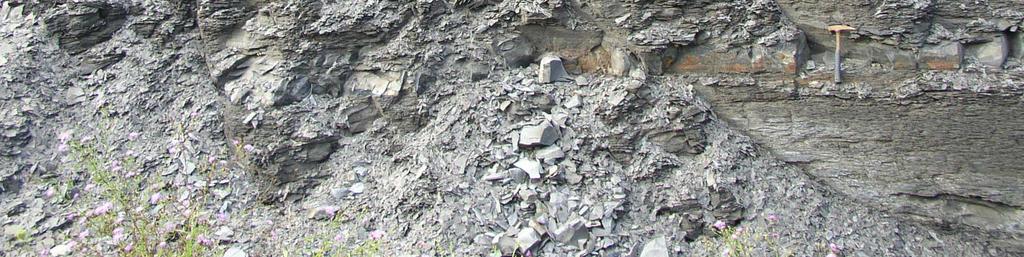
15 Utica Shale outcrop near Vanhornesville,, NY 2 meters
16 Utica Shale Gas Potential Subsurface Utica Shale at reasonable reservoir depths Utica Shale high probability fairway
17 Herkimer Sandstone Outcrop Belt


18 Herkimer Sandstone outcrop near Jordanville,, NY
19 Herkimer Sandstone Potential Potential Herkimer Sandstone fairway
20

21 Most gas wells in Chenango County tap reservoirs in the Oswego/Oneida/Herkimer sandstones. The Utica Shale that underlies the sandstone may be source bed for the gas. Minor fold structures in the sandstone help to trap the gas in commercial quantities. Wells in the Town of Smyrna are developed in a minor fold structure where the sandstone is unusually thick. The overlying Ilion Shale forms a seal on the reservoir sandstone. Wells are typically deep. Deeper wells (greater than 10,000 feet) in the eastern Finger Lakes region have encountered large reservoirs in the Trenton-Black River Group trend. Trenton-Black River discoveries are related to deep fault structures and have proven difficult to locate, but very profitable when exploited. Genesee Group Hamilton Group Oriskany Sandstone Onondaga Limestone Helderberg Group Oriskany Sandstone Cobleskill Limestone Syracuse Formation Vernon Shale Herkimer Sandstone Oswego gas Ilion Shale Oneida Conglomerate Sandstone Utica Shale pinch-out of Oswego Sandstone Schematic model of the Bradley Brook Natural Gas Field Bruce Selleck 4/5/07
22 Horizontal Well in Herkimer Sandstone Town of Lebanon, Madison County Marcellus Onondaga Depth in Feet Helderberg Camillus Oriskany Syracuse Vernon Herkimer Herkimer SS Lockport Willowvale
23 Marcellus Shale Outcrop Belt


24 Marcellus Shale outcrop near Chittenango, NY 2 meters
25 Subsurface Marcellus Shale at reasonable reservoir depths. Marcellus Shale Gas Potential Marcellus Shale high probability fairway


 for likely")

26 Marcellus Shale Gas Potential Natural gas production in Chenango County is almost entirely from the Oswego Sandstone- Herkimer Sandstone-Oneida Conglomerate interval. While there has been much speculation about the potential for natural gas development from the Marcellus Shale, the most likely areas for development are where the Marcellus is at depths great enough (>1500 feet) to assure reasonable formation pressure and reservoir integrity. The map on the left shows areas in southern Madison and Chenango County where the Marcellus Shale unit lies at depths great enough (red color contours) for likely development. Areas with green contours have Marcellus Shale at depths less than 1500 feet. The Utica Shale, another potential shale gas target, underlies all of Madison and Chenango County. The Utica Shale potential may exceed that of the Marcellus in Chenango County.
 Grenville Province Basement Genesee Group SW NE Devonian Ordovician Silurian Oneida Conglomerate Black River and Trenton Groups Potsdam Sandstone Theresa Formation Syracuse Fm")
27 Proterozoic (1.1 billion years old) Grenville Province Basement Genesee Group SW NE Devonian Ordovician Silurian Oneida Conglomerate Black River and Trenton Groups Potsdam Sandstone Theresa Formation Syracuse Fm Oswego SS Hamilton Group Onondaga Limestone Herkimer SS Appalachian Plateau. Cross-section illustrates the schematic subsurface distribution of the Utica Shale, Herkimer Sandstone and Marcellus Shale. Mohawk Valley Bruce Selleck 8/18/09 Adirondacks Marcellus Shale Helderberg Group Utica Shale West Falls Group Oriskany SS
28 Utica, Herkimer and Marcellus high probability fairways

29 Fault structures may strongly influence the distribution of some gas reservoirs. Naturally fractured reservoir rocks are sometimes associated with surface lineaments defined by stream valleys or other aligned topographic features. Faults also guide the hydrothermal fluids that lead to Trenton- Black River dolomite reservoirs. However, faults may also cause leakage of gas out of reservoirs.
 in Tioga County has been one of the most productive natural gas fields in the Appalachian Basin.")

30 Trenton-Black River reservoirs may exist at greater depths beneath the current levels of Oswego-Herkimer Sandstone exploration in Madison and Chenango Counties. The Glodes Corners Field (discovered in 1991) in Tioga County has been one of the most productive natural gas fields in the Appalachian Basin. These reservoirs occur at depths of 10,000 to 12,000 feet below the surface. Trenton-Black River reservoirs have not yet been discovered in Chenango County, but may be present. A deep well drilled in 2005 in the town of Stockbridge, Madison County tested a possible Trenton-Black River reservoir, but the flow of gas was not economic

31 Very ancient basement fault patterns may influence regional distribution of natural gas reservoirs.
32 What s next? NYSDEC will issue Marcellus and Utica Shale GEIS guidelines in early Expect legal challenges to the guidelines. Resolution may not occur until late 2010 Leasing and drilling activity will continue to be slow through most of 2010 Successful horizontal development in Herkimer may attract other players New federal statues regulating shale gas development are unlikely US EPA may play a larger role in water quality monitoring in shale gas development areas Companies will continue to search for elusive new Trenton-Black River fields. Utica Shale tests, using vertical wells, will continue Land coalitions will play a larger role in leasing activity, but will be fragile and subject to cherry-picking Local governments, especially at the township level, must be informed and prepared

33
in Madison County, New York Natural Gas Development
 Natural Gas Development in Madison County, New York Bruce Selleck Department of Geology Colgate University Hamilton, NY 13346 bselleck@mail.colgate.edu Natural Gas Development in Madison County, New York
Natural Gas Development. Environmental Health and
 Environmental Health and Natural Gas Development Bruce Selleck Department of Geology Colgate University Hamilton, NY 13346 bselleck@mail.colgate.edu (map courtesy NYSDEC) Proterozoic (1.1 billion years
OIL AND GAS PLAYS OF THE MICHIGAN BASIN, SOUTHERN ONTARIO. Terry Carter, Consulting Geologist London, Ontario
 OIL AND GAS PLAYS OF THE MICHIGAN BASIN, SOUTHERN ONTARIO Terry Carter, Consulting Geologist London, Ontario 1 Ontario Petroleum Industries Oil and Natural Gas 1250 oil wells, 1200 gas wells, annual production
C) use of nuclear power D) number of volcanic eruptions
 use of nuclear power D) number of volcanic eruptions") 3121-1 - Page 1 Name: 1) The graph below shows the change in carbon dioxide concentration in parts per million (ppm) in Earth's atmosphere from 1960 to 1990. The most likely cause of the overall change
3121-1 - Page 1 Name: 1) The graph below shows the change in carbon dioxide concentration in parts per million (ppm) in Earth's atmosphere from 1960 to 1990. The most likely cause of the overall change
Kirkwood Gas Coalition Broome County New York Geologic Overview
 Kirkwood Gas Coalition Broome County New York Geologic Overview Zaengle Geoscience LLC Don Zaengle Geologist P.O. Box 242 14 Chase St. Worcester N.Y. 12197 Office: 607-397-8513 Cell: 607-434-3166 zaengledn@netscape.net
1. Canadian Energy Use
 1 Unit 3 Energy 2 1. Canadian Energy Use Why are Canadians the sixth highest energy users in the world? Our major industries are energy intensive, overall industry consumes 31% of all energy in Canada.
Name HW - Landscapes
 Name HW - Landscapes 1. New York s Tug Hill landscape region is classified as a plateau because this region has a A) high elevation with distorted bedrock B) high elevation with nearly horizontal layers
Regents Earth Science
 Regents Earth Science Earth s History Name Section Rock Correlation Lab Lab# Introduction: The Cayuga Lake Basin contains one of the scenic Finger Lakes of central New York State. During the Devonian Period,
Structural Features and Fracture Orientation similarities between outcrops of the Ridgeley Sandstone
 The JUNIATA JOURNAL of GEOLOGY, 1, 1-8 (2014) Original article Structural Features and Fracture Orientation similarities between outcrops of the Ridgeley Sandstone Robert W. Baronner Two outcrops of the
Outline 16: The Mesozoic World: Formation of Oil Deposits (with a side trip to the Devonian Marcellus Shale)
") Outline 16: The Mesozoic World: Formation of Oil Deposits (with a side trip to the Devonian Marcellus Shale) The first commercial oil well was drilled by Colonel Edwin Drake in Titusville, Pennsylvania,
Outline 16: The Mesozoic World: Formation of Oil Deposits (with a side trip to the Devonian Marcellus Shale) The first commercial oil well was drilled by Colonel Edwin Drake in Titusville, Pennsylvania,
Subsurface Geology and Resource Exploration
 LAB 11. Subsurface Geology and Resource Exploration Locating earth resources such as aluminum, copper, gold and gemstones has been an important job for geologists for a long time. This lab deals with the
TOPOGRAPHIC RELIEF MAP of NYS. LANDFORMS of NYS. Landforms. Creation of NYS Landforms 9/22/2011
 TOPOGRAPHIC RELIEF MAP of NYS LANDFORMS of NYS Prof. Anthony Grande AFG 2011 Landforms The basis of present-day landforms (surface features) is the bedrock geology that has been worked on by the forces
MESOZOIC BASINS. North Carolina Geological Survey
 MESOZOIC BASINS North Carolina Geological Survey The 1823 organic act which created the North Carolina Geological Survey (NCGS) tasked us to examine, describe and map the geology, geologic hazards, and
L.O: HOW GEOLOGISTS SEQUENCE EVENTS IN EARTH'S GEOLOGIC HISTORY IF NOT OVERTURNED, OLDEST ON BOTTOM, YOUNGEST ON TOP
 L.O: HOW GEOLOGISTS SEQUENCE EVENTS IN EARTH'S GEOLOGIC HISTORY IF NOT OVERTURNED, OLDEST ON BOTTOM, YOUNGEST ON TOP 1. Unless a series of sedimentary rock layers has been overturned, the bottom rock layer
Terrain Units PALEOGEOGRAPHY: LANDFORM CREATION. Present Geology of NYS. Detailed Geologic Map of NYS
 NYS TOPOGRAPHY Why so? PALEOGEOGRAPHY: LANDFORM CREATION Prof. Anthony Grande AFG 014 Present Geology of NYS Detailed Geologic Map of NYS Generalized Geology Detailed Geology Hot links to the fold out
Structural Geology of the Mountains
 Structural Geology of the Mountains Clinton R. Tippett Shell Canada Limited, Calgary, Alberta clinton.tippett@shell.ca INTRODUCTION The Southern Rocky Mountains of Canada (Figure 1) are made up of several
Follow this and additional works at: Part of the Geology Commons
 Western Michigan University ScholarWorks at WMU Michigan Geological Repository for Research and Education Geosciences 2016 Geology of Michigan William B. Harrison III Michigan Geological Repository for
Ministry of Oil and Minerals Petroleum Exploration & Production Authority BLOCK 80 (WADI SARR)
") Ministry of Oil and Minerals Petroleum Exploration & Production Authority BLOCK 80 (WADI SARR) The Wadi Sarr Block (80) occupies an area of 1961 km 2 on the Sayun- Masilah Basin in the central Yemen. Block
Ministry of Oil and Minerals Petroleum Exploration & Production Authority BLOCK 80 (WADI SARR) The Wadi Sarr Block (80) occupies an area of 1961 km 2 on the Sayun- Masilah Basin in the central Yemen. Block
Is It Likely That Fracking the Organic-Rich Utica Shale Beneath Bowling Green, OH Would Be Environmentally Safe?
 Is It Likely That Fracking the Organic-Rich Utica Shale Beneath Bowling Green, OH Would Be Environmentally Safe? Dr. Robert K. Vincent Prof. Emeritus, Dept. of Geology Bowling Green State University How
Update on Trenton Black River Playbook Study-New York State Museum
 Update on Trenton Black River Playbook Study-New York State Museum Taury Smith, Rich Nyahay, Rick Bray, Courtney Lugert, Rose Schulze and Brian Slater New York State Museum Task 4: Geochemistry Task 1
Unconformities are depositional contacts that overlie rocks distinctly older than they are. They are often called gaps in the sedimentary record.
 UNCONFORMITIES Unconformities are depositional contacts that overlie rocks distinctly older than they are. They are often called gaps in the sedimentary record. The contact represents time when no sediment
Fossils, Geologic Time, Absolute & Relative Dating, and Natural Resources. Chapters 5 & 6
 Fossils, Geologic Time, Absolute & Relative Dating, and Natural Resources Chapters 5 & 6 How Do Fossils Form? Fossils are found in sedimentary rocks like sandstone, limestone, and shale In Virginia, most
Portion of the Grand Canyon
 Landscapes Packet 9 Your Name Group Members Score Minutes Standard 4 Key Idea 2 Performance Indicator 2.1 Use the concepts of density and heat energy to explain observations of weather patterns, seasonal
Analysis Of Light Hydrocarbons In Soil-Gases, Lost River Region West Virginia: Relation To Stratigraphy And Geological Structures.
 Analysis Of Light Hydrocarbons In Soil-Gases, Lost River Region West Virginia: Relation To Stratigraphy And Geological Structures. Harbert, W., Jones, V. T., Izzo, J, and Anderson, T. H. Department of
Michigan s Geology and Groundwater
 Michigan s Geology and Groundwater Ralph J. Haefner Deputy Director U.S. Geological Survey Michigan-Ohio Water Science Center Lansing, Michigan Outline About the USGS Geology 101 Michigan s geology Bedrock
Mineral activities within Rich County, Utah
 Natural Resources and Environmental Issues Volume 14 Bear Lake Basin Article 10 1-1-2007 Mineral activities within Rich County, Utah Patsy Palacios SJ & Jessie E Quinney Natural Resources Research Library,
Plan of Development Mountain Valley Pipeline Project. APPENDIX P Plan for Unanticipated Discovery of Paleontological Resources
 APPENDIX P Plan for Unanticipated Discovery of Paleontological Resources Appendix P Plan for Unanticipated Discovery of Paleontological Resources Prepared by: TABLE OF CONTENTS 1.0 INTRODUCTION... 1 1.1
Petroleum Systems (Part One) Source, Generation, and Migration
 Source, Generation, and Migration") Petroleum Systems (Part One) Source, Generation, and Migration GEOL 4233 Class January 2008 Petroleum Systems Elements Source Rock Migration Route Reservoir Rock Seal Rock Trap Processes Generation Migration
Petroleum Systems (Part One) Source, Generation, and Migration GEOL 4233 Class January 2008 Petroleum Systems Elements Source Rock Migration Route Reservoir Rock Seal Rock Trap Processes Generation Migration
MIDDLE DEVONIAN PLAY MICHIGAN BASIN OF ONTARIO. Duncan Hamilton
 MIDDLE DEVONIAN PLAY MICHIGAN BASIN OF ONTARIO Duncan Hamilton 1 Middle Devonian Pools of the Michigan Basin 375+ Million Barrels Michigan 45+ million Barrels Ontario 2 Outline of Presentation History
Geol Supplementary Notes 463-RWR-1,2 GEOL RWR-1 GENERAL INTRODUCTION TO PETROLEUM GEOLOGY: OUTLINE OF MATERIAL TO BE COVERED
 GEOL 463.3 RWR-1 GENERAL INTRODUCTION TO PETROLEUM GEOLOGY: OUTLINE OF MATERIAL TO BE COVERED Recommended sections to read in the textbook: Chapters 1 and 2 (p. 2-22): Background to development of petroleum
LANDFORMS of NYS. Landforms. Exercise 4 9/13/2012. TOPOGRAPHIC RELIEF MAP of NYS. Physiographic map of NYS and vicinity showing Surface Features
 TOPOGRAPHIC RELIEF MAP of NYS LANDFORMS of NYS Prof. Anthony Grande AFG 2012 Landforms REMINDER: The basis of present-day landforms (surface features) is the bedrock geology that has been worked on by
PALEOGEOGRAPHY of NYS. Definitions GEOLOGIC PROCESSES. Faulting. Folding 9/6/2012. TOPOGRAPHIC RELIEF MAP of NYS GRADATIONAL TECTONIC
 TOPOGRAPHIC RELIEF MAP of NYS PALEOGEOGRAPHY of NYS Prof. Anthony Grande AFG 2012 Definitions GEOLOGIC PROCESSES Geography: study of people living on the surface of the earth. Geology: the scientific study
MUHAMMAD S TAMANNAI, DOUGLAS WINSTONE, IAN DEIGHTON & PETER CONN, TGS Nopec Geological Products and Services, London, United Kingdom
 Geological and Geophysical Evaluation of Offshore Morondava Frontier Basin based on Satellite Gravity, Well and regional 2D Seismic Data Interpretation MUHAMMAD S TAMANNAI, DOUGLAS WINSTONE, IAN DEIGHTON
DETRITAL ZIRCON GEOCHRONOLOGY AND PROVENANCE OF MIDDLE AND UPPER DEVONIAN STRATA, NORTHERN APPALACHIAN BASIN OF NEW YORK STATE
 DETRITAL ZIRCON GEOCHRONOLOGY AND PROVENANCE OF MIDDLE AND UPPER DEVONIAN STRATA, NORTHERN APPALACHIAN BASIN OF NEW YORK STATE SELLECK, Bruce W. 1, CHIARENZELLI, Jeff 2, KRATZMANN, David J. 2, CHRISTOFFERSEN,
All organic compounds contain carbon, however, not all carbon containing compounds are classified as organic. Organic compounds covalently bonded
 Chapter 20 All organic compounds contain carbon, however, not all carbon containing compounds are classified as organic. Organic compounds covalently bonded compounds containing carbon, excluding carbonates
Cattaraugus Creek: A Story of Flowing Water and the Geology of the Channel It Flows Through Presentation to West Valley Citizen Task Force 4/27/16
 Cattaraugus Creek: A Story of Flowing Water and the Geology of the Channel It Flows Through Presentation to West Valley Citizen Task Force 4/27/16 Raymond C. Vaughan, Ph.D. What happens if you drop a
Page 1. Name:
 Name: Questions 1 through 3 refer to the following: The diagrams below represent two rock outcrops found several miles apart in New York State. Individual rock layers are lettered, and fossils and rock
Geologic Resources. Geologic Resources and Society. Geologic Resources and Society
 Geologic Resources Our entire society rests upon - and is dependent upon - our water, our land, our forests, and our minerals. How we use these resources influences our health, security, economy, and well-being.
Module 10: Resources and Virginia Geology Topic 4 Content: Virginia Geology Notes
 Virginia is composed of a very diverse landscape that extends from the beaches and barrier islands all of the way to the highly elevated Appalachian Plateau. Geologists have discovered ancient shallow
Unconventional Natural Gas A Brief Review for Instituto Petroquimica Argentina
 October 5, 2010 Unconventional Natural Gas A Brief Review for Instituto Petroquimica Argentina William L. Tittle Principal and Director of Strategy Americas and Asia Raul Arias Alvarez Senior Consultant
MAPPING THE EARTH HOW DO YOU FIND A LOCATION ON THE EARTH?
 MAPPING THE EARTH HOW DO YOU FIND A LOCATION ON THE EARTH? UNIT TOPICS TOPIC 1: LATITUDE & LONGITUDE TOPIC 2: FIELD MAPS TOPIC 3: TOPOGRAPHIC MAPS TOPIC 4: NYS LANDSCAPES TOPIC 1: LATITUDE & LONGITUDE
Hydrothermal Systems as Analogs for Breached hdtraps and Subsurface Healing: Outcrop and Subsurface Examples and Escape Mechanisms
 Hydrothermal Systems as Analogs for Breached hdtraps and Subsurface Healing: Outcrop and Subsurface Examples and Escape Mechanisms David Bowen, David Lageson, Lee Spangler (Montana State University) Bryan
Unconventional Reservoir Development: The Role of Geoscience from a State Regulator s Perspective
 Unconventional Reservoir Development: The Role of Geoscience from a State Regulator s Perspective Nick Tew Alabama State Geologist and Oil and Gas Supervisor President, American Geosciences Institute Geological
A Review of Three North American Shale Plays: Learnings from Shale Gas Exploration in the Americas*
 A Review of Three North American Shale Plays: Learnings from Shale Gas Exploration in the Americas* David Waldo 1 Search and Discovery Article #80214 (2012)** Posted May 28, 2012 *Adapted from oral presentation
Geological Industry in Indiana
 Geological Industry in Indiana Petroleum, coal, and stone P. David Polly Department of Geological Sciences Indiana University Bloomington, Indiana 47405 USA pdpolly@indiana.edu Burning gas well flambeaux,
Dr. Kenneth B. Taylor, P.G.
 North Carolina Forestry Association 2013 Annual Meeting October 3, 2013 Shale Gas 101: Natural Gas Exploration / Development: A North Carolina Perspective presented by Dr. Kenneth B. Taylor, P.G. State
Earth History Exam. The remains of an early dinosaur could be found at reference point A. A B. B C. C D. D. page 1
 Name: Date: 1. Base your answer(s) to the following question(s) on the Earth Science Reference Tables and your knowledge of Earth science. The accompanying cross section shows undisturbed sedimentary bedrock.
Outcrop Analog Lower Paleozoic Hydrothermal Dolomite Reservoirs, Mohawk Valley, New York
 Outcrop Analog Lower Paleozoic Hydrothermal Dolomite Reservoirs, Mohawk Valley, New York Fortuna Energy Inc. Richard Nyahay, Brian Slater, and Taury Smith New York State Museum Introduction Trenton Black
ROCKS OF THE LAKE CAYUGA BASIN, NEW YORK
 Bedrock Correlation Name: Introduction: The Finger Lakes Region of New York State is underlain by rocks of Devonian Age. Use your reference tables to determine the types of rocks that outcrop around the
Your web browser (Safari 7) is out of date. For more security, comfort and the best experience on this site: Update your browser Ignore
 is out of date. For more security, comfort and the best experience on this site: Update your browser Ignore") Your web browser (Safari 7) is out of date. For more security, comfort and the best experience on this site: Update your browser Ignore BEDRO CK For the complete encyclopedic entry with media resources,
Your web browser (Safari 7) is out of date. For more security, comfort and the best experience on this site: Update your browser Ignore BEDRO CK For the complete encyclopedic entry with media resources,
Exploration, Drilling & Production
 Nontechnical Guide to PETMOLEUM Geology, Exploration, Drilling & Production Third Edition Norman J. Hyne, Ph.D. Contents Preface *i Introduction 1 The Nature of Gas and Oil 1 Petroleum 1 The Chemistry
The Duvernay, Horn River and Canol Shales
 Western Canada s Giant Gas and Liquids Fairway: The Duvernay, Horn River and Canol Shales Brad J. Hayes Petrel Robertson Consulting Ltd. CERI 2015 Natural Gas Conference 1 Introduction Emerging unconventional
Using ArcGIS to improve play valuations
 Using ArcGIS to improve play valuations Jessica Van Slyke, Nate Wysocki, Rita Asagwara & Kyle Neely ESRI Petroleum GIS Conference, April 2017 Using ArcGIS to improve play evaluation Agenda Introduction
Characterization of Belloy, Kiskatinaw, and Debolt Water Disposal Zones in the Montney Play Area, NEBC
 Characterization of Belloy, Kiskatinaw, and Debolt Water Disposal Zones in the Montney Play Area, NEBC Brad J. Hayes Petrel Robertson Consulting Ltd. www.petrelrob.com Introduction Intensive development
CENTRAL UTAH: A NEW OIL AND GAS PROVINCE
 CENTRAL UTAH: A NEW OIL AND GAS PROVINCE By Floyd and Mike By: Floyd Moulton and Mike Pinnell Wolverine Discovery Eastern Limit of Thrusting Presentation Outline Regional Setting Paleozoic Source Rock
INTRODUCTION TABLE OF CONTENTS. Energy Symposium Master Drillers 8/12/2010. Shale Operations Charlie Scott 1. Operations in Pennsylvania & Shale Plays
 Operations in Pennsylvania & Shale Plays I. INTRODUCTION II. GENERAL DESCRIPTION OF A SHALE PLAY A. WHAT IS A SHALE PLAY B. WHERE ARE THEY C. WHAT MAKES THEM DIFFERENT III. MARCELLUS PLAY A. AREA B. HISTORY
THE MARCELLUS SHALE GAS PLAY Geology, Development, and Water-Resource Impact Mitigation
 THE MARCELLUS SHALE GAS PLAY Geology, Development, and Water-Resource Impact Mitigation John H. Williams New York Water Science Center Troy, New York https://profile.usgs.gov/jhwillia/ Marcellus shale
PHYSICAL GEOGRAPHY: An overview. Definitions. Faulting. Folding GEOLOGIC PROCESSES 9/17/2013 TOPOGRAPHIC RELIEF
 TOPOGRAPHIC RELIEF PHYSICAL GEOGRAPHY: An overview Prof. Anthony Grande AFG 0913 2 Definitions GEOLOGIC PROCESSES Geography: Study of people living on the surface of the earth. Geology: the study of the
GEOL 02: Historical Geology Lab 14: Topographic Maps. Name: Date:
 GEOL 02: Historical Geology Lab 14: Topographic Maps Name: Date: A topographic map is a two dimensional (flat) representation (model) of a three dimensional land surface (landscape). It shows landforms
Running Head: Fracking Analysis in North Carolina 1 COST BENEFIT ANALYSIS OF FRACKING IN NORTH CAROLINA. Matthew B. Aupperle
 Running Head: Fracking Analysis in North Carolina 1 COST BENEFIT ANALYSIS OF FRACKING IN NORTH CAROLINA Matthew B. Aupperle Quantitative methods in Rocks and Minerals Steve Teeter Summer Ventures in Science
Structural Geology Lab. The Objectives are to gain experience
 Geology 2 Structural Geology Lab The Objectives are to gain experience 1. Drawing cross sections from information given on geologic maps. 2. Recognizing folds and naming their parts on stereoscopic air
Tim Carr - West Virginia University
 GEOGRAPHIC EXTENT OF PETROLEUM SYSTEM A Trap Trap Trap A STRATIGRAPHIC EXTENT OF PETROLEUM SYSTEM Petroleum accumulation Top of oil window Bottom of oil window Overburden Seal Reservoir Source Underburden
Education Days Moscow Opening Session
 Education Days Moscow 2013 Basin and Petroleum Systems Modelling: Applications for Conventional and Unconventional Petroleum Exploration Risk and Resource Assessments By Dr Bjorn Wygrala Schlumberger 21-22
Exploration Significance of Unconformity Structure on Subtle Pools. 1 Vertical structure characteristics of unconformity
 Exploration Significance of Unconformity Structure on Subtle Pools Wu Kongyou (China University of Petroleum,College of Geo-Resources and Information,Shandong Qingdao 266555) Abstract: Vertical structure
Lab 9: Petroleum and groundwater
 Geology 101 Name(s): Lab 9: Petroleum and groundwater Petroleum (oil) is a multi-component liquid refined to generate different hydrocarbons, such as heptane (a component of gasoline) and waxes. For the
TIARO COAL JOINT VENTURE IRWIN RIVER COAL & COAL SEAM GAS QUEENSLAND TCJV AND WEST AUSTRALIAN COAL SEAM GAS PROJECT
 Suite 2, Mezanine Level, 35-37 Havelock Street WestPerth WA 6000 Telephone (08) 9481 8668 Facsimile: (08) 9322 7211 ASX ANNOUNCEMENT/MEDIA RELEASE 30th September 2008 TIARO COAL JOINT VENTURE IRWIN RIVER
For personal use only
 Vail Project Primer Contact: Tim Hoops Managing Director tim.hoops@strata-x.com www.strata-x.com Why is Strata-X drilling in Illinois? Illinois is a Proven and Mature Oil Provence Production dates back
State the principle of uniformitarianism. Explain how the law of superposition can be used to determine the relative age of rocks.
 Objectives State the principle of uniformitarianism. Explain how the law of superposition can be used to determine the relative age of rocks. Compare three types of unconformities. Apply the law of crosscutting
Sequence Stratigraphy of the Upper Cretaceous Niobrara Formation, A Bench, Wattenberg Field, Denver Julesburg Basin, Colorado*
 Sequence Stratigraphy of the Upper Cretaceous Niobrara Formation, A Bench, Wattenberg Field, Denver Julesburg Basin, Colorado* Lisa E. Remington LaChance 1 and Mark C. Robinson 1 Search and Discovery Article
Shale Gas:- What is it?, Where is it? How can we get it and when? Professor Peter Styles, Applied and Environmental Geophysics Research Group
 Shale Gas:- What is it?, Where is it? How can we get it and when? Professor Peter Styles, Applied and Environmental Geophysics Research Group 1 Outline Introductory comments What is Shale Gas? What is
SouthWest Energy (HK) Ltd.
 Ltd.") SouthWest Energy (HK) Ltd. Investor Presentation Cape Town October 2012 Why Are We Searching Oil in SWE Blocks? Similar geological g setting with Yemen s producing fields Oil seeps and oil show in the
SouthWest Energy (HK) Ltd. Investor Presentation Cape Town October 2012 Why Are We Searching Oil in SWE Blocks? Similar geological g setting with Yemen s producing fields Oil seeps and oil show in the
OVERVIEW OF THE ROGERSVILLE SHALE IN WEST VIRGINIA. Philip Dinterman West Virginia Geological & Economic Survey May 11, 2017
 OVERVIEW OF THE ROGERSVILLE SHALE IN WEST VIRGINIA Philip Dinterman West Virginia Geological & Economic Survey May 11, 2017 ACKNOWLEDGEMENT Dave Harris, John Hickman, Kentucky Geological Survey DATA NOTE
The Niagara Escarpment extends from western New York, through the GTA all the way up to Manitoulin Island and into Michigan and Wisconsin.
 is southern Ontario s most prominent topographic feature, extending more than 500 kilometres from western New York, through Niagara Falls and the western part of the Greater Toronto Area (GTA), and north
Unconventional Shale Gas & Conventional Opportunities in the Quebec Lowlands, Quebec Canada. Exploration Assets Management, LLC Wylie Texas 75098
 Unconventional Shale Gas & Conventional Opportunities in the Quebec Lowlands, Quebec Canada Exploration Assets Management, LLC Wylie Texas 75098 Jim Morabito 25 October, 2011 The Leap to Quebec Utica Shale
Section 5. Rock Units and Your Community. What Do You See? Think About It. Investigate. Learning Outcomes
 Chapter 3 Minerals, Rocks, and Structures Section 5 Rock Units and Your Community What Do You See? Learning Outcomes In this section, you will Recognize that rocks are arranged in Earth s crust as well-defined
The McCully gas field in southern New Brunswick was discovered in the year 2000 on a joint drilling exploration venture by Corridor Resources Inc.
 1 The McCully gas field in southern New Brunswick was discovered in the year 2000 on a joint drilling exploration venture by Corridor Resources Inc. and Potash Corporation of Saskatchewan. Located about
Petroleum Potential of the Application Area L12-4
 Petroleum Potential of the Application Area L12-4 The Application Area (L12-4) is underlain by the western Officer Basin, beneath the Gunbarrel Basin. The general basin architecture is outlined in Figure
Licence P1368: Relinquishment Report (end of 2 nd term) Hurricane Exploration PLC
 Hurricane Exploration PLC") Licence P1368: Relinquishment Report (end of 2 nd term) Hurricane Exploration PLC March 2012 1. Header Licence Number: P1368 Licence Round: 23 rd Licence Type: Frontier Block Numbers: 202/4, 202/5, 204/30,
Licence P1368: Relinquishment Report (end of 2 nd term) Hurricane Exploration PLC March 2012 1. Header Licence Number: P1368 Licence Round: 23 rd Licence Type: Frontier Block Numbers: 202/4, 202/5, 204/30,
Introduction Geology
 Introduction The Wild Horse Anticline is located in the prolific Bighorn Basin of Wyoming about 5 miles northeast of the town of Basin. This structure demonstrates excellent fourway closure encompassing
Tectonic Framework of New York State
 Tectonic Framework of New York State Kurt Hollocher Union College Geology Department Talk given for the UCALL program Union College, Schenectady, NY April 3, 2007 New York State Geological Highway Map.
3/5/05 Dr. Stewart 1
 I. Physiography of Appalachian Mountains A. Introduction 1. These mountains extend from NE Canada to Georgia 2. They are the remains of a deeply eroded, ancient mountain chain once larger than the Himalayans
Oil & Gas. From exploration to distribution. Week 1 V05 Origin of hydrocarbon resources part 1. Jean-Pierre Deflandre
 Oil & Gas From exploration to distribution Week 1 V05 Origin of hydrocarbon resources part 1 Jean-Pierre Deflandre W1V5 Origin of hydrocarbon resources1 p. 1 Introduction to hydrocarbon resources You will
Name: NYS Geology and Landscapes and some River stuff
 Name: NYS Geology and Landscapes and some River stuff 1. Which types of surface bedrock are most likely found near Jamestown, New York? A) slate and marble B) quartzite and granite C) shale and sandstone
Shale Gas Opportunities in Southern Ontario an Update
 Shale Gas Opportunities in Southern Ontario an Update Terry Carter, Ministry of Natural Resources, London, ON Lee Fortner, Ministry of Natural Resources, London, ON Catherine Béland-Otis, Ontario Geological
Ministry of Oil and Minerals Petroleum Exploration & Production Authority BLOCK 85 (Al Uqlah North)
") Ministry of Oil and Minerals Petroleum Exploration & Production Authority BLOCK 85 (Al Uqlah North) The Al Uqlah North Block (85) occupies an area of 597 km 2 in the Sabatayn Basin in the province of Shabwah
Ministry of Oil and Minerals Petroleum Exploration & Production Authority BLOCK 85 (Al Uqlah North) The Al Uqlah North Block (85) occupies an area of 597 km 2 in the Sabatayn Basin in the province of Shabwah
Mountain Valley Pipeline, LLC Mountain Valley Pipeline Project FERC Docket No. CP
 Mountain Valley Pipeline, LLC Mountain Valley Pipeline Project FERC Docket No. CP16-10-000 Attachment 64 Site-specific Water Crossing and Restoration Plans Mountain Valley Pipeline, LLC Mountain
Tax ID = ac Athens Township, Bradford County, PA. Geologic Summary
 Tax ID =9-19-62 215ac Athens Township, Bradford County, PA Geologic Summary Zaengle Geoscience LLC Don Zaengle Geologist P.O. Box 242 14 Chase St. Worcester N.Y. 12197 DISCLAIMER Information on the subject
Lines-of-Evidence Approach to the Evaluation of Stray Gas Incidents
 Lines-of-Evidence Approach to the Evaluation of Stray Gas Incidents Lisa Molofsky, Ann Smith, John Connor, Shahla Farhat GSI Environmental Inc. Tom Wagner, Albert Wylie Cabot Oil and Gas Corporation GSI
New Albany Shale? Brandon C. Nuttall, Speaker Kentucky Geological Survey KOGA, Louisville, Ky 16 Jul 2014
 Oil and NGLs in the Devonian New Albany Shale? Brandon C. Nuttall, Speaker Kentucky Geological Survey KOGA, Louisville, Ky 16 Jul 2014 Natural Gas Phases at 1 Atm Benzene (C6) Hexane (C6) Pentane (C5)
Crude Oil, Fractional Distillation and Hydrocarbons
 Crude Oil, Fractional Distillation and ydrocarbons The formation of Crude Oil, how it is processed to produce a range of useful materials, including Plastics via Polymerisation. Crude Oil Crude oil is
Presentation to the NATIONAL BUYER / SELLER FORUM March 24, Brad J. Hayes Petrel Robertson Consulting Ltd.
 Presentation to the NATIONAL BUYER / SELLER FORUM March 24, 2010 Brad J. Hayes Petrel Robertson Consulting Ltd. Canada s Gas Resources the Picture in 2010 This gas resource picture is only a snapshot because
Geology 12 FINAL EXAM PREP. Possible Written Response Exam Questions
 Geology 12 FINAL EXAM PREP Possible Written Response Exam Questions Use this study guide to prepare for the written response portion of the final exam. Name FINAL EXAM - POSSIBLE WRITTEN RESPONSE QUESTIONS
Exploring Eastern Africa. East Africa Oil and Gas Summit, 2014 March 2014
 Exploring Eastern Africa East Africa Oil and Gas Summit, 2014 March 2014 1 Exploring Eastern Africa Who is Rift Energy? Why East Africa? History of an exploration asset: Block L19 Kenya Growing the portfolio
NEW YORK S NATURAL WONDERS
 Landscapes and Drainage Patterns NEW YORK S NATURAL WONDERS New York is not one of the largest states of the United States, nor does it have any large national parks to rival Yosemite or the Grand Canyon.
CHAPTER III. METHODOLOGY
 CHAPTER III. METHODOLOGY III.1. REASONING METHODOLOGY Analytical reasoning method which used in this study are: Deductive accumulative method: Reservoir connectivity can be evaluated from geological, geophysical
B.C. s Offshore Oil and Gas: a Guide to the Geology and Resources.
 B.C. s Offshore Oil and Gas: a Guide to the Geology and Resources. Introduction Beneath the offshore regions of British Columbia are four moderately large, geologically young sedimentary basins (Figure
Astonishing to Waste. Flaring is less common now but still continues LNG Tankers (liquified natural gas, -160 C; 1/600 volume Easy transport
 Advantages of Gas Gas burns cleanly Gas is easily handled, Gas requires no refining, only minor processing (remove H 2 S etc.; add scent) Gas has very high energy content Gas is useful for petrochemicals
N W Y 5T E. 32nd ANNUAL MEETING. HAMILTON COLLEGE CLINTON, NEW YORK MAY, 1960
 I I N W Y 5T E GE LO Ie L so IA ION 32nd ANNUAL MEETING. HAMILTON COLLEGE CLINTON, NEW YORK MAY, 1960 GUIDEBOOK FOR FIELD TRIPS 32nd Annual Meeting of the NEW YORK STATE GEOLOGICAL ASSOCIATION David Hawley
ENVI.2030L Geologic Time
 Name ENVI.2030L Geologic Time I. Introduction There are two types of geologic time, relative and absolute. In the case of relative time geologic events are arranged in their order of occurrence. No attempt
Tim Carr - West Virginia University
 Tim Carr - West Virginia University J. Jacquet, Marcellus Shale Education and Training Center 2 3 en.wikipedia.org/wiki/image:hubbert_peak_oil_plot.svg en.wikipedia.org/wiki/image:hubbert.jpg en.wikipedia.org/wiki/image:hubbert.jpg