Relationships of the Ordovician. Appalachian Basin. June 21, 2011
|
|
|
- Beverly Jennings
- 5 years ago
- Views:
Transcription

1 Regional Stratigraphic and Facies Relationships of the Ordovician Utica/Point i t Pleasant Interval in the Appalachian Basin June 21, 2011 Ron Riley and Mark Baranoski
2 Stratigraphic Correlation Chart
3
4 Modified from Blakey, 2002
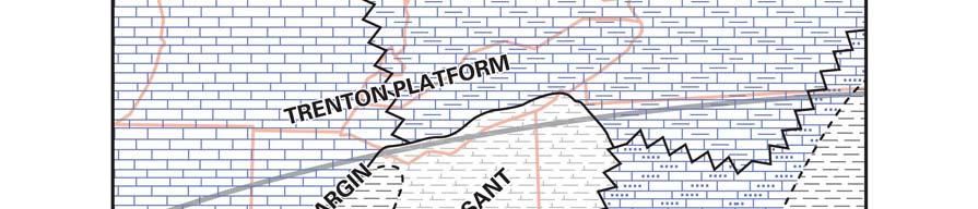
5 Facies map of Trenton/Point Pleasant time Cross section
6 Idealized platform to basin model and major facies UTICA-POINT PLEASANT SUB-BASIN
7 Sharp contact of Maquoketa Shale (Utica Equivalent) with the underlying Galena Dolomite (Trenton Limestone) in Vulcan Materials Co. Quarry, DeKalb County, IL. Courtesy of Paul Potter

8 TRNN/LXTN to BKRV isopach map C.I. = 50 ft
9
10 Utica is defined as dark gray to dark brown to black shale Modified from Patchen and others, 2006


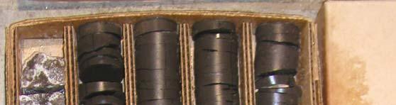
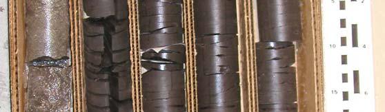
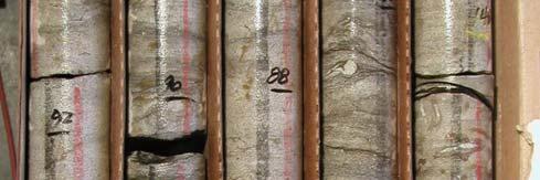
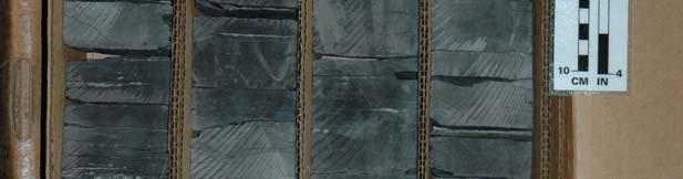
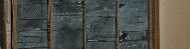
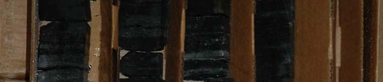
11 Utica/Point Pleasant core map for Ohio and surrounding region 36 cores Full diameter Sidewall


12 Millbrig


13


14


15


16


17 Millbrig


18 Logana Mbr., Utica/Point Pleasant Sub-basin Curdsville Mbr, Utica/Point Pleasant Sub-basin


19 Coshocton County API NO (Core no. 3003) # 3 Barth well
20 Coshocton County API NO (Core no. 3003) # 3 Barth well # 3 Barth, ft
21 Coshocton County API NO (Core no. 3003) # 3 Barth well Add Core photos # 3 Barth, ft


22 Tuscarawas County OGS CO 2 #1 well


23 OGS CO 2 # 1 APINO
: 0.0002 md Porosity : 51% 5.")


24 CO 2 No. 1 Well Tuscarawas County, Ohio Utica Shale Depth: FEET Permeability (Klink.): md Porosity : 51% 5.1% Grain Density: 2.70 gm/cc Lithology: ogy: Slightly fossiliferous, ous, silty mudstone (silty shale) Framework Grains: Common fine to medium silt-sized quartz and mica; scattered chambered calcareous fossil fragments Matrix: Abundant detrital clay Cements and Replacement Minerals: Minor amount calcite cement; scattered ferroan dolomite crystals replacing clay matrix; trace amount of microcrystalline pyrite replacement of shell material, organic material, and mud matrix.


25 OGS CO 2 # 1 APINO


 to argillaceous skeletal wackestone")


26 CO 2 No. 1 Well Tuscarawas County, Ohio Point Pleasant Depth: FEET Permeability (Klink.): md Porosity: 4.2% Grain Density: 2.70 gm/cc Lithology: Fossiliferous, slightly l dolomitic mudstone (shale) to argillaceous skeletal wackestone Framework Grains: Minor fine siltsized to medium silt-sized quartz and mica; abundant calcareous fossil fragments (typically concentrated in layers), including bivalves, echinoderm fragments ostracods, rare phosphatic shell fragments and brachiopod spines, common organic particles Matrix: Abundant detrital clay
27 Wood Co., WV APINO Power Oil Co.


28 Wood Co., WV APINO Power Oil Co. Power Oil Co., ft


29 Wood Co., WV APINO Power Oil Co. Power Oil, ft
30
31 Stratigraphic Cross Section
32
33 Rome Trough
34 DLGV
35 Summary Approximately billion BO have been generated in Ordovician shale units and already produced in Paleozoic reservoirs in Appalachian basin (Trenton, Black River, Knox, etc.) (Ryder, 1998). Based on TOC and drock keval ldata tied dinto facies and regional stratigraphy, exploration potential exists in Utica, Point Pleasant, and Logana black shale facies. Regional time lines and facies relationships are poorly understood in the Middle Ord. shales. Logana represents a good, correlatable, regional time line and may represent a flood surface. High TOC and interbedded brittle carbonates in Point Pleasant that enhance fracture potential make this an attractive target.
36 Further Work Needed Additional full-diameter cores, especially in eastern OH Additional TOC and Rock Eval Analyses Biostrat. and isotope work (C13, SR86/87 etc.) Develop Sequence Strat. Model Update and refine cross sections and mapping from previous studies Petrophysical and Mineralogic studies to assist in refining stratigraphy and determining best completion practices


37 References Cited Marcellus and Utica Shales Data and Maps Patchen and others, 2006, A Geologic Play Book for Trenton Black River Appalachian Basin Exploration, final report submitted to U.S. DOE. This report can be ordered at no cost from DOE at: h Ryder, R.T., 2008, Assessment of Appalachian basin oil and gas resources: Utica-Lower Paleozoic Total Petroleum System: U.S. Geological Survey Open-File Report
o - 399' ' ' ' ' T. D.
 Ii I I' I: VDMRWellNo W-1142 Operator: J W Miloncus Farm: Browning Wynn Well No. : 1 Location: Lee County 3300' N of 36 042'30" 1800' E of 83005' approx Elevation: 1975' (reported altimeter elevation)
Lithological variation of Middle Bakken reservoirs in SE Saskatchewan: implications for optimizing multi-stage hydraulic fracturing
 Lithological variation of Middle Bakken reservoirs in SE Saskatchewan: implications for optimizing multi-stage hydraulic fracturing Hairuo Qing, Guoxiang Chi, Adam Sturiala Dept of Geology University of
Sedimentology and Stratigraphy of Lower Smackover Tight Oil Carbonates: Key to Predictive Understanding of Reservoir Quality and Distribution
 Integrated Reservoir Solutions Sedimentology and Stratigraphy of Lower Smackover Tight Oil Carbonates: Key to Predictive Understanding of Reservoir Quality and Distribution Roger J. Barnaby Presented at
NORTH AMERICAN ANALOGUES AND STRATEGIES FOR SUCCESS IN DEVELOPING SHALE GAS PLAYS IN EUROPE Unconventional Gas Shale in Poland: A Look at the Science
 NORTH AMERICAN ANALOGUES AND STRATEGIES FOR SUCCESS IN DEVELOPING SHALE GAS PLAYS IN EUROPE Unconventional Gas Shale in Poland: A Look at the Science Presented by Adam Collamore Co-authors: Martha Guidry,
Detailed Sedimentology and Inorganic Geochemistry of the Dolgeville Formation and Utica Group of the Central Mohawk Valley, NY
 Detailed Sedimentology and Inorganic Geochemistry of the Dolgeville Formation and Utica Group of the Central Mohawk Valley, NY Daniel Miserendino Jeffrey T. Pietras Introduction and Purpose Drill cores
Utica Shale Drilling Activity and Resource Assessment in Ohio
 Utica Shale Drilling Activity and Resource Assessment in Ohio Larry Wickstrom, Chris Perry, Matthew Erenpreiss, and Ron Riley Ohio Department of Natural Resources Division of Geological Survey Coalition
Evan K. Franseen, Dustin Stolz, Robert H. Goldstein, KICC, Department of Geology, University of Kansas
 Reservoir Character of the Avalon Shale (Bone Spring Formation) of the Delaware Basin, West Texas and Southeast New Mexico: Effect of Carbonate-rich Sediment Gravity Flows Evan K. Franseen, Dustin Stolz,
Update on Trenton Black River Playbook Study-New York State Museum
 Update on Trenton Black River Playbook Study-New York State Museum Taury Smith, Rich Nyahay, Rick Bray, Courtney Lugert, Rose Schulze and Brian Slater New York State Museum Task 4: Geochemistry Task 1
I.S : What s in it and the role of the Geologist
 Institute of Geologists of Ireland Pyrite Course I.S. 398-1: What s in it and the role of the Geologist Michael L.J. Maher 4 December, 2013 Responsibilities of Geologist You re only the messenger! Classification
The North Dakota Bakken Play - Observations. Julie A. LeFever North Dakota Geological Survey
 The North Dakota Bakken Play - Observations Julie A. LeFever North Dakota Geological Survey The Basics Bakken Formation in North Dakota Upper & Lower Black Shale World Class Source Rock TOC s as high as
A Regional Diagenetic and Petrophysical Model for the Montney Formation, Western Canada Sedimentary Basin*
 A Regional Diagenetic and Petrophysical Model for the Montney Formation, Western Canada Sedimentary Basin* Noga Vaisblat 1, Nicholas B. Harris 1, Vincent Crombez 2, Tristan Euzen 3, Marta Gasparrini 2,
Fracture stratigraphy: Predicting fractures from small-scale lithologic and textural changes
 SCA2016-085 1/6 Fracture stratigraphy: Predicting fractures from small-scale lithologic and textural changes Laura Kennedy, Jack Beuthin, and Jaime Kostelnik; Weatherford Laboratories This paper was prepared
OWNER: Lone Star Cement Corporation DRILLER: R. L. Magette Well Drilling Corp. COUNTY: Norfolk (S. Norfolk). GEOLOGIC LOG. feet.
. GEOLOGIC LOG. feet.") Lone Star Cement Corporation DRILLER: R. L. Magette Well Drilling Corp. COUNTY: Norfolk (S. Norfolk). W: 2111 C: 165 TOTAL DEPTH: 800' GEOLOGIC LOG Depth feet in 0-40 No Samples YORKTOWN FORMATION (40-360')
Lone Star Cement Corporation DRILLER: R. L. Magette Well Drilling Corp. COUNTY: Norfolk (S. Norfolk). W: 2111 C: 165 TOTAL DEPTH: 800' GEOLOGIC LOG Depth feet in 0-40 No Samples YORKTOWN FORMATION (40-360')
OVERVIEW OF THE ROGERSVILLE SHALE IN WEST VIRGINIA. Philip Dinterman West Virginia Geological & Economic Survey May 11, 2017
 OVERVIEW OF THE ROGERSVILLE SHALE IN WEST VIRGINIA Philip Dinterman West Virginia Geological & Economic Survey May 11, 2017 ACKNOWLEDGEMENT Dave Harris, John Hickman, Kentucky Geological Survey DATA NOTE
Sedimentary Rocks. Origin, Properties and Identification. Geology Laboratory GEOL 101 Lab Ray Rector - Instructor
 Sedimentary Rocks Origin, Properties and Identification Geology Laboratory GEOL 101 Lab Ray Rector - Instructor Sedimentary Rock Origin and Identification Lab Pre-Lab Internet Link Resources 1) http://www.rockhounds.com/rockshop/rockkey/index.html
Core Technology for Evaluating the Bakken
 Core Technology for Evaluating the Bakken Fundamentals for Reservoir Quality Assessment and Completion Analysis John Kieschnick and Roberto Suarez-Rivera TerraTek 1 Topics Covered Core Technology Changes
A Geologic Play Book for Utica Shale Appalachian Basin Exploration
 Abstracts The following pages contain the compiled individual abstracts for each section of the Play Book. Please visit www.wvgs.wvnet.edu/utica or http://karl.nrcce.wvu.edu to access project content.
Evaluation of geological characteristics of the New Albany Shale as a potential liquids-from- shale play in the Illinois Basin
 2014 Eastern Unconventional Oil and Gas Symposium - November 5-7, 2014 in Lexington, Kentucky, USA http://www.euogs.org Evaluation of geological characteristics of the New Albany Shale as a potential liquids-fromshale
GeoCanada 2010 Working with the Earth
 Lithofacies Identification and the Implications for SAGD Well Planning in the McMurray Formation, Christina Lake Area, Alberta Travis Shackleton*, Robert Gardner, Sung Youn, Grace Eng and Lori Barth Cenovus
Minerals and Rocks Chapter 20
 Minerals and Rocks Chapter 20 Emily and Megan Earth System Science Interconnected Rocks and minerals Interior processes Erosion and deposition Water and air Elements of Earth by weight Made of atoms Earth
ROCK CLASSIFICATION AND IDENTIFICATION
 Name: Miramar College Grade: GEOL 101 - Physical Geology Laboratory SEDIMENTARY ROCK CLASSIFICATION AND IDENTIFICATION PRELAB SECTION To be completed before labs starts: I. Introduction & Purpose: The
GeoFlex. Quantitative cuttings analysis and imaging service
 GeoFlex Quantitative cuttings analysis and imaging service Bring the cuttings characterization lab to the field with the GeoFlex* quantitative cuttings analysis and imaging service from Geoservices, a
11/22/2010. Groundwater in Unconsolidated Deposits. Alluvial (fluvial) deposits. - consist of gravel, sand, silt and clay
 deposits. - consist of gravel, sand, silt and clay") Groundwater in Unconsolidated Deposits Alluvial (fluvial) deposits - consist of gravel, sand, silt and clay - laid down by physical processes in rivers and flood plains - major sources for water supplies
Groundwater in Unconsolidated Deposits Alluvial (fluvial) deposits - consist of gravel, sand, silt and clay - laid down by physical processes in rivers and flood plains - major sources for water supplies
GEOLOGIC LOG. sandy. coarse-grained, dark-green autochthonous glauconite; minor amount of sand-grade shell debris, foraminifers rare
 OWNER: William E. Hackney o (Rivercliff Subdivision) DRILLER: Pittman wood & Metal Products Co. COUNTY: Nansemond (Driver) VDMR: WWCR: TOTAL DEPTH: 2092 173 607' GEOLOGIC LOG Depth in feet COLUMBIA GROUP
Sedimentary Rocks. Origin, Properties and Identification. Physical Geology GEOL 100. Ray Rector - Instructor
 Sedimentary Rocks Origin, Properties and Identification Physical Geology GEOL 100 Ray Rector - Instructor Sedimentary Rock Origin and Identification Lab Pre-Lab Internet Link Resources 1) http://www.rockhounds.com/rockshop/rockkey/index.html
PETROLOGIC AND PETROPHYSICAL CHARACTERISTICS: MISSISSIPPIAN CHERT, OKLAHOMA MIN ZHAO. Bachelor of Science in Geology
 PETROLOGIC AND PETROPHYSICAL CHARACTERISTICS: MISSISSIPPIAN CHERT, OKLAHOMA By MIN ZHAO Bachelor of Science in Geology China University of Petroleum (Beijing) Beijing, China 2009 Submitted to the Faculty
Update on Geochemistry and Diagenetic Models. Taury Smith, Richard Nyahay and Reservoir Characterization Group
 Update on Geochemistry and Diagenetic Models Taury Smith, Richard Nyahay and Reservoir Characterization Group Biggest Well Onshore US in 2004: One of [Fortuna s] New York wells (Reed #1) produced at more
GEOL 101 Lecture 7. Weathering, Sediments. Rock Cycle. Least Stable. Most Stable. Weathering Ch. 5. Physical. Chemical
 GEOL 101 Lecture 7 Weathering, Sediments S. Kite Photo Bear Butte S.P., SD Rock Cycle Weathering Ch. 5 Physical (later) Chemical (now) Bowen s Reaction Series vs. Goldich s Weathering Series for sand-size
MAPPING AND RESERVOIR CHARACTERIZATION OF GEOLOGIC INTERVALS FOR NGL STORAGE APPLICATIONS
 MAPPING AND RESERVOIR CHARACTERIZATION OF GEOLOGIC INTERVALS FOR NGL STORAGE APPLICATIONS Robin V. Anthony 1, Doug Patchen 2, Jessica Moore 3, Michael Solis 4 1 PA DCNR, Bureau of Topographic & Geologic
Geotechnical Aspects of the Ohio River Bridges Project
 Geotechnical Aspects of the Ohio River Bridges Project Mark A. Litkenhus, PE Sr. Geotechnical Engineer Stephen H. Bickel, PE Sr. Geotechnical Engineer STGEC Ohio River Bridges at Louisville Geotechnical
BACKGROUND GEOLOGY. Hoaglund 1. Wichita Orogeny to the south (10k 15k uplift) Rapid erosion and deposition of uplifted granitic basement rock ~18,000
 Rapid erosion and deposition of uplifted granitic basement rock ~18,000") POST APPRAISAL OF THE MISSOURIAN HOGSHOOTER HYDROCARBON SYSTEM: IMPLICATIONS FOR FUTURE EXPLOITATION IN THE ANADARKO BASIN STEVE HOAGLUND (GEOLOGIST CHESAPEAKE ENERGY) BACKGROUND GEOLOGY Wichita Orogeny
POST APPRAISAL OF THE MISSOURIAN HOGSHOOTER HYDROCARBON SYSTEM: IMPLICATIONS FOR FUTURE EXPLOITATION IN THE ANADARKO BASIN STEVE HOAGLUND (GEOLOGIST CHESAPEAKE ENERGY) BACKGROUND GEOLOGY Wichita Orogeny
Sediment. Weathering: mechanical and chemical decomposition and disintegration of rock and minerals at the surface
 Sediment Some basic terminology Weathering: mechanical and chemical decomposition and disintegration of rock and minerals at the surface Erosion: removal of weathered rock and minerals from one place to
FACIES MODELING OF KAIS FORMATION LIMESTONE: A CASE STUDY OF KAFOR FIELD, WEST PAPUA, INDONESIA
 6 Special Issue on Science, Engineering & Environment, ISSN: 2186-2990, Japan DOI: https://doi.org/10.21660/2017.40.69647 FACIES MODELING OF KAIS FORMATION LIMESTONE: A CASE STUDY OF KAFOR FIELD, WEST
North Dakota Geological Survey
 Review of Hydrocarbon Production from the Stonewall and lower Interlake Formations: western North Dakota Williston Basin Timothy O. Nesheim North Dakota Geological Survey North Dakota Geological Survey
GEOLOGICAL LOG INTERPRETATION TUTORIAL
 GEOLOGICAL LOG INTERPRETATION TUTORIAL Text and Figures by Geoff Bohling and John Doveton The following pages will familiarize you with the basics of the geological interpretation of common logs as they
INTERV AL SHEET. VDMR Well No.: WELL NO. 699 WWCR #186. Oil Gas, Water_ X,Exp1oratory. From- To 300_ _ _ _
 ) Page,_-=-H~l,-- Date, 8~-~2~7_-~62=- PROP: PROP : BLUE RIDGE POULTRY AND EGG CXi. #2 COMP: COMP : SYDNOR COUNTY: SHENANDOAH COUNTY: (CDLUMB IA FURNACE) VDMR WELL NO. W699 FROM: TO : INTERV AL SHEET VDMR
Emily and Megan. Earth System Science. Elements of Earth by weight. Crust Elements, by weight. Minerals. Made of atoms Earth is mostly iron, by weight
 Emily and Megan Chapter 20 MINERALS AND ROCKS Earth System Science Interconnected Rocks and minerals Interior processes Erosion and deposition Water and air Elements of Earth by weight Made of atoms Earth
Outcrop Analog Lower Paleozoic Hydrothermal Dolomite Reservoirs, Mohawk Valley, New York
 Outcrop Analog Lower Paleozoic Hydrothermal Dolomite Reservoirs, Mohawk Valley, New York Fortuna Energy Inc. Richard Nyahay, Brian Slater, and Taury Smith New York State Museum Introduction Trenton Black
Tim Carr - West Virginia University
 Tim Carr - West Virginia University Exploration s Ultimate Goal is to Answer Four Questions: Where to Drill? What to Expect? How Certain? How Profitable? Location & Depth HC Volumes Chance of Success
Determination of Reservoir Properties from XRF Elemental Data in the Montney Formation
 Determination of Reservoir Properties from XRF Elemental Data in the Montney Formation Justin Besplug, Ron Spencer and Tom Weedmark - XRF Solutions - www.xrfsolutions.ca Abstract Portable X-Ray Fluorescence
Sedimentary Rocks. Origin, Properties and Identification. Physical Geology GEOL 101 Lab Ray Rector - Instructor
 Sedimentary Rocks Origin, Properties and Identification Physical Geology GEOL 101 Lab Ray Rector - Instructor Sedimentary Rock Origin and Identification Lab Pre-Lab Internet Link Resources 1) http://www.rockhounds.com/rockshop/rockkey/index.html
APPENDIX 8-B. SEM Imaging Prepared by Juergen Schieber of Indiana University
 APPENDIX 8-B. SEM Imaging Prepared by Juergen Schieber of Indiana University 1. API# 3700920034, Kerr-McGee No. 1 Schellsburg Unit, Bedford County, Pennsylvania Lexington/Trenton Formation, 7690 feet below
2003 GCSSEPM Foundation Ed Picou Fellowship Grant for Graduate Studies in the Earth Sciences Recipient
 2003 GCSSEPM Foundation Ed Picou Fellowship Grant for Graduate Studies in the Earth Sciences Recipient Tarek A. El Shayeb University of Texas at Austin Integrated reservoir characterization and 3-D diagenetic
Geology 252, Historical Geology, California State University, Los Angeles - professor: Dr. Alessandro Grippo
 LAB # 1 - CLASTIC ROCKS Background: - Mechanical and Chemical Weathering - Production of Clastic Sediment - Classification of Sediment according to size: Gravel, Sand, Silt, Clay - Erosion, Transportation
Fusselman/Devonian Study. of the Midland Basin, Texas
 Fusselman/Devonian Study of the Midland Basin, Texas Fusselman-Devonian Study of the Midland Basin, Texas Overview The Fusselman-Devonian study of the Midland Basin is designed to enhance both exploration
Clastic Textures. I. What is the sorting of sample numbers 60, 61, and 62? Answers on last page.
 Sed Rock s Sel f-instruction N ame Geology 100 Harbor Secti on Sedimentary rocks are usually identified in the field by their stratification or layering, which originates by the successive deposition of
Sedimentary Rocks. Weathering. Mechanical & Chemical Weathering. Sediments. Lithification. Deposition. Transport. Erosion.
 Lithification Sedimentary Rocks Sediments Deposition Transport Erosion Weathering Weathering The sediments that make up sedimentary rocks are produced by: Mechanical & Chemical Weathering Mechanical Weathering
snt s tone, locally shaly,carbonaceous( la:ally)
") Company: United Pr oduc inq Co,, Inc. -Farm: Pocahontas Mining Corp. Well No.: 1-1784 Elevation: 2519.4 Total Depth: 5735' Location: Buchanan County 50' S. of 37 015' 200' E. of 81 045' Drilling Commenced:
Company: United Pr oduc inq Co,, Inc. -Farm: Pocahontas Mining Corp. Well No.: 1-1784 Elevation: 2519.4 Total Depth: 5735' Location: Buchanan County 50' S. of 37 015' 200' E. of 81 045' Drilling Commenced:
Mud Sand Gravel. Clastic Textures
 Sed Rocks Self-Instruction Lab Name Geology 100 Harbor Section Please see the questions online before you begin. Sedimentary rocks are usually identified in the field by their stratification or layering,
Preliminary Investigations of the Hudson Bay Area Coal Deposits
 Preliminary Investigations of the Hudson Bay Area Coal Deposits Jason Berenyi, Arden Marsh and Ron Leray Saskatchewan Ministry of Energy and Resources www.er.gov.sk.ca Introduction Introduction Manville
TITLE PAGE. Creating a Geologic Play Book for Trenton-Black River Appalachian Basin Exploration. Semi-Annual Report
 TITLE PAGE Creating a Geologic Play Book for Trenton-Black River Appalachian Basin Exploration Semi-Annual Report Reporting Period Start Date: October 1, 2004 Reporting Period End Date: March 31, 2005
The Clearwater Formation: A Facies Study for SAGD Water Source in the Athabasca Oil Sands
 The Clearwater Formation: A Facies Study for SAGD Water Source in the Athabasca Oil Sands Wallace, J. and Lavigne, J Introduction Water source has become an increasingly important issue recently with the
Chapter 6 Pages of Earth s Past: Sedimentary Rocks
 Chapter 6 Pages of Earth s Past: Sedimentary Rocks Introduction! Drilling into the bottom of the North Sea, we encounter: " Soft mud and loose sand, silt, pebbles, and shells. Then: " Similar materials
Total Organic Carbon Variability in the Utica Shale of Northwest Ohio
 Total Organic Carbon Variability in the Utica Shale of Northwest Ohio Senior Thesis Submitted in partial fulfillment of the requirements for the Bachelor of Science Degree At The Ohio State University
OIL AND GAS PLAYS OF THE MICHIGAN BASIN, SOUTHERN ONTARIO. Terry Carter, Consulting Geologist London, Ontario
 OIL AND GAS PLAYS OF THE MICHIGAN BASIN, SOUTHERN ONTARIO Terry Carter, Consulting Geologist London, Ontario 1 Ontario Petroleum Industries Oil and Natural Gas 1250 oil wells, 1200 gas wells, annual production
Source Rock Characterization of the Carboniferous Golata Formation and Devonian Besa River Formation Outcrops, Liard Basin, Northwest Territories
 Source Rock Characterization of the Carboniferous Golata Formation and Devonian Besa River Formation Outcrops, Liard Basin, Northwest Territories Jonathan Rocheleau Northwest Territories Geoscience Office
Rock Physics of Shales and Source Rocks. Gary Mavko Professor of Geophysics Director, Stanford Rock Physics Project
 Rock Physics of Shales and Source Rocks Gary Mavko Professor of Geophysics Director, Stanford Rock Physics Project 1 First Question: What is Shale? Shale -- a rock composed of mud-sized particles, such
u. S. Geological Survey,
 VDMR Well No. Operator: Southwestern Oil and 'Gas Company Farm: Hagan Well No.: 1 Location: Wise County 9300' S. of 36 055') 600' E. of 82030,)approximate Elevation: 2500' Total Depth:3751' Drill'ing Comrilenced:
Sedimentary Environments Chapter 8
 Sedimentary Environments Chapter 8 Does not contain complete lecture notes. To be used to help organize lecture notes and home/test studies. What is a sedimentary rock? Sedimentary rocks are products of
High-resolution Sequence Stratigraphy of the Glauconitic Sandstone, Upper Mannville C Pool, Cessford Field: a Record of Evolving Accommodation
 Page No. 069-1 High-resolution Sequence Stratigraphy of the Glauconitic Sandstone, Upper Mannville C Pool, Cessford Field: a Record of Evolving Accommodation Thérèse Lynch* and John Hopkins, Department
An outcrop analogue for the Williston Basin Bakken hybrid play, the Sappington Formation in southwest Montana:
 An outcrop analogue for the Williston Basin Bakken hybrid play, the Sappington Formation in southwest Montana: Facies, stratigraphic architecture, and controls on porosity distribution Michael Hofmann
Table DR 1: Description of the lithologic succession encountered by the Enkingen (SUBO 18) drill core.
 drill core.") DR20130138 G. Arp et al. SUPPLEMENTARY FILES (GSA Data Repository) Figure DR 1: Facies types of the Enkingen (SUBO 18) drill core. (A) Facies 1 clay-rich conglomeratic sandstone, 18.32-18.50 m depth. (B)
DR20130138 G. Arp et al. SUPPLEMENTARY FILES (GSA Data Repository) Figure DR 1: Facies types of the Enkingen (SUBO 18) drill core. (A) Facies 1 clay-rich conglomeratic sandstone, 18.32-18.50 m depth. (B)
Depositional Model and Distribution of Marginal Marine Sands in the Chase Group, Hugoton Gas Field, Southwest Kansas and Oklahoma Panhandle
 Depositional Model and Distribution of Marginal Marine Sands in the Chase Group, Hugoton Gas Field, Southwest Kansas and Oklahoma Panhandle Nathan D. Winters, Martin K. Dubois, and Timothy R. Carr Kansas
Mud Sand Gravel. Clastic Textures
 Sed Rocks Self-Instruction Lab Name Geology 100 Harbor Section Read the sedimentary rocks chapter before you start. Sedimentary rocks are usually identified in the field by their stratification or layering,
The Eocene Gir Formation of the Ghani and Ed Dib Fields, Eastern Libya - an example of "Virtual Core Study"
 The Eocene Gir Formation of the Ghani and Ed Dib Fields, Eastern Libya - an example of "Virtual Core Study" Henry Williams*, Suncor Energy Inc., Calgary, AB hwilliams@suncor.com Summary The Gir Formation
Sediments and Sedimentary Rocks
 Sediments and Sedimentary Rocks (Shaping Earth s Surface, Part 2) Science 330 Summer 2005 What is a sedimentary rock? Products of mechanical and chemical weathering Account for about 5 percent of Earth
Geology 229 Engineering Geology. Lecture 6. Basic Rock Classification and Engineering Considerations (West, Chs. 2, 3, 4, 5)
") Geology 229 Engineering Geology Lecture 6 Basic Rock Classification and Engineering Considerations (West, Chs. 2, 3, 4, 5) Outline of this Lecture 1. Rock types and rock cycle 2. Geological and engineering
Geology 229 Engineering Geology Lecture 6 Basic Rock Classification and Engineering Considerations (West, Chs. 2, 3, 4, 5) Outline of this Lecture 1. Rock types and rock cycle 2. Geological and engineering
Downloaded 09/15/16 to Redistribution subject to SEG license or copyright; see Terms of Use at
 A Full Field Static Model of the RG-oil Field, Central Sirte Basin, Libya Abdalla Abdelnabi*, Kelly H. Liu, and Stephen Gao Missouri University of Science and Technology Summary Cambrian-Ordovician and
Carbonate Hand Samples
 Describing carbonate rocks in hand sample As for siliciclastic rocks, many aspects of carbonate rocks are best described in thin section, but you will often need to describe them in hand sample. That is
Geological Overview of the Niobrara Chalk Natural Gas Play
 Geological Overview of the Niobrara Chalk Natural Gas Play W. Lynn Watney Kansas Geological Survey KU Energy Research Center The University of Kansas Lawrence, KS Outline Geologic Setting Paleogeography
Stephanie B. Gaswirth and Kristen R. Mara
 U.S. Geological Survey Assessment of Undiscovered Resources in the Bakken and Three Forks Formations, Williston Basin, North Dakota, Montana, and South Dakota, 2013 Stephanie B. Gaswirth and Kristen R.
Porosity partitioning in sedimentary cycles: implications for reservoir modeling
 Porosity partitioning in sedimentary cycles: implications for reservoir modeling Gregor P. Eberli 1), Langhorne B. Smith 2), Elena Morettini 3), Layaan Al-Kharusi 1) 1) Comparative Sedimentology Laboratory,
SCOOP Woodford. Regional Field Study
 SCOOP Woodford Regional Field Study OVERVIEW The Woodford shale is an organic rich siliceous shale formation of late Devonian and early Mississippian age deposited throughout most of the Anadarko basin
The petrography of sandstone samples from the Upper Greensand Formation in southern England.
 BRITISH GEOLOGICAL SURVEY TECHNICAL REPORT Stratigraphy Series IR/05/138 The petrography of sandstone samples from the Upper Greensand Formation in southern England. G.K.Lott (British Geological Survey)
Introduction. Context of the study
 Geological Controls on Reservoir Properties of the Montney Formation in Northeastern BC: An integration of sequence stratigraphy, organic geochemistry, quantitative mineralogy and petrophysical analysis.
1. Summary of Observations from a 40-Meter Cored Interval of the New Albany Shale in Well 1-3 Kavanaugh, Daviess County, Indiana
 2004 Annual Field Conference of the Great Lakes Section of SEPM 1 1. Summary of Observations from a 40-Meter Cored Interval of the New Albany Shale in Well 1-3 Kavanaugh, Daviess County, Indiana by Remus
AER/AGS Special Report 99. QEMSCAN Analysis of Various Lithologies from Tight- and Shale-Gas Plays in Alberta
 AER/AGS Special Report 99 QEMSCAN Analysis of Various Lithologies from Tight- and Shale-Gas Plays in Alberta AER/AGS Special Report 99 QEMSCAN Analysis of Various Lithologies from Tight- and Shale-Gas
Ooids, Example #1 Pennsylvania, Union Furnace outcrop Black River Formation
 UNon-skeletal grains UOoids Ooids, Example #1 This oolitic grainstone occurs in the Black River Formation of Pennsylvania. The ooids in this thin section have not been extensively micritized and the original
EROSION, DEPOSITION AND SEDIMENTARY ROCKS. Reading: Earth Science Tarbuck and Lutgens Chapter 5: pages Chapter 3: pages 52-54, 61-69
 EROSION, DEPOSITION AND SEDIMENTARY ROCKS Reading: Earth Science Tarbuck and Lutgens Chapter 5: pages 124-133 Chapter 3: pages 52-54, 61-69 Base Level Resistant bed Resistant bed creates a local base level
Shale Diagenesis and Permeability: Examples from the Barnett Shale and the Marcellus Formation*
 Shale Diagenesis and Permeability: Examples from the Barnett Shale and the Marcellus Formation* Christopher M. Prince 1, Deborah D. Steele 2, Rafael Zelaya 3, and Charles A. Devier 1 Search and Discovery
GEOL.3250 Geology for Engineers Sedimentary & Metamorphic Rocks
 GEOL.3250 Geology for Engineers Sedimentary & Metamorphic Rocks Name I. Introduction The bulk of the earth's crust is composed of relatively few minerals. These can be mixed together, however, to give
Unraveling the stratigraphy of the Oriskany Sandstone: A necessity in assessing its site-specific carbon sequestration potential
 Unraveling the stratigraphy of the Oriskany Sandstone: A necessity in assessing its site-specific carbon sequestration potential Jaime Kostelnik and Kristin M. Carter ABSTRACT The widespread distribution,
What is a sedimentary rock?
 Sedimentary Rocks What is a sedimentary rock? Sedimentary rocks are products of mechanical and chemical weathering They account for only 5% of the top 10 miles of the outer crust, yet most of the earth
KOZENY S EQUATION FOR BETTER CORE ANALYSIS
 SCA213-48 1/6 KOZENY S EQUATION FOR BETTER CORE ANALYSIS Pudji Permadi, Institut Teknologi Bandung, Indonesia Andy Setyo Wibowo, PPPTMGB Lemigas, Indonesia This paper was prepared for presentation at the
Sedimentología Ayudantía Lectura 1 Carbonate minerals
 Carbonate minerals The most common minerals in this group are the calcium carbonates, calcite and aragonite, while dolomite (a magnesium calcium carbonate) and siderite (iron carbonate) are also frequently
Sedimentary Rocks Chapter 6
 Sedimentary Rocks Chapter 6 I. What is a sedimentary rock? A. Sedimentary rock 1) Rock made of detrital sediments (such as sand) or inorganic/organic chemical precipitates (such as calcite) 2) Detrital
GEOLOGIC LOG Sand - orange-brown, slightly clayey; fine- to medium-grained, very well-sorted, subangular to subrounded; trace of feldspar
 OWNER: Fred W. Haislip DRILLER: Douglas & Dickinson, Inc. COUNTY: Northumberland (Burgess) Depth in feet GEOLOGIC LOG VDMR: WWCR: TOTAL DEPTH: 2000 140 673' COLUMBIA GROUP (0-42') 0-10 Sand - orange-brown,
Reservoir Characteristics of the Birdbear Formation in West- Central Saskatchewan
 Reservoir Characteristics of the Birdbear Formation in West- Central Saskatchewan Chao Yang Petroleum Geology Branch Exploration and Geological Services Division Saskatchewan Ministry of Energy and Resources
The Shale Spectrum: Interdisciplinary understanding across oil shale, oil-bearing shale and gas shale plays
 The Center for Oil Shale Technology & Research & The Colorado School of Mines 31sᵗOil Shale Symposium October 17-21, 2011 at the Cecil H. & Ida Green Center, Colorado School of Mines, Golden, Colorado
1 Hfli. ^^Hi. 11 mw\i. mmsisi i lull I. IMMRrtHttiifHmiititlK. RibWh. llml ''.' 1 ffililsiillsll8 ill. iiiinitsim IK«
 l i. :,, v. i :! 1.» r =,
MIDDLE DEVONIAN PLAY MICHIGAN BASIN OF ONTARIO. Duncan Hamilton
 MIDDLE DEVONIAN PLAY MICHIGAN BASIN OF ONTARIO Duncan Hamilton 1 Middle Devonian Pools of the Michigan Basin 375+ Million Barrels Michigan 45+ million Barrels Ontario 2 Outline of Presentation History
INTERVAL SHEET. VDMfl. Well No.: Well No. lloo. Tota 1 depth,_~5,-,0",0,- Oil Gas Water~Exploratory' From-To From-To From-To
 Page' l'- INTERVAL SHEET VDMfl. Well No.: Well No. lloo WWCR483 Date'_~7~/~2~2~/~64~ PitOP: Town of McGaheysville Well #2 Sydnor COUNTY: Ro ckingham (McGaheysville) VDMR Well No: W-1100 From-To From-To
GEOLOGY, RESOURCES, AND POTENTIAL ACTIVITY LEVELS
 GEOLOGY, RESOURCES, AND POTENTIAL ACTIVITY LEVELS NAS Workshop on the Development of Unconventional Hydrocarbon Resources in the Appalachian Basin Ray Boswell, US DOE/NETL Morgantown, West Virginia September
Exploration / Appraisal of Shales. Petrophysics Technical Manager Unconventional Resources
 Exploration / Appraisal of Shales Rick Lewis Petrophysics Technical Manager Unconventional Resources Organic Shale Factors Controlling Gas Reservoir Quality Conventional sandstone Mineral framework Gas
R ENW Services - Geophysics & GIS
 Yankton Block 1 Vermillion Block 2 N 2 0 1 Block 3 Elk Point 2 3 4 5 6 MILES Block 4 R20-2002-01 0 1 2 3 4 5 6 7 8 9 10 KILOMETERS Block 5 Figure courtesy of ENW Services - Geophysics & GIS Block 6 Test
STACK/STACK EXTENSION MERAMEC /OSAGE/ WOODFORD STUDY
 STACK/STACK EXTENSION MERAMEC /OSAGE/ WOODFORD STUDY FIELD STUDIES OVERVIEW NUTECH has combined its expertise with the emerging interest in North American shale plays in order to develop the most detailed
Dakota Sandstone. of the Moxa Arch and Surrounding Green River Basin
 Dakota Sandstone of the Moxa Arch and Surrounding Green River Basin Dakota Sandstones of the Green River Basin Overview The Dakota sandstones of the Moxa Arch and surrounding Green River Basin remain attractive
Sedimentiogical study for subsurface section of Abu Khasib
 Journal of Genetic and Environmental Resources Conservation, 2013,1(2):79-83. www.jgerc.com Sedimentiogical study for subsurface section of Abu Khasib Sadi K. Jan Iraq Natural History Research Center and
Overview of Woodford Gas-Shale Play in Oklahoma, 2008 Update
 Oklahoma Gas Shales Conference October 22, 2008 Overview of Woodford Gas-Shale Play in Oklahoma, 2008 Update Brian J. Cardott Oklahoma Geological Survey Number of Wells 300 250 200 Oklahoma Shale-Gas Well