Tectonic Implications of Lower Mississippian Fort Payne Carbonate Mounds. Paul L. Scruggs, Bob Hatcher, Gene Lockyear, and Francis Fitzerald
|
|
|
- Loren Riley
- 6 years ago
- Views:
Transcription


1 Tectonic Implications of Lower Mississippian Fort Payne Carbonate Mounds Paul L. Scruggs, Bob Hatcher, Gene Lockyear, and Francis Fitzerald

2 Acknowledgements Gary Bible David Wright Miller Energy Resources Inc.
3 What is the Fort Payne Formation? Vast, heterogeneous, and puzzling Lewis and Potter, 1978 Diverse silicilastic and carbonate facies Covers from KY to Illinois Basin to AL and GA Early Mississippian Ma My research focuses on carbonate mound units within the Fort Payne

4 Lasemi et al., 1998
5 Why is the Fort Payne Important? Early Mississippian is a time of dynamic eustatic and tectonic change in this area Neoacadian Orogeny ( Ma) At least two major unconformities representing subaerial exposure Poorly studied in subsurface of Cumberland Plateau
6 Lower Mississippian System Chattanooga Shale Modified from Dr. Gary Bible (Unpublished) Unconformities in Fort Payne representing subaerial exposure above carbonate mounds
7 Oil and Gas significance TN s first commercial production in 1866 Shallow Fort Payne buildup in Overton County first million barrel oil field in Tennessee Oneida-West in Scott County Prior to 1970 ~ 1 million cumulative barrels in TN : ~1.9 million 90% from Fort Payne

8 Bureau of Land Management, 2008
9 Bureau of Land Management, 2008

10 Bureau of Land Management, 2008


11 Bureau of Land Management, 2008
12 Working Hypotheses Lower and upper Fort Payne bioherms represent different phases of Early Carboniferous mudmounds Upper Fort Payne mounds are probably not adequately explored These mounds can give clues to tectonic activity related to Acadian/Neocadian orogeny and uplift of the Nashville Dome
13 Early Mississippian Carbonate Buildups James and Wood from Facies Models 4, 2010
14 Bridges et al. Carbonate buildup Classifications Type 1: Fenestrate bryozoan- sponge spicule Type 2: Crinoid-bryozoan Type 3: Crinoid-brachiopod-fenestrate bryozoan Type 4: Coralgal- Aphralysia and bryozoan- coralgal Type 5: Trepostome- microthrombolite

15 Study Areas Fort Payne Outcrop Fort Payne in Subsurface

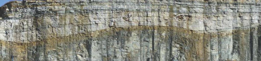
16 Highway 52 near Celina

17 New Road Cut South of Celina, opened in November miles of continuous exposure with uncoformity Max dip ~ 30

18 New Road Cut South of Celina, opened in November miles of continuous exposure with uncoformity Max dip ~ 30

19 New Road Cut South of Celina, opened in November miles of continuous exposure with uncoformity Max dip ~ 30

20 New Road Cut South of Celina, opened in November miles of continuous exposure with uncoformity Max dip ~ 30

21 New Road Cut South of Celina, opened in November miles of continuous exposure with uncoformity Max dip ~ 30
22 Unconformity

23 Soft-Sediment Feature On the northeast side of Hwy 52 north of Celina Three small crinoid mounds that have moved down a gentle paleo-slope Movement appears penecontemporaneous 3-D structure likely lobate NE SW

24 Hand Sample

25 Lower Fort Payne Bioherm Fossiliferous green shale core Interlayered crinoid rich wackestone and packstone thins on crest and distal ends Thickens on flanks Directly overlies Chattanooga Shale

26

27 Lower Fort Payne Bioherm Fossilferous green shale core Interlayered crinoid rich wackestone and packstone thins on crest and distal ends Thickens on flanks Directly overlies Chattanooga Shale Cross-section of Harmon Creek buildup exposed on Lake Cumberland, KY (Meyer et al., 1995)
 Dominantly bryozoan composition Well control in study")
28 Upper Fort Payne Mounds Above submound facies and capped by detrital non carbonate facies Generally on Chattanooga Shale highs Includes Tennessee s first million barrel field (Oneida West) Dominantly bryozoan composition Well control in study area

29 From Harry T. Moore

30 Upper Fort Payne Mounds Modified from Macquown and Perkins, 1982


31 Upper Fort Payne Mounds 731 Macquown and Perkins, 1982

32 Permit # 84: Oneida- West Field
33 Upper Fort Payne Mounds MacQuown and Perkins, 1982 Sciple, 1981
34 Depositional Environment Submound topography Determined by subaerial weathering Sciple, 1981


35 Depositional Environment Topography determined by pre-existing Chattanooga Shale Submound Chatt. Shale Mound Submound Modified from Lieber, 1978


36 Chattanooga Shale Structure Contour

37 Fort Payne Isopach
38 Mfp Structure Evenick dissertation, 2006
39 Mfp Residual Evenick dissertation, 2006
40 Mfp Isopach Evenick dissertation, 2006

41 MDc structure Evenick dissertation, 2006
42 MDc Residual Evenick dissertation, 2006
43 MDc-Od isopach Evenick dissertation, 2006
44 MDc-Od Ispoach wells Evenick dissertation, 2006

45 Analogs From N.A. Pickard, 1996 Recent Advances in Lower Carboniferous Geology

46 Sacramento Mountains, NM Jeffery, 1997

47 Early Mississippian Paleogeography ~0 Sacramento Mountains Ft. Payne Ft. Payne Modified from Blakey-

48 Sacramento Mountains Alamagordo member of the Lake Valley Formation Mound trends generally parallel to deformation trends Figure from Jeffery, 1997
49 Conclusions Fort Payne reefs could provide keys to eustatic and tectonic setting Timing of uplift on Nashville Dome Upper Fort Payne reefs are probably not adequately explored Upper and lower mounds are probably different phases and should not be treated as equivalent features
50 Future Work Structural relationships need to be more closely studied Well cores need to be studied in detail. Chattanooga Shale relationship to Fort Payne needs to be closely examined.
51
The McCully gas field in southern New Brunswick was discovered in the year 2000 on a joint drilling exploration venture by Corridor Resources Inc.
 1 The McCully gas field in southern New Brunswick was discovered in the year 2000 on a joint drilling exploration venture by Corridor Resources Inc. and Potash Corporation of Saskatchewan. Located about
Lower Mississippian Sequence Stratigraphy and Depositional Dynamics: Insights from the Outcrops, Northwestern Arkansas and Southwestern Missouri
 Lower Mississippian Sequence Stratigraphy and Depositional Dynamics: Insights from the Outcrops, Northwestern Arkansas and Southwestern Missouri Walter L. Manger Professor of Geology, Emeritus University
Seismic Reflection Imaging across the Johnson Ranch, Valley County, Idaho
 Seismic Reflection Imaging across the Johnson Ranch, Valley County, Idaho Report Prepared for the Skyline Corporation Lee M. Liberty Center for Geophysical Investigation of the Shallow Subsurface (CGISS)
Chapter 15. The Late Paleozoic World
 Chapter 15 The Late Paleozoic World Guiding Questions How did marine life of late Paleozoic time differ from that of middle Paleozoic time? How did terrestrial floras change on a global scale in late Paleozoic
Update on Trenton Black River Playbook Study-New York State Museum
 Update on Trenton Black River Playbook Study-New York State Museum Taury Smith, Rich Nyahay, Rick Bray, Courtney Lugert, Rose Schulze and Brian Slater New York State Museum Task 4: Geochemistry Task 1
Evan K. Franseen, Dustin Stolz, Robert H. Goldstein, KICC, Department of Geology, University of Kansas
 Reservoir Character of the Avalon Shale (Bone Spring Formation) of the Delaware Basin, West Texas and Southeast New Mexico: Effect of Carbonate-rich Sediment Gravity Flows Evan K. Franseen, Dustin Stolz,
Ordovician. System. Cambrian. System
 443 495 543 Late Middle Early Late Middle Early Ordovician System Cambrian System Earth History, Ch. 13 1 Ch. 13 Review: Early Paleozoic life & Burgess Shale fauna Most animal phyla originated in Cambrian;
Answers: Internal Processes and Structures (Isostasy)
") Answers: Internal Processes and Structures (Isostasy) 1. Analyse the adjustment of the crust to changes in loads associated with volcanism, mountain building, erosion, and glaciation by using the concept
Answers: Internal Processes and Structures (Isostasy) 1. Analyse the adjustment of the crust to changes in loads associated with volcanism, mountain building, erosion, and glaciation by using the concept
Structural Geology Lab. The Objectives are to gain experience
 Geology 2 Structural Geology Lab The Objectives are to gain experience 1. Drawing cross sections from information given on geologic maps. 2. Recognizing folds and naming their parts on stereoscopic air
Cretaceous, Dakota Formation, Terra Cotta Member South Side of I-70, Salina County, Kansas
 Cretaceous, Dakota Formation, Terra Cotta Member South Side of I-70, Salina County, Kansas Written By: Steven D.J. Baumann G-102010-1A Outcrop looking southeast Photo taken by: Steven Baumann on 10-20-2010
Data Repository item DATA REPOSITORY
 Data Repository item 2003053 1 DATA REPOSITORY Stable isotope and trace-element geochemistry of the basal Bouse Formation carbonate, southwestern USA: Implications for the Pliocene uplift history of the
Field trip to Racine Reef Complex, Thornton Quarry, Illinois
 Field trip to Racine Reef Complex, Thornton Quarry, Illinois Primary objectives for this fieldtrip 1) Collect and identify the fossils of the Racine Reef Complex. 2) Discuss procedures for collecting fossil
Lower Skinner Valley Fill Sandstones: Attractive Exploration Targets on the Northeast Oklahoma Platform*
 Lower Skinner Valley Fill Sandstones: Attractive Exploration Targets on the Northeast Oklahoma Platform* By Jim Puckette 1 Search and Discovery Article #10050 (2003) *Adapted from presentation to Tulsa
Sedimentary rocks. Mechanical Weathering. Weathering. Chemical weathering. Rates of weathering. Fossil Fuel Resources. Two kinds of weathering
 Sedimentary rocks Fossil Fuel Resources Exam next Tuesday February 14 Bring Scantron and Review Questions About 75% of all rock outcrops on the continents Important to reconstruct much of Earth's history
Mississippian Strata in Southeastern New Mexico, Including the Barnett Shale: Thickness, Structure and Hydrocarbon Plays
 Mississippian Strata in Southeastern New Mexico, Including the Barnett Shale: Thickness, Structure and Hydrocarbon Plays by Ronald F. Broadhead New Mexico Bureau of Geology and Mineral Resources A Division
Downloaded 03/27/18 to Redistribution subject to SEG license or copyright; see Terms of Use at
 Calibrating seismic fracture prediction using borehole image logs, application to the Mississippian Limestone Stephanie Cook*, Abdulmohsen Alali, Kurt J. Marfurt, Matthew J. Pranter The University of Oklahoma
DEVONIAN OIL AND GAS PLAYS OF THE MICHIGAN BASIN
 DEVONIAN OIL AND GAS PLAYS OF THE MICHIGAN BASIN William B. Harrison, III Michigan Geological Repository for Research and Education (MGRRE) Western Michigan University-Michigan Geological Survey 1 Devonian
Field Meeting Report: Coniston, led by Derek Leviston 18 th May 1986
 ISSN 1750-855X (Print) ISSN 1750-8568 (Online) Field Meeting Report: Coniston, led by Derek Leviston 18 th May 1986 Les Dolamore 1 DOLAMORE, L. (1987). Field Meeting Report: Carrock Fell, led by Derek
The Green River and Wasatch formations in the Lake Uinta, and
 DCA ~280m Oil-stained Sandstone Consortium Proposal: Lacustrine Reservoirs from Deep to Shallow: Facies Distribution, Architecture, and Source Rock Formation Green River Formation, Utah & Colorado Microbial
CHAPTER 3: COAL-BEARING INTERVALS OF THE BOURBON ARCH
 68 CHAPTER 3: COAL-BEARING INTERVALS OF THE BOURBON ARCH 69 3.1 Introduction The examination of Desmoinesian coal-bearing intervals includes: 1) facies successions and their associated well-log characteristics;
Structural Features and Fracture Orientation similarities between outcrops of the Ridgeley Sandstone
 The JUNIATA JOURNAL of GEOLOGY, 1, 1-8 (2014) Original article Structural Features and Fracture Orientation similarities between outcrops of the Ridgeley Sandstone Robert W. Baronner Two outcrops of the
Hydrocarbon Pools Of The Southeastern Great Slave Plain, Northwest Territories
 Hydrocarbon Pools Of The Southeastern Great Slave Plain, Northwest Territories Introduction E.P. Janicki* C.S. Lord Northern Geoscience Centre, Yellowknife, NWT ed_janicki@gov.nt.ca The geology of hydrocarbon
Masila 1: Shallow shelf carbonate facies variability and secondary reservoir development - Saar Formation Masila block, Yemen
 Masila 1: Shallow shelf carbonate facies variability and secondary reservoir development - Saar Formation Masila block, Yemen Kent Wilkinson* Nexen Inc., Calgary, AB kent_wilkinson@nexeninc.com ABSTRACT
THE QUATERNARY GEOLOGY OF NEWARK BAY AND KILL VAN KULL CHANNEL, NEW YORK AND NEW JERSEY. and
 THE QUATERNARY GEOLOGY OF NEWARK BAY AND KILL VAN KULL CHANNEL, NEW YORK AND NEW JERSEY Stephanie Beda, W. Bruce Ward, William Murphy, Robert Fleming, Gary Fleming, Beckett Boyd Earthworks LLC 27 Glen
Mountain Valley Pipeline, LLC Mountain Valley Pipeline Project FERC Docket No. CP
 Mountain Valley Pipeline, LLC Mountain Valley Pipeline Project FERC Docket No. CP16-10-000 Attachment 64 Site-specific Water Crossing and Restoration Plans Mountain Valley Pipeline, LLC Mountain
IP 121 ILLINOIS PETROLEUJM Illinois Institute of Natdral Resources STATE GEOWGICA SURVEY DIVISION' Jack A. Simon. Chief
 IP 121 ILLINOIS PETROLEUJM 121 1981 Illinois Institute of Natdral Resources STATE GEOWGICA SURVEY DIVISION' Jack A. Simon. Chief Stevenson, D. L. (David L.) Geologic structure of the base of the New Albany
The Problem of the Welden, Sycamore and Lower Caney in the Eastern Arbuckle Mountains
 120 PROC. OF THE OKLA. ACAD. OF SCI. FOR 1958 The Problem of the Welden, Sycamore and Lower Caney in the Eastern Arbuckle Mountains STEVE C. CHAMPLIN, University of Oklahoma, Norman This paper is a preliminary
PALEOGEOGRAPHY of NYS. Definitions GEOLOGIC PROCESSES. Faulting. Folding 9/6/2012. TOPOGRAPHIC RELIEF MAP of NYS GRADATIONAL TECTONIC
 TOPOGRAPHIC RELIEF MAP of NYS PALEOGEOGRAPHY of NYS Prof. Anthony Grande AFG 2012 Definitions GEOLOGIC PROCESSES Geography: study of people living on the surface of the earth. Geology: the scientific study
Continental Landscapes
 Continental Landscapes Landscape influenced by tectonics, climate & differential weathering Most landforms developed within the last 2 million years System moves toward an equilibrium Continental Landscapes
BACKGROUND GEOLOGY. Hoaglund 1. Wichita Orogeny to the south (10k 15k uplift) Rapid erosion and deposition of uplifted granitic basement rock ~18,000
 Rapid erosion and deposition of uplifted granitic basement rock ~18,000") POST APPRAISAL OF THE MISSOURIAN HOGSHOOTER HYDROCARBON SYSTEM: IMPLICATIONS FOR FUTURE EXPLOITATION IN THE ANADARKO BASIN STEVE HOAGLUND (GEOLOGIST CHESAPEAKE ENERGY) BACKGROUND GEOLOGY Wichita Orogeny
POST APPRAISAL OF THE MISSOURIAN HOGSHOOTER HYDROCARBON SYSTEM: IMPLICATIONS FOR FUTURE EXPLOITATION IN THE ANADARKO BASIN STEVE HOAGLUND (GEOLOGIST CHESAPEAKE ENERGY) BACKGROUND GEOLOGY Wichita Orogeny
Basin-wide Evaluation of the Uppermost Green River Formation s s Oil-Shale Resource, Uinta Basin, Utah and Colorado
 Basin-wide Evaluation of the Uppermost Green River Formation s s Oil-Shale Resource, Uinta Basin, Utah and Colorado Michael D. Vanden Berg Utah Geological Survey November 13, 2008 Acknowledgements U.S.
Stratigraphy and Hydrocarbon Production from Pennsylvanian Age Granite Wash Reservoirs in the Western Anadarko Basin, Oklahoma and Texas
 Stratigraphy and Hydrocarbon Production from Pennsylvanian Age Granite Wash Reservoirs in the Western Anadarko Basin, Oklahoma and Texas John Mitchell, Managing Partner/Consulting Geologist Fall River
Study the architecture and processes responsible for deformation of Earth s crust. Folding and Faulting
 Crustal Deformation AKA Structural geology (adapted from Brunkel, 2012) Study the architecture and processes responsible for deformation of Earth s crust. Folding and Faulting How Rocks Deform: 4 Controls
Improved Oil Recovery in the Cypress Using an Unconventional Approach
 Improved Oil Recovery in the Cypress Using an Unconventional Approach Nathan D. Webb IOGA Annual Convention March 2, 2017 2 Acknowledgments Project Co-PIs Scott Frailey Hannes Leetaru Geology Nathan Webb
Terrain Units PALEOGEOGRAPHY: LANDFORM CREATION. Present Geology of NYS. Detailed Geologic Map of NYS
 NYS TOPOGRAPHY Why so? PALEOGEOGRAPHY: LANDFORM CREATION Prof. Anthony Grande AFG 014 Present Geology of NYS Detailed Geologic Map of NYS Generalized Geology Detailed Geology Hot links to the fold out
KRIS wsbssm. IBHiiilll
 KRIS wsbssm IBHiiilll Digitized by the Internet Archive in 2012 with funding from University of Illinois Urbana-Champaign http://archive.org/details/engineeringaspec34ekbl STATE OF ILLINOIS HENRY HORNER,
Field Trip 1 Tunnel Mill, Vernon, Indiana: Waldron Shale
 Geol G308 Paleontology and Geology of Indiana Name: Field Trip 1 Tunnel Mill, Vernon, Indiana: Waldron Shale On this trip we will visit Tunnel Mill, which is located just south of Vernon, Indiana in the
TOPOGRAPHIC RELIEF MAP of NYS. LANDFORMS of NYS. Landforms. Creation of NYS Landforms 9/22/2011
 TOPOGRAPHIC RELIEF MAP of NYS LANDFORMS of NYS Prof. Anthony Grande AFG 2011 Landforms The basis of present-day landforms (surface features) is the bedrock geology that has been worked on by the forces
High-resolution Sequence Stratigraphy of the Glauconitic Sandstone, Upper Mannville C Pool, Cessford Field: a Record of Evolving Accommodation
 Page No. 069-1 High-resolution Sequence Stratigraphy of the Glauconitic Sandstone, Upper Mannville C Pool, Cessford Field: a Record of Evolving Accommodation Thérèse Lynch* and John Hopkins, Department
251 Million years. 299 Million years. 318 Million years. 359 Million years
 The Late Paleozoic 251 Million years 299 Million years 318 Million years 359 Million years Major Questions How did marine life of late Paleozoic time differ from that of middle Paleozoic time? How did
Geotechnical Aspects of the Ohio River Bridges Project
 Geotechnical Aspects of the Ohio River Bridges Project Mark A. Litkenhus, PE Sr. Geotechnical Engineer Stephen H. Bickel, PE Sr. Geotechnical Engineer STGEC Ohio River Bridges at Louisville Geotechnical
Later Mississippian. Sun, seas, and reefs
 Later Mississippian Sun, seas, and reefs P. David Polly Department of Geological Sciences Indiana University Bloomington, Indiana 47405 USA pdpolly@indiana.edu Bahama Banks Space shuttle photo by Chris
Evidence of a Sandy Suspended-Load Dominated River from the Mississippian Cypress Formation, Illinois, USA
 Evidence of a Sandy Suspended-Load Dominated River from the Mississippian Cypress Formation, Illinois, USA Kalin Howell 1, Nathan Webb 2, Jim Best 1,3, Eric Prokocki 1,4 1 Department of Geology, University
The Duvernay, Horn River and Canol Shales
 Western Canada s Giant Gas and Liquids Fairway: The Duvernay, Horn River and Canol Shales Brad J. Hayes Petrel Robertson Consulting Ltd. CERI 2015 Natural Gas Conference 1 Introduction Emerging unconventional
Yeso Formation along the Northwest Shelf, Southeast New Mexico, USA; Conventional or Unconventional Reservoir Development?*
 Yeso Formation along the Northwest Shelf, Southeast New Mexico, USA; Conventional or Unconventional Reservoir Development?* Matthew Wasson 1, Ron Luongo 1, Reed Stiles 1, and Mark Trees 1 Search and Discovery
Nathan D. Webb and James L. Best
 Nathan D. Webb and James L. Best Background Pennsylvanian oil production Stratigraphy & geologic setting Study area Methods Using geophysical logs & core Results Comparing three channel deposits Implications
LANDFORMS of NYS. Landforms. Exercise 4 9/13/2012. TOPOGRAPHIC RELIEF MAP of NYS. Physiographic map of NYS and vicinity showing Surface Features
 TOPOGRAPHIC RELIEF MAP of NYS LANDFORMS of NYS Prof. Anthony Grande AFG 2012 Landforms REMINDER: The basis of present-day landforms (surface features) is the bedrock geology that has been worked on by
LITHOLOGIC FACIES OF A PORTION OF THE STILLWATER FORMATION DON B. GOULD
 118 PROCEEDINGS OF THE OKLAHOMA a LITHOLOGIC FACIES OF A PORTION OF THE STILLWATER FORMATION DON B. GOULD University of Iowa, Iowa City, Iowa The Permian rocks of the world are noted for their unusual
CHAPTER 2. GEOLOGIC SETTING Martin K. Dubois
 CHAPTER 2. GEOLOGIC SETTING Martin K. Dubois Regional Geology The Hugoton field lies on the west side of the Hugoton embayment of the Anadarko basin and is bounded to the northwest by the Las Animas arch
ENGLE COAL FIELD. David E. Tabet
 OPEN FILE REPORT 115 SUMMARY OF THE GEOLOGY OF THE ENGLE COAL FIELD by David E. Tabet THE ENGLE COAL FIELD Introduction The Engle coal field (Lee, 1905), named for the small town of Engle along the Santa
The Origin of Prolific Reservoirs in the Geneva Dolomite (Middle Devonian), West-Central Illinois Basin
, West-Central Illinois Basin") IP 158 The Origin of Prolific Reservoirs in the Geneva Dolomite (Middle Devonian), West-Central Illinois Basin Beverly Seyler, John P. Grube, and Zakaria Lasemi Illinois Petroleum 158 2003 Rod R. Blagojevich,
IP 158 The Origin of Prolific Reservoirs in the Geneva Dolomite (Middle Devonian), West-Central Illinois Basin Beverly Seyler, John P. Grube, and Zakaria Lasemi Illinois Petroleum 158 2003 Rod R. Blagojevich,
Structural Style and Tectonic Evolution of the Nakhon Basin, Gulf of Thailand
 Structural Style and Tectonic Evolution of the Nakhon Basin, Gulf of Thailand Piyaphong Chenrai Petroleum Geoscience Program, Department of Geology, Faculty of Science, Chulalongkorn University, Bangkok
GEOLOGIC MAP OF THE. CHESTER 30 x 60 QUADRANGLE NORTH-CENTRAL MONTANA
 GEOLOGIC MAP OF THE CHESTER 30 x 60 QUADRANGLE NORTH-CENTRAL MONTANA by David A. Lopez Montana Bureau of Mines and Geology Open File Report MBMG 445 2002 This map has had preliminary reviews for conformity
East Gainsborough, Saskatchewan: a Prairie Evaporite salt dissolution and Mississippian erosional unconformity trap
 East Gainsborough, Saskatchewan: a Prairie Evaporite salt dissolution and Mississippian erosional unconformity trap Andre St.Onge* and Eric Strachan Upton Resources Inc., 3900, 205-5 th Avenue S.W., Calgary,
Geology of the Gull Lake North ASP Flood, Upper Shaunavon Formation, Southwest Saskatchewan
 Geology of the Gull Lake North ASP Flood, Upper Shaunavon Formation, Southwest Saskatchewan By Sid Leggett, Husky Energy (sid.leggett@huskyenergy.com) Acknowledgements Husky Energy Members of the Gull
Field Guide to the Flynn Creek Impact Structure
 Field Guide to the Flynn Creek Impact Structure 3D geologic map of the Flynn Creek impact structure. View to the east-northeast. Jonathan C. Evenick University of Tennessee Department of Earth and Planetary
GLY 155 Introduction to Physical Geology, W. Altermann. Press & Siever, compressive forces. Compressive forces cause folding and faulting.
 Press & Siever, 1995 compressive forces Compressive forces cause folding and faulting. faults 1 Uplift is followed by erosion, which creates new horizontal surface. lava flows Volcanic eruptions cover
Buried Bedrock Channels in the Athabasca Oil Sands Region Conceptual Understanding and Implications to Water Supply
 Buried Bedrock Channels in the Athabasca Oil Sands Region Conceptual Understanding and Implications to Water Supply Scott Rayner Matrix Solutions Inc. Sandra Rosenthal Devon Canada Corporation Presentation
VICKSBURG- JACKSON SHALE. by James A. McCarthy Houston, Texas INTRODUCTION
 6 NOTES E 0 s VICKSBURG- JACKSON SHALE by James A. McCarthy Houston, Texas RIDGE INTRODUCTION Calhoun County, which is within the limits of the Frio formation trend, is located in the central portion of
TYPES OF OSAGEAN/MERAMECIAN RESERVOIR SYSTEMS
 Field Examples of Osagean/Meramecian Reservoir Systems Goals by Kurt Rottmann Highlight the characteristics of the major reservoir systems Suggest how the Mississippian horizontal play can be expanded
OVERVIEW OF THE ROGERSVILLE SHALE IN WEST VIRGINIA. Philip Dinterman West Virginia Geological & Economic Survey May 11, 2017
 OVERVIEW OF THE ROGERSVILLE SHALE IN WEST VIRGINIA Philip Dinterman West Virginia Geological & Economic Survey May 11, 2017 ACKNOWLEDGEMENT Dave Harris, John Hickman, Kentucky Geological Survey DATA NOTE
GEOL 3700 STRUCTURE AND TECTONICS LABORATORY EXERCISE 3
 GEOL 3700 STRUCTURE AND TECTONICS LABORATORY EXERCISE 3 Goals: 1. Improve your map-reading and map-making skills. 2. Learn to generate and interpret structure contour maps. 3. Learn to generate and interpret
Introduction Geology
 Introduction The Wild Horse Anticline is located in the prolific Bighorn Basin of Wyoming about 5 miles northeast of the town of Basin. This structure demonstrates excellent fourway closure encompassing
Minnelusa Play: The impact of tectonics and an ancient dune field on production
 Minnelusa Play: The impact of tectonics and an ancient dune field on production Steven G. Fryberger ENHANCED OIL RECOVERY INSTITUTE Permian Tectonic Map of Wyoming 200 miles after Inden, et al, 1996 PermoPennsylvanian
FY 2013 Annual Technical Report for NCRDS State Cooperative Program
 FY 2013 Annual Technical Report for NCRDS State Cooperative Program SUBSURFACE GAS-SHALE SAMPLES OF THE UPPER DEVONIAN AND LOWER MISSISSIPPIAN WOODFORD SHALE, PERMIAN BASIN, WEST TEXAS AND SOUTHEASTERN
Fusselman/Devonian Study. of the Midland Basin, Texas
 Fusselman/Devonian Study of the Midland Basin, Texas Fusselman-Devonian Study of the Midland Basin, Texas Overview The Fusselman-Devonian study of the Midland Basin is designed to enhance both exploration
Maine Geologic Facts and Localities October, Lobster Lake, Maine. Text by Robert G. Marvinney. Maine Geological Survey
 Maine Geologic Facts and Localities October, 1998 Lobster Lake, Maine 45 o 51 7.91 N, 69 o 30 53.88 W Text by Robert G. Marvinney, Department of Agriculture, Conservation & Forestry 1 Map by Introduction
Benefits of Integrated Seismic and Gravity Exploration: An example from Norman Wells, NWT
 Benefits of Integrated Seismic and Gravity Exploration: An example from Norman Wells, NWT J. Helen Isaac* and Donald C. Lawton Fold-Fault Research Project, University of Calgary 2500 University Drive NW,
Structural Geology of the Mountains
 Structural Geology of the Mountains Clinton R. Tippett Shell Canada Limited, Calgary, Alberta clinton.tippett@shell.ca INTRODUCTION The Southern Rocky Mountains of Canada (Figure 1) are made up of several
Overview of Selected Shale Plays in New Mexico*
 Overview of Selected Shale Plays in New Mexico* Ron Broadhead 1 Search and Discovery Article #10627 (2014)** Posted August 18, 2014 *Adapted from presentation at RMAG luncheon meeting, Denver, Colorado,
Dakota Sandstone. of the Moxa Arch and Surrounding Green River Basin
 Dakota Sandstone of the Moxa Arch and Surrounding Green River Basin Dakota Sandstones of the Green River Basin Overview The Dakota sandstones of the Moxa Arch and surrounding Green River Basin remain attractive
Kent F. Perry. Gas Technology Institute Des Plaines, Illinois. Paper Presented October 6, th World Gas Conference Buenos Aires, Argentina
 New Albany Shale Gas Research Project Kent F. Perry Gas Technology Institute Des Plaines, Illinois U.S.A. Paper Presented October 6, 2009 24 th World Gas Conference Buenos Aires, Argentina Topics New Albany
GEOLOGIC MAPS PART II
 EARTH AND ENVIRONMENT THROUGH TIME LABORATORY - EES 1005 LABORATORY FIVE GEOLOGIC MAPS PART II Introduction Geologic maps of orogenic belts are much more complex than maps of the stable interior. Just
MARINE GEOLOGY & GEOGRAPHY
 MARINE GEOLOGY & GEOGRAPHY Bathymetry BATHYMETRY BATHYMETRY THE UNDERWATER EQUIVALENT TO TOPOGRAPHY THE STUDY OF WATER DEPTH A BATHYMETRIC MAP SHOWS FLOOR RELIEF OR TERRAIN AS CONTOUR LINES Bathymetry
entered a rapid development phase. Annual increased proven reserves are above 500 billion cubic meters (bcm) from 2003, and annual natural gas product
 from 2003, and annual natural gas product") (), entered a rapid development phase. Annual increased proven reserves are above 500 billion cubic meters (bcm) from 2003, and annual natural gas production has increased from 50bcm in 2000 to nearly
(), entered a rapid development phase. Annual increased proven reserves are above 500 billion cubic meters (bcm) from 2003, and annual natural gas production has increased from 50bcm in 2000 to nearly
ENGINEER S CERTIFICATION OF FAULT AREA DEMONSTRATION (40 CFR )
") PLATTE RIVER POWER AUTHORITY RAWHIDE ENERGY STATION BOTTOM ASH TRANSFER (BAT) IMPOUNDMENTS LARIMER COUNTY, CO ENGINEER S CERTIFICATION OF FAULT AREA DEMONSTRATION (40 CFR 257.62) FOR COAL COMBUSTION RESIDUALS
PLATTE RIVER POWER AUTHORITY RAWHIDE ENERGY STATION BOTTOM ASH TRANSFER (BAT) IMPOUNDMENTS LARIMER COUNTY, CO ENGINEER S CERTIFICATION OF FAULT AREA DEMONSTRATION (40 CFR 257.62) FOR COAL COMBUSTION RESIDUALS
How to Log Core (With Examples from the Williston Basin of Southeast Saskatchewan)
") How to Log Core (With Examples from the Williston Basin of Southeast Saskatchewan) D.M.Kent ( D.M.Kent Geological Consulting Ltd., Regina, Sask.), and J.H.Lake, (Lake Geological Services Inc, Swift Current,
How to Log Core (With Examples from the Williston Basin of Southeast Saskatchewan) D.M.Kent ( D.M.Kent Geological Consulting Ltd., Regina, Sask.), and J.H.Lake, (Lake Geological Services Inc, Swift Current,
Exploration Significance of Unconformity Structure on Subtle Pools. 1 Vertical structure characteristics of unconformity
 Exploration Significance of Unconformity Structure on Subtle Pools Wu Kongyou (China University of Petroleum,College of Geo-Resources and Information,Shandong Qingdao 266555) Abstract: Vertical structure
An outcrop analogue for the Williston Basin Bakken hybrid play, the Sappington Formation in southwest Montana:
 An outcrop analogue for the Williston Basin Bakken hybrid play, the Sappington Formation in southwest Montana: Facies, stratigraphic architecture, and controls on porosity distribution Michael Hofmann
Bedrock Geology of Altenburg Quadrangle
 STATEMAP Altenburg-BG Bedrock Geology of Altenburg Quadrangle Jackson County, Illinois and Perry County, Missouri Mary J. Seid, Joseph A. Devera, Allen L. Weedman, and Dewey H. Amos 2009 Institute of Natural
Outcrops from Every Continent and 20 Countries in 140 Contributions. Tor H. Nilsen, Roger D. Shew, Gary S. Steffens, and Joseph R.J. Studlick.
 Paper VIII Tor H. Nilsen, Roger D. Shew, Gary S. Steffens, and Joseph R.J. Studlick Editors Outcrops from Every Continent and 20 Countries in 140 Contributions http://bookstore.aapg.org Length ~ 23 m (75.5
Cenozoic Extensional Basin Development and Sedimentation in SW Montana
 Cenozoic Extensional Basin Development and Sedimentation in SW Montana Robert C. Thomas Department of Environmental Sciences, The University of Montana Western, Dillon, MT 59725, (406) 683-7615, r_thomas@umwestern.edu
General Geologic Setting and Seismicity of the FHWA Project Site in the New Madrid Seismic Zone
 General Geologic Setting and Seismicity of the FHWA Project Site in the New Madrid Seismic Zone David Hoffman University of Missouri Rolla Natural Hazards Mitigation Institute Civil, Architectural & Environmental
MAPPING BEDROCK: Verifying Depth to Bedrock in Calumet County using Seismic Refraction
 MAPPING BEDROCK: Verifying Depth to Bedrock in Calumet County using Seismic Refraction Revised December 13, 2011 Dave Hart Wisconsin Geological and Natural History Survey INTRODUCTION Seismic refraction
EAS 233 Geologic Structures and Maps Winter Miscellaneous practice map exercises. 1. Fault and separation:
 Miscellaneous practice map exercises 1. Fault and separation: With respect to Map 1, what are (a) the orientation of the fault, and (b) the orientation of bedding in the units cut by the fault. (c) Mark
Module 9 Sedimentary Rocks
 Module 9 Sedimentary Rocks SEDIMENTARY ROCKS Rocks formed from material derived from preexisting rocks by surfacial processes followed by diagenesis There are two main classes of sedimentary rocks Clastic
Geology of the Golden Gate National Recreation Area in the Marin Headlands, and Ring Mountain, Tiburon
 Geology of the Golden Gate National Recreation Area in the Marin Headlands, and Ring Mountain, Tiburon May 9, 2006 Field trip guide compiled by Mary Leech Name: Submit this guide with the Subduction lab
The Booch Sandstones (McAlester Formation, Krebs Group), Arkoma Basin, Oklahoma Outcrops to Well Logs: An Introduction to Oklahoma Fluvial Reservoirs*
, Arkoma Basin, Oklahoma Outcrops to Well Logs: An Introduction to Oklahoma Fluvial Reservoirs*") The Booch Sandstones (McAlester Formation, Krebs Group), Arkoma Basin, Oklahoma Outcrops to Well Logs: An Introduction to Oklahoma Fluvial Reservoirs* Neil H. Suneson 1 Search and Discovery Article #10210
The Booch Sandstones (McAlester Formation, Krebs Group), Arkoma Basin, Oklahoma Outcrops to Well Logs: An Introduction to Oklahoma Fluvial Reservoirs* Neil H. Suneson 1 Search and Discovery Article #10210
Search and Discovery Article #10532 (2013)** Posted October 21, Abstract
** Posted October 21, Abstract") Utilizing the Delta Log R Method for Determining Total Organic Carbon of the Niobrara Formation, B Bench, Denver-Julesburg Basin, Colorado and Wyoming* Madeline K. Beitz 1, Robert Cunningham 2, and Lisa
Utilizing the Delta Log R Method for Determining Total Organic Carbon of the Niobrara Formation, B Bench, Denver-Julesburg Basin, Colorado and Wyoming* Madeline K. Beitz 1, Robert Cunningham 2, and Lisa
EUSTATIC AND TECTONIC CONTROL OF SEDIMENTATION IN THE PENNSYLVANIAN STRATA OF THE CENTRAL APPALACHIAN BASIN, USA
 Comptes Rendus XII ICC-P Volume 2:421-430 Buenos Aires, 1993 EUSTATIC AND TECTONIC CONTROL OF SEDIMENTATION IN THE PENNSYLVANIAN STRATA OF THE CENTRAL APPALACHIAN BASIN, USA Donald R. CHESNUT Jr. Kentucky
Understanding Mississippi Dolomite Reservoirs in Central Kansas
 Understanding Mississippi Dolomite Reservoirs in Central Kansas Martin K. Dubois, Alan P. Byrnes, and Saibal Bhattacharya. We wish to acknowledge support by U.S. Department of Energy and Mull Drilling
APPENDIX C GEOLOGICAL CHANCE OF SUCCESS RYDER SCOTT COMPANY PETROLEUM CONSULTANTS
 APPENDIX C GEOLOGICAL CHANCE OF SUCCESS Page 2 The Geological Chance of Success is intended to evaluate the probability that a functioning petroleum system is in place for each prospective reservoir. The
depression above scarp scarp
 1 LAB 1: FIELD TRIP TO McKINLEYVILLE AND MOUTH OF THE MAD RIVER OBJECTIVES: a. to look at geomorphic and geologic evidence for large scale thrust-faulting of young sediments in the Humboldt Bay region
MESOZOIC BASINS. North Carolina Geological Survey
 MESOZOIC BASINS North Carolina Geological Survey The 1823 organic act which created the North Carolina Geological Survey (NCGS) tasked us to examine, describe and map the geology, geologic hazards, and
Pratice Surface Processes Test
 1. The cross section below shows the movement of wind-driven sand particles that strike a partly exposed basalt cobble located at the surface of a windy desert. Which cross section best represents the
The Niagara Escarpment extends from western New York, through the GTA all the way up to Manitoulin Island and into Michigan and Wisconsin.
 is southern Ontario s most prominent topographic feature, extending more than 500 kilometres from western New York, through Niagara Falls and the western part of the Greater Toronto Area (GTA), and north
Strike-Slip Faults. ! Fault motion is parallel to the strike of the fault.
 Strike-Slip Faults! Fault motion is parallel to the strike of the fault.! Usually vertical, no hanging-wall/footwall blocks.! Classified by the relative sense of motion. " Right lateral opposite block
Burrow-Mottled Carbonates in the Devonian Wabamun Formation, Pine Creek Gas Field, Alberta, Canada
 Page No. 142-1 Burrow-Mottled Carbonates in the Devonian Wabamun Formation, Pine Creek Gas Field, Alberta, Canada Gladys Fong Department of Earth and Atmospheric Sciences University of Alberta, Edmonton,
Continuity and Compartmentalization of Viking Formation gas production from the Ricinus / Bearberry area of the Rocky Mountain Triangle Zone
 Page No. 001-1 Continuity and Compartmentalization of Formation gas production from the Ricinus / Bearberry area of the Rocky Mountain Triangle Zone David Halwas* (Senior Staff Geologist), Darryl Parry
Plate tectonics model for the continental collisions during Late Paleozoic
 Alleghanian orogeny During Late Paleozoic, northwestern Africa collided with southeastern North America, causing the Alleghanian orogeny, and building the Appalachian mountains. The orogeny began during