Lower Mississippian Sequence Stratigraphy and Depositional Dynamics: Insights from the Outcrops, Northwestern Arkansas and Southwestern Missouri
|
|
|
- Alexina Wheeler
- 6 years ago
- Views:
Transcription
1 Lower Mississippian Sequence Stratigraphy and Depositional Dynamics: Insights from the Outcrops, Northwestern Arkansas and Southwestern Missouri Walter L. Manger Professor of Geology, Emeritus University of Arkansas Fayetteville, Arkansas INSIGHTS 1. The Mississippian Lime section represents a single, third-order (unconformity-bounded), transgressiveregressive, eustatic cycle. 2. Higher order cycles are also present, possibly reflecting climatic signatures. 3. Lower Mississippian lithologies reflect an impoverished, cratonic, carbonate factory dominated by crinozoan detritus and carbonate mud produced at very high rates within effective wave base. 4. Apparently, the play is developed in carbonates, potentially including oolite, that were transported down-ramp as lobate bodies and grain flows, and deposited below both effective and storm wave base. Manger 1
2 INSIGHTS, cont. 5. Chert characterizes the maximum flooding and highstand/regressive portions of the eustatic cycle. 6. Penecontemporaneous chert black, nodular, non- to poorly fossiliferous, disrupts bedding - formed below the sediment-water interface before the sediment was indurated during maximum flooding. 7. Later diagenetic chert white, bedded, fossiliferous, follows bedding formed by groundwater replacement along bedding planes of lithified carbonate following regression. INSIGHTS, cont. 8. Lithostratigraphic nomenclature for the four state region (Missouri, Arkansas, Oklahoma, Kansas) generally recognizes a chert-free, transgressive succession, succeeded by chert-bearing, maximum flooding and highstand/regressive successions. 9. The chert-free interval is thin compared to the chertbearing interval, and condensed, representing all or part of seven conodont zones and spanning the Kinderhookian- Osagean boundary. 10. The chert-free interval is apparently dolomitized in the subsurface and exhibits matrix porosity, yet in outcrop, it is mud-dominated, for the most part, and tight. 11. For the most part, lithostratigraphic subdivisions of the chert-bearing interval are based on chert development. Manger 2

3 INSIGHTS, cont. 12. Maximum flooding and highstand/regression lithostratigraphic subdivisions have not been mapped and their validity is suspect. 13. Highly fractured zones occur in both the penecontemporaneous chert of the maximum flooding interval, and the later diagenetic chert of the highstand/regressive systems tracts. 14. Tripolitic chert reservoirs appear to be confined to the highstand/ regressive interval. If so, it cannot represent intraformational unconformity development since that chert is a groundwater replacement. 15. The chert-bearing interval was deposited very rapidly, representing only three conodont zones and may span the Osagean-Meramecan boundary in some sections. 16. Where complete, the Lower Mississippian cycle concludes with crinozoan grainstones deposited in situ within effective wave base GEOLOGY OF THE NORTHERN AMERICAN MIDCONTINENT Dutch, 2001 Manger 3


4 MISSISSIPPIAN LITHOFACIES (SLOSS, DAPPLES, AND KRUMBEIN, 1960) Pre-CHESTERIAN/CHESTERIAN LITHOFACIES SHELL, 1970 Manger 4


5 Blakey, 2000 LOWER MISSISSIPPIAN PALEOGEOGRAPHY (BLAKEY, 2009) Manger 5
 AERIAL VIEW BAHAMA PLATFORM")
6 EARLY MISSISSIPPIAN PALEOGEOGRAPHY, SOUTHERN MIDCONTINENT, NORTH AMERICA (WITZKE AND OTHERS, 1990) AERIAL VIEW BAHAMA PLATFORM Manger 6


7 CARBONATE FACTORY 1 - CRINOZOANS LIVING AND FOSSIL MODERN CRINOIDS AND NICHE TIERING Ausich, 1980 Manger 7


8 CARBONATE FACTORY 2 CALCAREOUS ALGAE STOCKMAN, GINSBURG AND SHINN, 1967 CARBONATE FACTORY 2 - LIME MUDSTONE / MICRITE FOLK, 1959 DUNHAM, 1959 Manger 8


9 AERIAL VIEW - FLORIDA BAY CARBONATE MUD FACTORY WITH NET LOSS IN MUD VOLUME CRATONIC SEQUENCES, OROGENIC AND TECTONIC EVENTS IN THE HISTORY OF THE NORTH AMERICAN CRATON (LEVIN, 1991) Manger 9


10 CORRELATION OF ORDERS OF CARBONIFEROUS EUSTATIC CYCLICITY ( Waite, 2002) MISSISSIPPIAN LITHOSTRATIGRAPHY SOUTHWESTERN MISSOURI THOMPSON, 1986 Manger 10

 PENNSYLVANIAN SECTION")


11 LOWER MISSISSIPPIAN LITHOSTRATIGRAPHY, SOUTHERN MIDCONTINENT ARKANSAS (Manger and Shelby, 2000) OKLAHOMA KANSAS (Mazzulloand others, 2009) PENNSYLVANIAN SECTION MISSISSIPPI CHAT? UPPER BOONE CHERT-BEARING CRINOIDAL LIMESTONE LOWER BOONE CHERT-FREE DOLOMITIC LIMESTONE ST. JOE LIMESTONE WOODFORD ARBUCKLE OLSEN #2 WELL OSAGE CO., OK Manger 11


12 LOWER MISSISSIPPIAN OUTCROP, NORTHWESTERN ARKANSAS TRANSGRESSION TO MAXIMUM FLOODING INTERVAL = ST JOE AND LOWER BOONE GRAIN FLOW DEPOSITIONAL CYCLES CLIMATIC SIGNATURE? HIGH ORDER CYCLES IN COMPTON INTERVAL FLOATING CRINOZOAN DETRITUS IN MUD MATRIX PIERSON INTERVAL Manger 12


13 AERIAL VIEW BAHAMA PLATFORM SEDIMENT MOVEMENT AT SOUTHEASTERN END OF TONGUE OF THE OCEAN, BAHAMAS This sediment is mostly clean carbonate sand Manger 13


14 SEDIMENT MOVEMENT, SOUTH CAT CAY, BAHAMA PLATFORM This sediment is clean oolite LOWER MISSISSIPPIAN ISOPACHOUS MAPS ST JOE AND BOONE BOONE MIDDLE to UPPER OSAGEAN MERAMECAN? Terry, 1980 ST JOE MIDDLE KINDERHOOKIAN to LOWER OSAGEAN Manger 14


15 PENECONTEMPORANEOUS CHERT LOWER BOONE MAXIMUM FLOODING INTERVAL Opal A Opal CT Chalcedony Quartz Shrinkage fractures from de-watering Fractured chert reservoir? LATER DIAGENETIC CHERT UPPER BOONE HIGHSTAND AND REGRESSION Groundwater Replacement Along Bedding Planes Manger 15


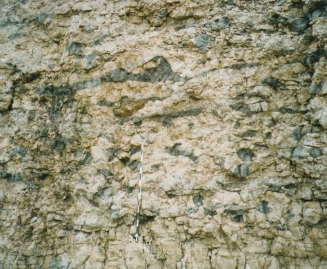
16 UPPER BOONE MISSISSIPPIAN OUTCROP, NORTHWESTERN ARKANSAS DEPOSITION WITHIN EFFECTIVE WAVE BASE REGRESSIVE CARBONATES WITH DIAGENETIC CHERT REPLACEMENT ALONG BEDDING PLANES LOBATE GEOMETRY UPPER BOONE WHITE = TRIPOLITIC CHERT/BROWN = LIMESTONE INTRA-LOBE INCREASE IN DIP, THICKENING, AND APPARENT GROWTH FAULT Manger 16


17 TRIPOLIC CHERT RESERVOIR HIGHSTAND/REGRESSION UPPER BOONE KEOKUK REGRESSIVE SEQUENCE Return to Effective Wave Base Mobile Skeletal Sand of Crinozoan Detritus Manger 17


 BASAL")

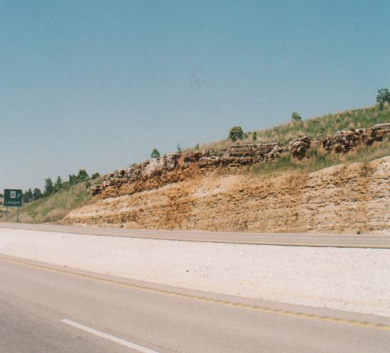
18 SHORT CREEK OOLITE GRAIN FLOW DEPOSIT WAR EAGLE QUARRY - ARKANSAS OSAGEAN-CHESTERIAN UNCONFORMITY THIRD-ORDER SEQUENCE BOUNDARY BOONE-HINDSVILLE UNCONFORMITY (ARROW) BASAL HINDSVILLE BRECCIA DERIVED FROM UPPER BOONE LATER DIAGENETIC CHERT Manger 18

 in the play area? 7.")
19 A FEW QUESTIONS NEEDING ANSWERS 1. Are both the maximum flooding (= Lower Boone) and highstand/regressive (= Upper Boone) intervals productive? 2. What types of reservoir intervals are developed? 3. Can the Lower Boone equivalent be tripolitic? 4. What is the geometry, distribution, and origin of the tripolitic chert intervals? 5. Can lobe, shelf, and carbonate factory geometries be determined, and do those geometries influence the distribution of reservoir quality carbonates? 6. What is the history of cratonic basin formation (Chautauqua,Cherokee, Forest City) in the play area? 7. What influence, if any, did basin formation have on the distribution of reservoir quality carbonates? CHEROKEE BASIN THROUGH TIME PRE-PENNSYLVANIAN (BELOW) Leatherock, 1945 PENNSYLVANIAN AND LATER PENNSYLVANIAN AND LATER (ABOVE) Chaplin, 1988 Manger 19

20 Manger 20
Analysis of Tripolitic Chert in the Boone Formation (Lower Mississippian, Osagean), Northwest Arkansas and Southwestern Missouri
, Northwest Arkansas and Southwestern Missouri") University of Arkansas, Fayetteville ScholarWorks@UARK Theses and Dissertations 8-2013 Analysis of Tripolitic Chert in the Boone Formation (Lower Mississippian, Osagean), Northwest Arkansas and Southwestern
University of Arkansas, Fayetteville ScholarWorks@UARK Theses and Dissertations 8-2013 Analysis of Tripolitic Chert in the Boone Formation (Lower Mississippian, Osagean), Northwest Arkansas and Southwestern
Depositional History of the St. Joe and Boone Formations in Northern Arkansas
 Journal of the Arkansas Academy of Science Volume 40 Article 22 1986 Depositional History of the St. Joe and Boone Formations in Northern Arkansas Phillip R. Shelby University of Arkansas, Fayetteville
Upper Viséan (Meramecian-Chesterian) Conodont Biostratigraphy of the SW Ozarks of NW Oklahoma, SW Missouri, and NW Arkansas
 Conodont Biostratigraphy of the SW Ozarks of NW Oklahoma, SW Missouri, and NW Arkansas") Upper Viséan (Meramecian-Chesterian) Conodont Biostratigraphy of the SW Ozarks of NW Oklahoma, SW Missouri, and NW Arkansas Cory J. Godwin 1 and James O. Puckette 2 1 Consulting Geologist, Tulsa, Oklahoma,
Upper Viséan (Meramecian-Chesterian) Conodont Biostratigraphy of the SW Ozarks of NW Oklahoma, SW Missouri, and NW Arkansas Cory J. Godwin 1 and James O. Puckette 2 1 Consulting Geologist, Tulsa, Oklahoma,
Mississippian Stratigraphic Nomenclature Revisions in Kansas
 Mississippian Stratigraphic Nomenclature Revisions in Kansas Evan K. Franseen 1,3, Robert S. Sawin 1,3, W. Lynn Watney 1,3, Ronald R. West 2,3, Anthony Layzell 1,3, and Greg A. Ludvigson 1,3 1 Kansas Geological
 Goebel, 1968 Watney, Guy and Byrnes, 2001 Thompson, 1986 PENN CHESTERIAN DES MOINESIAN CHEROKEE CHESTER INOLA LIME BARTLESVILLE MISSISSIPPIAN/PENNSYLVANIAN? CHAT (EROSIONAL RESIDIUM AT UNCONFORMITY) Fig
University of Arkansas, Fayetteville. Thomas Cahill University of Arkansas, Fayetteville. Theses and Dissertations
 University of Arkansas, Fayetteville ScholarWorks@UARK Theses and Dissertations 5-2014 Subsurface Sequence Stratigraphy and Reservoir Characterization of the Mississippian Limestone (Kinderhookian to Meramecian),
Mechanical Stratigraphy of the Mississippian in Osage County, Oklahoma
 University of Arkansas, Fayetteville ScholarWorks@UARK Theses and Dissertations 5-2014 Mechanical Stratigraphy of the Mississippian in Osage County, Oklahoma Caleb James Jennings University of Arkansas,
TYPES OF OSAGEAN/MERAMECIAN RESERVOIR SYSTEMS
 Field Examples of Osagean/Meramecian Reservoir Systems Goals by Kurt Rottmann Highlight the characteristics of the major reservoir systems Suggest how the Mississippian horizontal play can be expanded
Downloaded 03/27/18 to Redistribution subject to SEG license or copyright; see Terms of Use at
 Calibrating seismic fracture prediction using borehole image logs, application to the Mississippian Limestone Stephanie Cook*, Abdulmohsen Alali, Kurt J. Marfurt, Matthew J. Pranter The University of Oklahoma
Downloaded 01/29/13 to Redistribution subject to SEG license or copyright; see Terms of Use at
 An integrated study of a Mississippian tripolitic chert reservoir Osage County, Oklahoma, USA Benjamin L. Dowdell*, Atish Roy, and Kurt J. Marfurt, The University of Oklahoma Summary With the advent of
Fusselman/Devonian Study. of the Midland Basin, Texas
 Fusselman/Devonian Study of the Midland Basin, Texas Fusselman-Devonian Study of the Midland Basin, Texas Overview The Fusselman-Devonian study of the Midland Basin is designed to enhance both exploration
Evan K. Franseen, Dustin Stolz, Robert H. Goldstein, KICC, Department of Geology, University of Kansas
 Reservoir Character of the Avalon Shale (Bone Spring Formation) of the Delaware Basin, West Texas and Southeast New Mexico: Effect of Carbonate-rich Sediment Gravity Flows Evan K. Franseen, Dustin Stolz,
PETROLOGIC AND PETROPHYSICAL CHARACTERISTICS: MISSISSIPPIAN CHERT, OKLAHOMA MIN ZHAO. Bachelor of Science in Geology
 PETROLOGIC AND PETROPHYSICAL CHARACTERISTICS: MISSISSIPPIAN CHERT, OKLAHOMA By MIN ZHAO Bachelor of Science in Geology China University of Petroleum (Beijing) Beijing, China 2009 Submitted to the Faculty
Dakota Sandstone. of the Moxa Arch and Surrounding Green River Basin
 Dakota Sandstone of the Moxa Arch and Surrounding Green River Basin Dakota Sandstones of the Green River Basin Overview The Dakota sandstones of the Moxa Arch and surrounding Green River Basin remain attractive
The Sequence Stratigraphic and Paleogeograhic Distribution of Reservoir-Quality Dolomite, Madison Formation, Wyoming and Montana
 The Sequence Stratigraphic and Paleogeograhic Distribution of Reservoir-Quality Dolomite, Madison Formation, Wyoming and Montana TAURY SMITH AND GREGOR EBERLI The primary aim of this study is to show the
Sedimentology and Stratigraphy of Lower Smackover Tight Oil Carbonates: Key to Predictive Understanding of Reservoir Quality and Distribution
 Integrated Reservoir Solutions Sedimentology and Stratigraphy of Lower Smackover Tight Oil Carbonates: Key to Predictive Understanding of Reservoir Quality and Distribution Roger J. Barnaby Presented at
Sequence Biostratigraphy and Depositional Modelling of the Pennsylvanian-Permian Belloy Formation Peace River Embayment, Alberta Canada
 Page No. 104-1 Sequence Biostratigraphy and Depositional Modelling of the Pennsylvanian-Permian Belloy Formation Peace River Embayment, Alberta Canada Lindsay A. Dunn* and Charles M. Henderson Applied
Porosity partitioning in sedimentary cycles: implications for reservoir modeling
 Porosity partitioning in sedimentary cycles: implications for reservoir modeling Gregor P. Eberli 1), Langhorne B. Smith 2), Elena Morettini 3), Layaan Al-Kharusi 1) 1) Comparative Sedimentology Laboratory,
Depositional Sequences Sequences
 Depositional Sequences Transgressive and Regressive packages can be bound by unconformities Because sediment can only be preserved during net aggradation and progradation All other times there is either
MISSISSIPPIAN DEPOSITIONAL HISTORY OF THE TEXAS PANHANDLE: A REAPPRAISAL. Stephen C. Ruppel. Topical Report
 OF-WTWI-1985-15 Revision 1 MISSISSIPPIAN DEPOSITIONAL HISTORY OF THE TEXAS PANHANDLE: A REAPPRAISAL Stephen C. Ruppel Topical Report Prepared for the U. S. Department of Energy Salt Repository Project
The Geology of the Arbuckle Group in the Midcontinent: Sequence Stratigraphy, Reservoir Development, and the Potential for Hydrocarbon Exploration*
 The Geology of the Arbuckle Group in the Midcontinent: Sequence Stratigraphy, Reservoir Development, and the Potential for Hydrocarbon Exploration* Richard D. Fritz 1, Patrick Medlock 2, Michael J. Kuykendall
Plate tectonics model for the continental collisions during Late Paleozoic
 Alleghanian orogeny During Late Paleozoic, northwestern Africa collided with southeastern North America, causing the Alleghanian orogeny, and building the Appalachian mountains. The orogeny began during
QUANTIFYING AND ANALYZING RELATIONSHIPS BETWEEN WELL LOG ATTRIBUTES AND PRODUCTION FOR THE MISSISSIPPIAN PLAY IN WOODS COUNTY, OK CLINT BAREFOOT
 QUANTIFYING AND ANALYZING RELATIONSHIPS BETWEEN WELL LOG ATTRIBUTES AND PRODUCTION FOR THE MISSISSIPPIAN PLAY IN WOODS COUNTY, OK By CLINT BAREFOOT Bachelor of Science in Business Administration Oklahoma
FACIES MODELING OF KAIS FORMATION LIMESTONE: A CASE STUDY OF KAFOR FIELD, WEST PAPUA, INDONESIA
 6 Special Issue on Science, Engineering & Environment, ISSN: 2186-2990, Japan DOI: https://doi.org/10.21660/2017.40.69647 FACIES MODELING OF KAIS FORMATION LIMESTONE: A CASE STUDY OF KAFOR FIELD, WEST
Petrographic Comparison and Contrast of Fluvial and Deltaic Sandstones, Upper Pennsylvanian Oread Cyclothem, NE Oklahoma
 Missouri University of Science and Technology Scholars' Mine Geosciences and Geological and Petroleum Engineering Faculty Research & Creative Works Geosciences and Geological and Petroleum Engineering
The boundary between two formations (or any distinct layers) is called a contact. Sedimentary rocks cover 75% of continents.
 is called a contact. Sedimentary rocks cover 75% of continents.") Sedimentary Rocks Sedimentary rocks form at the Earth s surface through interactions of the hydrologic system and the crust. Fortunately, many of these processes are in operation today, and geologists
Sedimentary Rocks Sedimentary rocks form at the Earth s surface through interactions of the hydrologic system and the crust. Fortunately, many of these processes are in operation today, and geologists
SEDIMENTARY PHOSPHORITES: GENESIS, FACIES AND OCCURRENCE. Peter Berger Samantha Dwyer Jessica Hellwig Eric Obrock Kristin Read
 SEDIMENTARY PHOSPHORITES: GENESIS, FACIES AND OCCURRENCE Peter Berger Samantha Dwyer Jessica Hellwig Eric Obrock Kristin Read Introduction Phosphogenesis & Deposystems Facies Case Studies: Western U.S.,
Sedimentary facies and sequence stratigraphy of the Asmari Formation at Tange Arabi,Zagros Basin, Iran
 Sedimentary facies and sequence stratigraphy of the Asmari Formation at Tange Arabi,Zagros Basin, Iran Atefe Abbasi, Geology student of Shiraz Payam-noor University Abstract The Oligocene Miocene ASMARI
How to Log Core (With Examples from the Williston Basin of Southeast Saskatchewan)
") How to Log Core (With Examples from the Williston Basin of Southeast Saskatchewan) D.M.Kent ( D.M.Kent Geological Consulting Ltd., Regina, Sask.), and J.H.Lake, (Lake Geological Services Inc, Swift Current,
How to Log Core (With Examples from the Williston Basin of Southeast Saskatchewan) D.M.Kent ( D.M.Kent Geological Consulting Ltd., Regina, Sask.), and J.H.Lake, (Lake Geological Services Inc, Swift Current,
UNIVERSITY OF OKLAHOMA GRADUATE COLLEGE
 UNIVERSITY OF OKLAHOMA GRADUATE COLLEGE FRACTURE CHARACTERIZATION OF THE MISSISSIPPI LIME UTILIZING WHOLE CORE, HORIZONTAL BOREHOLE IMAGES, AND 3D SEISMIC DATA FROM A MATURE FIELD IN NOBLE COUNTY OKLAHOMA
Geological Overview of the Niobrara Chalk Natural Gas Play
 Geological Overview of the Niobrara Chalk Natural Gas Play W. Lynn Watney Kansas Geological Survey KU Energy Research Center The University of Kansas Lawrence, KS Outline Geologic Setting Paleogeography
A Geochemical Analysis of the Arkansas Novaculite and Comparison to the Siliceous Deposits of the Boone Formation
 University of Arkansas, Fayetteville ScholarWorks@UARK Theses and Dissertations 5-2016 A Geochemical Analysis of the Arkansas Novaculite and Comparison to the Siliceous Deposits of the Boone Formation
NORTH AMERICAN ANALOGUES AND STRATEGIES FOR SUCCESS IN DEVELOPING SHALE GAS PLAYS IN EUROPE Unconventional Gas Shale in Poland: A Look at the Science
 NORTH AMERICAN ANALOGUES AND STRATEGIES FOR SUCCESS IN DEVELOPING SHALE GAS PLAYS IN EUROPE Unconventional Gas Shale in Poland: A Look at the Science Presented by Adam Collamore Co-authors: Martha Guidry,
Mississippian Strata in Southeastern New Mexico, Including the Barnett Shale: Thickness, Structure and Hydrocarbon Plays
 Mississippian Strata in Southeastern New Mexico, Including the Barnett Shale: Thickness, Structure and Hydrocarbon Plays by Ronald F. Broadhead New Mexico Bureau of Geology and Mineral Resources A Division
Sequence Stratigraphy: An Applied Workshop
 Sequence Stratigraphy: An Applied Workshop Instructor: Prof. Octavian Catuneanu Level: Intermediate Duration: 5 days Course Description and Objectives This workshop presents the concepts and practical
Sedimentary rocks. Mechanical Weathering. Weathering. Chemical weathering. Rates of weathering. Fossil Fuel Resources. Two kinds of weathering
 Sedimentary rocks Fossil Fuel Resources Exam next Tuesday February 14 Bring Scantron and Review Questions About 75% of all rock outcrops on the continents Important to reconstruct much of Earth's history
The Problem of the Welden, Sycamore and Lower Caney in the Eastern Arbuckle Mountains
 120 PROC. OF THE OKLA. ACAD. OF SCI. FOR 1958 The Problem of the Welden, Sycamore and Lower Caney in the Eastern Arbuckle Mountains STEVE C. CHAMPLIN, University of Oklahoma, Norman This paper is a preliminary
Lecture 24: Paleozoic 1:
 UNIVERSITY OF SOUTH ALABAMA GY 112: Earth History Lecture 24: Paleozoic 1: Laurentia Instructor: Dr. Douglas W. Haywick Last Time (before the exam) The Cambrian Explosion A) Why a Cambrian explosion B)
The Green River and Wasatch formations in the Lake Uinta, and
 DCA ~280m Oil-stained Sandstone Consortium Proposal: Lacustrine Reservoirs from Deep to Shallow: Facies Distribution, Architecture, and Source Rock Formation Green River Formation, Utah & Colorado Microbial
Tectonic Implications of Lower Mississippian Fort Payne Carbonate Mounds. Paul L. Scruggs, Bob Hatcher, Gene Lockyear, and Francis Fitzerald
 Tectonic Implications of Lower Mississippian Fort Payne Carbonate Mounds Paul L. Scruggs, Bob Hatcher, Gene Lockyear, and Francis Fitzerald Acknowledgements Gary Bible David Wright Miller Energy Resources
Sedimentary Rocks. Origin, Properties and Identification. Physical Geology GEOL 100. Ray Rector - Instructor
 Sedimentary Rocks Origin, Properties and Identification Physical Geology GEOL 100 Ray Rector - Instructor Sedimentary Rock Origin and Identification Lab Pre-Lab Internet Link Resources 1) http://www.rockhounds.com/rockshop/rockkey/index.html
GY 112 Lecture Notes Rock Review
 GY 112 Lecture Notes D. Haywick (2006) 1 GY 112 Lecture Notes Rock Review Lecture Goals: A) Recap of rock types B) Recap of the rock cycle C) Sedimentary rocks: their role in earth history Textbook reference:
Sedimentary Rocks. Origin, Properties and Identification. Geology Laboratory GEOL 101 Lab Ray Rector - Instructor
 Sedimentary Rocks Origin, Properties and Identification Geology Laboratory GEOL 101 Lab Ray Rector - Instructor Sedimentary Rock Origin and Identification Lab Pre-Lab Internet Link Resources 1) http://www.rockhounds.com/rockshop/rockkey/index.html
Understanding Mississippi Dolomite Reservoirs in Central Kansas
 Understanding Mississippi Dolomite Reservoirs in Central Kansas Martin K. Dubois, Alan P. Byrnes, and Saibal Bhattacharya. We wish to acknowledge support by U.S. Department of Energy and Mull Drilling
Structural Styles and Geotectonic Elements in Northwestern Mississippi: Interpreted from Gravity, Magnetic, and Proprietary 2D Seismic Data
 Structural Styles and Geotectonic Elements in Northwestern Mississippi: Interpreted from Gravity, Magnetic, and Proprietary 2D Seismic Data Nick Loundagin 1 and Gary L. Kinsland 2 1 6573 W. Euclid Pl.,
Unconventional Oil Plays Opportunity vs Risk
 Unconventional Oil Plays Opportunity vs Risk EnerCom s London Oil & Gas Conference 4 June 14, 2012 Sofitel London Danny D. Simmons 1000 BOPD - What a great well! 10,000 1,000 BOPD 100 10 12/2009 1/2010
Later Mississippian. Sun, seas, and reefs
 Later Mississippian Sun, seas, and reefs P. David Polly Department of Geological Sciences Indiana University Bloomington, Indiana 47405 USA pdpolly@indiana.edu Bahama Banks Space shuttle photo by Chris
1. Summary of Observations from a 40-Meter Cored Interval of the New Albany Shale in Well 1-3 Kavanaugh, Daviess County, Indiana
 2004 Annual Field Conference of the Great Lakes Section of SEPM 1 1. Summary of Observations from a 40-Meter Cored Interval of the New Albany Shale in Well 1-3 Kavanaugh, Daviess County, Indiana by Remus
FY 2013 Annual Technical Report for NCRDS State Cooperative Program
 FY 2013 Annual Technical Report for NCRDS State Cooperative Program SUBSURFACE GAS-SHALE SAMPLES OF THE UPPER DEVONIAN AND LOWER MISSISSIPPIAN WOODFORD SHALE, PERMIAN BASIN, WEST TEXAS AND SOUTHEASTERN
Bedrock Geological Map of the Rockhouse Quadrangle, Carroll and Madison Counties, Arkansas
 University of Arkansas, Fayetteville ScholarWorks@UARK Theses and Dissertations 12-2013 Bedrock Geological Map of the Rockhouse Quadrangle, Carroll and Madison Counties, Arkansas Douglas Eben Jones University
Sedimentary Geology Earth and Planetary Sciences Final Exam December Duration 3 Hours
 Sedimentary Geology Earth and Planetary Sciences 186-455 Final Exam December 2005 Duration 3 Hours General instructions: 1) All answers must be written in answer books provided and turned in at the end
Follow this and additional works at: Part of the Petroleum Engineering Commons, and the Stratigraphy Commons
 University of Arkansas, Fayetteville ScholarWorks@UARK Theses and Dissertations 8-2016 Initial Structural Subsidence as Reflected in Morrowan and Atokan (Pennsylvanian) Subsurface Stratigraphy, Northern
Sedimentology, Petrography, and Mineralogy of the Tallahatta Formation near the City of Meridian, Mississippi
 Sedimentology, Petrography, and Mineralogy of the Tallahatta Formation near the City of Meridian, Mississippi Kiana McFadden and Ezat Heydari Department of Physics, Atmospheric Sciences, and Geoscience,
Subsurface Stratigraphic Interpretation of the Lower Atoka Formation, Northern Arkoma Basin, Arkansas
 University of Arkansas, Fayetteville ScholarWorks@UARK Theses and Dissertations 12-2018 Subsurface Stratigraphic Interpretation of the Lower Atoka Formation, Northern Arkoma Basin, Arkansas William Stephen
MINERALS & ROCKS OF IOWA
 MINERALS & ROCKS OF IOWA Geologic Resources of Iowa University of Northern Iowa & the Iowa Limestone Producers Association MINERALS SILICA TETRAHDRONS MINERAL IDENTIFICATION Minerals are identified by
Regional Upwelling During Late Devonian Woodford Deposition in Oklahoma and Its Influence on Hydrocarbon Production and Well Completion*
 Regional Upwelling During Late Devonian Woodford Deposition in Oklahoma and Its Influence on Hydrocarbon Production and Well Completion* Erik P. Kvale 1 and Jamar Bynum 2 Search and Discovery Article #80410
Presented Nov. 20, Bryan Turner and Roger Slatt. Institute for Reservoir Characterization
 In Bry sti an tu te Tur f or ne and its application to Chemostratigraphy Re r a nd s the Woodford Shale, er Oklahoma vo Ro ir g e Ch r S Bryan W. Turner and Roger ar lam. Slatt ac tt te riz at ion Presented
Fluid Migration and Accumulation within the Mississippian: Why 2% oil cut here, 15% oil cut one mile away
 Fluid Migration and Accumulation within the Mississippian: Why 2% oil cut here, 15% oil cut one mile away W. Lynn Watney Kansas Geological Survey Lawrence, KS 66006 KSCO2 Outline Mississippi Lime Play
3D Seismic Interpretation of Paleokarst Sinkholes, Boone Limestone, Lower Mississippian: Subsurface Eastern Arkoma Basin, Conway County, Arkansas
 University of Arkansas, Fayetteville ScholarWorks@UARK Theses and Dissertations 8-2016 3D Seismic Interpretation of Paleokarst Sinkholes, Boone Limestone, Lower Mississippian: Subsurface Eastern Arkoma
Quiz Nine (9:30-9:35 AM)
") Quiz Nine (9:30-9:35 AM) UNIVERSITY OF SOUTH ALAAMA GY 112: Earth History Lecture 25: Paleozoic 2: More Laurentia! Instructor: Dr. Douglas W. Haywick Last Time The Paleozoic of North America 1) Laurentian
Quiz Nine (9:30-9:35 AM) UNIVERSITY OF SOUTH ALAAMA GY 112: Earth History Lecture 25: Paleozoic 2: More Laurentia! Instructor: Dr. Douglas W. Haywick Last Time The Paleozoic of North America 1) Laurentian
Lecture 4: Carbonate sediments: principal components and classification
 GEOL 440 Sedimentology and stratigraphy: processes, environments and deposits Lecture 4: Carbonate sediments: principal components and classification Today s Lecture Differences between siliciclastics
Sediment. Weathering: mechanical and chemical decomposition and disintegration of rock and minerals at the surface
 Sediment Some basic terminology Weathering: mechanical and chemical decomposition and disintegration of rock and minerals at the surface Erosion: removal of weathered rock and minerals from one place to
4. Carboniferous Zone Play Results
 C H A P T E R F O U R 4. Carboniferous Zone Play Results 4. Geological Overview In the WCSB, there were two main depositional areas during Carboniferous time the Peace River Embayment in northwestern Alberta,
Mud Sand Gravel. Clastic Textures
 Sed Rocks Self-Instruction Lab Name Geology 100 Harbor Section Please see the questions online before you begin. Sedimentary rocks are usually identified in the field by their stratification or layering,
Mud Sand Gravel. Clastic Textures
 Sed Rocks Self-Instruction Lab Name Geology 100 Harbor Section Read the sedimentary rocks chapter before you start. Sedimentary rocks are usually identified in the field by their stratification or layering,
Depositional Model and Distribution of Marginal Marine Sands in the Chase Group, Hugoton Gas Field, Southwest Kansas and Oklahoma Panhandle
 Depositional Model and Distribution of Marginal Marine Sands in the Chase Group, Hugoton Gas Field, Southwest Kansas and Oklahoma Panhandle Nathan D. Winters, Martin K. Dubois, and Timothy R. Carr Kansas
Sedimentary Rocks. Origin, Properties and Identification. Physical Geology GEOL 101 Lab Ray Rector - Instructor
 Sedimentary Rocks Origin, Properties and Identification Physical Geology GEOL 101 Lab Ray Rector - Instructor Sedimentary Rock Origin and Identification Lab Pre-Lab Internet Link Resources 1) http://www.rockhounds.com/rockshop/rockkey/index.html
Stratigraphic architecture of the Mississippian limestone through integrated electrofacies classification, Hardtner field area, Kansas and Oklahoma
 t Technical papers Stratigraphic architecture of the Mississippian limestone through integrated electrofacies classification, Hardtner field area, Kansas and Oklahoma Niles W. Wethington 1 and Matthew
Seismic modeling evaluation of fault illumination in the Woodford Shale Sumit Verma*, Onur Mutlu, Kurt J. Marfurt, The University of Oklahoma
 Seismic modeling evaluation of fault illumination in the Woodford Shale Sumit Verma*, Onur Mutlu, Kurt J. Marfurt, The University of Oklahoma Summary The Woodford Shale is one of the more important resource
Sequence Stratigraphy. Historical Perspective
 Sequence Stratigraphy Historical Perspective Sequence Stratigraphy Sequence Stratigraphy is the subdivision of sedimentary basin fills into genetic packages bounded by unconformities and their correlative
Deep Water Systems and Sequence Stratigraphy. By: Matt Kyrias, Chris Majerczyk, Nick Whitcomb, Wesley Vermillion
 Deep Water Systems and Sequence Stratigraphy By: Matt Kyrias, Chris Majerczyk, Nick Whitcomb, Wesley Vermillion Contents Gravity Flow Depositional Elements Defined References NOTE: Source uses seismic
The unknown giants - low-permeability shallow gas reservoirs of southern Alberta and Saskatchewan, Canada.
 The unknown giants - low-permeability shallow gas reservoirs of southern Alberta and Saskatchewan, Canada. Shaun O'Connell* Belfield Resources Inc., Calgary belfield@shaw.ca ABSTRACT The gas reserves contained
Sequence Stratigraphy of a Black Shale: How to Do It, and Why It Matters
 Sequence Stratigraphy of a Black Shale: How to Do It, and Why It Matters Nicholas B. Harris Earth & Atmospheric Sciences University of Alberta nharris@ualberta.ca How do you do stratigraphy in a black
Fossils and Geology of Litzsinger Road Ecology Center
 Fossils and Geology of Litzsinger Road Ecology Center Table of Content Key Terms 1 Key Terms 2 What you need to know Geologic Map of Missouri Geologic Time Chart More of what you need to know Digital map
Characterization of Seismically-Imaged Pennsylvanian Ooid Shoal Geometries and Comparison with Modern
 Characterization of Seismically-Imaged Pennsylvanian Ooid Shoal Geometries and Comparison with Modern W. Lynn Watney, Evan K. Franseen, Alan P. Byrnes, Rick Miller, and Abdelmoneam E. Raef Kansas Geological
Case Study of the Structural and Depositional-Evolution Interpretation from Seismic Data*
 Case Study of the Structural and Depositional-Evolution Interpretation from Seismic Data* Yun Ling 1, Xiangyu Guo 1, Jixiang Lin 1, and Desheng Sun 1 Search and Discovery Article #20143 (2012) Posted April
Burrow-Mottled Carbonates in the Devonian Wabamun Formation, Pine Creek Gas Field, Alberta, Canada
 Page No. 142-1 Burrow-Mottled Carbonates in the Devonian Wabamun Formation, Pine Creek Gas Field, Alberta, Canada Gladys Fong Department of Earth and Atmospheric Sciences University of Alberta, Edmonton,
Relationships of the Ordovician. Appalachian Basin. June 21, 2011
 Regional Stratigraphic and Facies Relationships of the Ordovician Utica/Point i t Pleasant Interval in the Appalachian Basin June 21, 2011 Ron Riley and Mark Baranoski Stratigraphic Correlation Chart Modified
State A Marker Oil Production within the Willsiton Basin of Southeast Saskatchewan (Mississippian, Frobisher Beds)
") State A Marker Oil Production within the Willsiton Basin of Southeast Saskatchewan (Mississippian, Frobisher Beds) John Lake* Geological Services Inc., Swift Current, Saskatchewan, Canada lakegeol@saktel.net
State A Marker Oil Production within the Willsiton Basin of Southeast Saskatchewan (Mississippian, Frobisher Beds) John Lake* Geological Services Inc., Swift Current, Saskatchewan, Canada lakegeol@saktel.net
Accommodation. Tectonics (local to regional) Subsidence Uplift
 Subsidence Uplift") Accommodation Accommodation varies over time; it is the distance between a reference horizon and the sea surface (i.e. relative sea level). The space to be filled in with sediments or water What are the
Accommodation Accommodation varies over time; it is the distance between a reference horizon and the sea surface (i.e. relative sea level). The space to be filled in with sediments or water What are the
Chapter 15. The Late Paleozoic World
 Chapter 15 The Late Paleozoic World Guiding Questions How did marine life of late Paleozoic time differ from that of middle Paleozoic time? How did terrestrial floras change on a global scale in late Paleozoic
Clastic Textures. I. What is the sorting of sample numbers 60, 61, and 62? Answers on last page.
 Sed Rock s Sel f-instruction N ame Geology 100 Harbor Secti on Sedimentary rocks are usually identified in the field by their stratification or layering, which originates by the successive deposition of
Geology of the Gull Lake North ASP Flood, Upper Shaunavon Formation, Southwest Saskatchewan
 Geology of the Gull Lake North ASP Flood, Upper Shaunavon Formation, Southwest Saskatchewan By Sid Leggett, Husky Energy (sid.leggett@huskyenergy.com) Acknowledgements Husky Energy Members of the Gull
Analysis of the Upper Devonian to Lower Carboniferous (Frasnian-Tournaisian) Woodford Shale in the KGS-OGS Current #1, Southwestern Arkoma Basin*
 Woodford Shale in the KGS-OGS Current #1, Southwestern Arkoma Basin*") Analysis of the Upper Devonian to Lower Carboniferous (Frasnian-Tournaisian) Woodford Shale in the KGS-OGS Current #1, Southwestern Arkoma Basin* W. Lynn Watney 1, Darwin R. Boardman 2, Jim O. Puckette
Analysis of the Upper Devonian to Lower Carboniferous (Frasnian-Tournaisian) Woodford Shale in the KGS-OGS Current #1, Southwestern Arkoma Basin* W. Lynn Watney 1, Darwin R. Boardman 2, Jim O. Puckette
Source Rock Characterization of the Carboniferous Golata Formation and Devonian Besa River Formation Outcrops, Liard Basin, Northwest Territories
 Source Rock Characterization of the Carboniferous Golata Formation and Devonian Besa River Formation Outcrops, Liard Basin, Northwest Territories Jonathan Rocheleau Northwest Territories Geoscience Office
Sedimentiogical study for subsurface section of Abu Khasib
 Journal of Genetic and Environmental Resources Conservation, 2013,1(2):79-83. www.jgerc.com Sedimentiogical study for subsurface section of Abu Khasib Sadi K. Jan Iraq Natural History Research Center and
Art Saller 1. Search and Discovery Article #10606 (2014) Posted June 30, 2014
 Posted June 30, 2014") Late Pennsylvanian and Early Permian Sedimentation on the Central Basin Platform and Implications to the Wolfberry Deposition in the Western Midland Basin* Art Saller 1 Search and Discovery Article #10606
Late Pennsylvanian and Early Permian Sedimentation on the Central Basin Platform and Implications to the Wolfberry Deposition in the Western Midland Basin* Art Saller 1 Search and Discovery Article #10606
Field trip to Racine Reef Complex, Thornton Quarry, Illinois
 Field trip to Racine Reef Complex, Thornton Quarry, Illinois Primary objectives for this fieldtrip 1) Collect and identify the fossils of the Racine Reef Complex. 2) Discuss procedures for collecting fossil
Geology of Neoproterozoic to Cambrian Adelaide Geosyncline and Cambrian Delamerian Orogen
 Geology of Neoproterozoic to Cambrian Adelaide Geosyncline and Cambrian Delamerian Orogen W. V. Preiss Geological Survey Branch, PIRSA Link line traverses Flinders Ranges to join western end of E-W Curnamona
The Nature of Sedimentary Rocks
 The Nature of Sedimentary Rocks Sedimentary rocks are composed of: Fragments of other rocks Chemical precipitates Organic matter or biochemically produced materials The Nature of Sedimentary Rocks Sedimentary
Seismic stratigraphy, some examples from Indian Ocean, interpretation of reflection data in interactive mode
 Seismic stratigraphy, some examples from Indian Ocean, interpretation of reflection data in interactive mode K. S. Krishna National Institute of Oceanography, Dona Paula, Goa-403 004. krishna@nio.org Seismic
Morrow Series Study. of the Las Animas Arch Region
 Morrow Series Study of the Las Animas Arch Region Morrow Series of the Las Animas Arch Region Overview GeoDigital Information's Morrow Series study is designed to enhance both exploration and development
Shallow marine facies. Outline 13: The Paleozoic World. Shallow marine and terrestrial facies
 Outline 13: The Paleozoic World Shallow marine and terrestrial facies Shallow marine facies Sea level was much higher than today during much of the Paleozoic. Shallow epicontinental seas flooded continental
Follow this and additional works at: Part of the Geology Commons
 Western Michigan University ScholarWorks at WMU Michigan Geological Repository for Research and Education Geosciences 2016 Geology of Michigan William B. Harrison III Michigan Geological Repository for
DEVONIAN OIL AND GAS PLAYS OF THE MICHIGAN BASIN
 DEVONIAN OIL AND GAS PLAYS OF THE MICHIGAN BASIN William B. Harrison, III Michigan Geological Repository for Research and Education (MGRRE) Western Michigan University-Michigan Geological Survey 1 Devonian
Kansas Interdisciplinary Carbonates Consortium Proposal June 2012
 I. Integrated Sequence Stratigraphy and Bio- and Chemo- Stratigraphy of the Late Devonian-Mississippian strata II. Structural Kinematics and Mechanical Stratigraphy of the Pre- Pennsylvanian: Carbonate
Simon F. Mitchell. Field Trip 1: Geology of the White Limestone between Middlesex and Riverhead, Parish of St. Ann, Jamaica
 Field Trip 1: Geology of the White Limestone between Middlesex and Riverhead, Parish of St. Ann, Jamaica Simon F. Mitchell Department of Geography and Geology, the University of the West Indies, Mona,
Review of the sedimentary environment Lower Cretaceous carbonates in. Northwest of Tabriz.
 Review of the sedimentary environment Lower Cretaceous carbonates in Northwest of Tabriz Zhila Abedini *1, Dr. Rahim mahari 2, Dr. Seyed Hamid Vaziri 3 *1- Masters student Sedimentology and Sedimentry
LAS ANIMAS ARCH PROVINCE (040)
") LAS ANIMAS ARCH PROVINCE (040) By C. William Keighin INTRODUCTION The Las Animas Arch of southeastern Colorado is a north-northeast striking structural high, bounded on the south by the Apishipa Uplift.
LAS ANIMAS ARCH PROVINCE (040) By C. William Keighin INTRODUCTION The Las Animas Arch of southeastern Colorado is a north-northeast striking structural high, bounded on the south by the Apishipa Uplift.
Tanyard Creek Virtual Field Trip
 Tanyard Creek Virtual Field Trip NorthWest Arkansas Community College s GEOL 1114 Hybrid Instructor Dr. Wendi J. Williams Student Team Members Cynthia Brantley Cassie Harris Jonathan Mooney David Selby