Tanyard Creek Virtual Field Trip
|
|
|
- Bridget Simpson
- 5 years ago
- Views:
Transcription
1 Tanyard Creek Virtual Field Trip NorthWest Arkansas Community College s GEOL 1114 Hybrid Instructor Dr. Wendi J. Williams Student Team Members Cynthia Brantley Cassie Harris Jonathan Mooney David Selby Justin Wedgeworth
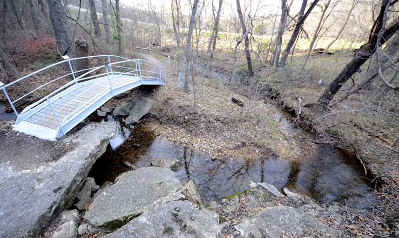
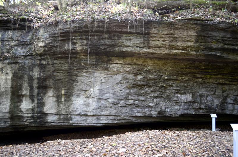
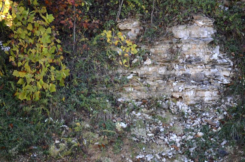
2 During the 2011 fall semester, student team members encountered a challenge while trying to complete a field trip at Tanyard Creek Nature Trail in Bella Vista. The class meets each Tuesday at 6 p.m. to accommodate students that work, and by the time we arrived at the site, it was too dark to see within a matter of minutes. The field trip was rescheduled for a different time, but some students had conflicts because of the many other obligations of a community-college student. So our team decided to create a web-based fieldtrip to help students that could not attend the class trip, complete their work. The first stop on the field trip is a bridge that crosses Avalon Branch, a small stream that merges into Tanyard Creek farther along the trail. This river is fed by surface water runoff, springs, and the spillway from Lake Avalon that is located across Arkansas 340 from site A. The Lake was built during the development of Bella Vista by Cooper Communities in the late 1960s for recreation purposes. The lake was built along an existing Avalon Branch river system that now feeds the lake and continues to this location today. (Fite, 1993) The purpose of this site A exercise is to identify components of the topography: channel walls, flood plain, direction and speed of flow, gravel and sand bars learned about in the text as well as concepts introduced in the field such as riffles. Photographs of the area were taken to be included in the Web site that could show students the location of the gravel bar, undercutting of the bank, and give the students an understanding of the processes that take place in the meandering stream. The undercutting occurs near the outside of the stream as the maximum velocity of the stream is shifted to the outside through inertia. As this happens the velocity at the inside of the curve decreases and causes deposition of the gravel bar. (Charles C. Plummer, 2010) The second stop on the field trip lands the student on a gravel bar in front of a limestone bluff. The limestone bluff is exposed and there are limestone gravel that holds many fossils on the gravel.
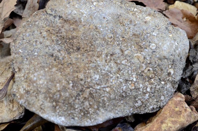
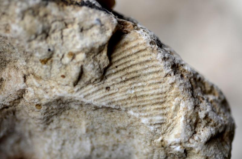
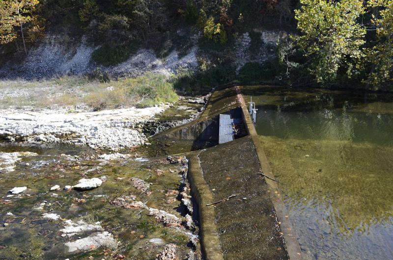
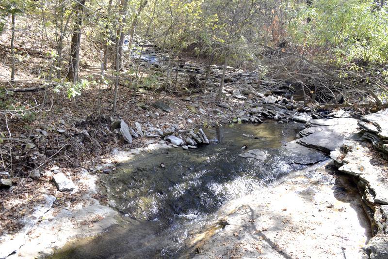
3 Although in the photographs it is difficult to see under the bluff, there is water underneath that in wetter times, flows into the Avalon Branch. Some of the fossils recovered on the gravel bar are identified as brachiopod and crinoid fossils. The crinoids were a group of marine vertebrates. Most of today s living forms are stemless and live in clear shallow water down to about 200 meters. The source adds that Crinoids are most common in Paleozoic rocks worldwide and in Arkansas are abundant in Late Ordovician and Mississippian age rocks. (Invertebrate Fossils) Brachiopods were soft-bodied marine animals enclosed in a shell, resembling clams. These animals were very abundant during the Paleozoic but gradually gave way to clams. Consequently, brachiopods are common in Paleozoic rocks of Arkansas, whereas clams are far more common in younger rocks. (Invertebrate Fossils) From the discovery of these two fossils, we can estimate the age of the rocks from 460 to 320 million years ago. And we can also see that at that time, our area would have been a marine environment. (GSA Geologic Time Scale) The third location, site C, that we visited on the fieldtrip was the spillway from Lake Windsor that feeds Tanyard Creek. The spillway was constructed in the 1970 s as development of Bella Vista continued. (Morgan, 2011) This was again built to dam an existing stream and the spillway was placed where the water naturally flowed. The purpose of this lake was and continues to be recreation. One of the first things that students notice about the spillway is the deeper channel that leads away from the spillway toward the waterfall. It was there before the dam was built in the 1970s, according to Clem Morgan, Recreation Manager with the Bella Vista Property Owners Association. Morgan lived and played near the creek as a child and remembers that formation.
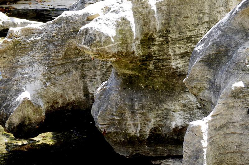
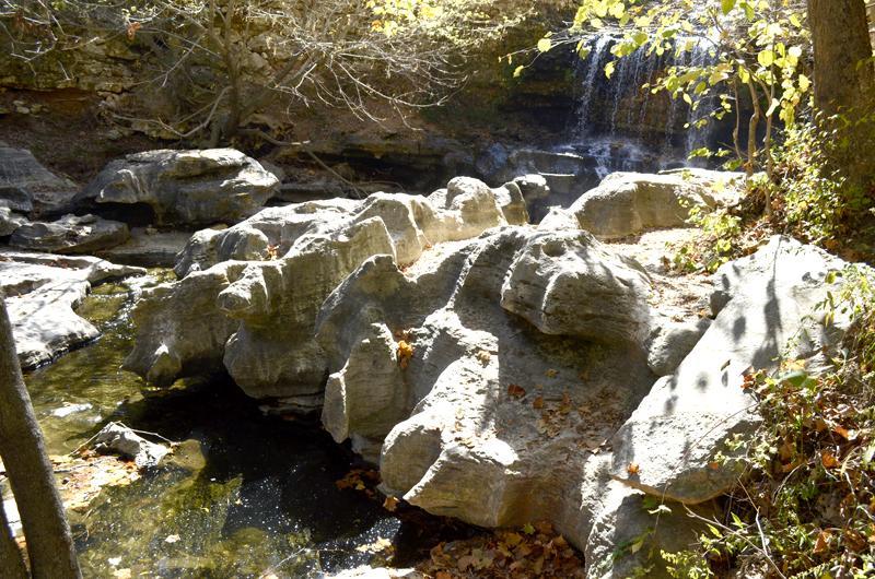
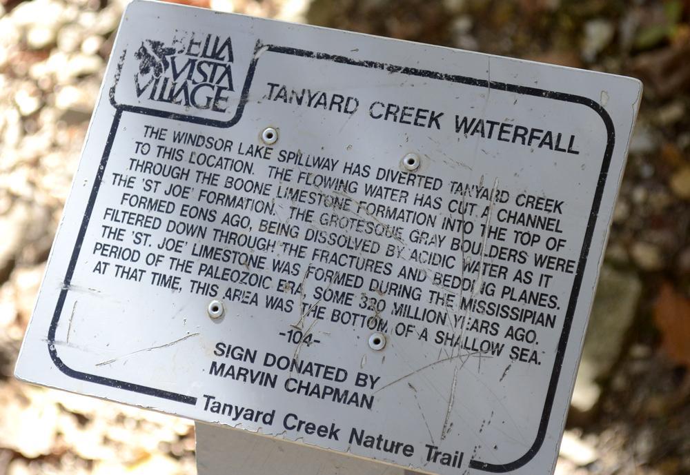
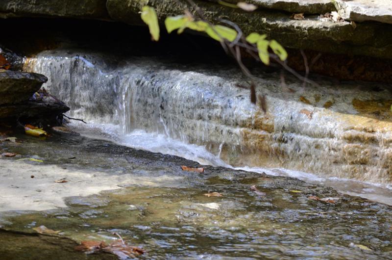
4 Standing on the dam and looking across the spillway, students can notice rock layers that are exposed. These layers are colored differently. The different beds, and the lines called bedding planes that separate them, record changing conditions while sand and mud were being deposited on the sea floor. By studying this layering, geologists learn volumes about the ancient environments in which the sediments were deposited. (Bryant Watershed Project) A creation of the Windsor Lake Spillway, Tanyard Creek Waterfall, or site D, is one of the more eye-catching portions of the trail. The flowing water creates a path through Boone limestone formations which consist primarily of gray, fine- to coarse-grained fossiliferous limestone mixed with chert. The chert is dark in color in the lower portion of the structure and light in the upper portion. The amount of chert varies noticeably both vertically and horizontally. The Boone limestone consists of oolite near the top of the formation. The Boone formation is well known for dissolutional features, such as sinkholes, caves, and enlarged fissures. Crinoids are the most common fossil found in this limestone formation. The St. Joe limestone formation (formed during the Mississippian period of the Paleozoic era) is a fine-grained, crinoid limestone that may occasionally contain some smoothly bedded chert. The limestone is consistently gray, but may also be red, pink, purple, brown, or amber. The fossils are usually white in contrast to the overall conditions. Thin calcareous shales are found in the limestone structure (top, lower middle, and base). The base of the St. Joe Limestone is generally marked by phosphates, which are usually a greenish shale or conglomerate. These enormous gray boulders (great for forming bluffs) have been around for a long time. Site E brings us to the end of the field trip, where students will notice a strong odor coming from the stream. The odor is caused by a sulfur spring that enters the creek on the right side, if you are looking up stream on the bridge. If you walk over the bridge there is a trail that goes upstream a little
5 way and if you look back you will notice a brown and yellow colored area. This is where the sulfur stream is located. The smell can be caused by the weathering of pyrite or other minerals in the rocks. The smell is similar to rotten eggs and is stronger at times depending on weather conditions. This brings our team to the close of the field trip locations. People can continue along the trail to see more natural beauty from Bella Vista, or head back to the parking lot for home. Either way, this is great place to enjoy nature and learn about the Earth.
6 Bibliography Bryant Watershed Project. (n.d.). Stratigraphy: Rock Layering. Retrieved December 3, 2011, from watersheds.org: Charles C. Plummer, D. H. (2010). Physical Geology: Thirteenth Edition. New York: McGraw-Hill. Fite, G. C. (1993). From Vision to Reality: A History of Bella Vista Village, Rogers, Arkansas: RoArk Printing, Inc. GSA Geologic Time Scale. (n.d.). Retrieved December 2, 2011, from The Geological Society of America: Invertebrate Fossils. (n.d.). Retrieved December 2, 2011, from Arkansas Geological Survey: Morgan, C. (2011, December 2). Bella Vista Property Owners Association Recreation Manager. (J. Wedgeworth, Interviewer)

7 Site A photographs
8 Site B Photographs
9
10 Site C Photographs
11 Site D Photographs
12

13 Site E Photographs
14
Fossils and Geology of Litzsinger Road Ecology Center
 Fossils and Geology of Litzsinger Road Ecology Center Table of Content Key Terms 1 Key Terms 2 What you need to know Geologic Map of Missouri Geologic Time Chart More of what you need to know Digital map
ADVENTURES IN WATER DEVELOPED BY LOUISVILLE WATER COMPANY
 ADVENTURES IN WATER DEVELOPED BY LOUISVILLE WATER COMPANY Tunneling for Water explains the science behind a first-of-its-kind project in the world! Louisville Water Company is the first water utility
GY 111 Lecture Note Series Sedimentary Environments 2: Rivers and Deltas
 GY 111 Lecture Notes D. Haywick (2008-09) 1 GY 111 Lecture Note Series Sedimentary Environments 2: Rivers and Deltas Lecture Goals A) Rivers and Deltas (types) B) Water Flow and sedimentation in river/deltas
Maine Geologic Facts and Localities October, Lobster Lake, Maine. Text by Robert G. Marvinney. Maine Geological Survey
 Maine Geologic Facts and Localities October, 1998 Lobster Lake, Maine 45 o 51 7.91 N, 69 o 30 53.88 W Text by Robert G. Marvinney, Department of Agriculture, Conservation & Forestry 1 Map by Introduction
LBJWC - Sinkhole Lesson
 LBJWC - Sinkhole Lesson Concept Caves and sinkholes are major openings in the ground that recharge water to the Edwards Aquifer. Objective - Students will: 1) identify a sinkhole, cave, fracture, fault,
EPS 50 Lab 4: Sedimentary Rocks
 Name: EPS 50 Lab 4: Sedimentary Rocks Grotzinger and Jordan, Chapter 5 Introduction In this lab we will classify sedimentary rocks and investigate the relationship between environmental conditions and
Erosion Surface Water. moving, transporting, and depositing sediment.
 + Erosion Surface Water moving, transporting, and depositing sediment. + Surface Water 2 Water from rainfall can hit Earth s surface and do a number of things: Slowly soak into the ground: Infiltration
Geotechnical Aspects of the Ohio River Bridges Project
 Geotechnical Aspects of the Ohio River Bridges Project Mark A. Litkenhus, PE Sr. Geotechnical Engineer Stephen H. Bickel, PE Sr. Geotechnical Engineer STGEC Ohio River Bridges at Louisville Geotechnical
Geological History of the Grand Canyon
 Geological History of the Grand Canyon For a copy of this assignment, print a copy of this web page. The Project Your job is to write a short paper that describes the geological history of the Grand Canyon
Writing Earth s History
 Earths History Writing Earth s History How is Earths History like writing in your Journal? Everyday, something happens and, with a pen, it is written down in the pages of your journal. As you continue,
The Niagara Escarpment extends from western New York, through the GTA all the way up to Manitoulin Island and into Michigan and Wisconsin.
 is southern Ontario s most prominent topographic feature, extending more than 500 kilometres from western New York, through Niagara Falls and the western part of the Greater Toronto Area (GTA), and north
GIFFORD PINCHOT STATE PARK DIABASE (MOLTEN LIQUID ROCK)
") PENNSYLVANIA TRAIL OF GEOLOGY PARK GUIDE 10 GIFFORD PINCHOT STATE PARK DIABASE (MOLTEN LIQUID ROCK) Gifford Pinchot State Park contains examples of the three major rock classes: igneous, metamorphic, and
PENNSYLVANIA TRAIL OF GEOLOGY PARK GUIDE 10 GIFFORD PINCHOT STATE PARK DIABASE (MOLTEN LIQUID ROCK) Gifford Pinchot State Park contains examples of the three major rock classes: igneous, metamorphic, and
Week 4/5: Limestone & Rock ages
 Week 4/5: Limestone & Rock ages Monday Warm Up: Write two things you still need to finish in order to be prepared for your presentation tomorrow. LT: I can make a presentation about my solution to a science
Lab 7: Sedimentary Structures
 Name: Lab 7: Sedimentary Structures Sedimentary rocks account for a negligibly small fraction of Earth s mass, yet they are commonly encountered because the processes that form them are ubiquitous in the
Field Trip Number One. By: Pat Dryer. Geography 360
 Field Trip Number One By: Pat Dryer Geography 360 Table of Contents Introduction. Page 1 Stop One... Page 2 Stop Two... Page 4 Stop Three... Page 5 Stop Four... Page 7 Bibliography Page 8 Campus Map Source:
Sedimentary Rocks. Origin, Properties and Identification. Physical Geology GEOL 101 Lab Ray Rector - Instructor
 Sedimentary Rocks Origin, Properties and Identification Physical Geology GEOL 101 Lab Ray Rector - Instructor Sedimentary Rock Origin and Identification Lab Pre-Lab Internet Link Resources 1) http://www.rockhounds.com/rockshop/rockkey/index.html
Cattaraugus Creek: A Story of Flowing Water and the Geology of the Channel It Flows Through Presentation to West Valley Citizen Task Force 4/27/16
 Cattaraugus Creek: A Story of Flowing Water and the Geology of the Channel It Flows Through Presentation to West Valley Citizen Task Force 4/27/16 Raymond C. Vaughan, Ph.D. What happens if you drop a
test date Name date Review: Geologic Time & Geologic Procesess-: You will record 1-38 answers on the scan sheet! These are worth 1.
 Review: Geologic Time & Geologic Procesess-: You will record 1-38 answers on the scan sheet! These are worth 1.5 points each Use your EARTH HISTORY CHART Part I. Matching All of the statements match to
Devil s Punchbowl -Virtual Field Trip-
 Devil s Punchbowl -Virtual Field Trip- School of GEOGRAPHY & GEOLOGY Carolyn Eyles & Susan Vajoczki Prepared by Zachary Windus and Liz Kenny From McMaster University take Main Street West towards Ancaster.
Earth History: Record in the Rocks
 Earth History: Record in the Rocks The geologic history of Earth can be read from rocks if you know what to look for. In this presentation, you will see examples of many types of clues, stored in rocks.
GEOLOGICAL AGE OF ROCKS. Absolute geological age
 GEOLOGICAL AGE OF ROCKS Absolute geological age The pioneer of nuclear physics discovered at the turn of centuries that atoms of certain elements, the radioactive ones, spontaneously disintegrate to form
mountain rivers fixed channel boundaries (bedrock banks and bed) high transport capacity low storage input output
 high transport capacity low storage input output") mountain rivers fixed channel boundaries (bedrock banks and bed) high transport capacity low storage input output strong interaction between streams & hillslopes Sediment Budgets for Mountain Rivers Little
mountain rivers fixed channel boundaries (bedrock banks and bed) high transport capacity low storage input output strong interaction between streams & hillslopes Sediment Budgets for Mountain Rivers Little
Some Geological Features at Smalls Falls, Maine
 Maine Geologic Facts and Localities July, 2005 Some Geological Features at Smalls Falls, Maine 44 51 30.47 N, 70 30 58.74 W Text by Robert Marvinney, Department of Agriculture, Conservation & Forestry
Sedimentary Rocks. Origin, Properties and Identification. Geology Laboratory GEOL 101 Lab Ray Rector - Instructor
 Sedimentary Rocks Origin, Properties and Identification Geology Laboratory GEOL 101 Lab Ray Rector - Instructor Sedimentary Rock Origin and Identification Lab Pre-Lab Internet Link Resources 1) http://www.rockhounds.com/rockshop/rockkey/index.html
Cretaceous, Dakota Formation, Terra Cotta Member South Side of I-70, Salina County, Kansas
 Cretaceous, Dakota Formation, Terra Cotta Member South Side of I-70, Salina County, Kansas Written By: Steven D.J. Baumann G-102010-1A Outcrop looking southeast Photo taken by: Steven Baumann on 10-20-2010
Subsurface Geology of the Kennebec River
 Maine Geologic Facts and Localities July, 1998 Subsurface Geology of the Kennebec River 43 54 40.75 N, 69 48 29.01 W Text by Daniel B. Locke, Department of Agriculture, Conservation & Forestry 1 Map by
Module 10: Resources and Virginia Geology Topic 4 Content: Virginia Geology Notes
 Virginia is composed of a very diverse landscape that extends from the beaches and barrier islands all of the way to the highly elevated Appalachian Plateau. Geologists have discovered ancient shallow
Chapter 6 Pages of Earth s Past: Sedimentary Rocks
 Chapter 6 Pages of Earth s Past: Sedimentary Rocks Introduction! Drilling into the bottom of the North Sea, we encounter: " Soft mud and loose sand, silt, pebbles, and shells. Then: " Similar materials
The Cycling of Matter. Day 1
 The Cycling of Matter Day 1 Objective I will learn the rock cycle is the series of processes in which rock changes from one form to another. I will learn in the water cycle, water condenses, precipitates
Sediment and sedimentary rocks Sediment
 Sediment and sedimentary rocks Sediment From sediments to sedimentary rocks (transportation, deposition, preservation and lithification) Types of sedimentary rocks (clastic, chemical and organic) Sedimentary
Geo 302D: Age of Dinosaurs. LAB 2: Sedimentary rocks and processes
 Geo 302D: Age of Dinosaurs LAB 2: Sedimentary rocks and processes Last week we covered the basic types of rocks and the rock cycle. This lab concentrates on sedimentary rocks. Sedimentary rocks have special
Different Coloration of Devonian Shales
 The JUNIATA JOURNAL of GEOLOGY, 1, 1-6 (2014) Original Article Different Coloration of Devonian Shales Garrett Lavelle Shale is a sedimentary rock that develops in a deep marine environment. The coloration
Sedimentary rocks. Mechanical Weathering. Weathering. Chemical weathering. Rates of weathering. Fossil Fuel Resources. Two kinds of weathering
 Sedimentary rocks Fossil Fuel Resources Exam next Tuesday February 14 Bring Scantron and Review Questions About 75% of all rock outcrops on the continents Important to reconstruct much of Earth's history
Field Trip 1 Tunnel Mill, Vernon, Indiana: Waldron Shale
 Geol G308 Paleontology and Geology of Indiana Name: Field Trip 1 Tunnel Mill, Vernon, Indiana: Waldron Shale On this trip we will visit Tunnel Mill, which is located just south of Vernon, Indiana in the
GEOL 104 Dinosaurs: A Natural History Geology Assignment. DUE: Mon. Sept. 19
 GEOL 104 Dinosaurs: A Natural History Geology Assignment DUE: Mon. Sept. 19 Part I: Environments of Deposition Geologists can use various clues in sedimentary rocks to interpret their environment of deposition:
BOY SCOUTS GEOLOGY MERIT BADGE
 Requirements highlighted in yellow will be covered at the club show. Merit Badge Counselors will be on-hand. Please bring your own paperwork. Children under 12 and scouts in uniform are admitted to the
Sedimentary Rocks. Origin, Properties and Identification. Physical Geology GEOL 100. Ray Rector - Instructor
 Sedimentary Rocks Origin, Properties and Identification Physical Geology GEOL 100 Ray Rector - Instructor Sedimentary Rock Origin and Identification Lab Pre-Lab Internet Link Resources 1) http://www.rockhounds.com/rockshop/rockkey/index.html
Clyde River Landslide
 Clyde River Landslide Department of Geology, Perkins Hall, University of Vermont, Burlington, VT 05405 Abstract: This paper investigates a landslide on the Clyde River in Newport, Vermont. The landslide
Coso Red Hill and Coso Playa field trip, Prof. Alessandro Grippo, Ph.D.
 HISTORICAL GEOLOGY fall 2016 Professor: Dr. Alessandro Grippo, Ph.D. FIELD TRIP REPORT: Friday, October 21, 2016: Coso Red Hill & Playa, Coso Junction CA YOUR NAME part 1: COSO RED HILL (you can sample
depression above scarp scarp
 1 LAB 1: FIELD TRIP TO McKINLEYVILLE AND MOUTH OF THE MAD RIVER OBJECTIVES: a. to look at geomorphic and geologic evidence for large scale thrust-faulting of young sediments in the Humboldt Bay region
Geology 229 Engineering Geology. Lecture 6. Basic Rock Classification and Engineering Considerations (West, Chs. 2, 3, 4, 5)
") Geology 229 Engineering Geology Lecture 6 Basic Rock Classification and Engineering Considerations (West, Chs. 2, 3, 4, 5) Outline of this Lecture 1. Rock types and rock cycle 2. Geological and engineering
Geology 229 Engineering Geology Lecture 6 Basic Rock Classification and Engineering Considerations (West, Chs. 2, 3, 4, 5) Outline of this Lecture 1. Rock types and rock cycle 2. Geological and engineering
Name: Period: Date: ID: A. Circle the choice that best completes the statement or answers the question and write the letter on the blank.
 Name: Period: _ Date: _ ID: A Unit 7 Practice Circle the choice that best completes the statement or answers the question and write the letter on the blank. 1. What term describes the movement of rock
EROSION, DEPOSITION AND SEDIMENTARY ROCKS. Reading: Earth Science Tarbuck and Lutgens Chapter 5: pages Chapter 3: pages 52-54, 61-69
 EROSION, DEPOSITION AND SEDIMENTARY ROCKS Reading: Earth Science Tarbuck and Lutgens Chapter 5: pages 124-133 Chapter 3: pages 52-54, 61-69 Base Level Resistant bed Resistant bed creates a local base level
Sediment and Sedimentary rock
 Sediment and Sedimentary rock Sediment: An accumulation of loose mineral grains, such as boulders, pebbles, sand, silt or mud, which are not cemented together. Mechanical and chemical weathering produces
Earth Science Chapter 6 Section 2 Review
 Name: Class: Date: Earth Science Chapter 6 Section Review Multiple Choice Identify the choice that best completes the statement or answers the question. 1. Most streams carry the largest part of their
Question #1: What are some ways that you think the climate may have changed in the area where you live over the past million years?
 Reading 5.2 Environmental Change Think about the area where you live. You may see changes in the landscape in that area over a year. Some of those changes are weather related. Others are due to how the
ROCK CLASSIFICATION AND IDENTIFICATION
 Name: Miramar College Grade: GEOL 101 - Physical Geology Laboratory SEDIMENTARY ROCK CLASSIFICATION AND IDENTIFICATION PRELAB SECTION To be completed before labs starts: I. Introduction & Purpose: The
Field trip guide to the Marin Headlands (Golden Gate National Recreation Area) and the Point Reyes National Seashore
 and the Point Reyes National Seashore") Name: Field trip guide to the Marin Headlands (Golden Gate National Recreation Area) and the Point Reyes National Seashore Geology of the National Parks San Francisco State University April 20, 2002 DRIVING
Name: Field trip guide to the Marin Headlands (Golden Gate National Recreation Area) and the Point Reyes National Seashore Geology of the National Parks San Francisco State University April 20, 2002 DRIVING
4. The map below shows a meandering stream. Points A, B, C, and D represent locations along the stream bottom.
 1. Sediment is deposited as a river enters a lake because the A) velocity of the river decreases B) force of gravity decreases C) volume of water increases D) slope of the river increases 2. Which diagram
Ohio s State Tests PRACTICE TEST LARGE PRINT GRADE 8 SCIENCE. Student Name
 Ohio s State Tests PRACTICE TEST LARGE PRINT GRADE 8 SCIENCE Student Name The Ohio Department of Education does not discriminate on the basis of race, color, national origin, sex, religion, age, or disability
Section 7. Reading the Geologic History of Your Community. What Do You See? Think About It. Investigate. Learning Outcomes
 Chapter 3 Minerals, Rocks, and Structures Section 7 Reading the Geologic History of Your Community What Do You See? Learning Outcomes In this section, you will Goals Text Learning Outcomes In this section,
Lecture Outline Wednesday - Friday February 14-16, 2018
 Lecture Outline Wednesday - Friday February 14-16, 2018 Quiz 2 scheduled for Friday Feb 23 (Interlude B, Chapters 6,7) Questions? Chapter 6 Pages of the Past: Sedimentary Rocks Key Points for today Be
Field trip to Racine Reef Complex, Thornton Quarry, Illinois
 Field trip to Racine Reef Complex, Thornton Quarry, Illinois Primary objectives for this fieldtrip 1) Collect and identify the fossils of the Racine Reef Complex. 2) Discuss procedures for collecting fossil
Florida s Changing Shape
 Florida s Changing Shape Background: For much of its history, Florida was underwater. At first, Florida consisted solely of the Florida Platform, a limestone base formed from the calcium carbonate remains
guided notes Work Day WPA Posters!
 Bellringer D4 Get out your guided notes, prepare for the quiz review! Rules: Each table needs at least one device connected to the Kahoot You can help your neighbor during the review Questions are fast;
ESC 1000 (Neuhoff) Assignment #2: Rocks and Tectonics
 Assignment #2: Rocks and Tectonics") 1 ESC 1000 (Neuhoff) Assignment #2: Rocks and Tectonics Name: UF ID: Assignment is due by the beginning of class on Wednesday, October 13. This assignment is worth 45 points towards your final grade. Please
1 ESC 1000 (Neuhoff) Assignment #2: Rocks and Tectonics Name: UF ID: Assignment is due by the beginning of class on Wednesday, October 13. This assignment is worth 45 points towards your final grade. Please
Teacher s Pack Key Stage 3 GEOGRAPHY
 Teacher s Pack Key Stage 3 GEOGRAPHY Geography Key Stage 3 Fieldwork Worksheet Rivers: 1. Is the water fresh or salty? (test its resistance or specific gravity) 2. Do you know where the water is coming
Sedimentary Rocks, our most Valuable Rocks. Or, what you will probably find when you are outdoors exploring.
 Sedimentary Rocks, our most Valuable Rocks Or, what you will probably find when you are outdoors exploring. Sedimentary rocks give us evidence to earth s earlier history. We look at processes happening
Lecture Outlines PowerPoint. Chapter 13 Earth Science 11e Tarbuck/Lutgens
 Lecture Outlines PowerPoint Chapter 13 Earth Science 11e Tarbuck/Lutgens 2006 Pearson Prentice Hall This work is protected by United States copyright laws and is provided solely for the use of instructors
Later Mississippian. Sun, seas, and reefs
 Later Mississippian Sun, seas, and reefs P. David Polly Department of Geological Sciences Indiana University Bloomington, Indiana 47405 USA pdpolly@indiana.edu Bahama Banks Space shuttle photo by Chris
Ohio s State Tests PRACTICE TEST GRADE 8 SCIENCE. Student Name
 Ohio s State Tests PRACTICE TEST GRADE 8 SCIENCE Student Name The Ohio Department of Education does not discriminate on the basis of race, color, national origin, sex, religion, age, or disability in employment
General Geology Lab #4: Sedimentary Rocks and Environments
 Name General Geology Lab #4: Sedimentary Rocks and Environments Please identify the following group of sedimentary rocks. Please determine whether they clastic, biogenic or chemical. Also, answer the sample
SEDIMENTARY ROCKS. When mountains are first formed, they are tall and jagged like the Rocky Mountains on the west coast of North America.
 SEDIMENTARY ROCKS When mountains are first formed, they are tall and jagged like the Rocky Mountains on the west coast of North America. Over time (millions of years) mountains become old mountains like
Earth s Changing Surface Chapter 4
 Name Hour Due Date Earth s Changing Surface Chapter (You do not need your book) Page 1 Fossils Summary Page 2 Traces of Tracks Page 3 Finding the Relative Age of Rocks Summary. Page - Finding the Relative
Objectives: Define Relative Age, Absolute Age
 S6E5. Students will investigate the scientific view of how the earth s surface is formed. c. Classify rocks by their process of formation. g. Describe how fossils show evidence of the changing surface
The Nature of Sedimentary Rocks
 The Nature of Sedimentary Rocks Sedimentary rocks are composed of: Fragments of other rocks Chemical precipitates Organic matter or biochemically produced materials The Nature of Sedimentary Rocks Sedimentary
Lab 2 Geological Time and Fossil Samples
 Geol G308 Paleontology and Geology of Indiana Name: Lab 2 Geological Time and Fossil Samples This lab has two components: understanding geological time scales and choosing fossil samples from the IU Paleontology
What is weathering and how does it change Earth s surface? Answer the question using
 7 th Grade Lesson What is weathering and how does it change Earth s surface? Answer the question using the sentence frame. You have 4 minutes. Weathering is. This changes the Earth s surface because. 1
Figure 1 The map shows the top view of a meandering stream as it enters a lake. At which points along the stream are erosion and deposition dominant?
 1. In which type of climate does chemical weathering usually occur most rapidly? 1. hot and dry 3. cold and dry 2. hot and wet 4. cold and wet 2. Figure 1 The map shows the top view of a meandering stream
MOR SEAWAY TEACHERS. A CHANGING LANDSCAPE Activity Overview BIG IDEA
 MOR SEAWAY 03 Activity Overview BIG IDEA The Earth and its landscapes change over time. Scientists use the fossil record to understand the Earth s environments and climates millions of years ago. OBJECTIVE
The Geology of Sebago Lake State Park
 Maine Geologic Facts and Localities September, 2002 43 55 17.46 N, 70 34 13.07 W Text by Robert Johnston, Department of Agriculture, Conservation & Forestry 1 Map by Robert Johnston Introduction Sebago
17-1 The Fossil Record Slide 1 of 40
 1 of 40 Fossils and Ancient Life Fossils and Ancient Life Paleontologists are scientists who collect and study fossils. All information about past life is called the fossil record. The fossil record includes
Depositional Environment
 Depositional Environment Sedimentary depositional environment describes the combination of physical, chemical and biological processes associated with the deposition of a particular type of sediment. Types
Sediments and Sedimentary Rocks
 Sediments and Sedimentary Rocks (Shaping Earth s Surface, Part 2) Science 330 Summer 2005 What is a sedimentary rock? Products of mechanical and chemical weathering Account for about 5 percent of Earth
C E C U R R I C U L U M I E N S C B L E I T A. i N T E G R A T I N G A R T S i n O N A T I D U C B L I P U. Student Learning Objectives:
 Sedimentation E Q U I T A B L E S C I E N C E C U R R I C U L U M Lesson 3 i N T E G R A T I N G A R T S i n P U B L I C E D U C A T I O N NGSS Science Standard: 4-ESS1-1 Identify evidence from patterns
Sedimentary Rocks. All sedimentary rocks begin to form when existing rocks are broken down into sediments Sediments are mainly weathered debris
 Rocks! Objectives Describe the major processes involved in the formation of sedimentary rock Distinguish between clastic sedimentary rocks and chemical sedimentary rocks Identify the features that are
Directed Reading. Section: Precambrian Time and the Paleozoic Era EVOLUTION. beginning of life is called. to. PRECAMBRIAN TIME.
 Skills Worksheet Directed Reading Section: Precambrian Time and the Paleozoic Era 1. Where is the geologic history of Earth recorded? 2. What kind of information can scientists get from the types of rock
Sedimentary Rocks - are one of the three main rock types
 Today s Objective: What Makes Sedimentary Rocks Special? Sedimentary Rocks - are one of the three main rock types A sedimentary rock can form one of three ways: 1. by the deposition of the weathered remains
FOSSILS IN YOUR BACKYARD
 MOR BACKYARD 12 Activity Overview BIG IDEA OBJECTIVE BACKGROUND Millions of years ago, dinosaurs roamed all over our planet Why is it then that we only find dinosaurs in certain geographical locations?
NC Earth Science Essential Standards
 NC Earth Science Essential Standards EEn. 2.1 Explain how processes and forces affect the Lithosphere. EEn. 2.1.1 Explain how the rock cycle, plate tectonics, volcanoes, and earthquakes impact the Lithosphere.
What are the different ways rocks can be weathered?
 Romano - 223 What are the different ways rocks can be weathered? Weathering - the breakdown of rocks and minerals at the Earth s surface 1. 2. PHYSICAL WEATHERING Rock is broken into smaller pieces with
Surface Water and Stream Development
 Surface Water and Stream Development Surface Water The moment a raindrop falls to earth it begins its return to the sea. Once water reaches Earth s surface it may evaporate back into the atmosphere, soak
Tell me what the word aggregate means and at least three things aggregate is used to make.
 Lesson Plan Scout s Geology Objective: After today s lesson, you will be able to Tell me what the word aggregate means and at least three things aggregate is used to make. List the steps in the mining
A Geological Tour of Tumbledown Mountain, Maine
 Maine Geologic Facts and Localities April, 1998 A Geological Tour of Tumbledown Mountain, Maine 44 45 3.21 N, 70 32 50.24 W Text by Robert G. Marvinney, Department of Agriculture, Conservation & Forestry
TRACE FOSSIL FOSSIL ICE CORE RELATIVE DATING SUPERPOSITION ABSOLUTE DATING GEOLOGIC COLUMN UNIFORMITARIANISM HALF-LIFE RADIOACTIVE DECAY
 THIS IS NOT THE SAME TEST. YOU MUST ANSWER ALL QUESTIONS. NAME: Bubble the circle below U3L1 Write the letter next to the vocab term VOCAB MATCH 1 A. O B. O C. O D. O 1 2 A. O B. O C. O D. O 2 3 A. O B.
KRIS wsbssm. IBHiiilll
 KRIS wsbssm IBHiiilll Digitized by the Internet Archive in 2012 with funding from University of Illinois Urbana-Champaign http://archive.org/details/engineeringaspec34ekbl STATE OF ILLINOIS HENRY HORNER,
Illustrations of Selected Ordovician fossils
 Illustrations of Selected Ordovician fossils Appendix 1 Brachiopods Cephalopods Brachiopods (brack'-i-oh-pods) are a group of marine animals with two shells. They all have an upper and lower shell. The
Mammoth Cave National Park, Kentucky
 Mammoth Cave National Park, Kentucky Objectives of Today s Lecture Refresher on Sedimentary Depositional Systems and Rock Classifications Transgressive and Regressive Marine Environments Carbonate Depositional
Erosional Features. What processes shaped this landscape?
 Have you ever looked at the land around you and wondered what processes shaped what you see? Perhaps you see mountains, valleys, rivers, or canyons. Do you know how long these geologic features have been
2 Igneous Rock. How do igneous rocks form? What factors affect the texture of igneous rock? BEFORE YOU READ. Rocks: Mineral Mixtures
 CHAPTER 4 2 Igneous Rock SECTION Rocks: Mineral Mixtures BEFORE YOU READ After you read this section, you should be able to answer these questions: How do igneous rocks form? What factors affect the texture
Feet. Cape May Core #51 Start depth: 240 ft Stop depth: 245 ft Recovery (ft): 5.1 ft Date: 3/21/94 Described by: JVB, KGM, CL. 5.
: 5.1 ft Date: 3/21/94 Described by: JVB, KGM, CL. 5.") SAND; medium to fine sand with abundant silt, homogenous slightly mottled appearance; mica on outside, mostly quartz; few darks; peat layer.9 - ft; cnv - same as above; the last few cores are all the same;
SAND; medium to fine sand with abundant silt, homogenous slightly mottled appearance; mica on outside, mostly quartz; few darks; peat layer.9 - ft; cnv - same as above; the last few cores are all the same;
SCI-5 KES 5.7 Geology Post-test Exam not valid for Paper Pencil Test Sessions
 SCI-5 KES 5.7 Geology Post-test Exam not valid for Paper Pencil Test Sessions [Exam ID:1D5NLH 1 Earth's crust is made of plates that move slowly. This movement changes the appearance of the Earth's crust
GEOL.3250 Geology for Engineers Sedimentary & Metamorphic Rocks
 GEOL.3250 Geology for Engineers Sedimentary & Metamorphic Rocks Name I. Introduction The bulk of the earth's crust is composed of relatively few minerals. These can be mixed together, however, to give
Geology Merit Badge Workbook
 Merit Badge Workbook This workbook can help you but you still need to read the merit badge pamphlet. This Workbook can help you organize your thoughts as you prepare to meet with your merit badge counselor.
Summer 2014 Reading the Geologic History of Doheny State Beach Rodger More LAYERS LET S TAKE A TOUR THE BLUFFS
 Summer 2014 Reading the Geologic History of Doheny State Beach Rodger More DSBIA Board Officer and Geologist (retired) LAYERS of sediment and rock are like a book. Formations make up chapters and individual
Rock cycle diagram. Principle of Original Horizontality. Sediment is deposited horizontally
 Geologic Time Rock cycle diagram Leaves of History Chapter 21 Lateral Continuity Principle of Original Horizontality Sediment is deposited horizontally Principle of Superposition Oldest rock A Younger
Bryce Canyon. Bryce Zion
 Bryce Canyon Located ~50 mi NE of Zion in southern Utah On Paunsaugunt Plateau: Wetter and Colder than Zion Bounded by Sevier Fault to west and Paunsaugunt Fault to east Rocks are ~100 Ma older than at
Sandy Point Beach, Cousins Island, Yarmouth, Maine
 Maine Geologic Facts and Localities April, 2008 Sandy Point Beach, Cousins Island, Yarmouth, Maine 43 o 46 25.46 N, 70 o 8 44.84 W Text by Tom Weddle, Department of Agriculture, Conservation & Forestry
3/28/08 EB14 Recommendations
 3/28/08 EB14 Recommendations Recommendations for Wayside Integration Strip Version 1 revise markers along the timeline so visitors don t try to establish a one-to-one correspondence with the real trail
Geology 109L Lab 3: Modern Sedimentary Environments --Field Trip to Bodega Bay--
 Geology 109L Lab 3: Modern Sedimentary Environments --Field Trip to Bodega Bay-- Goal: The purpose of this lab is to recognize characteristics of modern sedimentary environments, which will aid you in