Geology 109L Lab 3: Modern Sedimentary Environments --Field Trip to Bodega Bay--
|
|
|
- Patrick Nicholson
- 6 years ago
- Views:
Transcription
1 Geology 109L Lab 3: Modern Sedimentary Environments --Field Trip to Bodega Bay-- Goal: The purpose of this lab is to recognize characteristics of modern sedimentary environments, which will aid you in your interpretation of ancient sedimentary environments as they are preserved in the rock record. This is your opportunity to apply everything that you have learned about sedimentary particles and sedimentary structures (Labs 1 and 2) and how they reflect depositional processes. At the end of the lab you will have a collection of sediment samples and a photo journal that documents geologic features and processes that you observed. You will need: Field notebook, grain size card, hand lens, camera (1 for each group of two or three), trowel for digging (1 for each group of two or three). Depending on the weather, bring warm, water-proof clothing or sunscreen. Rubber boots are nice to keep your feet dry. In the field: While we are in the field, your job will be to collect multiple sediment samples (3-5) from three localities that we will visit, and describe the context in which you found them. The suite of samples that you collect should capture the diversity of local depositional environments. To put the sediment sample in context and determine how the environment changes through time, dig a small hole and look at the deeper sediment layers. A sketch in your field notebook of where each sample was collected relative to the others may be useful. Start thinking about the differences in texture and composition between samples at each locality. Each sample description should include: 1) A sample ID (such as BH-1 for the first sample collected from Bodega Head). 2) Where it was collected (in the breaker zone, in a tidal channel, in a sand dune, etc.). 3) Any sedimentary structures that you observed, including a cross-section sketch if relevant, and how the sediment texture and composition changes with depth. 4) An interpretation of the flow conditions (energy, variability in flow, current direction, etc.) that deposited the sediment you will keep thinking about this back in the lab 5) A log of photos that you take of the environment, sedimentary structures, changes in grain size with depth and laterally **At localities where we are not collecting sediment samples, e.g. Horseshoe Cove, note general characteristics of the depositional environment, and photo document and describe different geologic processes and features for your photo journal. More on the photo journal: Throughout the day take photos of different geologic features and processes. At the end of the day you should have at least 20 photos. Don t forget to record in your field notebook what you took a picture of, and make sure to have something in your photo for scale! You will identify 1

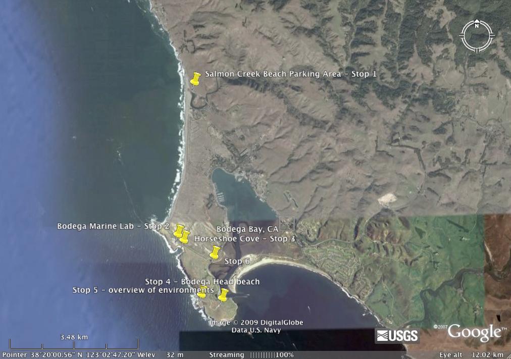
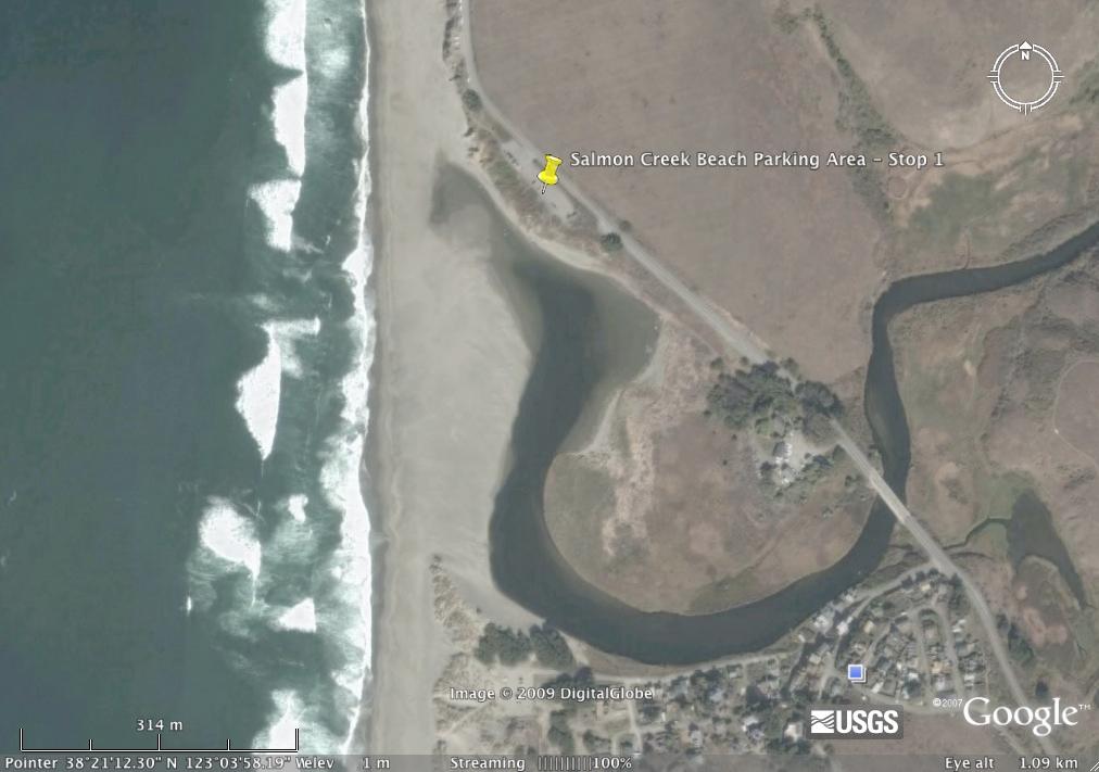
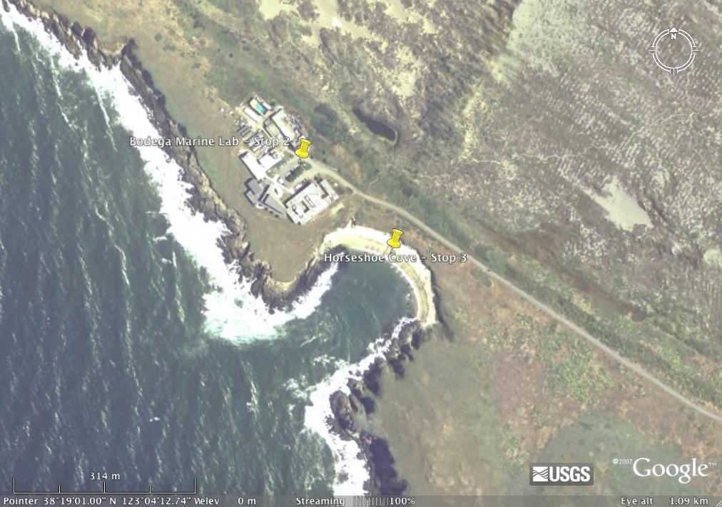
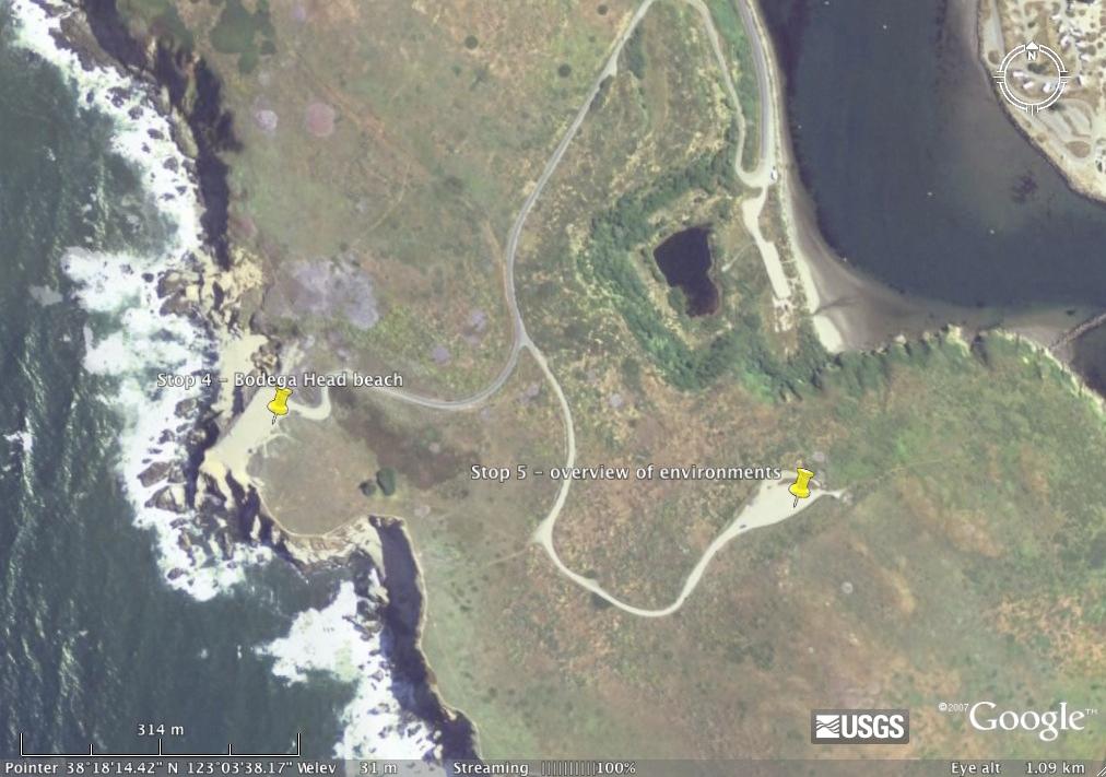
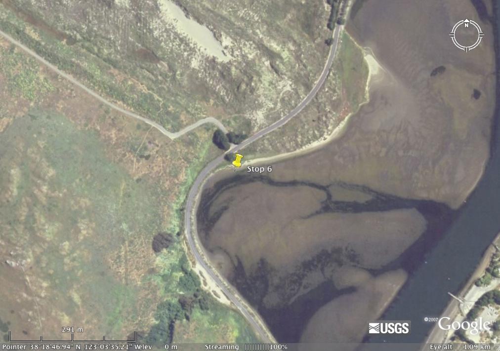
2 and describe the photos, and use drawing features in MS Word to label features on your photos, such as ripples, current direction, variable sorting of sediment, etc. Make sure that you are not just taking photos of scenery and trying to identify things. Take each picture with a purpose, and think about whether or not you are documenting the feature in its geologic context. Keeping a Field Notebook The field notebook is the original scientific record of your observations and is one of the most important items for any geologist. Organizing your notes systematically as you take them will help you when you refer back to your notes. Each entry in your field notebook should include first the date, time and locality. Table 2.1 (page 16) in Sedimentary Rocks in the Field provides a good summary of information to include as part of your sedimentological observations. Field sketches can be very useful, and should focus on the features of interest, rather than things like vegetation. Make sure to include a scale for any sketches. In the lab: Describe the texture and composition of each sediment sample you collected, as you did in Lab 1. Give the relative abundances of each grain composition, overall grain size, shape, sorting, and textural maturity. Field Trip Stops: Stop 1 Salmon Creek Beach Collect sediment samples along a transect perpendicular to the shoreline from the water s edge to the inland margin of the beach and describe the environment where they are deposited. Take pictures for your photo journal. Lunch at Bodega Marine Lab Stop 2 Horseshoe Cove Compare the texture and composition of the sediment here with the sediment at Salmon Creek Beach, and describe your observations in your field notebook. Take pictures for your photo journal. Stop 3 Bayside Park Collect a sample of sediments from the Bay. Observe and describe how these sediments are different from the beach sands at Salmon Creek and Horseshoe Cove. Pictures! Stop 4 Bodega Head Compare the sediments deposited at Bodega Head with sediments from Salmon Creek and Horseshoe Cove. Collect a sample of the weathered bedrock and of the beach sediment. Pictures! 2
3 What you will hand in: 1. Your field notebook. 2. A mini-report that summarizes your observations and interpretations and includes as appendices: a. A sediment description (texture and composition) for each sediment sample. b. Your photo journal 1 per group of 2 or 3 is fine since you are sharing cameras. Mini-report: Put together all of the information that you have collected and write a well organized mini-report that summarizes the depositional environment and processes at each locality based on data and observations. Include your description of each sediment sample, and a summary the processes that contributed to its development and deposition. Include a discussion of variability in grain size, sorting, sedimentary structures, and maturity between samples. Also compare the beach sediment from Bodega Beach with the sediment at Bodega Head, and discuss what may be responsible for the observed differences. Refer to your photos and your sediment descriptions in your report, and include these as data appendices. Questions to consider: How does the grain size change along a transect across Salmon Creek beach? How do grain size changes reflect the depositional processes and flow energy? (Hint: explain WHY the energy changes as it does.) How does grain size correlate with sedimentary structures observed where each sample was collected? How does sediment texture vary with depth in each location and between locations? Do certain sedimentary structures occur more commonly in different deposition settings? Under different energy conditions? How does the sorting vary at the different localities? Interpret sediment sorting based on depositional processes. Based on the composition of grains from Salmon Creek Beach, Horseshoe Cove, and Bodega Head, what is a likely source of grains at each beach? Why does it vary. 3

4 Driving Directions from Davis, CA to Bodega Bay, CA 1/24/08 4:43 PM Start: End: Davis, CA US Bodega Bay, CA US Notes: Only text visible within note field will print. Directions Distance Total Est. Time: 1 hour, 56 minutes Total Est. Distance: miles 1: Start out going WEST on 3RD ST toward F ST. 0.1 miles 2: Turn LEFT onto E ST. 0.1 miles 3: E ST becomes RICHARDS BLVD. 0.1 miles 4: Merge onto I-80 W toward SAN FRANCISCO miles 5: Merge onto CA-37 W toward SAN RAFAEL miles 6: Merge onto US-101 N toward SANTA ROSA / EUREKA miles 7: Take the CA-116 E exit toward SONOMA / NAPA. 0.2 miles 8: Turn RIGHT onto LAKEVILLE HWY / CA-116. Continue to follow CA miles 9: CA-116 becomes LAKEVILLE ST. 0.9 miles 10: Turn LEFT onto E WASHINGTON ST. 0.6 miles 11: E WASHINGTON ST becomes BODEGA AVE. 7.9 miles 12: BODEGA AVE becomes VALLEY FORD RD miles 13: Turn SLIGHT LEFT onto CA-1 / VALLEY FORD CUTOFF. Continue to follow CA miles 14: Turn SLIGHT RIGHT onto WINDY LN. 0.1 miles 15: End at Bodega Bay, CA US &2y=US&rsres=1&ms= street Page 1 of 3


5 Driving Directions from Davis, CA to Bodega Bay, CA 1/24/08 4:43 PM Start: Davis, CA US End: Bodega Bay, CA US All rights reserved. Use Subject to License/Copyright These directions are informational only. No representation is made or warranty given as to their content, road conditions or route usability or expeditiousness. User assumes all risk of use. MapQuest and its suppliers assume no responsibility for any loss or delay resulting from such use &2y=US&rsres=1&ms= street Page 3 of 3
6
7
8
9
10
depression above scarp scarp
 1 LAB 1: FIELD TRIP TO McKINLEYVILLE AND MOUTH OF THE MAD RIVER OBJECTIVES: a. to look at geomorphic and geologic evidence for large scale thrust-faulting of young sediments in the Humboldt Bay region
Field Trip Workbook G200 Field Studies Sec 001 (Mt St. Helens north) Fall, 2018 Professor in charge: Alex Ruzicka TA : Secana Goudy
 Fall, 2018 Professor in charge: Alex Ruzicka TA : Secana Goudy") Field Trip Workbook NAME: G200 Field Studies Sec 001 (Mt St. Helens north) Fall, 2018 Professor in charge: Alex Ruzicka TA : Secana Goudy Use this workbook to answer the following questions about the geology
Field Trip Workbook NAME: G200 Field Studies Sec 001 (Mt St. Helens north) Fall, 2018 Professor in charge: Alex Ruzicka TA : Secana Goudy Use this workbook to answer the following questions about the geology
Coso Red Hill and Coso Playa field trip, Prof. Alessandro Grippo, Ph.D.
 HISTORICAL GEOLOGY fall 2016 Professor: Dr. Alessandro Grippo, Ph.D. FIELD TRIP REPORT: Friday, October 21, 2016: Coso Red Hill & Playa, Coso Junction CA YOUR NAME part 1: COSO RED HILL (you can sample
GEOL 02 Lab 9 Field Trip III Centerville Stratigraphic Section Name: Date:
 Name: Date: Team Name: Team Members: Our goal today is to describe the sedimentary lithostratigraphic section of exposed bedrock along the road near Centerville Beach, interpret the depositional environment,
Chapter 6. Field Trip to Sandia Mountains.
 University of New Mexico Biology 310L Principles of Ecology Lab Manual Page -40 Chapter 6. Field Trip to Sandia Mountains. Outline of activities: 1. Travel to Sandia Mountains 2. Collect forest community
Geology and Natural Resources
 Geology and Natural Resources Brought to you by: Western Michigan University Department of Geosciences and The Michigan Geological Repository for Research and Education s K-12 Outreach Program Core Kids
Today we are on a Metamorphic Mystery. To solve your mystery, you must follow the clues and complete the activities on this printable disk.
 Hey there Mini Me Geologists! Today we are on a Metamorphic Mystery. To solve your mystery, you must follow the clues and complete the activities on this printable disk. First, read about each of the samples
ADVENTURES IN WATER DEVELOPED BY LOUISVILLE WATER COMPANY
 ADVENTURES IN WATER DEVELOPED BY LOUISVILLE WATER COMPANY Tunneling for Water explains the science behind a first-of-its-kind project in the world! Louisville Water Company is the first water utility
NAME: GEL 109 Final Study Guide - Winter 2008 Questions 6-24 WILL be on the final exactly as written here; this is 60% of the test.
 GEL 109 Final Study Guide - Winter 2008 Questions 6-24 WILL be on the final exactly as written here; this is 60% of the test. 1. Sketch a map view of three types of deltas showing the differences in river,
**Try not to approach the reserve from the northwest. It may be difficult to do a left turn into the reserve.
 Bolsa Chica Ecological Reserve In the event of threatening weather, students planning to attend should call (909) 869-4055 between 6:30 am and 7:30 am, and listen to the recorded message. Students who
Rock Layers Lab
 Rock Layers Lab Name: 4th grade PSI Science - - - - - - - - - - - - - - - - - - - - - - - - - - - - - - - - - - - - - - - - - - - - - - - - Experiment Questions How are different sediments deposited differently?
Draft exercise for share fair at Bozeman workshop only. This exercise is not ready for distribution. Please send helpful suggestions to
 Draft exercise for share fair at Bozeman workshop only. This exercise is not ready for distribution. Please send helpful suggestions to foleyd@plu.edu Figure list 1. Trailer photograph 2. Location map
NAME: GEL 109 Final Winter 2010
 GEL 109 Final Winter 2010 1. The following stratigraphic sections represents a single event followed by the slow accumulation of background sedimentation of shale. Describe the flows that produced the
Writing Earth s History
 Earths History Writing Earth s History How is Earths History like writing in your Journal? Everyday, something happens and, with a pen, it is written down in the pages of your journal. As you continue,
Jackfork Group research project. What I want them to do:
 Jackfork Group research project What I want them to do: 1. Make observations on the rock types encountered in the JFG units. 2. Make basic interpretations of processes based on these observations. 3. Make
Name: Period: Date: Sedimentary Rock Lab (Formation, Properties, and Ancient Depositional Environments)
") Name: Period: Date: Sedimentary Rock Lab (Formation, Properties, and Ancient Depositional Environments) BIG IDEA: Earth s immense history is recorded in the rocks. Sedimentary rocks tell us about ancient
Name: Period: Date: Sedimentary Rock Lab (Formation, Properties, and Ancient Depositional Environments) BIG IDEA: Earth s immense history is recorded in the rocks. Sedimentary rocks tell us about ancient
Field trip guide to the Marin Headlands (Golden Gate National Recreation Area) and the Point Reyes National Seashore
 and the Point Reyes National Seashore") Name: Field trip guide to the Marin Headlands (Golden Gate National Recreation Area) and the Point Reyes National Seashore Geology of the National Parks San Francisco State University April 20, 2002 DRIVING
Name: Field trip guide to the Marin Headlands (Golden Gate National Recreation Area) and the Point Reyes National Seashore Geology of the National Parks San Francisco State University April 20, 2002 DRIVING
We will provide: hammers (one per group), hard hats, shovels, paper bags or boxes for pebble collections, map boards, and compasses, measuring tapes.
, hard hats, shovels, paper bags or boxes for pebble collections, map boards, and compasses, measuring tapes.") Geology 110 Spring 1999 Northfield Topography and Field Trip to Little Chicago This lab has two parts. After the spot test on the geologic time scale, we will spend the next few hours at a gravel pit near
Geology 110 Spring 1999 Northfield Topography and Field Trip to Little Chicago This lab has two parts. After the spot test on the geologic time scale, we will spend the next few hours at a gravel pit near
Geologic Trips San Francisco and the Bay Area
 Excerpt from Geologic Trips San Francisco and the Bay Area by Ted Konigsmark ISBN 0-9661316-4-9 GeoPress All rights reserved. No part of this book may be reproduced without written permission in writing,
Devil s Punchbowl -Virtual Field Trip-
 Devil s Punchbowl -Virtual Field Trip- School of GEOGRAPHY & GEOLOGY Carolyn Eyles & Susan Vajoczki Prepared by Zachary Windus and Liz Kenny From McMaster University take Main Street West towards Ancaster.
Lab Activity on Sedimentary Processes
 Lab Activity on Sedimentary Processes 2002 Ann Bykerk-Kauffman, Dept. of Geological and Environmental Sciences, California State University, Chico * Objectives When you have completed this lab activity,
Assignment 2: Unit Plan 5 days
 GEOS898 UNL History on the Rocks Assignment 2: Unit Plan 5 days Mark Shearer Lincoln Southwest, Lincoln, NE 2008 1 Sedimentary Rocks Grade level: 9 th -10 th Purpose: This unit lesson will give students
Vantage/Columbia Basin Field Trip
 Geology 152 Name Vantage/Columbia Basin Field Trip The primary goal of this course is to help you see the Earth from a different perspective a geological one. To accomplish this goal you will be expected
EARTH SURFACE PROCESSES AND SEDIMENTATION!
 Sed and Strat EARTH SURFACE PROCESSES AND SEDIMENTATION! 2/27 Lecture 7- Exposure: Weathering and the Sediment Factory 3/04 Lecture 8 - Rivers and Landscapes 3/06 Lecture 9 - Waves (not Tides) 3/11 Lecture
A River Runs Through It
 A River Runs Through It Once you find the geocache, click "Found It" on the Geocaching.com app and then read and answer the questions below. Make sure to return the cache to exactly the same place you
Summer 2014 Reading the Geologic History of Doheny State Beach Rodger More LAYERS LET S TAKE A TOUR THE BLUFFS
 Summer 2014 Reading the Geologic History of Doheny State Beach Rodger More DSBIA Board Officer and Geologist (retired) LAYERS of sediment and rock are like a book. Formations make up chapters and individual
Unit 7.2 W.E.D. & Topography Test
 Name: Score: Unit 7.2 W.E.D. & Topography Test 1. 2. 3. 4. 5. 6. 7. 8. 9. 10. 11. 12. 13. 14. 15. 16. 17. 18. 19. 20. 21. 22. 23. 24. 25. 1. The formation of mountains is due mainly to while the destruction
ESC 1000 (Neuhoff) Assignment #2: Rocks and Tectonics
 Assignment #2: Rocks and Tectonics") 1 ESC 1000 (Neuhoff) Assignment #2: Rocks and Tectonics Name: UF ID: Assignment is due by the beginning of class on Wednesday, October 13. This assignment is worth 45 points towards your final grade. Please
1 ESC 1000 (Neuhoff) Assignment #2: Rocks and Tectonics Name: UF ID: Assignment is due by the beginning of class on Wednesday, October 13. This assignment is worth 45 points towards your final grade. Please
Exploring geology: The story of the rocks and landscape of the Kettleman Hills
 Exploring geology: The story of the rocks and landscape of the Kettleman Hills Table of contents Lesson Plan Details Overview Overarching question Driving questions for students Module description Length
GEOLOGY 435 FIELD EXERCISE 2, SPRING SKETCHING, DESCRIBING, AND MAPPING EXPOSURES OBJECTIVES:
 OBJECTIVES: GEOLOGY 435 FIELD EXERCISE 2, SPRING 2016 -- SKETCHING, DESCRIBING, AND MAPPING EXPOSURES To develop and refine your field skills in: 1. observation and rock and sediment description 2. sketching
GEOL151 Fall 2016: Lab for Week #9 Glacial Erosion, Sediment Transport, and Deposition in the Champlain Valley
 GEOL151 Fall 2016: Lab for Week #9 Glacial Erosion, Sediment Transport, and Deposition in the Champlain Valley Overview This week, we will delve into glacial processes and landforms. Glaciers are generally
GY 402: Sedimentary Petrology
 UNIVERSITY OF SOUTH ALABAMA GY 402: Sedimentary Petrology Lecture 7: Sedimentary Sections Instructor: Dr. Douglas W. Haywick Last Time (online) 1. Models of traction structures 2. Sediment transport versus
Field Trip 1 Tunnel Mill, Vernon, Indiana: Waldron Shale
 Geol G308 Paleontology and Geology of Indiana Name: Field Trip 1 Tunnel Mill, Vernon, Indiana: Waldron Shale On this trip we will visit Tunnel Mill, which is located just south of Vernon, Indiana in the
BOY SCOUTS GEOLOGY MERIT BADGE
 Requirements highlighted in yellow will be covered at the club show. Merit Badge Counselors will be on-hand. Please bring your own paperwork. Children under 12 and scouts in uniform are admitted to the
Field Trip Overview Map
 CEETEP Field Trip Guide October 11, 2014 Cascadia Subduction Zone CASCADE VOLCANOES COAST RANGE North American Plate get Pu Juan De Fuca Ridge & tte Locked Zone Earthquake me MID-OCEAN RIDGE lla Pacific
GEOL151 Fall 2016: Lab for Week #7 Drainage Basins: Following a River from Source to Sink
 GEOL151 Fall 2016: Lab for Week #7 Drainage Basins: Following a River from Source to Sink Overview As we enter the middle of the course, we move into more synthetic topics and strive to gain an understanding
Crissy Field Rocks! Crissy Field Center Community Group Programs. A Partnership of: National Park Service. Golden Gate National Parks Conservancy
 Crissy Field Rocks! Crissy Field Center Community Group Programs A Partnership of: National Park Service Golden Gate National Parks Conservancy Presidio Trust 1 Group Leader Pre-Visit Packet Crissy Field
The Geology of Sebago Lake State Park
 Maine Geologic Facts and Localities September, 2002 43 55 17.46 N, 70 34 13.07 W Text by Robert Johnston, Department of Agriculture, Conservation & Forestry 1 Map by Robert Johnston Introduction Sebago
GY 301: Geomorphology Lab 3: Introduction to Topographic Maps; Coastal Geomorphology
 Name: Raw score: /65 Percentage: /100% GY 301: Geomorphology Your Task: Today s lab is your first opportunity to closely examine topographic maps. You will be asked to answer various questions about map
Lecture Outline Wednesday - Friday February 14-16, 2018
 Lecture Outline Wednesday - Friday February 14-16, 2018 Quiz 2 scheduled for Friday Feb 23 (Interlude B, Chapters 6,7) Questions? Chapter 6 Pages of the Past: Sedimentary Rocks Key Points for today Be
Sorting of Earth s Materials: Beaches, Streams and Road Cuts.
 Sorting of Earth s Materials: Beaches, Streams and Road Cuts. What is Sorting? Sorting is arranging things according to class, kind, or size; classify. Density affects the sorting of natural materials
ENV-399 Special Topics The Geology of New Jersey Summer I
 ENV-399 Special Topics The Geology of New Jersey Summer I ENV-399: Special Topics: The Geology of New Jersey Dr. Marty Becker Department of Environmental Science William Paterson University Phone: X2237
Turkey Run State Park Marshall ~ Indiana
 Lab 4: First Field Trip Indiana Geology Field Experience ~ G136 Turkey Run State Park Marshall ~ Indiana Materials For this field trip, you will need to bring the following materials: Rock identification
Field Trip to Tempe Butte
 Synopsis Field Trip to Tempe Butte So far you have been identifying rocks and mapping their locations without actually going there. Now it is your chance to put it all together and see real rocks out in
C E C U R R I C U L U M I E N S C B L E I T A. i N T E G R A T I N G A R T S i n O N A T I D U C B L I P U. Student Learning Objectives:
 We athering E Q U I T A B L E S C I E N C E C U R R I C U L U M Lesson 1 i N T E G R A T I N G A R T S i n P U B L I C E D U C A T I O N NGSS Science Standard: 4-ESS1-1 Identify evidence from patterns
Report to Schools June 2003
 Geology 12 Provincial Examination Report to Schools June 2003 Ministry of Education Assessment Department % of Students SCHOOL MARK 50 40 29 30 17 14 16 16 20 8 10 0 A B C+ C C- F Letter Grade EXAM MARK
Unit 1: Mapping and Astronomy
 Unit 1: Mapping and Astronomy 1 Do Now In your notebook, write your thoughts on the following: -What do you know about the beginning location and trajectory of the most recent hurricanes (Harvey or Irma)?
THE CONTACT BETWEEN THE PRECAMBRIAN SHIELD AND THE PHANEROZOIC SEDIMENTARY ROCKS Lab Report (Lab #2) Submitted to: Professor Simone Dumas
 Submitted to: Professor Simone Dumas") THE CONTACT BETWEEN THE PRECAMBRIAN SHIELD AND THE PHANEROZOIC SEDIMENTARY ROCKS Lab Report (Lab #2) Submitted to: Professor Simone Dumas For the course Introduction to Earth Materials (GE01115) By: Gabriella
THE CONTACT BETWEEN THE PRECAMBRIAN SHIELD AND THE PHANEROZOIC SEDIMENTARY ROCKS Lab Report (Lab #2) Submitted to: Professor Simone Dumas For the course Introduction to Earth Materials (GE01115) By: Gabriella
Geo 302D: Age of Dinosaurs. LAB 2: Sedimentary rocks and processes
 Geo 302D: Age of Dinosaurs LAB 2: Sedimentary rocks and processes Last week we covered the basic types of rocks and the rock cycle. This lab concentrates on sedimentary rocks. Sedimentary rocks have special
Cupcake Geology adapted by Jess Krim from various sources
 Cupcake Geology adapted by Jess Krim from various sources Content Background (What the teacher should know) There are types of rock sedimentary, igneous, metamorphic. Geologists find out about the earth
A Natural History of our Local Park: Geology and Ecological Succession
 Overview This lesson provides an opportunity for students to apply foundational ecological and geological concepts to investigate the natural history of their own local environment. Using field investigation
GY 402: Sedimentary Petrology
 UNIVERSITY OF SOUTH ALABAMA GY 402: Sedimentary Petrology Lecture 8: Sedimentary Facies Instructor: Dr. Douglas W. Haywick Last Time Sedimentary sections 1. Important sedimentary data 2. Examples of sedimentary
GLG598 Surface Processes and Landform Evolution K. Whipple Fall 2012 VERDE RIVER: FLOW MECHANICS, ROUGHNESS, AND SHEAR STRESS
 VERDE RIVER: FLOW MECHANICS, ROUGHNESS, AND SHEAR STRESS This lab will introduce you to some common field techniques and some general understanding of the geomorphic processes operating in a stream. The
Questions for the Edwards formation
 Name: Professor name: Class Time: The Virtual Field trip is to be completed by your self. You should not work with a partner. This is not group work. Nor should you search for answers on the internet.
1 Shoreline Erosion and Deposition
 CHAPTER 12 1 Shoreline Erosion and Deposition SECTION Agents of Erosion and Deposition BEFORE YOU READ After you read this section, you should be able to answer these questions: What is a shoreline? How
Class Schedule and Assignments
 Class Schedule and Assignments Course Title: Soil Morphology and Mapping (PLNTSOIL 597T) Instructor: Time: Peter Fletcher (www.pfdigsoil@gmail.com) Home phone: (774) 202-5695 Cell phone: (508) 524-1397
Think about the landforms where you live. How do you think they have changed over time? How do you think they will change in the future?
 reflect All the landforms on Earth have changed over time and continue to change. Many of the changes were caused by wind, moving water, and moving ice. Mountains have grown and shrunk. Rivers have cut
Geology 200 North Cascades National Park
 Geology 200 North Cascades National Park In our study of the geology of the national parks, as we move into the second unit we will progress from the predominately sedimentary rock sequences of the southwestern
2. What type of rocks would you expect in this area, based on the topography? What is your reasoning?
 Geology 101 Bonus Lab Name Topographic maps are useful in helping us interpret the history of the landscape of an area. The questions below are designed to help you learn to interpret topographic maps.
Relative Dating. The Rock Cycle. Key Concept Scientists can interpret the sequence of events in Earth s history by studying rock layers.
 2 What You Will Learn The rock cycle includes the formation and recycling of rock. Relative dating establishes the order in which rocks formed or events took place. The principle of superposition states
C E C U R R I C U L U M I E N S C B L E I T A. i N T E G R A T I N G A R T S i n O N A T I D U C B L I P U. Student Learning Objectives:
 Sedimentation E Q U I T A B L E S C I E N C E C U R R I C U L U M Lesson 3 i N T E G R A T I N G A R T S i n P U B L I C E D U C A T I O N NGSS Science Standard: 4-ESS1-1 Identify evidence from patterns
Where, on Earth, are you?
 Where, on Earth, are you? We all live on a big planet called Earth, of course. But where on Earth? And if you want to go to a different spot on Earth other than the spot you are in, how do you know which
Erosion and Deposition along Rivers and Seashores - Part 1: Modeling in the Classroom
 Erosion and Deposition along Rivers and Seashores - Part 1: Modeling in the Classroom Lesson Focus: Erosion and Deposition Learning Objectives: Students will learn to recognize landforms found on Earth.
Relative Age-dating -- Discovery of Important Stratigraphic Principles
 Roger Steinberg Assistant Professor of Geology Del Mar College 101 Baldwin Corpus Christi, TX 78404 361-698-1665 rsteinb@delmaredu Abstract: When piecing together the geologic history of the Earth, geologists
Winds and Deserts CHAPTER 19. Chapter Summary
 CHAPTER 19 Winds and Deserts Chapter Summary Deserts are regions where evaporation exceeds precipitation. Desert regions on Earth are the result of: global air circulation patterns which generate a relatively
GEOLOGY 470 FIELD EXERCISE 3, SPRING SKETCHING, DESCRIBING, AND MAPPING EXPOSURES
 GEOLOGY 470 FIELD EXERCISE 3, SPRING 2009 -- SKETCHING, DESCRIBING, AND MAPPING EXPOSURES 1 OBJECTIVES: To develop and refine your field skills in: 1. observation and rock and sediment description 2. sketching
This Rocks! Author: Sara Kobilka Institute for Chemical Education and Nanoscale Science and Engineering Center University of Wisconsin-Madison
 This Rocks! Author: Sara Kobilka Institute for Chemical Education and Nanoscale Science and Engineering Center University of Wisconsin-Madison Purpose: To learn about the rock cycle and the role that weather
GLG Chapter 7 Sedimentary Environments & Rocks
 GLG 101 - Chapter 7 Sedimentary Environments & Rocks Name Note, Oct 11: I ll be writing this study sheet over the next few days. Each day I will add questions until the entire chapter is done, hopefully
EPS 50 Lab 4: Sedimentary Rocks
 Name: EPS 50 Lab 4: Sedimentary Rocks Grotzinger and Jordan, Chapter 5 Introduction In this lab we will classify sedimentary rocks and investigate the relationship between environmental conditions and
Hiking the Bold Coast, Cutler, Maine
 Maine Geologic Facts and Localities June, 2010 Hiking the Bold Coast, Cutler, Maine 44 o 39 36.34 N, 67 o 12 46.99 W Text by Robert A. Johnston, Department of Agriculture, Conservation & Forestry 1 Map
Unit E: Planet Earth Topic 1: Scientific Study Helps Us Understand the Earth
 Unit E: Planet Earth Topic 1: Scientific Study Helps Us Understand the Earth 1 1.1 A Model for Earth A. Our Ancient Past 1. Geologists estimate that the Earth is about billion years old 2. Humans appeared
ROVERQUEST: Greetings from Gusev
 Mars Exploration Rover: Mars for Educators: Roverquest http://marsrovers.jpl.nasa.gov/classroom/roverquest/lesson02pr... ROVERQUEST: Greetings from Gusev EDUCATIONAL OBJECTIVE: This activity will place
Section 3. Slopes and Landscapes. What Do You See? Think About It. Investigate. Learning Outcomes
 Chapter 4 Surface Processes Section 3 Slopes and Landscapes What Do You See? Learning Outcomes In this section, you will Calculate the angle of repose for different kinds of soils and other granular materials.
Ge Problem Set 1
 Ge 101 2012 Problem Set 1 This problem set covers basic techniques in structural geology, geomorphology and the construction of cross sections. Questions 2 and 3 are simple exercises; 1 and 4 are reallife
Glacial Deposition and Groundwater in Dutchess County
 Glacial Deposition and Groundwater in Dutchess County Name: Period: Thousands of years ago an enormous ice sheet blanketed the Hudson Valley in what was called the Wisconsinan Glaciation. The ice reshaped
Sediment and sedimentary rocks Sediment
 Sediment and sedimentary rocks Sediment From sediments to sedimentary rocks (transportation, deposition, preservation and lithification) Types of sedimentary rocks (clastic, chemical and organic) Sedimentary
Field Studies Class Summer 2016 By Maria Richards
 Field Studies Class Summer 2016 By Maria Richards The 2016 Field Studies Class traveled to Colorado, Wyoming, Montana, Idaho, Utah and back through Colorado to Dallas. It was two weeks of learning about
Module 10: Resources and Virginia Geology Topic 4 Content: Virginia Geology Notes
 Virginia is composed of a very diverse landscape that extends from the beaches and barrier islands all of the way to the highly elevated Appalachian Plateau. Geologists have discovered ancient shallow
Draw a picture of an erupting volcano and label using the following words/phrases: magma; lava; cools slowly; cools quickly; intrusive; extrusive
 Lesson 3.2a NOTES: Igneous Rocks (Unlock) Essential Question: How are igneous rocks described? Learning Target: I can describe how igneous rocks are formed and classified Igneous Rock How does igneous
NAME DATE TOPOGRAPHIC MAPS. Activity 1: Topographic Map Investigation I: More Than a Road Map
 NAME DATE PARTNER(S) TOPOGRAPHIC MAPS Now you have seen how topographic maps can be generated to present the elevation of a terrain. Let s look at some topographic maps and learn how to interpret them.
F = ma W = mg v = D t
 Forces and Gravity Car Lab Name: F = ma W = mg v = D t p = mv Part A) Unit Review at D = f v = t v v Please write the UNITS for each item below For example, write kg next to mass. Name: Abbreviation: Units:
MATH STUDENT BOOK. 6th Grade Unit 9
 MATH STUDENT BOOK 6th Grade Unit 9 Unit 9 Integers and Transformations MATH 609 Integers and Transformations 1. INTEGERS 5 INTEGERS 6 COMPARING AND ORDERING INTEGERS 12 ABSOLUTE VALUE 16 COORDINATE PLANE
Jasper Beach, Machiasport, Maine
 Maine Geologic Facts and Localities June, 2000 Jasper Beach, Machiasport, Maine 44 o 38 30.28 N, 67 o 22 31.96 W Text by Joesph T. Kelley, Department of Agriculture, Conservation & Forestry 1 Map by USGS
MARS PUBLIC MAPPING PROJECT (MP)2
2") KWL Prior Knowledge/Engagement Activity In your small group, brainstorm ideas about what you think you know about geologic features that may be found on Mars. Also include what questions you have about
KWL Prior Knowledge/Engagement Activity In your small group, brainstorm ideas about what you think you know about geologic features that may be found on Mars. Also include what questions you have about
Clastic Sedimentary Rocks
 Clastic Sedimentary Rocks Alessandro Grippo, Ph.D. Alternating sandstones and mudstones in Miocene turbidites Camaggiore di Firenzuola, Firenze, Italy Alessandro Grippo review Mechanical weathering creates
Changes to Land 5.7B. landforms: features on the surface of Earth such as mountains, hills, dunes, oceans and rivers
 All the landforms on Earth have changed over time and continue to change. Many of the changes were caused by wind, moving water, and moving ice. Mountains have grown and shrunk. Rivers have cut away land
Science in the Schoolyard Guide: FOSS California Solid Earth
 Soild Earth Solid Earth > Investigation 5: Landforms > Part 2: Erosion, page 190 and Part 3: Deposition, page 199 Erosion and Deposition Parts 2 and 3 may be conducted outdoors. Refer to page 190 (Part
ESS Spring Final Exam Review
 Name Period Date ESS Spring Final Exam Review Geology Vocabulary 1. The study of prehistoric life. 2. The geological theory that great effects require great causes. 3. Earth s history split up into different
ESS 315 Seattle Landslides Extra Credit Field Trip March 4, 2006
 ESS 315 Seattle Landslides Extra Credit Field Trip March 4, 2006 NAME: Introduction Today we are going to see some of the landslides in the Magnolia neighborhood of Seattle (Figure 1). We will start the
EROSIONAL FEATURES. reflect
 reflect Have you ever looked at the land around you and wondered what processes shaped what you see? Perhaps you see mountains, valleys, rivers, or canyons. Do you know how long these geologic features
SIEVING FOR CLAST SIZE Teacher s Guide
 SIEVING FOR CLAST SIZE Teacher s Guide ABSTRACT: Students take samples from two different geological layers and sieve for clast size mass data. They will also make sketches of some of the clasts and describe
Jurassic Coast Fieldtrip
 Field trip leaders: Members of the convener team Dates: Thursday 11 th and Friday 12 th April Jurassic Coast Fieldtrip Logistics: Note that the field trip will begin and end in Piccadilly, London (in front
Topic 6A: Geographical Investigations fieldwork Investigating coastal landscapes
 Topic 6A: Geographical Investigations fieldwork Investigating coastal landscapes Enquiry question When completing a geographical study, it is important to have an aim. We can do this by asking a task question,
Department of Civil & Geological Engineering GEOE Engineering Geology ASSIGNMENT #2
 Department of Civil & Geological Engineering GEOE 218.3 Engineering Geology ASSIGNMENT #2 Due Date: Hand in to: Friday 24 September, 2010 before 12:30 pm There will be a box outside 1C18 for this assignment
ASSESSMENT COMPONENT: FIELDWORK
 STAGE 2 GEOLOGY ASSESSMENT EXEMPLAR ASSESSMENT COMPONENT: FIELDWORK LEARNING OUTCOMES: 1, 3, 4,, 8, 9 TOTAL : 100 EXCURSION TO MANNUM QUARRY AND REEDY CREEK Aims of Excursion: To observe, at Mannum Quarry,
FoSSil Puzzler (1 Hour)
") FoSSil Puzzler (1 Hour) Addresses NGSS Level of Difficulty: 2 Grade Range: 3-5 OVERVIEW Students will examine and sketch various trace fossils from an unknown creature and then construct an image of the
FoSSil Puzzler (1 Hour) Addresses NGSS Level of Difficulty: 2 Grade Range: 3-5 OVERVIEW Students will examine and sketch various trace fossils from an unknown creature and then construct an image of the
Adapted by Karla Panchuk from Physical Geology by Steven Earle
 Physical Geology, 3 rd Adapted Edition is used under a CC BY 4.0 International License Read this book online at http://openpress.usask.ca/physicalgeology/ Chapter 6. The Rock Cycle Adapted by Karla Panchuk
GEOL 005 ~ Mountain to Lake: Geology of the Lake Champlain Basin. ISEE Course Fall 2018, 4 Credits
 GEOL 005 ~ Mountain to Lake: Geology of the Lake Champlain Basin ISEE Course Fall 2018, 4 Credits The following syllabus represents my best effort at describing the content and format of the course, but
Lesson 4. Stream Table Lab. Summary. Suggested Timeline. Objective. Materials. Teacher Background Knowledge
 Rivers Instructional Case: A series of student-centered science lessons Suggested Timeline 50 minutes Materials 1 Stream table for each station 1 Calculator for each station Approximately 3 lb of sand
Staple this part to part one of lab 6 and turn in. Lab 6, part two: Structural geology (analysis)
") Geology 101 Staple this part to part one of lab 6 and turn in Lab 6, part two: Structural geology (analysis) Recall that the objective of this lab is to describe the geologic structures of Cougar Mountain
Geology 101 Staple this part to part one of lab 6 and turn in Lab 6, part two: Structural geology (analysis) Recall that the objective of this lab is to describe the geologic structures of Cougar Mountain