|
|
|
- Sherilyn Hampton
- 5 years ago
- Views:
Transcription
1
2
3
4
5
6
7
8 Goebel, 1968 Watney, Guy and Byrnes, 2001 Thompson, 1986 PENN CHESTERIAN DES MOINESIAN CHEROKEE CHESTER INOLA LIME BARTLESVILLE MISSISSIPPIAN/PENNSYLVANIAN? CHAT (EROSIONAL RESIDIUM AT UNCONFORMITY) Fig 8 Kindeerhookian/Woodford Relationship MISSISSIPPIAN KINDERHOOKIAN OSAGEAN MERAMECIAN ONLAPPING MERAMEC UNDIFFERENTIATED PROGRADING MERAMEC UNDIFFERENTIATED COWLEY facies NORTHVIEW FM. COMPTON LIMESTONE KINDERHOOK SHALE WOODFORD SHALE Goebel, 1968 Reprinted by Permission of, AAPG. Watney, Guy and Byrnes, 2001 Reprinted by Permission of, AAPG Thompson, 1986 Reprinted by permission of, Division of Geology and Land Survey, Report of Investigations 70.
9
10
11
12
13
14
15
16
17 Watney, Guy and Byrnes, 2001 Goebel, 1968 Thompson, 1986 PENN CHESTERIAN DES MOINESIAN CHEROKEE INOLA LIME BARTLESVILLE MISSISSIPPIAN/PENNSYLVANIAN? CHAT (EROSIONAL RESIDIUM AT UNCONFORMITY) CHESTER Fig 17 Correlation for Northview/Compton age Rocks MISSISSIPPIAN KINDERHOOKIAN OSAGEAN MERAMECIAN ONLAPPING MERAMEC UNDIFFERENTIATED PROGRADING MERAMEC UNDIFFERENTIATED COWLEY facies NORTHVIEW FM. COMPTON LIMESTONE KINDERHOOK SHALE WOODFORD SHALE Goebel, 1968 Reprinted by Permission of, AAPG. Watney, Guy and Byrnes, 2001 Reprinted by Permission of, AAPG. Thompson, 1986 Reprinted by permission of, Division of Geology and Land Survey, Report of Investigations 70.
18
19
20
21
22 Goebel, 1968 Watney, Guy and Byrnes, 2001 Thompson, 1986 PENN CHESTERIAN DES MOINESIAN CHEROKEE INOLA LIME BARTLESVILLE MISSISSIPPIAN/PENNSYLVANIAN? CHAT (EROSIONAL RESIDIUM AT UNCONFORMITY) CHESTER Fig 22 Correlation for Pierson MISSISSIPPIAN KINDERHOOKIAN OSAGEAN MERAMECIAN ONLAPPING MERAMEC UNDIFFERENTIATED PROGRADING MERAMEC UNDIFFERENTIATED COWLEY facies NORTHVIEW FM. COMPTON LIMESTONE KINDERHOOK SHALE WOODFORD SHALE Goebel, 1968 Reprinted by Permission of, AAPG. Watney, Guy and Byrnes, 2001 Reprinted by Permission of, AAPG. Thompson, 1986 Reprinted by permission of, Division of Geology and Land Survey, Report of Investigations 70.
23
24
25

26
27
28
29
30
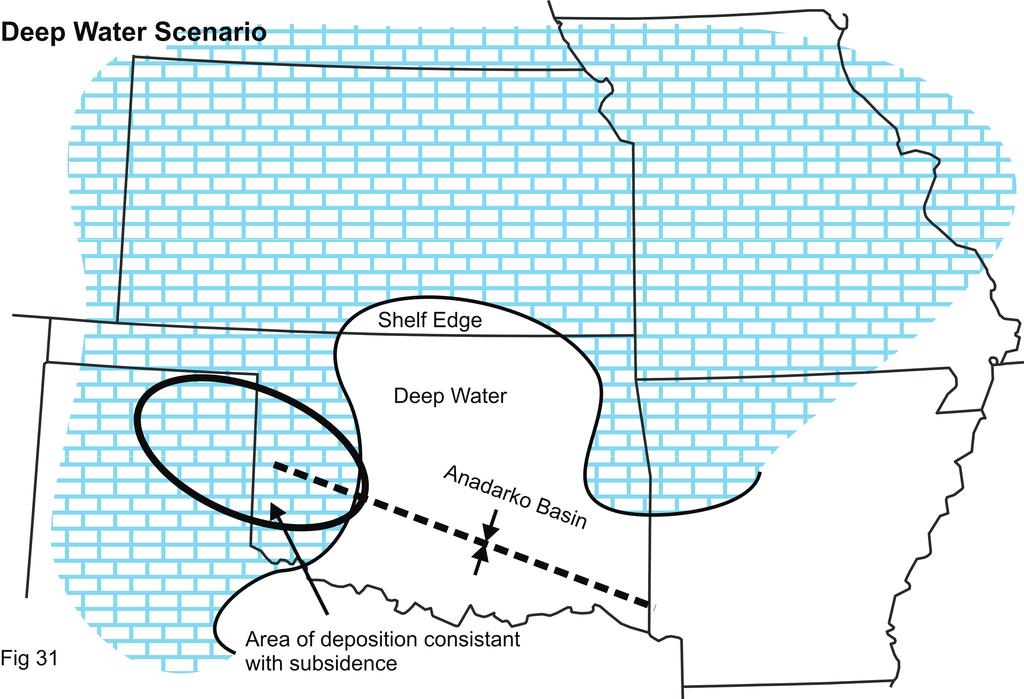
31
32
33 Goebel, 1968 Watney, Guy and Byrnes, 2001 Thompson, 1986 PENN CHESTERIAN DES MOINESIAN CHEROKEE CHESTER INOLA LIME BARTLESVILLE MISSISSIPPIAN/PENNSYLVANIAN? CHAT (EROSIONAL RESIDIUM AT UNCONFORMITY) Fig 34 Correlation for Reeds Spring MISSISSIPPIAN KINDERHOOKIAN OSAGEAN MERAMECIAN ONLAPPING MERAMEC UNDIFFERENTIATED PROGRADING MERAMEC UNDIFFERENTIATED COWLEY facies NORTHVIEW FM. COMPTON LIMESTONE KINDERHOOK SHALE WOODFORD SHALE Goebel, 1968 Reprinted by Permission of, AAPG. Watney, Guy and Byrnes, 2001 Reprinted by Permission of, AAPG. Thompson, 1986 Reprinted by permission of, Division of Geology and Land Survey, Report of Investigations 70.
34 Description of Reeds Spring Rocks (upper Fern Glen) Missouri - Cherty Limestone, some shaly limestone beds with chert both bedded and discontinuous, some burrows Pinches out north of Springfield Missouri (Boardman, Mazzullo, and Wilhite, Field Conference, GSA meeting 2010, Branson, Missouri Western Kansas - Semi granular and fine textured limestone with silica and sponge spicules common. (Goebel, 1968 ) Fig 36
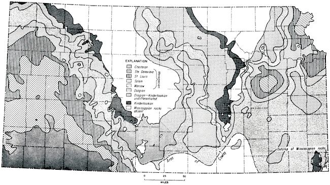
35 Regional Map of the Reeds Spring Reeds Spring probably not deposited Deep Water Fig 37 Extent of Reeds Spring
36
37
38 Goebel, 1968 Watney, Guy and Byrnes, 2001 Thompson, 1986 PENN CHESTERIAN DES MOINESIAN CHEROKEE CHESTER INOLA LIME BARTLESVILLE MISSISSIPPIAN/PENNSYLVANIAN? CHAT (EROSIONAL RESIDIUM AT UNCONFORMITY) Fig 39 Correlation for Burlington/Keokuk MISSISSIPPIAN KINDERHOOKIAN OSAGEAN MERAMECIAN ONLAPPING MERAMEC UNDIFFERENTIATED PROGRADING MERAMEC UNDIFFERENTIATED COWLEY facies NORTHVIEW FM. COMPTON LIMESTONE KINDERHOOK SHALE WOODFORD SHALE Goebel, 1968 Reprinted by Permission of, AAPG. Watney, Guy and Byrnes, 2001 Reprinted by Permission of, AAPG Thompson, 1986 Reprinted by permission of, Division of Geology and Land Survey, Report of Investigations 70.
39
40
41 Goebel, 1968 Watney, Guy and Byrnes, 2001 Thompson, 1986 PENN CHESTERIAN DES MOINESIAN CHEROKEE CHESTER INOLA LIME BARTLESVILLE MISSISSIPPIAN/PENNSYLVANIAN? CHAT (EROSIONAL RESIDIUM AT UNCONFORMITY) Fig 44 Correlation of Cowley MISSISSIPPIAN KINDERHOOKIAN OSAGEAN MERAMECIAN ONLAPPING MERAMEC UNDIFFERENTIATED PROGRADING MERAMEC UNDIFFERENTIATED COWLEY facies NORTHVIEW FM. COMPTON LIMESTONE KINDERHOOK SHALE WOODFORD SHALE Goebel, 1968 Reprinted by Permission of, AAPG. Watney, Guy and Byrnes, 2001 Reprinted by Permission of, AAPG Thompson, 1986 Reprinted by permission of, Division of Geology and Land Survey, Report of Investigations 70.
42
43
44
45
46
47
48
49

50
51
52
53
54
55


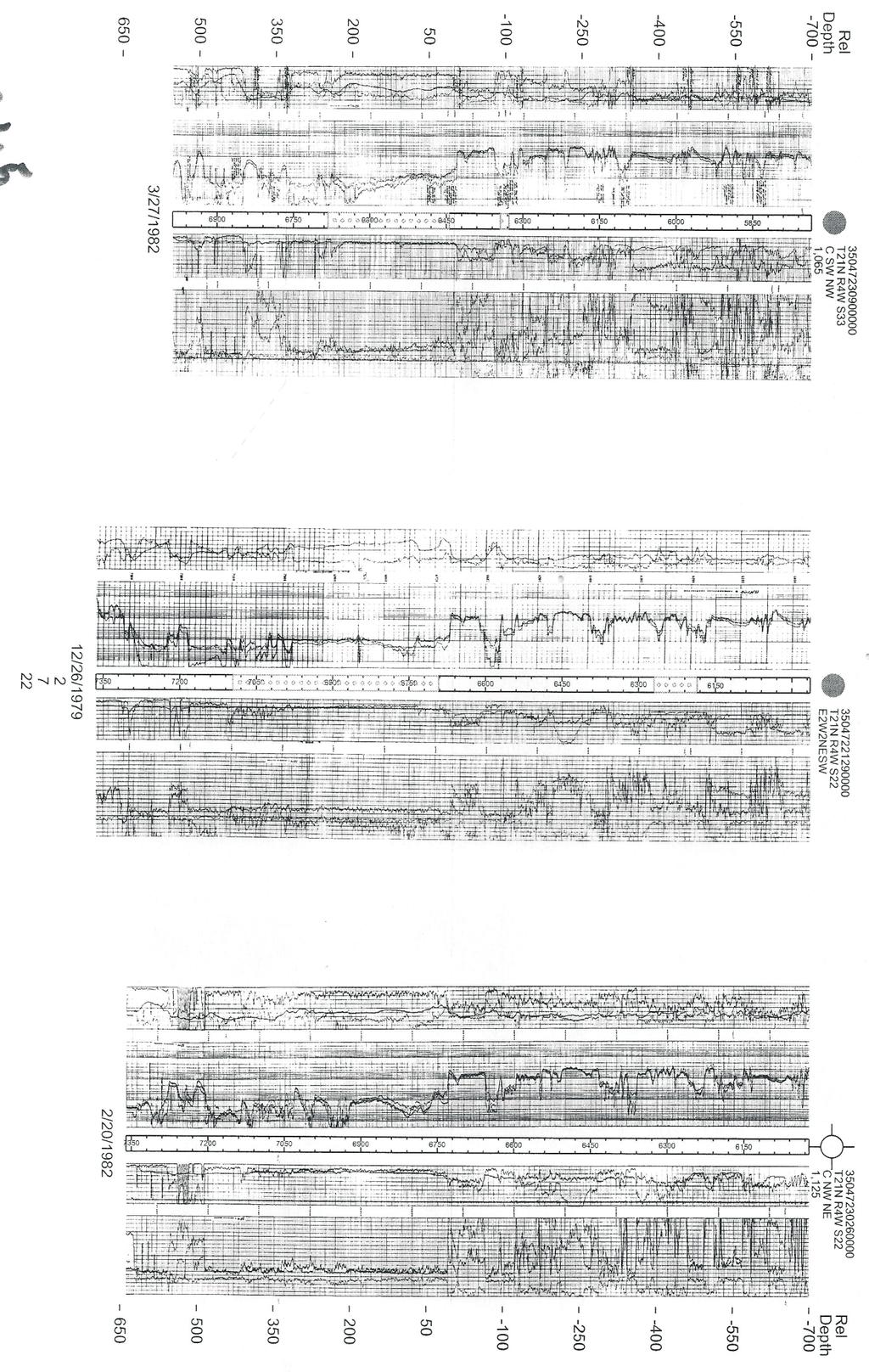
56 T21N R6W S1 C SW NW 1, MSSP 6100 Top of Onlapping Meremac Top Prograding Meramec Top Woodford ,046 66,655 8/23/1977 Fig 61 Type log to distinguish prograding from onlapping Meramecian beds


57
58
59
60
61
62
63
64
65
66
67
68 Deposition of Osagean Section Kansas Oklahoma SEA LEVEL Deposition of Cowley Compton/Northview Kansas Oklahoma OSAGEAN Osagean/Meramecian Unconformity SKY SEA LEVEL SEA LEVEL Kansas Oklahoma SEA LEVEL OSAGEAN Deposition of Prograding Meramecian Aged Sediments Fig 74 Illustration of Kinderhookian to Maramecian Deposition
69
70 Kansas Oklahoma Lime, Thin Shales, & Cherts Post-Mississippian/Pre-Pennsylvanian Unconformity Osagean Sediments CHESTERIAN STRATA ONLAPPING MERAMECIAN STRATA Prograding Meramecian Sediments Kansas Oklahoma Meramecian Tripolitic Chert Unaltered Meramecian Strata Sea Level Lime, Thin Shales, & Cherts CHESTERIAN STRATA ONLAPPING MERAMECIAN STRATA PRE-MISSISSIPPIAN SURFACE Kansas Oklahoma PENNSYLVANIAN AGE SEAS Lime Cap CHESTERIAN MERAMECIAN LIMESTONES & SHALES Fig 76 Illustration of chat strand line- between Meramecian Tripolitic Chert and Unaltered Meramecian Strata
71
72
73
TYPES OF OSAGEAN/MERAMECIAN RESERVOIR SYSTEMS
 Field Examples of Osagean/Meramecian Reservoir Systems Goals by Kurt Rottmann Highlight the characteristics of the major reservoir systems Suggest how the Mississippian horizontal play can be expanded
Mississippian Stratigraphic Nomenclature Revisions in Kansas
 Mississippian Stratigraphic Nomenclature Revisions in Kansas Evan K. Franseen 1,3, Robert S. Sawin 1,3, W. Lynn Watney 1,3, Ronald R. West 2,3, Anthony Layzell 1,3, and Greg A. Ludvigson 1,3 1 Kansas Geological
Upper Viséan (Meramecian-Chesterian) Conodont Biostratigraphy of the SW Ozarks of NW Oklahoma, SW Missouri, and NW Arkansas
 Conodont Biostratigraphy of the SW Ozarks of NW Oklahoma, SW Missouri, and NW Arkansas") Upper Viséan (Meramecian-Chesterian) Conodont Biostratigraphy of the SW Ozarks of NW Oklahoma, SW Missouri, and NW Arkansas Cory J. Godwin 1 and James O. Puckette 2 1 Consulting Geologist, Tulsa, Oklahoma,
Upper Viséan (Meramecian-Chesterian) Conodont Biostratigraphy of the SW Ozarks of NW Oklahoma, SW Missouri, and NW Arkansas Cory J. Godwin 1 and James O. Puckette 2 1 Consulting Geologist, Tulsa, Oklahoma,
Lower Mississippian Sequence Stratigraphy and Depositional Dynamics: Insights from the Outcrops, Northwestern Arkansas and Southwestern Missouri
 Lower Mississippian Sequence Stratigraphy and Depositional Dynamics: Insights from the Outcrops, Northwestern Arkansas and Southwestern Missouri Walter L. Manger Professor of Geology, Emeritus University
University of Arkansas, Fayetteville. Thomas Cahill University of Arkansas, Fayetteville. Theses and Dissertations
 University of Arkansas, Fayetteville ScholarWorks@UARK Theses and Dissertations 5-2014 Subsurface Sequence Stratigraphy and Reservoir Characterization of the Mississippian Limestone (Kinderhookian to Meramecian),
Understanding Mississippi Dolomite Reservoirs in Central Kansas
 Understanding Mississippi Dolomite Reservoirs in Central Kansas Martin K. Dubois, Alan P. Byrnes, and Saibal Bhattacharya. We wish to acknowledge support by U.S. Department of Energy and Mull Drilling
Fluid Migration and Accumulation within the Mississippian: Why 2% oil cut here, 15% oil cut one mile away
 Fluid Migration and Accumulation within the Mississippian: Why 2% oil cut here, 15% oil cut one mile away W. Lynn Watney Kansas Geological Survey Lawrence, KS 66006 KSCO2 Outline Mississippi Lime Play
PETROLOGIC AND PETROPHYSICAL CHARACTERISTICS: MISSISSIPPIAN CHERT, OKLAHOMA MIN ZHAO. Bachelor of Science in Geology
 PETROLOGIC AND PETROPHYSICAL CHARACTERISTICS: MISSISSIPPIAN CHERT, OKLAHOMA By MIN ZHAO Bachelor of Science in Geology China University of Petroleum (Beijing) Beijing, China 2009 Submitted to the Faculty
Downloaded 03/27/18 to Redistribution subject to SEG license or copyright; see Terms of Use at
 Calibrating seismic fracture prediction using borehole image logs, application to the Mississippian Limestone Stephanie Cook*, Abdulmohsen Alali, Kurt J. Marfurt, Matthew J. Pranter The University of Oklahoma
Mechanical Stratigraphy of the Mississippian in Osage County, Oklahoma
 University of Arkansas, Fayetteville ScholarWorks@UARK Theses and Dissertations 5-2014 Mechanical Stratigraphy of the Mississippian in Osage County, Oklahoma Caleb James Jennings University of Arkansas,
Stratigraphic architecture of the Mississippian limestone through integrated electrofacies classification, Hardtner field area, Kansas and Oklahoma
 t Technical papers Stratigraphic architecture of the Mississippian limestone through integrated electrofacies classification, Hardtner field area, Kansas and Oklahoma Niles W. Wethington 1 and Matthew
Downloaded 01/29/13 to Redistribution subject to SEG license or copyright; see Terms of Use at
 An integrated study of a Mississippian tripolitic chert reservoir Osage County, Oklahoma, USA Benjamin L. Dowdell*, Atish Roy, and Kurt J. Marfurt, The University of Oklahoma Summary With the advent of
Analysis of Tripolitic Chert in the Boone Formation (Lower Mississippian, Osagean), Northwest Arkansas and Southwestern Missouri
, Northwest Arkansas and Southwestern Missouri") University of Arkansas, Fayetteville ScholarWorks@UARK Theses and Dissertations 8-2013 Analysis of Tripolitic Chert in the Boone Formation (Lower Mississippian, Osagean), Northwest Arkansas and Southwestern
University of Arkansas, Fayetteville ScholarWorks@UARK Theses and Dissertations 8-2013 Analysis of Tripolitic Chert in the Boone Formation (Lower Mississippian, Osagean), Northwest Arkansas and Southwestern
Kansas Geological Survey
 Kansas Geological Survey Public Information Circular 33 The Mississippian Limestone Play in Kansas: Oil and Gas in a Complex Geologic Setting Catherine S. Evans and K. David Newell, Kansas Geological Survey
UNIVERSITY OF OKLAHOMA GRADUATE COLLEGE
 UNIVERSITY OF OKLAHOMA GRADUATE COLLEGE FRACTURE CHARACTERIZATION OF THE MISSISSIPPI LIME UTILIZING WHOLE CORE, HORIZONTAL BOREHOLE IMAGES, AND 3D SEISMIC DATA FROM A MATURE FIELD IN NOBLE COUNTY OKLAHOMA
QUANTIFYING AND ANALYZING RELATIONSHIPS BETWEEN WELL LOG ATTRIBUTES AND PRODUCTION FOR THE MISSISSIPPIAN PLAY IN WOODS COUNTY, OK CLINT BAREFOOT
 QUANTIFYING AND ANALYZING RELATIONSHIPS BETWEEN WELL LOG ATTRIBUTES AND PRODUCTION FOR THE MISSISSIPPIAN PLAY IN WOODS COUNTY, OK By CLINT BAREFOOT Bachelor of Science in Business Administration Oklahoma
The Problem of the Welden, Sycamore and Lower Caney in the Eastern Arbuckle Mountains
 120 PROC. OF THE OKLA. ACAD. OF SCI. FOR 1958 The Problem of the Welden, Sycamore and Lower Caney in the Eastern Arbuckle Mountains STEVE C. CHAMPLIN, University of Oklahoma, Norman This paper is a preliminary
Correlation of seismic attributes and geo-mechanical properties to the rate of penetration in the
 1 2 Correlation of seismic attributes and geo-mechanical properties to the rate of penetration in the Mississippian Limestone, Oklahoma 3 Xuan Qi, Joseph Snyder, Tao Zhao, Kurt J. Marfurt, and Matthew
MISSISSIPPIAN DEPOSITIONAL HISTORY OF THE TEXAS PANHANDLE: A REAPPRAISAL. Stephen C. Ruppel. Topical Report
 OF-WTWI-1985-15 Revision 1 MISSISSIPPIAN DEPOSITIONAL HISTORY OF THE TEXAS PANHANDLE: A REAPPRAISAL Stephen C. Ruppel Topical Report Prepared for the U. S. Department of Energy Salt Repository Project
Analysis of the Upper Devonian to Lower Carboniferous (Frasnian-Tournaisian) Woodford Shale in the KGS-OGS Current #1, Southwestern Arkoma Basin*
 Woodford Shale in the KGS-OGS Current #1, Southwestern Arkoma Basin*") Analysis of the Upper Devonian to Lower Carboniferous (Frasnian-Tournaisian) Woodford Shale in the KGS-OGS Current #1, Southwestern Arkoma Basin* W. Lynn Watney 1, Darwin R. Boardman 2, Jim O. Puckette
Analysis of the Upper Devonian to Lower Carboniferous (Frasnian-Tournaisian) Woodford Shale in the KGS-OGS Current #1, Southwestern Arkoma Basin* W. Lynn Watney 1, Darwin R. Boardman 2, Jim O. Puckette
Chapter 4: Sequence Stratigraphy of the Cherokee Group
 Chapter 4: Sequence Stratigraphy of the Cherokee Group 4.1 Sequence Stratigraphic Nomenclature Sequence stratigraphic concepts provide a framework to better explain and predict the lateral distribution,
CHAPTER 3: COAL-BEARING INTERVALS OF THE BOURBON ARCH
 68 CHAPTER 3: COAL-BEARING INTERVALS OF THE BOURBON ARCH 69 3.1 Introduction The examination of Desmoinesian coal-bearing intervals includes: 1) facies successions and their associated well-log characteristics;
GEOLOGY MEDIA SUITE Chapter 8
 UNDERSTANDING EARTH, SIXTH EDITION GROTZINGER JORDAN GEOLOGY MEDIA SUITE Chapter 8 Clocks in Rocks Timing the Geologic Record 2010 W.H. Freeman and Company Stratigraphy and fossils Figure 8.4 (page 172)
High-resolution Sequence Stratigraphy of the Glauconitic Sandstone, Upper Mannville C Pool, Cessford Field: a Record of Evolving Accommodation
 Page No. 069-1 High-resolution Sequence Stratigraphy of the Glauconitic Sandstone, Upper Mannville C Pool, Cessford Field: a Record of Evolving Accommodation Thérèse Lynch* and John Hopkins, Department
Later Mississippian. Sun, seas, and reefs
 Later Mississippian Sun, seas, and reefs P. David Polly Department of Geological Sciences Indiana University Bloomington, Indiana 47405 USA pdpolly@indiana.edu Bahama Banks Space shuttle photo by Chris
Sedimentary rocks. Mechanical Weathering. Weathering. Chemical weathering. Rates of weathering. Fossil Fuel Resources. Two kinds of weathering
 Sedimentary rocks Fossil Fuel Resources Exam next Tuesday February 14 Bring Scantron and Review Questions About 75% of all rock outcrops on the continents Important to reconstruct much of Earth's history
Paradoxes to Mississippian Production
 Goals Field Examples of Fracturing and Drainage by Kurt Rottmann Understand fracture patterns in the Mississippian Review older fracture identification logs Review fracture components to volumetric OOIP
Student Research & Creative Works
 Scholars' Mine Masters Theses Student Research & Creative Works 1966 Structure contours on the top and base of the M bed, the relationship of mineralization to structures, and the variation of the M bed
Depositional History of the St. Joe and Boone Formations in Northern Arkansas
 Journal of the Arkansas Academy of Science Volume 40 Article 22 1986 Depositional History of the St. Joe and Boone Formations in Northern Arkansas Phillip R. Shelby University of Arkansas, Fayetteville
Geology and Energy Resources of the Arkoma Basin, Oklahoma and Arkansas
 UMR Journal -- V. H. McNutt Colloquium Series Volume 3 Article 6 12-1-1982 Geology and Energy Resources of the Arkoma Basin, Oklahoma and Arkansas Boyd R. Haley Follow this and additional works at: http://scholarsmine.mst.edu/umr-journal
Mississippian Strata in Southeastern New Mexico, Including the Barnett Shale: Thickness, Structure and Hydrocarbon Plays
 Mississippian Strata in Southeastern New Mexico, Including the Barnett Shale: Thickness, Structure and Hydrocarbon Plays by Ronald F. Broadhead New Mexico Bureau of Geology and Mineral Resources A Division
Vail et al., 1977b. AAPG 1977 reprinted with permission of the AAPG whose permission is required for further use.
 Well 5 Well 4 Well 3 Well 2 Well 1 Vail et al., 1977b AAPG 1977 reprinted with permission of the AAPG whose permission is required for further use. Well 5 Well 4 Well 3 Well 2 Well 1 Vail et al., 1977b
Groundwater Resources of Missouri. Cynthia Brookshire, R. G.
 Groundwater Resources of Missouri Cynthia Brookshire, R. G. GROUNDWATER... Water beneath the Earth s surface within a zone of saturation AQUIFER... A geologic formation or group of formations that are
Seismic Stratigraphy of the Fang Basin, Chiang Mai, Thailand Rungsun Nuntajun
 Chiang Mai J. Sci. 2009; 36(1) 77 Chiang Mai J. Sci. 2009; 36(1) : 77-82 www.science.cmu.ac.th/journal-science/josci.html Contributed Paper Seismic Stratigraphy of the Fang Basin, Chiang Mai, Thailand
Changes to the Late Paleozoic Strata of the Mid-Continent of the U.S. Cherokee to the Kansas City Groups
 Changes to the Late Paleozoic Strata of the Mid-Continent of the U.S Cherokee to the Kansas City Groups By Ken Stalder March 12, 2011 Terms for Confusion Stratigraphy - the study of layered sequences of
Kansas Interdisciplinary Carbonates Consortium Proposal June 2012
 I. Integrated Sequence Stratigraphy and Bio- and Chemo- Stratigraphy of the Late Devonian-Mississippian strata II. Structural Kinematics and Mechanical Stratigraphy of the Pre- Pennsylvanian: Carbonate
Overview of Selected Shale Plays in New Mexico*
 Overview of Selected Shale Plays in New Mexico* Ron Broadhead 1 Search and Discovery Article #10627 (2014)** Posted August 18, 2014 *Adapted from presentation at RMAG luncheon meeting, Denver, Colorado,
Pre-stack Seismic Attribute Analysis of the Mississippian Chert and the Arbuckle Group at the Wellington Field, South-central Kansas
 Pre-stack Seismic Attribute Analysis of the Mississippian Chert and the Arbuckle Group at the Wellington Field, South-central Kansas By Yousuf Fadolalkarem Submitted to the graduate degree program in Geology
Chapter 15. The Late Paleozoic World
 Chapter 15 The Late Paleozoic World Guiding Questions How did marine life of late Paleozoic time differ from that of middle Paleozoic time? How did terrestrial floras change on a global scale in late Paleozoic
IP 121 ILLINOIS PETROLEUJM Illinois Institute of Natdral Resources STATE GEOWGICA SURVEY DIVISION' Jack A. Simon. Chief
 IP 121 ILLINOIS PETROLEUJM 121 1981 Illinois Institute of Natdral Resources STATE GEOWGICA SURVEY DIVISION' Jack A. Simon. Chief Stevenson, D. L. (David L.) Geologic structure of the base of the New Albany
Horizontal Drilling Technology Review, Current Applications, and It s Future in Developing Kansas Petroleum Resources
 Horizontal Drilling Technology Review, Current Applications, and It s Future in Developing Kansas Petroleum Resources W. Lynn Watney Kansas Geological Survey Lawrence, KS 66047 lwatney@kgs.ku.edu Outline
Unconventional Oil Plays Opportunity vs Risk
 Unconventional Oil Plays Opportunity vs Risk EnerCom s London Oil & Gas Conference 4 June 14, 2012 Sofitel London Danny D. Simmons 1000 BOPD - What a great well! 10,000 1,000 BOPD 100 10 12/2009 1/2010
KRIS wsbssm. IBHiiilll
 KRIS wsbssm IBHiiilll Digitized by the Internet Archive in 2012 with funding from University of Illinois Urbana-Champaign http://archive.org/details/engineeringaspec34ekbl STATE OF ILLINOIS HENRY HORNER,
The Booch Sandstones (McAlester Formation, Krebs Group), Arkoma Basin, Oklahoma Outcrops to Well Logs: An Introduction to Oklahoma Fluvial Reservoirs*
, Arkoma Basin, Oklahoma Outcrops to Well Logs: An Introduction to Oklahoma Fluvial Reservoirs*") The Booch Sandstones (McAlester Formation, Krebs Group), Arkoma Basin, Oklahoma Outcrops to Well Logs: An Introduction to Oklahoma Fluvial Reservoirs* Neil H. Suneson 1 Search and Discovery Article #10210
The Booch Sandstones (McAlester Formation, Krebs Group), Arkoma Basin, Oklahoma Outcrops to Well Logs: An Introduction to Oklahoma Fluvial Reservoirs* Neil H. Suneson 1 Search and Discovery Article #10210
Sedimentary and Stratigraphic Analysis of the Viking Sand in the Edgerton/Wainwright Area, Central Alberta* By Russell Walz 1
 Sedimentary and Stratigraphic Analysis of the Viking Sand in the Edgerton/Wainwright Area, Central Alberta* By Russell Walz 1 Search and Discovery Article #50030 (2006) Posted June 25, 2006 *Extended abstract
Geol 755: Basin Analysis Geophysics Week 4.5. Seismic Stratigraphy Basics. Seismic Sequence Analysis. Seismic Sequence Analysis
 Geol 755: Basin Analysis Geophysics Week 4.5 John N. Louie, Presenter Seismic Stratigraphy Basics Reflector Terminations Sequence Boundary Identification Procedure Example Objective: Define the genetic
Fossils and Geology of Litzsinger Road Ecology Center
 Fossils and Geology of Litzsinger Road Ecology Center Table of Content Key Terms 1 Key Terms 2 What you need to know Geologic Map of Missouri Geologic Time Chart More of what you need to know Digital map
Sedimentology & Stratigraphy. Thanks to Rob Viens for slides
 Sedimentology & Stratigraphy Thanks to Rob Viens for slides Sedimentology The study of the processes that erode, transport and deposit sediments Sedimentary Petrology The study of the characteristics and
Evan K. Franseen, Dustin Stolz, Robert H. Goldstein, KICC, Department of Geology, University of Kansas
 Reservoir Character of the Avalon Shale (Bone Spring Formation) of the Delaware Basin, West Texas and Southeast New Mexico: Effect of Carbonate-rich Sediment Gravity Flows Evan K. Franseen, Dustin Stolz,
Devonian-Mississippian Petroleum Systems of Southern Laurasia: What Makes the STACK-Merge-SCOOP Play in Oklahoma so Special*
 Devonian-Mississippian Petroleum Systems of Southern Laurasia: What Makes the STACK-Merge-SCOOP Play in Oklahoma so Special* Andrew Cullen 1 Search and Discovery Article #10998 (2017)** Posted October
Stratigraphy. Stratigraphy deals with the study of any layered (stratified) rock, but primarily with sedimentary rocks and their
 rock, but primarily with sedimentary rocks and their") Stratigraphy Stratigraphy deals with the study of any layered (stratified) rock, but primarily with sedimentary rocks and their composition origin age relationships geographic extent Stratified Sedimentary
Stratigraphy Stratigraphy deals with the study of any layered (stratified) rock, but primarily with sedimentary rocks and their composition origin age relationships geographic extent Stratified Sedimentary
Outcrops from Every Continent and 20 Countries in 140 Contributions. Tor H. Nilsen, Roger D. Shew, Gary S. Steffens, and Joseph R.J. Studlick.
 Paper VIII Tor H. Nilsen, Roger D. Shew, Gary S. Steffens, and Joseph R.J. Studlick Editors Outcrops from Every Continent and 20 Countries in 140 Contributions http://bookstore.aapg.org Length ~ 23 m (75.5
Seismic stratigraphy, some examples from Indian Ocean, interpretation of reflection data in interactive mode
 Seismic stratigraphy, some examples from Indian Ocean, interpretation of reflection data in interactive mode K. S. Krishna National Institute of Oceanography, Dona Paula, Goa-403 004. krishna@nio.org Seismic
Geology Stratigraphic Correlations (Lab #4, Winter 2010)
") Name: Answers Reg. lab day: Tu W Th Geology 1023 Stratigraphic Correlations (Lab #4, Winter 2010) Introduction Stratigraphic correlation is the process of comparing rocks at one locality with related rocks
Name: Answers Reg. lab day: Tu W Th Geology 1023 Stratigraphic Correlations (Lab #4, Winter 2010) Introduction Stratigraphic correlation is the process of comparing rocks at one locality with related rocks
Introduction to Geology Spring 2008
 MIT OpenCourseWare http://ocw.mit.edu 12.001 Introduction to Geology Spring 2008 For information about citing these materials or our Terms of Use, visit: http://ocw.mit.edu/terms. Regional metamorphism
Application of Cutting-Edge 3-D Seismic Attribute Technology to the Assessment of Geological Reservoirs for CO2 Sequestration
 Application of Cutting-Edge 3-D Seismic Attribute Technology to the Assessment of Geological Reservoirs for CO2 Sequestration Type of Report: Frequency of Report: Progress Quarterly Reporting Period: April
Department of Geology and Geography, West Virginia University, Morgantown, West Virginia, U.S.A.
 16 Nissen, S. E., T. R. Carr, K. J. Marfurt, and E. C. Sullivan, 2009, Using 3-D seismic volumetric curvature attributes to identify fracture trends in a depletedmississippian carbonate reservoir: Implications
1 Hfli. ^^Hi. 11 mw\i. mmsisi i lull I. IMMRrtHttiifHmiititlK. RibWh. llml ''.' 1 ffililsiillsll8 ill. iiiinitsim IK«
 l i. :,, v. i :! 1.» r =,
Part Regional structural/tectonic framework during the late Paleozoic and significance to reservoir systems.
 Part 2. -- Regional structural/tectonic framework during the late Paleozoic and significance to reservoir systems. Regional structural/tectonic framework Bill Thomas 2005 GSA presidential address Tectonic
Unconformities are depositional contacts that overlie rocks distinctly older than they are. They are often called gaps in the sedimentary record.
 UNCONFORMITIES Unconformities are depositional contacts that overlie rocks distinctly older than they are. They are often called gaps in the sedimentary record. The contact represents time when no sediment
Paleoslope and water depth estimate, lower Wolfcampian, Hugoton embayment of
 Paleoslope and water depth estimate, lower Wolfcampian, Hugoton embayment of the Anadarko basin Martin K. Dubois, Kansas Geological Survey Abstract Three criteria are used in combination to estimate paleoslope
Geometric attributes such as coherence and curvature are
 SATINDER CHOPRA, Arcis Seismic Solutions, Calgary, Canada KURT J. MARFURT, University of Oklahoma, Norman, USA Geometric attributes such as coherence and curvature are commonly used for mapping structural
The Geology of the Arbuckle Group in the Midcontinent: Sequence Stratigraphy, Reservoir Development, and the Potential for Hydrocarbon Exploration*
 The Geology of the Arbuckle Group in the Midcontinent: Sequence Stratigraphy, Reservoir Development, and the Potential for Hydrocarbon Exploration* Richard D. Fritz 1, Patrick Medlock 2, Michael J. Kuykendall
FY 2013 Annual Technical Report for NCRDS State Cooperative Program
 FY 2013 Annual Technical Report for NCRDS State Cooperative Program SUBSURFACE GAS-SHALE SAMPLES OF THE UPPER DEVONIAN AND LOWER MISSISSIPPIAN WOODFORD SHALE, PERMIAN BASIN, WEST TEXAS AND SOUTHEASTERN
Tim Carr - West Virginia University
 Tim Carr - West Virginia University Understanding Seismic Data Resolution (Vertical and Horizontal) Common Depth Points (CDPs) Two way time (TWT) Time versus depth Interpretation of Reflectors 2 Able to
Distribution, petrology, and environment of the St. Louis-Ste. Genevieve transition zone in Missouri
 Scholars' Mine Masters Theses Student Theses and Dissertations 1971 Distribution, petrology, and environment of the St. Louis-Ste. Genevieve transition zone in Missouri Donald Howerton Fielding Follow
Art Saller 1. Search and Discovery Article #10606 (2014) Posted June 30, 2014
 Posted June 30, 2014") Late Pennsylvanian and Early Permian Sedimentation on the Central Basin Platform and Implications to the Wolfberry Deposition in the Western Midland Basin* Art Saller 1 Search and Discovery Article #10606
Late Pennsylvanian and Early Permian Sedimentation on the Central Basin Platform and Implications to the Wolfberry Deposition in the Western Midland Basin* Art Saller 1 Search and Discovery Article #10606
The Nature of Sedimentary Rocks
 The Nature of Sedimentary Rocks Sedimentary rocks are composed of: Fragments of other rocks Chemical precipitates Organic matter or biochemically produced materials The Nature of Sedimentary Rocks Sedimentary
Geological Framework for Active Resource Plays in Oklahoma. Edith Newton Wilson, PhD Rock Whisperer LLC March 4, 2014
 Geological Framework for Active Resource Plays in Oklahoma Edith Newton Wilson, PhD Rock Whisperer LLC March 4, 2014 Oklahoma Oil Production 2000: 200,000 bopd* 2013: 300,000 bopd** 10 6 What Oklahoma
Case Study of the Structural and Depositional-Evolution Interpretation from Seismic Data*
 Case Study of the Structural and Depositional-Evolution Interpretation from Seismic Data* Yun Ling 1, Xiangyu Guo 1, Jixiang Lin 1, and Desheng Sun 1 Search and Discovery Article #20143 (2012) Posted April
Dakota Sandstone. of the Moxa Arch and Surrounding Green River Basin
 Dakota Sandstone of the Moxa Arch and Surrounding Green River Basin Dakota Sandstones of the Green River Basin Overview The Dakota sandstones of the Moxa Arch and surrounding Green River Basin remain attractive
Application of Cutting-Edge 3D Seismic Attribute Technology to the Assessment of Geological Reservoirs for CO2 Sequestration
 Application of Cutting-Edge 3D Seismic Attribute Technology to the Assessment of Geological Reservoirs for CO2 Sequestration Type of Report: Frequency of Report: Progress Quarterly Reporting Period: January
Sediment. Weathering: mechanical and chemical decomposition and disintegration of rock and minerals at the surface
 Sediment Some basic terminology Weathering: mechanical and chemical decomposition and disintegration of rock and minerals at the surface Erosion: removal of weathered rock and minerals from one place to
GEOLOGICAL LOG INTERPRETATION TUTORIAL
 GEOLOGICAL LOG INTERPRETATION TUTORIAL Text and Figures by Geoff Bohling and John Doveton The following pages will familiarize you with the basics of the geological interpretation of common logs as they
Request For Bids Parcels
 Section 2 Page 14 This section provides a detailed description of each landsale parcel. Maps provided show the location of the land parcels and the released seismic data on those parcels. Hard copies and
New Mexico Geological Society
 New Mexico Geological Society Downloaded from: http://nmgs.nmt.edu/publications/guidebooks/28 Pre-carboniferous paleotectonics of the San Juan Basin, New Mexico G. M. Stevenson and D. L. Baars, 1977, pp.
Lower Skinner Valley Fill Sandstones: Attractive Exploration Targets on the Northeast Oklahoma Platform*
 Lower Skinner Valley Fill Sandstones: Attractive Exploration Targets on the Northeast Oklahoma Platform* By Jim Puckette 1 Search and Discovery Article #10050 (2003) *Adapted from presentation to Tulsa
Dissolution-enlarged fractures imaging using electrical resistivity tomography (ERT)
") Scholars' Mine Doctoral Dissertations Student Theses and Dissertations Spring 2017 Dissolution-enlarged fractures imaging using electrical resistivity tomography (ERT) Elnaz Siami-Irdemoosa Follow this
Scholars' Mine Doctoral Dissertations Student Theses and Dissertations Spring 2017 Dissolution-enlarged fractures imaging using electrical resistivity tomography (ERT) Elnaz Siami-Irdemoosa Follow this
Geological History of the Grand Canyon
 Geological History of the Grand Canyon For a copy of this assignment, print a copy of this web page. The Project Your job is to write a short paper that describes the geological history of the Grand Canyon
Seismic Attributes and Their Applications in Seismic Geomorphology
 Academic article Seismic Attributes and Their Applications in Seismic Geomorphology Sanhasuk Koson, Piyaphong Chenrai* and Montri Choowong Department of Geology, Faculty of Science, Chulalongkorn University,
Seismic modeling evaluation of fault illumination in the Woodford Shale Sumit Verma*, Onur Mutlu, Kurt J. Marfurt, The University of Oklahoma
 Seismic modeling evaluation of fault illumination in the Woodford Shale Sumit Verma*, Onur Mutlu, Kurt J. Marfurt, The University of Oklahoma Summary The Woodford Shale is one of the more important resource
Cretaceous, Dakota Formation, Terra Cotta Member South Side of I-70, Salina County, Kansas
 Cretaceous, Dakota Formation, Terra Cotta Member South Side of I-70, Salina County, Kansas Written By: Steven D.J. Baumann G-102010-1A Outcrop looking southeast Photo taken by: Steven Baumann on 10-20-2010
Chapter 2: Coal Deposits of the Cherokee Basin
 Chapter 2: Coal Deposits of the Cherokee Basin Previous work by Harris (1984) and Stanton (1987) divided the Cherokee Group into ten stratigraphic intervals using laterally persistent dark-gray to black
Block 43B - Onshore Oman
 Block 43B - Onshore Oman SUMMARY Block 43B is an 11,967 km 2 area located along the coastal area of Oman north of the Hajar Mountains. This is an unexplored region, both geographically and stratigraphically.
Reservoir Modelling of a Bioclastic Calcarenite Complex on Favignana, Southern Italy: The Application of Multi-point Statistics*
 Reservoir Modelling of a Bioclastic Calcarenite Complex on Favignana, Southern Italy: The Application of Multi-point Statistics* Robert Kil 1 and Andrea Moscariello 2,3 Search and Discovery Article #50548
Sedimentary Environments Chapter 8
 Sedimentary Environments Chapter 8 Does not contain complete lecture notes. To be used to help organize lecture notes and home/test studies. What is a sedimentary rock? Sedimentary rocks are products of
Geologic Map of the Hatch Quadrangle, Doña County, New Mexico
 Geologic Map of the Hatch Quadrangle, Doña County, New Mexico By William R. Seager May 1995 New Mexico Bureau of Geology and Mineral Resources Open-file Digital Geologic Map OF-GM 213 Scale 1:24,000 This
Accommodation. Tectonics (local to regional) Subsidence Uplift
 Subsidence Uplift") Accommodation Accommodation varies over time; it is the distance between a reference horizon and the sea surface (i.e. relative sea level). The space to be filled in with sediments or water What are the
Accommodation Accommodation varies over time; it is the distance between a reference horizon and the sea surface (i.e. relative sea level). The space to be filled in with sediments or water What are the
Depositional Sequences Sequences
 Depositional Sequences Transgressive and Regressive packages can be bound by unconformities Because sediment can only be preserved during net aggradation and progradation All other times there is either
A Geochemical Analysis of the Arkansas Novaculite and Comparison to the Siliceous Deposits of the Boone Formation
 University of Arkansas, Fayetteville ScholarWorks@UARK Theses and Dissertations 5-2016 A Geochemical Analysis of the Arkansas Novaculite and Comparison to the Siliceous Deposits of the Boone Formation
Nathan D. Webb and James L. Best
 Nathan D. Webb and James L. Best Background Pennsylvanian oil production Stratigraphy & geologic setting Study area Methods Using geophysical logs & core Results Comparing three channel deposits Implications
Depositional Environments. Depositional Environments
 Depositional Environments Geographic area in which sediment is deposited Characterized by a combination of geological process & environmental conditions Depositional Environments Geological processes:
PLEASE DO NOT WRITE ON THIS QUIZ! Relative Dating and Stratigraphic Principles Quiz
 PLEASE DO NOT WRITE ON THIS QUIZ! Relative Dating and Stratigraphic Principles Quiz TEST NO A Multiple Choice Identify the letter of the choice that best completes the statement or answers the question.
A.M. TUESDAY, 12 May hours
 Candidate Name Centre Number 2 Candidate Number GCE AS/A level 1212/01 New AS GEOLOGY - GL2a Investigative Geology A.M. TUESDAY, 12 May 2009 1 1 2 hours For Examiner s Use Only ADDITIONAL MATERIALS In
SCOOP HORIZONTAL WOODFORD PROJECT
 SCOOP HORIZONTAL WOODFORD PROJECT Far West Development (FWD) Proposes a non operated Horizontal Woodford Shale well (10,000 lateral) in the South Central Oklahoma Oil Province SCOOP. Newfield Exploration
Mammoth Cave National Park, Kentucky
 Mammoth Cave National Park, Kentucky Objectives of Today s Lecture Refresher on Sedimentary Depositional Systems and Rock Classifications Transgressive and Regressive Marine Environments Carbonate Depositional
Follow this and additional works at: Part of the Geology Commons
 Western Michigan University ScholarWorks at WMU Michigan Geological Repository for Research and Education Geosciences 2016 Geology of Michigan William B. Harrison III Michigan Geological Repository for
STATE BUREAU OF MINES AND MINERAL RESOURCES NEW MEXICO INSTITUTE OF MINING AND TECHNOLOGY
 CIRCULAR 63 GEOLOGIC NOTES ON THE DELAWARE BASIN by Leon Haigler United States Geological Survey Published in cooperation with the United States Geological Survey 1962 STATE BUREAU OF MINES AND MINERAL
Sediments and Sedimentary Rocks
 Sediments and Sedimentary Rocks (Shaping Earth s Surface, Part 2) Science 330 Summer 2005 What is a sedimentary rock? Products of mechanical and chemical weathering Account for about 5 percent of Earth
THE NEW HARMONY GROUP (LOWER DEVONIAN)
") 2001. Proceedings of the Indiana Academy of Science 1 10:23-27 THE NEW HARMONY GROUP (LOWER DEVONIAN) REVISITED 1 John B. Droste and Alan S. Horowitz Department of Geological Sciences, Indiana : University,
2001. Proceedings of the Indiana Academy of Science 1 10:23-27 THE NEW HARMONY GROUP (LOWER DEVONIAN) REVISITED 1 John B. Droste and Alan S. Horowitz Department of Geological Sciences, Indiana : University,