New Mexico Geological Society
|
|
|
- Sophie Simon
- 5 years ago
- Views:
Transcription
, Fassett, J. F.; James, H. L.; [eds.], New Mexico Geological Society 28 th Annual Fall Field Conference Guidebook, 319 p.")
1 New Mexico Geological Society Downloaded from: Pre-carboniferous paleotectonics of the San Juan Basin, New Mexico G. M. Stevenson and D. L. Baars, 1977, pp in: San Juan Basin III (northwestern New Mexico), Fassett, J. F.; James, H. L.; [eds.], New Mexico Geological Society 28 th Annual Fall Field Conference Guidebook, 319 p. This is one of many related papers that were included in the 1977 NMGS Fall Field Conference Guidebook. Annual NMGS Fall Field Conference Guidebooks Every fall since 1950, the New Mexico Geological Society (NMGS) has held an annual Fall Field Conference that explores some region of New Mexico (or surrounding states). Always well attended, these conferences provide a guidebook to participants. Besides detailed road logs, the guidebooks contain many well written, edited, and peer-reviewed geoscience papers. These books have set the national standard for geologic guidebooks and are an essential geologic reference for anyone working in or around New Mexico. Free Downloads NMGS has decided to make peer-reviewed papers from our Fall Field Conference guidebooks available for free download. Non-members will have access to guidebook papers two years after publication. Members have access to all papers. This is in keeping with our mission of promoting interest, research, and cooperation regarding geology in New Mexico. However, guidebook sales represent a significant proportion of our operating budget. Therefore, only research papers are available for download. Road logs, mini-papers, maps, stratigraphic charts, and other selected content are available only in the printed guidebooks. Copyright Information Publications of the New Mexico Geological Society, printed and electronic, are protected by the copyright laws of the United States. No material from the NMGS website, or printed and electronic publications, may be reprinted or redistributed without NMGS permission. Contact us for permission to reprint portions of any of our publications. One printed copy of any materials from the NMGS website or our print and electronic publications may be made for individual use without our permission. Teachers and students may make unlimited copies for educational use. Any other use of these materials requires explicit permission.
2 This page is intentionally left blank to maintain order of facing pages.
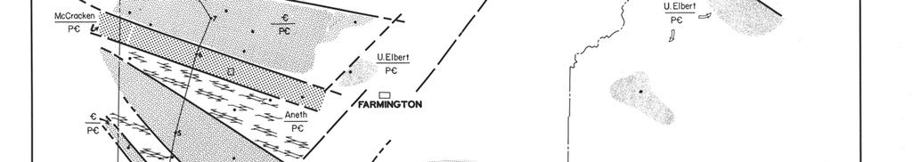
3 New Mexico Geol. Soc. Guidebook, 28th Field Conf., San Juan Basin III, PRE-CARBONIFEROUS PALEOTECTONICS OF THE SAN JUAN BASIN G. M. STEVENSON Consultant Durango, Colorado and D. L. BAARS Department of Geology Fort Lewis College Durango, Colorado INTRODUCTION This paper summarizes and updates the state of knowledge concerning Cambrian-Devonian rock units in the San Juan Basin of northwest New Mexico and southwest Colorado. Earlier workers mapped all outcropping rock units of the Cambrian and Devonian in the Four Corners region. Since this mapping took place 20 to 25 years ago, little information has been published about the early Paleozoic rock units. Deep wells drilled in the late 1950's and early 1960's penetrated the sequence and provided a regional understanding of the Cambrian and Devonian environments of deposition. Since then, many more deep tests have been drilled and a much more complex paleotectonic history is becoming apparent. Figure 1 is a correlation of all Paleozoic rock units in the northern and southern San Juan Basin. Baars and Stevenson (elsewhere in this volume) discuss the Permian stratigraphy in the San Juan Basin. However, for proprietary reasons, the Mississippian and Pennsylvanian stratigraphic relationships cannot be disclosed at this time. All available mechanical logs and commercial sample logs have been used in constructing the maps and cross section illustrated in this paper. [Editor's note: see papers by Armstrong on the Mississippian and Jentgen on the Pennsylvanian elsewhere in this volume.] STRATIGRAPHY Precambrian As shown in Figure 2, the Precambrian basement of the San Juan Basin is nonconformably overlain by all representative Paleozoic rock units of the Colorado Plateau. Sufficient outcrop and well control is currently available in the northwest and southeast portions of the San Juan Basin to indicate that the basement is somewhat more complex than previously considered (fig. 2). It should be pointed out that all outcrop and well control in Figure 2 penetrates the Precambrian. The Precambrian varies from quartzite to schist and granite in the Four Corners region. However, the variations in Precambrian rock types and their relationship to the overlying Paleozoic sediments are beyond the scope of this paper. Comparison with relationships seen in the San Juan Mountains and Paradox basin suggests that the variations probably resulted I from Late Precambrian tectonism. Cambrian Ignacio Formation The Ignacio Formation was named by Cross, Howe and Ransome (1905) for exposures north of Rockwood, Colorado. The unit consists of quartzite, quartzose sandstone and friable sandstone with local shale lenses. Although the age of the Ignacio has been the subject of extensive discussion, it is now considered to be Late Cambrian by most workers (fig. 1). The reader is referred to Barnes (1954), Baars and Knight (1957), Rhodes and Fisher (1957), Baars (1958) and Parker and Roberts (1963) for discussions concerning correlation problems, lithologic descriptions, evidence of age designations, faunal data and history of terminology. The Ignacio Formation is considered to have been deposited by an eastward-transgressing sea; a thin blanket of sandstone of Late Cambrian age covered the Precambrian in the Four Corners region, extending to the San Juan Mountains of southwest Colorado where it is exposed in outcrops. The transgressive nature of the basal sandstone toward the east indicates that the region was slightly positive until Late Devonian time (Baars, 1958). Although the eastward-transgressing Cambrian seas undoubtedly deposited thin sandstones in northwest New Mexico, the Ignacio is locally preserved only in relatively small, isolated blocks that appear to be fault-bounded (figs. 2 and 3). Here the Ignacio is restricted to down-thrown fault blocks and is flanked by rocks of younger age that nonconformably overlie the Precambrian. Deposition of Late Cambrian sandstone was not restricted to these grabens, but tollowing post-depositional faulting and erosion of the Cambrian sediments from the structurally positive areas, only isolated remnants were preserved. Devonian Aneth Formation The Aneth Formation was named by Knight and Cooper (1955) as the oldest recognizable Devonian strata of the Colorado Plateau. In the type locality it consists of up to 200 ft. of dark-colored, resinous limestone and argillaceous dolomite with intercalated black shale and dark siltstone. The Aneth conformably underlies the Elbert Formation and disconformably overlies the Late Cambrian elsewhere in the Four Corners (Baars and Campbell, 1968). The Aneth is restricted to the subsurface in extreme southeast Utah and northwest New Mexico and does not crop out in any known localities. Parker and Roberts (1963) considered the Aneth to be the basal euxinic facies of the Elbert Formation, deposited in local sags or basins. These local sags may, in fact, be tectonically controlled and not entirely depositional as Parker and Roberts inferred. In Figure 2, notice the fault-controlled pattern of Aneth nonconformably overlying Precambrian rocks and its relationship to the Cambrian. A depositional history similar to that of the Ignacio is inferred, as indicated by the isolated fault-bounded occurrences. Figure 4 shows that slight tectonic movement appears to have been ongoing shortly before Aneth deposition, with renewed movement during or shortly after
4

5
6
7
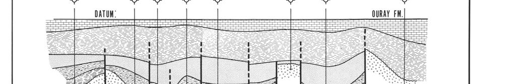
8 104 deposition. Fault blocks that were tensional (grabens) at Ignacio time were compressional (horsts) at Aneth time, and vice versa (fig. 5). The age of the Aneth Formation is considered to be Late Devonian on the basis of fish remains recovered from cores in the type well in southeast Utah (Knight and Cooper, 1955; Parker and Roberts, 1963, 1966; Baars and Campbell, 1968). Elbert Formation The Elbert Formation was named by Cross (1904) for exposures along Elbert Creek north of Rockwood, Colorado. The Elbert Formation conformably overlies the Aneth in the Four Corners region, but disconformably overlies Late Cambrian rocks in most other areas. Knight and Cooper (1955) redefined the Elbert and divided it into two members; the basal McCracken Sandstone Member and an upper dolomite and shale member. The McCracken Sandstone Member is a fine- to mediumgrained, light-gray to red, poorly sorted, glauconitic sandstone containing thin stringers of sandy dolomite. The McCracken is present in the San Juan Mountains, disconformably overlying sandstones of the Cambrian Ignacio Formation (Baars and Knight, 1957) with which it was originally included by Cross, Howe and Ransome (1905). The McCracken grades westward into sandy dolomite and gradually becomes indistinguishable from the undifferentiated Elbert along the western Colorado Plateau (Baars and Campbell, 1968). Lessentine (1965) noted that the source of McCracken sediments was to the east and that numerous facies changes between sandstone, shale and carbonate testify to repeatedly changing conditions of provenance. Baars and Campbell (1968) stated that the McCracken was best developed on the high flanks of paleostructures and graded to sandy dolomite between paleotectonic highs. The apparent structural complexity of northwest New Mexico, as shown in Figures 2 and 6, suggests that Baars and Campbell's (1968) hypothesis can be applied locally, thereby casting some doubt on Lessentine's suggestion of changing conditions of provenance. That the source of McCracken sediments lies to the east is not refuted, but rejuvenation of structural lineaments in northwest New Mexico could also have resulted in drastically changing sedimentation conditions in an area of probable shallowmarine-shelf conditions (fig. 6). There is currently insufficient well control to determine whether, in fact, all of the fractures shown in Figure 6 were active during deposition, but their proximity to isopachous thicks and/or thins is obvious. The upper member of the Elbert Formation consists of green, waxy shale, thin-bedded limestone and dolomite that is commonly sandy, and white glauconitic sandstone. Baars (1966) suggested a tidal-flat environment of deposition on the basis of occurrence of salt casts and stromatolites in outcrops in the San Juan Mountains. The southern limit of recognizable Elbert was not previously extended as far into the San Juan Basin as it is here mapped (fig. 7). However, sample descriptions and mechanicallog characteristics are analogous to those of typical Elbert facies of southwestern Colorado and are considered equivalent. The influence of structural lineaments is still very much apparent in the control of sedimentation of the upper Elbert (figs. 2 and 7). Baars and Campbell (1968) stated that the member overlies Precambrian quartzites with angular unconformity on fault blocks in the San Juan Mountains. Likewise, STEVENSON and BAARS the upper member nonconformably overlies the Precambrian in the extreme southwest corner of Colorado (figs. 5 and 7). Fish fauna, identified as Late Devonian in age, have been found in the upper member of the Elbert in the San Juan Mountains (Baars and Campbell, 1968). Ouray Formation The Ouray Formation was named by Spencer (1900) for ft. of massive limestone at Ouray, Colorado. The Ouray is a dark-brown limestone and dolomite that conformably overlies the Elbert Formation throughout the Colorado Plateau. The Ouray, as here mapped, extends much farther into the San Juan Basin than it was previously mapped (fig. 8). Although no faults dissect the Ouray, the basement lineaments appear to have been reactivated to the extent of continuing to control or influence sedimentation (figs. 5 and 8). The exact age of the Ouray has been the subject of debate in papers by Parker and Roberts (1963, 1966); Baars (1966), and Baars and Campbell (1968), to which the reader is referred for detailed discussion. Locally, the Ouray contains numerous brachiopods, gastropods, crinoids, rugose corals and foraminifera, indicating a marine origin and a generally low-energy environment (Baars, 1966). The Ouray was considered to be of Late Devonian age because of its distinctive Paurorhyncha endlichi (Meek) and Cyrtiopsis animasensis (Girty) brachiopod fauna, until Knight and Baars (1957) suggested a possible Early Missisippian age of part of the Ouray, and Parker and Roberts (1963) reported evidence confirming a basal Mississippian age for the upper Ouray. Baars (1966) reported that cores from several wells in southeast Utah and southwest Colorado contain Kinderhookian (?) endothyrid Foraminifera from the top few feet of the formation. In the southern San Juan Basin, the Ouray could be early Kinderhookian in age, as it is overlain by the Arroyo Periasco Formation of Osage to Meramecian age. Conodonts of Devonian age have recently been found in the Ouray near Rockwood, Colorado. As a compromise to all this confusion, the writers suggest that the formation is diachronous and representative of both geologic periods. The Ouray appears to be Late Devonian (Frasnian) in age in the type locality, and it progressively grades southward into younger rocks of Kinderhookian (?) age


9
10
11
12
13 PRE-CARBONIFEROUS PALEOTECTON ICS in the southern San Juan Basin. In any event, the writers have included the Ouray in the Devonian for purposes of mapping. In the Four Corners area, the Ouray is overlain with apparent conformity by the Kinderhookian to Osagian Leadville Limestone (Baars and Campbell, 1968). PALEOTECTONICS Baars (1966) demonstrated that a large northwest-trending graben consisting of Late Precambrian through Mississippian rocks is exposed in the core of the San Juan Mountains near Silverton, Colorado. It was shown that tectonism was rejuvenated periodically throughout the Paleozoic and that these structural I ineaments actively controlled sedimentation through Mississippian time. Baars further extended these structural relationships into the subsurface of the eastern Paradox basin. This structure was shown to join a major northwest-trending pre-pennsylvanian system of faults along each of the major salt anticlines. Baars (1972) further demonstrated a similar history for the Uncompahgre uplift. Baars (1977) has recently shown that these structural lineaments of the Paradox basin and San Juan Mountains are closely related to a major system of northwest-trending lineaments extending from Vancouver Island, British Columbia, to the Ouachita Mountains of Oklahoma. Much of the evidence indicates that these lineaments have a Late Precambrian origin and that movement along them has recurred periodically. With the ever increasing number of deep wells being drilled, a similar tectonic history is beginning to unfold in the Four Corners region. Although the magnitude of these lineaments is considerably less than for those shown by Baars (1966) in the Paradox basin; they have been paramount in controlling sedimentation in the San Juan Basin from Cambrian through Devonian time, and possibly throughout the entire Phanerozoic. Tectonic lineaments were present by Late Cambrian time, controlling sedimentation in the northwestern San Juan Basin (fig. 3). The isolated remnants of the Ignacio Formation suggest that the topographic expression of the structures was well developed prior to deposition of Ignacio sediments (figs. 2, 3 and 5). Although precise dating on movement of these ancient fractures is unclear, a relative age of movement can be determined by stratigraphic sequence. Displacement could have begun during Late Precambrian time and extended into the Devonian until deposition of the Aneth Formation. However, the general lack of erosional effects at the top of the Ignacio suggests relative quiescence from Late Cambrian through Middle Devonian time, thereby suggesting that movement might actually have been syndepositional with the Ignacio. Late Devonian rejuvenation of the ancient fractures occurred prior to deposition of the Aneth Formation, as shown in Stage II in Figure 5. The resulting down-thrown fault blocks were not entirely the same as those at Ignacio time; that is, what appeared as Cambrian horst blocks (Stage I) were grabens by Aneth time (Stage II, fig. 5; also figs. 2 and 4). This oscillatory movement of the fracture system apparently continued through the close of the Devonian, as isopachous trends in the McCracken, upper member of the Elbert, and Ouray reflect the influence these structures had on controlling sedimentation, at least locally, in northwest New Mexico (figs. 6, 7 and 8). PETROLEUM OCCURRENCES 109 Although rocks of Cambrian and Devonian age have yielded only slight amounts of oil and gas in the San Juan Basin, the production is apparently related to these ancient structural features. A delicate paleotectonic balance controlled reservoir development along these fractures. Potential reservoirs may have been removed by erosion if the structural relief became too great, either during or shortly after deposition. Apparently, the only fault block that withstood this delicate balance of structure and sedimentation was in the Beautiful Mountain area. Here, the Akah Nez field has produced 17,199 BO from the McCracken and Ignacio (?). Several wells in the near vicinity had favorable drill stem tests but were plugged, probably due to unfavorable economic conditions. In the future, geologists exploring in the San Juan Basin for early Paleozoic hydrocarbon reservoirs should make every effort to reconstruct the paleotectonic history of the area as it relates to the control of lithofacies and reservoir development. One must go back to the original depositional basin to understand oil occurrences. CONCLUSIONS Structural and stratigraphic relations of Cambrian and Devonian strata in the northwest portion of the San Juan Basin suggest that this area has had a long history of tectonism and that the Four Corners platform may not have always been as stable as has been previously conjectured. Sufficient well control is currently available in the northwest corner of New Mexico to suggest that basement structures were episodically active throughout the lower Paleozoic and were responsible for controlling sedimentation. Once these paleotectonic features are understood, they can be compared to other less understood areas in the central San Juan Basin. A discussion of the mechanics of these structures is beyond the scope and physical limitations of this paper, but will be forthcoming in the near future. However, some interesting observations can be made at this time: (1) Block faulting of the basement appears to be present in the northwest and southeast portions of the San Juan Basin; these are not simple tensional features because individual fault blocks can be shown to oscillate through time from tensional normal faults to compressional reverse faults and back to normal faults (fig. 5). (2) The magnitude of vertical displacement along these faults is small, but sufficient to control sedimentation (figs. 3, 4, 6, 7 and 8). (3) Because of the minor amount of vertical movement that is apparent, it would be more descriptive perhaps, to refer to these structures as "fractures" or "megafractures." (4) The apparent northwest-southeast trend of lineaments suggests a close relationship to the larger Uncompahgre tectonism which originated in the Precambrian (Baars, 1966). (5) The northwest-trending lineations of the fractures in the northwest and southeast San Juan Basin strongly suggest that similar lineations are present in the central San Juan Basin, but stratigraphic control is so sparse that, at present, they are only conjectural. (6) The alternating up-and-down "yoyo tectonics" (fig. 5) are typical criteria for wrench or strike-slip faulting. Baars (1977) has demonstrated how large-scale hori-
14 110 zontal compressional forces can create local vertical tensional features in the Colorado Plateau. REFERENCES Baars, D. L., 1958, Cambrian stratigraphy of the Paradox basin region: Intermtn. Assoc. Petroleum Geologists, 9th Ann. Field Conf. Guidebook, p , Pre-Pennsylvanian paleotectonics-key to basin evolution and petroleum occurrences in Paradox basin, Utah and Colorado: Am. Assoc. Petroleum Geologists Bull., v. 50, no. 10, p , Pre-Pennsylvanian paleotectonic framework of Ancestral Rockies of Colorado [abs.] : Colo. School Mines Quart., v. 67, no. 4, p , The Colorado Plateau aulogogen-key to continental scale basement rifting: 2nd International Conf. on the New Basement Tectonics Proc. (in press). Baars, D. L., and Knight, R. L., 1957, Pre-Pennsylvanian stratigraphy of the San Juan Mountains and Four Corners area: New Mexico Geol. Soc. Guidebook, 8th Field Conf., p Baars, D. L., and Campbell, J. A., 1968, Devonian System of Colorado, northern New Mexico and the Colorado Plateau: Rocky Mtn. Assoc. Geologists, v. 5, p Barnes, Harley, 1954, Ignacio quartzite in southwestern Colorado: Am. Assoc. Petroleum Geologists Bull., v. 38, p STEVENSON and BAARS Cross, Whitman, 1904, A new Devonian formation in Colorado: Am. Jour. Sci., 4th Ser., v. 18, p Cross, Whitman, Howe, Ernest and Ransome, F. L., 1905, Silverton, Colorado: U.S. Geol. Survey Folio 120. Knight, R. L., and Baars, D. L., 1957, New developments on age and extent of Ouray limestone [Colorado Plateau] : Am. Assoc. Petroleum Geologists Bull., v. 41, no. 10, p Knight, R. L., and Cooper, J. C., 1955, Suggested changes in Devonian terminology of the Four Corners area: Four Corners Geol. Soc., 1st Ann. Field Conf. Guidebook, p Lessentine, R. H., 1965, Kaiparowits and Black Mesa basins-stratigraphic synthesis: Am. Assoc. Petroleum Geologists Bull., v. 49, no. 11, p Parker, J. W. and Roberts, J. W., 1963, Devonian and Mississippian stratigraphy of the central part of the Colorado Plateau, in Shelf Carbonates of the Paradox Basin-Symposium: Four Corners Geol. Soc., 4th Ann. Field Conf. Guidebook, p , Regional Devonian and Mississippian stratigraphy, central Colorado Plateau: Am. Assoc. Petroleum Geologists Bull., v. 50, no. 11, p Rhodes, F. H. T., and Fisher, J. H., 1957, Ignacio quartzite of southwestern Colorado: Am. Assoc. Petroleum Geologists Bull., v. 41, p Spencer, A. C., 1900, Devonian strata in Colorado: Am. Jour. Sci., 4th Ser., v. 9, p
New Mexico Geological Society
 New Mexico Geological Society Downloaded from: http://nmgs.nmt.edu/publications/guidebooks/43 Volcanic geology of the Rio Puerco necks R. Bruce Hallett, 1992, pp. 135-144 in: San Juan Basin IV, Lucas,
New Mexico Geological Society
 New Mexico Geological Society Downloaded from: http://nmgs.nmt.edu/publications/guidebooks/19 Pennsylvanian correlations in southwestern Colorado Sherman A. Wengerd and Ernest Szabo, 1968, pp. 159-164
New Mexico Geological Society
 New Mexico Geological Society Downloaded from: http://nmgs.nmt.edu/publications/guidebooks/29 Laramide thrust faulting, Klondike Hills, southwestern New Mexico LeRoy L. Corbitt, F. L. Nials, and R. J.
New Mexico Geological Society
 New Mexico Geological Society Downloaded from: http://nmgs.nmt.edu/publications/guidebooks/25 Structure of the Guadalupe Box area, Sandoval County, New Mexico Harvey R. DuChene, 1974, pp. 131-135 in: Ghost
New Mexico Geological Society
 New Mexico Geological Society Downloaded from: http://nmgs.nmt.edu/publications/guidebooks/33 Paleozoic history of the Albuquerque trough--implications for basement control on the Rio Grande rift Donald
New Mexico Geological Society
 New Mexico Geological Society Downloaded from: http://nmgs.nmt.edu/publications/guidebooks/26 Direct-current soundings on the La Mesa surface near Kilbourne and Hunts Holes, New Mexico Dallas B. Jackson
Structural Styles and Geotectonic Elements in Northwestern Mississippi: Interpreted from Gravity, Magnetic, and Proprietary 2D Seismic Data
 Structural Styles and Geotectonic Elements in Northwestern Mississippi: Interpreted from Gravity, Magnetic, and Proprietary 2D Seismic Data Nick Loundagin 1 and Gary L. Kinsland 2 1 6573 W. Euclid Pl.,
New Mexico Geological Society
 New Mexico Geological Society Downloaded from: http://nmgs.nmt.edu/publications/guidebooks/26 Tectonic significance of the Pony Hills, Luna County, New Mexico LeRoy L. Corbitt and Fred L. Nials, 1975,
New Mexico Geological Society
 New Mexico Geological Society Downloaded from: http://nmgs.nmt.edu/publications/guidebooks/35 Structural anomalies in the Espanola Basin Bruce A. Black, 1984, pp. 59-62 in: Rio Grande Rift (Northern New
New Mexico Geological Society
 New Mexico Geological Society Downloaded from: http://nmgs.nmt.edu/publications/guidebooks/13 Paleontological reconnaissance of subsurface Pennsylvanian in southern pache and Navajo Counties, rizona Donald
New Mexico Geological Society
 New Mexico Geological Society Downloaded from: http://nmgs.nmt.edu/publications/guidebooks/30 Structure and stratigraphy of the Hagan embayment--a new look Bruce A. Black, 1979, pp. 101-105 in: Santa Fe
The Problem of the Welden, Sycamore and Lower Caney in the Eastern Arbuckle Mountains
 120 PROC. OF THE OKLA. ACAD. OF SCI. FOR 1958 The Problem of the Welden, Sycamore and Lower Caney in the Eastern Arbuckle Mountains STEVE C. CHAMPLIN, University of Oklahoma, Norman This paper is a preliminary
GY 112L Earth History
 GY 112L Earth History Lab 2 Vertical Successions and Sequences of Events GY 112L Instructors: Douglas Haywick, James Connors, Mary Anne Connors Department of Earth Sciences, University of South Alabama
Overview of Selected Shale Plays in New Mexico*
 Overview of Selected Shale Plays in New Mexico* Ron Broadhead 1 Search and Discovery Article #10627 (2014)** Posted August 18, 2014 *Adapted from presentation at RMAG luncheon meeting, Denver, Colorado,
The McCully gas field in southern New Brunswick was discovered in the year 2000 on a joint drilling exploration venture by Corridor Resources Inc.
 1 The McCully gas field in southern New Brunswick was discovered in the year 2000 on a joint drilling exploration venture by Corridor Resources Inc. and Potash Corporation of Saskatchewan. Located about
New Mexico Geological Society
 New Mexico Geological Society Downloaded from: http://nmgs.nmt.edu/publications/guidebooks/9 Summary of coal resources of the Black Mesa coal field, Arizona R. B. O'Sullivan, 1958, pp. 169-171 in: Black
New Mexico Geological Society
 New Mexico Geological Society Downloaded from: http://nmgs.nmt.edu/publications/guidebooks/19 Vanadium deposits of the Placerville area, San Miguel County, Colorado R. P. Fischer, 1968, pp. 100-103 in:
New Mexico Geological Society
 New Mexico Geological Society Downloaded from: http://nmgs.nmt.edu/publications/guidebooks/27 Structural framework of the southern Raton Basin, New Mexico Lee A. Woodward and D. O. Snyder, 1976, pp. 125-127
New Mexico Geological Society
 New Mexico Geological Society Downloaded from: http://nmgs.nmt.edu/publications/guidebooks/32 Rio Blanco Oil Shale Company Tract C-a, Rio Blanco County, Colorado: Summary of geology and current development
Structural Geology of the Mountains
 Structural Geology of the Mountains Clinton R. Tippett Shell Canada Limited, Calgary, Alberta clinton.tippett@shell.ca INTRODUCTION The Southern Rocky Mountains of Canada (Figure 1) are made up of several
THE NEW HARMONY GROUP (LOWER DEVONIAN)
") 2001. Proceedings of the Indiana Academy of Science 1 10:23-27 THE NEW HARMONY GROUP (LOWER DEVONIAN) REVISITED 1 John B. Droste and Alan S. Horowitz Department of Geological Sciences, Indiana : University,
2001. Proceedings of the Indiana Academy of Science 1 10:23-27 THE NEW HARMONY GROUP (LOWER DEVONIAN) REVISITED 1 John B. Droste and Alan S. Horowitz Department of Geological Sciences, Indiana : University,
THE STRUCTURE AND THICKNESS OF THE CLINTON AND BEREA FORMATIONS IN THE VICINITY OF WOOSTER, OHIO
 THE STRUCTURE AND THICKNESS OF THE CLINTON AND BEREA FORMATIONS IN THE VICINITY OF WOOSTER, OHIO KARL VER STEEG College of Wooster INTRODUCTION AND ACKNOWLEDGMENTS The data used in the construction of
New Mexico Geological Society
 New Mexico Geological Society Downloaded from: http://nmgs.nmt.edu/publications/guidebooks/32 Summary of Paleozoic stratigraphy and history of western Colorado and eastern Utah John A. Campbell, 1981,
New Mexico Geological Society
 New Mexico Geological Society Downloaded from: http://nmgs.nmt.edu/publications/guidebooks/27 Subsurface Paleozoic stratigraphy of the northeastern New Mexico basin and arch complex J. Wayland Roberts,
Answers: Internal Processes and Structures (Isostasy)
") Answers: Internal Processes and Structures (Isostasy) 1. Analyse the adjustment of the crust to changes in loads associated with volcanism, mountain building, erosion, and glaciation by using the concept
Answers: Internal Processes and Structures (Isostasy) 1. Analyse the adjustment of the crust to changes in loads associated with volcanism, mountain building, erosion, and glaciation by using the concept
New Mexico Geological Society
 New Mexico Geological Society Downloaded from: http://nmgs.nmt.edu/publications/guidebooks/18 Geomorphology and structure in the Grants mineral belt Robert A. Laverty, 1967, pp. 188-194 in: Defiance, Zuni,
Controls on facies distributions in the Charlie Lake Formation, Peace River Arch, Alberta
 Controls on facies distributions in the Charlie Lake Formation, Peace River Arch, Alberta E.L. Percy 12, C. Frostad 2, A. Juska 2, C. Schmidt 2, C. Sitzler 2, and J.P. Zonneveld 3 University of Calgary,
Pennsylvanian sinistral faults along the southwest boundary of the Uncompahgre uplift, Ancestral Rocky Mountains, Colorado
 Pennsylvanian sinistral s along the southwest boundary of the Uncompahgre uplift, Ancestral Rocky Mountains, Colorado William A. Thomas* Department of Geological Sciences, University of Kentucky, Lexington,
Iowa s Precambrian and Cambrian. University of Northern Iowa Dr. Chad Heinzel
 Iowa s Precambrian and Cambrian University of Northern Iowa Dr. Chad Heinzel Concept of Geologic Formations A body/layer of rock that consists dominantly of a certain lithologic rock type Maybe combined
New Mexico Geological Society
 New Mexico Geological Society Downloaded from: http://nmgs.nmt.edu/publications/guidebooks/9 Pennsylvanian paleogeography of Arizona Kay Havenor and Willard D. Pyr, 1958, pp. 78-81 in: Black Mesa Basin
New Mexico Geological Society
 New Mexico Geological Society Downloaded from: http://nmgs.nmt.edu/publications/guidebooks/34 Recent measurements of crustal deformation related to the Socorro magma body, New Mexico Shawn Larsen and Robert
Structural Geology Lab. The Objectives are to gain experience
 Geology 2 Structural Geology Lab The Objectives are to gain experience 1. Drawing cross sections from information given on geologic maps. 2. Recognizing folds and naming their parts on stereoscopic air
L.O: HOW GEOLOGISTS SEQUENCE EVENTS IN EARTH'S GEOLOGIC HISTORY IF NOT OVERTURNED, OLDEST ON BOTTOM, YOUNGEST ON TOP
 L.O: HOW GEOLOGISTS SEQUENCE EVENTS IN EARTH'S GEOLOGIC HISTORY IF NOT OVERTURNED, OLDEST ON BOTTOM, YOUNGEST ON TOP 1. Unless a series of sedimentary rock layers has been overturned, the bottom rock layer
APPENDIX C GEOLOGICAL CHANCE OF SUCCESS RYDER SCOTT COMPANY PETROLEUM CONSULTANTS
 APPENDIX C GEOLOGICAL CHANCE OF SUCCESS Page 2 The Geological Chance of Success is intended to evaluate the probability that a functioning petroleum system is in place for each prospective reservoir. The
GLY 155 Introduction to Physical Geology, W. Altermann. Press & Siever, compressive forces. Compressive forces cause folding and faulting.
 Press & Siever, 1995 compressive forces Compressive forces cause folding and faulting. faults 1 Uplift is followed by erosion, which creates new horizontal surface. lava flows Volcanic eruptions cover
EAS 233 Geologic Structures and Maps Winter Miscellaneous practice map exercises. 1. Fault and separation:
 Miscellaneous practice map exercises 1. Fault and separation: With respect to Map 1, what are (a) the orientation of the fault, and (b) the orientation of bedding in the units cut by the fault. (c) Mark
Seismic stratigraphy, some examples from Indian Ocean, interpretation of reflection data in interactive mode
 Seismic stratigraphy, some examples from Indian Ocean, interpretation of reflection data in interactive mode K. S. Krishna National Institute of Oceanography, Dona Paula, Goa-403 004. krishna@nio.org Seismic
LITHOLOGIC FACIES OF A PORTION OF THE STILLWATER FORMATION DON B. GOULD
 118 PROCEEDINGS OF THE OKLAHOMA a LITHOLOGIC FACIES OF A PORTION OF THE STILLWATER FORMATION DON B. GOULD University of Iowa, Iowa City, Iowa The Permian rocks of the world are noted for their unusual
GEOLOGY MEDIA SUITE Chapter 8
 UNDERSTANDING EARTH, SIXTH EDITION GROTZINGER JORDAN GEOLOGY MEDIA SUITE Chapter 8 Clocks in Rocks Timing the Geologic Record 2010 W.H. Freeman and Company Stratigraphy and fossils Figure 8.4 (page 172)
Hydrocarbon Pools Of The Southeastern Great Slave Plain, Northwest Territories
 Hydrocarbon Pools Of The Southeastern Great Slave Plain, Northwest Territories Introduction E.P. Janicki* C.S. Lord Northern Geoscience Centre, Yellowknife, NWT ed_janicki@gov.nt.ca The geology of hydrocarbon
Case Study of the Structural and Depositional-Evolution Interpretation from Seismic Data*
 Case Study of the Structural and Depositional-Evolution Interpretation from Seismic Data* Yun Ling 1, Xiangyu Guo 1, Jixiang Lin 1, and Desheng Sun 1 Search and Discovery Article #20143 (2012) Posted April
USGS: USGS: NEIC NEIC
 Triggered Earthquakes in North-Central Arkansas and their Relationship to Class II UIC Wells Scott M. Ausbrooks, The Arkansas Geological Survey Steve Horton, Ph.D., CERI at University i of Memphis Contributors:
New Mexico Geological Society
 New Mexico Geological Society Downloaded from: http://nmgs.nmt.edu/publications/guidebooks/23 Structural interpretation of the fractures associated with the Bonita Fault D. W. Stearns, 1972, pp. 161-164
Page 1. Name:
 Name: Questions 1 through 3 refer to the following: The diagrams below represent two rock outcrops found several miles apart in New York State. Individual rock layers are lettered, and fossils and rock
Dakota Sandstone. of the Moxa Arch and Surrounding Green River Basin
 Dakota Sandstone of the Moxa Arch and Surrounding Green River Basin Dakota Sandstones of the Green River Basin Overview The Dakota sandstones of the Moxa Arch and surrounding Green River Basin remain attractive
FY 2013 Annual Technical Report for NCRDS State Cooperative Program
 FY 2013 Annual Technical Report for NCRDS State Cooperative Program SUBSURFACE GAS-SHALE SAMPLES OF THE UPPER DEVONIAN AND LOWER MISSISSIPPIAN WOODFORD SHALE, PERMIAN BASIN, WEST TEXAS AND SOUTHEASTERN
Geological History of the Grand Canyon
 Geological History of the Grand Canyon For a copy of this assignment, print a copy of this web page. The Project Your job is to write a short paper that describes the geological history of the Grand Canyon
New Mexico Geological Society
 New Mexico Geological Society Downloaded from: http://nmgs.nmt.edu/publications/guidebooks/25 Outline of the igneous geology of the Jemez Mountain volcanic field A. M. Kudo, 1974, pp. 287-289 in: Ghost
New Mexico Geological Society
 New Mexico Geological Society Downloaded from: http://nmgs.nmt.edu/publications/guidebooks/28 Geohydrology of the Westwater Canyon Member, Morrison Formation, of the southern San Juan Basin, New Mexico
Plate tectonics model for the continental collisions during Late Paleozoic
 Alleghanian orogeny During Late Paleozoic, northwestern Africa collided with southeastern North America, causing the Alleghanian orogeny, and building the Appalachian mountains. The orogeny began during
The Geology of Two Lights State Park. Cape Elizabeth, Maine
 Maine Geologic Facts and Localities June, 2002 Cape Elizabeth, Maine 43 33 33.48 N, 70 12 13.32 W Text by Henry N. Berry IV and Robert G. Marvinney, Department of Agriculture, Conservation & Forestry 1
IP 121 ILLINOIS PETROLEUJM Illinois Institute of Natdral Resources STATE GEOWGICA SURVEY DIVISION' Jack A. Simon. Chief
 IP 121 ILLINOIS PETROLEUJM 121 1981 Illinois Institute of Natdral Resources STATE GEOWGICA SURVEY DIVISION' Jack A. Simon. Chief Stevenson, D. L. (David L.) Geologic structure of the base of the New Albany
Timing, style, and significance of Cambrian through Laramide brittle reactivation along the Proterozoic Homestake shear zone, Colorado mineral belt
 Timing, style, and significance of Cambrian through Laramide brittle reactivation along the Proterozoic Homestake shear zone, Colorado mineral belt Joseph L. Allen Department of Geology and Physical Sciences,
New Mexico Geological Society
 New Mexico Geological Society Downloaded from: http://nmgs.nmt.edu/publications/guidebooks/28 Influences of structure on Jurassic depositional patterns and uranium occurrences, northwestern New Mexico
Ministry of Oil and Minerals Petroleum Exploration & Production Authority BLOCK 6 (Iryam)
") Ministry of Oil and Minerals Petroleum Exploration & Production Authority BLOCK 6 (Iryam) The Iryam Block (6) occupies an area of 3,911 km 2 in the Sabatayn Basin in the province of Shabwah in central
Ministry of Oil and Minerals Petroleum Exploration & Production Authority BLOCK 6 (Iryam) The Iryam Block (6) occupies an area of 3,911 km 2 in the Sabatayn Basin in the province of Shabwah in central
Ministry of Oil and Minerals Petroleum Exploration & Production Authority BLOCK 85 (Al Uqlah North)
") Ministry of Oil and Minerals Petroleum Exploration & Production Authority BLOCK 85 (Al Uqlah North) The Al Uqlah North Block (85) occupies an area of 597 km 2 in the Sabatayn Basin in the province of Shabwah
Ministry of Oil and Minerals Petroleum Exploration & Production Authority BLOCK 85 (Al Uqlah North) The Al Uqlah North Block (85) occupies an area of 597 km 2 in the Sabatayn Basin in the province of Shabwah
NAME HOMEWORK ASSIGNMENT #3 MATERIAL COVERS CHAPTERS 8, 9, 10, 11
 NAME HOMEWORK ASSIGNMENT #3 MATERIAL OVERS HAPTERS 8, 9, 10, 11 Assignment is due the beginning of the class period on November 23, 2004. Answers for each chapter will be discussed in class, as Exam #3
Petroleum possibilities of the Cuervo trough, Tucumcari Basin, New Mexico
 Petroleum possibilities of the Cuervo trough, Tucumcari Basin, New Mexico Charles B. Reynolds and Irene B. Reynolds Geological Associates, 4409 San Andres NE, Albuquerque, New Mexico 87110 Abstract One
New Mexico Geological Society
 New Mexico Geological Society Downloaded from: http://nmgs.nmt.edu/publications/guidebooks/32 Potential petroleum resources of northeastern Utah and northwestern Colorado Albert F. Sanborn, 1981, pp. 255-266
SOUTHWESTERN SAN JUAN MOUNTAINS COLORADO EIGHTH FIELD CONFERENCE SEPTEMBER 5, 6 & 7, 1957
 NEW MEXICO GEOLOGICAL SOCIETY Guidebook I OF SOUTHWESTERN SAN JUAN MOUNTAINS COLORADO EIGHTH FIELD CONFERENCE SEPTEMBER 5, 6 & 7, 1957 N E W M E X I C O G E O L O G I C A L S O C I E T Y * E I G H T H
Unit 5: Earth s History Practice Problems
 Name: Date: 1. Which bedrock would be most likely to contain fossils? A. Precambrian granite B. Cambrian shale C. Pleistocene basalt D. Middle-Proterozoic quartzite 6. Base your answer(s) to the following
New Mexico Geological Society
 New Mexico Geological Society Downloaded from: http://nmgs.nmt.edu/publications/guidebooks/32 Geology of the Lisbon Valley Uranium district, southeastern Utah Gary C. Huber, 1981, pp. 177-182 in: Western
Copyright McGraw-Hill Education. All rights reserved. No reproduction or distribution without the prior written consent of McGraw-Hill Education
 Copyright McGraw-Hill Education. All rights reserved. No reproduction or distribution without the prior written consent of McGraw-Hill Education Tibetan Plateau and Himalaya -southern Asia 11.00.a VE 10X
Your web browser (Safari 7) is out of date. For more security, comfort and the best experience on this site: Update your browser Ignore
 is out of date. For more security, comfort and the best experience on this site: Update your browser Ignore") Your web browser (Safari 7) is out of date. For more security, comfort and the best experience on this site: Update your browser Ignore BEDRO CK For the complete encyclopedic entry with media resources,
Your web browser (Safari 7) is out of date. For more security, comfort and the best experience on this site: Update your browser Ignore BEDRO CK For the complete encyclopedic entry with media resources,
Exploring Geology Chapter 9 Geologic Time
 Exploring Geology Chapter 9 Geologic Time Copyright The McGraw-Hill Companies, Inc. Permission required for reproduction or display. Chapter 9: Geologic Time Stratigraphic Principles Relative Age Dating
Deep Time: How Old Is Old?
 Deep Time: How Old Is Old? Updated by: Rick Oches, Professor of Geology & Environmental Sciences Bentley University Waltham, Massachusetts Based on slides prepared by: Ronald L. Parker, Senior Geologist
Petroleum Systems (Part One) Source, Generation, and Migration
 Source, Generation, and Migration") Petroleum Systems (Part One) Source, Generation, and Migration GEOL 4233 Class January 2008 Petroleum Systems Elements Source Rock Migration Route Reservoir Rock Seal Rock Trap Processes Generation Migration
Petroleum Systems (Part One) Source, Generation, and Migration GEOL 4233 Class January 2008 Petroleum Systems Elements Source Rock Migration Route Reservoir Rock Seal Rock Trap Processes Generation Migration
Lecture 24: Paleozoic 1:
 UNIVERSITY OF SOUTH ALABAMA GY 112: Earth History Lecture 24: Paleozoic 1: Laurentia Instructor: Dr. Douglas W. Haywick Last Time (before the exam) The Cambrian Explosion A) Why a Cambrian explosion B)
Unconformities are depositional contacts that overlie rocks distinctly older than they are. They are often called gaps in the sedimentary record.
 UNCONFORMITIES Unconformities are depositional contacts that overlie rocks distinctly older than they are. They are often called gaps in the sedimentary record. The contact represents time when no sediment
Before the 1700 s, scientists thought that the Earth was only 6,000 years old. This mindset was based on biblical references.
 Before the 1700 s, scientists thought that the Earth was only 6,000 years old. This mindset was based on biblical references. However, as scientists began to better understand the processes that shape
Lab 4: Structures and Geologic Maps
 Key Questions: GEOL 1311 Earth Science Lab 4 Structures and Geologic Maps What shapes do rock bodies take in the Earth? How do two-dimensional visualizations of the Earth, such as maps and cross-sections
Follow this and additional works at: Part of the Geology Commons
 Western Michigan University ScholarWorks at WMU Michigan Geological Repository for Research and Education Geosciences 2016 Geology of Michigan William B. Harrison III Michigan Geological Repository for
Robert S. Sawin Stratigraphic Research Section Kansas Geological Survey. Open-File Report
 Copies of Archived Correspondence Pertinent to the Decision to Classify the Exposure at Point of Rocks, Morton County, Kansas, as Jurassic by the Kansas Geological Survey in 1967 Robert S. Sawin Stratigraphic
Seismic Data and Drilling in Hancock Co., Kentucky February 21, 2008
 Seismic Data and Drilling in Hancock Co., Kentucky February 21, 2008 J.A. Drahovzal 2/21/08 1 Hancock County (H1) Information Provided at 2/7/08 Meeting Depth of Top (t) and Thickness (th) in feet t Kn
Geologic and Rock Cycles, Fossils and Unconformities
 Geologic and Rock Cycles, Fossils and Unconformities The Geologic Cycle 3 key events: deposition, uplift, erosion Sedimentation of beds A-D beneath the sea Uplift above sea level and exposure of D to erosion
Rock cycle diagram. Relative dating. Placing rocks and events in proper sequence of formation Deciphering Earth s history from clues in the rocks
 Geologic Time Rock cycle diagram Leaves of History Chapter 21 Modern geology Uniformitarianism Fundamental principle of geology "The present is the key to the past Relative dating Placing rocks and events
Plan of Development Mountain Valley Pipeline Project. APPENDIX P Plan for Unanticipated Discovery of Paleontological Resources
 APPENDIX P Plan for Unanticipated Discovery of Paleontological Resources Appendix P Plan for Unanticipated Discovery of Paleontological Resources Prepared by: TABLE OF CONTENTS 1.0 INTRODUCTION... 1 1.1
Earth Science, (Tarbuck/Lutgens) Chapter 10: Mountain Building
 Chapter 10: Mountain Building") Earth Science, (Tarbuck/Lutgens) Chapter 10: Mountain Building 1) A(n) fault has little or no vertical movements of the two blocks. A) stick slip B) oblique slip C) strike slip D) dip slip 2) In a(n) fault,
Earth Science, (Tarbuck/Lutgens) Chapter 10: Mountain Building 1) A(n) fault has little or no vertical movements of the two blocks. A) stick slip B) oblique slip C) strike slip D) dip slip 2) In a(n) fault,
Depositional History and Petroleum Potential of Ombilin Basin, West Sumatra - Indonesia, Based on Surface Geological Data*
 Depositional History and Petroleum Potential of Ombilin Basin, West Sumatra - Indonesia, Based on Surface Geological Data* Yahdi Zaim 1, Litto Habrianta 2, Chalid I. Abdullah 1, Aswan 1, Yan Rizal 1, Nurcahyo
MUHAMMAD S TAMANNAI, DOUGLAS WINSTONE, IAN DEIGHTON & PETER CONN, TGS Nopec Geological Products and Services, London, United Kingdom
 Geological and Geophysical Evaluation of Offshore Morondava Frontier Basin based on Satellite Gravity, Well and regional 2D Seismic Data Interpretation MUHAMMAD S TAMANNAI, DOUGLAS WINSTONE, IAN DEIGHTON
Before the 1700 s, scientists thought that the Earth was only 6,000 years old. This mindset was based on biblical references.
 Before the 1700 s, scientists thought that the Earth was only 6,000 years old. This mindset was based on biblical references. However, as scientists began to better understand the processes that shape
Sequence Biostratigraphy and Depositional Modelling of the Pennsylvanian-Permian Belloy Formation Peace River Embayment, Alberta Canada
 Page No. 104-1 Sequence Biostratigraphy and Depositional Modelling of the Pennsylvanian-Permian Belloy Formation Peace River Embayment, Alberta Canada Lindsay A. Dunn* and Charles M. Henderson Applied
Determining geological ages
 Determining geological ages Relative ages placing rocks and geologic events in their proper sequence, oldest to youngest. Absolute dates define the actual numerical age of a particular geologic event.
1 Hfli. ^^Hi. 11 mw\i. mmsisi i lull I. IMMRrtHttiifHmiititlK. RibWh. llml ''.' 1 ffililsiillsll8 ill. iiiinitsim IK«
 l i. :,, v. i :! 1.» r =,
High-resolution Sequence Stratigraphy of the Glauconitic Sandstone, Upper Mannville C Pool, Cessford Field: a Record of Evolving Accommodation
 Page No. 069-1 High-resolution Sequence Stratigraphy of the Glauconitic Sandstone, Upper Mannville C Pool, Cessford Field: a Record of Evolving Accommodation Thérèse Lynch* and John Hopkins, Department
Upper Viséan (Meramecian-Chesterian) Conodont Biostratigraphy of the SW Ozarks of NW Oklahoma, SW Missouri, and NW Arkansas
 Conodont Biostratigraphy of the SW Ozarks of NW Oklahoma, SW Missouri, and NW Arkansas") Upper Viséan (Meramecian-Chesterian) Conodont Biostratigraphy of the SW Ozarks of NW Oklahoma, SW Missouri, and NW Arkansas Cory J. Godwin 1 and James O. Puckette 2 1 Consulting Geologist, Tulsa, Oklahoma,
Upper Viséan (Meramecian-Chesterian) Conodont Biostratigraphy of the SW Ozarks of NW Oklahoma, SW Missouri, and NW Arkansas Cory J. Godwin 1 and James O. Puckette 2 1 Consulting Geologist, Tulsa, Oklahoma,
RELINQUISHMENT REPORT. License P1546 Block April 2009
 RELINQUISHMENT REPORT License P1546 Block 110-01 14 April 2009 Sherritt International Oil and Gas Limited 2000, 425-1 st street S.W., Calgary, Alberta Canada T2P 3L8 Telephone (403) 260-2900 Fax (403)
Hydrocarbon Exploration of Mesozoic in Kutch Offshore Area
 6 th International Conference & Exposition on Petroleum Geophysics Kolkata 2006 Hydrocarbon Exploration of Mesozoic in Kutch Offshore Area Ram Krishna Singh 1, R.C. Agrawalla 2, D. P. Verma 3, A. K. Goel
When last we left off. Western Cordillera NA. Cretaceous. Cretaceous, continued. Cretaceous to present
 When last we left off Western Cordillera NA Cretaceous to present Wild and weird things happened in the murky past of the Archean and precambrian Cambrian through Devonian development of deep water sediments
Origin and Evolution of Formation Waters in the West-Central Part of the Alberta Basin
 Page No. 004-1 Origin and Evolution of Formation Waters in the West-Central Part of the Alberta Basin Karsten Michael* University of Alberta, 1-26 ESB, Edmonton, AB T6G 2E3 karsten@ualberta.ca and Stefan
Seismic Stratigraphy of the Fang Basin, Chiang Mai, Thailand Rungsun Nuntajun
 Chiang Mai J. Sci. 2009; 36(1) 77 Chiang Mai J. Sci. 2009; 36(1) : 77-82 www.science.cmu.ac.th/journal-science/josci.html Contributed Paper Seismic Stratigraphy of the Fang Basin, Chiang Mai, Thailand
Rock cycle diagram. Principle of Original Horizontality. Sediment is deposited horizontally
 Geologic Time Rock cycle diagram Leaves of History Chapter 21 Lateral Continuity Principle of Original Horizontality Sediment is deposited horizontally Principle of Superposition Oldest rock A Younger
Devonian Petroleum Systems and Exploration Potential, Southern Alberta, Part 3 Core Conference
 Devonian Petroleum Systems and Exploration Potential, Southern Alberta, Part 3 Core Conference Andy Mort (1), Leonard Stevens (2), Richard Wierzbicki (2) Abstract Part 1: Devonian Petroleum Systems Dr.
4. Carboniferous Zone Play Results
 C H A P T E R F O U R 4. Carboniferous Zone Play Results 4. Geological Overview In the WCSB, there were two main depositional areas during Carboniferous time the Peace River Embayment in northwestern Alberta,
Downloaded 09/15/16 to Redistribution subject to SEG license or copyright; see Terms of Use at
 A Full Field Static Model of the RG-oil Field, Central Sirte Basin, Libya Abdalla Abdelnabi*, Kelly H. Liu, and Stephen Gao Missouri University of Science and Technology Summary Cambrian-Ordovician and
Stratigraphic Plays in Active Margin Basin: Fluvio-Deltaic Reservoir Distribution in Ciputat Half Graben, Northwest Java Basin*
 Stratigraphic Plays in Active Margin Basin: Fluvio-Deltaic Reservoir Distribution in Ciputat Half Graben, Northwest Java Basin* Ary Wahyu Wibowo 1, Astri Pujianto 1, Wisnu Hindadari 1, Arief Wahidin Soedjono
In this lab, we will study and analyze geologic maps from a few regions, including the Grand Canyon, western Wyoming, and coastal California.
 Name: Lab Section: work in groups, but each person turns in his/her own GEOSCIENCE 001 LAB UNDERSTANDING GEOLOGIC MAPS Geologic maps are colorful and even beautiful, but they also contain an amazing amount
ENGLE COAL FIELD. David E. Tabet
 OPEN FILE REPORT 115 SUMMARY OF THE GEOLOGY OF THE ENGLE COAL FIELD by David E. Tabet THE ENGLE COAL FIELD Introduction The Engle coal field (Lee, 1905), named for the small town of Engle along the Santa
SAMPLE QUESTIONS FOR GEOLOGY 103, TEST 1
 SAMPLE QUESTIONS FOR GEOLOGY 103, TEST 1 The correct answers are listed at the bottom (no peeking!). These questions are to give you an idea of the type of questions that will be asked. They are not a
Cenozoic Extensional Basin Development and Sedimentation in SW Montana
 Cenozoic Extensional Basin Development and Sedimentation in SW Montana Robert C. Thomas Department of Environmental Sciences, The University of Montana Western, Dillon, MT 59725, (406) 683-7615, r_thomas@umwestern.edu