Structural Styles and Geotectonic Elements in Northwestern Mississippi: Interpreted from Gravity, Magnetic, and Proprietary 2D Seismic Data
|
|
|
- Alannah Booth
- 5 years ago
- Views:
Transcription
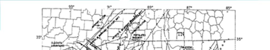
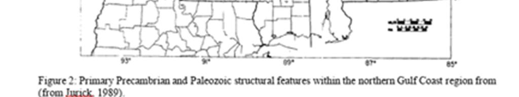
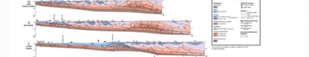
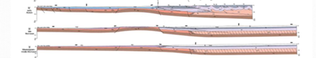
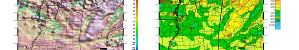
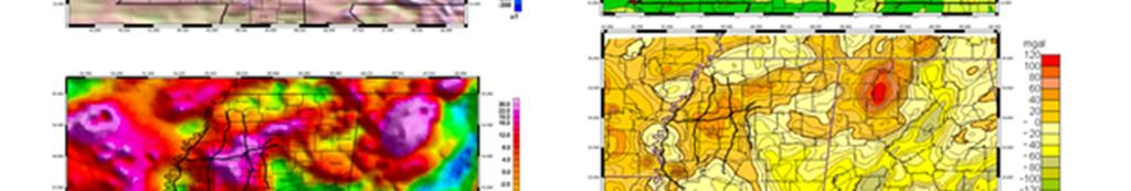
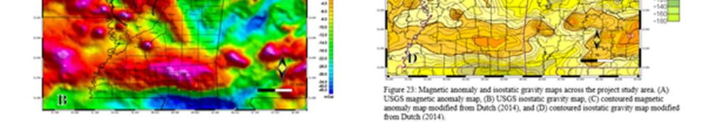
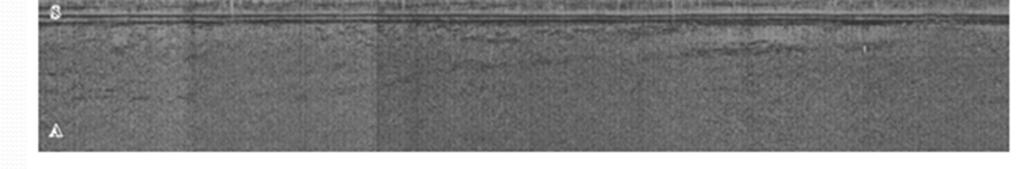
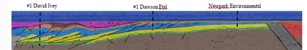
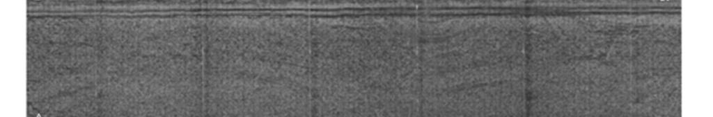
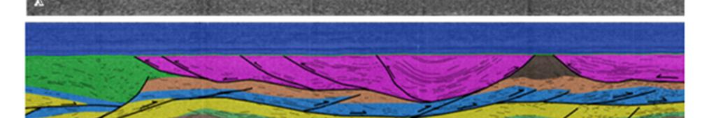
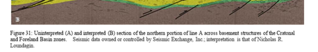
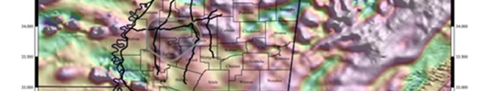
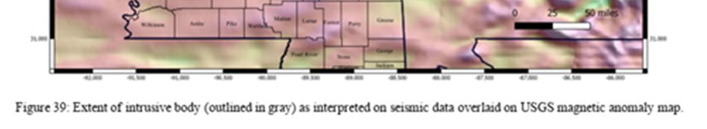
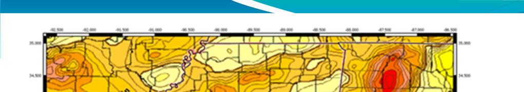
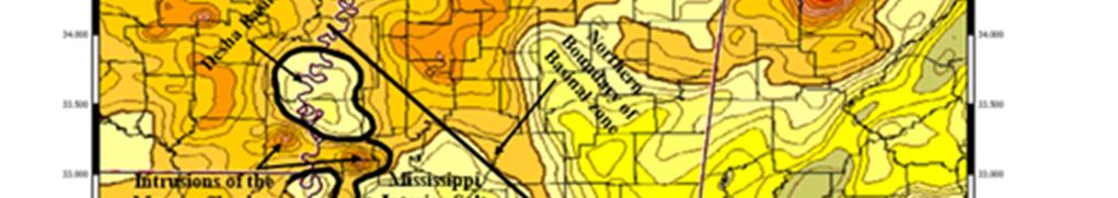
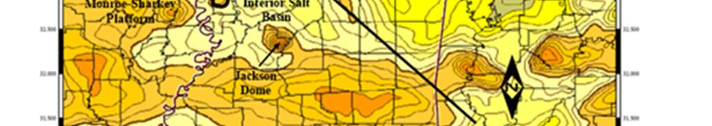
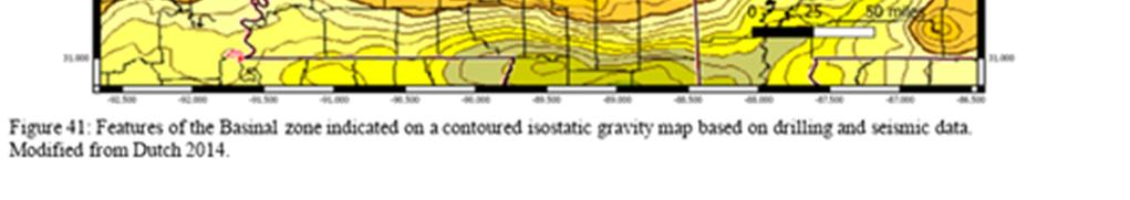
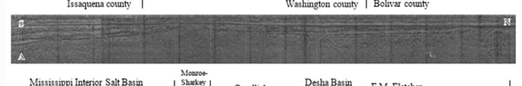
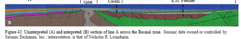
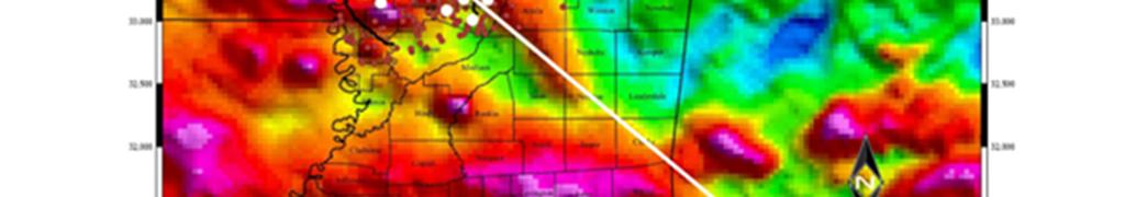
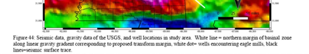
1 Structural Styles and Geotectonic Elements in Northwestern Mississippi: Interpreted from Gravity, Magnetic, and Proprietary 2D Seismic Data Nick Loundagin 1 and Gary L. Kinsland W. Euclid Pl., Littleton, Colorado School of Geosciences, University of Louisiana at Lafayette, Hamilton Hall, Rm. 323, 611 McKinley St., Lafayette, Louisiana GCAGS Explore & Discover Article #00364 * Posted September 29, * Article based on an extended abstract published in the GCAGS Transactions (see footnote reference below), which is available as part of the entire 2018 GCAGS Transactions volume via the GCAGS Bookstore at the Bureau of Economic Geology ( or as an individual document via AAPG Datapages, Inc. ( and delivered as an oral presentation at the 68th Annual GCAGS Convention and 65th Annual GCSSEPM Meeting in Shreveport, Louisiana, September 30 October 2, EXTENDED ABSTRACT The tectonic history of the southern Laurentian continental margin is characterized by a succession of two complete Wilson cycles. In northwestern Mississippi, the tectonic history and configuration of geotectonic elements associated with the development of the Gulf of Mexico Basin is poorly understood due to a lack of publicly available data and a thick succession of overlying Mesozoic sediments. To more accurately map and define tectonic elements of the region an extensive set of regional geophysical data including: gravity data, magnetic data, and a proprietary set of regional 2D seismic data (the use of which was granted by Seismic Exchange, Inc.). Using these data, and the sparse well control, we define distinct zones of varying structural styles and unique geotectonic elements within the region and provide new insight into the tectonic evolution of the northern margin of the Gulf of Mexico Basin in northwestern Mississippi. Figures 1 4 provide key illustrations. The Cratonal Zone is defined by the extent of Precambrian basement across the region and is segmented by an orthogonal set of northeast-southwest and northwestsoutheast trending faults. A large northeast-southwest trending fault identified in seismic data within the northern study area is interpreted as the southeastern bounding fault of the Reelfoot Rift. East of the Reelfoot Rift, a series of sub-rift-parallel horst and grabens have been identified. Faulting of the horst-graben sequence displaces overlying Paleozoic sediments suggesting the faults either initiated during ~Cambrian rifting and exhibited continued movement during the Paleozoic, or the faults may instead be related to later Paleozoic compressional episodes. At its southern limit, Precambrian basement material of the Cratonal Zone is dissected by a series of tightly spaced, northwest-southeast trending normal faults displacing the overlying Cambrian-Ordovician carbonate sequence. The southward continuation of the Cratonal Zone is interpreted to align with high angle, down to the south, nor- Originally published as: Loundagin, N., and G. L. Kinsland, 2018, Structural styles and geotectonic elements in northwestern Mississippi: Interpreted from gravity, magnetic, and proprietary 2D seismic data: Gulf Coast Association of Geological Societies Transactions, v. 68, p
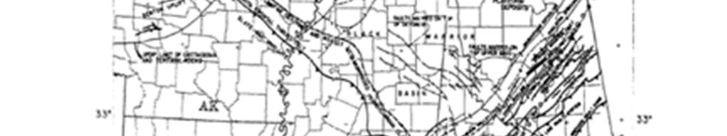
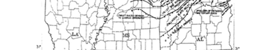
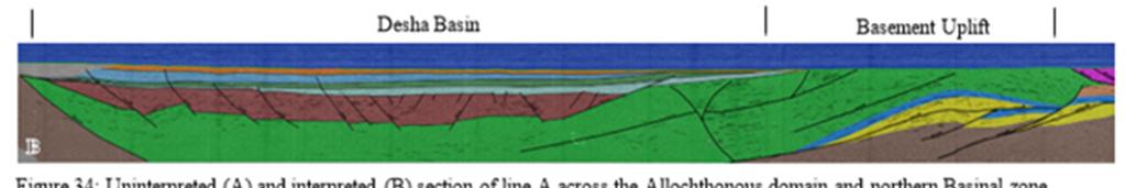
2 Loundagin and Kinsland mal faulting that abruptly truncates and displaces Precambrian basement material beneath the limit of seismic data. The timing of northwest-southeast oriented faults along the southern limit of the Cratonal Zone is unknown, but it is proposed that this faulting was likely initiated during late Precambrian Early Cambrian rifting. However, the primary growth of the faulting was associated with deposition and downwarping across the Paleozoic passive continental margin. The, now, foreland basin is composed primarily of Cambrian-Devonian shelf carbonates and Carboniferous clastics deposited on top of Precambrian material along the southern continental margin. Cambrian-Ordovician clastic and carbonate sediments that floor the Foreland Basin Zone can be traced to the southern limits of the Cratonal Zone. In the southwestern region of the Foreland Basin Zone, Paleozoic sediments extend beneath north verging frontal thrust structures of the Ouachita Orogenic Belt. Carbonate sediments of the Knox group, and younger, are interpreted to be incorporated within and deformed by foreland vergent thrusts. The basal Paleozoic sediments in the southwestern region of the Foreland Basin Zone are displaced across faults interpreted to represent inverted normal faults associated with Carboniferous compressional episodes. Middle-Upper Paleozoic sediments in the eastern limits of the study area are shown to drape across northwest-southeast trending normal faults along the southeastern end of the Cratonal Zone. Again, suggesting that northwest-southeast trending faults of the Cratonal Zone were at least pre Middle Paleozoic. Divisible into two structural domains, the frontal and allochthonous domains, elements of the Ouachita Zone are completely confined to the subsurface and are visible across western and central Mississippi. Thrust-related structures are only identifiable in seismic data of the western region of the study area. Structures of the Frontal domain in the central portion of the study area are missing due to the emplacement of Jurassic intrusions along the southern limit of the Cratonal Zone. Corresponding to the limits of the Cratonal Zone, the Frontal domain is characterized by two structural levels separating autochthonous platform and Carboniferous sediments. Extensional basement faults are interpreted to have been reactivated and inverted to form through going thrust structures displacing Paleozoic sediments correlatable across multiple seismic lines. Carboniferous strata within the upper detachment represent back thrusting of para-autochthonous sediments due to foreland vergent thrust wedging along the lower detachment. The lower detachment follows a ramp-flat type geometry stemming from the basement dislocation at the southern end of the Cratonal Zone. Southward dipping small, imbricate thrusts branching from the detachment surface displace Ordovician through Devonian platform sediments deep into the foreland. The Allochthonous domain of the Ouachita Zone is characterized by large, southward dipping imbricated thrust sheets branching from a basal detachment. In the western study area, thrust faults continue beneath the limit of seismic data, but are interpreted to sole into a basal detachment. Sediments and structures of the Allochthonous domain are absent in much of the central and eastern regions of the study area due to the presence of large, amalgamated intrusive bodies observed across multiple seismic lines. The seismically defined limit of the basinal zone corresponds to a linear gravity minima separating Mesozoic rift-related basins to the south from Precambrian and intrusive bodies to the north. Within the basinal zone, seismic and well data confirm the presence of Precambrian crystalline material, Jurassic igneous bodies, and Cretaceous uplifts and intrusions. Syn-rift Triassic clastics confined to grabens paralleling the defined limit of the Basinal Zone are interpreted as evidence for a Mesozoic rift-related transform across Mississippi separating larger rift basins of southwestern Arkansas and southeastern Alabama. 2


3 Nicholas R. Loundagin and Gary L. Kinsland University of Louisiana at Lafayette
4
5 These seismic data have an interesting history. They are 70s vintage road/vibrator/spec data. They were given to me as paper copies by Western Geophysical in the early 1980s. I tried to get students to work the data several times however, it was clearly a major project. I asked Nick a few years ago he took charge. He sought and received permission to utilize and publish the data from Seismic Exchange Incorporated (SEI). He found someone to scan the paper copies which he then incorporated into computer programs where he could interpret on the data and then overlay colors. As an indication or his dedication he has 72 references this is one of the most comprehensive collections of references for the southern continental boundary/northern Gulf of Mexico boundary that I know of. I will present only a small part of what he has interpreted and correlated to the work of others. His full thesis will soon be digitally available. I recommend reading it if the structure of the Northern Margin of the Gulf of Mexico Basin interests you.
6

7
8
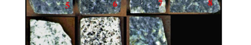
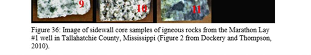
9
10

11
12

13
14
15
16
17
18


19
Osareni C. Ogiesoba and Angela K. Eluwa. Bureau of Economic Geology, University of Texas at Austin, Burnet Rd., Austin Texas 78759
 Structural Styles of Eocene Jackson and Oligocene Vicksburg Formations within the Rio Grande and Houston Embayments near the San Marcos Arch, Refugio and Calhoun Counties, South Texas Gulf Coast Osareni
Sedimentology, Petrography, and Mineralogy of the Tallahatta Formation near the City of Meridian, Mississippi
 Sedimentology, Petrography, and Mineralogy of the Tallahatta Formation near the City of Meridian, Mississippi Kiana McFadden and Ezat Heydari Department of Physics, Atmospheric Sciences, and Geoscience,
Structural Geology of the Mountains
 Structural Geology of the Mountains Clinton R. Tippett Shell Canada Limited, Calgary, Alberta clinton.tippett@shell.ca INTRODUCTION The Southern Rocky Mountains of Canada (Figure 1) are made up of several
Structural Style in the Peel Region, NWT and Yukon
 Structural Style in the Peel Region, NWT and Yukon Adriana Taborda* Husky Energy and University of Calgary, Calgary, AB Adriana.Taborda@huskyenergy.ca and Deborah Spratt University of Calgary, Calgary,
Structural Style and Tectonic Evolution of the Nakhon Basin, Gulf of Thailand
 Structural Style and Tectonic Evolution of the Nakhon Basin, Gulf of Thailand Piyaphong Chenrai Petroleum Geoscience Program, Department of Geology, Faculty of Science, Chulalongkorn University, Bangkok
The McCully gas field in southern New Brunswick was discovered in the year 2000 on a joint drilling exploration venture by Corridor Resources Inc.
 1 The McCully gas field in southern New Brunswick was discovered in the year 2000 on a joint drilling exploration venture by Corridor Resources Inc. and Potash Corporation of Saskatchewan. Located about
Earth Science, (Tarbuck/Lutgens) Chapter 10: Mountain Building
 Chapter 10: Mountain Building") Earth Science, (Tarbuck/Lutgens) Chapter 10: Mountain Building 1) A(n) fault has little or no vertical movements of the two blocks. A) stick slip B) oblique slip C) strike slip D) dip slip 2) In a(n) fault,
Earth Science, (Tarbuck/Lutgens) Chapter 10: Mountain Building 1) A(n) fault has little or no vertical movements of the two blocks. A) stick slip B) oblique slip C) strike slip D) dip slip 2) In a(n) fault,
Salt tectonic styles in the spreading basin: Yucatan, Offshore Mexico Purnima Bhowmik*, Rodolfo Hernandez and Katarina Rothe, TGS
 1 Purnima Bhowmik*, Rodolfo Hernandez and Katarina Rothe, TGS Summary The TGS Gigante project is comprised of 188,497 km of 2D seismic data acquired in 2016 and primarily covering the offshore Mexican
General Geologic Setting and Seismicity of the FHWA Project Site in the New Madrid Seismic Zone
 General Geologic Setting and Seismicity of the FHWA Project Site in the New Madrid Seismic Zone David Hoffman University of Missouri Rolla Natural Hazards Mitigation Institute Civil, Architectural & Environmental
A Structural Re-Evaluation of the Ardmore Basin*
 A Structural Re-Evaluation of the Ardmore Basin* Molly Simpson 1 Search and Discovery Article #10795 (2015)** Posted November 30, 2015 *Adapted from oral presentation given at AAPG Mid-Continent Section
Quick-Look Deterministic Approach for Evaluating Shale Distribution in Sandstone Reservoirs: Progress Report
 Quick-Look Deterministic Approach for Evaluating Shale Distribution in Sandstone Reservoirs: Progress Report James J. Willis 1,2, Duncan S. McIntosh, Jr. 3, Gregory J. Ferguson 3, Jesse W. Zwennes 3, James
Figure 1. Examples of vector displacement diagrams for two and three-plate systems.
 Figure 1. Examples of vector displacement diagrams for two and three-plate systems. Figure 2. Relationships between pole of rotation, great circles, ridge segments, small circles, transforms and fracture
Evolution of Continents Chapter 20
 Evolution of Continents Chapter 20 Does not contain complete lecture notes. Mountain belts Orogenesis the processes that collectively produce a mountain belt Includes folding, thrust faulting, metamorphism,
Structure of the western Brooks Range fold and thrust belt, Arctic Alaska
 Trabajos de Geología, Universidad de Oviedo, 29 : 218-222 (2009) Structure of the western Brooks Range fold and thrust belt, Arctic Alaska J. DE VERA 1* AND K. MCCLAY 2 1Now at: Shell, Rijswijk, Netherlands.
L.K. Carr 1, R.J. Korsch 1, A.J. Mory 2, R.M. Hocking 2, S.K. Marshall 1, R.D. Costelloe 1, J. Holzschuh 1, J.L. Maher 1. Australia.
 STRUCTURAL AND STRATIGRAPHIC ARCHITECTURE OF WESTERN AUSTRALIA S FRONTIER ONSHORE SEDIMENTARY BASINS: THE WESTERN OFFICER AND SOUTHERN CARNARVON BASINS L.K. Carr 1, R.J. Korsch 1, A.J. Mory 2, R.M. Hocking
Summary. Study Area. Data Acquisition
 Evidence for hyper-extended continental crust in the East Orphan Basin from seismic reflection data and potential field forward modelling and inversion J. Kim Welford 1, Deric Cameron 2, James Carter 2
A comparison of structural styles and prospectivity along the Atlantic margin from Senegal to Benin. Peter Conn*, Ian Deighton* & Dario Chisari*
 A comparison of structural styles and prospectivity along the Atlantic margin from Senegal to Benin Overview Peter Conn*, Ian Deighton* & Dario Chisari* * TGS, Millbank House, Surbiton, UK, KT6 6AP The
Controls on facies distributions in the Charlie Lake Formation, Peace River Arch, Alberta
 Controls on facies distributions in the Charlie Lake Formation, Peace River Arch, Alberta E.L. Percy 12, C. Frostad 2, A. Juska 2, C. Schmidt 2, C. Sitzler 2, and J.P. Zonneveld 3 University of Calgary,
MUHAMMAD S TAMANNAI, DOUGLAS WINSTONE, IAN DEIGHTON & PETER CONN, TGS Nopec Geological Products and Services, London, United Kingdom
 Geological and Geophysical Evaluation of Offshore Morondava Frontier Basin based on Satellite Gravity, Well and regional 2D Seismic Data Interpretation MUHAMMAD S TAMANNAI, DOUGLAS WINSTONE, IAN DEIGHTON
Subsurface Structural Analysis Using Well Logs to Study Faults of the Lower Atokan Formation in the Arkoma Basin, Northcentral Arkansas
 IOSR Journal of Environmental Science, Toxicology and Food Technology (IOSR-JESTFT) e-issn: 2319-2402,p- ISSN: 2319-2399.Volume 11, Issue 5 Ver. II (May. 2017), PP 65-77 www.iosrjournals.org Subsurface
Source Body Migration, an Approximate Inversion Method for Full Tensor Gravity Gradiometer Data
 Source Body Migration, an Approximate Inversion Method for Full Tensor Gravity Gradiometer Data James Brewster, Alan Morgan, and John Mims * Bell Geospace Inc., 400 N. Sam Houston Pkwy E., Ste. 325, Houston,
Global Tectonics. Kearey, Philip. Table of Contents ISBN-13: Historical perspective. 2. The interior of the Earth.
 Global Tectonics Kearey, Philip ISBN-13: 9781405107778 Table of Contents Preface. Acknowledgments. 1. Historical perspective. 1.1 Continental drift. 1.2 Sea floor spreading and the birth of plate tectonics.
Overview of the Seismic Source Characterization for the Palo Verde Nuclear Generating Station
 Overview of the Seismic Source Characterization for the Palo Verde Nuclear Generating Station Scott Lindvall SSC TI Team Lead Palo Verde SSC SSHAC Level 3 Project Tuesday, March 19, 2013 1 Questions from
New Mexico Geological Society
 New Mexico Geological Society Downloaded from: http://nmgs.nmt.edu/publications/guidebooks/35 Structural anomalies in the Espanola Basin Bruce A. Black, 1984, pp. 59-62 in: Rio Grande Rift (Northern New
Phanerozoic (last 0.54 by) Tectonics Climate Life
 Tectonics Climate Life") Phanerozoic (last 0.54 by) Tectonics Climate Life Tools for Locating Past Continent Positions Fossils depending on climate Alignment of geological features Geometrical fit of continental margins Similarity
Phanerozoic (last 0.54 by) Tectonics Climate Life Tools for Locating Past Continent Positions Fossils depending on climate Alignment of geological features Geometrical fit of continental margins Similarity
APPENDIX C GEOLOGICAL CHANCE OF SUCCESS RYDER SCOTT COMPANY PETROLEUM CONSULTANTS
 APPENDIX C GEOLOGICAL CHANCE OF SUCCESS Page 2 The Geological Chance of Success is intended to evaluate the probability that a functioning petroleum system is in place for each prospective reservoir. The
GEOL372: Week 5 Thrust fault systems. Contractional regimes
 4/3/15 GEOL372: Week 5 Thrust fault systems Contractional regimes Thrust faulting accommodates shortening σ3 σ1 1 Thrust geometry Thrust geometry RAMP segment of fault with different strike and/or dip
Overview of Selected Shale Plays in New Mexico*
 Overview of Selected Shale Plays in New Mexico* Ron Broadhead 1 Search and Discovery Article #10627 (2014)** Posted August 18, 2014 *Adapted from presentation at RMAG luncheon meeting, Denver, Colorado,
Thesis Proposal: Salt Reconstruction and Study of Depositional History, Upper Jurassic, East Texas Basin
 Thesis Proposal: Salt Reconstruction and Study of Depositional History, Upper Jurassic, East Texas Basin By: Krista Mondelli Advisor: Dr. Chris Liner April, 2009 2 Introduction The East Texas Basin covers
We A Multi-Measurement Integration Case Study from West Loppa Area in the Barents Sea
 We-16-12 A Multi-Measurement ntegration Case Study from West Loppa Area in the Barents Sea. Guerra* (WesternGeco), F. Ceci (WesternGeco), A. Lovatini (WesternGeco), F. Miotti (WesternGeco), G. Milne (WesternGeco),
Topics Laramide Orogeny: Late Cretaceous to Early Eocene Reading: GSA DNAG volume 3, Ch. 6
 Topics Laramide Orogeny: Late Cretaceous to Early Eocene Reading: GSA DNAG volume 3, Ch. 6 Late Cretaceous to early Eocene New patterns developed 5 main regions Tectonic interpretations Post-Laramide events
New Mexico Geological Society
 New Mexico Geological Society Downloaded from: http://nmgs.nmt.edu/publications/guidebooks/27 Structural framework of the southern Raton Basin, New Mexico Lee A. Woodward and D. O. Snyder, 1976, pp. 125-127
USGS: USGS: NEIC NEIC
 Triggered Earthquakes in North-Central Arkansas and their Relationship to Class II UIC Wells Scott M. Ausbrooks, The Arkansas Geological Survey Steve Horton, Ph.D., CERI at University i of Memphis Contributors:
35th Annual GCSSEPM Foundation Bob F Perkins Research Conference 2016
 35th Annual GCSSEPM Foundation Bob F Perkins Research Conference 2016 Mesozoic of the Gulf Rim and Beyond: New Progress in Science and Exploration of the Gulf of Mexico Basin Houston, Texas, USA 8 9 December
IV OTHER TYPES OF BASINS
 IV OTHER TYPES OF BASINS 1-Strike-slip basins 2-Cratonic basins 3 Late orogenic basins and more 1 Tectonic setting of strike-slip faulting Woodcock 1986 2 Seismic examples of stike-slip faults «!Flower
Facies Reconstruction of a Late Pleistocene Cypress Forest Discovered on the Northern Gulf of Mexico Continental Shelf
 Facies Reconstruction of a Late Pleistocene Cypress Forest Discovered on the Northern Gulf of Mexico Continental Shelf Suyapa Gonzalez 1, Samuel J. Bentley, Sr. 1, Kristine L. DeLong 3, Kehui Xu 2, Jeffrey
New Mexico Geological Society
 New Mexico Geological Society Downloaded from: http://nmgs.nmt.edu/publications/guidebooks/25 Structure of the Guadalupe Box area, Sandoval County, New Mexico Harvey R. DuChene, 1974, pp. 131-135 in: Ghost
Perspectives from Offshore Argentina & Uruguay
 Perspectives from Offshore Argentina & Uruguay A Prospectivity Overview Hannah Kearns October 2018 Introduction Argentina Offshore License Round 1 14 blocks Argentina North, 24 Austral-Malvinas Offshore
Hildebrand Analysis: Topic 4
 Steven Plescia 12/9/16 Hildebrand Analysis: Topic 4 Hildebrand interprets much of the classic late pc-paloezoic Cordilleran miogeocline as exotic to North America Is there a break in the detrital zircons
New Mexico Geological Society
 New Mexico Geological Society Downloaded from: http://nmgs.nmt.edu/publications/guidebooks/29 Laramide thrust faulting, Klondike Hills, southwestern New Mexico LeRoy L. Corbitt, F. L. Nials, and R. J.
TH P5 07 INSIGHTS INTO THE TECTONIC EVOLUTION AND PROSPECTIVITY OF MADAGASCAR OFFSHORE BASINSN
 Technical paper TH P5 07 INSIGHTS INTO THE TECTONIC EVOLUTION AND PROSPECTIVITY OF MADAGASCAR OFFSHORE BASINSN Authors R. Dirkx* (TGS), F. Winter (TGS), S. Musa (TGS), R. Cooke (TGS), B. Sayers (TGS),
Abstract. *Modified from extended abstract prepared for presentation at AAPG Annual Convention, Calgary, Alberta, June 19-22, 2005
 The Jurassic-Cretaceous North Sea Rift Dome and Associated Basin Evolution* By Ole Graversen 1 Search and Discovery Article #30040 (2006) Posted February 19, 2006 *Modified from extended abstract prepared
Geology 300, Physical Geology Spring 2019 Quiz Ch 19, Plate Tectonics Name
 Geology 300, Physical Geology Spring 2019 Quiz Ch 19, Plate Tectonics Name MULTIPLE CHOICE. Choose the one alternative that best completes the statement or answers the question. 1) The portion of a fracture
We C2 06 Pre-Cretaceous Structural Development of the Leirdjupet Fault Complex and its Impact on Prospectivity, Southwestern Barents Sea, Norway
 We C2 06 Pre-Cretaceous Structural Development of the Leirdjupet Fault Complex and its Impact on Prospectivity, Southwestern Barents Sea, Norway K.H. Dittmers* (DEA Norge As), I. Kjørsvik (Wintershall
Lecture 15. Fold-Thrust Belts, and the NJ Ridge and Valley Thrust System
 Lecture 15 Fold-Thrust Belts, and the NJ Ridge and Valley Thrust System Earth Structure (2 nd Edition), 2004 W.W. Norton & Co, New York Slide show by Ben van der Pluijm WW Norton; unless noted otherwise
Geologic History of Texas: The Making of Texas Over 1.5 Billion Years
 # 4 Geologic History of Texas: The Making of Texas Over 1.5 Billion Years Dr. Richard Kyle March 24, 2000 Produced by and for Hot Science - Cool Talks by the Environmental Science Institute. We request
3. The diagram below shows how scientists think some of Earth's continents were joined together in the geologic past.
 1. The map below shows the present-day locations of South America and Africa. Remains of Mesosaurus, an extinct freshwater reptile, have been found in similarly aged bedrock formed from lake sediments
Chapter 16. Mountain Building. Mountain Building. Mountains and Plate Tectonics. what s the connection?
 Chapter 16 Mountains and Plate Tectonics what s the connection? Mountain Building Most crustal deformation occurs along plate margins. S.2 Active Margin Passive Margin Mountain Building Factors Affecting
Unconformities are depositional contacts that overlie rocks distinctly older than they are. They are often called gaps in the sedimentary record.
 UNCONFORMITIES Unconformities are depositional contacts that overlie rocks distinctly older than they are. They are often called gaps in the sedimentary record. The contact represents time when no sediment
SEG/San Antonio 2007 Annual Meeting
 ; Application to Forth Worth Basin Suat Aktepe, Kurt J. Marfurt, Center for Applied Geosciences and Energy, Dept. of Geosciences, University of Houston Summary By definition, the focus of seismic exploration
GPR AS A COST EFFECTIVE BEDROCK MAPPING TOOL FOR LARGE AREAS. Abstract
 GPR AS A COST EFFECTIVE BEDROCK MAPPING TOOL FOR LARGE AREAS Dr. Jutta L. Hager, Hager GeoScience, Inc., Waltham, MA Mario Carnevale, Hager GeoScience, Inc., Waltham, MA Abstract Hager GeoScience, Inc.
Mountains and Mountain Building: Chapter 11
 Mountains and Mountain Building: Chapter 11 Objectives: 1)Explain how some of Earth s major mountain belts formed 2) Compare and contrast active and passive continental margins 3) Explain how compression,
Palinspastic restoration of the Anniston transverse zone in the Appalachian thrust belt, Alabama
 Journal of Structural Geology 2 2002) 797±826 www.elsevier.com/locate/jstrugeo Palinspastic restoration of the Anniston transverse zone in the Appalachian thrust belt, Alabama William A. Thomas*, GermaÂn
Heat Flow in the Caspian Black Sea Region and its Tectonic Implications*
 Heat Flow in the Caspian Black Sea Region and its Tectonic Implications* R. I. Kutas 1 Search and Discovery Article #50400 (2011) Posted April 25, 2011 *Adapted from extended abstract prepared for presentation
Geologic Structures. Changes in the shape and/or orientation of rocks in response to applied stress
 Geologic Structures Changes in the shape and/or orientation of rocks in response to applied stress Figure 15.19 Can be as big as a breadbox Or much bigger than a breadbox Three basic types Fractures >>>
The Late Tertiary Deep-Water Siliciclastic System of the Levant Margin - An Emerging Play Offshore Israel*
 The Late Tertiary Deep-Water Siliciclastic System of the Levant Margin - An Emerging Play Offshore Israel* Michael A. Gardosh 1, Yehezkel Druckman 2 and Binyamin Buchbinder 2 Search and Discovery Article
SEDIMENTARY BASINS BASIN TYPES ACCORDING TO TECTONIC. by Prof. Dr. Abbas Mansour
 SEDIMENTARY BASINS BASIN TYPES ACCORDING TO TECTONIC by Prof. Dr. Abbas Mansour B. Convergent plate margins 10. STABLE CONTINENTAL INTERIOR BASIN E.g. Lake Eyre Basin Intracratonic (= within stable continental
SEG Houston 2009 International Exposition and Annual Meeting
 Salt interpretation validated by salt tectonic study in the offshore Gulf of Mexico Li Li *, Itze Chang and Quincy Zhang, TGS-NOPEC Geophysical Company Summary To identify and define a complex salt body
Strike-Slip Faults. ! Fault motion is parallel to the strike of the fault.
 Strike-Slip Faults! Fault motion is parallel to the strike of the fault.! Usually vertical, no hanging-wall/footwall blocks.! Classified by the relative sense of motion. " Right lateral opposite block
Physiographic Provinces (West, Ch. 13)
") Geology 229 Engineering Geology Lecture 13 Physiographic Provinces (West, Ch. 13) The definition of the term Physiography Physiography (n.) The science which treats of the earth's exterior physical features,
Geology 229 Engineering Geology Lecture 13 Physiographic Provinces (West, Ch. 13) The definition of the term Physiography Physiography (n.) The science which treats of the earth's exterior physical features,
Search and Discovery Article #40536 (2010) Posted June 21, 2010
 Posted June 21, 2010") Modern Examples of Mass Transport Complexes, Debrite and Turbidite Associations: Geometry, Stratigraphic Relationships and Implications for Hydrocarbon Trap Development* Fabiano Gamberi 1, Marzia Rovere
Modern Examples of Mass Transport Complexes, Debrite and Turbidite Associations: Geometry, Stratigraphic Relationships and Implications for Hydrocarbon Trap Development* Fabiano Gamberi 1, Marzia Rovere
Kilometre-Scale Uplift of the Early Cretaceous Rift Section, Camamu Basin, Offshore North-East Brazil*
 Kilometre-Scale Uplift of the Early Cretaceous Rift Section, Camamu Basin, Offshore North-East Brazil* Iain Scotchman 1 and Dario Chiossi 2 Search and Discovery Article #50183 (2009) Posted May 20, 2009
Modern geodynamic model of the Arctic Ocean
 Modern geodynamic model of the Arctic Ocean O. Petrov, N. Sobolev, A. Morozov, G. Grikurov, S. Shokalsky, S. Kashubin, E. Petrov Vienna, April 2012 Atlas of Geological Maps of the Circumpolar Arctic Magnetic
New Kinematic Analysis of Late Pleistocene Faulting in the Blackfoot Rift Zone, Idaho
 New Kinematic Analysis of Late Pleistocene Faulting in the Blackfoot Rift Zone, Idaho Sean G. Polun David W. Rodgers Michael McCurry Idaho State University Cenozoic Extension in Southeast Idaho Modified
Controls on clastic systems in the Angoche basin, Mozambique: tectonics, contourites and petroleum systems
 P2-2-13 Controls on clastic systems in the Angoche basin, Mozambique: tectonics, contourites and petroleum systems Eva Hollebeek, Olivia Osicki, Duplo Kornpihl Schlumberger, London, UK Introduction Offshore
Geology of the Batemans Bay region. Geological evolution. The Lachlan Orogen
 Australian Journal of Earth Sciences 1 The word orogen is derived from the ancient Greek language word for mountain building. The Lachlan Orogen The rocks exposed in the Batemans Bay are part of the geological
The Late Quaternary Rio Grande Delta A Distinctive, Underappreciated Geologic System
 The Late Quaternary Rio Grande Delta A Distinctive, Underappreciated Geologic System Thomas E. Ewing 1 and Juan L. Gonzalez 2 1 Frontera Exploration Consultants, 19240 Redland Rd., Ste. 250, San Antonio,
GEOLOGY GL1 Foundation Unit
 Candidate Name Centre Number Candidate Number 2 General Certificate of Education Advanced Subsidiary/Advanced 451/01 GEOLOGY GL1 Foundation Unit P.M. THURSDAY, 10 January 2008 (1 hour) Examiner Question
The Building of the NYC Region
 The Building of the NYC Region Definitions Fall Line marks the area where an upland region (continental bedrock) and a coastal plain meet Piedmont the plateau region of the eastern United States which
Implications of new long-offset seismic lines on the Norwegian Continental Shelf
 Implications of new long-offset seismic lines on the Norwegian Continental Shelf L. Gernigon Continental Shelf Geophysics, Geological Survey of Norway (NGU) Force seminar GWL/NGU BASMARGE Project Stavanger,
Copyright McGraw-Hill Education. All rights reserved. No reproduction or distribution without the prior written consent of McGraw-Hill Education
 Copyright McGraw-Hill Education. All rights reserved. No reproduction or distribution without the prior written consent of McGraw-Hill Education Tibetan Plateau and Himalaya -southern Asia 11.00.a VE 10X
entered a rapid development phase. Annual increased proven reserves are above 500 billion cubic meters (bcm) from 2003, and annual natural gas product
 from 2003, and annual natural gas product") (), entered a rapid development phase. Annual increased proven reserves are above 500 billion cubic meters (bcm) from 2003, and annual natural gas production has increased from 50bcm in 2000 to nearly
(), entered a rapid development phase. Annual increased proven reserves are above 500 billion cubic meters (bcm) from 2003, and annual natural gas production has increased from 50bcm in 2000 to nearly
Geological Evolution of Bago-Yoma Basin, Onshore Myanmar*
 Geological Evolution of Bago-Yoma Basin, Onshore Myanmar* Seehapol Utitsan 1, Teekayu Benjawan 1, Suppakarn Thanatit 1, Wirote Wetmongkongorn 1, U. Soe Than 2, Khun Hline Myint 1, and Ler Bwe Wah 1 Search
Geology 15 West Valley College. Exam IV: Sierra Nevada
 Geology 15 West Valley College Name Exam IV: Sierra Nevada 1) On the diagram above, where is the Arc- Trench Gap? a. 1 and 3 c. 7 and 8 d. 6 e. 5 and 10 2) On the diagram above, where is the subduction
3/5/05 Dr. Stewart 1
 I. Physiography of Appalachian Mountains A. Introduction 1. These mountains extend from NE Canada to Georgia 2. They are the remains of a deeply eroded, ancient mountain chain once larger than the Himalayans
Bureau of Mineral Resources, Geology & Geophysics
 BMR PUBLICATIONS COMPACTUS (LENDlJ."IG SECTION) Bureau of Mineral Resources, Geology & Geophysics,. BMR RECORD 1990/55.. ~,- ~;),'>-, BMR RECORD 1990/55 VULCAN GRABEN, TIMOR SEA: REGIONAL STRUCTURE FROM
Seismic-Data Interpretations near the Blan Carbon Sequestration Test Well in Hancock Co., Kentucky
 Seismic-Data Interpretations near the Blan Carbon Sequestration Test Well in Hancock Co., Kentucky KYCCS Western Kentucky Deep Test Review Meeting Friday, October 23, 2009 James A. Drahovzal Consulting
The Mesozoic. Wednesday, November 30, 11
 The Mesozoic Periods of the Mesozoic Triassic- First period of the Mesozoic era Jurassic Cretaceous- Last period of the Mesozoic era Breakup of Pangaea Stage one (Triassic) Rifting and volcanism, normal
Characterizing Seal Bypass Systems at the Rock Springs Uplift, Southwest Wyoming, Using Seismic Attribute Analysis*
 Characterizing Seal Bypass Systems at the Rock Springs Uplift, Southwest Wyoming, Using Seismic Attribute Analysis* Yuri Ganshin 1 and Fred McLaughlin 1 Search and Discovery Article #80483 (2015)** Posted
Hydrocarbon Pools Of The Southeastern Great Slave Plain, Northwest Territories
 Hydrocarbon Pools Of The Southeastern Great Slave Plain, Northwest Territories Introduction E.P. Janicki* C.S. Lord Northern Geoscience Centre, Yellowknife, NWT ed_janicki@gov.nt.ca The geology of hydrocarbon
GEOLOGY - GL4 INTERPRETING THE GEOLOGICAL RECORD
 Candidate Name Centre Number 2 Candidate Number GCE A level 1214/01 GEOLOGY - GL4 INTERPRETING THE GEOLOGICAL RECORD A.M. MONDAY, 21 June 2010 2 hours Section A 1. 2. 3. 15 15 15 1214 01 01 4. 15 Section
USU 1360 TECTONICS / PROCESSES
 USU 1360 TECTONICS / PROCESSES Observe the world map and each enlargement Pacific Northwest Tibet South America Japan 03.00.a1 South Atlantic Arabian Peninsula Observe features near the Pacific Northwest
Nemaha Strike-Slip Fault Expression on 3-D Seismic Data in SCOOP Trend
 Nemaha Strike-Slip Fault Expression on 3-D Seismic Data in SCOOP Trend June 2018 Satinder Chopra, Kurt Marfurt, Folarin Kolawole, Brett M. Carpenter Fthe meaningful recognition of the faults within the
Re-Evaluation Of The Extent And Tectonic History Of The Helena Banks Fault Zone, Offshore South Carolina
 University of South Carolina Scholar Commons Theses and Dissertations 2018 Re-Evaluation Of The Extent And Tectonic History Of The Helena Banks Fault Zone, Offshore South Carolina Ahmet Postaagasi University
Paleozoic to present-day kinematic evolution of the frontal part of the Andes between parallels 23º and 24º S (Jujuy province, Argentina)
") Trabajos de Geología, Universidad de Oviedo, 30 : 214-220 (2010) Paleozoic to present-day kinematic evolution of the frontal part of the Andes between parallels 23º and 24º S (Jujuy province, Argentina)
Trabajos de Geología, Universidad de Oviedo, 30 : 214-220 (2010) Paleozoic to present-day kinematic evolution of the frontal part of the Andes between parallels 23º and 24º S (Jujuy province, Argentina)
DEFORMATION AND METAMORPHISM OF THE AILEU FORMATION, EAST TIMOR. R. F. Berry (B.Sc. Hons.) SCHOOL OF EARTH SCIENCES. May 1979
 SCHOOL OF EARTH SCIENCES. May 1979") DEFORMATION AND METAMORPHISM OF THE AILEU FORMATION, EAST TIMOR. by R. F. Berry (B.Sc. Hons.) SCHOOL OF EARTH SCIENCES FLINDERS UNIVERSITY OF SOUTH AUSTRALIA May 1979 i TABLE OF CONTENTS page Table of
DEFORMATION AND METAMORPHISM OF THE AILEU FORMATION, EAST TIMOR. by R. F. Berry (B.Sc. Hons.) SCHOOL OF EARTH SCIENCES FLINDERS UNIVERSITY OF SOUTH AUSTRALIA May 1979 i TABLE OF CONTENTS page Table of
Continental Landscapes
 Continental Landscapes Landscape influenced by tectonics, climate & differential weathering Most landforms developed within the last 2 million years System moves toward an equilibrium Continental Landscapes
Earth Science Lesson Plan Quarter 3, Week 7, Day 1
 Earth Science Lesson Plan Quarter 3, Week 7, Day 1 Outcomes for Today Standard Focus: PREPARE 1. Background knowledge necessary for today s reading. Continental ice sheets increase the weight of the Earth
Description of faults
 GLG310 Structural Geology Description of faults Horizontal stretch Crustal thickness Regional elevation Regional character Issues Normal Thrust/reverse Strike-slip >1 1 in one direction and < 1 in
Request For Bids Parcels
 Section 2 Page 14 This section provides a detailed description of each landsale parcel. Maps provided show the location of the land parcels and the released seismic data on those parcels. Hard copies and
Orphan Basin, Offshore Newfoundland: New seismic data and hydrocarbon plays for a dormant Frontier Basin
 Orphan Basin, Offshore Newfoundland: New seismic data and hydrocarbon plays for a dormant Frontier Basin Jerry Smee* G&G Exploration Consulting, 301 400-3rd Avenue SW, Calgary, AB, T2P 4H2 Sam Nader, Paul
GEOLOGIC MAPS PART II
 EARTH AND ENVIRONMENT THROUGH TIME LABORATORY - EES 1005 LABORATORY FIVE GEOLOGIC MAPS PART II Introduction Geologic maps of orogenic belts are much more complex than maps of the stable interior. Just
THERMAL MATURITY ASSESSMENT OF MIDDLE ROCKS AND HEAT FLOW MODELING IN AGATOVO-SUHINDOL AREA (CENTRAL NORTH BULGARIA)
") DOI: http://dx.doi.org/10.18509/agb.2015.01 UDC: 551.761:550.832.6.05(497.2) COBISS: THERMAL MATURITY ASSESSMENT OF MIDDLE TRIASSIC ROCKS AND HEAT FLOW MODELING IN AGATOVO-SUHINDOL AREA (CENTRAL NORTH
DOI: http://dx.doi.org/10.18509/agb.2015.01 UDC: 551.761:550.832.6.05(497.2) COBISS: THERMAL MATURITY ASSESSMENT OF MIDDLE TRIASSIC ROCKS AND HEAT FLOW MODELING IN AGATOVO-SUHINDOL AREA (CENTRAL NORTH
EDIMENTARY BASINS. What is a Sedimentary Basin? by Prof. Dr. Abbas Mansour
 EDIMENTARY BASINS What is a Sedimentary Basin? by Prof. Dr. Abbas Mansour WHAT IS A SEDIMENTARY BASIN? A low area on the Earth s surface relative to surroundings e.g. deep ocean basin (5-10 km deep) e.g.
SAND DISTRIBUTION AND RESERVOIR CHARACTERISTICS NORTH JAMJUREE FIELD, PATTANI BASIN, GULF OF THAILAND
 SAND DISTRIBUTION AND RESERVOIR CHARACTERISTICS NORTH JAMJUREE FIELD, PATTANI BASIN, GULF OF THAILAND Benjawan KIinkaew Petroleum Geoscience Program, Department of Geology, Faculty of Science, Chulalongkorn
KEY CHAPTER 12 TAKE-HOME QUIZ INTERNAL STRUCTURES AND PROCESSES Score Part B = / 55 PART B
 GEOLOGY 12 KEY CHAPTER 12 TAKE-HOME QUIZ INTERNAL STRUCTURES AND PROCESSES Score Part B = / 55 PART B CHAPTER 12 Isostacy and Structural Geology 1. Using the terms below, label the following diagrams and
Airborne gravity gradiometer surveying of petroleum systems under Lake Tanganyika, Tanzania
 Airborne gravity gradiometer surveying of petroleum systems under Lake Tanganyika, Tanzania D. Roberts Beach Energy P. Roy Chowdhury CGG S. J. Lowe CGG A. N. Christensen CGG Outline Introduction Geology
11.1 Rock Deformation
 Tarbuck Lutgens Mountain Building 11.1 Rock Deformation Factors Affecting Deformation Factors that influence the strength of a rock and how it will deform include temperature, confining pressure, rock
Carboniferous Stoddart Group: An integrated approach
 Carboniferous Stoddart Group: An integrated approach Abu Yousuf*, Department of Geoscience, University of Calgary, Calgary, Alberta yousufabu@hotmail.com and Charles M. Henderson, Department of Geoscience,
Parts of the Sevier/ Laramide Orogeny
 Parts of the Sevier/ Laramide Orogeny AA. Accretionary Prism BB. Forearc Basin Sediment scraped off of subducting plate Sediment derived from the volcanic arc CC. Volcanic Arc Magmatic intrusion into the