Cenozoic Extensional Basin Development and Sedimentation in SW Montana
|
|
|
- Tamsin Dixon
- 6 years ago
- Views:
Transcription
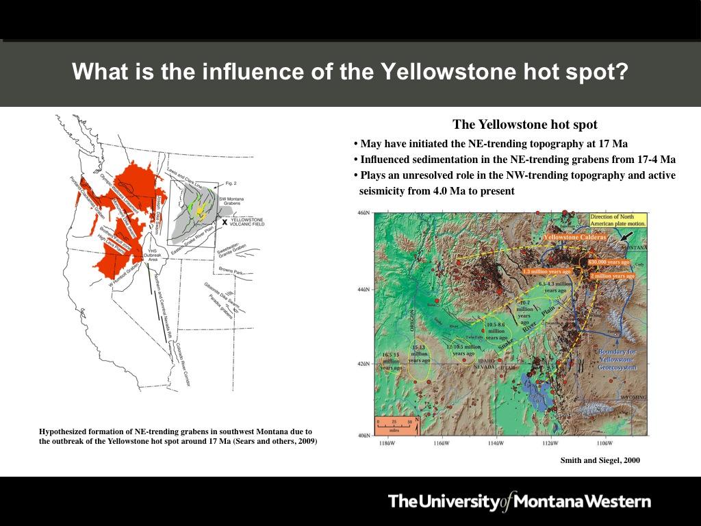
1 Cenozoic Extensional Basin Development and Sedimentation in SW Montana Robert C. Thomas Department of Environmental Sciences, The University of Montana Western, Dillon, MT 59725, (406) , Abstract Cenozoic extensional basin development in southwest Montana consists of a minimum of three primary phases of extension. Phase 1 (48-20 Ma) was a time of active extensional basin development and terrestrial deposition in a 100-km wide, north-trending rift zone in western Montana (Janecke, 2007). The rift zone is interpreted to have developed from the gravitational collapse of compressional structures formed during Cretaceous and Paleogene time. To the east of the rift was a tectonically tranquil, supradetachment basin (i.e., Renova Basin) that contained remnant topography formed during Cretaceous to early Paleogene compression and volcanism. Areas of sediment transport from the rift to the supradetachment basin are shown by provenance data gathered from fluvial deposits in the Renova Formation. Phase 2 (17-4 Ma) extension was a period of NE-trending basin development and fluvial and debris flow deposition. The initiation of extension coincides temporally with the outbreak of the Yellowstone volcano, and has been interpreted as having formed by thermal doming and radial extension around the outbreak point (Sears et al., 2009). This event preserved the Renova Basin deposits in southeast-tilted half-grabens, which are now in angular discordance with the overlying fluvial and debris-flow deposits of the Sixmile Creek Formation. Provenance studies show that streams flowed to the northeast off of the Yellowstone thermal bulges, and that the gradient increased over time as the thermal bulge progressed to the northeast (Landon & Thomas, 1999). Distinctive duriclast gravels were derived from primary sources in central Idaho and/or reworked from the Late Cretaceous Beaverhead conglomerate. The NE-trending structures were terminated around 4.0 Ma as Phase 3 (4.0 Ma-present) northwest-trending extensional topography developed in association with crustal adjustments along the northern margin of the Yellowstone volcano. Most of the current seismicity occurs on the NW-trending faults, as shown by a 5.6 magnitude earthquake that occurred on July 25th, 2005 north of Dillon, Montana. Future work includes provenance studies of the Sixmile Creek gravels and tephras to determine if crustal bulging and collapse related to the passage of the Yellowstone volcano influenced the sediment sources available to the NE-trending grabens in southwest Montana.
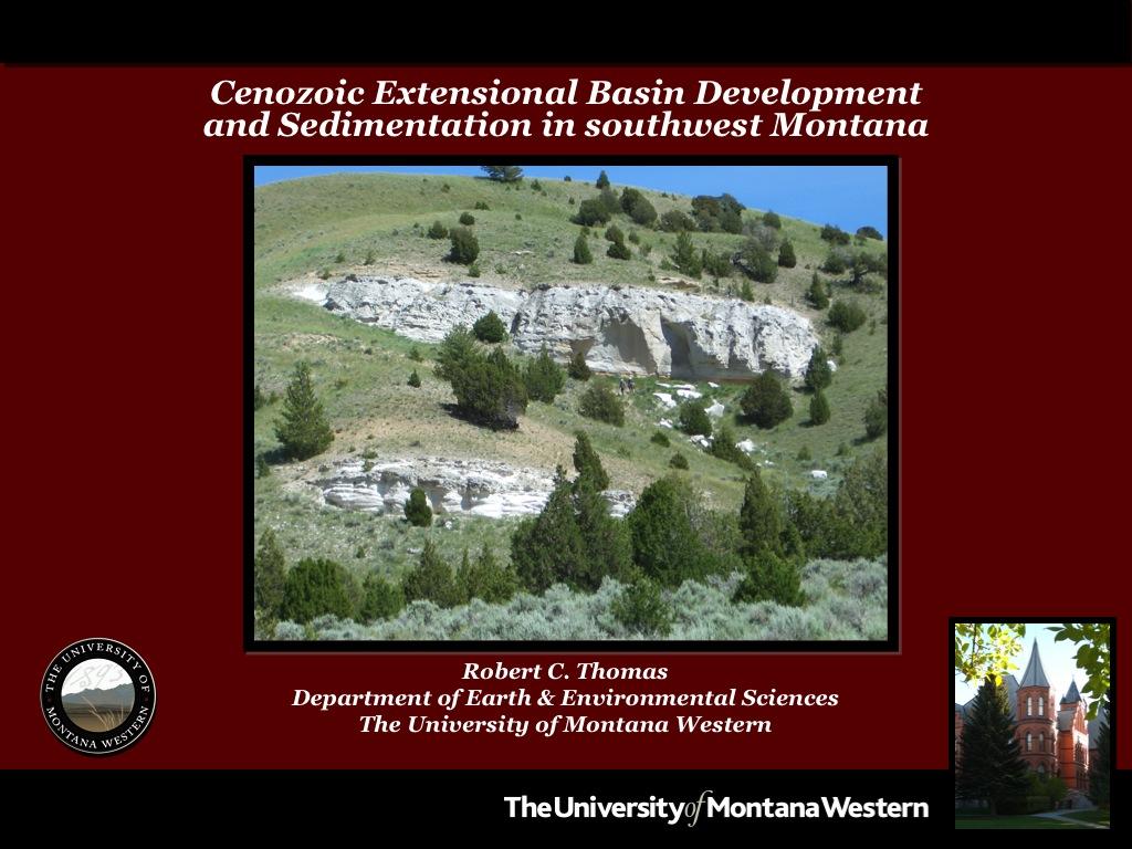
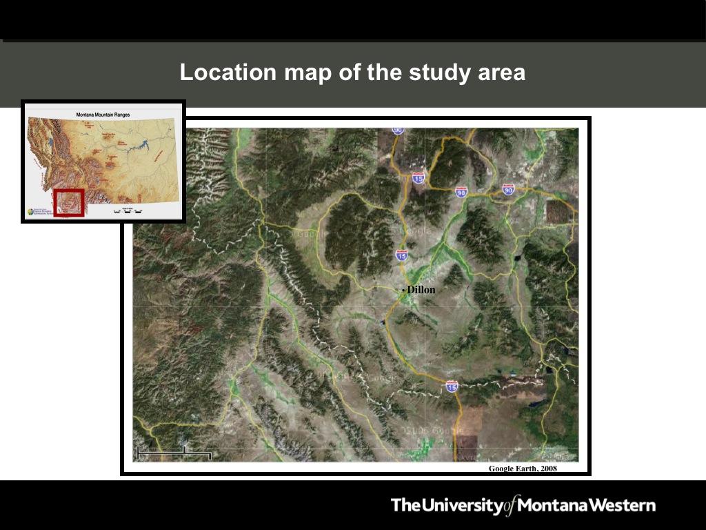
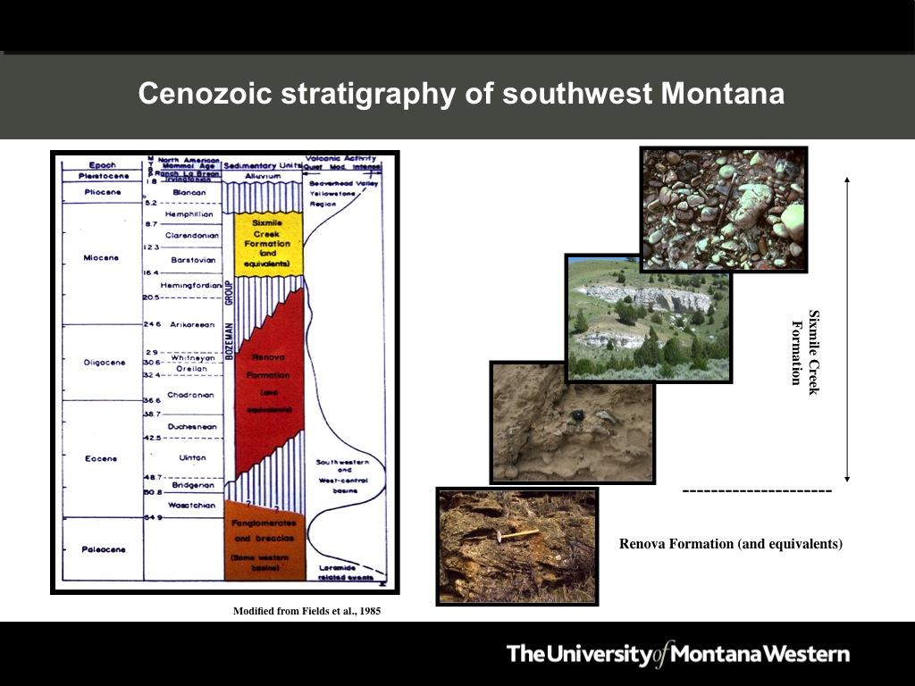
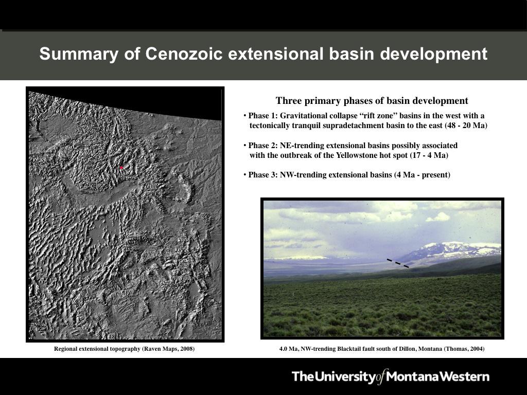
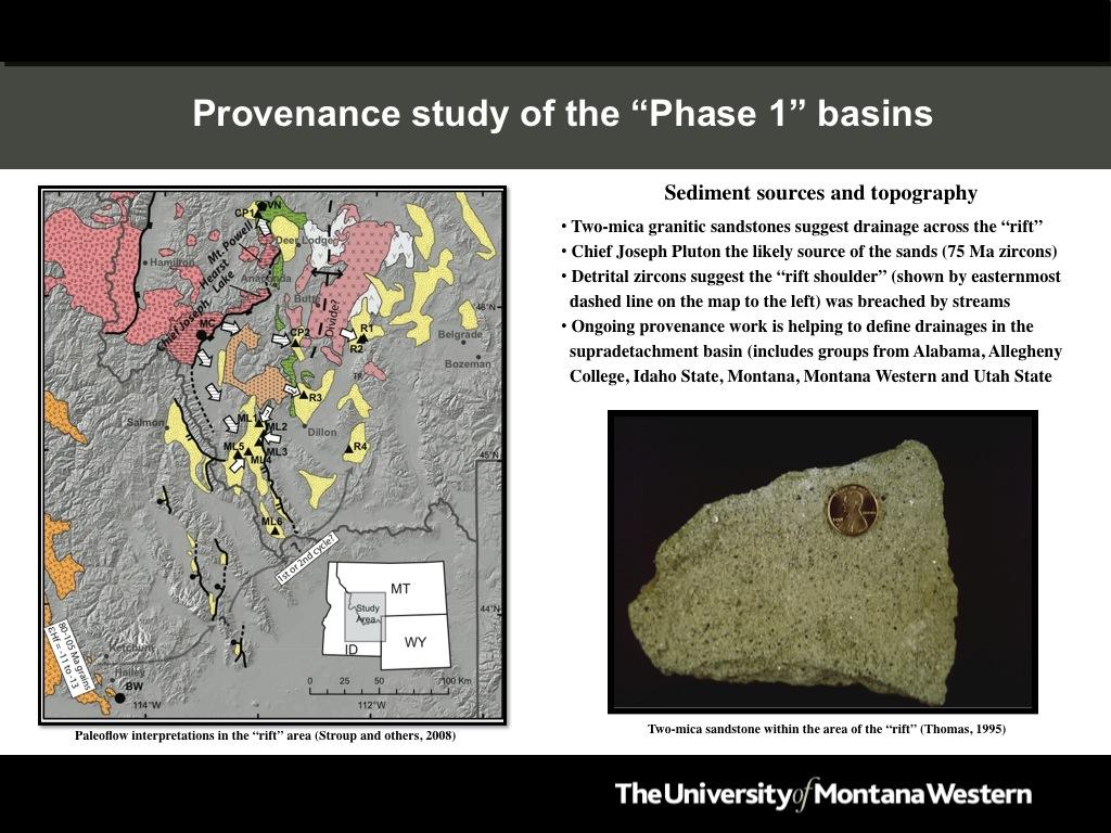
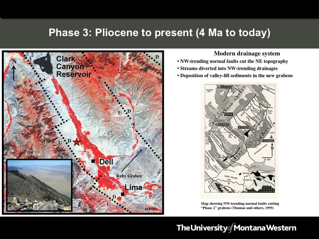
2 Slide 1: The center photo shows multiple tephras in the Sixmile Creek Formation at Timber Hill, southeast of Dillon, Montana. Slide 2: A satellite photo showing the approximate location of the study area. Northwesttrending extensional topography is obvious, and if you look carefully, you can also see an older, northeast-trending extensional topography, especially to the east of Dillon, Montana. Slide 3: The Cenozoic stratigraphy of southwest Montana. The photos to the right of the column display the typical lithologies found in these formations, including the three members of the Sixmile Creek Formation (from the base: Sweetwater, Anderson Ranch and Big Hole Gravel Members). Slide 4: A summary of the three primary phases of Cenozoic basin development in southwest Montana. Phase 1 (48-20 Ma) was a time of active extensional basin development (i.e., rift zone ) and sedimentation in western Montana. To the east of this rift zone, a tectonically tranquil, supradetachment basin developed with minimal remnant topography from Cretaceous compression and early Cenozoic volcanism. The Renova Formation and its equivalents were deposited in both the rift zone and the supradetachment basin at this time. It has been argued that the gravitational collapse of older compressional structures caused the extension. Phase 2 (17-4 Ma) was a period of NE-trending extensional basin development and fluvial/debris flow deposition. The initiation of extension coincides temporally with the outbreak of the Yellowstone volcano. The Sixmile Creek Formation was mostly deposited by northeast-flowing fluvial systems that transported gravel and tephra derived from source areas to the southwest, possible as far away as central Idaho. Phase 3 (4 Ma-present) was a period of NW-trending extensional basin development that terminated most of the NE-trending fluvial systems and diverted them into NW-trending grabens. These faults are currently active and produced a magnitude 5.6 earthquake north of Dillon on July 25, The photo in the lower right corner shows the NW-trending, Blacktail Fault south of Dillon, Montana. Slide 5: A paleogeographic map of Phase 1 (48-20 Ma) extension in southwest Montana. The map shows the location of the Paleogene rift zone and the adjacent supradetachment basin (locally called the Renova Basin ). The topography shown within the supradetachment basin is remnant topography from Mesozoic and early Cenozoic compression and volcanism. The photo to the right shows the Anaconda detachment fault and metamorphic core complex within the rift zone. This fault was active early in this phase of extension and the basin fill sediments record the unroofing history of the core complex. Slide 6: A paleoflow map of drainages within the Paleogene rift zone as determined by provenance work, including detrital zircon analyses. The data suggest that a primary
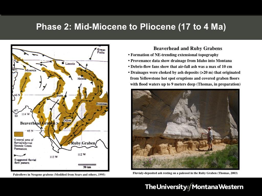
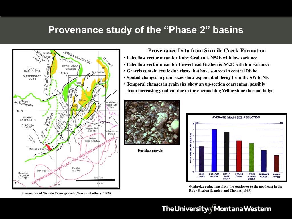
3 source of distinctive two-mica sandstones (photo on the right) was the Chief Joseph Pluton to the west, and that some streams may have breached the rift shoulder and deposited these sediments in the supradetachment basin. On-going work is helping to further refine our understanding of the provenance of the Renova Formation and its equivalents. Slide 7: A paleogeographic map of Phase 2 (17-4 Ma) extension in southwest Montana. The map shows the location of the Neogene grabens and the paleoflows of the fluvial systems based on extensive provenance work in the Sixmile Creek Formation. The photo to the right shows one of many fluvially deposited tephras in the Sixmile Creek Formation. These tephras were derived from the eruption of the Yellowstone volcano, and were deposited by floodwaters that covered much of the floodplain as shown by their occurrence on paleosols (as shown in the photo to the right). Based on measurements of the cross bedding in these tephras, the floodwaters were up to 9.0 meters deep and repeatedly flooded the basins. Ash found on debris-flow fan deposits in the Sixmile Creek Formation indicates that the thickness of air-fall ash in the area did not exceed 10 cm. Slide 8: A paleoflow map of the NE-trending drainages, and some of the mountain ranges that currently exist within the path of these paleodrainages. Duriclast gravels (center photo) in the Sixmile Creek Formation contain distinctive black chert cobbles (Milligen chert) that suggest that the headwaters of these streams were in central Idaho. Extensive provenance work shows that these streams flowed to the northeast and were relatively linear (i.e., low variance around the paleoflow vector mean). Grain-size reductions show a downstream reduction in grain size (graph on the right), and temporal changes in grain size show an up-section increase in size, possibly reflecting an increased gradient due to the encroaching Yellowstone thermal bulge over time. Slide 9: An alternative model for the origin of the sediment in the Sixmile Creek Formation. Detrital zircon work by Stroup and others (2008) has been interpreted as showing that the gravels were derived from the rift shoulder rather than central Idaho, as suggested by Sears and others (2009). According to Stroup and others (2008), the Cretaceous Beaverhead Conglomerate (photo on the right), which was possibly exposed along the rift shoulder, was the primary source of the gravels. Sears and others (2009) acknowledge that some of the gravels in the Sixmile Creek Formation were likely derived through the reworking of the Beaverhead Conglomerate, but also believe that the headwaters of these streams extended further to the south into central Idaho. Slide 10: A satellite photo showing the Phase 3 (4 Ma-present) NW-trending faults cutting the NE-trending Ruby Graben. The dark rock under the arrow in the Ruby Graben is a 6.0 Ma basalt flow called the Timber Hill Basalt that came from the Heise Volcanic Field in Idaho. The inset photo shows the modern extensional topography with an impressive amount of relief formed in the last 4.0 million years! The map to the right shows some of the other NW-trending faults that cut the Phase 2, NE-trending Beaverhead and Ruby Grabens.
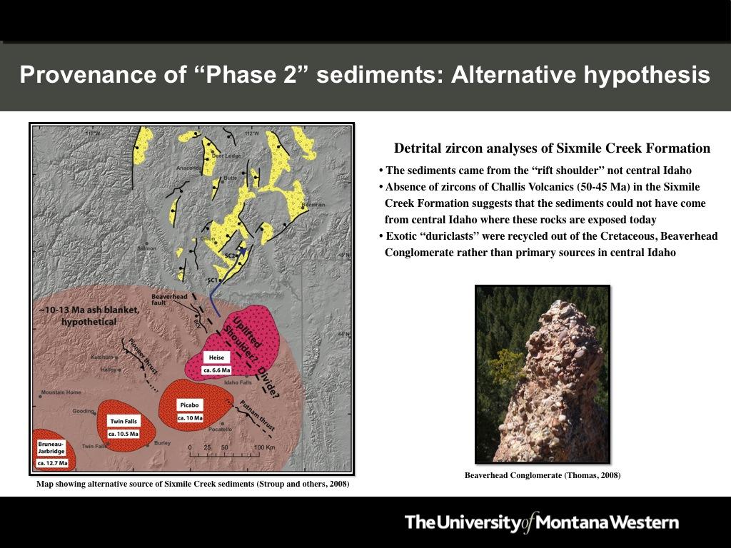
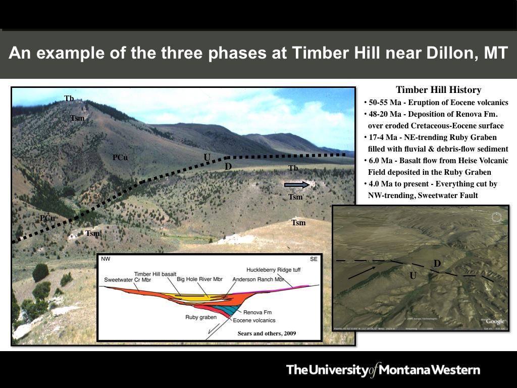
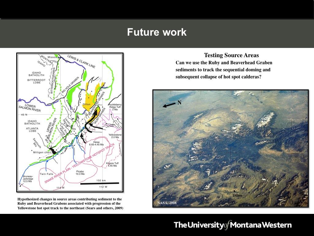
4 Slide 11: Field relationships between the three phases of basin formation at Timber Hill, southeast of Dillon, Montana. The photo on the left shows the Sixmile Creek Formation resting on Archean metamorphic rocks, and capped by the 6.0 Ma Timber Hill Basalt. The Sweetwater Fault, a NW-trending, listric normal fault, cuts the sequence and offsets the basalt by about 700 feet. The Renova Formation is not visible at this locale, because it has been removed by pre-sixmile Creek Formation erosion, but it occurs elsewhere in the area in angular discordance with the overlying Sixmile Creek Formation. The photo to the right shows an aerial view of the Sweetwater Fault and the mesas formed by the Timber Hill Basalt. Slide 12: The NW-trending Frying Pan Fault (dashed line), which produced a 5.6 magnitude earthquake on July 25 th, It ruptured at 3.0 miles depth, and the epicenter (red circle) was located 9 miles north of Dillon, Montana. The damage in Dillon was relatively minor, although numerous chimneys were damaged (photo on the right) and some historical buildings suffered minor structural damage. This fault is uplifting and tilting the Pioneer Mountains (the topography to the left in the photo) to the southwest, while it is asymmetrically dropping the divide basin (the valley to the right of the Pioneer Mountains) down to the southwest. This is the typical geometry of the NW-trending normal faults in the region. Slide 13: A hypothesized relationship between the outbreak of the Yellowstone volcano and the formation of the NE-trending extensional topography in southwest Montana around 17 Ma. The map shows other extensional features that are oriented around the outbreak point of the Yellowstone volcano around 17 Ma. There is no doubt that the track of the Yellowstone volcano affected sedimentation in the NE-trending grabens in southwest Montana, and it possibly played a role in the formation of the NW-trending topography at 4.0 Ma. Slide 14: A map that shows the potential for future work testing the influence of the passage of the Yellowstone volcano on the source areas for sediment deposited in the Beaverhead and Ruby Grabens from 17 to 4 Ma. As the Yellowstone thermal bulge progressed from the southwest to the northeast, it is possible that old sediment sources were cut off while new ones were created. Detailed provenance work should be able to work this out, and possibly test the merits of the alternative hypothesis proposed by Stroup and others (2008), shown in Slide 9.
5
6
7
8
9
10
11
12
13
14
15

16
17
18
19
20
21
Continental Landscapes
 Continental Landscapes Landscape influenced by tectonics, climate & differential weathering Most landforms developed within the last 2 million years System moves toward an equilibrium Continental Landscapes
Gravel Transport Can Determine Late Flood Tectonics
 Chapter 23 Gravel Transport Can Determine Late Flood Tectonics The locations of all the quartzite gravel in the northwest states and adjacent Canada provide more information about the Flood than just reinforcing
Geology 15 West Valley College. Exam IV: Sierra Nevada
 Geology 15 West Valley College Name Exam IV: Sierra Nevada 1) On the diagram above, where is the Arc- Trench Gap? a. 1 and 3 c. 7 and 8 d. 6 e. 5 and 10 2) On the diagram above, where is the subduction
Answers: Internal Processes and Structures (Isostasy)
") Answers: Internal Processes and Structures (Isostasy) 1. Analyse the adjustment of the crust to changes in loads associated with volcanism, mountain building, erosion, and glaciation by using the concept
Answers: Internal Processes and Structures (Isostasy) 1. Analyse the adjustment of the crust to changes in loads associated with volcanism, mountain building, erosion, and glaciation by using the concept
A) B) C) D) 4. Which diagram below best represents the pattern of magnetic orientation in the seafloor on the west (left) side of the ocean ridge?
 B) C) D) 4. Which diagram below best represents the pattern of magnetic orientation in the seafloor on the west (left) side of the ocean ridge?") 1. Crustal formation, which may cause the widening of an ocean, is most likely occurring at the boundary between the A) African Plate and the Eurasian Plate B) Pacific Plate and the Philippine Plate C)
1. Crustal formation, which may cause the widening of an ocean, is most likely occurring at the boundary between the A) African Plate and the Eurasian Plate B) Pacific Plate and the Philippine Plate C)
Seismic Reflection Imaging across the Johnson Ranch, Valley County, Idaho
 Seismic Reflection Imaging across the Johnson Ranch, Valley County, Idaho Report Prepared for the Skyline Corporation Lee M. Liberty Center for Geophysical Investigation of the Shallow Subsurface (CGISS)
Copyright McGraw-Hill Education. All rights reserved. No reproduction or distribution without the prior written consent of McGraw-Hill Education
 Copyright McGraw-Hill Education. All rights reserved. No reproduction or distribution without the prior written consent of McGraw-Hill Education Tibetan Plateau and Himalaya -southern Asia 11.00.a VE 10X
Geologic Structures. Changes in the shape and/or orientation of rocks in response to applied stress
 Geologic Structures Changes in the shape and/or orientation of rocks in response to applied stress Figure 15.19 Can be as big as a breadbox Or much bigger than a breadbox Three basic types Fractures >>>
Geology (Mellow) Hike, Santa Lucia Memorial Park February 16, I. Overview of Santa Lucia Range geology and tectonic history
 Hike, Santa Lucia Memorial Park February 16, I. Overview of Santa Lucia Range geology and tectonic history") Geology (Mellow) Hike, Santa Lucia Memorial Park February 16, 2015 I. Overview of Santa Lucia Range geology and tectonic history A. Basement Rocks 1. Salinian Block Rocks Sierra Nevada Type, continental
Geology (Mellow) Hike, Santa Lucia Memorial Park February 16, 2015 I. Overview of Santa Lucia Range geology and tectonic history A. Basement Rocks 1. Salinian Block Rocks Sierra Nevada Type, continental
Structural Geology Lab. The Objectives are to gain experience
 Geology 2 Structural Geology Lab The Objectives are to gain experience 1. Drawing cross sections from information given on geologic maps. 2. Recognizing folds and naming their parts on stereoscopic air
CASE STUDY #9 - Brushy Fork Dam, Sugar Grove, West Virginia
 CASE STUDY #9 - Brushy Fork Dam, Sugar Grove, West Virginia Brushy Fork Dam is a flood control structure built by the Soil Conservation Service southeast of the city of Franklin in Pendleton County, West
Decoding Topographic Maps
 Name: Date: 1. Base your answer(s) to the following question(s) on the topographic map below and on your knowledge of Earth science. Letters A through F represent locations on the map. What is the contour
Red Sea Basins. by Prof. Dr. Abbas Mansour
 Red Sea Basins TECTONO-SEDIMENTARY EVOLUTION OF THE NW PARTS OF THE RED SEA The pre-rift rift by Prof. Dr. Abbas Mansour 1.a. The Precambrian basement and the inherited structural pattern of the rift
Beneath our Feet: The 4 Layers of the Earty by Kelly Hashway
 Beneath our Feet: The 4 Layers of the Earty by Kelly Hashway The Earth is more than a giant ball made up of dirt, rocks, and minerals. The Earth may look like a giant ball from when looking at it from
How to Build a Mountain and other Geologic Structures. But first a short review
 How to Build a Mountain and other Geologic Structures But first a short review Where do we see deep earthquakes? What is happening there? What can happen at a plate boundary? 1. Plates can move apart
How to Build a Mountain and other Geologic Structures. But first, questions
 How to Build a Mountain and other Geologic Structures But first, questions Questions your students might ask How were Montana s mountains formed? How old are the mountains? What are the different ways
The Quaternary and Pliocene Yellowstone Plateau Volcanic Field of Wyoming, Idaho and Montana Robert L. Christenson, USGS PP 729-G
 The Quaternary and Pliocene Yellowstone Plateau Volcanic Field of Wyoming, Idaho and Montana Robert L. Christenson, USGS PP 729-G Three Volcanic Cycles of Yellowstone Three extraordinarily large explosive
GEOLOGY MEDIA SUITE Chapter 12
 UNDERSTANDING EARTH, SIXTH EDITION GROTZINGER JORDAN GEOLOGY MEDIA SUITE Chapter 12 Volcanoes 2010 W.H. Freeman and Company Plate tectonics explains the global pattern of volcanism. Key Figure 12.20 (page
Landforms. Why does the land look like it does? 1. Controlled by water 2. Controlled by the rocks
 Landforms Why does the land look like it does? 1. Controlled by water 2. Controlled by the rocks Landforms Made by Running Water Stream erosion The evolution of a river system Entrenched meanders Fluvial
GLY 155 Introduction to Physical Geology, W. Altermann. Press & Siever, compressive forces. Compressive forces cause folding and faulting.
 Press & Siever, 1995 compressive forces Compressive forces cause folding and faulting. faults 1 Uplift is followed by erosion, which creates new horizontal surface. lava flows Volcanic eruptions cover
December 21, Chapter 11 mountain building E.notebook. Feb 19 8:19 AM. Feb 19 9:28 AM
 Mountains form along convergent plate boundaries. Typically (usually) if you look at a mountain range, you know that it is at a plate boundary (active continental margin) or has been some time in the past
Mt St Helens was know to have entered into active periods that lasted from years once every years over the last 500 years, (Figure 5).
.") Lecture #8 notes; Geology 3950, Spring 2006; CR Stern May 1980 eruption of Mt St Helens volcano (text pages 183-192 in the 4 th edition and 206-222 in the 5 th edition) Mt St Helens in southwest Washington
Lecture #8 notes; Geology 3950, Spring 2006; CR Stern May 1980 eruption of Mt St Helens volcano (text pages 183-192 in the 4 th edition and 206-222 in the 5 th edition) Mt St Helens in southwest Washington
Cretaceous, Dakota Formation, Terra Cotta Member South Side of I-70, Salina County, Kansas
 Cretaceous, Dakota Formation, Terra Cotta Member South Side of I-70, Salina County, Kansas Written By: Steven D.J. Baumann G-102010-1A Outcrop looking southeast Photo taken by: Steven Baumann on 10-20-2010
Cenozoic Evolution of the Montana Cordillera: Evidence From Paleovalleys
 Cenozoic Evolution of the Montana Cordillera: Evidence From Paleovalleys JAMES W. SEARS 1,PETER C. RYAN 2 1 University of Montana, Missoula, MT 59812; 2 Middlebury College, Middlebury, VT 05753 ABSTRACT
Map shows 3 main features of ocean floor
 Map shows 3 main features of ocean floor 2017 Pearson Education, Inc. Chapter 3 Marine Provinces 2017 Pearson Education, Inc. 1 Chapter 3 Overview The study of bathymetry determines ocean depths and ocean
Geoscience 001 Fall Rock Identification and Contextual Interpretation
 Geoscience 00 Fall 2005 Rock Identification and Contextual Interpretation The purpose of this week s lab is to gain some more experience and practice in identifying rocks and then interpreting the geologic
Plate Tectonics - Demonstration
 Name: Reference: Prof. Larry Braile - Educational Resources Copyright 2000. L. Braile. Permission granted for reproduction for non-commercial uses. http://web.ics.purdue.edu/~braile/indexlinks/educ.htm
Laboratory Exercise #4 Geologic Surface Processes in Dry Lands
 Page - 1 Laboratory Exercise #4 Geologic Surface Processes in Dry Lands Section A Overview of Lands with Dry Climates The definition of a dry climate is tied to an understanding of the hydrologic cycle
7 Sedimentation and tectonics at a mid- Ordovician to Silurian active margin
 80 Mountain Building in Scotland 7 Sedimentation and tectonics at a mid- Ordovician to Silurian active margin 7.1 Introduction In mid-ordovician to Silurian times, the Grampian mountains underwent exhumation,
Chapter Overview. Bathymetry. Measuring Bathymetry. Measuring Bathymetry
 CHAPTER 3 Marine Provinces Chapter Overview The study of bathymetry determines ocean depths and ocean floor topography. Echo sounding and satellites are efficient bathymetric tools. Most ocean floor features
Objectives: Define Relative Age, Absolute Age
 S6E5. Students will investigate the scientific view of how the earth s surface is formed. c. Classify rocks by their process of formation. g. Describe how fossils show evidence of the changing surface
5. Compare the density of the oceanic crust to continental crust. 6. What kind of plate boundary is this? convergent
 The youngest rock is in the middle (at ridge) and it gets older on either side as you move away in a symmetrical pattern. 1. How does the age of the seafloor compare on either side of the ridge? A = youngest
Plate Tectonics Lab II: Background Information
 Plate Tectonics Lab II: Background Information This lab is based on a UW ESS101 Lab. Note: Hand in only the Answer Sheet at the back of this guide to your Instructor Introduction One of the more fundamental
Bathymetry Measures the vertical distance from the ocean surface to mountains, valleys, plains, and other sea floor features
 1 2 3 4 5 6 7 8 9 10 11 CHAPTER 3 Marine Provinces Chapter Overview The study of bathymetry determines ocean depths and ocean floor topography. Echo sounding and satellites are efficient bathymetric tools.
D) outer core B) 1300 C A) rigid mantle A) 2000 C B) density, temperature, and pressure increase D) stiffer mantle C) outer core
 outer core B) 1300 C A) rigid mantle A) 2000 C B) density, temperature, and pressure increase D) stiffer mantle C) outer core") 1. In which area of Earth's interior is the pressure most likely to be 2.5 million atmospheres? A) asthenosphere B) stiffer mantle C) inner core D) outer core Base your answers to questions 2 and 3 on
1. In which area of Earth's interior is the pressure most likely to be 2.5 million atmospheres? A) asthenosphere B) stiffer mantle C) inner core D) outer core Base your answers to questions 2 and 3 on
Sediment and sedimentary rocks Sediment
 Sediment and sedimentary rocks Sediment From sediments to sedimentary rocks (transportation, deposition, preservation and lithification) Types of sedimentary rocks (clastic, chemical and organic) Sedimentary
Chapter 15 Structures
 Chapter 15 Structures Plummer/McGeary/Carlson (c) The McGraw-Hill Companies, Inc. TECTONIC FORCES AT WORK Stress & Strain Stress Strain Compressive stress Shortening strain Tensional stress stretching
General Geologic Setting and Seismicity of the FHWA Project Site in the New Madrid Seismic Zone
 General Geologic Setting and Seismicity of the FHWA Project Site in the New Madrid Seismic Zone David Hoffman University of Missouri Rolla Natural Hazards Mitigation Institute Civil, Architectural & Environmental
Up to 45,000 Feet of Differential Vertical Tectonics Wyoming
 Chapter 6 Up to 45,000 Feet of Differential Vertical Tectonics Wyoming Differential vertical tectonics has helped shape the world as we know it. Wyoming is an excellent example of how tectonics has shaped
Geomorphology Final Exam Study Guide
 Geomorphology Final Exam Study Guide Geologic Structures STRUCTURAL GEOLOGY concerned with shapes, arrangement, interrelationships of bedrock units & endogenic (within) forces that cause them. Tectonic
Topic 12: Dynamic Earth Pracatice
 Name: Topic 12: Dynamic Earth Pracatice 1. Earth s outer core is best inferred to be A) liquid, with an average density of approximately 4 g/cm 3 B) liquid, with an average density of approximately 11
Basin & Range / Mojave Desert
 Basin & Range / Mojave Desert Basin & Range vs. Great Basin 1 2/20/2016 An overview of the last horst Basin and Range / Mojave Desert Summary: Granitic, volcanic, marine sedimentary, non marine sedimentary,
Sedimentary Cycle Best Practice: Potential Eo-Oligocene Sediments in Western Indonesia*
 Sedimentary Cycle Best Practice: Potential Eo-Oligocene Sediments in Western Indonesia* Mellinda Arisandy 1 and I Wayan Darma 1 Search and Discovery Article #11008 (2017)** Posted November 6, 2017 *Adapted
ALPHA GOLD PROJECT 1
 ALPHA GOLD PROJECT 1 Alpha Gold Project Over 1,000 acre property targeting the intersection of the 50 Moz Cortez Gold Trend and the regional scale Pine Valley Garden Valley anticline Anticlinal Crest preserved
Topics Laramide Orogeny: Late Cretaceous to Early Eocene Reading: GSA DNAG volume 3, Ch. 6
 Topics Laramide Orogeny: Late Cretaceous to Early Eocene Reading: GSA DNAG volume 3, Ch. 6 Late Cretaceous to early Eocene New patterns developed 5 main regions Tectonic interpretations Post-Laramide events
OS 1 The Oceans Fall 2007
 Name: Plate Tectonics (you must turn Activities 1-2 in during Section) Activity 1: Plate Boundaries A plate boundary simply describes where two plates (either oceanic or continental material) meet. There
When last we left off. Western Cordillera NA. Cretaceous. Cretaceous, continued. Cretaceous to present
 When last we left off Western Cordillera NA Cretaceous to present Wild and weird things happened in the murky past of the Archean and precambrian Cambrian through Devonian development of deep water sediments
2. NAME OF INQUIRY: Geologic Framework of Missoula s Ecoregions
 1. CONTRIBUTOR S NAME: Johnny MacLean 2. NAME OF INQUIRY: Geologic Framework of Missoula s Ecoregions 3. GOALS AND OBJECTIVES: a. Inquiry Questions: How does Missoula Valley s geologic history relate to
Maine Geologic Facts and Localities October, Lobster Lake, Maine. Text by Robert G. Marvinney. Maine Geological Survey
 Maine Geologic Facts and Localities October, 1998 Lobster Lake, Maine 45 o 51 7.91 N, 69 o 30 53.88 W Text by Robert G. Marvinney, Department of Agriculture, Conservation & Forestry 1 Map by Introduction
Introduction To Plate Tectonics Evolution. (Continents, Ocean Basins, Mountains and Continental Margins)
") Introduction To Plate Tectonics Evolution (Continents, Ocean Basins, Mountains and Continental Margins) Geo 386 (Arabian Shield Course) Dr. Bassam A. A. Abuamarah Mohanna G E O 3 8 6 A R A B I A N G E
Introduction To Plate Tectonics Evolution (Continents, Ocean Basins, Mountains and Continental Margins) Geo 386 (Arabian Shield Course) Dr. Bassam A. A. Abuamarah Mohanna G E O 3 8 6 A R A B I A N G E
Uniformitarian Speculations on Gravel Transport East
 Chapter 15 Uniformitarian Speculations on Gravel Transport East Chapter 14 presented evidence that quartzites were transported up to 800 miles (1,280 km) northeast from their source in the western Rocky
=%REPORT RECONNAISSANCE OF CHISHOLM LAKE PROSPECT. October 25, 1977
 =%REPORT ON FIELD RECONNAISSANCE OF CHISHOLM LAKE PROSPECT October 25, 1977 Bruce D. Vincent Imperial Oil Limited, Minerals - Coal, CALGARY, ALBERTA CHISHOLM LAKE PROSPECT Introduction The Chisholm Lake
The subject paper is being submitted for approval for publication in the annual volume entitled Geological Survey Research.
 Water Resources Division 345 Middlefield Road Menlo Park, California January 12, 1965 Memorandum To: Mr. Frank E. Clark, Chief, General Hydrology Branch Thru: Area Hydrologist PCA From: Valmore C. LaMarche
Full file at
 Chapter 2 PLATE TECTONICS AND PHYSICAL HAZARDS MULTIPLE-CHOICE QUESTIONS 1. What direction is the Pacific Plate currently moving, based on the chain of Hawaiian Islands with only the easternmost island
Term 1 final review ES
 Name: Date: 1. t what approximate altitude in the atmosphere can stratospheric ozone be found?. 10 km. 30 km. 70 km D. 100 km 2. What percentage of Earth s history represents human existence?. less than
ENGINEER S CERTIFICATION OF FAULT AREA DEMONSTRATION (40 CFR )
") PLATTE RIVER POWER AUTHORITY RAWHIDE ENERGY STATION BOTTOM ASH TRANSFER (BAT) IMPOUNDMENTS LARIMER COUNTY, CO ENGINEER S CERTIFICATION OF FAULT AREA DEMONSTRATION (40 CFR 257.62) FOR COAL COMBUSTION RESIDUALS
PLATTE RIVER POWER AUTHORITY RAWHIDE ENERGY STATION BOTTOM ASH TRANSFER (BAT) IMPOUNDMENTS LARIMER COUNTY, CO ENGINEER S CERTIFICATION OF FAULT AREA DEMONSTRATION (40 CFR 257.62) FOR COAL COMBUSTION RESIDUALS
Crustal Activity. Plate Tectonics - Plates - Lithosphere - Asthenosphere - Earth s surface consists of a major plates and some minor ones
 Name: Date: Period: Tectonics The Physical Setting: Earth Science CLASS NOTES Tectonics - s - Lithosphere - Asthenosphere - Earth s surface consists of a major plates and some minor ones The plates are
Plate Tectonics. entirely rock both and rock
 Plate Tectonics I. Tectonics A. Tectonic Forces are forces generated from within Earth causing rock to become. B. 1. The study of the origin and arrangement of Earth surface including mountain belts, continents,
I know that dinosaurs were not very big at the time of the end Triassic extinction, but this graphic from the National Science Foundation website
 I know that dinosaurs were not very big at the time of the end Triassic extinction, but this graphic from the National Science Foundation website sets the theme of mass extinction by fissure volcanism.
LAB 6: TRINIDAD BEACH FIELD TRIP
 OBJECTIVES: LAB 6: TRINIDAD BEACH FIELD TRIP 1) to develop your powers of observation, especially of geological phenomena; 2) to identify the rocks exposed at Trinidad Beach; 3) to reconstruct some of
Description of faults
 GLG310 Structural Geology Description of faults Horizontal stretch Crustal thickness Regional elevation Regional character Issues Normal Thrust/reverse Strike-slip >1 1 in one direction and < 1 in
The Geology of Sebago Lake State Park
 Maine Geologic Facts and Localities September, 2002 43 55 17.46 N, 70 34 13.07 W Text by Robert Johnston, Department of Agriculture, Conservation & Forestry 1 Map by Robert Johnston Introduction Sebago
Chapter 16. Mountain Building. Mountain Building. Mountains and Plate Tectonics. what s the connection?
 Chapter 16 Mountains and Plate Tectonics what s the connection? Mountain Building Most crustal deformation occurs along plate margins. S.2 Active Margin Passive Margin Mountain Building Factors Affecting
Landforms and Rock Structure
 Landforms and Rock Structure Rock Structure as a Landform Control Landforms of Horizontal Strata and Coastal Plains Landforms of Warped Rock Layers Landforms Developed on Other Land-Mass Types Landforms
Before Plate Tectonics: Theory of Continental Drift
 Before Plate Tectonics: Theory of Continental Drift Predecessor to modern plate tectonics Shape and fit of the continents was the initial evidence Snider-Pelligrini (1858) Taylor (1908) Wegner (1915) Fig.
GEOLOGIC TIME AND GEOLOGIC MAPS
 NAME GEOLOGIC TIME AND GEOLOGIC MAPS I. Introduction There are two types of geologic time, relative and absolute. In the case of relative time geologic events are arranged in their order of occurrence.
Movement of the Earth s Crust: Formation of: Mountain s Plateau's and Dome s
 Movement of the Earth s Crust: Formation of: Mountain s Plateau's and Dome s References Information taken from several places including Prentice Hall Earth Science: @ http://www.eram.k12.ny.us/education/components/docmgr/default.php?sectiondetaili
a) Piedmont: e) Monument: f) Plateau: g) Mesa: h) Butte: i) Playa: j) Perennial Stream:
 Piedmont: e) Monument: f) Plateau: g) Mesa: h) Butte: i) Playa: j) Perennial Stream:") Name: Lab day: Tuesday Wednesday CEEES/SC 10110L-20110L Planet Earth Laboratory Laboratory #11: Arid Environments & Landforms Readings: See handout at http://www.nd.edu/~cneal/physicalgeo/lab-deserts/index.html.
Name: Lab day: Tuesday Wednesday CEEES/SC 10110L-20110L Planet Earth Laboratory Laboratory #11: Arid Environments & Landforms Readings: See handout at http://www.nd.edu/~cneal/physicalgeo/lab-deserts/index.html.
Visualizing Earth Science. Chapter Overview. Volcanoes and Eruption Types. By Z. Merali and B. F. Skinner. Chapter 9 Volcanism and Other
 Visualizing Earth Science By Z. Merali and B. F. Skinner Chapter 9 Volcanism and Other Igneous Processes Volcanoes types and effects of eruption Chapter Overview Melting and cooling of rocks Geological
Name Class Date. Study Guide for 7 th Grade Final Exam (Semester One)
") Name Class Date Study Guide for 7 th Grade Final Exam (Semester One) 1. What are the steps of the scientific method? Define the problem or question Form a hypothesis (MUST BE TESTABLE) o (identify variables)
Name Class Date Study Guide for 7 th Grade Final Exam (Semester One) 1. What are the steps of the scientific method? Define the problem or question Form a hypothesis (MUST BE TESTABLE) o (identify variables)
Why was this eruption important?
 Mount St. Helens Mount St. Helens has a long geological history (>3,000 yrs) of explosive eruptions. The 1980 Events: Initial relatively mild steam and ash (Vulcanian) eruptions. Sustained plinian eruption
Midterm Review. Nata/Lee
 Name: 1. Which statement best supports the theory that all the continents were once a single landmass? (1) Rocks of the ocean ridges are older than those of the adjacent sea floor. (2) Rock and fossil
Neotectonic Implications between Kaotai and Peinanshan
 Neotectonic Implications between Kaotai and Peinanshan Abstract Longitudinal Valley was the suture zone between the Philippine Sea plate and the Eurasia plate. Peinanshan was the southest segment of the
EAS 116 Earthquakes and Volcanoes
 EAS 116 Earthquakes and Volcanoes J. Haase Forecasting Volcanic Eruptions Assessment of Volcanic Hazard Is that volcano active? Mount Lassen: 12000 BP and 1915 Santorini, IT: 180,000 BP, 70,000 BP, 21000
COSMORPHOLOGY - May 2009
 Name COSMORPHOLOGY - May 2009 Geologic landforms Purpose: By studying aerial photographs you will learn to identify different kinds of geologic features based on their different morphologies and learn
DOWNSTREAM SORTING OF SEDIMENT (additional control on channel width, depth and slope)
") DOWNSTREAM SORTING OF SEDIMENT (additional control on channel width, depth and slope) Image removed due to copyright concerns As the gravel gets finer, it is transported at lower slopes. The result is
DOWNSTREAM SORTING OF SEDIMENT (additional control on channel width, depth and slope) Image removed due to copyright concerns As the gravel gets finer, it is transported at lower slopes. The result is
GEOLOGY CURRICULUM. Unit 1: Introduction to Geology
 Chariho Regional School District - Science Curriculum September, 2016 GEOLOGY CURRICULUM Unit 1: Introduction to Geology OVERVIEW Summary In this unit students will be introduced to the field of geology.
Required Materials Plummer, C., Physical geology. Columbus, OH: McGraw Hill Higher Education
 Butler Community College Science, Technology, Engineering, and Math Division Robert Carlson Revised Fall 2017 Implemented Spring 2018 Textbook Update Spring 2018 COURSE OUTLINE Physical Geology Course
From Punchbowl to Panum: Long Valley Volcanism and the Mono-Inyo Crater Chain
 From Punchbowl to Panum: Leslie Schaffer E105 2002 Final Paper Long Valley Volcanism and the Mono-Inyo Crater Chain Figure 1. After a sequence of earthquakes during the late 1970 s to the early 1980 s
Bulletin of Earth Sciences of Thailand
 Quantitative Seismic Geomorphology of Early Miocene to Pleistocene Fluvial System of Northern Songkhla Basin, Gulf of Thailand Oanh Thi Tran Petroleum Geoscience Program, Department of Geology, Faculty
The Geology of Two Lights State Park. Cape Elizabeth, Maine
 Maine Geologic Facts and Localities June, 2002 Cape Elizabeth, Maine 43 33 33.48 N, 70 12 13.32 W Text by Henry N. Berry IV and Robert G. Marvinney, Department of Agriculture, Conservation & Forestry 1
Name. 4. The diagram below shows a soil profile formed in an area of granite bedrock. Four different soil horizons, A, B, C, and D, are shown.
 Name 1. In the cross section of the hill shown below, which rock units are probably most resistant to weathering? 4. The diagram below shows a soil profile formed in an area of granite bedrock. Four different
Parts of the Sevier/ Laramide Orogeny
 Parts of the Sevier/ Laramide Orogeny AA. Accretionary Prism BB. Forearc Basin Sediment scraped off of subducting plate Sediment derived from the volcanic arc CC. Volcanic Arc Magmatic intrusion into the
Controls on clastic systems in the Angoche basin, Mozambique: tectonics, contourites and petroleum systems
 P2-2-13 Controls on clastic systems in the Angoche basin, Mozambique: tectonics, contourites and petroleum systems Eva Hollebeek, Olivia Osicki, Duplo Kornpihl Schlumberger, London, UK Introduction Offshore
GO ON. Directions: Use the diagram below to answer question 1.
 d i a g n o s t i c t e s t : e a r t h a n d s p a c e s c i e n c e question 1. 1. What is the correct order (starting from the surface) of Earth s layers? A crust, outer core, inner core, mantle B mantle,
Mountains and Mountain Building: Chapter 11
 Mountains and Mountain Building: Chapter 11 Objectives: 1)Explain how some of Earth s major mountain belts formed 2) Compare and contrast active and passive continental margins 3) Explain how compression,
Lecture Outline Wednesday - Friday February 14-16, 2018
 Lecture Outline Wednesday - Friday February 14-16, 2018 Quiz 2 scheduled for Friday Feb 23 (Interlude B, Chapters 6,7) Questions? Chapter 6 Pages of the Past: Sedimentary Rocks Key Points for today Be
Frome uranium province, South Australia: Systems analysis and potential for major basin-hosted uranium deposits
 Frome uranium province, South Australia: Systems analysis and potential for major basin-hosted uranium deposits Roger Skirrow, E. Bastrakov, A. Cross, S. Jaireth, A. Schofield, S. van der Wielen Frome
Vail et al., 1977b. AAPG 1977 reprinted with permission of the AAPG whose permission is required for further use.
 Well 5 Well 4 Well 3 Well 2 Well 1 Vail et al., 1977b AAPG 1977 reprinted with permission of the AAPG whose permission is required for further use. Well 5 Well 4 Well 3 Well 2 Well 1 Vail et al., 1977b
Section 10.1 The Nature of Volcanic Eruptions This section discusses volcanic eruptions, types of volcanoes, and other volcanic landforms.
 Chapter 10 Section 10.1 The Nature of Volcanic Eruptions This section discusses volcanic eruptions, types of volcanoes, and other volcanic landforms. Reading Strategy Previewing Before you read the section,
Geology of Quesnel and Stikine terranes and associated porphyry deposits. Jim Logan Paul Schiarizza
 Geology of Quesnel and Stikine terranes and associated porphyry deposits Jim Logan Paul Schiarizza Quesnel and Stikine terranes Major cordilleran terranes characterized by similar Late Triassic Early Jurassic
Depositional History and Petroleum Potential of Ombilin Basin, West Sumatra - Indonesia, Based on Surface Geological Data*
 Depositional History and Petroleum Potential of Ombilin Basin, West Sumatra - Indonesia, Based on Surface Geological Data* Yahdi Zaim 1, Litto Habrianta 2, Chalid I. Abdullah 1, Aswan 1, Yan Rizal 1, Nurcahyo
Name Midterm Review Earth Science Constructed Response
 Name Midterm Review Earth Science Constructed Response Base your answers to questions 1 and 2 on the world map below. Points A through H represent locations on Earth's surface. 1. Identify the tectonic
General Geology Lab #7: Geologic Time & Relative Dating
 General Geology 89.101 Name: General Geology Lab #7: Geologic Time & Relative Dating Purpose: To use relative dating techniques to interpret geological cross sections. Procedure: Today we will be interpreting
Name. GEOL.5220 Structural Geology Faults, Folds, Outcrop Patterns and Geologic Maps. I. Properties of Earth Materials
 I. Properties of Earth Materials GEOL.5220 Structural Geology Faults, Folds, Outcrop Patterns and Geologic Maps Name When rocks are subjected to differential stress the resulting build-up in strain can
2. Explain why there are these two predominate elevations. (Hint: think about isostasy and the type of materials we used to demonstrate buoyancy).
.") IDS 102 Plate Tectonics Questions Part I: Observations- Four maps of world are positioned around the room. Answer the questions associated with each map and record your general observations about the maps.
IDS 102 Plate Tectonics Questions Part I: Observations- Four maps of world are positioned around the room. Answer the questions associated with each map and record your general observations about the maps.
INTRODUCTION. Climate
 INTRODUCTION Climate Landslides are serious natural disasters in many parts of the world. Since the past 30 years, rainfall triggered landslides and debris flows had been one of the natural disasters of
Activity Pacific Northwest Tectonic Block Model
 Activity Pacific Northwest Tectonic Block Model The Cascadia tectonic margin is caught between several tectonic forces, during the relentless motions of the giant Pacific Plate, the smaller subducting
Orting Community College Proposal
 Orting Community College Proposal Cedric, Celina, Francine, Sarah, Samuel GEO CORP Located in Washington, 42 miles south of Seattle. Situated between two rivers on fertile plains. Built on lahar deposits.
Blocks 31, 32, 33, 34, 35 & 36/03 Southeast Offshore Vietnam
 Blocks 31, 32, 33, 34, 35 & 36/03 Southeast Offshore Vietnam Block 31 32 33 34 35 36/03 Area (km 2) 5,036 4,440 4,630 4,700 4,630 2,950 Sea level (m) 20 20-30 30-40 50 50 50 Seismic 2D (km) 1,294 685 431