USGS: USGS: NEIC NEIC
|
|
|
- Barbara Rich
- 5 years ago
- Views:
Transcription

1 Triggered Earthquakes in North-Central Arkansas and their Relationship to Class II UIC Wells Scott M. Ausbrooks, The Arkansas Geological Survey Steve Horton, Ph.D., CERI at University i of Memphis Contributors: AGS: David Johnston, Susan Horvath, Jerry Clark, and Mike Hanley CERI: M. Withers, H. Withers, J. Bollwerk, C. McGoldrick, D. Steiner, and K. Tucker USGS: NEIC locations and notification; two seismic stations
2

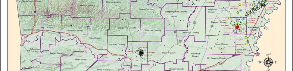
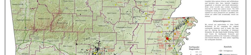
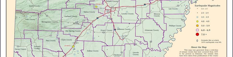
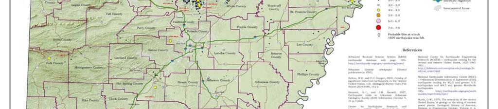


3 Historic and Recent Seismicity
4
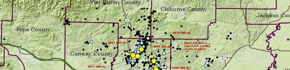
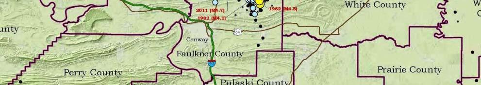
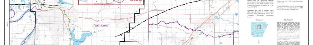
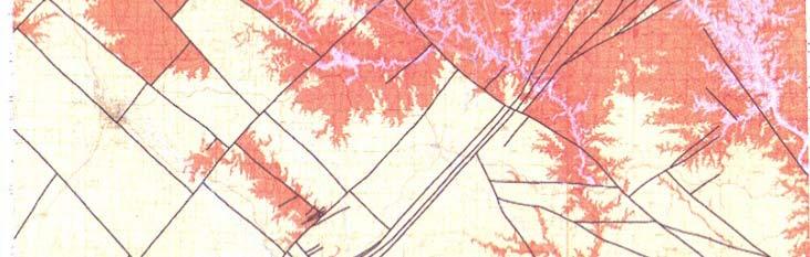
5 G-G G Swarm Overview The Guy-GreenbrierGreenbrier fault, apreviously unknown fault, is illuminated by over a 1,300 earthquakes (M 4.7) that occurred between September, 2010, and present. The fault is theoretically capable of potentially damaging M earthquake. producing a Two well-documented d cases - Rocky Mountain Arsenal, Colorado, in the 1960s and Paradox Valley, Colorado, in the 1990s - demonstrate that fluid injection into the subsurface can ti trigger earthquakes. A plausible hydraulic connection exists between the injection depths at a waste-disposal well and the nearby Guy-GreenbrierGreenbrier Fault.

6 Number of events per year: ~ 200 = M> = 624 ~ 40 = M> = = M> = = 2 Total: 1,358 (>M1.0)
7
8 Sep 2010 to Mar 2011
9
10
11 Some Potential Factors contributing to Triggered/Induced Seismicity and what we know... Faults that are critically stressed (near failure) and are favorably oriented to the regional stress. Tight injection zone rocks with low primary porosity/permeability between the grains. This pressures up the injection reservoir/aquifer quickly. Most likely the pressure front will take the path of least resistance via the joints and fractures (secondary porosity/permeability). The injection of fluids increases the pore pressure within the reservoir/aquifer of injection. Plausible hydraulic connectivity between the well(s) and the fault(s) via orthogonal joint sets and fractures. When there is a hydraulic connection between the injection reservoir/aquifer e and nearby fault(s), the potential t exists in increasing the pore pressure in the fault zone. This could change the Mohr-Coulomb criterion resulting in movement.
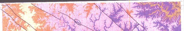
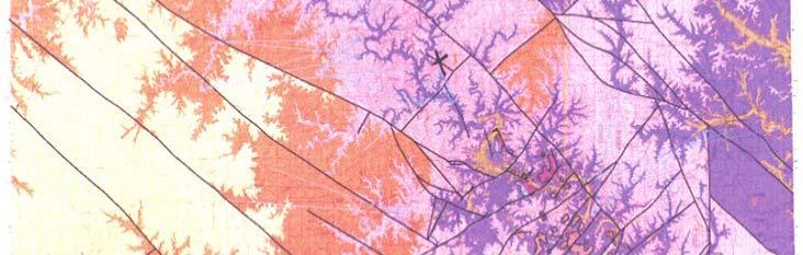
12 Structural Cross-Section SOURCE: AAPG Bulletin V. 74 (July, 1990), P , 4 Figs., 1 Table
13 Guy-Greenbrier Fault
14 Orthogonal Fracturing in the Earth s Continental Crust S. Parker Gay, Jr., 1973: summarized some 30 different studies in the literature pertinent to crustal fracturing: The earth s crust is cut by a number of set of parallel to sub-parallel deep fractures that occur pervasively throughout the globe most if not all occurred in Precambrian time these are typically paired with another set orthogonal to each other pairset and may have been reactivated numerous times (both in the Precambrian and in the Phanerozoic time. Sedimentary rocks become jointed early in their history as aresult of minor vertical movement along the basement pairsets by a bridging mechanism - this mechanism results in forming orthogonal tension joints in the overlying sedimentary rock mirroring the causative basement fractures below.


15
16 Plausible Hydraulic Connectivity Source: Imes, J. L. and Emmett, L.F., USGS, 1994 Tectonic activity and erosion results in uplift of the Ozark Plateau above sea level creating faults and fractures Major rift (New Madrid) forms on the southeast flank also contributes to regional faulting and fracturing preferential northwest- Numerous orientation southeast faults to the and fractures exhibit northeast-southwest southwest and These faults and fractures provide avenues for ground water movement through virtually impermeable rock Many of the faults and fractures in the younger overlying Paleozoic rocks in the eastern portion of the Ozarks are the result of repeated differential movement across weak zones associated with the faults in the underlying basement faults.


17 STRATIGRAPHIC SECTION GEOHYDROLOGIC UNITS BOONE Ozark Confining Unit is thin and predominately sandstone HUNTON in the Study Area ARBUCKLE St. Francois Confining Unit is missing in the Study Area (Caplin, 1960)
18 Disposal Well Comparisons Moore Estate: Total Depth: 10,500 feet Sedimentary Rock: Injection Zone: 0 to 10,500 feet 7,480 to 7,540 feet (Boone) Injection Zone: 9,300 to 10,500 feet (Arbuckle) SRE: Total Depth: 6,460 feet Sedimentary Rock: 0 to 6,460 feet Injection Zone: 5,975 to 6,460 feet (Boone and Hunton) Edgmond: Total Depth: 12,160 feet Sedimentary Rock: 0 to 12,090 feet Igneous Rock: 12,090 to 12,160 feet Injection Zone: 7,806 to 10,970 feet (Arbuckle) Trammel: Total Depth: 7,160 feet Sedimentary Rock: 0 to 7,160 feet Injection Zone: 6,503 to 6,590 feet (Boone)
19 Were the Guy-greenbrier Earthquakes Triggered by fluid injection? The Guy-Greenbrier Greenbrier fault was critically stressed prior to the start t of injection. Therefore, the Mohr-Coulomb criterion must have been changed incrementally (naturally or by human activity) shortly before or coincident with the earthquakes. The earthquakes along the Guy-GreenbrierGreenbrier fault began after the start of injection at well #1 with intense seismic activity following the start of injection at well #5. Earthquake frequency in the study area shows a strong correlation with the volume of injection at well#1 and well#5.
20 Were the Guy-greenbrier Earthquakes Triggered by fluid injection? Continued The injection of fluids increased pore pressure in the Ozark aquifer, and because of the hydraulic connection between the Ozark aquifer and the Guy-GreenbrierGreenbrier fault, pore pressure most likely increased in the fault zone. Given the spatial and temporal correlation between the UIC wells and activity on the fault, it would be an extraordinary coincidence if the earthquakes were not triggered by fluid injection.
21 References and Sources: Arkansas Geological Survey Arkansas Oil and Gas Commission Burroughs, R., K., 1988, Structural Geology of the Enola Arkansas Earthquake Swarm: Master Thesis, University of Arkansas. Cox, R.T., 2009, Tectonophysics, 474, p Gay, Jr., Parker, S., 1973, Pervasive Orthogonal Fracturing in the Earth s Continental Crust. Harrison, R., 2009, USGS PowerPoint: History and Fabric of the Region Surrounding the Northern Mississippi Embayment and the New Madrid Seismic Zone: Midcontinent U.S. Imes, J. L. and Emmett, L.F., 1994, Major geohydrologic units in and adjacent to the Ozarks Plateaus Province, Missouri, Arkansas, Kansas, and Oklahoma, U. S. Geological Survey Hydrologic Investigations Atlas, HA 711-A VanArsdale, R.B. and Schweig, E.S., III, Subsurface structure of the Eastern Arkoma Basin, The American Association of Petroleum Geologists Bulletin, V. 74, No. 7 (July 1990), P , 4Figs., 1 Table.
22 Thank You for your Attention t Any Questions???
FAQs - Earthquakes Induced by Fluid Injection
 of 1 http://earthquake.usgs.gov/learn/faq/?categoryid=46&faqid=357 4/23/2012 9:26 PM Q: Does the production of natural gas from shales cause earthquakes? If so, how are the earthquakes related to these
On May 4, 2001, central Arkansas experienced an M=4.4 earthquake followed by a
 1. Introduction On May 4, 2001, central Arkansas experienced an M=4.4 earthquake followed by a surprisingly large number of small earthquakes. We recorded about 2500 above the ambient noise level on a
Finite element modelling of fault stress triggering due to hydraulic fracturing
 Finite element modelling of fault stress triggering due to hydraulic fracturing Arsalan, Sattari and David, Eaton University of Calgary, Geoscience Department Summary In this study we aim to model fault
General Geologic Setting and Seismicity of the FHWA Project Site in the New Madrid Seismic Zone
 General Geologic Setting and Seismicity of the FHWA Project Site in the New Madrid Seismic Zone David Hoffman University of Missouri Rolla Natural Hazards Mitigation Institute Civil, Architectural & Environmental
Modeling pressure response into a fractured zone of Precambrian basement to understand deep induced-earthquake hypocenters from shallow injection
 Modeling pressure response into a fractured zone of Precambrian basement to understand deep induced-earthquake hypocenters from shallow injection S. Raziperchikolaee 1 and J. F. Miller 1 Abstract Analysis
Structural Styles and Geotectonic Elements in Northwestern Mississippi: Interpreted from Gravity, Magnetic, and Proprietary 2D Seismic Data
 Structural Styles and Geotectonic Elements in Northwestern Mississippi: Interpreted from Gravity, Magnetic, and Proprietary 2D Seismic Data Nick Loundagin 1 and Gary L. Kinsland 2 1 6573 W. Euclid Pl.,
Recent Earthquakes in Oklahoma. and Potential for Induced Seismicity Austin Holland Oklahoma State Seismologist
 Recent Earthquakes in Oklahoma and the Mid-Continent: Significance and Potential for Induced Seismicity Austin Holland Oklahoma State Seismologist Outline Seismicity Rates in Mid-continent and Oklahoma
Risk Evaluation. Todd Shipman PhD, Alberta Geological Survey/Alberta Energy Regulator November 17 th,2017 Induced Seismicity Workshop, Yellowknife NWT
 Risk Evaluation Todd Shipman PhD, Alberta Geological Survey/Alberta Energy Regulator November 17 th,2017 Induced Seismicity Workshop, Yellowknife NWT Risk Management Approach to Induced Seismicity Establishing
COGCC Underground Injection Program & Induced Seismicity
 COGCC Underground Injection Program & Induced Seismicity February 2017 Stuart Ellsworth, Engineering Manager Bob Koehler, UIC Lead, Geologic Advisor Agenda: Colorado UIC Permit Process UIC Well Construction
ENGINEER S CERTIFICATION OF FAULT AREA DEMONSTRATION (40 CFR )
") PLATTE RIVER POWER AUTHORITY RAWHIDE ENERGY STATION BOTTOM ASH TRANSFER (BAT) IMPOUNDMENTS LARIMER COUNTY, CO ENGINEER S CERTIFICATION OF FAULT AREA DEMONSTRATION (40 CFR 257.62) FOR COAL COMBUSTION RESIDUALS
PLATTE RIVER POWER AUTHORITY RAWHIDE ENERGY STATION BOTTOM ASH TRANSFER (BAT) IMPOUNDMENTS LARIMER COUNTY, CO ENGINEER S CERTIFICATION OF FAULT AREA DEMONSTRATION (40 CFR 257.62) FOR COAL COMBUSTION RESIDUALS
Regulatory Considerations for Evaluating the Potential for Induced Seismicity of a Class I Non-Hazardous Disposal Well
 Regulatory Considerations for Evaluating the Potential for Induced Seismicity of a Class I Non-Hazardous Disposal Well Chad Milligan, P.G.-SCS Engineers Craig Pangburn, P.G.-T&C Consulting Many Options
Structural Geology of the Mountains
 Structural Geology of the Mountains Clinton R. Tippett Shell Canada Limited, Calgary, Alberta clinton.tippett@shell.ca INTRODUCTION The Southern Rocky Mountains of Canada (Figure 1) are made up of several
Kansas Interdisciplinary Carbonates Consortium Proposal June 2012
 I. Integrated Sequence Stratigraphy and Bio- and Chemo- Stratigraphy of the Late Devonian-Mississippian strata II. Structural Kinematics and Mechanical Stratigraphy of the Pre- Pennsylvanian: Carbonate
Characterizing Seal Bypass Systems at the Rock Springs Uplift, Southwest Wyoming, Using Seismic Attribute Analysis*
 Characterizing Seal Bypass Systems at the Rock Springs Uplift, Southwest Wyoming, Using Seismic Attribute Analysis* Yuri Ganshin 1 and Fred McLaughlin 1 Search and Discovery Article #80483 (2015)** Posted
Concerns About the Poten/al for Induced Seismicity Associated with the Mississippian Play: Perceived or Real?
 Concerns About the Poten/al for Induced Seismicity Associated with the Mississippian Play: Perceived or Real? Aus/n Holland and Dr. G. Randy Keller Oklahoma Geological Survey University of Oklahoma 10/31/12
Fracture, Fluid Flow and Diagenetic History of the Arbuckle Group
 Fracture, Fluid Flow and Diagenetic History of the Arbuckle Group Robert H. Goldstein, Evan K. Franseen, W. Lynn Watney, Bradley King STATUS: Focused-term near completion, year 3 of 3 TIMING: Began August
Continental Landscapes
 Continental Landscapes Landscape influenced by tectonics, climate & differential weathering Most landforms developed within the last 2 million years System moves toward an equilibrium Continental Landscapes
An Investigation on the Effects of Different Stress Regimes on the Magnitude Distribution of Induced Seismic Events
 An Investigation on the Effects of Different Stress Regimes on the Magnitude Distribution of Induced Seismic Events Afshin Amini, Erik Eberhardt Geological Engineering, University of British Columbia,
GLY 155 Introduction to Physical Geology, W. Altermann. Press & Siever, compressive forces. Compressive forces cause folding and faulting.
 Press & Siever, 1995 compressive forces Compressive forces cause folding and faulting. faults 1 Uplift is followed by erosion, which creates new horizontal surface. lava flows Volcanic eruptions cover
MINIMIZING AND MANAGING POTENTIAL IMPACTS OF INJECTION INDUCED SEISMICITY FROM CLASS II DISPOSAL WELLS: PRACTICAL APPROACHES
 MINIMIZING AND MANAGING POTENTIAL IMPACTS OF INJECTION INDUCED SEISMICITY FROM CLASS II DISPOSAL WELLS: PRACTICAL APPROACHES Underground Injection Control National Technical Workgroup US Environmental
What We Know (and don t know)
") What We Know (and don t know) about the M5.1 La Habra Earthquake Dr. Robert Graves U.S. Geological Survey In collaboration with: Dr. Egill Hauksson and Dr. Thomas Göbel Caltech Dr. Elizabeth Cochran U.S.
What We Know (and don t know) about the M5.1 La Habra Earthquake Dr. Robert Graves U.S. Geological Survey In collaboration with: Dr. Egill Hauksson and Dr. Thomas Göbel Caltech Dr. Elizabeth Cochran U.S.
The Structural Analysis of Enola and Greenbrier, Arkansas Earthquake Swarms: Cause and Effect?
 University of Arkansas, Fayetteville ScholarWorks@UARK Theses and Dissertations 12-2015 The Structural Analysis of Enola and Greenbrier, Arkansas Earthquake Swarms: Cause and Effect? Minella Majenu University
Minimizing and Managing Potential Impacts of Injection-Induced Seismicity from Class II Disposal Wells: Practical Approaches
 Minimizing and Managing Potential Impacts of Injection-Induced Seismicity from Class II Disposal Wells: Practical Approaches Philip Dellinger, Chief Ground Water/UIC Section EPA Region 6 Acknowledgments
Seismicity in Texas in Relation to Active Class I Underground Injection Control Wells: Preliminary Observations
 Seismicity in Texas in Relation to Active Class I Underground Injection Control Wells: Preliminary Observations David Murry Groundwater Protection Council UIC Conference Austin, Texas February 22, 2017
Julie Shemeta, MEQ Geo Inc., WCEE Webinar 1/13/2016 1/14/2016
 1/14/16 1 Julie Shemeta, MEQ Geo Inc., WCEE Webinar 1/13/2016 1/14/2016 WSJ, Nov 16, 2015 Women s Council on Energy and the Environment (WCEE) January 13, 2016 http://www.cpr.org 1/7/2016 http://stateimpact.npr.org/texas/tag/earthquake/
Overview of the Seismic Source Characterization for the Palo Verde Nuclear Generating Station
 Overview of the Seismic Source Characterization for the Palo Verde Nuclear Generating Station Scott Lindvall SSC TI Team Lead Palo Verde SSC SSHAC Level 3 Project Tuesday, March 19, 2013 1 Questions from
Chapter 16. Mountain Building. Mountain Building. Mountains and Plate Tectonics. what s the connection?
 Chapter 16 Mountains and Plate Tectonics what s the connection? Mountain Building Most crustal deformation occurs along plate margins. S.2 Active Margin Passive Margin Mountain Building Factors Affecting
Induced Seismicity: Can it Happen in Kentucky Too?
 Induced Seismicity: Can it Happen in Kentucky Too? Seth Carpenter Seismologist Geologic Hazards Section 2015 KGS Annual Seminar Outline - What s the problem? - Earthquake magnitude - Types of induced seismic
1 of 5 12/10/2018, 2:38 PM
 1 of 5 12/10/2018, 2:38 PM The depth of the rock layer that serves as the disposal site for wastewater produced during unconventional oil extraction plays a significant role in whether that disposal triggers
From an earthquake perspective, 2011 was. Managing the Seismic Risk Posed by Wastewater Disposal. 38 EARTH April
 Liquid carbon dioxide has been injected into the Sleipner gas- and oilfield in the North Sea for 15 years without triggering any seismicity. It serves as a good example of how fluid injection can be done
Supplemental Data Data Sources for the Basement DEM
 GSA Data Repository 2017115 Stephen Marshak, Stefanie Domrois, Curtis Abert, Timothy Larson, Gary Pavlis, Michael Hamburger, Xiaotao Yang, Hersh Gilbert, and Chen Chen, 2017, The basement revealed: Tectonic
Nemaha Strike-Slip Fault Expression on 3-D Seismic Data in SCOOP Trend
 Nemaha Strike-Slip Fault Expression on 3-D Seismic Data in SCOOP Trend June 2018 Satinder Chopra, Kurt Marfurt, Folarin Kolawole, Brett M. Carpenter Fthe meaningful recognition of the faults within the
Colorado s Underground Injection Control Program: Prevention and Mitigation of Induced Seismicity
 Colorado s Underground Injection Control Program: Prevention and Mitigation of Induced Seismicity Energy & Environment Symposium April 2015 Robert P. Koehler, PhD. UIC Lead OVERVIEW What is a UIC well?
New USGS Maps Identify Potential Ground- Shaking Hazards in 2017
 New USGS Maps Identify Potential Ground- Shaking Hazards in 2017 New USGS Maps Identify Potential Ground-Shaking Hazards in 2017 The central U.S. faces continued hazards from human-induced earthquakes
On 31 October 2008 and the following day, numerous
 Dallas-Fort Worth earthquakes coincident with activity associated with natural gas production Cliff Frohlich and Eric Potter, University of Texas at Austin Chris Hayward and Brian Stump, Southern Methodist
2 Geology. 2.1 Elements of Terrane Analysis. Terrane or Terrain? Potential receptors
 2 Geology Knowledge of fractured rock geology, or terrane, provides important context for investigating contaminated sites. Tectonic forces impart characteristic structures on rock formations that influence
Geological Framework for Active Resource Plays in Oklahoma. Edith Newton Wilson, PhD Rock Whisperer LLC March 4, 2014
 Geological Framework for Active Resource Plays in Oklahoma Edith Newton Wilson, PhD Rock Whisperer LLC March 4, 2014 Oklahoma Oil Production 2000: 200,000 bopd* 2013: 300,000 bopd** 10 6 What Oklahoma
Geophysical Data Bearing on Hydrocarbon Traps and Resource Potential of the Galisteo Basin, New Mexico
 Open Journal of Geology, 2014, 4, 18-23 Published Online January 2014 (http://www.scirp.org/journal/ojg) http://dx.doi.org/10.4236/ojg.2014.41002 Geophysical Data Bearing on Hydrocarbon Traps and Resource
Determination of Geothermal Gradient in the Eastern Niger Delta Sedimentary Basin from Bottom Hole Temperatures
 Journal of Earth Sciences and Geotechnical Engineering, vol. 4, no. 3, 2014, 109-114 ISSN: 1792-9040 (print), 1792-9660 (online) Scienpress Ltd, 2014 Determination of Geothermal Gradient in the Eastern
SEDIMENTARY BASINS Red Sea Coast of Egypt. by Prof. Dr. Abbas Mansour
 SEDIMENTARY BASINS Red Sea Coast of Egypt by Prof. Dr. Abbas Mansour Sedimentary basins Sedimentary basins are, in a very broad sense, all those areas in which sediments can accumulate to considerable
Exploration Significance of Unconformity Structure on Subtle Pools. 1 Vertical structure characteristics of unconformity
 Exploration Significance of Unconformity Structure on Subtle Pools Wu Kongyou (China University of Petroleum,College of Geo-Resources and Information,Shandong Qingdao 266555) Abstract: Vertical structure
MIGRATING SWARMS OF BRITTLE-FAILURE EARTHQUAKES IN THE LOWER CRUST BENEATH MAMMOTH MOUNTAIN, CALIFORNIA
 MIGRATING SWARMS OF BRITTLE-FAILURE EARTHQUAKES IN THE LOWER CRUST BENEATH MAMMOTH MOUNTAIN, CALIFORNIA David Shelly and David Hill GRL, October 2011 Contents Tectonic Setting Long Valley Caldera Mammoth
Mountains and Mountain Building: Chapter 11
 Mountains and Mountain Building: Chapter 11 Objectives: 1)Explain how some of Earth s major mountain belts formed 2) Compare and contrast active and passive continental margins 3) Explain how compression,
Copyright McGraw-Hill Education. All rights reserved. No reproduction or distribution without the prior written consent of McGraw-Hill Education
 Copyright McGraw-Hill Education. All rights reserved. No reproduction or distribution without the prior written consent of McGraw-Hill Education Tibetan Plateau and Himalaya -southern Asia 11.00.a VE 10X
EDIMENTARY BASINS. What is a Sedimentary Basin? by Prof. Dr. Abbas Mansour
 EDIMENTARY BASINS What is a Sedimentary Basin? by Prof. Dr. Abbas Mansour WHAT IS A SEDIMENTARY BASIN? A low area on the Earth s surface relative to surroundings e.g. deep ocean basin (5-10 km deep) e.g.
KEY CHAPTER 12 TAKE-HOME QUIZ INTERNAL STRUCTURES AND PROCESSES Score Part B = / 55 PART B
 GEOLOGY 12 KEY CHAPTER 12 TAKE-HOME QUIZ INTERNAL STRUCTURES AND PROCESSES Score Part B = / 55 PART B CHAPTER 12 Isostacy and Structural Geology 1. Using the terms below, label the following diagrams and
Evolution of Continents Chapter 20
 Evolution of Continents Chapter 20 Does not contain complete lecture notes. Mountain belts Orogenesis the processes that collectively produce a mountain belt Includes folding, thrust faulting, metamorphism,
Identification of Lateral Spread Features in the Western New Madrid Seismic Zone J. David Rogers and Briget C. Doyle
 Identification of Lateral Spread Features in the Western New Madrid Seismic Zone J. David Rogers and Briget C. Doyle Department of Geological Engineering University of Missouri-Rolla rogersda@umr.edu doyle@hope.edu
Lecture Outline Friday March 2 thru Wednesday March 7, 2018
 Lecture Outline Friday March 2 thru Wednesday March 7, 2018 Questions? Lecture Exam Friday March 9, 2018 Same time, Same room Bring Pencils and WSU ID 50 question Multiple Choice, Computer Graded Interlude
Case Study of the Structural and Depositional-Evolution Interpretation from Seismic Data*
 Case Study of the Structural and Depositional-Evolution Interpretation from Seismic Data* Yun Ling 1, Xiangyu Guo 1, Jixiang Lin 1, and Desheng Sun 1 Search and Discovery Article #20143 (2012) Posted April
Delineating and Assessing Saline Ground Water Resources
 Delineating and Assessing Saline Ground Water Resources USGS Water Science Centers Arkansas Georgia OklahomA Sulfur water at Chickasaw National Recreation Area Sulphur, Oklahoma Background and Problem
Orphan Basin, Offshore Newfoundland: New seismic data and hydrocarbon plays for a dormant Frontier Basin
 Orphan Basin, Offshore Newfoundland: New seismic data and hydrocarbon plays for a dormant Frontier Basin Jerry Smee* G&G Exploration Consulting, 301 400-3rd Avenue SW, Calgary, AB, T2P 4H2 Sam Nader, Paul
Wind Mountain Project Summary Memo Feeder Program
 A Manex Resource Group Company Wind Mountain Project Summary Memo Feeder Program J.A. Kizis, Jr., February 07, 2018 Assays have been received for both holes drilled at Wind Mountain during late 2017 and
GO ON. Directions: Use the diagram below to answer question 1.
 d i a g n o s t i c t e s t : e a r t h a n d s p a c e s c i e n c e question 1. 1. What is the correct order (starting from the surface) of Earth s layers? A crust, outer core, inner core, mantle B mantle,
Elastic Rebound Theory
 Earthquakes Elastic Rebound Theory Earthquakes occur when strain exceeds the strength of the rock and the rock fractures. The arrival of earthquakes waves is recorded by a seismograph. The amplitude of
(Adapted from Report of Airborne Magnetometer Survey by Lockwood, Kessler and Bartlett, Inc.)
") PRELIMINARY INTERPRETATION REPORT AIRBORNE MAGNETOMETER SURVEY OF SOUTHERN IOWA (Adapted from Report of Airborne Magnetometer Survey by Lockwood, Kessler and Bartlett, Inc.) IOWA GEOLOGICAL SURVEY Iowa
PRELIMINARY INTERPRETATION REPORT AIRBORNE MAGNETOMETER SURVEY OF SOUTHERN IOWA (Adapted from Report of Airborne Magnetometer Survey by Lockwood, Kessler and Bartlett, Inc.) IOWA GEOLOGICAL SURVEY Iowa
Structural Style and Tectonic Evolution of the Nakhon Basin, Gulf of Thailand
 Structural Style and Tectonic Evolution of the Nakhon Basin, Gulf of Thailand Piyaphong Chenrai Petroleum Geoscience Program, Department of Geology, Faculty of Science, Chulalongkorn University, Bangkok
Chapter 6. Conclusions. 6.1 Conclusions and perspectives
 Chapter 6 Conclusions 6.1 Conclusions and perspectives In this thesis an approach is presented for the in-situ characterization of rocks in terms of the distribution of hydraulic parameters (called SBRC
KANSAS GEOLOGICAL SURVEY Open File Report LAND SUBSIDENCE KIOWA COUNTY, KANSAS. May 2, 2007
 KANSAS GEOLOGICAL SURVEY Open File Report 2007-22 LAND SUBSIDENCE KIOWA COUNTY, KANSAS Prepared by Michael T. Dealy L.G., Manager, Wichita Operations SITE LOCATION The site was approximately four miles
Seismic modeling evaluation of fault illumination in the Woodford Shale Sumit Verma*, Onur Mutlu, Kurt J. Marfurt, The University of Oklahoma
 Seismic modeling evaluation of fault illumination in the Woodford Shale Sumit Verma*, Onur Mutlu, Kurt J. Marfurt, The University of Oklahoma Summary The Woodford Shale is one of the more important resource
Seismicity and the SWD-C4A well: An ongoing UIC case study in the Denver Basin, Colorado
 Seismicity and the SWD-C4A well: An ongoing UIC case study in the Denver Basin, Colorado Ground Water Protection Council Annual Forum October 6, 2014 Chris Eisinger Stuart Ellsworth Bob Koehler I. Colorado
Mathematical Modelling of a Fault Slip Induced by Water Injection
 Mathematical Modelling of a Fault Slip Induced by Water Injection T. S. Nguyen, 1 J.Rutqvist 2 and Y. Gugliemi 2 1 Canadian Nuclear Safety Commission 2 Lawrence Berkeley National Laboratory ComGeo IV Symposium
Earth Systems Science Chapter 7. Earth Systems Science Chapter 7 11/11/2010. Seismology: study of earthquakes and related phenomena
 Earth Systems Science Chapter 7 I. Structure of the Earth II. Plate Tectonics The solid part of the earth system includes processes, just like the atmosphere and oceans. However, the time scales for processes
Soils, Hydrogeology, and Aquifer Properties. Philip B. Bedient 2006 Rice University
 Soils, Hydrogeology, and Aquifer Properties Philip B. Bedient 2006 Rice University Charbeneau, 2000. Basin Hydrologic Cycle Global Water Supply Distribution 3% of earth s water is fresh - 97% oceans 1%
Seismic Reflection Imaging across the Johnson Ranch, Valley County, Idaho
 Seismic Reflection Imaging across the Johnson Ranch, Valley County, Idaho Report Prepared for the Skyline Corporation Lee M. Liberty Center for Geophysical Investigation of the Shallow Subsurface (CGISS)
DELINEATION OF SUBTLE GEOLOGIC FEATURES BY MULTI-ATTRIBUTE SEISMIC ANALYSIS IN DICKMAN FIELD, KANSAS, A POTENTIAL SITE FOR CO2 SEQUESTRATION
 DELINEATION OF SUBTLE GEOLOGIC FEATURES BY MULTI-ATTRIBUTE SEISMIC ANALYSIS IN DICKMAN FIELD, KANSAS, A POTENTIAL SITE FOR CO2 SEQUESTRATION Presented to The Faculty of the Department of Earth and Atmospheric
Structural Geology Lab. The Objectives are to gain experience
 Geology 2 Structural Geology Lab The Objectives are to gain experience 1. Drawing cross sections from information given on geologic maps. 2. Recognizing folds and naming their parts on stereoscopic air
The Stability Of Fault Systems In The South Shore Of The. St. Lawrence Lowlands Of Québec Implications For Shale Gas Development
 The Stability Of Fault Systems In The South Shore Of The St. Lawrence Lowlands Of Québec Implications For Shale Gas Development John Brodylo, Jean-Yves Chatellier,Guillaume Matton & Michel Rheault Copyright
Downloaded 01/29/13 to Redistribution subject to SEG license or copyright; see Terms of Use at
 An integrated study of a Mississippian tripolitic chert reservoir Osage County, Oklahoma, USA Benjamin L. Dowdell*, Atish Roy, and Kurt J. Marfurt, The University of Oklahoma Summary With the advent of
Downloaded 03/27/18 to Redistribution subject to SEG license or copyright; see Terms of Use at
 Calibrating seismic fracture prediction using borehole image logs, application to the Mississippian Limestone Stephanie Cook*, Abdulmohsen Alali, Kurt J. Marfurt, Matthew J. Pranter The University of Oklahoma
Strike-Slip Faults. ! Fault motion is parallel to the strike of the fault.
 Strike-Slip Faults! Fault motion is parallel to the strike of the fault.! Usually vertical, no hanging-wall/footwall blocks.! Classified by the relative sense of motion. " Right lateral opposite block
Geomechanical Analysis of Hydraulic Fracturing Induced Seismicity at Duvernay Field in Western Canadian Sedimentary Basin
 Geomechanical Analysis of Hydraulic Fracturing Induced Seismicity at Duvernay Field in Western Canadian Sedimentary Basin Suvrat P Lele 1, Timothy Tyrrell 2, Ganeswara R Dasari 1, William A Symington 1
White Paper II Summarizing a Special Session on Induced Seismicity
 White Paper II Summarizing a Special Session on Induced Seismicity November 2013 White Paper II on Induced Seismicity Page 1 White Paper II Summarizing a Special Session on Induced Seismicity 1 Chapter
GPR AS A COST EFFECTIVE BEDROCK MAPPING TOOL FOR LARGE AREAS. Abstract
 GPR AS A COST EFFECTIVE BEDROCK MAPPING TOOL FOR LARGE AREAS Dr. Jutta L. Hager, Hager GeoScience, Inc., Waltham, MA Mario Carnevale, Hager GeoScience, Inc., Waltham, MA Abstract Hager GeoScience, Inc.
Earthquakes in Canada
 Earthquakes in Canada Maurice Lamontagne, Ph.D., ing. Geological Survey of Canada Natural Resources Canada 1 What is an Earthquake? P S P S P PS 2 2 Movement on a fault plane causes vibrations The larger
The McCully gas field in southern New Brunswick was discovered in the year 2000 on a joint drilling exploration venture by Corridor Resources Inc.
 1 The McCully gas field in southern New Brunswick was discovered in the year 2000 on a joint drilling exploration venture by Corridor Resources Inc. and Potash Corporation of Saskatchewan. Located about
Lower Skinner Valley Fill Sandstones: Attractive Exploration Targets on the Northeast Oklahoma Platform*
 Lower Skinner Valley Fill Sandstones: Attractive Exploration Targets on the Northeast Oklahoma Platform* By Jim Puckette 1 Search and Discovery Article #10050 (2003) *Adapted from presentation to Tulsa
WESTCARB Phase I Results Review
 WESTCARB Phase I Results Review Arizona Geologic Characterization Errol Montgomery Principal Errol L. Montgomery & Associates (520) 881-4912 emontgomery@elmontgomery.com November 9, 2005 Site Characterization
Crags, Cracks, and Crumples: Crustal Deformation and Mountain Building
 Crags, Cracks, and Crumples: Crustal Deformation and Mountain Building Updated by: Rick Oches, Professor of Geology & Environmental Sciences Bentley University Waltham, Massachusetts Based on slides prepared
Beneath our Feet: The 4 Layers of the Earty by Kelly Hashway
 Beneath our Feet: The 4 Layers of the Earty by Kelly Hashway The Earth is more than a giant ball made up of dirt, rocks, and minerals. The Earth may look like a giant ball from when looking at it from
Earth s Continents and Seafloors. GEOL100 Physical Geology Ray Rector - Instructor
 Earth s Continents and Seafloors GEOL100 Physical Geology Ray Rector - Instructor OCEAN BASINS and CONTINENTAL PLATFORMS Key Concepts I. Earth s rocky surface covered by of two types of crust Dense, thin,
Brittle Deformation. Earth Structure (2 nd Edition), 2004 W.W. Norton & Co, New York Slide show by Ben van der Pluijm
, 2004 W.W. Norton & Co, New York Slide show by Ben van der Pluijm") Lecture 6 Brittle Deformation Earth Structure (2 nd Edition), 2004 W.W. Norton & Co, New York Slide show by Ben van der Pluijm WW Norton, unless noted otherwise Brittle deformation EarthStructure (2 nd
Lecture 6 Brittle Deformation Earth Structure (2 nd Edition), 2004 W.W. Norton & Co, New York Slide show by Ben van der Pluijm WW Norton, unless noted otherwise Brittle deformation EarthStructure (2 nd
Mountains Rise and Valleys Sink: Geology Demonstrates Psalm 104:8
 Chapter 5 Mountains Rise and Valleys Sink: Geology Demonstrates Psalm 104:8 Is there any geological evidence that at the end of the Flood the mountains rose and the valleys sank draining the Floodwater?
Tectonic Interpretation Using Potential Field Data for the Sweetgrass Arch Area, Montana-Alberta, Saskatchewan
 Tectonic Interpretation Using Potential Field Data for the Sweetgrass Arch Area, Montana-Alberta, Saskatchewan Clark Jorgensen Big Sky Geophysics, Bozeman, Montana ABSTRACT I performed a basement tectonic
Unconformities are depositional contacts that overlie rocks distinctly older than they are. They are often called gaps in the sedimentary record.
 UNCONFORMITIES Unconformities are depositional contacts that overlie rocks distinctly older than they are. They are often called gaps in the sedimentary record. The contact represents time when no sediment
A. rift valley B. deep trench C. volcanic cone D. uplifted mountain. A. a volcanic island arc B. a large watershed area
 DC Practice Test Dynamic Crust PRCTICE TEST Zimm's Earth Science 2013 1. Which feature would most likely be forming at converging continental tectonic plate boundaries?. rift valley. deep trench C.
Groundwater Resources of Missouri. Cynthia Brookshire, R. G.
 Groundwater Resources of Missouri Cynthia Brookshire, R. G. GROUNDWATER... Water beneath the Earth s surface within a zone of saturation AQUIFER... A geologic formation or group of formations that are
A century of oil-field operations and earthquakes in the greater Los Angeles Basin, southern California
 A century of oil-field operations and earthquakes in the greater Los Angeles Basin, southern California Egill Hauksson 1, Thomas Göbel 1, Jean-Paul Ampuero 1, and Elizabeth Cochran 2 Downloaded 06/03/15
The Geology of the Arbuckle Group in the Midcontinent: Sequence Stratigraphy, Reservoir Development, and the Potential for Hydrocarbon Exploration*
 The Geology of the Arbuckle Group in the Midcontinent: Sequence Stratigraphy, Reservoir Development, and the Potential for Hydrocarbon Exploration* Richard D. Fritz 1, Patrick Medlock 2, Michael J. Kuykendall
Deformation of Rocks. Orientation of Deformed Rocks
 Deformation of Rocks Folds and faults are geologic structures caused by deformation. Structural geology is the study of the deformation of rocks and its effects. Fig. 7.1 Orientation of Deformed Rocks
ENTERGY INDEPENDENCE PLANT EAST AND WEST RECYCLE PONDS DEMONSTRATION OF COMPLIANCE WITH EPA CCR RULE SITING CRITERIA , FAULT AREAS.
 ENTERGY INDEPENDENCE PLANT EAST AND WEST RECYCLE PONDS DEMONSTRATION OF COMPLIANCE WITH EPA CCR RULE SITING CRITERIA 257.62, FAULT AREAS Prepared for Entergy Arkansas, Inc. PO Box 551 Little Rock, AR 72203
The Geology of Two Lights State Park. Cape Elizabeth, Maine
 Maine Geologic Facts and Localities June, 2002 Cape Elizabeth, Maine 43 33 33.48 N, 70 12 13.32 W Text by Henry N. Berry IV and Robert G. Marvinney, Department of Agriculture, Conservation & Forestry 1
Earth Science Lesson Plan Quarter 3, Week 7, Day 1
 Earth Science Lesson Plan Quarter 3, Week 7, Day 1 Outcomes for Today Standard Focus: PREPARE 1. Background knowledge necessary for today s reading. Continental ice sheets increase the weight of the Earth
Earth Science, (Tarbuck/Lutgens) Chapter 10: Mountain Building
 Chapter 10: Mountain Building") Earth Science, (Tarbuck/Lutgens) Chapter 10: Mountain Building 1) A(n) fault has little or no vertical movements of the two blocks. A) stick slip B) oblique slip C) strike slip D) dip slip 2) In a(n) fault,
Earth Science, (Tarbuck/Lutgens) Chapter 10: Mountain Building 1) A(n) fault has little or no vertical movements of the two blocks. A) stick slip B) oblique slip C) strike slip D) dip slip 2) In a(n) fault,
What Causes Rock to Deform?
 Crustal Deformation Earth, Chapter 10 Chapter 10 Crustal Deformation What Causes Rock to Deform? Deformation is a general term that refers to all changes in the shape or position of a rock body in response
Subsurface Structural Analysis Using Well Logs to Study Faults of the Lower Atokan Formation in the Arkoma Basin, Northcentral Arkansas
 IOSR Journal of Environmental Science, Toxicology and Food Technology (IOSR-JESTFT) e-issn: 2319-2402,p- ISSN: 2319-2399.Volume 11, Issue 5 Ver. II (May. 2017), PP 65-77 www.iosrjournals.org Subsurface
Enhanced remote earthquake triggering at fluid injection sites in the Midwestern US
 Enhanced remote earthquake triggering at fluid injection sites in the Midwestern US Nicholas van der Elst 1 Heather Savage 1 Katie Keranen 2 Geoff Abers 1 1 Lamont-Doherty Earth Observatory 2 Cornell University
Topic 12: Dynamic Earth Pracatice
 Name: Topic 12: Dynamic Earth Pracatice 1. Earth s outer core is best inferred to be A) liquid, with an average density of approximately 4 g/cm 3 B) liquid, with an average density of approximately 11
Finding Large Capacity Groundwater Supplies for Irrigation
 Finding Large Capacity Groundwater Supplies for Irrigation December 14, 2012 Presented by: Michael L. Chapman, Jr., PG Irrigation Well Site Evaluation Background Investigation Identify Hydrogeologic Conditions