Evidence Linking Surface Lineaments, Deep-Seated Faults and Fracture-Controlled Fluid Movement in the Williston Basin
|
|
|
- Gilbert Goodman
- 6 years ago
- Views:
Transcription
1 Evidence Linking Surface Lineaments, Deep-Seated Faults and Fracture-Controlled Fluid Movement in the Williston Basin Lynden Penner J.D. Mollard and Associates Limited Regina, SK Canada 14 th Williston Basin Petroleum Conference & Prospect Expo May 7-9, 2006, Minot ND
2 Outline Introduction Northern Williston Basin Regional Lineament Study Light hydrocarbon soil gas migration Groundwater movement Conclusions Acknowledgements


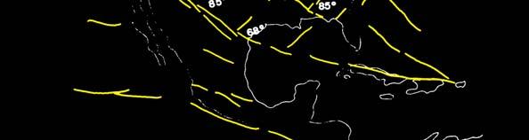
3 Introduction Airphoto lineaments Regional topographic lineaments


4 Introduction Fracture zone in Ordovician dolomite, Northwest Territories
5 Introduction
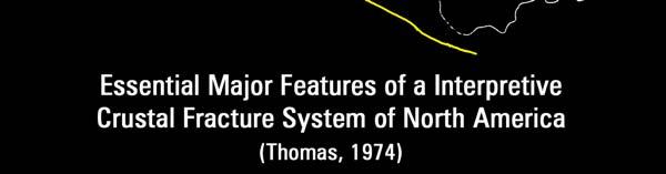
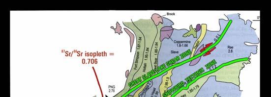
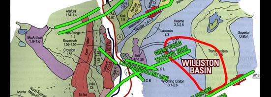
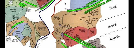
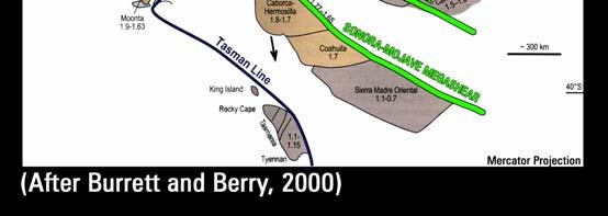
6 Introduction Rodinia Reconstruction ~0.8Ga
7 Outline Introduction Northern Williston Basin Regional Lineament Study Light hydrocarbon soil gas migration Groundwater movement Conclusions Acknowledgements


8 Northern Williston Basin Regional Lineament Study Regina Weyburn Phase 1 CO 2 EOR Area 1500 m 3200 m
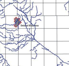
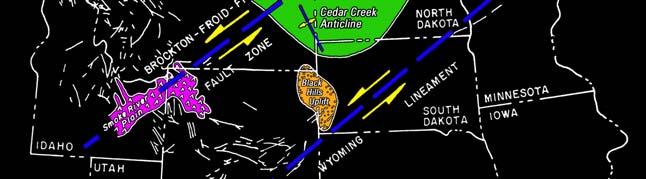
9 Shaded-Relief Map of the Study Area Saskatoon Cypress Hills Swift Current Lineament Missouri Coteau Swift Current Platform Study Area Brockton-Froid Fault Zone
")

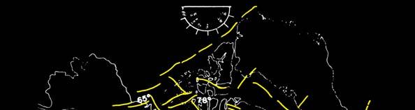
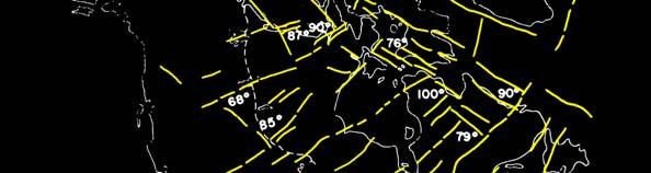
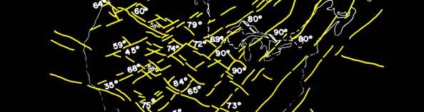
10 Dominant lineament trends (N=8,618) Lineaments and Lineament Zones in the Study Area
")
")
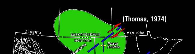
 (Bunge 2000) Michigan Basin")
11 Lineament and joint orientations Joints in drift and bedrock outcrop (N=7320) Stauffer and Gendzwill (1987) Airphoto and satellite lineaments (N=13,122) Weyburn field reservoir fractures (N=88) (Bunge 2000) Michigan Basin (Holst, 1982)
12 Snake River Plain Idaho Maximum horizontal crustal stress direction in Western Canada <10 Ma (Edmunds et al., 1994) Ma (from Alt and Hyndman, 1995)

13 Horizontal separation between faults and lineament zones 80% within 2000m 2000 m 47% within 500m Length of section = 37.1 km 2000 m


14 Aeromagnetic Data (Gedco) 120 km Precambrian and Deadwood Wells ~7km 200 km East-west magnetic depth solutions profile

15 Fault Detection Using Aeromagnetic, Seismic and Surface Data 85 km 50 km
16 Missouri Coteau Escarpment Canada Canada USA USA

17 Structure Associated with the Missouri Coteau Escarpment Missouri Coteau Escarpment Missouri Coteau Escarpment cby-7w L=48 km cbs-8 L=68 km
 Lea Park Fm Isopach (Upper Cretaceous; Depth")
18 Regional Isopach Trends Associated with the Missouri Coteau Escarpment Winnipegosis Fm Isopach (Devonian; Depth ~2,300m) Lea Park Fm Isopach (Upper Cretaceous; Depth ~480m)

19 Brockton-Froid Fault Zone Canada USA
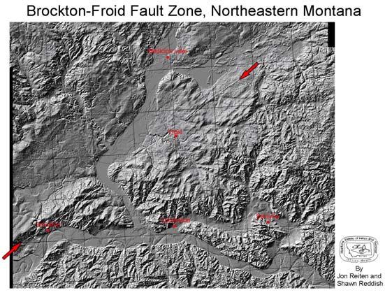

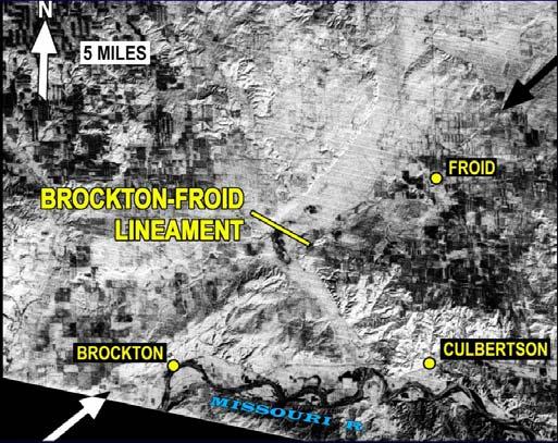
20 Brockton-Froid Fault Zone Digital Elevation Model LandSat Image


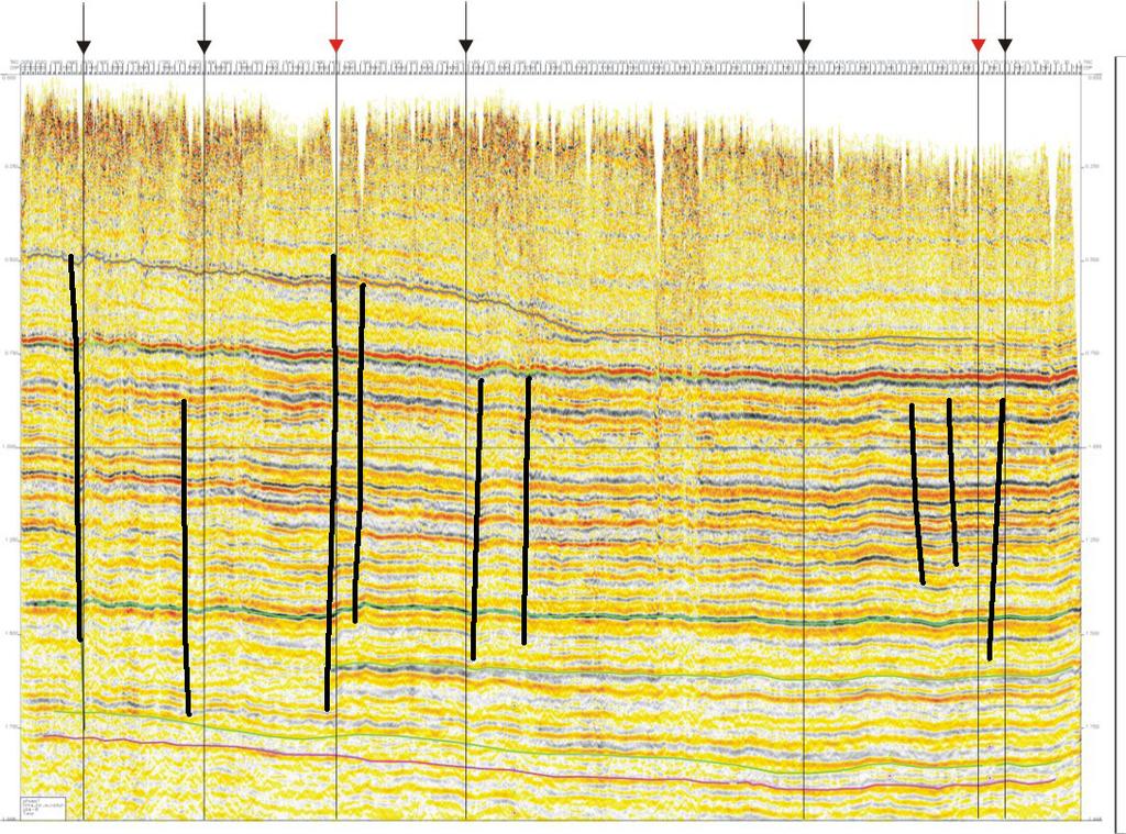
21 Brockton-Froid Fault Zone Seismic Section Strike-slip structure along extension of Brockton-Froid fault zone (Sule 2003)


22 Regional Isopach Trends Associated with the Brockton-Froid Fault Zone Winnipegosis Fm Isopach (Devonian; Depth ~2,300m) Lea Park Fm Isopach (Upper Cretaceous; Depth ~480m)
23 Outline Introduction Northern Williston Basin Regional Lineament Study Light hydrocarbon soil gas migration Groundwater movement Conclusions Acknowledgements

24 Light Hydrocarbon Soil Gas Migration


25 SW Saskatchewan High Light Hydrocarbon Magnitudes Detected On Surface Lineaments SE Saskatchewan
26 Outline Introduction Northern Williston Basin Regional Lineament Study Light hydrocarbon soil gas migration Groundwater movement Conclusions Acknowledgements


27 Groundwater Exploration Sec W4 100m Saline groundwater discharge along an airphoto lineament SE Alberta
28 Conclusions Our studies demonstrate a multi-spatial and multi-temporal link between lineaments, faults and fracture-controlled fluid movement 1. Small-scale lineaments reflect regional systematic joints (open-mode fractures) that influence active gas and groundwater migration. 2. Intermediate-scale lineaments reflect deeper structures within the sedimentary rock column that may be associated fluid movement within specific formations (e.g., salt dissolution, fracture permeability in reservoirs) 3. Large-scale lineaments reflect long-lived (ancient and reactivated) basement structures and may be associated with ancient slow-moving subsurface fluid flow systems.
29 Acknowledgements Weyburn CO 2 Monitoring Project Saskatchewan Industry and Resources University of Saskatchewan, Geophysics Dept. Gedco Geophysical Exploration & Development Corp.
30 Thank-you
Horizontal gradient and band-pass filter of aeromagnetic data image the subsurface structure; Example from Esh El Mellaha Area, Gulf of Suez, Egypt.
 Horizontal gradient and band-pass filter of aeromagnetic data image the subsurface structure; Example from Esh El Mellaha Area, Gulf of Suez, Egypt. Essam Aboud 1, Serguei Goussev 2, Hassan Hassan 2, Suparno
General Geologic Setting and Seismicity of the FHWA Project Site in the New Madrid Seismic Zone
 General Geologic Setting and Seismicity of the FHWA Project Site in the New Madrid Seismic Zone David Hoffman University of Missouri Rolla Natural Hazards Mitigation Institute Civil, Architectural & Environmental
Williston Basin Architecture and Hydrocarbon Potential: A Targeted Geoscience Initiative Project 1
 Williston Basin Architecture and Hydrocarbon Potential: A Targeted Geoscience Initiative Project 1 S.G. Whittaker Whittaker, S.G. (2005): Williston Basin architecture and hydrocarbon potential: A Targeted
Origin and Evolution of Formation Waters in the West-Central Part of the Alberta Basin
 Page No. 004-1 Origin and Evolution of Formation Waters in the West-Central Part of the Alberta Basin Karsten Michael* University of Alberta, 1-26 ESB, Edmonton, AB T6G 2E3 karsten@ualberta.ca and Stefan
Available online at ScienceDirect. Energy Procedia 63 (2014 ) GHGT-12
 GHGT-12") Available online at www.sciencedirect.com ScienceDirect Energy Procedia 63 (2014 ) 2977 2984 GHGT-12 Characterization of the Aquistore CO 2 project storage site, Saskatchewan, Canada. Ben Rostron a *,
Available online at www.sciencedirect.com ScienceDirect Energy Procedia 63 (2014 ) 2977 2984 GHGT-12 Characterization of the Aquistore CO 2 project storage site, Saskatchewan, Canada. Ben Rostron a *,
PRECAMBRIAN CRYSTALLINE AQUIFER (METAMORPHIC ROCKS)
") HAYWARD QUADRANGLE: Groundwater Production by Aquifer In the 56-square-mile area of the Hayward Quadrangle, groundwater is produced from metamorphic crystalline rocks of the Precambrian basement (in the
HAYWARD QUADRANGLE: Groundwater Production by Aquifer In the 56-square-mile area of the Hayward Quadrangle, groundwater is produced from metamorphic crystalline rocks of the Precambrian basement (in the
Williston Basin Architecture and Hydrocarbon Potential in Eastern Saskatchewan and Western Manitoba
 Williston Basin Architecture and Hydrocarbon Potential in Eastern Saskatchewan and Western Manitoba Kim Kreis, Benoit Beauchamp 1, Ruth Bezys 2 Carol Martiniuk 3, and Steve Whittaker Kreis, L.K., Beauchamp,
GPR AS A COST EFFECTIVE BEDROCK MAPPING TOOL FOR LARGE AREAS. Abstract
 GPR AS A COST EFFECTIVE BEDROCK MAPPING TOOL FOR LARGE AREAS Dr. Jutta L. Hager, Hager GeoScience, Inc., Waltham, MA Mario Carnevale, Hager GeoScience, Inc., Waltham, MA Abstract Hager GeoScience, Inc.
How to Log Core (With Examples from the Williston Basin of Southeast Saskatchewan)
") How to Log Core (With Examples from the Williston Basin of Southeast Saskatchewan) D.M.Kent ( D.M.Kent Geological Consulting Ltd., Regina, Sask.), and J.H.Lake, (Lake Geological Services Inc, Swift Current,
How to Log Core (With Examples from the Williston Basin of Southeast Saskatchewan) D.M.Kent ( D.M.Kent Geological Consulting Ltd., Regina, Sask.), and J.H.Lake, (Lake Geological Services Inc, Swift Current,
Reservoir Characteristics of the Birdbear Formation in West- Central Saskatchewan
 Reservoir Characteristics of the Birdbear Formation in West- Central Saskatchewan Chao Yang Petroleum Geology Branch Exploration and Geological Services Division Saskatchewan Ministry of Energy and Resources
Tectonics and Hydrocarbon System, East Gobi Basin, Mongolia. Gary Prost, ConocoPhillips Canada, Calgary
 Tectonics and Hydrocarbon System, East Gobi Basin, Mongolia Gary Prost, ConocoPhillips Canada, Calgary Project Objectives (a joint project of Gulf Canada and ROC Oil) What structures can be expected in
IRAQ. Target Exploration. Geodynamic Evolutions of The Sedimentary Basins of. This study is a major reference for Petroleum
 barr Target Exploration Target Exploration Geodynamic Evolutions of The Sedimentary Basins of IRAQ This study is a major reference for Petroleum Explorationists on the tectonics, stratigraphy, sedimentary
OIL AND GAS PLAYS OF THE MICHIGAN BASIN, SOUTHERN ONTARIO. Terry Carter, Consulting Geologist London, Ontario
 OIL AND GAS PLAYS OF THE MICHIGAN BASIN, SOUTHERN ONTARIO Terry Carter, Consulting Geologist London, Ontario 1 Ontario Petroleum Industries Oil and Natural Gas 1250 oil wells, 1200 gas wells, annual production
Structural Style in the Peel Region, NWT and Yukon
 Structural Style in the Peel Region, NWT and Yukon Adriana Taborda* Husky Energy and University of Calgary, Calgary, AB Adriana.Taborda@huskyenergy.ca and Deborah Spratt University of Calgary, Calgary,
Devonian Petroleum Systems and Exploration Potential, Southern Alberta, Part 3 Core Conference
 Devonian Petroleum Systems and Exploration Potential, Southern Alberta, Part 3 Core Conference Andy Mort (1), Leonard Stevens (2), Richard Wierzbicki (2) Abstract Part 1: Devonian Petroleum Systems Dr.
Ladyfern, N.E.B.C.: Major Gas Discovery in the Devonian Slave Point Formation
 Page No. 112-1 Ladyfern, N.E.B.C.: Major Gas Discovery in the Devonian Slave Point Formation Thomas Boreen and Kelvin Colquhoun, Apache Canada Ltd., Calgary, Alberta ABSTRACT The Upper Devonian Slave Point
Bonn, Germany MOUTAZ DALATI. General Organization for Remote Sensing ( GORS ), Syria Advisor to the General Director of GORS,
, Syria Advisor to the General Director of GORS,") Bonn, Germany Early Warning System is needed for Earthquakes disaster mitigation in Syria Case Study: Detecting and Monitoring the Active faulting zones along the Afro-Arabian-Syrian Rift System MOUTAZ
Bonn, Germany Early Warning System is needed for Earthquakes disaster mitigation in Syria Case Study: Detecting and Monitoring the Active faulting zones along the Afro-Arabian-Syrian Rift System MOUTAZ
Geologic Considerations of Shallow SAGD Caprock; Seal Capacity, Seal Geometry and Seal Integrity, Athabasca Oilsands, Alberta Canada
 Geologic Considerations of Shallow SAGD Caprock; Seal Capacity, Seal Geometry and Seal Integrity, Athabasca Oilsands, Alberta Canada Gordon T. Stabb, Michael Webb Durando Resources Corp, Suncor Energy
Ministry of Oil and Minerals Petroleum Exploration & Production Authority BLOCK 85 (Al Uqlah North)
") Ministry of Oil and Minerals Petroleum Exploration & Production Authority BLOCK 85 (Al Uqlah North) The Al Uqlah North Block (85) occupies an area of 597 km 2 in the Sabatayn Basin in the province of Shabwah
Ministry of Oil and Minerals Petroleum Exploration & Production Authority BLOCK 85 (Al Uqlah North) The Al Uqlah North Block (85) occupies an area of 597 km 2 in the Sabatayn Basin in the province of Shabwah
Mapping Magnetic Lineaments in the Foothills of Northeastern British Columbia using 2-D Wavelet Transform
 Mapping Magnetic Lineaments in the Foothills of Northeastern British Columbia using 2-D Wavelet Transform Hassan Hassan* GEDCO, Calgary, Alberta, Canada hassan@gedco.com Abstract Summary This work describes
Seismic Delineation of the Prairie Evaporite Dissolution Edge in South-central Saskatchewan
 Seismic Delineation of the Prairie Evaporite Dissolution Edge in South-central Saskatchewan H. Hamid 1, I.B. Morozov 1, and L.K. Kreis Hamid, H., Morozov, I.B., and Kreis, L.K. (2005): Seismic delineation
Investigation of Devonian Unconformity Surface Using Legacy Seismic Profiles, NE Alberta
 Investigation of Devonian Unconformity Surface Using Legacy Seismic Profiles, NE Alberta Elahe P. Ardakani and Douglas R. Schmitt Department of Physics, University of Alberta Summary The Devonian Grosmont
East Gainsborough, Saskatchewan: a Prairie Evaporite salt dissolution and Mississippian erosional unconformity trap
 East Gainsborough, Saskatchewan: a Prairie Evaporite salt dissolution and Mississippian erosional unconformity trap Andre St.Onge* and Eric Strachan Upton Resources Inc., 3900, 205-5 th Avenue S.W., Calgary,
Assessing our untapped energy resources. Derek Reay Geological Survey of Northern Ireland
 Assessing our untapped energy resources Derek Reay Geological Survey of Northern Ireland Talk Outline Northern Ireland energy market Oil and Gas Exploration Description Exploration risks Application of
OZ SEEBASE TM. Datasets. Digital Elevation Model
 Digital Elevation Model 10 Digital Elevation Models (DEM s) often show the youngest structures, and any active geological structures. They are widely used for neotectonic analysis. The composition of eroding
Potential Field investigation of Williston Basin Basement
 Potential Field investigation of Williston Basin Basement Jiakang Li* and Igor Morozov, University of Saskatchewan, Canada Summary Major faults and domains are identified in the Precambrian basement of
Mapping Basement Structures in the Peace River Arch of Alberta Using Monogenic Signal Decomposition of Magnetic Data
 Mapping Basement Structures in the Peace River Arch of Alberta Using Monogenic Signal Decomposition of Magnetic Data Hassan H. Hassan*, CGG Gravity & Magnetic Services, Calgary, Alberta, Canada Hassan.Hassan@CGG.com
Continental Landscapes
 Continental Landscapes Landscape influenced by tectonics, climate & differential weathering Most landforms developed within the last 2 million years System moves toward an equilibrium Continental Landscapes
HDR/EGS POTENTIAL OF THE VILKYCIAI AREA, WEST LITHUANIA
 HDR/EGS POTENTIAL OF THE VILKYCIAI AREA, WEST LITHUANIA Prepared by Saulius Sliaupa, Dainius Michelevicius, Gediminas Motuza, Larisa Korabliova, Kirstina Ciuraite West Lithuania is situated in the central
CANADA S LANDFORM REGIONS
 CANADA S LANDFORM REGIONS Canada s Regions Canada is divided into Eight major regions. A Region is an area that is defined on the basis of the presence or absence of certain characteristics: Age of rock
Structural Modelling of Inversion Structures: A case study on South Cambay Basin
 10 th Biennial International Conference & Exposition P 065 Structural Modelling of Inversion Structures: A case study on South Cambay Basin Dr. Mayadhar Sahoo & S.K Chakrabarti Summary The inversion in
Differentiation of chloride source using stable chlorine isotopes
 Differentiation of chloride source using stable chlorine isotopes RemTech 2009 Banff, Alberta October 14-16 2009 Dr. Alec Blyth and Tom Anthony 1 1 currently City of Calgary Background: DOW Chemical Canada
Ministry of Oil and Minerals Petroleum Exploration & Production Authority BLOCK 80 (WADI SARR)
") Ministry of Oil and Minerals Petroleum Exploration & Production Authority BLOCK 80 (WADI SARR) The Wadi Sarr Block (80) occupies an area of 1961 km 2 on the Sayun- Masilah Basin in the central Yemen. Block
Ministry of Oil and Minerals Petroleum Exploration & Production Authority BLOCK 80 (WADI SARR) The Wadi Sarr Block (80) occupies an area of 1961 km 2 on the Sayun- Masilah Basin in the central Yemen. Block
Available online at GHGT-9
 Available online at www.sciencedirect.com Energy Procedia 100 (2009) (2008) 2887 2894 000 000 Energy Procedia www.elsevier.com/locate/procedia www.elsevier.com/locate/xxx GHGT-9 CO 2 storage risk minimization
Distribution of Overpressure and its Prediction in Saurashtra Dahanu Block, Western Offshore Basin, India*
 Distribution of Overpressure and its Prediction in Saurashtra Dahanu Block, Western Offshore Basin, India* Kanak R. Nambiar 1, B.K. Singh 2, R.N. Goswami 2, and K.R.K. Singh 2 Search and Discovery Article
Mapping groundwater conditions of deep saline formations in West-Central Alberta
 Mapping groundwater conditions of deep saline formations in West-Central Alberta Nevenka Nakevska, Jordan Brinsky, Amandeep Singh WaterTech 2017, April 3-5, Banff Area of Interest Grande Prairie Swan Hills
Penn West Pembina Cardium CO 2 EOR seismic monitoring program
 Penn West Pembina Cardium CO 2 EOR seismic monitoring program Don Lawton Marcia Coueslan, Fuju Chen Henry Bland, Abdullah Alshuhail University of Calgary Calgary, Alberta, Canada Penn West Petroleum CO
L.K. Carr 1, R.J. Korsch 1, A.J. Mory 2, R.M. Hocking 2, S.K. Marshall 1, R.D. Costelloe 1, J. Holzschuh 1, J.L. Maher 1
 STRUCTURAL AND STRATIGRAPHIC ARCHITECTURE OF WESTERN AUSTRALIA S FRONTIER ONSHORE SEDIMENTARY BASINS: THE WESTERN OFFICER AND SOUTHERN CARNARVON BASINS L.K. Carr 1, R.J. Korsch 1, A.J. Mory 2, R.M. Hocking
HRAM FAULT INTERPRETATION USING MAGPROBE DEPTH ESTIMATES AND NON- TRADITIONAL FILTERING
 HRAM FAULT INTERPRETATION USING MAGPROBE DEPTH ESTIMATES AND NON- TRADITIONAL FILTERING Serguei A. Goussev 1, Robert A. Charters 1, Hassan H. Hassan 1, John W. Peirce 1 and James A. Genereux 2 Canadian
East Africa Transform Margin The View from Tanzania and Madagascar
 East Africa Transform Margin The View from Tanzania and Madagascar Richard Higgins and Mark Sofield 10 th PESGB/HGS Conference on African E & P, London, September 7-8, 2011 Acknowledgements Legal Notice:
Recap and Integrated Rock Mechanics and Natural Fracture Study in the Bakken Formation, Williston Basin
 Recap and Integrated Rock Mechanics and Natural Fracture Study in the Bakken Formation, Williston Basin EERC, 2011 Cosima Theloy PhD Candidate Department of Geology and Geological Engineering Colorado
Calcite Cements in Middle Devonian Dunedin Formation:
 Geochemistry of the Fracture-Filling Dolomite and Calcite Cements in Middle Devonian Dunedin Formation: Implication for the Strata Dolomitization Model Sze-Shan Yip 1, Hairuo Qing 1 and Osman Salad Hersi
Characterization of Induced Seismicity in a Petroleum Reservoir: A Case Study
 Characterization of Induced Seismicity in a Petroleum Reservoir: A Case Study Edmond Sze, M. Nafi Toksöz, and Daniel R. Burns Earth Resources Laboratory Dept. of Earth, Atmospheric and Planetary Sciences
Subsurface temperature analysis along the Williston Basin, Canada for geothermal energy prospecting
 ISSN: 2455-4227 Impact Factor: RJIF 5.12 www.allsciencejournal.com Volume 2; Issue 5; September 2017; Page No. 27-32 DOI: https://doi.org/10.22271/allscience.2017.v2.i5.06 Subsurface temperature analysis
Structural Deformation and Karst in the Devonian Waterways Formation: Examples from Outcrops along the Athabasca River*
 Structural Deformation and Karst in the Devonian Waterways Formation: Examples from Outcrops along the Athabasca River* Chris L. Schneider 1 and Matthias Grobe 2 Search and Discovery Article #51073 (2015)
Beneath the Oil Sands: Stratigraphy and Structural Features of the Devonian of Northeast Alberta, Canada*
 Beneath the Oil Sands: Stratigraphy and Structural Features of the Devonian of Northeast Alberta, Canada* Chris L. Schneider 1, Shilong Mei 1, Matthias Grobe 1, and Kristine Haug 1 Search and Discovery
Seismic Reflection Imaging across the Johnson Ranch, Valley County, Idaho
 Seismic Reflection Imaging across the Johnson Ranch, Valley County, Idaho Report Prepared for the Skyline Corporation Lee M. Liberty Center for Geophysical Investigation of the Shallow Subsurface (CGISS)
Summary. Introduction
 1540160 Using Microseismicity to Understand Subsurface Fracture Systems and Increase the Effectiveness of Completions: Eagle Ford Shale, TX John P. Detring 1 and Sherilyn Williams-Stroud 2 1. Analysis,
A comparison of structural styles and prospectivity along the Atlantic margin from Senegal to Benin. Peter Conn*, Ian Deighton* & Dario Chisari*
 A comparison of structural styles and prospectivity along the Atlantic margin from Senegal to Benin Overview Peter Conn*, Ian Deighton* & Dario Chisari* * TGS, Millbank House, Surbiton, UK, KT6 6AP The
Steve Whittaker, Petroleum Technology Research Centre Stephen Bend, University of Regina Ben Rostron, University of Alberta Gavin Jensen, Ministry of
 Steve Whittaker, Petroleum Technology Research Centre Stephen Bend, University of Regina Ben Rostron, University of Alberta Gavin Jensen, Ministry of Energy & Resources Williston Basin Petroleum Conference
Tectonic Interpretation Using Potential Field Data for the Sweetgrass Arch Area, Montana-Alberta, Saskatchewan
 Tectonic Interpretation Using Potential Field Data for the Sweetgrass Arch Area, Montana-Alberta, Saskatchewan Clark Jorgensen Big Sky Geophysics, Bozeman, Montana ABSTRACT I performed a basement tectonic
Highstand Stacked Tidal Flat / Standing Water Evaporite Cycles of the Midale Evaporite in Southeast Saskatchewan, Mississippian Williston Basin*
 Highstand Stacked Tidal Flat / Standing Water Evaporite Cycles of the Midale Evaporite in Southeast Saskatchewan, Mississippian Williston Basin* J. H. Lake 1 and D. M. Kent 2 Search and Discovery Article
THESE TERMS GOVERN YOUR USE OF THIS DOCUMENT
 THESE TERMS GOVERN YOUR USE OF THIS DOCUMENT ISBN 978-1-4606-4599-4 (DVD) ISBN 978-1-4606-4598-7 (zip file) Your use of this electronic information product ( EIP ), and the digital data files contained
Follow this and additional works at: Part of the Geology Commons
 Western Michigan University ScholarWorks at WMU Michigan Geological Repository for Research and Education Geosciences 2016 Geology of Michigan William B. Harrison III Michigan Geological Repository for
Search and Discovery Article #10327 (2011) Revision posted September 26, 2011; original posted May 31, 2011
 Revision posted September 26, 2011; original posted May 31, 2011") Hydrocarbon Systems in the Intracratonic Hudson Bay Basin: A New Prospective Frontier in the Canadian North* (Geological Setting and Petroleum Potential of the Paleozoic Hudson Platform, Northern Canada**)
Hydrocarbon Systems in the Intracratonic Hudson Bay Basin: A New Prospective Frontier in the Canadian North* (Geological Setting and Petroleum Potential of the Paleozoic Hudson Platform, Northern Canada**)
Integrated well log and 3-D seismic data interpretation for the Kakinada area of KG PG offshore basin
 IOSR Journal of Applied Geology and Geophysics (IOSR-JAGG) e-issn: 2321 0990, p-issn: 2321 0982.Volume 5, Issue 4 Ver. II (Jul. Aug. 2017), PP 01-05 www.iosrjournals.org Integrated well log and 3-D seismic
Geomechanics for reservoir and beyond Examples of faults impact on fluid migration. Laurent Langhi Team Leader August 2014
 Geomechanics for reservoir and beyond Examples of faults impact on fluid migration Laurent Langhi Team Leader August 2014 Reservoir Geomechanics It is critical to understand the mechanical behaviour of
ANGOLA OFFSHORE LICENSING 2007 BLOCK 46
 AGOLA OFFHOR LICIG 2007 BLOCK 46 DATA BA AVAILABILITY Figure 1 shows the seismic data available on Block 46. Fig. 1 Commercial 2D surveys: esterngeco: 794 km. GX Technology: 116 km. Commercial 3D surveys:
APPENDIX C GEOLOGICAL CHANCE OF SUCCESS RYDER SCOTT COMPANY PETROLEUM CONSULTANTS
 APPENDIX C GEOLOGICAL CHANCE OF SUCCESS Page 2 The Geological Chance of Success is intended to evaluate the probability that a functioning petroleum system is in place for each prospective reservoir. The
Crustal Deformation Earth - Chapter Pearson Education, Inc.
 Crustal Deformation Earth - Chapter 10 Structural Geology Structural geologists study the architecture and processes responsible for deformation of Earth s crust. A working knowledge of rock structures
Sequence Stratigraphy of the Upper Cretaceous Niobrara Formation, A Bench, Wattenberg Field, Denver Julesburg Basin, Colorado*
 Sequence Stratigraphy of the Upper Cretaceous Niobrara Formation, A Bench, Wattenberg Field, Denver Julesburg Basin, Colorado* Lisa E. Remington LaChance 1 and Mark C. Robinson 1 Search and Discovery Article
L.K. Carr 1, R.J. Korsch 1, A.J. Mory 2, R.M. Hocking 2, S.K. Marshall 1, R.D. Costelloe 1, J. Holzschuh 1, J.L. Maher 1. Australia.
 STRUCTURAL AND STRATIGRAPHIC ARCHITECTURE OF WESTERN AUSTRALIA S FRONTIER ONSHORE SEDIMENTARY BASINS: THE WESTERN OFFICER AND SOUTHERN CARNARVON BASINS L.K. Carr 1, R.J. Korsch 1, A.J. Mory 2, R.M. Hocking
Ministry of Oil and Minerals Petroleum Exploration & Production Authority BLOCK 6 (Iryam)
") Ministry of Oil and Minerals Petroleum Exploration & Production Authority BLOCK 6 (Iryam) The Iryam Block (6) occupies an area of 3,911 km 2 in the Sabatayn Basin in the province of Shabwah in central
Ministry of Oil and Minerals Petroleum Exploration & Production Authority BLOCK 6 (Iryam) The Iryam Block (6) occupies an area of 3,911 km 2 in the Sabatayn Basin in the province of Shabwah in central
Mapping Formation-Top Offsets in Southwest Alberta: Methodology and Results. Shilong Mei, Dinu Pana and Ryan Schultz May 4, 2015
 Mapping Formation-Top Offsets in Southwest Alberta: Methodology and Results Shilong Mei, Dinu Pana and Ryan Schultz May 4, 2015 Outline Introduction Data and Error Methodology Quality Control Refined Trend
Copyright McGraw-Hill Education. All rights reserved. No reproduction or distribution without the prior written consent of McGraw-Hill Education
 Copyright McGraw-Hill Education. All rights reserved. No reproduction or distribution without the prior written consent of McGraw-Hill Education Tibetan Plateau and Himalaya -southern Asia 11.00.a VE 10X
Determine the azimuths of conjugate fracture trends in the subsurface
 Reconnaissance of geological prospectivity and reservoir characterization using multiple seismic attributes on 3-D surveys: an example from hydrothermal dolomite, Devonian Slave Point Formation, northeast
Raster Data Enhancement and Tectonic Element Interpretation in ArcMap
 Raster Data Enhancement and Tectonic Element Interpretation in ArcMap Vsevolod Egorov ESRI Petroleum User Group Conference Houston, TX 2005 Abstract ArcMap Spatial Analyst provides quick, but powerful
IV OTHER TYPES OF BASINS
 IV OTHER TYPES OF BASINS 1-Strike-slip basins 2-Cratonic basins 3 Late orogenic basins and more 1 Tectonic setting of strike-slip faulting Woodcock 1986 2 Seismic examples of stike-slip faults «!Flower
Geologic influence on variations in oil and gas production from the Cardium Formation, Ferrier Oilfield, west-central Alberta, Canada
 Geologic influence on variations in oil and gas production from the Cardium Formation, Ferrier Oilfield, west-central Alberta, Canada Marco Venieri and Per Kent Pedersen Department of Geoscience, University
The McCully gas field in southern New Brunswick was discovered in the year 2000 on a joint drilling exploration venture by Corridor Resources Inc.
 1 The McCully gas field in southern New Brunswick was discovered in the year 2000 on a joint drilling exploration venture by Corridor Resources Inc. and Potash Corporation of Saskatchewan. Located about
Earth s Continents and Seafloors. GEOL100 Physical Geology Ray Rector - Instructor
 Earth s Continents and Seafloors GEOL100 Physical Geology Ray Rector - Instructor OCEAN BASINS and CONTINENTAL PLATFORMS Key Concepts I. Earth s rocky surface covered by of two types of crust Dense, thin,
MUHAMMAD S TAMANNAI, DOUGLAS WINSTONE, IAN DEIGHTON & PETER CONN, TGS Nopec Geological Products and Services, London, United Kingdom
 Geological and Geophysical Evaluation of Offshore Morondava Frontier Basin based on Satellite Gravity, Well and regional 2D Seismic Data Interpretation MUHAMMAD S TAMANNAI, DOUGLAS WINSTONE, IAN DEIGHTON
Social Studies 9 UNIT 2 GEOGRAPHIC INFLUENCES ON IDENTITY: PLACE AND PEOPLE
 Social Studies 9 UNIT 2 GEOGRAPHIC INFLUENCES ON IDENTITY: PLACE AND PEOPLE The Structure of the Earth To understand the forces that create Canada's physical landscape we must understand the structure
POTASH DRAGON CHILE GEOPHYSICAL SURVEY TRANSIENT ELECTROMAGNETIC (TEM) METHOD. LLAMARA and SOLIDA PROJECTS SALAR DE LLAMARA, IQUIQUE, REGION I, CHILE
 METHOD. LLAMARA and SOLIDA PROJECTS SALAR DE LLAMARA, IQUIQUE, REGION I, CHILE") POTASH DRAGON CHILE GEOPHYSICAL SURVEY TRANSIENT ELECTROMAGNETIC (TEM) METHOD LLAMARA and SOLIDA PROJECTS SALAR DE LLAMARA, IQUIQUE, REGION I, CHILE OCTOBER 2012 CONTENT Page I INTRODUCTION 1 II FIELD
POTASH DRAGON CHILE GEOPHYSICAL SURVEY TRANSIENT ELECTROMAGNETIC (TEM) METHOD LLAMARA and SOLIDA PROJECTS SALAR DE LLAMARA, IQUIQUE, REGION I, CHILE OCTOBER 2012 CONTENT Page I INTRODUCTION 1 II FIELD
Project Document. BASE - Basement fracturing and weathering on- and offshore Norway Genesis, age, and landscape development
 Project Document BASE - Basement fracturing and weathering on- and offshore Norway Genesis, age, and landscape development Partners: Geological Survey of Norway (NGU), SINTEF Petroleum Research (SINTEF)
High Resolution Organic Facies of the Bakken Formation, Williston Basin, Saskatchewan, Canada
 High Resolution Organic Facies of the Bakken Formation, Williston Basin, Saskatchewan, Canada Bree M. Wrolson, University of Regina, Regina, Saskatchewan, Canada rees200b@uregina.ca and Stephen L. Bend,
Reservoir Geomechanics and Faults
 Reservoir Geomechanics and Faults Dr David McNamara National University of Ireland, Galway david.d.mcnamara@nuigalway.ie @mcnamadd What is a Geological Structure? Geological structures include fractures
Geophysical Investigations of the Precambrian Basement of the Williston Basin in south-eastern Saskatchewan and south-western Manitoba
 Final Project Report: Geophysical Investigations of the Precambrian Basement of the Williston Basin in south-eastern Saskatchewan and south-western Manitoba Jiakang Li and Igor Morozov University of Saskatchewan
Hydrothermal Systems as Analogs for Breached hdtraps and Subsurface Healing: Outcrop and Subsurface Examples and Escape Mechanisms
 Hydrothermal Systems as Analogs for Breached hdtraps and Subsurface Healing: Outcrop and Subsurface Examples and Escape Mechanisms David Bowen, David Lageson, Lee Spangler (Montana State University) Bryan
Image: G. Parker. Presenters: Henry Chan, Kayla Ireland, Mara Morgenstern, Jessica Palmer, Megan Scott
 Image: G. Parker Presenters: Henry Chan, Kayla Ireland, Mara Morgenstern, Jessica Palmer, Megan Scott Is the Ross Formation a suitable analog for sand-rich turbidite plays in passive margin basins? Play:
Geologic Mapping Invitational Trial Event
 Geologic Mapping Invitational Trial Event A TEAM OF UP TO: 2 Team Name AVAILABLE TIME: 50 min Required Materials: Each team MUST have a protractor, ruler, non-programmable calculator, colored pencils,
C5 Magnetic exploration methods data analysis techniques
 C5 Magnetic exploration methods data analysis techniques C5.1 Data processing and corrections After magnetic field data have been collected a number of corrections are applied to simplify the interpretation.
Alex Haluszka Gordon MacMillan Matrix Solutions Inc. Simon Maev Laurus Energy Canada Inc.
 Alex Haluszka Gordon MacMillan Matrix Solutions Inc. Simon Maev Laurus Energy Canada Inc. Objectives Underground Coal Gasification has potential in Alberta UCG background UCG and groundwater Laurus Energy
Don Gendzwill, Emeritus Professor, Universityy of Saskatchewan Saskatoon. Dec. 12, 2012 Weyburn, Saskatchewan
 E th k Micro earthquakes Mi th k and d Earthquakes, CO2 injection j at Weyburn y field Don Gendzwill, Emeritus Professor, Universityy of Saskatchewan Saskatoon Dec. 12, 2012 Weyburn, Saskatchewan Conclusions
25. SURVEY AT SITE 337, NEAR THE EXTINCT AXIS IN THE NORWAY BASIN
 25. SURVEY AT SITE 337, NEAR THE EXTINCT AXIS IN THE NORWAY BASIN M. Talwani and S. Sandal, Lamont-Doherty Geological Observatory of Columbia University, Palisades, New York In order to explain the asymmetric
Summary. Introduction. Observations and Interpretations
 Lower McMurray Formation sinkholes and their fill fabrics: effects of salt dissolution collapse-subsidence across the northern Athabasca oil sands deposit Paul L. Broughton, Chevron Canada Resources, Calgary,
Benefits of Integrated Seismic and Gravity Exploration: An example from Norman Wells, NWT
 Benefits of Integrated Seismic and Gravity Exploration: An example from Norman Wells, NWT J. Helen Isaac* and Donald C. Lawton Fold-Fault Research Project, University of Calgary 2500 University Drive NW,
Seismic modeling evaluation of fault illumination in the Woodford Shale Sumit Verma*, Onur Mutlu, Kurt J. Marfurt, The University of Oklahoma
 Seismic modeling evaluation of fault illumination in the Woodford Shale Sumit Verma*, Onur Mutlu, Kurt J. Marfurt, The University of Oklahoma Summary The Woodford Shale is one of the more important resource
Exploration, Drilling & Production
 Nontechnical Guide to PETMOLEUM Geology, Exploration, Drilling & Production Third Edition Norman J. Hyne, Ph.D. Contents Preface *i Introduction 1 The Nature of Gas and Oil 1 Petroleum 1 The Chemistry
Topics Laramide Orogeny: Late Cretaceous to Early Eocene Reading: GSA DNAG volume 3, Ch. 6
 Topics Laramide Orogeny: Late Cretaceous to Early Eocene Reading: GSA DNAG volume 3, Ch. 6 Late Cretaceous to early Eocene New patterns developed 5 main regions Tectonic interpretations Post-Laramide events
Abstract. 1. Introduction. Dan Kohlruss 1 and Kosta Stamatinos 2
 Preliminary Bulk Density Mapping of the Upper and Lower Bakken Member Shales of Southeastern Saskatchewan: A Potential Indicator for Oil Generation and Expulsion Dan Kohlruss 1 and Kosta Stamatinos 2 Kohlruss,
P066 Duplex Wave Migration for Coal-bed Methane Prediction
 P066 Duplex Wave Migration for Coal-bed Methane Prediction N. Marmalevskyi* (Ukrainian State Geological Prospecting Institute), A. Antsiferov (UkrNIMI), Z. Gornyak (Ukrainian State Geological Prospecting
Multifocusing 3D diffraction imaging for dectection of fractured zones in mudstone reservoirs
 Multifocusing 3D diffraction imaging for dectection of fractured zones in mudstone reservoirs Alana Schoepp, Evgeny Landa, Stephane Labonte Shell Canada Ltd., Geomage, Shell CanadaLtd Summary Unconventional
Determination of Geothermal Gradient in the Eastern Niger Delta Sedimentary Basin from Bottom Hole Temperatures
 Journal of Earth Sciences and Geotechnical Engineering, vol. 4, no. 3, 2014, 109-114 ISSN: 1792-9040 (print), 1792-9660 (online) Scienpress Ltd, 2014 Determination of Geothermal Gradient in the Eastern
Crustal Deformation. (Building Earth s Surface, Part 1) Science 330 Summer Mapping geologic structures
 Science 330 Summer Mapping geologic structures") Crustal Deformation (Building Earth s Surface, Part 1) Science 330 Summer 2005 Mapping geologic structures When conducting a study of a region, a geologist identifies and describes the dominant rock structures
Crustal Deformation (Building Earth s Surface, Part 1) Science 330 Summer 2005 Mapping geologic structures When conducting a study of a region, a geologist identifies and describes the dominant rock structures
BERG-HUGHES CENTER FOR PETROLEUM AND SEDIMENTARY SYSTEMS. Department of Geology and Geophysics College of Geosciences
 BERG-HUGHES CENTER FOR PETROLEUM AND SEDIMENTARY SYSTEMS Department of Geology and Geophysics College of Geosciences MISSION Integrate geoscience, engineering and other disciplines to collaborate with
Seismic lab exercises
 Seismic lab exercises SEISMIC LAB 1st Exercise This type of analysis involves taking either seismic or geologic cross-sections and building a chronostratigraphic chart. Chronostratigraphic charts, also
The Paleozoic Hudson Bay Basin in Northern Canada: New Insights Into Hydrocarbon Potential of the Last North-America Conventional Frontier Basin*
 The Paleozoic Hudson Bay Basin in Northern Canada: New Insights Into Hydrocarbon Potential of the Last North-America Conventional Frontier Basin* Denis Lavoie 1, Nicolas Pinet 1, Jim Dietrich 2 and Zhuoheng
Structural Geology of the Mountains
 Structural Geology of the Mountains Clinton R. Tippett Shell Canada Limited, Calgary, Alberta clinton.tippett@shell.ca INTRODUCTION The Southern Rocky Mountains of Canada (Figure 1) are made up of several
Subsurface Mapping 1 TYPES OF SUBSURFACE MAPS:- 1.1 Structural Maps and Sections: -
 Subsurface Mapping The purpose of subsurface mapping in the geology of petroleum Is to find traps that contain oil and gas pools and the information obtained from wells forms the heart of the data upon